Forest harvest, snowmelt and streamflow in the central ... · PDF fileForest harvest, snowmelt...
11
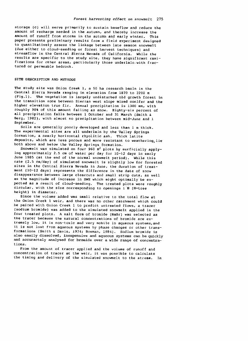
Forest Hydrology and Watershed Management -Hydrologie Forestiere et Aaenage8ent des Bassins Hydrologiques (Proceedings of the Vancouver Symposium, August 1987; Actes du Co11oque de Vancouver, Aofit 1987):IAHS-AISH Pub1.no.167,1987. Forest harvest, snowmelt and streamflow in the central Sierra Nevada L. H. MACDONALD Hydrologist, Pacific Southwest Forest and Range Experiment Station, Forest Service, U.S. De- partment of Agriculture, Berkeley, CA, USA ABSTRACT Forest harvest techniques have often been suggested as a means of increasing snow accumulation and beneficially delaying snowmelt in the Northern and Cen- tral Sierra Nevada mountains in California. To test the effect of such management practices on streamflow, ex- tended snowmelt was simulated in June 1985 on four 960 m2 plots in a 50 ha drainage basin. Less than 1% of a bromide tracer in the simulated snowmelt was detected at a downstream weir through the summer and early fall of 1985. Although significant increases in the water .table and soil moisture content were found in the treated plots and, in some cases, downslope, the simulated snowmelt apparently did not. substantially increase streamflow in 1985. The consistently high concentrations of bromide observed at the weir in 1986 are believed to be a func- tion of basin lithology. The results to date cast doubt on the linkage that can be made between an increase in snow water equivalent on the hill slope and downstream discharge. La coupe, la fante et les debits dans le centre de la Sierra Nevada RESUME On a souvent suggere des techniques de coupe pour accroltre l'accumulation de la neige et retarder la fonte dans le nard et le centre de la Sierra Nevada, en Californie. Afin de tester l'effet d'un tel traitement sur les debits, on a simule une extension de la fonte en juin 1985 sur quatre parcelles de 960 m2 dans un bassin de 50 ha. Moins de 1% du bromure utilise comme traceur a ete detecte a un seuil en aval au cours de l'ete et de l'automne suivant. Malgre une augmentation de la teneur en eau du sol et une elevation de la nappe sur, et parfois en aval des parcelles traitees, la fonte simulee p'a eu aucun effet apparent sur les debits de 1985. Les fortes concentrations de bromures observees de fa~on constante en 1986 sembleraient etre dues a la lithologie du bassin. Les result~ts jet tent un doute sur la possibilite de relier une augmentat~on du couvert neigeux a une augmentation des debits. 273
-
Upload
vuongkhuong -
Category
Documents
-
view
221 -
download
3
Transcript of Forest harvest, snowmelt and streamflow in the central ... · PDF fileForest harvest, snowmelt...
Forest Hydrology and Watershed Management -HydrologieForestiere et Aaenage8ent des Bassins Hydrologiques(Proceedings of the Vancouver Symposium, August 1987; Actesdu Co11oque de Vancouver, Aofit 1987):IAHS-AISHPub1.no.167,1987.
Forest harvest, snowmelt and streamflow inthe central Sierra Nevada
L. H. MACDONALDHydrologist, Pacific Southwest Forest and RangeExperiment Station, Forest Service, U.S. De-partment of Agriculture, Berkeley, CA, USA
ABSTRACT Forest harvest techniques have often been
suggested as a means of increasing snow accumulation and
beneficially delaying snowmelt in the Northern and Cen-
tral Sierra Nevada mountains in California. To test the
effect of such management practices on streamflow, ex-
tended snowmelt was simulated in June 1985 on four 960 m2
plots in a 50 ha drainage basin. Less than 1% of a
bromide tracer in the simulated snowmelt was detected at
a downstream weir through the summer and early fall of
1985. Although significant increases in the water .table
and soil moisture content were found in the treated plots
and, in some cases, downslope, the simulated snowmelt
apparently did not. substantially increase streamflow in
1985. The consistently high concentrations of bromide
observed at the weir in 1986 are believed to be a func-
tion of basin lithology. The results to date cast doubt
on the linkage that can be made between an increase in
snow water equivalent on the hill slope and downstream
discharge.
La coupe, la fante et les debits dans le centre de la
Sierra Nevada
RESUME On a souvent suggere des techniques de coupe
pour accroltre l'accumulation de la neige et retarder la
fonte dans le nard et le centre de la Sierra Nevada, en
Californie. Afin de tester l'effet d'un tel traitement
sur les debits, on a simule une extension de la fonte en
juin 1985 sur quatre parcelles de 960 m2 dans un bassin
de 50 ha. Moins de 1% du bromure utilise comme traceur a
ete detecte a un seuil en aval au cours de l'ete et de
l'automne suivant. Malgre une augmentation de la teneur
en eau du sol et une elevation de la nappe sur, et
parfois en aval des parcelles traitees, la fonte simulee
p'a eu aucun effet apparent sur les debits de 1985. Les
fortes concentrations de bromures observees de fa~on
constante en 1986 sembleraient etre dues a la lithologie
du bassin. Les result~ts jet tent un doute sur la
possibilite de relier une augmentat~on du couvert neigeux
a une augmentation des debits.
273

274 L.H.MacDonald
INTRODUCTION
The deep winter snowpacks of the Sierra Nevada are of critical
importance with regard to both the volume and timing of California's
water supply. It has been estimated that 51% of the surface runoff
in California is derived from the snow zone (Anderson, 1963). The
lag between snowfall and snowmelt helps alleviate the temporal
asynchrony between supply and demand. With high-elevation water
often valued at over $0.16 per m3 ($200 per acre-foot) (Romm &
Ewing, 1987) and excess snowmelt runoff making reservoir spillage a
common event for some reservoirs (MacDonald, 1986a), snow management
techniques which reduce snowmelt runoff peaks and/or extend snowmelt
runoff have long been of interest.
Church (1912) concluded that the ideal forest in the Sierra
Nevada would have many small shaded openings which would both ac-
cumulate snow and delay melt. Since then numerous forest harvest
trials have produced highly variable results (Kattelmann, 1982;
McGurk & Berg, 1987). Estimated values for the increase in maximum
SWE (snow water equivalent) in cut openings and narrow strips as
compared to the uncut forest are 39 cm (Kittredge, 1953), 33 cm
(Anderson & Gleason, 1959), and 25 cm (Anderson, 1963).
These values are for maximum SWE, however, and the persistence of
this increased SWE during the snowmelt period is much more uncer-
tain. Large clearcuts have been shown to increase the rate of
spring snowmelt by up to 50% (to a maximum of 4-5 cm SWE per day)compared to uncut forest, and this shifts the disappearance of snow
forward by approximately 16 days (Anderson, 1963) .In the case of small
patch or narrow strip cuts, melt rates may be slightly higher
than melt rates in the uncut forest, so the increased SWE in small
openings will postpone the disappearance of the snow by at most a
few days (Kattelmann, 1982; McGurk & Berg, 1987).
Cloud-seeding is another means of manipulating the Sierra snow-
pack, and this is being practiced by several public utilities. The
untested assumption is that an increase in maximum SWE will be
transformed into a useful increase in streamflow. Early studies
claimed a 32% increase in precipitation from cold westerly storms in
the Lake Almanor catchment basin (Mooney & Lunn, 1969) and a 6%
increase in runoff in the Kings River basin (Henderson, 1966). More
intensive studies by the U.S. Bureau of Reclamation suggest an
increase in precipitation of closer to 1% (Reynolds & Dennis, 1984),
but even small increases in precipitation represent a substantial
volume of water if achieved over a large area.
This assumption--that an increase in snow water equivalent or a
delay in snowmelt beneficially affects streamflow--is conceptually a
question of how additional snowmelt will be partitioned among:
(a) relatively rapid surface or subsurface flow to the stream
channel;(b) evapotranspiration; and
(c) groundwater storage.Both (a) and (c) should result in the desired increase in water
yield, but the timing of this increased yield will be quite dif-
ferent. By definition, (a) will increase streamflow on the reces-
sion limb of the snowmelt hydrograph and thus contribute to late
spring and early summer streamflow. Water entering groundwater
Forest harvesting effect on snowmelt 275
storage (c) will serve primarily to sustain baseflow and reduce the
amount of recharge needed in the autumn, and thereby increase the
amount of runoff from storms in the autumn an~ early winter. This
paper presents preliminary results from a field experiment designedto quantitatively assess the linkage between late season snowmelt
(due either to cloud-seeding or forest harvest techniques) and
streamflow in the Central Sierra Nevada of California. While the
results are specific to the study site, they have significant rami-
fications for other areas, particularly those underlain.with frac-
tured or permeable bedrock.
SITE DESCRIPTION AND METHODS
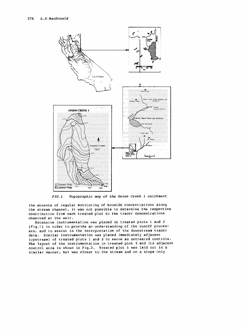
The study site was Onion Creek 1, a 50 ha research basin in the
Central Sierra Nevada ranging in elevation from 1870 to 2200 m
(Fig.l). The vegetation is largely undisturbed old growth forest in
the transition zone between Sierran west slope mixed conifer and the
higher elevation true fir. Annual precipitation is 1300 mm, with
roughly 90% of this amount falling as snow. Eighty-six percent of
all precipitation falls between 1 October and 31 March (Smith &
Berg, 1982), with almost no precipitation between mid-June and 1
September.Soils are generally poorly developed and less than 1 m thick.
The experimental sites are all underlain by the Valley Springs
formation, a nearly horizontal rhyolitic ash. Thick latite
deposits, which are less porous and more resistant to weathering, lieboth above and below the Valley Springs formation.
Snowmelt was simulated on four 960 m2 plots by surficially apply-
ing approximately 2.5 cm of water per day for 10-12 days in earlyJune 1985 (at the end of the normal snowmelt period). While this
rate (2.5 cm/day) of simulated snowmelt is slightly low for forested
sites in the Central Sierra Nevada in June, the duration of treat-
ment (10-12 days) represents the difference in the date of snow
disappearance between large clearcuts and small strip cuts, as wellas the magnitude of increase in SWE which might optimally be ex-
pected as a result of cloud-seeding. The treated plots were roughly
circular, with the size corresponding to openings 1 H (H=tree
height) in diameter.
Since the volume added was small relative to the total flow at
the Onion Creek 1 weir, and there was no other catchment which could
be paired with Onion Creek 1 to predict untreated flows, a tracer
(sodium bromide) was added to the simulated snowmelt applied in the
four treated plots. A salt form of bromide (NaBr) was selected as
the tracer because the natural concentrations of bromide are ex-
tremely low, it is non-toxic and very mobile in aqueous systems,andit is not lost from aqueous systems by phase changes or other trans-
formations (Smith & Davis, 1974; Bowman, 1984). Sodium bromide is
also easily dissolved, inexpensive and aqueous systems can be quickly
and accuractely analyzed for bromide over a wide range of concentra-
tions.
From the amount of tracer applied and the volume of runoff and
concentration of tracer at the weir, it was possible to calculate
the timing and delivery of the simulated snowmelt to the stream. In
276 L.H.MacDonald
~ Vc~1
:;1 '~1~,.~
.,. :...\,
)
...~...
.,
::. ...
ONION CREEK I
2130
"
A.
E- "' m-.,
~.OOM
()..,"c,."'
(l8S)m)~ 2070
-.: j ~
G)Treated Pk>ts ' .
~Control Pk>ts 20'01950 "90
Topographic map of the Onion Creek 1 catchment.FIG.l
the absence of regular monitoring of bromide concentrations along
the stream channel, it was not possible to determine the respective
contribution from each treated plot to the tracer concentrations
observed at the weir.Extensive instrumentation was placed in treated plots 1 and 3
(Fig.l) in order to provide an understanding of the runoff proces-
ses, and to assist in the interpretation of the downstream tracer
data. Similar instrumentation was placed immediately adjacent(upstream) of treated plots land 3 to serve as untreated controls.
The layout of the instrumentation in treated plot 3 and its adjacent
control area is shown in Fig.2. Treated plot 1 was laid out in a
similar manner, but was closer to the stream and on a slope only

Forest harvesting effect on snowmelt 277
half as steep (16% vs. 30%). Typical depths for the nests of ten-
siometers and soil water samplers in both plots was 30, 70 and 90-
120 cm (a more detailed description of instrumentation can be found
in MacDonald, 1986b). In 1986 additional tensiometers, piezometers
and soil moisture blocks were placed up slope of the treated and
control plots in order to clarify the effect of the treatment, and
additional piezometers were installed at depths of 1.5-4.5 m to
permit monitoring of groundwater levels throughout the summer.
In 1985 and 1986 simulated snowmelt began when the snow still
covered about 10% of the study area. In order to avoid confounding
the bromide results, no tracer was used in 1986. Soil water, lit-
ter, soil and foliage samples were collected in both 1985 and 1986.

278 L.H.MacDonald
All the bromide analyses reported here were done with a Dionexl ion
chromatograph. Aqueous extracts were used to determine the bromide
concentrations in the soil, foliage and litter samples (Abdalla &
Lear, 1975).A Guelph permeameter (Soil Moisture Equipment) was used to
measure the saturated hydraulic conductivity in the soils and decom-
posed rhyolite. Constant head tests in each piezometer (U.S. Dept.
of Interior, 1980) provided estimates of the hydraulic conductivity
belowa depth of 1.2 m.
RESULTS AND DISCUSSION
Given a reliable detection limit of approximately 5 ppb, there was
no significant increase in bromide at the Onion Creek 1 weir until a
week after the surficial application of simulated snowmelt had
ceased (Fig.3). In 1985 bromide concentrations peaked at about
35 ppb 2-4 weeks after the end of the simulated snowmelt, and re-
mained only slightly above the detection limit until the end of
August. In October there was no consistent indication of elevated
bromide levels, even though 76 mm of precipitation fell in September
and 40 mm in October. Multiplying concentration by discharge indi-
cates that only loo g (0.04%) of the 280 kg of bromide tracer left
the drainage basin by 31 October 1985.
150' r 300
250120
200Bromide
Concentration
(ppb)
D.h 90
ISC arge
{liters/s) 60
150
~I "". 100
30 50
0-1 April
01 July 1 October 1 Jonuory 1 April 1 July
1985 1986
Date
FIG.3 Bromide concentrations and average daily dis-charge at the Onion Creek 1 weir.
lMention of a specific product does not imply endorsement by the us
Forest Service.

279Forest harvesting effect on snowmelt
Bromide concentrations in late February 1986 at the Onion Creek 1
wejr were nearly 10 times greater than in the previous summer.
These higher concentrations, combined with high discharges due to a
series of rain-on-snow events, resulted in an estimated flux of
33 kg of bromi.de between 24 February and 21 March 1986. Bromide
concentrations were lower but relatively stable throughout the
spring melt period, and from 21 March to 17 July approximately 28 kg
of bromide passed over the Onion Creek 1 weir. From 17 July to mid-
October 1986 there were no major discharge events, and bromide
concentrations have remained in the range of 50-70 ppb. For the
period 1 November 1985 to 24 February 1986 stream water samples were
not available, but average daily discharge exceeded 20 1 s-l for
only two days prior to II February. Severe storms from 12-22 Febru-
ary produced high discharges, but in the absence of both streamflow
and tracer data the flux of bromide can only be crudely estimated at
20-25 kg. Thus in the fifteen months following the application of
the tracer on the sideslopes, approximately 30% (80-86 kg) of the
bromide tracer left the Onion Creek 1 catchment as streamflow. This
relatively low percentage suggested that bromide might not be a
conservative tracer, and for this reason soil, litter and foliage
samples were analyzed for their bromide content.
Bromide concentrations in soil samples taken at various depths
and locations, when combined with bulk density data and corrected
for rock content, indicated that approximately 4 kg of bromide
tracer remained in both site land site 2 in the summer of 1986.
Similar calculations showed approximately 1 kg of bromide downslope
from each of the two plots. Assuming the other two sites are simi-
lar, the soils in all the treated plots and downslope areas could be
estimated to contain perhaps 20 kg of bromide, or less than 10% of
the total applied.
Bromide concentrations in litter samples collected in the summer
of 1986 averaged 35 ppm (0.0035%) in the treated plots. Average
litter weight is approximately 5000 g m-2 in the study area, result-
ing in an estimated 170 g of bromide per treated plot, or 0.7 kg in
the stl,ldy area.
Bromide concentrations in the 1985 and 1986 foliage of small
trees in the treated plots was found to be 0.01-0.09% (100-900 ppm)
of their dry weight. From Stangenberger's (1979) values for foliage
weights in red fir forests and Zinke's (pers. corom.) estimate of the
life span of red fir needles, it can be estimated that approximately
1 kg of the bromide tracer has been taken up in the foliage.
The total amount of bromide absorbed or taken up and held within
the soil, litter and foliage is estimated to be 22 kg. While there
is some uncertainty associated with this estimate, the magnitude of
loss tends to confirm the validity of using bromide as a tracer.
If it is assumed that the bromide concentrations at the weir
reflect the delivery of the simulated snowmelt to the stream, it
appears that delayed melt was not effective in augmenting late
spring and early summer streamflow. Even if bromide is ~ assumed
to be a conservative tracer and concentrations at the weir are
multiplied by a factor of 4 to correct for known (soil, litter and
vegetation) and unknown losses, the amount of tracer delivered to
the stream throughout the summer of 1985 is still much less than 1%.
280 L.H.MacDonald
On the other hand, the tensiometer, piezometer and soil moisture
block data for 1985 consistently show that the simulated snowmelt
had a significant effect within the two intensively-monitored plots(MacDonald, 1986b). The treatment effect also extended to the
stream channel in the downslope area of plot 1, but apparently not
for treated plot 3 (Fig.2). While the increased height of the water
table dissipated rapidly once treatment ceased, the tensiometers and
soil moisture blocks indicated that the initial 10-12 day lag in the
soil drying curve due to the simulated snowmelt treatment persisted
for up to two months (MacDonald, 1986b). Preliminary review of the
1986 data indicates similar trends.The apparent conflict between the bromide tracer results and the
observed changes in groundwater and soil moisture can be reconciled
by reference to the hydrologic properties of the Onion Creek 1 soils
and substrate. First, however, it should be remembered that the
bromide concentrations at the weir did not peak in the summer of
1985 until 2-4 weeks after sprinkling had ceased. This small,
delayed peak of bromide suggests that pipe or macropore flow was not
transporting significant quantities of the simulated snowmelt to the
stream, even though groundwater levels were less than 1 m below the
surface (and hence well within the rooting zone) for several sites
for some or all of the treatment period.
Measured saturated hydraulic conductivities for the soil at
depths of 60 and 90 cm were all in the range of 2 x 10⁻⁴ to 9 x
10-4 cm S-l. Using the high value of 9 x 10⁻⁴ cm s-l, a horizontal
distance of 20 m to the stream channel for Site 2, and a slope of
32%, it would take 80 days for the tracer to reach the stream.
Similar calculations for Site 1 yield a minimum transit time of loo
days. However, in both 1985 and 1986 the water table had dropped to
the C horizon no more than 10 days after the cessation of
sprinkling. Soil water content remained at or above field capacity
for another 4-6 weeks, but hydraulic conductivity declines dramati-
cally with desaturation (Bloemen, 1980). Since the measured hydrau-
lic conductivity of the underlying rhyolite is on the order of 10-5
to 10-7 cm s-l, the transient increase in groundwater levels and
soil moisture due to the simulated snowmelt treatment cannot be
expected to result in a substantial increase in the delivery of
water to the stream channel.The key factors controlling the delivery of the simulated snow-
melt to the stream are the distance to the stream channel, steepness
of the slope, flow path to the channel, and effective hydraulic
conductivity. Changes in anyone of these could substantially alter
the transit time of the simulated snowmelt, and hence the likelihood
of being lost to evapotranspiration. Assuming "typical" values of
50 m from a stream channel and a slope of 35%, the hydraulic conduc-
tivity would have to be 2 x 10⁻² cm s-l if the simulated snowmelt is
to reach the stream within 10 days. This suggests that relatively
few sites would be capable of delivering substantial quantities of
late season snowmelt to the stream. Alternatively, if one assumes
that piston or translatory flow is an effective means of generating
runoff, it may be possible to have both the observed pattern of
tracer and a significant increase in summer streamflow. These
aspects are expected to be further quantified through the use of a
Forest harvesting effect on snowmelt 281
physically-based saturated and unsaturated transient and steady-
state porous media flow model.
One of the more surprising results in the study has been the
consistently high levels of bromide observed at the Onion Creek 1
weir fifteen months after the tracer was applied on the side slopes.
This suggests a large storage capacity and a relatively long reten-
tion time, and a variety of evidence indicates that this is a func-
tion of the underlying lithology rather than the overlying soils.
First, the remarkably stable concentration of the tracer through
sprinq snowmelt and the summer baseflow period (precipitation from
mid-May tomid-September 1986 was only 14 nun) suggests that the stream-
flow was derived primarily from deeper sources. Second, the amount
of tracer remaining in the soil is relatively small, and the extreme
dryness of the soils in the latter part of the summer precludes any
contribution to streamflow. Third, rock samples taken at depths of
1-5 m during spring 1986 have an effective porosity of 15-27%, and
since the ash deposit under the study site is on the order of 30 m
thick, the potential exists for storing large quantities of water.
CONCLUSIONS
The bromide tracer results suggest that much less than 1% of the
simulated snowmelt actually contributed to late spring runoff and
summer baseflow. While the groundwater and soil moisture data
indicate a clear and persistent effect, there was insufficient time
for this supplemental input to reach the stream before desaturation
occurred ~nd the rate of flow approached zero. That proportion of
simulated snowmelt which did not percolate below the rooting zone is
assumed to have been used for evapotranspiration over the dry
California summer.
If neither translatory flow nor macropore flow are important
means for delivering up slope snowmelt to the stream channel, the
only means by which the simulated snowmelt could be transformed into
useful runoff is if the applied water seeps into a groundwater
storage layer which is not available to the vegetation. In this
case less recharge would be needed in the following autumn, and the
amount of runoff in late fall and early winter would be correspond-
ingly increased. The timing of such an increase is optimal for the
generation of hydroelectricity, as reservoirs are typically at their
lowest levels in the fall and there is no chance of spillage
(MacDonald, 1986a). There are strong indications that most of the
tracer in the Onion Creek 1 catchment has entered into deep storage,
but whether this has been transformed into the desired beneficial
effect on streamflow is a question that cannot yet be fully answer-
ed. It is expected that current modelling efforts will help quan-
tify the controlling processes, and assist in extrapolating from
these results--which are based on specific plots in a single catch-
ment--to other areas.
ACKNOWLEDGEMENTS I am very grateful to the Division of Atmospheric
Sciences of the U.S. Bureau of Reclamation for their support of the
research, and the staff of the U.S. Forest Service, particularly the
282 L.H.MacDonald
Central Sierra Snow Laboratory, for their assistance in carrying out
this project.
REFERENCES
Abdalla, N.A. & Lear, B. (1975) Determination of inorganic bromidein soils and plant tissues with a bromide selective-ion elec-trode. Commun. in Soil Science and Plant Analysis 6, 489-494.
Anderson, H.W. (1963) Managing California's snow zone lands forwater. Research Paper PSW-6, Pacific Southwest Forest and RangeExperiment Station, USDA Forest Service.
Anderson, H.W. & Gleason, C.H. (1959) Logging effects on snow, soilmoisture and water losses. Proc., 28th Western Snow Conf., 57-65.
Bloemen, G.W. (1980) Calculation of hydraulic conductivities ofsoils from texture and organic matter content. z.Pflanzenernaehr. Bodenkunde 143, 581-605.
Bowman, R.S. (1984) Evaluation of some new tracers for soil waterstudies. Soil Sci. Soc. Am. J. 48, 987-993.
Church, J.E. (1912) The conservation of snow: its dependence onforest and mountains. Scientific American Supplement 74, 152-155.
Henderson, T.J. (1966) A ten-year non-randomized cloud seedingprogram on the Kings River in California. J. of Applied Meteo~rology 5, 697-702.
Kattelmann, R.C. (1982) Water yield improvement in the Sierra Nevadasnow zone: 1912-1982. Proc., 50th Western Snow Conf., 39-46.
Kittredge, J. (1953) Influences of forests on snow in the ponderosa-sugar pine-fir zone of the central Sierra Nevada. Hilgardia22(1), 1-96.
MacDonald, L.H. (1986a) Managing for water yield: the importance oftiming. Proc., California Watershed Management Conference, 55.Wildland Resources Centre, University of California, Berkeley,California, USA.
MacDonald, L.H. (1986b) Persistence of soil moisture changes result-ing from artificially extended snowmelt. Proc., 54th WesternSnow Conf., 146-149.
McGurk, B.J. & Berg, N.H. (1987) Snow redistribution: strip cuts atYuba Pass, California (this volume).
Mooney, M.L. & Lunn, G.W. (1969) The area of maximum effect result-ing from the Lake Almanor randomized cloud seeding experiment.J. of Applied Meteorology 8, 68-74.
Reynolds, D.W. & Dennis, A.S. (1984) Project Skywater: Fall 1984Status Report. Division of Atmospheric Resources Research,Bureau of Reclamation, Denver, Colorado, USA.
Rornm, J. & Ewing, A. (1987) Economic value of water in NationalForest management. Proc., California Watershed Management Con-ference, 89-102. Wildland Resources Centre, University ofCalifornia, Berkeley, California, USA.
Smith, S.J. & Davis, R.J. (1974) Relative movement of bromide andnitrate through soils. J. of Environmental Quality 3, 152-155.
Stangenberger, A.G. (1979) A simulation of nutrient cycling in redfir (Abies magnifica) and Douglas-fir (Pseudotsuga menziesii)

Forest harvesting effect on snowmelt 283
forests. PhD The$is, University of California, Berkeley, USA.
U.S. Department of the Interior (1980) Earth Manual. Water and Power
Resources Service, U.S. Dept. of the Interior, Washington, D.C.,
USA.