Force to Acquire High Grade Copper Projects in Oman
27
Force Commodities Ltd | Unit 47, First Floor, 1008 Wellington Street, West Perth, WA, 6005 | P: +61 8 6270 4694 | web:forcecommodities.com.au | Email: [email protected] | ABN 12 145 184 667 | ASX:4CE 1 September 2020 Force to Acquire High Grade Copper Projects in Oman Force Commodities Limited (ASX:4CE) (Force) has entered into a Share Purchase Agreement (SPA) to acquire interests in the Block 4 and Block 5 copper projects (the Projects) located in the Sultanate of Oman (Figure 1) from AIM listed Savannah Resources Plc (AIM:SAV) (Savannah). The acquisition of the Projects that contain part of one of the best preserved copper-rich Ophiolite belts in the world, forms part of Force’s growth strategy of building a multi-commodity (Cu-Au-Ag) exploration and development company. Transaction and Asset Overview • Force is acquiring 100% of Savannah’s wholly owned subsidiary, Savannah Resources B.V., which, via its subsidiaries, has a 51% interest in Block 4 (granted Exploration Licence), a 65% interest in Block 5 (granted Exploration Licence and 2 Mining Lease applications) and a 70% interest in two Exploration Licence applications near Block 10 to the west of Blocks 4 and 5 • The Projects cover 999 km² of the copper-rich Ophiolite belt in the Sultanate of Oman, proven to host clusters of relatively high grade VHMS copper deposits. Resources within these deposits are metallurgically simple and contain gold and silver credits • Measured, Indicated and Inferred Mineral Resources (2012 JORC) of 0.82Mt at 3.4% Cu (including a high-grade zone of approximately 0.5Mt at 4.5% Cu) in two deposits within Block 5 (Tables 1-3) • Contained metal reported at 28,000 tonnes of Copper, 5,900 ounces of Gold and 220,000 ounces of Silver (Table 3) • Opportunity to significantly increase resources in Block 5: o High grade intersections reported to date include 55.6 metres at 6.32% Cu from 63.2 metres in hole B5MB4D071 from Block 5 (Mahab 4 prospect) (Tables 4 and 5) o Priority exploration targets for future exploration include Maqail South and Mahab 4 extensions, Hara Kilab and Mahab 2 • Multiple prospects within Block 4 and 5 at a variety of stages of exploration from preliminary evaluation up to JORC (2012) Mineral Resources categories • Exploration will initially target the current Mineral Resources with the view to resource expansion, pre-feasibility and development • Oman has low sovereign risk and is an excellent low-cost operating region with well- developed road, power, port infrastructure, low fuel costs and a favourable fiscal regime • Purchase price is 50,000,000 fully paid ordinary shares in the capital of Force on acquisition completion, repayment of AUD$3.5M of a loan indirectly owing to Savannah to be paid upon the achievement of mine development and production milestones and a 1.0% NSR royalty on Force’s respective proportion of metal sales from Block 4 and Block 5 For personal use only
Transcript of Force to Acquire High Grade Copper Projects in Oman

Force Commodities Ltd | Unit 47, First Floor, 1008 Wellington Street, West Perth, WA, 6005 | P: +61 8 6270 4694 | web:forcecommodities.com.au | Email: [email protected] | ABN 12 145 184 667 | ASX:4CE
1 September 2020
Force to Acquire High Grade Copper Projects in Oman Force Commodities Limited (ASX:4CE) (Force) has entered into a Share Purchase Agreement (SPA) to acquire interests in the Block 4 and Block 5 copper projects (the Projects) located in the Sultanate of Oman (Figure 1) from AIM listed Savannah Resources Plc (AIM:SAV) (Savannah). The acquisition of the Projects that contain part of one of the best preserved copper-rich Ophiolite belts in the world, forms part of Force’s growth strategy of building a multi-commodity (Cu-Au-Ag) exploration and development company. Transaction and Asset Overview
• Force is acquiring 100% of Savannah’s wholly owned subsidiary, Savannah Resources B.V., which, via its subsidiaries, has a 51% interest in Block 4 (granted Exploration Licence), a 65% interest in Block 5 (granted Exploration Licence and 2 Mining Lease applications) and a 70% interest in two Exploration Licence applications near Block 10 to the west of Blocks 4 and 5
• The Projects cover 999 km² of the copper-rich Ophiolite belt in the Sultanate of Oman, proven to host clusters of relatively high grade VHMS copper deposits. Resources within these deposits are metallurgically simple and contain gold and silver credits
• Measured, Indicated and Inferred Mineral Resources (2012 JORC) of 0.82Mt at 3.4% Cu (including a high-grade zone of approximately 0.5Mt at 4.5% Cu) in two deposits within Block 5 (Tables 1-3)
• Contained metal reported at 28,000 tonnes of Copper, 5,900 ounces of Gold and 220,000 ounces of Silver (Table 3)
• Opportunity to significantly increase resources in Block 5: o High grade intersections reported to date include 55.6 metres at 6.32% Cu from
63.2 metres in hole B5MB4D071 from Block 5 (Mahab 4 prospect) (Tables 4 and 5) o Priority exploration targets for future exploration include Maqail South and Mahab
4 extensions, Hara Kilab and Mahab 2 • Multiple prospects within Block 4 and 5 at a variety of stages of exploration from
preliminary evaluation up to JORC (2012) Mineral Resources categories • Exploration will initially target the current Mineral Resources with the view to resource
expansion, pre-feasibility and development • Oman has low sovereign risk and is an excellent low-cost operating region with well-
developed road, power, port infrastructure, low fuel costs and a favourable fiscal regime • Purchase price is 50,000,000 fully paid ordinary shares in the capital of Force on acquisition
completion, repayment of AUD$3.5M of a loan indirectly owing to Savannah to be paid upon the achievement of mine development and production milestones and a 1.0% NSR royalty on Force’s respective proportion of metal sales from Block 4 and Block 5
For
per
sona
l use
onl
y
2
Force’s CEO Simon Pooley commented: “The acquisition of Savannah’s Oman copper project is a major milestone in cementing Force’s position as a multi-commodity exploration and development company and represents the first step in our strategy of establishing the Company as a copper producer. The acquisition of these highly prospective projects with multiple target areas provides Force with exposure to one of the most prospective Ophiolite belts in the world.
“Significantly, the Ophiolite belt is characterised by small to medium size, high grade copper deposits that have been shown to be amenable to low CAPEX, profitable open-cut development producing high quality copper concentrates for local or overseas smelters. Furthermore, despite the region’s rich history of copper production, there has been limited modern exploration in Oman, which Force and its Omani partners aim to capitalise on by applying rigorous, modern exploration techniques.
“We believe that with the application of systematic exploration and further commercial transactions, the opportunity exists in Oman to become a significant mid-tier copper producer.” Force will continue to search for further advanced gold projects within Australia in addition to advancing its high-grade Cu-Pb-Zn-Ag VHMS Halls Peak project in New South Wales. Acquisition Transaction – Savannah Resources B.V. (SRBV) The primary commercial terms of Force’s acquisition of 100% of the issued share capital of SRBV (the Transaction) are set out below:
1. Consideration at Settlement
• Issue to Savannah Resources Plc 50,000,000 FPO shares in the capital of Force (deemed issue price of 1 cent per Force share and subject to approval of shareholders)
2. Repayment of Loan on Production
• Repayment of AUD$3,500,000 in cash of an existing loan indirectly owing to Savannah, payable preferentially to Savannah from cash flow from production from Block 5
3. Payment of a 1.0% NSR (net smelter royalty) on Force’s respective proportion of metal sales from each of Block 4 and Block 5
Settlement of the transaction is conditional on certain conditions being satisfied or waived and notably includes Force undertaking the necessary steps to be re-admitted to trading on the ASX. This is expected to be completed by early October. Refer to Annexure A for a summary of the key terms and conditions of the SPA.
For
per
sona
l use
onl
y

3
Property and Location
The Block 4 licence covers an area of 403 km² and is located 50 km to the west of Sohar in Oman where significant port infrastructure is located. The centre of Block 5, covering an area of 598 km² is located 40 km south west of Sohar (Figure 1). Block 5 contains the Mahab 4 and Maqail South JORC 2012 Mineral Resources (Tables 1, 2 and 3).
Figure 1: Property Location Plan and Significant VMS Deposits
For
per
sona
l use
onl
y

4
Ownership and Licences
Force is acquiring 100% of the issued share capital of SRBV. SRBV has shareholder/ earn-in agreements with the holders of Blocks 4 and 5.
SRBV owns 51% of the issued capital of Al Thuraya Mining LLC (Al Thuraya), a company incorporated in the Sultanate of Oman. Al Thuraya holds the licence to Block 4. The Exploration Licence has been renewed for a further 12 months and expires on 24 March 2021. SRBV’s wholly owned subsidiary, Gentor Resources Limited hold 65% of the issued capital of the Al Fairuz Mining Company LLC (Al Fairuz). Al Fairuz holds the licence to Block 5. The Exploration Licence has been renewed for a further 12 months and expires on 8 August 2021. Two Mining Licence applications over the Mahab 4 and Maqail South deposits have interim approval and are awaiting grant pending issuance of the rent notices from the applicable regulatory bodies. SRBV’s wholly owned subsidiary, Gentor Resources Limited holds 70% of the issued capital of Sohar Mining LLC (Sohar). Sohar holds two Exploration Licence applications near Block 10 (Figure 1).
Project Setting
Oman is a well-developed country with excellent infrastructure (proximity to a major deep sea port, bitumen roads across both Projects and adjacent power lines), low fuel and labour costs and a favourable fiscal and tax regime. Force is of the opinion that mining profitability in Oman will be significantly enhanced by this very favourable development setting.
Mineral Resource Estimates Force will focus its exploration on the discovery of Cyprus style Volcanic Massive Sulphide (VHMS) deposits in the Samail Ophiolite. These VMS deposits are believed to form at active oceanic spreading centres where enhanced hydrothermal circulation leads to the formation of seafloor vents or black smokers (Figure 2). These vents inject a metal saturated solution into the water column, but the rapid drop in temperature leads to the immediate precipitation of metal onto the seafloor and sub-seafloor conduits as sulphides and oxides. Modern hydrothermal vents in mid-ocean ridge settings are often cited as a probable modern analogue for Cyprus style deposits in ancient Ophiolites, although there is some debate as to whether they represent mid-ocean ridges or supra- subduction settings in extensional back-arc basins.
For
per
sona
l use
onl
y

5
Figure 2: Generalised cross-section through a typical hydrothermal VMS system
Mineral Resources estimates for the Mahab 4 and Maqail South copper deposits and are given in Tables 1, 2 and 3.
Table 1: Mahab 4 Mineral Resource Estimate 0.5% Cu Cut-off
Domain Tonnes Cu Au Ag Cu Au Ag t % ppm ppm tonnes Ounces Ounces
Oxide Domain* Measured Indicated 22,000 0.2 1.4 14 40 1,000 10,000 Inferred
Total Oxide 22,000 0.2 1.4 14 40 1,000 10,000 Supergene Domain
Measured Indicated 11,000 14.8 1.1 41 1,700 400 15,000 Inferred
Total Supergene 11,000 14.8 1.1 41 1,700 400 15,000 Massive Sulphide Domain
Measured 307,000 5.3 0.3 14 16,300 3,000 143,000 Indicated 60,000 4.6 0.3 15 2,800 600 29,000 Inferred
Total Massive Sulphide 367,000 5.2 0.3 15 19,100 3,600 172,000 Disseminated Domain
Measured Indicated 64,000 0.6 0.05 2 400 100 4,000 Inferred 234,000 0.7 0.02 1 1,700 200 6,000
Total Disseminated 297,000 0.7 0.03 1 2,000 300 10,000 All Domains Measured 307,000 5.3 0.3 14 16,300 3,000 143,000 Indicated 157,000 3.1 0.4 11 4,900 2,100 58,000 Inferred 234,000 0.7 0.2 1 1,700 200 6,000
Total Mahab 4 Deposit 698,000 3.3 0.2 9 22,800 5,300 207,000 * Oxide reported at 0.5 ppm Au Cut-off
For
per
sona
l use
onl
y
6
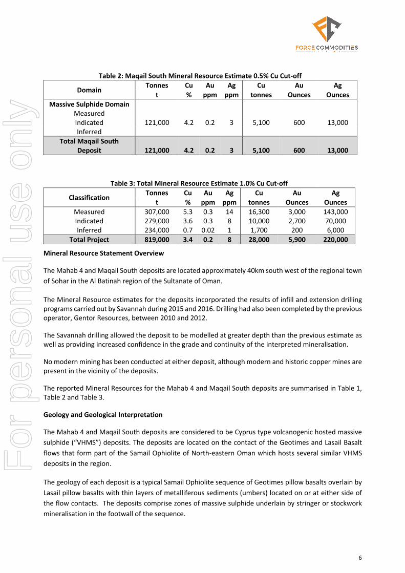
Table 2: Maqail South Mineral Resource Estimate 0.5% Cu Cut-off
Domain Tonnes Cu Au Ag Cu Au Ag t % ppm ppm tonnes Ounces Ounces
Massive Sulphide Domain Measured Indicated 121,000 4.2 0.2 3 5,100 600 13,000 Inferred
Total Maqail South Deposit 121,000 4.2 0.2 3 5,100 600 13,000
Table 3: Total Mineral Resource Estimate 1.0% Cu Cut-off
Classification Tonnes Cu Au Ag Cu Au Ag t % ppm ppm tonnes Ounces Ounces
Measured 307,000 5.3 0.3 14 16,300 3,000 143,000 Indicated 279,000 3.6 0.3 8 10,000 2,700 70,000 Inferred 234,000 0.7 0.02 1 1,700 200 6,000
Total Project 819,000 3.4 0.2 8 28,000 5,900 220,000
Mineral Resource Statement Overview
The Mahab 4 and Maqail South deposits are located approximately 40km south west of the regional town of Sohar in the Al Batinah region of the Sultanate of Oman.
The Mineral Resource estimates for the deposits incorporated the results of infill and extension drilling programs carried out by Savannah during 2015 and 2016. Drilling had also been completed by the previous operator, Gentor Resources, between 2010 and 2012.
The Savannah drilling allowed the deposit to be modelled at greater depth than the previous estimate as well as providing increased confidence in the grade and continuity of the interpreted mineralisation.
No modern mining has been conducted at either deposit, although modern and historic copper mines are present in the vicinity of the deposits.
The reported Mineral Resources for the Mahab 4 and Maqail South deposits are summarised in Table 1, Table 2 and Table 3.
Geology and Geological Interpretation
The Mahab 4 and Maqail South deposits are considered to be Cyprus type volcanogenic hosted massive sulphide (“VHMS”) deposits. The deposits are located on the contact of the Geotimes and Lasail Basalt flows that form part of the Samail Ophiolite of North-eastern Oman which hosts several similar VHMS deposits in the region.
The geology of each deposit is a typical Samail Ophiolite sequence of Geotimes pillow basalts overlain by Lasail pillow basalts with thin layers of metalliferous sediments (umbers) located on or at either side of the flow contacts. The deposits comprise zones of massive sulphide underlain by stringer or stockwork mineralisation in the footwall of the sequence.
For
per
sona
l use
onl
y
7
The Mahab 4 deposit comprises a high-grade massive sulphide domain interpreted to be a sea-floor volcanic mound with a low grade disseminated/stockwork zone interpreted to be part of the sub-sea feeder fault. A supergene zone enriched in copper and gold is located immediately above the massive sulphide at a paleo water level. Weathering of the deposit has formed a near surface gold rich oxide domain. The massive sulphide zone is a sub vertical lens approximately 300m long, striking north-south. Mineralisation is approximately 10-30m wide and plunges gently to the north. The massive sulphide is mainly composed of pyrite and chalcopyrite with minor quartz stringers. Grades are consistently above 3% Cu and range from 3% to 10% Cu. The stockwork or disseminated mineralisation is dominated by fine pyrite and chalcopyrite in quartz stringers with grades typically less than 1% Cu. The supergene zone is located directly above the massive sulphide and contains secondary chalcocite formed at a paleo water table. Grades in this zone are typically elevated and range from 5% to 40% Cu. There is a very shallow weathering profile in the unmineralised rocks at Mahab 4 with fresh rock outcropping at surface. Minor oxidation of sulphides is seen in the near surface mineralisation with azurite and malachite observed. An interpreted weathering boundary has been used to separate this material from the primary mineralisation in the estimation. Associated gold, silver and zinc mineralisation occur within all mineralised domains and show a moderate correlation to copper content.
The Maqail South VHMS comprises a flat to gently eastward dipping massive sulphide sheet underlain by a moderately altered and typically weakly mineralised footwall sequence. The deposit covers an area of approximately 100m by 100m in plan. It is closed off to the west where the deposit daylights and also to the east where massive sulphide thins laterally into magnetite rich umbers. Mineralisation is approximately 20m thick in the centre, thinning laterally to less than 1m thick at the margins. The massive sulphide is mainly composed of pyrite and chalcopyrite with minor quartz stringers, grades are consistently above 3% Cu and range from 3% to 20% Cu.
A zone of patchy stockwork or disseminated mineralisation is located below the massive sulphide mound. Mineralisation is dominated by fine pyrite and chalcopyrite with grades with grades typically less than 0.5% Cu. The disseminated mineralisation has not been included in this estimate. Low levels of gold and silver mineralisation occur within the massive sulphide and show a moderate correlation to copper content.
There is a very shallow weathering profile at Maqail South with fresh rock outcropping at surface. None of the mineralisation has been oxidized and no weathering profiles have been used to separate the model based on weathered domains.
Drilling Techniques
Drilling at the deposits comprises surface diamond drill holes completed between 2010 and 2016. Approximately 25% of the drilling was completed by Savannah with the remainder completed by a previous operator. The Savannah drilling has confirmed and extended the mineralisation defined by previous drilling.
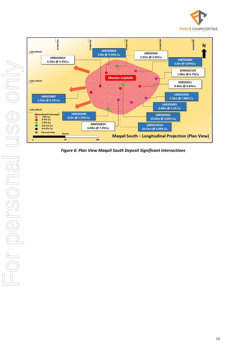
The Mahab 4 deposit is defined by 48 diamond drill holes for a total of 5,676m (Figures 3 and 5, Table 4). Holes were angled to the east and to the west and drilled at -50o to -70o. Drill hole spacing is approximately 20m by 20m in the upper part of the deposit and 40m to 60m in the deeper portion of the deposit.
For
per
sona
l use
onl
y

8
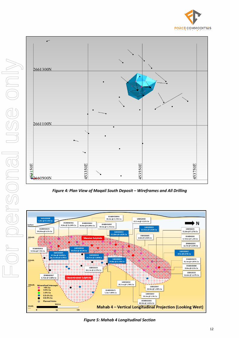
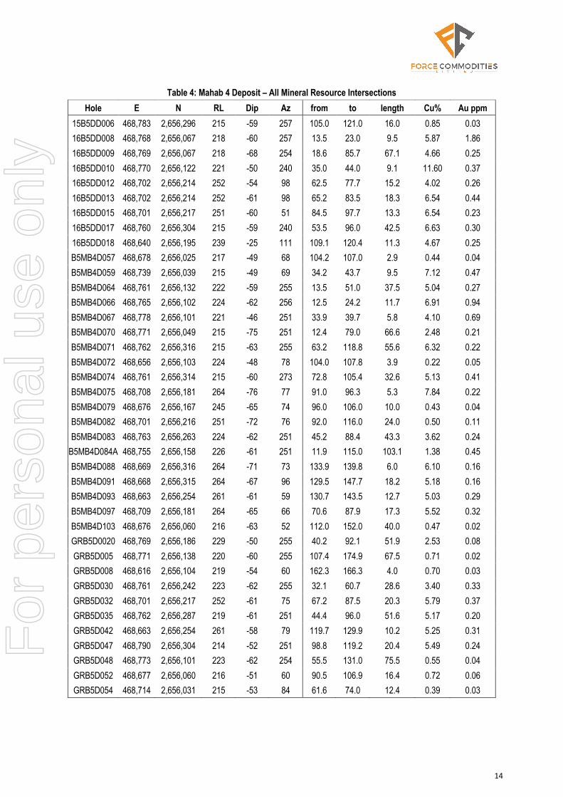
The Maqail South deposit is defined by 13 diamond drill holes for a total of 1,122m (Figures 4 and 6, Table 5). Holes were drilled as fans from three collar positions were angled at -50o to -80o. The drill holes intersected the deposit at spacings of 20m to 30m.
Drill hole collar co-ordinates were surveyed by qualified surveyors utilising a DGPS to an accuracy of 0.1cm using WGS84 Zone 40N co-ordinates. All estimation and modelling has been completed in WGS84 40N grid.
Downhole surveys have been carried out on the majority of drill holes using a Tropari single shot device. Drill holes completed by Gentor have typically been surveyed at the end of hole with the hole assumed to be straight. Drill holes completed by Savannah have been surveyed at 30m to 50m intervals. A small number of holes were not surveyed and have been assigned planned dips and azimuths.
Sampling and Sub-sampling Techniques
Diamond drilling was completed using HQ2 and NQ2 drilling equipment for all diamond holes. Core was sampled by cutting the core in half using a diamond saw. Sample intervals were based on observed geological boundaries with samples ranging in length from 0.1m to 2.0m. The typical sample length was 1.0m.
Sample Analysis Method
Samples from the Gentor drilling were prepared by the Gulf Geotech Laboratory in Muscat. The half core samples of approximately 2-3kg were crushed then split to 250-300g and dispatched to ALS laboratories in Romania. The samples were pulverised to 85% passing 75µm then assayed for gold using a 30g fire assay technique.
The remaining pulverised sample was then split to 100g and shipped to the ALS Laboratory in Vancouver, Canada, where analysis for Cu, Pb, Zn and Ag was completed using a four acid digest and ICP-OES finish.
Samples from the Savannah drilling were dispatched to Bureau Veritas (BV) laboratories in Turkey for preparation. The 2kg to 3kg half core samples were dried at 85˚C followed by crushing to 70% passing 2mm. A 500g split was then taken and pulverised to 85% passing 75µm. Analysis of Au was completed by 30g fire assay at the same BV facility in Turkey. Samples assaying >10g/t were re-analysed using a gravimetric finish.
Analysis for other elements was completed at a BV facility in Canada using a four acid digest with ICP-OES finish.
Quality control samples were routinely used in all drilling and included the use of certified reference material, duplicate sampling and umpire check assaying. The results of the QAQC samples were satisfactory and confirmed the quality of the data as suitable for use in Mineral Resource estimation.
Estimation Methodology
The deposits were estimated using ordinary kriging (“OK”) grade interpolation constrained by resource outlines based on mineralisation envelopes prepared using geological logging for the massive sulphide and supergene mineralisation domains and a combination of geological logging and a 0.2% Cu cut-off for the disseminated mineralisation domain at Mahab 4.
For
per
sona
l use
onl
y
9
At Mahab 4, a single sub-vertical lens of mineralisation was interpreted with the upper portion of the lens comprising supergene and massive sulphide mineralisation, with the stringer and stockwork mineralisation at depth. The Maqail South mineralisation was encompassed in a single, flat lying massive sulphide lens.
Interpolation parameters were based on geostatistical analysis and considered the geometry of the individual lenses. At Mahab 4, a first pass search of 30m with a minimum of 8 samples and a maximum of 32 samples was used which resulted in 98% of the blocks being estimated. A second pass with a search range of 200m filled the remaining blocks.
At Maqail South, a first pass search of 30m with a minimum of 8 samples and a maximum of 32 samples was used which resulted in 63% of the blocks being estimated. A second pass with a search range of 60m filled a further 35% of blocks. The remaining blocks were estimated using a 100m search with a minimum of 2 samples.
At Mahab 4, a high grade cut of 14% Cu was applied to the massive sulphide zone and a high grade cut of 2.5g/t Au was applied to the oxide zone. Cuts of 67g/t Ag and 10% Zn were applied to different domains but had minimal impact on the deposit grade.
No high grade cuts were applied to the Maqail South estimate.
Surpac block models were used for the estimates. At Mahab 4, a block size of 10m EW by 20m NS by 10m vertical with sub-cells of 0.625m by 1.25m by 0.625m was used. At Maqail South a block size of 20m EW by 20m NS by 5m vertical with sub-cells of 2.5m by 2.5m by 0.625m was used.
Bulk density values were based on drill core determinations. Values applied to the Mahab 4 model were 2.4t/m3 for Oxide and 2.7t/m3 for fresh country rock.
In the supergene, massive sulphide and disseminated zones, bulk density was estimated using ordinary kriging. Typical values of 3.8t/m3 in massive sulphide and 3.0t/m3 in disseminated mineralisation were estimated in the models.
At Maqail South, unmineralised rock was assigned a density of 2.68t/m3 and for the massive sulphide domain bulk density was estimated using ordinary kriging.
Mineral Resource Classification
The Mahab 4 deposit has been classified as Measured, Indicated and Inferred Mineral Resource. The Measured classification was defined within the area where the drill spacing was 25m or less and the continuity of grade and thickness was excellent. Indicated Mineral Resource was defined within areas of reasonably close spaced drilling (approximately 25m by 25m) showing good continuity and predictability of the lode positions. Areas with larger drill spacing have been classified as Inferred Mineral Resource which is typically in the deeper portions of the disseminated domain of the deposit where the drill spacing is 40m to 60m. The classifications have been supported by analysis of the kriging efficiencies calculated for the estimation.
The Maqail South deposit has been classified entirely as Indicated Mineral Resource. The Indicated resource was defined due to reasonably close spaced drilling (approximately 25m by 25m) and the good continuity and predictability of the mineralisation.
For
per
sona
l use
onl
y

10
Cut-off Grades
The Mahab 4 and Maqail South deposits are located in a region with existing mining infrastructure and have the potential to be included as satellite deposits within a larger mining project. The Mahab 4 deposit is shallow and sub-cropping, and good potential exists for underground mining at the project. The Mineral Resource has been reported at a 0.5% Cu Au lower cut-off to reflect potential exploitation by low cost underground mining.
At Maqail South, the massive sulphide is uniformly high grade and the entire deposit is greater than 2% Cu. The deposit is between 50m and 100m from surface which may allow for open pit mining. The Mineral Resource has been reported at a 0.5% Cu Au lower cut-off to reflect the open pit potential.
Metallurgy
Metallurgical test work at both deposits has been completed by both Gentor and Savannah. Results of the work indicate that a saleable copper concentrate can be produced from a standard flotation plant. Optimised testing completed by Perth based consulting group IMO achieved >90% recovery and produced a copper concentrate with a grade of >20% Cu using a standard milling and flotation circuit.
Modifying Factors No modifying factors were applied to the reported Mineral Resources. Parameters reflecting mining dilution, ore loss and metallurgical recoveries will be considered during the planned mining evaluation of the Block 5 Project.
COMPETENT PERSONS’ STATEMENT
The Information in this ASX Announcement that relates to Exploration Results and Mineral Resources is based on information compiled by Mr Paul Payne, a Competent Person who is a Fellow of the Australasian Institute of Mining and Metallurgy. Mr Payne is a full-time employee of Payne Geological Services. Mr Payne has sufficient experience that is relevant to the style of mineralisation and type of deposit under consideration and to the activity being undertaken to qualify as a Competent Person as defined in the 2012 Edition of the “Australasian Code for Reporting of Exploration Results, Mineral Resources and Ore Reserves”. Mr Payne consents to the inclusion in this ASX Announcement of the matters based on his information in the form and context in which it appears.
For
per
sona
l use
onl
y

11
Figure 3: Plan View of Mahab 4 Deposit – Wireframes and All Drilling
For
per
sona
l use
onl
y
12
Figure 4: Plan View of Maqail South Deposit – Wireframes and All Drilling
Figure 5: Mahab 4 Longitudinal Section
For
per
sona
l use
onl
y
13
Figure 6: Plan View Maqail South Deposit Significant Intersections
For
per
sona
l use
onl
y
14
Table 4: Mahab 4 Deposit – All Mineral Resource Intersections Hole E N RL Dip Az from to length Cu% Au ppm
15B5DD006 468,783 2,656,296 215 -59 257 105.0 121.0 16.0 0.85 0.03 16B5DD008 468,768 2,656,067 218 -60 257 13.5 23.0 9.5 5.87 1.86 16B5DD009 468,769 2,656,067 218 -68 254 18.6 85.7 67.1 4.66 0.25 16B5DD010 468,770 2,656,122 221 -50 240 35.0 44.0 9.1 11.60 0.37 16B5DD012 468,702 2,656,214 252 -54 98 62.5 77.7 15.2 4.02 0.26 16B5DD013 468,702 2,656,214 252 -61 98 65.2 83.5 18.3 6.54 0.44 16B5DD015 468,701 2,656,217 251 -60 51 84.5 97.7 13.3 6.54 0.23 16B5DD017 468,760 2,656,304 215 -59 240 53.5 96.0 42.5 6.63 0.30 16B5DD018 468,640 2,656,195 239 -25 111 109.1 120.4 11.3 4.67 0.25 B5MB4D057 468,678 2,656,025 217 -49 68 104.2 107.0 2.9 0.44 0.04 B5MB4D059 468,739 2,656,039 215 -49 69 34.2 43.7 9.5 7.12 0.47 B5MB4D064 468,761 2,656,132 222 -59 255 13.5 51.0 37.5 5.04 0.27 B5MB4D066 468,765 2,656,102 224 -62 256 12.5 24.2 11.7 6.91 0.94 B5MB4D067 468,778 2,656,101 221 -46 251 33.9 39.7 5.8 4.10 0.69 B5MB4D070 468,771 2,656,049 215 -75 251 12.4 79.0 66.6 2.48 0.21 B5MB4D071 468,762 2,656,316 215 -63 255 63.2 118.8 55.6 6.32 0.22 B5MB4D072 468,656 2,656,103 224 -48 78 104.0 107.8 3.9 0.22 0.05 B5MB4D074 468,761 2,656,314 215 -60 273 72.8 105.4 32.6 5.13 0.41 B5MB4D075 468,708 2,656,181 264 -76 77 91.0 96.3 5.3 7.84 0.22 B5MB4D079 468,676 2,656,167 245 -65 74 96.0 106.0 10.0 0.43 0.04 B5MB4D082 468,701 2,656,216 251 -72 76 92.0 116.0 24.0 0.50 0.11 B5MB4D083 468,763 2,656,263 224 -62 251 45.2 88.4 43.3 3.62 0.24
B5MB4D084A 468,755 2,656,158 226 -61 251 11.9 115.0 103.1 1.38 0.45 B5MB4D088 468,669 2,656,316 264 -71 73 133.9 139.8 6.0 6.10 0.16 B5MB4D091 468,668 2,656,315 264 -67 96 129.5 147.7 18.2 5.18 0.16 B5MB4D093 468,663 2,656,254 261 -61 59 130.7 143.5 12.7 5.03 0.29 B5MB4D097 468,709 2,656,181 264 -65 66 70.6 87.9 17.3 5.52 0.32 B5MB4D103 468,676 2,656,060 216 -63 52 112.0 152.0 40.0 0.47 0.02 GRB5D0020 468,769 2,656,186 229 -50 255 40.2 92.1 51.9 2.53 0.08 GRB5D005 468,771 2,656,138 220 -60 255 107.4 174.9 67.5 0.71 0.02 GRB5D008 468,616 2,656,104 219 -54 60 162.3 166.3 4.0 0.70 0.03 GRB5D030 468,761 2,656,242 223 -62 255 32.1 60.7 28.6 3.40 0.33 GRB5D032 468,701 2,656,217 252 -61 75 67.2 87.5 20.3 5.79 0.37 GRB5D035 468,762 2,656,287 219 -61 251 44.4 96.0 51.6 5.17 0.20 GRB5D042 468,663 2,656,254 261 -58 79 119.7 129.9 10.2 5.25 0.31 GRB5D047 468,790 2,656,304 214 -52 251 98.8 119.2 20.4 5.49 0.24 GRB5D048 468,773 2,656,101 223 -62 254 55.5 131.0 75.5 0.55 0.04 GRB5D052 468,677 2,656,060 216 -51 60 90.5 106.9 16.4 0.72 0.06 GRB5D054 468,714 2,656,031 215 -53 84 61.6 74.0 12.4 0.39 0.03
For
per
sona
l use
onl
y
15
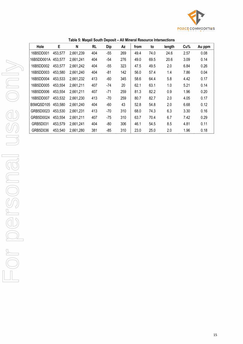
Table 5: Maqail South Deposit – All Mineral Resource Intersections Hole E N RL Dip Az from to length Cu% Au ppm
16B5DD001 453,577 2,661,239 404 -55 269 49.4 74.0 24.6 2.57 0.08 16B5DD001A 453,577 2,661,241 404 -54 276 49.0 69.5 20.6 3.09 0.14 16B5DD002 453,577 2,661,242 404 -55 323 47.5 49.5 2.0 6.84 0.26 16B5DD003 453,580 2,661,240 404 -81 142 56.0 57.4 1.4 7.86 0.04 16B5DD004 453,533 2,661,232 413 -60 345 58.6 64.4 5.8 4.42 0.17 16B5DD005 453,554 2,661,211 407 -74 20 62.1 63.1 1.0 5.21 0.14 16B5DD006 453,554 2,661,211 407 -71 259 81.3 82.2 0.9 1.96 0.20 16B5DD007 453,532 2,661,230 413 -70 259 80.7 82.7 2.0 4.05 0.17 B5MQSD105 453,580 2,661,240 404 -60 43 52.8 54.8 2.0 6.68 0.12 GRB5D0023 453,530 2,661,231 413 -70 310 68.0 74.3 6.3 3.30 0.16 GRB5D0024 453,554 2,661,211 407 -75 310 63.7 70.4 6.7 7.42 0.29 GRB5D031 453,579 2,661,241 404 -80 306 46.1 54.5 8.5 4.81 0.11 GRB5D036 453,540 2,661,280 381 -85 310 23.0 25.0 2.0 1.96 0.18
For
per
sona
l use
onl
y
16
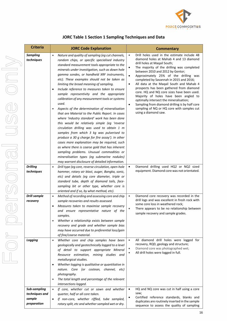
JORC Table 1 Section 1 Sampling Techniques and Data
Criteria JORC Code Explanation Commentary Sampling techniques
• Nature and quality of sampling (eg cut channels, random chips, or specific specialised industry standard measurement tools appropriate to the minerals under investigation, such as down hole gamma sondes, or handheld XRF instruments, etc). These examples should not be taken as limiting the broad meaning of sampling.
• Include reference to measures taken to ensure sample representivity and the appropriate calibration of any measurement tools or systems used.
• Aspects of the determination of mineralisation that are Material to the Public Report. In cases where ‘industry standard’ work has been done this would be relatively simple (eg ‘reverse circulation drilling was used to obtain 1 m samples from which 3 kg was pulverised to produce a 30 g charge for fire assay’). In other cases more explanation may be required, such as where there is coarse gold that has inherent sampling problems. Unusual commodities or mineralisation types (eg submarine nodules) may warrant disclosure of detailed information.
• Drill holes used in the estimate include 48 diamond holes at Mahab 4 and 13 diamond drill holes at Maqail South;
• The majority of the drilling was completed between 2010 and 2012 by Gentor;
• Approximately 25% of the drilling was completed by Savannah in 2015 and 2016;
• All data at the Maqail South and Mahab 4 prospects has been gathered from diamond core. HQ and NQ core sizes have been used. Majority of holes have been angled to optimally intersect the mineralisation;
• Sampling from diamond drilling is by half core sampling of NQ or HQ core with samples cut using a diamond saw.
Drilling techniques
• Drill type (eg core, reverse circulation, open-hole hammer, rotary air blast, auger, Bangka, sonic, etc) and details (eg core diameter, triple or standard tube, depth of diamond tails, face-sampling bit or other type, whether core is oriented and if so, by what method, etc).
• Diamond drilling used HQ2 or NQ2 sized equipment. Diamond core was not orientated.
Drill sample recovery
• Method of recording and assessing core and chip sample recoveries and results assessed.
• Measures taken to maximise sample recovery and ensure representative nature of the samples.
• Whether a relationship exists between sample recovery and grade and whether sample bias may have occurred due to preferential loss/gain of fine/coarse material.
• Diamond core recovery was recorded in the drill logs and was excellent in fresh rock with some core loss in weathered rock;
• There appears to be no relationship between sample recovery and sample grades.
Logging • Whether core and chip samples have been geologically and geotechnically logged to a level of detail to support appropriate Mineral Resource estimation, mining studies and metallurgical studies.
• Whether logging is qualitative or quantitative in nature. Core (or costean, channel, etc) photography.
• The total length and percentage of the relevant intersections logged.
• All diamond drill holes were logged for recovery, RQD, geology and structure;
• Diamond core was photographed wet; • All drill holes were logged in full.
Sub-sampling techniques and sample preparation
• If core, whether cut or sawn and whether quarter, half or all core taken.
• If non-core, whether riffled, tube sampled, rotary split, etc and whether sampled wet or dry.
• HQ and NQ core was cut in half using a core saw;
• Certified reference standards, blanks and duplicates are routinely inserted in the sample sequence to assess the quality of sampling
For
per
sona
l use
onl
y

17
Criteria JORC Code Explanation Commentary • For all sample types, the nature, quality and
appropriateness of the sample preparation technique.
• Quality control procedures adopted for all sub-sampling stages to maximise representivity of samples.
• Measures taken to ensure that the sampling is representative of the in situ material collected, including for instance results for field duplicate/second-half sampling.
• Whether sample sizes are appropriate to the grain size of the material being sampled.
and analysis; • Sample sizes are considered appropriate for
the style of mineralisation expected.
Quality of assay data and laboratory tests
• The nature, quality and appropriateness of the assaying and laboratory procedures used and whether the technique is considered partial or total.
• For geophysical tools, spectrometers, handheld XRF instruments, etc, the parameters used in determining the analysis including instrument make and model, reading times, calibrations factors applied and their derivation, etc.
• Nature of quality control procedures adopted (eg standards, blanks, duplicates, external laboratory checks) and whether acceptable levels of accuracy (ie lack of bias) and precision have been established.
• Samples from Savannah drilling were dispatched to Bureau Veritas in Turkey for analysis using the following process route;
• Whole sample is dried at 85°C, Crush to 70% -10 mesh (2mm), 100% pulverized to 85% passing -200 mesh (75 μm);
• Au: 30g Fire Assay I lead collection fusion AAS finish I 5ppb - 10ppm;
• Au>10ppm (& Ag if also over-limit): 30g fire assay fusion with gravimetric finish;
• 24 Element (Mo, Cu, Zn, Ag, Ni, Co, Mn, Fe, As, Sr, Cd, Sb, Bi, Ca,P, Cr, Mg, Al, Na K, W, Hg, S) Aqua Regia Digest ICP-OES finish;
• Samples from the Gentor drilling were crushed at a contract laboratory in Oman. A 250g split was then shipped to ALS laboratories in Romania for pulverising an a 30g fire assay for gold. A 100g split was then shipped to ALS Laboratories in Vancouver for multi-element assay using a four acid digest and ICP-OES analysis;
• The analytical techniques used are appropriate for the elements and mineralization styles being explored for;
• QAQC protocols used in the Savannah and Gentor drilling was to industry standards and included the use of certified reference material, field duplicates and blanks;
• Umpire sampling was included as part of the QAQC protocol for the Gentor drilling;
• Bulk density determinations are made for all samples that are assayed, using the Archimedes method. This measurement is completed in Oman by Savannah employees.
Verification of sampling and assaying
• The verification of significant intersections by either independent or alternative company personnel.
• The use of twinned holes. • Documentation of primary data, data entry
procedures, data verification, data storage (physical and electronic) protocols.
• Discuss any adjustment to assay data.
• No independent verification of significant intersections has been carried out;
• Multiple phases of drilling have confirmed the overall tenor and distribution of mineralisation;
• Primary data documentation is electronic with appropriate verification and validation;
• Data is well organised and securely stored in a relational database;
• No adjustments have been made to the assay data.
Location of data points
• Accuracy and quality of surveys used to locate drill holes (collar and down-hole surveys), trenches, mine workings and other locations used in Mineral Resource estimation.
• Holes have been located with DGPS by a licensed surveyor using WGS84 Zone 40N co-ordinates;
• Holes have been downhole surveyed using a Tropari single shot device;
For
per
sona
l use
onl
y

18
Criteria JORC Code Explanation Commentary • Specification of the grid system used. • Quality and adequacy of topographic control.
• Detailed topographic data is available for the area immediately surrounding the Maqail South and Mahab 4 deposits;
• The quality of the topographic data is excellent with elevations recorded to an accuracy of 0.1m.
Data spacing and distribution
• Data spacing for reporting of Exploration Results.
• Whether the data spacing and distribution is sufficient to establish the degree of geological and grade continuity appropriate for the Mineral Resource and Ore Reserve estimation procedure(s) and classifications applied.
• Whether sample compositing has been applied.
• Hole spacing is approximately 25m by 25m at Maqail South;
• Hole spacing at Mahab 4 is at approximately 25m centres in the upper part of the deposit and 40m to 60m in the deeper portion of the mineralized zone;
• Data at Maqail South and Mahab 4 is sufficient to establish geological and grade continuity needed for Mineral Resource estimation;
• Samples were composited to 1m intervals for statistical analysis and grade estimation.
Orientation of data in relation to geological structure
• Whether the orientation of sampling achieves unbiased sampling of possible structures and the extent to which this is known, considering the deposit type.
• If the relationship between the drilling orientation and the orientation of key mineralised structures is considered to have introduced a sampling bias, this should be assessed and reported if material.
• Majority of drill holes are angled approximately perpendicular to the orientation of the lithological trends. Some holes have been angled down the dip of the structure to collect material for metallurgical testing;
• Reported intervals are down hole widths and are not necessarily true widths of mineralisation;
• No orientation based sampling bias has been identified in the data.
Sample security
• The measures taken to ensure sample security. • Chain of custody was managed by Savannah and Gentor.
• Samples were stored on site in a locked yard then transported to Turkey by airfreight (Savannah) or to the Oman laboratory (Gentor).
• Company personnel had no contact with the samples once they had been dispatched.
Audits or reviews
• The results of any audits or reviews of sampling techniques and data.
• No audits or reviews of the sampling techniques or data have been completed.
For
per
sona
l use
onl
y
19
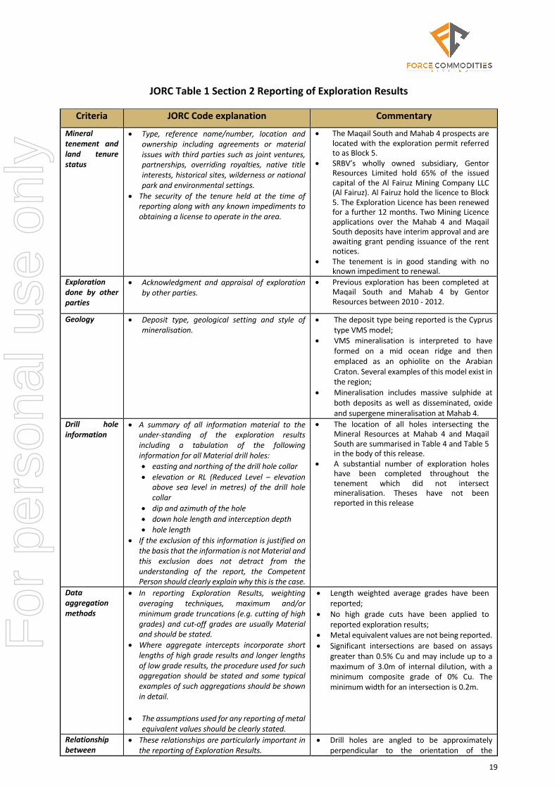
JORC Table 1 Section 2 Reporting of Exploration Results
Criteria JORC Code explanation Commentary
Mineral tenement and land tenure status
• Type, reference name/number, location and ownership including agreements or material issues with third parties such as joint ventures, partnerships, overriding royalties, native title interests, historical sites, wilderness or national park and environmental settings.
• The security of the tenure held at the time of reporting along with any known impediments to obtaining a license to operate in the area.
• The Maqail South and Mahab 4 prospects are located with the exploration permit referred to as Block 5.
• SRBV’s wholly owned subsidiary, Gentor Resources Limited hold 65% of the issued capital of the Al Fairuz Mining Company LLC (Al Fairuz). Al Fairuz hold the licence to Block 5. The Exploration Licence has been renewed for a further 12 months. Two Mining Licence applications over the Mahab 4 and Maqail South deposits have interim approval and are awaiting grant pending issuance of the rent notices.
• The tenement is in good standing with no known impediment to renewal.
Exploration done by other parties
• Acknowledgment and appraisal of exploration by other parties.
• Previous exploration has been completed at Maqail South and Mahab 4 by Gentor Resources between 2010 - 2012.
Geology • Deposit type, geological setting and style of mineralisation.
• The deposit type being reported is the Cyprus type VMS model;
• VMS mineralisation is interpreted to have formed on a mid ocean ridge and then emplaced as an ophiolite on the Arabian Craton. Several examples of this model exist in the region;
• Mineralisation includes massive sulphide at both deposits as well as disseminated, oxide and supergene mineralisation at Mahab 4.
Drill hole information
• A summary of all information material to the under-standing of the exploration results including a tabulation of the following information for all Material drill holes: • easting and northing of the drill hole collar • elevation or RL (Reduced Level – elevation
above sea level in metres) of the drill hole collar
• dip and azimuth of the hole • down hole length and interception depth • hole length
• If the exclusion of this information is justified on the basis that the information is not Material and this exclusion does not detract from the understanding of the report, the Competent Person should clearly explain why this is the case.
• The location of all holes intersecting the Mineral Resources at Mahab 4 and Maqail South are summarised in Table 4 and Table 5 in the body of this release.
• A substantial number of exploration holes have been completed throughout the tenement which did not intersect mineralisation. Theses have not been reported in this release
Data aggregation methods
• In reporting Exploration Results, weighting averaging techniques, maximum and/or minimum grade truncations (e.g. cutting of high grades) and cut-off grades are usually Material and should be stated.
• Where aggregate intercepts incorporate short lengths of high grade results and longer lengths of low grade results, the procedure used for such aggregation should be stated and some typical examples of such aggregations should be shown in detail.
• The assumptions used for any reporting of metal equivalent values should be clearly stated.
• Length weighted average grades have been reported;
• No high grade cuts have been applied to reported exploration results;
• Metal equivalent values are not being reported. • Significant intersections are based on assays
greater than 0.5% Cu and may include up to a maximum of 3.0m of internal dilution, with a minimum composite grade of 0% Cu. The minimum width for an intersection is 0.2m.
Relationship between
• These relationships are particularly important in the reporting of Exploration Results.
• Drill holes are angled to be approximately perpendicular to the orientation of the
For
per
sona
l use
onl
y

20
Criteria JORC Code explanation Commentary
mineralisation widths and intercept lengths
• If the geometry of the mineralisation with respect to the drill hole angle is known, its nature should be reported.
• If it is not known and only the down hole lengths are reported, there should be a clear statement to this effect (e.g.’down hole length, true width not known’).
mineralised trend; • Down hole intervals have been reported and
generally represent 60% to 100% of the true width.
Diagrams • Appropriate maps and sections (with scales) and tabulations of intercepts should be included for any significant discovery being reported. These should include, but not be limited to a plan view of drill hole collar locations and appropriate sectional views.
• Relevant diagrams and maps have been included in the main body of the release.
Balanced Reporting
• Accuracy and quality of surveys used to locate drill holes (collar and down-hole surveys), trenches, mine workings and other locations used in Mineral Resource estimation.
• Where comprehensive reporting of all Exploration Results is not practicable, representative reporting of both low and high grades and/or widths should be practiced to avoid misleading reporting of Exploration Results.
• Results have been reported for all drilling which intersected the Mineral Resources;
• The location of other exploration drill holes is shown in the diagrams within the body of the report.
Other substantive exploration data
• Other exploration data, if meaningful and material, should be reported including (but not limited to): geological observations; geophysical survey results; geochemical survey results; bulk samples - size and method of treatment; metallurgical test results; bulk density, groundwater, geotechnical and rock characteristics; potential deleterious or contaminating substances.
• Regional exploration programs have been conducted including geophysical surveys and surface geochemical surveys.
Further work • The nature and scale of planned further work (e.g. tests for lateral extensions or depth extensions or large- scale step-out drilling).
• Diagrams clearly highlighting the areas of possible extensions, including the main geological interpretations and future drilling areas, provided this information is not commercially sensitive.
• Evaluation work is planned to understand the economic potential of the deposits and to determine what additional exploration is warranted at the deposit.
For
per
sona
l use
onl
y

21
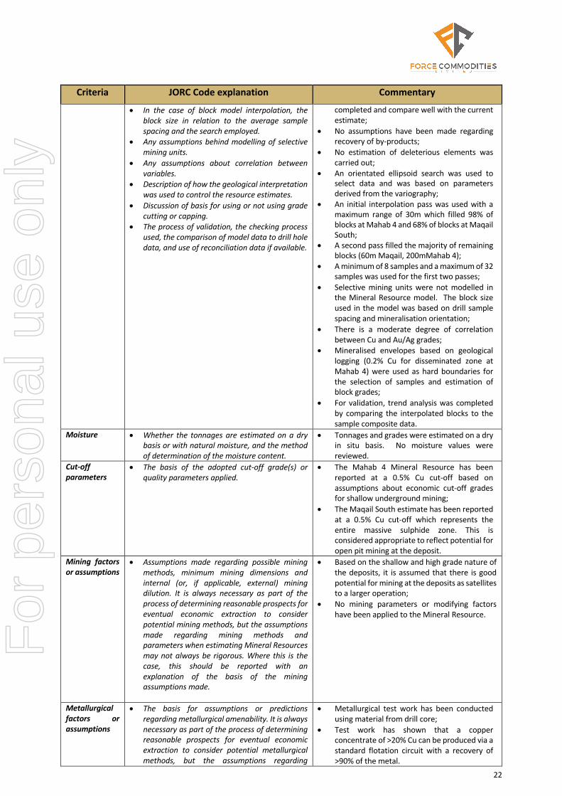
JORC Table 1 Section 3 Estimation and Reporting of Mineral Resources
Criteria JORC Code explanation Commentary
Database integrity
• Measures taken to ensure that data has not been corrupted by, for example, transcription or keying errors, between its initial collection and its use for Mineral Resource estimation purposes.
• Data validation procedures used.
• Data used for the Maqail South resource estimate is stored in a Microsoft Access database that is maintained by Savannah Resources. Data is loaded via fixed format templates that are populated by site geologists.
• Data is validated by visual inspection and data base queries to check integrity of hole depths against spatial information.
Site visits • Comment on any site visits undertaken by the Competent Person and the outcome of those visits.
• If no site visits have been undertaken indicate why this is the case.
• A site visit was undertaken by the Competent Person in May 2017;
• The site visit verified the extent of exploration activities. Drill collars from previous drilling were located and it was confirmed that no obvious impediments to future project exploration or development were present.
Geological interpretation
• Confidence in (or conversely, the uncertainty of) the geological interpretation of the mineral deposit.
• Nature of the data used and of any assumptions made.
• The effect, if any, of alternative interpretations on Mineral Resource estimation.
• The use of geology in guiding and controlling Mineral Resource estimation.
• The factors affecting continuity both of grade and geology.
• The confidence in the geological interpretation is considered to be high, with continuous mineralised structures defined by good quality drilling;
• The geological model is based on geological logging from diamond core drilling and from surface geological mapping. The geological model is well established for the formation of VMS mineralisation in the region.
• Mineralisation occurs on the contact between the Geotimes and Lasail basalts and the position of this contact has been used to guide the interpretation of the resource geometry.
Dimensions • The extent and variability of the Mineral
Resource expressed as length (along strike or otherwise), plan width, and depth below surface to the upper and lower limits of the Mineral Resource.
• Maqail South is a shallowly dipping lens of massive sulphide that is 100m long and 100m wide and up to 20m thick. Mineralisation is located from 50m below surface to a depth of 100m.
• Mahab 4 is a steeply dipping lens of massive sulphide that is 300m long and 10-30m wide with a dip extent of 150m. Mineralisation is located from surface to a depth of 200m
Estimation and modelling techniques
• The nature and appropriateness of the estimation technique(s) applied and key assumptions, including treatment of extreme grade values, domaining, interpolation parameters and maximum distance of extrapolation from data points. If a computer assisted estimation method was chosen include a description of computer software and parameters used.
• The availability of check estimates, previous estimates and/or mine production records and whether the Mineral Resource estimate takes appropriate account of such data.
• The assumptions made regarding recovery of by-products.
• Estimation of deleterious elements or other non-grade variables of economic significance (eg sulphur for acid mine drainage characterisation).
• Using parameters derived from modelled variograms, Ordinary Kriging (OK) was used to estimate average block grades for Cu, Au, Ag, Zn, S, Fe and SG;
• Surpac software was used for the estimation; • In the Mahab 4 estimate High grade cuts were
applied to a small number of Cu (14% in MS) and Au values (2.5g/t in oxide) in 1m composite data;
• No high grade cuts were applied to the Maqail South estimate;
• The parent block dimensions used in the Mahab 4 model were 20m x 10m x 10m and were selected to be slightly less than the average drill spacing and appropriate to the shape and orientation of the mineralisation.;
• The parent block dimensions used in the Maqail South model were 20m x 20m x 5m;
• Previous resource estimates have been
For
per
sona
l use
onl
y
22
Criteria JORC Code explanation Commentary
• In the case of block model interpolation, the block size in relation to the average sample spacing and the search employed.
• Any assumptions behind modelling of selective mining units.
• Any assumptions about correlation between variables.
• Description of how the geological interpretation was used to control the resource estimates.
• Discussion of basis for using or not using grade cutting or capping.
• The process of validation, the checking process used, the comparison of model data to drill hole data, and use of reconciliation data if available.
completed and compare well with the current estimate;
• No assumptions have been made regarding recovery of by-products;
• No estimation of deleterious elements was carried out;
• An orientated ellipsoid search was used to select data and was based on parameters derived from the variography;
• An initial interpolation pass was used with a maximum range of 30m which filled 98% of blocks at Mahab 4 and 68% of blocks at Maqail South;
• A second pass filled the majority of remaining blocks (60m Maqail, 200mMahab 4);
• A minimum of 8 samples and a maximum of 32 samples was used for the first two passes;
• Selective mining units were not modelled in the Mineral Resource model. The block size used in the model was based on drill sample spacing and mineralisation orientation;
• There is a moderate degree of correlation between Cu and Au/Ag grades;
• Mineralised envelopes based on geological logging (0.2% Cu for disseminated zone at Mahab 4) were used as hard boundaries for the selection of samples and estimation of block grades;
• For validation, trend analysis was completed by comparing the interpolated blocks to the sample composite data.
Moisture • Whether the tonnages are estimated on a dry basis or with natural moisture, and the method of determination of the moisture content.
• Tonnages and grades were estimated on a dry in situ basis. No moisture values were reviewed.
Cut-off parameters
• The basis of the adopted cut-off grade(s) or quality parameters applied.
• The Mahab 4 Mineral Resource has been reported at a 0.5% Cu cut-off based on assumptions about economic cut-off grades for shallow underground mining;
• The Maqail South estimate has been reported at a 0.5% Cu cut-off which represents the entire massive sulphide zone. This is considered appropriate to reflect potential for open pit mining at the deposit.
Mining factors or assumptions
• Assumptions made regarding possible mining methods, minimum mining dimensions and internal (or, if applicable, external) mining dilution. It is always necessary as part of the process of determining reasonable prospects for eventual economic extraction to consider potential mining methods, but the assumptions made regarding mining methods and parameters when estimating Mineral Resources may not always be rigorous. Where this is the case, this should be reported with an explanation of the basis of the mining assumptions made.
• Based on the shallow and high grade nature of the deposits, it is assumed that there is good potential for mining at the deposits as satellites to a larger operation;
• No mining parameters or modifying factors have been applied to the Mineral Resource.
Metallurgical factors or assumptions
• The basis for assumptions or predictions regarding metallurgical amenability. It is always necessary as part of the process of determining reasonable prospects for eventual economic extraction to consider potential metallurgical methods, but the assumptions regarding
• Metallurgical test work has been conducted using material from drill core;
• Test work has shown that a copper concentrate of >20% Cu can be produced via a standard flotation circuit with a recovery of >90% of the metal.
For
per
sona
l use
onl
y
23
Criteria JORC Code explanation Commentary
metallurgical treatment processes and parameters made when reporting Mineral Resources may not always be rigorous. Where this is the case, this should be reported with an explanation of the basis of the metallurgical assumptions made.
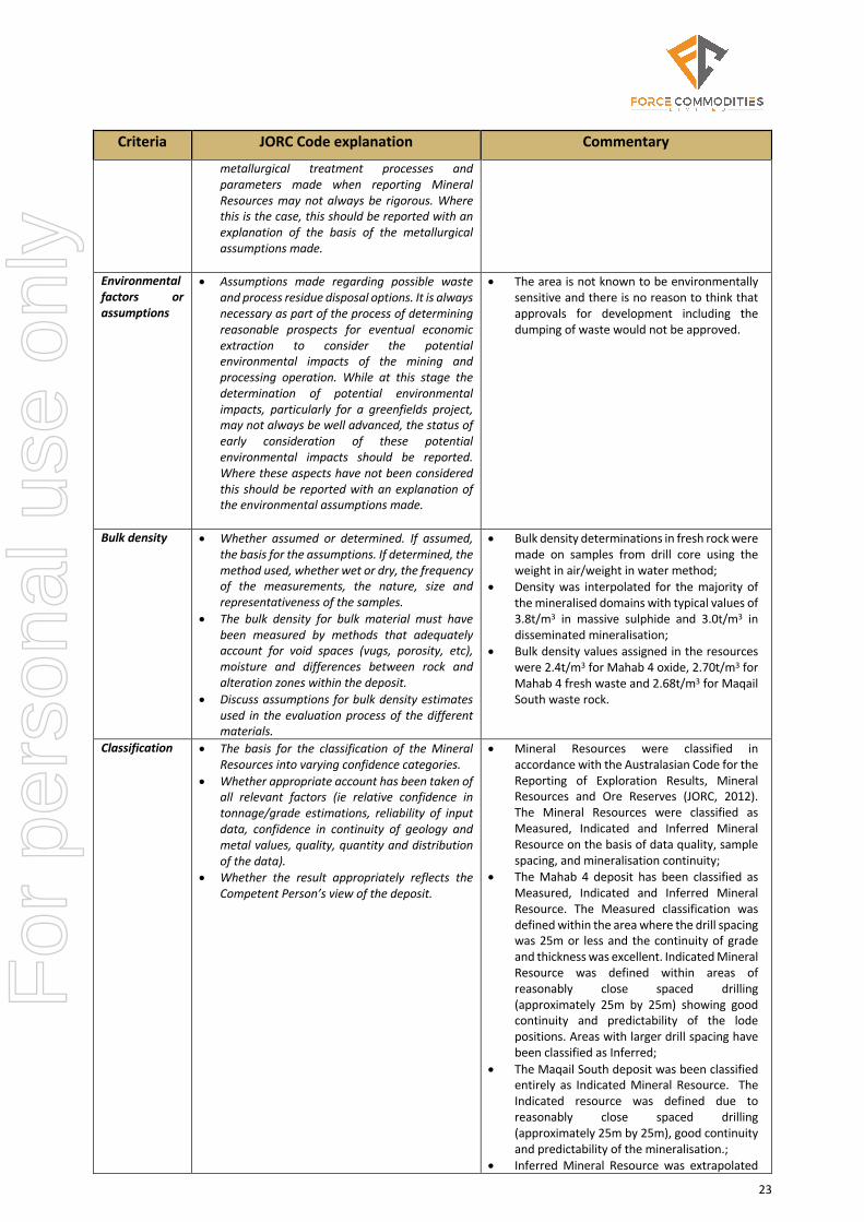
Environmental factors or assumptions
• Assumptions made regarding possible waste and process residue disposal options. It is always necessary as part of the process of determining reasonable prospects for eventual economic extraction to consider the potential environmental impacts of the mining and processing operation. While at this stage the determination of potential environmental impacts, particularly for a greenfields project, may not always be well advanced, the status of early consideration of these potential environmental impacts should be reported. Where these aspects have not been considered this should be reported with an explanation of the environmental assumptions made.
• The area is not known to be environmentally sensitive and there is no reason to think that approvals for development including the dumping of waste would not be approved.
Bulk density • Whether assumed or determined. If assumed, the basis for the assumptions. If determined, the method used, whether wet or dry, the frequency of the measurements, the nature, size and representativeness of the samples.
• The bulk density for bulk material must have been measured by methods that adequately account for void spaces (vugs, porosity, etc), moisture and differences between rock and alteration zones within the deposit.
• Discuss assumptions for bulk density estimates used in the evaluation process of the different materials.
• Bulk density determinations in fresh rock were made on samples from drill core using the weight in air/weight in water method;
• Density was interpolated for the majority of the mineralised domains with typical values of 3.8t/m3 in massive sulphide and 3.0t/m3 in disseminated mineralisation;
• Bulk density values assigned in the resources were 2.4t/m3 for Mahab 4 oxide, 2.70t/m3 for Mahab 4 fresh waste and 2.68t/m3 for Maqail South waste rock.
Classification • The basis for the classification of the Mineral Resources into varying confidence categories.
• Whether appropriate account has been taken of all relevant factors (ie relative confidence in tonnage/grade estimations, reliability of input data, confidence in continuity of geology and metal values, quality, quantity and distribution of the data).
• Whether the result appropriately reflects the Competent Person’s view of the deposit.
• Mineral Resources were classified in accordance with the Australasian Code for the Reporting of Exploration Results, Mineral Resources and Ore Reserves (JORC, 2012). The Mineral Resources were classified as Measured, Indicated and Inferred Mineral Resource on the basis of data quality, sample spacing, and mineralisation continuity;
• The Mahab 4 deposit has been classified as Measured, Indicated and Inferred Mineral Resource. The Measured classification was defined within the area where the drill spacing was 25m or less and the continuity of grade and thickness was excellent. Indicated Mineral Resource was defined within areas of reasonably close spaced drilling (approximately 25m by 25m) showing good continuity and predictability of the lode positions. Areas with larger drill spacing have been classified as Inferred;
• The Maqail South deposit was been classified entirely as Indicated Mineral Resource. The Indicated resource was defined due to reasonably close spaced drilling (approximately 25m by 25m), good continuity and predictability of the mineralisation.;
• Inferred Mineral Resource was extrapolated
For
per
sona
l use
onl
y

24
Criteria JORC Code explanation Commentary
up to 60m past drill hole intersections; • The definition of mineralised zones is based
on sound geological understanding producing a robust model of mineralised domains;
• The Mineral Resource estimate appropriately reflects the view of the Competent Person.
Audits or reviews
• The results of any audits or reviews of Mineral Resource estimates.
• The resource has been audited and reviewed by an independent geological consultant with relevant and appropriate experience.
Discussion of relative accuracy/ confidence
• Where appropriate a statement of the relative accuracy and confidence level in the Mineral Resource estimate using an approach or procedure deemed appropriate by the Competent Person. For example, the application of statistical or geostatistical procedures to quantify the relative accuracy of the resource within stated confidence limits, or, if such an approach is not deemed appropriate, a qualitative discussion of the factors that could affect the relative accuracy and confidence of the estimate.
• The statement should specify whether it relates to global or local estimates, and, if local, state the relevant tonnages, which should be relevant to technical and economic evaluation. Documentation should include assumptions made and the procedures used.
• These statements of relative accuracy and confidence of the estimate should be compared with production data, where available.
• The Mineral Resource estimates are considered to be reported with a high degree of confidence. The consistent mineralisation geometry and continuity is reflected in the Mineral Resource classification. The data quality is good and the drill holes have detailed logs produced by qualified geologists;
• The Mineral Resource statements relate to global estimates of tonnes and grade;
• The deposits have not previously been mined.
This announcement is authorised by Jess Oram, Non-Executive Chair
Contact:
Jess Oram, Non-Executive Chair Force Commodities Limited Tel: +61 (0) 8 6117 3860 Email: [email protected]
About Force Force is a base metals exploration and development focused company headquartered in Perth, Western Australia and is listed on the Australian Securities Exchange (ASX:4CE). Force is currently in voluntary suspension pending the reinstatement of its securities to trading on the official list of the ASX. Force went into voluntary suspension in January 2020, on a decision of the Board, to restructure and refinance the Company and to change the senior management of the Company following the failure of several business opportunities and the inability to raise further capital. Over the past 6 months Force has been undergoing a structured process to reinstate the Company’s securities to trading on the ASX including changing senior management, identifying new sources of capital. Force has steadily gained momentum during the restructure through the identification of a high-quality project for acquisition and appointments of high calibre senior professionals to its Board and Executive. The culmination of the relisting process is the injection of new funds (a process overseen by boutique corporate advisory firm 62 Capital) based on the acquisition of the high-quality Oman Copper Project.
For
per
sona
l use
onl
y
25
About Oman
The Sultanate of Oman is a modern Middle Eastern country with excellent infrastructure, low fuel costs and a favourable fiscal regime, excellent attributes to support potential mine development. Copper mining and smelting in the Sohar Region of Oman has a history dating back to the Bronze Age. Weathered, outcropping VMS deposits provided a major source of metal for early Bronze Age cultures in Mesopotamia. Copper metal continued to be sourced from the region right through the Middle Ages and during the rise of Islam. The similar geological character of the Semail Ophiolite in Oman to the Troodos Massif in Cyprus, stimulated the first round of modern mineral exploration and mining in the region in the 1950s and 1960s. Between the 1970s and 1990s the Oman Government sponsored international aid-orientated and commercial mining groups to conduct basic geological mapping and more focussed systematic mineral exploration for copper in the Semail Ophiolite Belt. This intense period of multinational exploration resulted in the discovery of more than 44 million tonnes of 1-2% copper which were sporadically mined and smelted within Oman. Exploration work in the late 1990’s by the Japanese International Cooperation Agency (JICA) led to the discovery of two mineralised districts: firstly, Hayl-al-Safal -- Rakah (17 million tonnes of 1.2% copper and 1.0g/t gold) and Ghuzayn where the drilling of geophysical anomalies resulted in the discovery of 14 million tonnes of 1.4% copper. Relatively little modern exploration has been carried out in Oman since the 1980’s and 1990’s. Therefore, recent exploration techniques developed to search for covered VMS deposits have not been applied widely. A new phase of copper exploration and mining commenced in the early 2000’s when a local Omani firm, Mawarid Mining commenced mining at Shinas, a deposit of 2Mt @ 2.0% Cu and a small cluster of bodies at Hatta with 1.5Mt @ 3.5% Cu. Mawarid are mining and trucking the ore some 80 kilometres south to the Lasail Beneficiation and Smelting Complex.
For
per
sona
l use
onl
y

26
Annexure A – Key Terms and Conditions of SPA
The material terms and conditions of the SPA between Force and Savannah are as follows:
(a) Acquisition: The Company will acquire 100% of the issued capital of SRBV (Sale Shares) from Savannah, free from any encumbrances (the Acquisition);
(b) Conditions Precedent: Settlement of the Acquisition (Settlement) is conditional upon satisfaction (or waiver) of the following conditions precedent on or before the date that is three months after execution of the SPA:
(i) the Company raising not less than AUD$1,500,000 and receiving the conditional approval of the ASX for the Company’s securities to reinstated to trading on the official list of the ASX (on terms acceptable to Force and Savannah);
(ii) the Company receiving written confirmation of the following:
(A) unencumbered legal and beneficial title to a 51% interest in Al Thuraya;
(B) a two-year extension to the second earn-in period under the Al Thuraya shareholders agreement which would enable the Company to acquire an additional 14% interest in Al Thuraya (such that it holds a 65% interest) upon an additional contribution of capital of US$825,000; and
(C) that the total amount of capital required to be expended by the Company for it to acquire the additional 14% interest in Al Thuraya under the extended earn-in period is US$825,000;
(iii) the Company satisfying itself of unencumbered legal and beneficial title to a 65% interest in Al Fairuz;
(iv) no event having occurred, or matter or thing having arisen prior to Settlement which has a material adverse effect in relation to a Savannah group member or the Company;
(v) the extinguishment of all intercompany debt owing to Savannah;
(vi) the Company’s auditors having signed their audit report on the audited consolidated accounts of the Company for the year ended 31 December 2019 and the Company having delivered a copy of the same to the Savannah;
(vii) the Company having obtained all necessary shareholder and regulatory approval required to complete the Acquisition as required by the ASX Listing Rules and the Corporations Act 2001 (Cth); and
(viii) Savannah, SAV BV, Gentor and the Mining Companies obtaining all necessary third-party approvals, consents or waivers to give effect to the Acquisition and to allow the parties to complete the sale of the Sale Shares.
(c) Consideration: In consideration for the Acquisition, the Company will issue Savannah, subject to shareholder approval, 50,000,000 Shares (Consideration Shares);
(d) Reimbursement: In addition to the Consideration and subject to Settlement occurring, the Company will reimburse Savannah AUD$3,500,000, being a portion of the loan owing to Gentor (a subsidiary of SRBV) in respect of historical expenditure at the Block 5 Project. This amount will be paid to Savannah in priority to Gentor out of annual profits generated from production at the Block 5 Project; and
For
per
sona
l use
onl
y

27
(e) Royalty: In addition to the Consideration and subject to Settlement occurring, the Company has agreed to pay Savannah an amount equivalent to a 1% net smelter return royalty from the Company’s respective portion of revenue generated from production at the Block 4 Project and Block 5 (being up to 65%).
The SPA contains such other terms and conditions considered standard for an agreement of its nature including restrictions on conduct before Settlement, representations and warranties and confidentiality provisions.
For
per
sona
l use
onl
y

![PETROLEUM DEVELOPMENT OMAN (PDO) [Elmech] Development Oman - PDO [Elmec… · Petroleum Development Oman L.L.C. ... Postal Address : P.O.BOX 505- PC 114- SULTANATE OF OMAN Is registered](https://static.fdocuments.us/doc/165x107/5ac633c57f8b9a5c558dcb76/petroleum-development-oman-pdo-elmech-development-oman-pdo-elmecpetroleum.jpg)