For personal use only - ASX...2014/04/02 · 2 Company Snapshot Name: Byron Energy Limited ASX...
42
Morgans Emerging Companies Conference Presentation April 2014 For personal use only
Transcript of For personal use only - ASX...2014/04/02 · 2 Company Snapshot Name: Byron Energy Limited ASX...

Morgans Emerging Companies Conference PresentationApril 2014
For
per
sona
l use
onl
y

2
Company Snapshot
Name: Byron Energy LimitedASX code: BYEIssued capital: 128m ordinary shares
37m options exercisable at $0.50 before 31/12/16
Market cap: $104m @ $0.81
Cash ~US$12m (as at 31/12/13)
First well: Byron Energy South Marsh Island 6 #1 Well (SM6#1)
Well timing: Expected spud date April 2014
Drilling rig: Spartan 202 Jackup Rig
Portfolio: 16 blocks in shallow water Gulf of Mexico, offshore Louisiana
Experience: Team has more than 20 year history of success drilling in the area
For
per
sona
l use
onl
y

3
Byron’s StrategyExperienced Team
• Maintain a small, highly motivated and experienced staff with a proven track record of success in the Gulf of Mexico.
Gulf of Mexico Specialists
• Focus on oil prospects in the shallow water of the highly prospective Gulf of Mexico• Take advantage of lower acreage competition associated with the post-Macondo
complex regulatory environment.
Geophysical Expertise and Focus
• As early adopters of advanced geophysical technologies we focus our exploration efforts on the structurally and stratigraphically complex areas associated with steep sided salt domes.
• Take advantage of barriers to entry for those who lack this highly specialised technical expertise.
For
per
sona
l use
onl
y

4
Byron’s Assets: Gulf of Mexico Lease Portfolio
For
per
sona
l use
onl
y

5
Blocks OwnedProperties Operator WI/NRI* (%)
South Marsh Island Block 6 Byron 100.00/81.25
South Marsh Island Block 70 Byron 100.00/81.25
South Marsh Island Block 71 Byron 100.00/81.25
Ship Shoal Block 180 Byron 100.00/81.25
West Delta Block 49 Byron 100.00/81.25
West Cameron Block 263 Byron 100.00/81.25
East Cameron Block 154 Byron 100.00/81.25
East Cameron Block 155 Byron 100.00/81.25
East Cameron Block 190 Byron 100.00/81.25
Properties Operator WI/NRI* (%)
Eugene Island Block 191 Byron 100.00/81.25
Eugene Island Block 210 Byron 100.00/81.25
Eugene Island Block 63 Byron 100.00/81.25
Eugene Island Block 76 Byron 100.00/81.25
Eugene Island Block 190 Byron 100.00/81.25
Grand Isle Block 63** Byron 100.00/81.25
Grand Isle Block 72** Byron 100.00/81.25
Grand Isle Block 73** Byron 100.00/81.25
Grand Isle Block 95 Byron 100.00/79.75
Vermilion Block 200 Byron 100.00/81.25* Working Interest (“WI”) and Net Revenue Interest (“NRI”)** Byron was high bidder on these blocks in March 2014 which are yet to be officially awarded to Byron.NOTE: None of Byron’s blocks currently has production or production facilities.
For
per
sona
l use
onl
y
6
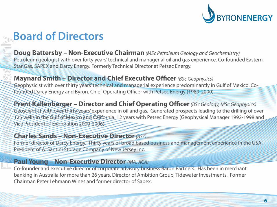
Board of DirectorsDoug Battersby – Non-Executive Chairman (MSc Petroleum Geology and Geochemistry)Petroleum geologist with over forty years’ technical and managerial oil and gas experience. Co-founded Eastern Star Gas, SAPEX and Darcy Energy. Formerly Technical Director at Petsec Energy.
Maynard Smith – Director and Chief Executive Officer (BSc Geophysics)Geophysicist with over thirty years’ technical and managerial experience predominantly in Gulf of Mexico. Co-founded Darcy Energy and Byron. Chief Operating Officer with Petsec Energy (1989-2000).
Prent Kallenberger – Director and Chief Operating Officer (BSc Geology, MSc Geophysics)Geoscientist with over thirty years’ experience in oil and gas. Generated prospects leading to the drilling of over 125 wells in the Gulf of Mexico and California. 12 years with Petsec Energy (Geophysical Manager 1992-1998 and Vice President of Exploration 2000-2006).
Charles Sands – Non-Executive Director (BSc)Former director of Darcy Energy. Thirty years of broad based business and management experience in the USA. President of A. Santini Storage Company of New Jersey Inc.
Paul Young – Non-Executive Director (MA, ACA)Co-founder and executive director of corporate advisory business Baron Partners. Has been in merchant banking in Australia for more than 26 years. Director of Ambition Group, Tidewater Investments. Former Chairman Peter Lehmann Wines and former director of Sapex.
For
per
sona
l use
onl
y

7
Operating Track Record• Wells initiated by Byron executives Doug Battersby, Maynard Smith and Prent
Kallenberger (prior to founding Byron) have produced 22 MMBbls of oil and 263 Bcf of gas since 1992.
• This equates to an average of over 3,000 barrels of oil per day and 36 million cubic feet of gas per day over 20 years.
• This production was achieved through 71 producing wells, which were drilled from 86 attempts (an 83% success rate).
• Peak production from wells initiated by Byron executives was approximately 9,000 barrels of oil per day and 100 million cubic feet of gas per day.
• The team focus exclusively on a 480km stretch of shallow water, offshore Louisiana in the Gulf of Mexico.
• The Byron team use state of the art geophysical interpretation to acquire blocks and develop prospects, from 3D seismic in the 1990s to Reverse Time Migration in the present.
For
per
sona
l use
onl
y
8
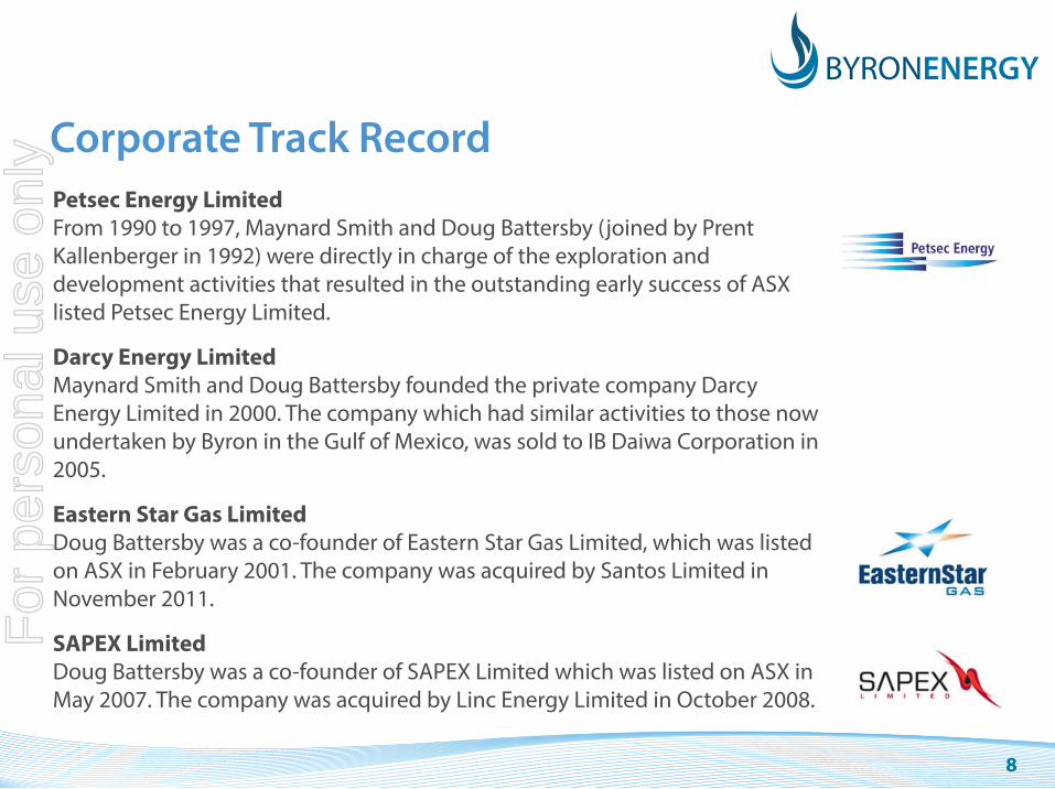
Corporate Track RecordPetsec Energy LimitedFrom 1990 to 1997, Maynard Smith and Doug Battersby (joined by Prent Kallenberger in 1992) were directly in charge of the exploration and development activities that resulted in the outstanding early success of ASX listed Petsec Energy Limited.
Darcy Energy LimitedMaynard Smith and Doug Battersby founded the private company Darcy Energy Limited in 2000. The company which had similar activities to those now undertaken by Byron in the Gulf of Mexico, was sold to IB Daiwa Corporation in 2005.
Eastern Star Gas LimitedDoug Battersby was a co-founder of Eastern Star Gas Limited, which was listed on ASX in February 2001. The company was acquired by Santos Limited in November 2011.
SAPEX LimitedDoug Battersby was a co-founder of SAPEX Limited which was listed on ASX in May 2007. The company was acquired by Linc Energy Limited in October 2008.
For
per
sona
l use
onl
y

9
South Marsh Island 6 Salt Dome Project
Operator: Byron Energy, Inc
Working Interest 100%
Net Revenue Interest 81.25%
Acquired: OCS Sale 210 March 2010
$321,696
Water Depth: 65’
Block Production: 18.5 mmbo + 37 BCF
For
per
sona
l use
onl
y
10
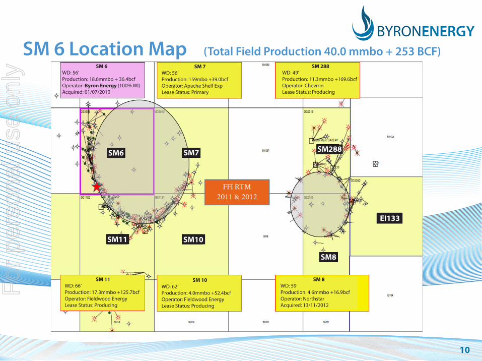
SM 6 Location Map (Total Field Production 40.0 mmbo + 253 BCF) SM 6
WD: 56’Production: 18.6mmbo + 36.4bcfOperator: Byron Energy (100% WI)Acquired: 01/07/2010
SM 7WD: 56’Production: 159mbo +39.0bcfOperator: Apache Shelf ExpLease Status: Primary
SM 288WD: 49’Production: 11.3mmbo +169.6bcfOperator: ChevronLease Status: Producing
SM6 SM7 SM288
EI133
SM8
SM10SM11
SM 11WD: 66’Production: 17.3mmbo +125.7bcfOperator: Fieldwood EnergyLease Status: Producing
SM 10WD: 62’Production: 4.0mmbo +52.4bcfOperator: Fieldwood EnergyLease Status: Producing
SM 8WD: 59’Production: 4.6mmbo +16.9bcfOperator: NorthstarAcquired: 13/11/2012
For
per
sona
l use
onl
y

11
SM 6 - From Map to RigPermitting Process Started March 2013
A 12 Month JourneyNow Ready to Drill
For
per
sona
l use
onl
y
12
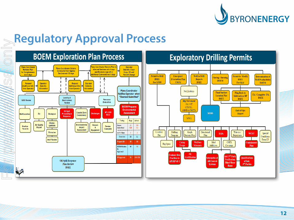
Regulatory Approval Process
For
per
sona
l use
onl
y
13
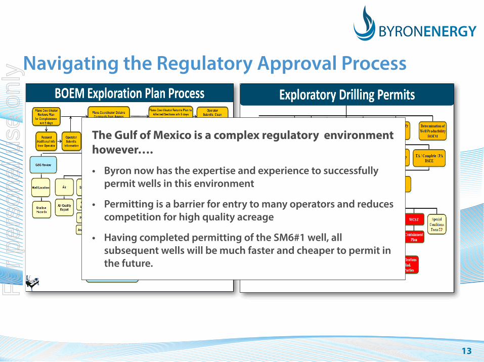
Navigating the Regulatory Approval Process
The Gulf of Mexico is a complex regulatory environment however….
• Byron now has the expertise and experience to successfully permit wells in this environment
• Permitting is a barrier for entry to many operators and reduces competition for high quality acreage
• Having completed permitting of the SM6#1 well, all subsequent wells will be much faster and cheaper to permit in the future.
For
per
sona
l use
onl
y

14
Geological & Geophysical
6 3D Surveys
71 3D “Data Types”
1562 Square Miles of Data Types
225 Wells
1321 Old MMS Well Records
214* Horizons
119 Faults
375* Contour Files
200 Grid Files
291 Sand Tops
35 Stratigraphic Zones
92 Planimeter Files
Countless: Man-Hours in front of a computer
* And Counting…
South Marsh Island 6 - By the NumbersPermitting & Operations
444 Pages: Oil Spill Response Plan
125 Pages: EP - Confidential Version
69 Pages EP – Public Version
297 Pages: APD
22 Pages: Temporary Caisson Permit
13 Volumes: SEMS
1 Worst Case Discharge Calculation
1 Shallow Hazard Survey
51* Master Service Agreements
4* Master Time Charter Agreements
5* Master Purchase Order
1 Master Construction Agreement
1 Drilling Contract
37* Credit Applications
18* Misc. Government Regulatory Applications
1 Approved Exploration Plan
1 Approved Temporary Caisson Permit
1 Approved Application for Permit to drill
* And Counting...
For
per
sona
l use
onl
y
15
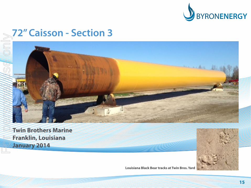
72” Caisson - Section 3
Twin Brothers MarineFranklin, LouisianaJanuary 2014
Louisiana Black Bear tracks at Twin Bros. Yard
For
per
sona
l use
onl
y

16
72” Caisson - Installation
South Marsh Island 6 LeaseOffshore LouisianaFebruary 2014F
or p
erso
nal u
se o
nly
17
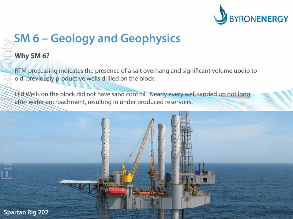
SM 6 – Geology and GeophysicsWhy SM 6?
RTM processing indicates the presence of a salt overhang and significant volume updip to old, previously productive wells drilled on the block.
Old Wells on the block did not have sand control. Nearly every well sanded up not long after water encroachment, resulting in under produced reservoirs.
Spartan Rig 202
For
per
sona
l use
onl
y
18
Anisotropic Reverse Time Migration – State of PlayFull Wave Equation Migration• A two way WEM migration (from both the source and the receiver)• Handles complex velocity fields (like salt bodies), images steep dips (> 70 degrees),
yields “accurate” amplitudes• Coupled with new Anisotropic sediment and “dirty” salt velocity modeling, the results are
excellent• Higher frequencies are being achieved at lower costs – improved resolution
Downsides• Lower frequency data, a little noisy• Still expensive, but costs are decreasing as computing power increases
RTM on the GOM shelf is increasing• New players from deep water – some with legacy acreage, some seeking new projects
with RTM possibilities• New Full Azimuth Acquisition – spec and proprietary
Fairfield Nodal, WesternGeco and Others• RTM workflows are being refined to cut costs and improve quality• Byron has been fortunate that two contractors have used leased acreage as “Labs” for
RTM processing
For
per
sona
l use
onl
y

19
Imaging Evolution - SM 6
1990s Vintage 2D
Late 1990s 3D Pre-Stack Time Migration
Imaging Evolution - SM 6 BYRON ENERGY INC. HAS LICENSED THIS DATA FROM FAIRFIELDNODAL. FAIRFIELDNODAL IS THE OWNER OF THIS DATA. FAIRFIELDNODAL MAKES NO REPRESENTATION OR WARRANTY OF ANY KIND OR DESCRIPTION, EXPRESS OR IMPLIED, WITH RESPECT TO THE DATA EXCEPT THAT IT OWNS OR WILL OWN THE DATA AND MAY LICENSE IT TO LI-CENSEE PURSUANT TO A MASTER LICENSE AGREEMENT WITHOUT VIOLATING THE RIGHTS OF ANY THIRD PARTY. ALL DATA DELIVERED TO LICENSEE “AS IS, WHERE IS” . ANY USE WHICH THE LICENSEE MAKES OF THE DATA AND ANY AC-TION WHICH THE LICENSEE TAKES BASED ON THE DATA WILL BE AT THE LICENSEE’S SOLE RISK, EXPENSE AND LIABIL-ITY AND LICESNSEE WILL NOT HAVE ANY CLAIM AGAINST DATA OWNER BY REASON OF ANY SUCH USE OR ACTION.
BYRON ENERGY INC. HAS LICENSED THIS DATA FROM TGS. TGS MAKES NO REPRESENTATION OR WARRANTY, EXPRESS OR IMPLIED, OF ANY KIND OR DESCRIPTION WITH RESPECT THERETO, INCLUDING ANY WARRANTY REGARDING THE MERCHANT-ABILITY, QUALITY OR RELIABILITY OF THE SEIMIC MATERIAL OR ITS FITNESS FOR ANY PARTICULAR PURPOSE.
TD for SM6 #1
Future Deep Targets
TD for SM6 #1
Future Deep Targets
For
per
sona
l use
onl
y

20
Late 1990s 3D Pre-Stack Time MigrationLine 4392
2011 Anisotropic Reverse Time MigrationLine 4392
Proposed Well #1
Proposed Well #1
BYRON ENERGY INC. HAS LICENSED THIS DATA FROM FAIRFIELDNODAL. FAIRFIELDNODAL IS THE OWNER OF THIS DATA. FAIRFIELDNODAL MAKES NO REPRESENTATION OR WARRANTY OF ANY KIND OR DESCRIPTION, EXPRESS OR IMPLIED, WITH RESPECT TO THE DATA EXCEPT THAT IT OWNS OR WILL OWN THE DATA AND MAY LICENSE IT TO LICENSEE PURSUANT TO A MASTER LICENSE AGREEMENT WITHOUT VIOLATING THE RIGHTS OF ANY THIRD PARTY. ALL DATA DELIVERED TO LICENSEE “AS IS, WHERE IS”. ANY USE WHICH THE LICENSEE MAKES OF THE DATA AND ANY ACTION WHICH THE LICENSEE TAKES BASED ON THE DATA WILL BE AT THE LICENSEE’S SOLE RISK, EXPENSE AND LIABILITY AND LICESNSEE WILL NOT HAVE ANY CLAIM AGAINST DATA OWNER BY REASON OF ANY SUCH USE OR ACTION.
TD for SM6 #1
Future Deep Targets TD for SM6 #1
Future Deep Targets
For
per
sona
l use
onl
y

21
ConventionalDepth Migration -
XLine 4385
Anisotropic Reverse Time Migration (ARTM) - XLine 4385
BYRON ENERGY INC. HAS LICENSED THIS DATA FROM FAIRFIELDNODAL. FAIRFIELD-NODAL IS THE OWNER OF THIS DATA. FAIRFIELDNODAL MAKES NO REPRESENTATION OR WARRANTY OF ANY KIND OR DESCRIPTION, EXPRESS OR IMPLIED, WITH RESPECT TO THE DATA EXCEPT THAT IT OWNS OR WILL OWN THE DATA AND MAY LICENSE IT TO LICENSEE PURSUANT TO A MASTER LICENSE AGREEMENT WITHOUT VIOLATING THE RIGHTS OF ANY THIRD PARTY. ALL DATA DELIVERED TO LICENSEE “AS IS, WHERE IS”. ANY USE WHICH THE LICENSEE MAKES OF THE DATA AND ANY ACTION WHICH THE LICENSEE TAKES BASED ON THE DATA WILL BE AT THE LICENSEE’S SOLE RISK, EXPENSE AND LIABILITY AND LICESNSEE WILL NOT HAVE ANY CLAIM AGAINST DATA OWNER BY REASON OF ANY SUCH USE OR ACTION.
TD for SM6 #1
Future Deep Targets
TD for SM6 #1
Future Deep Targets
For
per
sona
l use
onl
y

22
Byron Energy SM6 #1“Well P Twin”
BYRON ENERGY INC. HAS LICENSED THIS DATA FROM FAIRFIELDNODAL. FAIRFIELDNODAL IS THE OWNER OF THIS DATA. FAIRFIELDNODAL MAKES NO REPRESENTATION OR WARRANTY OF ANY KIND OR DESCRIPTION, EXPRESS OR IMPLIED, WITH RESPECT TO THE DATA EXCEPT THAT IT OWNS OR WILL OWN THE DATA AND MAY LICENSE IT TO LICENSEE PURSU-ANT TO A MASTER LICENSE AGREEMENT WITHOUT VIOLATING THE RIGHTS OF ANY THIRD PARTY. ALL DATA DELIVERED TO LICENSEE “AS IS, WHERE IS”. ANY USE WHICH THE LICENSEE MAKES OF THE DATA AND ANY ACTION WHICH THE LICENSEE TAKES BASED ON THE DATA WILL BE AT THE LICENSEE’S SOLE RISK, EXPENSE AND LIABILITY AND LICESNSEE WILL NOT HAVE ANY CLAIM AGAINST DATA OWNER BY REASON OF ANY SUCH USE OR ACTION.
For
per
sona
l use
onl
y

23
Primary Geologic Targets - SM6 #1 Well
Byron Energy SM6 #1
B11
F Sands
G20 Sand
I Sands
Multipleindependent
reservoir targets infirst well
Deep targets for future well
TD for SM6#1 Well
H Sands
For
per
sona
l use
onl
y
24
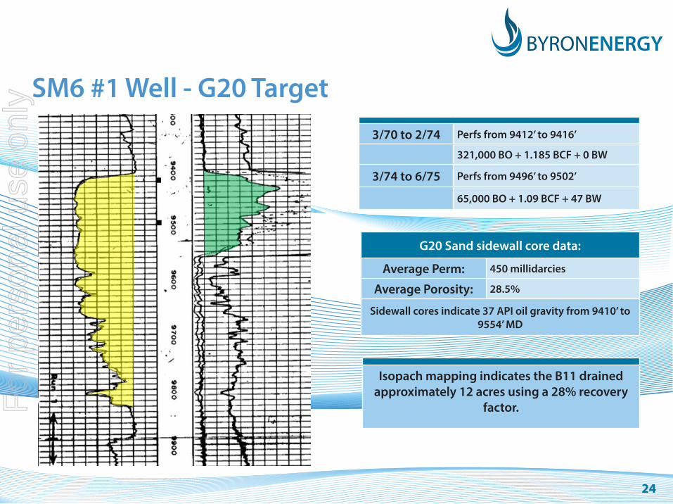
SM6 #1 Well - G20 Target3/70 to 2/74 Perfs from 9412’ to 9416’
321,000 BO + 1.185 BCF + 0 BW
3/74 to 6/75 Perfs from 9496’ to 9502’
65,000 BO + 1.09 BCF + 47 BW
G20 Sand sidewall core data:
Average Perm: 450 millidarcies
Average Porosity: 28.5%
Sidewall cores indicate 37 API oil gravity from 9410’ to 9554’ MD
Isopach mapping indicates the B11 drained approximately 12 acres using a 28% recovery
factor. For
per
sona
l use
onl
y

25
For
per
sona
l use
onl
y

26
SM 6 B11 385 mbo + 2.2 bcf + 47 bw
SM 6 B52 ST2G20 Oil – not Perf’d
For
per
sona
l use
onl
y

27
Eugene Island 63/76 Salt Dome Project
Operator: Byron Energy, Inc
Working Interest 100%
Net Revenue Interest 81.25%
Acquired: OCS Sale 227 March 2013
$172,200 Each Block
Water Depth: 20’
Combined Block Production:
1.5 mmbo + 74 BCF
For
per
sona
l use
onl
y
28
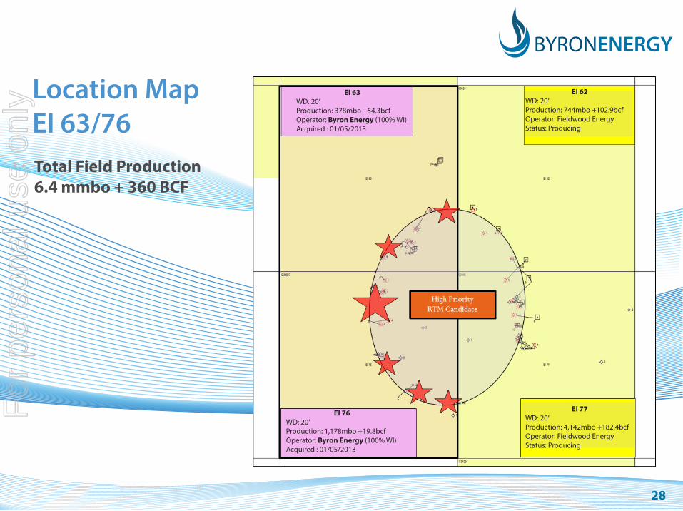
Location MapEI 63/76Total Field Production 6.4 mmbo + 360 BCF
EI 76WD: 20’Production: 1,178mbo +19.8bcfOperator: Byron Energy (100% WI)Acquired : 01/05/2013
EI 77WD: 20’Production: 4,142mbo +182.4bcfOperator: Fieldwood Energy Status: Producing
EI 63WD: 20’Production: 378mbo +54.3bcfOperator: Byron Energy (100% WI)Acquired : 01/05/2013
EI 62WD: 20’Production: 744mbo +102.9bcfOperator: Fieldwood EnergyStatus: Producing
For
per
sona
l use
onl
y

29
EI 63/76 Salt Dome ProjectWhy EI 63/76?
• The EI 63 Dome has been a prolific oil and gas producer beginning in 1957 6.4 mmbo + 360 bcf
• Preliminary 3D interpretation indicates at least four areas where future wells can be drilled for new or overlooked reserves
Reserve potential appears to be robust with good liquid expectations• Although deeper wells are required, the stratigraphic section is not over pressured
and water depth is only 25’
• EI 63/76 dome has a salt overhang around the entire dome, which makes it an ideal candidate for RTM Processing
For
per
sona
l use
onl
y

30
EI77 Hunt #10 Type Log – with Cumulative Sand Production from Dome
For
per
sona
l use
onl
y

31
Nth-Sth Arb. LineEI 76 #1 EI 62 #3
BYRON ENERGY INC. HAS LICENSED THIS DATA FROM WESTERNGECO. THIS DATA IS OWNED BY AND IS A TRADE SECRET OF WESTERNGECO AND PRTECTED BY U.S. AND INTERNATINAL COPYRIGHTS. THE USE OF THIS DATA IS RESTRICTED TO CAOMPANIES HLDING A VALID USE LICENSE FROM WESTERNGECO AND IS SUBJECT TO THE CONFIDENTIALITY TERMS OF THAT LICENSE. THE DATA MAY NOT BE DISCLOSED OR TRANS-FERRED EXCEPT AS EXPRESSLY AUTHORIZED IN THE LICENSE. ANY UNAUTHORIZED DISCLOUSRE, USE OR REPRODUCTION OF THIS DATA IS STRICTLY PROHIBITED.
For
per
sona
l use
onl
y
32
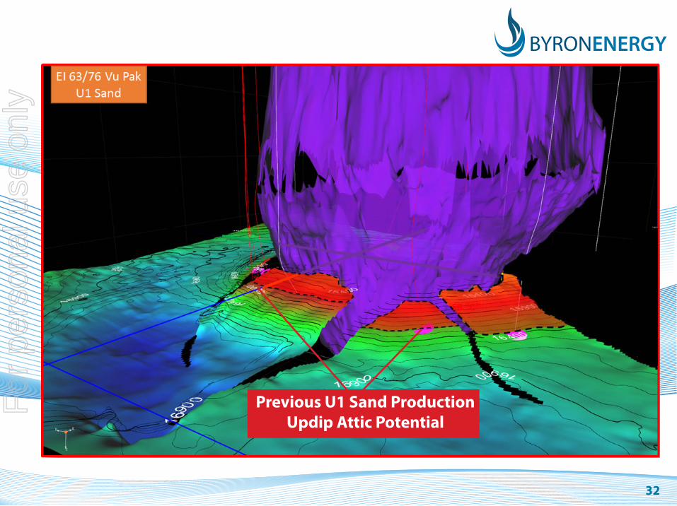
Previous U1 Sand ProductionUpdip Attic Potential
For
per
sona
l use
onl
y

33
South Marsh Island 70/71 Salt Dome Project
Operator: Byron Energy, Inc
Working Interest 100%
Net Revenue Interest 81.25%
Acquired: OCS Sale 222 March 2012
$166,620 Each Block
Water Depth: 131’
Combined Block Production:
3.9 mmbo + 10 BCF
For
per
sona
l use
onl
y

34
Location MapSM 70/71Total Field Production 113 mmbo + 348 BCF
SMI 70WD: 131’Production: 2mbo +.7bcfOperator: Byron Energy (100% WI)Acquired : 01/08/2012
SMI 58WD: 125’Production: 35.2mmbo +265.2bcfOperator: Fieldwood EnLease Status: Producing
SMI 69WD: 125’Production: 19.5mmbo +22.6bcfOperator: Ankor EnLease Status: Producing
SMI 73WD: 131’Production: 45.2mmbo +35.3bcfOperator: Ankor EnLease Status: Producing
SMI 72WD: 131’Production: 9.8mmbo +8.6bcfOperator: Ankor EnLease Status: Producing
SMI 71WD: 131’Production: 3.9mmbo +9.6bcfOperator: Byron Energy (100% WI)Acquired : 01/08/2012
SMI 57WD: 125’Production: 849mbo +14.5bcfOperator: Castex OffStatus: Primary
For
per
sona
l use
onl
y
35
South Marsh Island 70/71 Salt Dome ProjectWhy SM 70/71?
• SM 70 Dome has prolific oil production above 7500’ TVD:
75 mmbo
• Preliminary RTM data has defined the structural setting for previously productive sands around the dome.
• RTM data shows prospective areas of attic updip to production on both SM70 and SM71.
• Prospect depths are 5500’ TVD to 7000’ TVD with large oil potential.
• Because of the stratigraphic nature (and risk) of these opportunities Byron has solicited bids for a Full Waveform Inversion product to further enhance the ability to map these sand bodies as they pinch out up dip.
For
per
sona
l use
onl
y
36
SM 70/71 - Full Waveform InversionProduce 3D Seismic attributes at the reservoir level:
• Acoustic and elastic impedance volumes
• Porosity and pore pressure analysis
• Various geophysical attributes
Poisson’s Ratio
AVO
• FWI uses the full 2-way wave equation to produce high resolution velocity models
• Goal: Predict lithology and hydrocarbons
For
per
sona
l use
onl
y
37
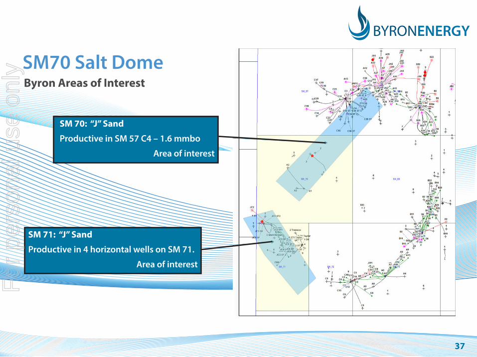
SM70 Salt DomeByron Areas of Interest
SM 70: “J” Sand
Productive in SM 57 C4 – 1.6 mmbo
Area of interest
SM 71: “J” Sand
Productive in 4 horizontal wells on SM 71.
Area of interest
For
per
sona
l use
onl
y

38
SM71 “J” Sand• 4 completions total 3.35 mmbo
• Best well: JC 3ST2 1.297 mmbo 5/1995 to 8/2001
• In May 1966, Shell drilled DST’s the Shell #2 which tested 118 bopd of 37.5 API oil from a sand we have correlated to be the J Sand.
• 3D data indicates a 150 acre updip to the highest J Sand producer (JC5 ST1) and the indicated pinch out of J Sands to the east against the dome (or rubble zone around the dome).
Shallow Prospect: 5400’ TVD
Offset fault blockShallow Prospect: 5700’ TVD
For
per
sona
l use
onl
y

39
SM71 “J” Sand
For
per
sona
l use
onl
y

40
Strategy RecapExperienced Team
• Proven track record with over 30 years’ Gulf of Mexico experience for each staff member
Gulf of Mexico Specialists
• Byron has the staff, contacts and experience to successfully permit and operate in the Gulf of Mexico
• Byron has used this experience to acquire a significant and targeted acreage position
Geophysical Expertise and Focus
• With the use of Reverse Time Migration to help resolve structural issues and Full Waveform Inversion to aid with stratigraphic resolution, Byron has identified numerous prospects in the GOM
• This acreage position was possible by adopting this strategy at least two years ahead of most of the competition in the Gulf
For
per
sona
l use
onl
y

41
Contact InformationFor more information please contact:
Maynard SmithChief ExecutiveByron Energy LimitedTel: +61 (0) 447 899 209
Prent KallenbergerChief Operating OfficerByron Energy LimitedTel: +1 337 769 0548
For
per
sona
l use
onl
y
4242
DisclaimerThis presentation is provided to you by Byron Energy Limited ABN 88 113 436 141 (“Byron”). By accepting and retaining this Corporate Presentation you acknowledge your agreement with the following terms. If you do not agree you should return it to Byron or destroy it after notifying Byron (if it cannot be returned).
Do not rely on this information This information is based on information supplied by Byron from sources believed in good faith to be reliable at the date of the presentation. Do not rely on this information to make an investment decision. This information does not constitute an invitation to apply for an offer of securities and does not contain any application form for securities. This information does not constitute an advertisement for an offer or proposed offer of securities. It is not intended to induce any person to engage in, or refrain from engaging in, any transaction.
No liabilityNo representation or warranty is made as to the fairness, accuracy or completeness of this information, or any opinions and conclusions this presentation contains or any other information which Byron otherwise provides to you. Except to the extent required by law and the Listing Rules of ASX Limited, Byron, its related bodies corporate and their respective officers, employees and advisers (together called ‘Affiliates’) do not undertake to advise any person of any new, additional or updating information coming to Byron’s or the Affiliates’ attention after the date of this presentation relating to the financial condition, status or affairs of Byron or its related bodies corporate. To the maximum extent permitted by law, Byron and its Affiliates are not liable for any direct, indirect or consequential loss or damage suffered by any person as a result of relying on this information or otherwise in connection with it.
Forward looking statementsIn particular, no representation or warranty is given as to the accuracy, completeness, likelihood of achievement or reasonableness of any forecasts, projections or forward looking statements contained in this presentation. Forecasts, projections and forward-looking statements are by their nature subject to significant uncertainties and contingencies. You should make your own independent assessment of this presentation and seek your own independent professional advice in relation to the information and any action taken on the basis of that information.
Technical InformationTechnical information contained in this presentation in relation to Byron’s projects has been reviewed by Mr Prent Kallenberger, an Executive Director and Chief Operating Officer of Byron. Mr Kallenberger holds a Bachelor of Science degree in Geology and Master of Science degree in Geophysics, and has more than 30 years experience in the practice of petroleum geosciences. Mr Kallenberger has consented to the inclusion in this presentation of the information in the form and context in which it appears.
For
per
sona
l use
onl
y