
For Periodnil Endino 1 Alllgust 1972 NATIONAL · James L. Clapp, UN 040 ... Marins Studies Center -...
12
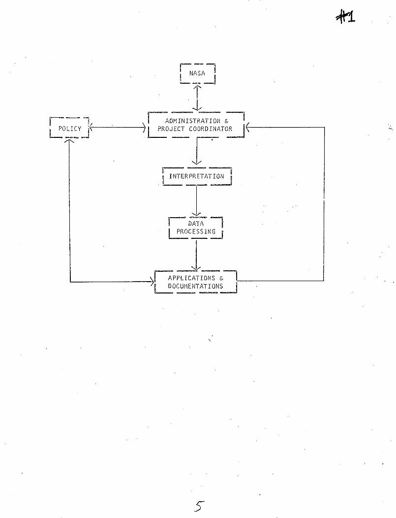
i ~,d~__ b n 0m e s H UO H 0- H O rl i* *.1 U. : . H Q (.. 0 54 0 I 3 1 ' U) G n0 l r-- i .U) 0, r- P u,H w L..- H - I c -L u) v ?' ,~,' .- : l i) -3 ,2 bo C CN Q cc" = 2! 2 XC; TYPE 1 PROGRESS REPORT For Periodnil Endino 1 Alllgust 1972 Reproduced by NATIONAL TECHNICAL INFORMATION SERVICE US Department of Commerce A. Title of Investigation: Evaluation of the Application of ERTS-A Data to the Regional Land Use Planning Process, Proposal #058 B. GSFC Identification Number of Principal Investigator' James L. Clapp, UN 040 C. Statement of Any Problems Impeding Progress of Investigation: 1-Awaiting the arrival of RB-57 imagery (Mission 205 - ERTS 058 Project - Green Bay-Milwaukee-Madison) flown on 4 June 1972 as part of this ERTS contract. 2.Awaiting the arrival of ERTS imagery. D. 3. The contract makes reference (p.8) to "exhibit C" to be used by the investigators in preparing information for the NDPF System. We are unable to find any "exhibit C" and request that copies be sent to us for Reproduced by later progress reports. NATIONAL TECHNICAL INFORMATION SERVICE US Department of Commerce Springfield, VA. 22151 Discussion of Accomplishments DuringRep-ortfnffg-r-bod and Those Planned for Next Reporting Period: (1) Period Ending 1 August 1972: Through a series of participant seminars, an organi- zational structure was developed for this project. This organizational chart (see Enclosure #1) delineates the presently perceived major responsibilities of: Admin- istration & Project Coordination; Interpretation; Data Processing; Applications & Documentation; and Policy I IN, A https://ntrs.nasa.gov/search.jsp?R=19720023677 2019-02-02T14:07:26+00:00Z
Transcript of For Periodnil Endino 1 Alllgust 1972 NATIONAL · James L. Clapp, UN 040 ... Marins Studies Center -...

i ~,d~__
b n0m e s
H UO
H 0-
H O rl
i* *.1 U. :
. H Q (..
0 54 0 I3 1'U) G
n0 l r--i .U) 0, r-
P u,H w
L..- H -
I c -L u) v
?' ,~,' .- :
l i) -3
,2 bo C
CN Q
cc" = 2!
2 XC;
TYPE 1 PROGRESS REPORT
For Periodnil Endino 1 Alllgust 1972Reproduced by
NATIONAL TECHNICALINFORMATION SERVICE
US Department of Commerce
A. Title of Investigation:
Evaluation of the Application of ERTS-A Data to the
Regional Land Use Planning Process, Proposal #058
B. GSFC Identification Number of Principal Investigator'
James L. Clapp, UN 040
C. Statement of Any Problems Impeding Progress of Investigation:
1-Awaiting the arrival of RB-57 imagery (Mission 205 -
ERTS 058 Project - Green Bay-Milwaukee-Madison) flown
on 4 June 1972 as part of this ERTS contract.
2.Awaiting the arrival of ERTS imagery.
D.
3. The contract makes reference (p.8) to "exhibit C" to
be used by the investigators in preparing information
for the NDPF System. We are unable to find any
"exhibit C" and request that copies be sent to us for
Reproduced bylater progress reports. NATIONAL TECHNICALINFORMATION SERVICE
US Department of CommerceSpringfield, VA. 22151
Discussion of Accomplishments DuringRep-ortfnffg-r-bod
and Those Planned for Next Reporting Period:
(1) Period Ending 1 August 1972:
Through a series of participant seminars, an organi-
zational structure was developed for this project. This
organizational chart (see Enclosure #1) delineates the
presently perceived major responsibilities of: Admin-
istration & Project Coordination; Interpretation; Data
Processing; Applications & Documentation; and Policy
IIN,A
https://ntrs.nasa.gov/search.jsp?R=19720023677 2019-02-02T14:07:26+00:00Z

Type 1 Progress ReportPage 2
Formulation. Individuals that are assigned to these
responsibilities are identified in Enclosure 12.
Enclosure #12 also documents those individuals on
thec Steering Comittecce of the University of Wisconsin
Environmental Monitoring and Data Acquisition Group,
which helps direct operations.
Also shown is a preliminary "advisory council"
listing which we are forming. Since only a few
individuals have been personally contacted to date,
this list primarily indicates organ:izations which
will be represented. The members of this council
will represent a cross section of land use concerns
for the state ofWisconsin. They will provide real
inputs to a total analysis of the application of
ERTS data to the regional land use planning process.
In addition to these organizational matters, work
has progressed in developing a preparedness for the
arrival of ERTS data. This included a partial
updating of the "data banks" detailed in our original
proposal. Specifically, the soils and transportation
information has been updated. Concurrently, inter-
pretation has begun of selected information from
the RB-57 mission of August/October 1971 (Mission 176 -
Green Bay-Milwaukee) for the eventual purpose of
correlation with the ERTS interpretations. In keeping
up with this preparedness, Monday meetings have been
scheduled with the Principal Investigator and Co-
2.

Type 1 Progress ReportPage 3
Investigators, and Thursday meetings with all staff
on the project, including Research Assistants and
pa rt-time help.
(2) Proposed for Period Ending 1 October 1972:
During this period the final members of the advisory
council are to be selected and initial meetings developed
to document concerns of different land use interests.
A certain amount of time is to be spent in increasing
our preparedness during the next weeks. This includes
final development of interpretation and extraction
techniques for the imagery and preparing USGS maps for
comparison. We also intend to develop programs during
this time whose function is a statistical comparison
between extracted data from ERTS and the data presently
stored in the existing data banks.
During this period the interpretation, extraction
and data storage of ERTS-A data will be initiated.
We intend to contact NASA-Houston to reconfirm the
scheduled RB-57 flight for October 1972 as part of
this contract.
Much of this initial research will be developed into
a paper which has been accepted for presentation and
publication at the Eighth International Symposium on
Remote Sensing at Ann Arbor, Michigan (2-8 October
1972). A copy of the pre-print summary (Enclosure
#3) is included with this report. Mr. Richard
Stonesifer, Technical Officer, and Mr. R. D. Phillips,
3

Type 1 Progress ReportPage 4
Contracting Officer, have already been contacted
about this in a previous letter and notified of our
desire to make this presentation and also to meet
the requirements of Article IX (Data Use and Release
Restrictions) of our contract.
E. Discussion of Significant Results:
None at this time.
F. Listing of Published/Proposed Articles:
Clapp, J.L., R. W. Kiefer, M.M. McCarthy, and B.J. Niemann,
1972. Interdisciplinary Research on the Application
of ERTS-A Data to the Regional Land Use Planning
Process. (Accepted for publication in the Proceedings
of the Eighth International Symposium on Remote Sensing
of the Environment, University of Michigan, Ann Arbor.)
F 7 -POLIlY
fNm
NASA
7AD-MINISTRATION a_PROJECT COORDINATOR _
IjNTERPRETATION
fl DATAPROCESSINGJ
[7 APPLICATIONS Li DOCUMENTATIONS L! . _
5

ADVISORYCOUNCIL
MAJOR-/CO- < ) PROJECTINVESTIGATOR __ L COORDINATOR
INTERPRETATIONCOORDINATOR
REGION REGION.ONE TWO
DATA REQUESTS
DATA PROCESS,COORDINATOR.
DATASTORAGE
I
APPLICATIONS &DOCUMENT COORDINATOR
_ lkAPPLICATIONS TOREGo PLANNING
_2

ERTS
ENVIRONmENTAL MONITORING AND DATA ACQUISITION GROUP (EMDAG)
INSTITUTE FOR ENVIRONMENTAL STUDIES (IES), and
ENVIRONMENTAL AWARENESS CENTER (EAC)
UNIVERSITY OF WISCONSIN-MADISON
PERSONNEL:
Principal Investigator:
J.L. Clapp - Professor, Civil and Environmental Engineering, and
Director, Environmental Monitoring and Data Acquisition
Group
Co-Investigators/Coordinators:
R.W. Kiefer - Interpretation Coordinator; Professor, Civil and
Environmental Engineering
M.M. McCarthy - Project Coordinator; Project Associate, Environmental
Monitoring and Data Acquisition Croup
B.J. Niemann, Jr. - Data Processing and Documentation Coordinator;
Associate Professor, and Chairman, Department of
Landscape Architecture/Environmental Awareness Center
Co-Investigators:
T. Green III - Associate Professor, Civil and Environmental Engineering,
and Department of Meteorology
M. Ostrom - Director, Wisconsin Geological and Natural History Survey
Advisory Council:
State Planning
Regional Planning
County Planning
State Department of Natural Resources
State Transportation Planning
Utilities Planning
University Extension
Geology and Hydrology
Agriculture
Forestry (Public & Private Sectors)
Recreation
Conservation and Preservation
7

Steering Committee/EbMAG:
Representatives of:
Department of Natural Resources - C.D. Besadny
Environmental Awareness Center - P.H. Lewis, Jr.
Institute for Environmental Studies - J.E. Ross
International Biological Program - O. Loucks
Marins Studies Center - R.A. Ragotzkie
Space Science and Engineering Center - T.Haig
Wisconsin Geological and Natural History Survey - M. Ostrom

INTERDISCIPLINARY RESEARCH ON THE
EVALUATION OF ERTS-A DATA TO THE
REGIONAL LAND USE PLANNING PROCESS
James L. Clapp*, Ralph W. Kiefer*,
Michael M. McCarthy**, and Bernard J. Niemann, Jr.**
Environmental Awareness Center
and
Environmental Monitoring and Data Acquisition Group
Institute for Environmental Studies
University of Wisconsin
Madison, Wisconsin
SUMMARY
This paper is concerned with the application of ERTS-A satellite data
to the regional land use planning process. The fundamental problem is to
determine which significant natural and cultural data can be identified and
evaluated using ERTS-A data. In the identification and evaluation process
the focus is placed upon: 1) scale effects, 2) spectral effects, 3) temporal
effects, and 4) pattern effects, and how each contributes to the reliability
of the acquired data. Efforts are made to determine the efficiency of ERTS-A
acquisition in comparison with resources inventories conducted by conventional
methods. Objectives of the research are:
1). Compare ERTS-A imagery to specific natural and cultural data at
varying scales and over time.
2) Determine and document usefulness of ERTS-A data for environ-
mentally based regional land use planning in Wisconsin.
3) Assist various state and university groups in obtaining inter-
agency and interdisciplinary involvement in data analysis and
* and, Department of Civil and Environmental Engineering, The Universityof Wisconsin, Madison,Wisconsin
** and, Department of Landscape Architecture, The University of Wisconsin,Madison, Wisconsin

2
interpretation of ERTS-A data for application to current land use
allocation problems.
The interdisciplinary nature of this study was enhanced by the formation
of a policy group. This group, which functions as an advisory committee,
represents the various land use interests in the state of Wisconsin.
Specifically, representation exists for: county/urban planning, regional
planning, state planning, private recreational development, government
recreational and conservation development, private conservation leagues,
agricultural uses, forestry uses, geologic uses, utility systems, and
transportation systems.
The investigation and documentation of the application of ERTS-A
imagery to the regional planning process consists of utilizing three
representative geographical regions within the state of Wisconsin. The
three locations represent: 1) a variety of natural and cultural resource
data, 2) different regional planning problems facing Wisconsin, and 3)
varying scales of data.
A critical reason for selecting the geographical regions is the manner
in which the data are stored. Because of the need to describe and depict
regional resource complexity in an interrelatable state, the data within
two of the geographical units have been inventoried and stored in a two-
dimensional computer-based map form. Computer oriented processes (entitled
REMAP I, REMAP II, and EDAP) were developed to provide-for the economical
storage, analysis and spatial display of natural and cultural data for regional
planning purposes. The third geographical region was selected to provide
area context for the entire Wisconsin region and as a base for later studies.
Geographical Region One - Southcentral and Southwestern Wisconsin.
This region includes parts of Columbia, Dane, Iowa and Rock
Counties. Two watershed studies were funded by NASA to investigate
applications of remote sensing to watershed management. Remote
I0
sensing techniques were extensively used to obtain information for
these watersheds. These two studies collectively contain over 70
different variables using spatial computer data bases. A third
data bank was developed for parts of three of the counties to
determine optimum electric energy transmission systems location.
This spatial data base (EDAP) contains over 196 natural and
cultural variables. The four-county data base consists of infor-
mation necessary for urban aspects of regional planning and a
variety of land uses representing a continuum of impacts.
Geographical Region Two - Southeast to Northeast Wisconsin.
The data bank for this region was developed to assist the Wisconsin
Division of Highways locate Interstate 57 between Green Bay and
Milwaukee. The data base has been completed and highway corridors
selected and recommended. The area represents a variety of urban,
agricultural, water and recreational resources within a major
population growth region in Wisconsin. The data base for this
region has 330 manipulatable variables for the REMAP II program
and 132 variables for the REMAP I system. The study spatially
relates data requiring computer storage for 1,228,128 separate
bits of data.
Geographical Region Three - State of Wisconsin and Contiguous Lakes.
The Wisconsin Geological and Natural History Survey has collected
geological and soils data for the entire state. The University
of Wisconsin Marine Studies Center has investigated the current
patterns in Lake Michigan and Lake Superior, as well as near-shore
circulation characteristics.
This paper describes attempts to investigate the correlations between
the stored data bank information and the interpreted ERTS-A data. With
regard to the natural and cultural data items under investigation, the
II ·

4
study is concerned with: 1) which data are discernible from ERTS-A imagery;
2) to what quantitative extent can these data be inventoried from ERTS-A
imagery; and 3) at what times of year can the data be most efficiently
interpreted and inventoried.
Although the degree to which ERTS imagery can satisfy regional land
use planning data needs is not known, it appears to offer means by which
the data acquisition process can be immeasurably improved. This paper
documents the initial experiences of an interdisciplinary group using
ERTS-A imagery as a base for environmental monitoring and the resolution
of regional land allocation problems.
* ' ~~~~12