For Peer Review - Imperial College London · For Peer Review Impacts of land use on the...
55
For Peer Review Impacts of land use on the hydrological response of tropical Andean catchments Journal: Hydrological Processes Manuscript ID HYP-15-0972.R2 Wiley - Manuscript type: South American Hydrology Date Submitted by the Author: n/a Complete List of Authors: Ochoa-Tocachi, Boris; Imperial College London, Department of Civil and Environmental Engineering & Grantham Institute - Climate Change and the Environment; Consorcio para el Desarrollo Sostenible de la Ecorregión Andina (CONDESAN), Área de Cuencas Andinas; Regional Initiative for Hydrological Monitoring of Andean Ecosystems (iMHEA), Andes, South America Buytaert, Wouter; Imperial College London, Department of Civil and Environmental Engineering & Grantham Institute - Climate Change and the Environment; Regional Initiative for Hydrological Monitoring of Andean Ecosystems (iMHEA), Andes, South America De Bièvre, Bert; Consorcio para el Desarrollo Sostenible de la Ecorregión Andina (CONDESAN), Área de Cuencas Andinas; Regional Initiative for Hydrological Monitoring of Andean Ecosystems (iMHEA), Andes, South America; Fondo para la Protección del Agua (FONAG), Technical Secretary Célleri, Rolando; Universidad de Cuenca, Departamento de Recursos Hídricos y Ciencias Ambientales & Facultad de Ciencias Agropecuarias; Regional Initiative for Hydrological Monitoring of Andean Ecosystems (iMHEA), Andes, South America Crespo, Patricio; Universidad de Cuenca, Departamento de Recursos Hídricos y Ciencias Ambientales & Facultad de Ciencias Agropecuarias; Regional Initiative for Hydrological Monitoring of Andean Ecosystems (iMHEA), Andes, South America Villacís, Marcos; Escuela Politécnica Nacional, Departamento de Ingeniería Civil y Ambiental; Regional Initiative for Hydrological Monitoring of Andean Ecosystems (iMHEA), Andes, South America Llerena, Carlos; Universidad Nacional Agraria La Molina, Facultad de Ciencias Forestales; Regional Initiative for Hydrological Monitoring of Andean Ecosystems (iMHEA), Andes, South America Acosta, Luis; Consorcio para el Desarrollo Sostenible de la Ecorregión Andina (CONDESAN), Área de Cuencas Andinas; Regional Initiative for Hydrological Monitoring of Andean Ecosystems (iMHEA), Andes, South America; Superintendencia Nacional de Servicios de Saneamiento, Gerencia de Políticas y Normas Villazón, Mauricio; Universidad Mayor de San Simón, Laboratorio de Hidráulica (LHUMSS) & Facultad de Ciencias y Tecnología; Regional Initiative for Hydrological Monitoring of Andean Ecosystems (iMHEA), Andes, South America Guallpa, Mario; Empresa Pública Municipal de Telecomunicaciones, Agua Potable, Alcantarillado y Saneamiento de Cuenca (ETAPA EP), Subgerencia de Gestión Ambiental; Regional Initiative for Hydrological Monitoring of Andean Ecosystems (iMHEA), Andes, South America Gil-Ríos, Junior; Consorcio para el Desarrollo Sostenible de la Ecorregión http://mc.manuscriptcentral.com/hyp Hydrological Processes
Transcript of For Peer Review - Imperial College London · For Peer Review Impacts of land use on the...

For Peer Review
Impacts of land use on the hydrological response of tropical
Andean catchments
Journal: Hydrological Processes
Manuscript ID HYP-15-0972.R2
Wiley - Manuscript type: South American Hydrology
Date Submitted by the Author: n/a
Complete List of Authors: Ochoa-Tocachi, Boris; Imperial College London, Department of Civil and Environmental Engineering & Grantham Institute - Climate Change and the Environment; Consorcio para el Desarrollo Sostenible de la Ecorregión Andina (CONDESAN), Área de Cuencas Andinas; Regional Initiative for Hydrological Monitoring of Andean Ecosystems (iMHEA), Andes, South America Buytaert, Wouter; Imperial College London, Department of Civil and Environmental Engineering & Grantham Institute - Climate Change and the Environment; Regional Initiative for Hydrological Monitoring of Andean Ecosystems (iMHEA), Andes, South America De Bièvre, Bert; Consorcio para el Desarrollo Sostenible de la Ecorregión Andina (CONDESAN), Área de Cuencas Andinas; Regional Initiative for Hydrological Monitoring of Andean Ecosystems (iMHEA), Andes, South America; Fondo para la Protección del Agua (FONAG), Technical Secretary Célleri, Rolando; Universidad de Cuenca, Departamento de Recursos Hídricos y Ciencias Ambientales & Facultad de Ciencias Agropecuarias; Regional Initiative for Hydrological Monitoring of Andean Ecosystems (iMHEA), Andes, South America Crespo, Patricio; Universidad de Cuenca, Departamento de Recursos Hídricos y Ciencias Ambientales & Facultad de Ciencias Agropecuarias; Regional Initiative for Hydrological Monitoring of Andean Ecosystems (iMHEA), Andes, South America Villacís, Marcos; Escuela Politécnica Nacional, Departamento de Ingeniería Civil y Ambiental; Regional Initiative for Hydrological Monitoring of Andean Ecosystems (iMHEA), Andes, South America Llerena, Carlos; Universidad Nacional Agraria La Molina, Facultad de Ciencias Forestales; Regional Initiative for Hydrological Monitoring of Andean Ecosystems (iMHEA), Andes, South America Acosta, Luis; Consorcio para el Desarrollo Sostenible de la Ecorregión Andina (CONDESAN), Área de Cuencas Andinas; Regional Initiative for Hydrological Monitoring of Andean Ecosystems (iMHEA), Andes, South America; Superintendencia Nacional de Servicios de Saneamiento, Gerencia de Políticas y Normas Villazón, Mauricio; Universidad Mayor de San Simón, Laboratorio de Hidráulica (LHUMSS) & Facultad de Ciencias y Tecnología; Regional Initiative for Hydrological Monitoring of Andean Ecosystems (iMHEA), Andes, South America Guallpa, Mario; Empresa Pública Municipal de Telecomunicaciones, Agua Potable, Alcantarillado y Saneamiento de Cuenca (ETAPA EP), Subgerencia de Gestión Ambiental; Regional Initiative for Hydrological Monitoring of Andean Ecosystems (iMHEA), Andes, South America Gil-Ríos, Junior; Consorcio para el Desarrollo Sostenible de la Ecorregión
http://mc.manuscriptcentral.com/hyp
Hydrological Processes

For Peer Review
Andina (CONDESAN), Área de Cuencas Andinas; Regional Initiative for Hydrological Monitoring of Andean Ecosystems (iMHEA), Andes, South America Fuentes, Paola; Fondo para la Protección del Agua (FONAG), Technical Secretary; Regional Initiative for Hydrological Monitoring of Andean Ecosystems (iMHEA), Andes, South America Olaya, Roberto; Naturaleza y Cultura Internacional (NCI), iMHEA Piura; Regional Initiative for Hydrological Monitoring of Andean Ecosystems (iMHEA), Andes, South America Viñas, Paúl; Naturaleza y Cultura Internacional (NCI), iMHEA Piura; Regional Initiative for Hydrological Monitoring of Andean Ecosystems (iMHEA), Andes, South America Rojas, Gerver; Asociación Peruana para la Conservación de la Naturaleza (APECO), ACP Tilacancha; Regional Initiative for Hydrological Monitoring of Andean Ecosystems (iMHEA), Andes, South America Arias, Sandro; Servicio Nacional de Meteorología e Hidrología del Perú, SENAMHI Cusco; Regional Initiative for Hydrological Monitoring of Andean Ecosystems (iMHEA), Andes, South America
Keywords: hydrological response, land use, Andes, Páramo, Puna, Jalca
Page 1 of 53
http://mc.manuscriptcentral.com/hyp
Hydrological Processes
123456789101112131415161718192021222324252627282930313233343536373839404142434445464748495051525354555657585960

For Peer Review
Impacts of land use on the hydrological response of tropical Andean catchments
Authors:
Boris F. Ochoa-Tocachia,b,z, [email protected]*
Wouter Buytaerta,z, [email protected]
Bert De Bièvreb,z,1, [email protected]
Rolando Célleric,z, [email protected]
Patricio Crespoc,z, [email protected]
Marcos Villacísd,z, [email protected]
Carlos A. Llerenae,z, [email protected]
Luis Acostab,z,2, [email protected]
Mauricio Villazónf,z, [email protected]
Mario Guallpag,z, [email protected]
Junior Gil-Ríosb,z, [email protected]
Paola Fuentesh,z, [email protected]
Dimas Olayai,z, [email protected]
Paúl Viñasi,z, [email protected]
Gerver Rojasj,z, [email protected]
Sandro Ariask,z, [email protected]
Affiliations:
Page 2 of 53
http://mc.manuscriptcentral.com/hyp
Hydrological Processes
123456789101112131415161718192021222324252627282930313233343536373839404142434445464748495051525354555657585960

For Peer Review
a Imperial College London, Department of Civil and Environmental Engineering &
Grantham Institute – Climate Change and the Environment, South Kensington Campus,
London, United Kingdom SW72AZ
b Consorcio para el Desarrollo Sostenible de la Ecorregión Andina (CONDESAN), Área de
Cuencas Andinas, Lima, Peru 15024
c Universidad de Cuenca, Departamento de Recursos Hídricos y Ciencias Ambientales &
Facultad de Ciencias Agropecuarias, Av. 12 de Abril s/n, Cuenca, Ecuador 010203
d Escuela Politécnica Nacional, Departamento de Ingeniería Civil y Ambiental, Quito,
Ladrón de Guevara E11-253, Ecuador 170525
e Universidad Nacional Agraria La Molina, Facultad de Ciencias Forestales, Lima, Perú
12056
f Universidad Mayor de San Simón, Laboratorio de Hidráulica (LHUMSS) & Facultad de
Ciencias y Tecnología, Av. Petrolera Km. 4.2, Cochabamba, Bolivia 6760
g Empresa Pública Municipal de Telecomunicaciones, Agua Potable, Alcantarillado y
Saneamiento de Cuenca (ETAPA EP), Subgerencia de Gestión Ambiental, Cuenca,
Ecuador 010101
h Fondo para la Protección del Agua (FONAG), Quito, Ecuador 170137
i Naturaleza y Cultura Internacional (NCI), Piura, Peru 20009
j Asociación Peruana para la Conservación de la Naturaleza (APECO), Chachapoyas, Peru
01001
k Servicio Nacional de Meteorología e Hidrología del Perú, Cusco, Peru 08007
z Regional Initiative for Hydrological Monitoring of Andean Ecosystems (iMHEA), Andes,
South America
Page 3 of 53
http://mc.manuscriptcentral.com/hyp
Hydrological Processes
123456789101112131415161718192021222324252627282930313233343536373839404142434445464748495051525354555657585960

For Peer Review
1 Present address: Fondo para la Protección del Agua (FONAG), Technical Secretary,
Quito, EC 170137
2 Present address: Superintendencia Nacional de Servicios de Saneamiento, Gerencia de
Políticas y Normas, Lima, Peru 15073
* Corresponding Author: Boris F. Ochoa-Tocachi, Department of Civil and Environmental
Engineering & Grantham Institute – Climate Change and the Environment, Imperial
College London, Skempton Building – Room 411, South Kensington Campus, London SW7
2AZ, UK, Tel.: +44 (0) 7463263232, e-mail: [email protected].
Running head: Ochoa-Tocachi et al: Land use impacts on tropical Andean hydrology
Keywords: hydrological response, land use, LUCC, Andes, Páramo, Puna, Jalca, indices.
ABSTRACT
Changes in land use and land cover are major drivers of hydrological alteration in
the tropical Andes. However, quantifying their impacts is fraught with difficulties because
of the extreme diversity in meteorological boundary conditions, which contrasts strongly
with the lack of knowledge about local hydrological processes. Although local studies have
reduced data scarcity in certain regions, the complexity of the tropical Andes poses a big
challenge to regional hydrological prediction.
This study analyses data generated from a participatory monitoring network of 25
headwater catchments covering three of the major Andean biomes (páramo, jalca, and
Page 4 of 53
http://mc.manuscriptcentral.com/hyp
Hydrological Processes
123456789101112131415161718192021222324252627282930313233343536373839404142434445464748495051525354555657585960
For Peer Review
puna), and link their hydrological responses to main types of human interventions
(cultivation, afforestation and grazing). A paired catchment setup was implemented to
evaluate the impacts of change using a “trading space-for-time” approach. Catchments were
selected based on regional representativeness and contrasting land use types. Precipitation
and discharge have been monitored and analysed at high temporal resolution for a time
period between 1 and 5 years.
The observed catchment responses clearly reflect the extraordinarily wide spectrum
of hydrological processes of the tropical Andes. They range from perennially humid
páramos in Ecuador and northern Peru with extremely large specific discharge and
baseflows, to highly seasonal, flashy catchments in the drier punas of southern Peru and
Bolivia. The impacts of land use are similarly diverse and their magnitudes are a function
of catchment properties, original and replacement vegetation, and management type.
Cultivation and afforestation consistently affect the entire range of discharges, particularly
low flows. The impacts of grazing are more variable, but have the largest effect on the
catchment hydrological regulation. Overall, anthropogenic interventions result in increased
streamflow variability and significant reductions in catchment regulation capacity and
water yield, irrespective of the hydrological properties of the original biome.
1. INTRODUCTION
1.1. Andean ecosystem degradation and water resources
The tropical Andes deliver a large portfolio of ecosystem services, but remarkably
an abundant and sustained supply of clean fresh water (Buytaert et al., 2006a; Roa-García
et al., 2011). Groundwater in these regions is difficult to extract (Buytaert et al., 2007),
Page 5 of 53
http://mc.manuscriptcentral.com/hyp
Hydrological Processes
123456789101112131415161718192021222324252627282930313233343536373839404142434445464748495051525354555657585960

For Peer Review
which results in a predominant use of surface water sources that are particularly vulnerable
to environmental changes (Bradley et al., 2006), hydrological extremes (Bradshaw et al.,
2007), increasing water demand (Buytaert and De Bièvre, 2012), and a very dynamic land
use as a result of rural development (Buytaert et al., 2006a).
Anthropogenic disturbance in the tropical Andes started as early as 7000 years ago,
but it has intensified after the colonial period in the 16th century and particularly extended
since the early 20th century (Bruhns, 1994, White and Maldonado, 1991, as cited by Molina
et al., 2015; Etter and van Wyngaarden, 2000, as cited by Roa-García et al., 2011;
Sarmiento 2000; Harden, 2006). Changes in land use are largely driven by population
growth, including livestock grazing in extensive areas (Molina et al., 2007), cultivation of
mostly cereals and tubers (Sarmiento, 2000), and afforestation with exotic species
introduced as a way to improve their economic viability (Farley et al., 2004). An example
of the latter are unsuccessful efforts of local authorities to replicate a positive experience
from Cajamarca, Peru, where degraded lands were restored mostly using Pinus patula
(~60%), Pinus radiata and Eucalyptus globulus. However, the increase in subsurface flow
associated with forests (Tobón, 2009) contrasts with negative impacts on local biodiversity
(Hofstede et al., 2002) and total water yield (Buytaert et al., 2007).
The severe ecosystem degradation contrasts strongly with the lack of knowledge
about the strong spatiotemporal gradients of local climate and hydrological processes that
govern them (Célleri and Feyen, 2009). Much of the global surface is ungauged or poorly
gauged (Fekete and Vörösmarty, 2007), but tropical regions in particular are characterised
by data scarcity (Wohl et al., 2012). This is exacerbated by the tendency of national
hydrometeorological networks to cover inadequately remote headwater areas (Célleri et al.,
Page 6 of 53
http://mc.manuscriptcentral.com/hyp
Hydrological Processes
123456789101112131415161718192021222324252627282930313233343536373839404142434445464748495051525354555657585960

For Peer Review
2010). As a result, the hydrological impacts of land use and that of many other anthropic
activities in the region, such as watershed management, conservation and investment (e.g.
Asquith and Wunder, 2008; Tallis and Polasky, 2009; Garzon, 2010) have not been
evaluated properly.
Over the last decades, hydrological research in the tropical Andes has increased
(e.g. as reviewed by Célleri and Feyen, 2009; Célleri, 2010). However, most studies have
focused on the wet páramo ecosystems (Buytaert et al., 2006a; Crespo et al., 2010; Molina
et al., 2015) and high Andean forests (Bruijnzeel, 2004; Tobón, 2009; Crespo et al., 2012),
while other biomes such as dry páramo, jalca, and puna are underrepresented. The extreme
variety of meteorological boundary conditions, vegetation types, soils, geology and
topography leads to similarly diverse and non-stationary hydrological processes at multiple
scales (e.g. Vuille et al., 2000; Bendix et al., 2006; Mora and Willems, 2012), which
complicates further hydrological predictions in unmonitored regions. It is therefore
paramount to increase the number, representativeness, and quality of monitoring sites to
cover the broad diversity of Andean ecosystems (Célleri et al., 2010).
1.2. Hydrological processes in Andean catchments
The tropical Andes can be divided broadly in five major landscape units (Cuesta et
al., 2009): páramo, puna, Andean forests, inter-Andean valleys, and mountain deserts or
salt flats. They are distinguished by thermal limits and latitude (Josse et al. 2009, Figure 1).
The páramo, jalca and puna are mountainous highlands that span above the forest line
(3000 to 3500 m altitude) and the permanent snow line (4500 to 5000 m altitude) (Buytaert
et al., 2006a; Sánchez-Vega and Dillon, 2006; Célleri et al., 2010). The páramo biome
Page 7 of 53
http://mc.manuscriptcentral.com/hyp
Hydrological Processes
123456789101112131415161718192021222324252627282930313233343536373839404142434445464748495051525354555657585960
For Peer Review
covers the upper Andean region of western Venezuela, Colombia, Ecuador, and northern
Peru, where the transition to the puna originates the jalca formations. Humid puna extends
from eastern Peru until the north-eastern Bolivian Cordillera, whereas dry puna is located
from western Peru until the southwest of Bolivia and northern Argentina and Chile.
The latitudinal variability of physical characteristics, such as soil conditions, is less
influential compared to the effect of the Pacific Ocean and the Amazon plains that induce
more conspicuous differences in hydrological responses for respectively the Western and
Eastern Cordilleras (Josse et al., 2009). Additionally, Andean forests and, occasionally,
glaciers are located respectively below and above gradual limiting lines with the highlands,
and are therefore associated with them especially on the common fringes (Cuesta et al.,
2009; Soruco et al., 2015).
No existing scientific studies were found on the hydrology of punas and jalcas, thus
most of the currently available hydrological knowledge relates to wet páramos. These
highlands feature typical high tropical mountain climate patterns (Buytaert et al., 2006a;
Viviroli et al., 2007). Regions located closer to the equator have low seasonal variability,
with solar radiation and mean air temperature almost constant throughout the year. But
diurnal temperature cycles are highly marked, and can range between 0º and 20°C
(Buytaert et al., 2006a, 2007; Córdova et al., 2015). Luteyn (1992), Buytaert et al. (2006a)
and Molina et al. (2015) have reported annual precipitation amounts between 500 and 3000
mm year-1, with an exceptionally high spatiotemporal variability (Buytaert et al., 2006b;
Célleri et al., 2007). In contrast, characterizing reference evapotranspiration has been
limited by the scarce availability of meteorological data. Although some values have been
Page 8 of 53
http://mc.manuscriptcentral.com/hyp
Hydrological Processes
123456789101112131415161718192021222324252627282930313233343536373839404142434445464748495051525354555657585960
For Peer Review
reported (e.g. 646 mm year-1, Buytaert et al., 2007; 723 mm year-1, Córdova et al., 2015),
errors are thought to be as high as 30% with limited data (Córdova et al., 2015).
The hydrological response of reported Andean catchments is strongly related to
their soil conditions. Buytaert et al. (2005) showed that the hydraulic conductivity of wet
páramo soils prevented soil moisture to drop below 60 vol%, reducing the probability of
water stress occurrence. Previously, Buytaert et al. (2004) analysed the recession curves of
a natural catchment finding three main responses attributed to overland flow, interflow, and
baseflow on the basis of their residence time. The study also found that interflow was less
important, and later Buytaert et al. (2007) and Crespo et al. (2010) pointed the virtual
absence of infiltration excess overland flow. A particular characteristic of most of the
studied high Andean catchments is the presence of underlying impermeable bedrock that
minimises deep infiltration and groundwater storage (Buytaert et al., 2007), but some
regions also present deep permeable soils and sustain important aquifers (Buytaert et al.,
2006a; Favier et al., 2008). Runoff ratios between 0.50 to 0.70 have been reported in
natural wet páramos (Buytaert et al., 2007), while more recently Mosquera et al. (2015)
have found that water yield increases with the extent of wetlands, likely because of
saturation excess flow occurrence.
Additionally, Buytaert and Beven (2011) also highlight the importance of threshold-
triggered and non-stationary hydrological processes, such as disconnected water storages
found within the catchment microtopography, or changing evapotranspiration, infiltration,
and routing produced by growing vegetation. Lastly, in areas covered by fog, horizontal
precipitation and cloud water interception may account for 10% to 35% of total
Page 9 of 53
http://mc.manuscriptcentral.com/hyp
Hydrological Processes
123456789101112131415161718192021222324252627282930313233343536373839404142434445464748495051525354555657585960
For Peer Review
precipitation, particularly in forested catchments (Bruijnzeel, 2004; Tobón, 2009; Pryet et
al., 2012). However, no studies were found relating to the studied biomes.
To address this regional knowledge gap, this paper presents an analysis of data
generated from a network of paired catchments in the tropical Andes to regionalise human
impacts on their hydrological response and water yield. This research builds upon several
years of extensive study by the Regional Initiative for Hydrological Monitoring of Andean
Ecosystems (iMHEA, Célleri et al., 2010). Using 25 catchments distributed from Ecuador
to Bolivia, the main objective of this paper is to include previously underrepresented
ecosystems (jalca and puna) in a region-wide analysis of the impacts of land use across
tropical Andean biomes. We make use of hydrological indices to test the generalisation of
results in areas generally facing data-scarcity yet intense use. These results may be used to
improve water resources management and the effectiveness of watershed interventions, as
well as to support emergent research in the Andean region.
2. METHODOLOGY
2.1. Regional setting
Emerging from a local awareness about the need for better information on
watershed interventions in the Andes, a partnership of academic and non-governmental
institutions pioneered in participatory hydrological monitoring (Célleri et al., 2010;
Buytaert et al., 2014). The collaborative nature of iMHEA allows for (i) standardising
monitoring practices by a unique protocol; (ii) ensuring quality and support from research
groups to local stakeholders through the entire monitoring process; (iii) local responsibility
for equipment and civil structure safety and maintenance, data downloading, and project
Page 10 of 53
http://mc.manuscriptcentral.com/hyp
Hydrological Processes
123456789101112131415161718192021222324252627282930313233343536373839404142434445464748495051525354555657585960

For Peer Review
co-funding by development institutions; and, (iv) promoting linkages with
hydrometeorological and environmental authorities, policy makers, and society involved in
water governance in the region.
The local partners of iMHEA have been monitoring a set of 25 catchments
distributed along the tropical Andes (Figure 1, Table I). The catchments, sized between 0.5
and 7.8 km2, are located between 0º and 17º South and cover an elevation range from 2682
to 4840 m altitude. Sites are rural with no urbanisation and not affected by water
abstractions or stream alterations. Most of the catchments have a natural land cover of
tussock and other grasses, interspersed with wetlands, shrubs, and patches of native forest.
Shapes are typically oval tending to circular or stretched, and slopes are steep and uneven.
The main land uses are for conservation, grazing, afforestation and cultivation, which are
those addressed in this study.
2.2. Monitoring setup to assess land use change impacts
Quantifying the impacts of land use and cover change (LUCC) on the water cycle is
complicated by the difficulty of distinguishing the effects of such changes from those that
are due natural climatic variability or other confounding factors (Ashagrie et al., 2006;
Bulygina et al., 2009). Assessing these impacts relies on analysing signals of change over
time or contrasting differences in hydrological responses between two or more catchments
(McIntyre et al., 2014).
Hydrologically, each method has different disadvantages. In long-term analysis,
even though the same catchment is monitored before and after the change, natural climatic
variability may influence differently during the two considered periods (Lørup et al., 1998).
Page 11 of 53
http://mc.manuscriptcentral.com/hyp
Hydrological Processes
123456789101112131415161718192021222324252627282930313233343536373839404142434445464748495051525354555657585960
For Peer Review
This is addressed in the second approach by monitoring paired catchments under the same
climatic conditions and different watershed interventions. However, this may complicate
the attribution of observed differences to the uniqueness of catchments, as land use is not
the only factor that affects their hydrological response (Bosch and Hewlett, 1982; Thomas
and Megahan, 1998; Beven, 2000; McIntyre et al., 2014). Nevertheless, on balance, the
paired catchment approach delivers more rapid answers by “trading space for time” (e.g.
Buytaert and Beven, 2009, 2011; Singh et al., 2011, Sivapalan et al., 2011), allowing for
faster input in often urgent policy decisions. Additionally, the approach can be made more
robust by considering a large number of catchments covering a wide range of ecosystems,
land uses, and physical and climatic characteristics.
In our paired catchments, streamflow has been measured using a compound sharp-
crested weir (a V-shaped section for low flows and a triangular-rectangular section for high
flows) equipped with pressure transducers at the outlet of each catchment. Water level
recordings are taken at a regular interval of maximum 15-min and typically 5-min.
Precipitation has been measured with a minimum of 2 tipping-bucket rain gauges at an
installed height of 1.50 m (resolutions of 0.254, 0.2, or 0.1 mm) distributed in the
catchment areas to account for small scale spatial variability (Buytaert et al., 2006b; Célleri
et al., 2007). Table II shows the different monitoring periods of the catchments.
2.3. Data analysis
A preliminary survey of catchment physical features was done before selection and
to consider their influence on the hydrological response. Contour lines at 40 m vertical
resolution were available for the characterisation of elevations and slopes. Because only a
Page 12 of 53
http://mc.manuscriptcentral.com/hyp
Hydrological Processes
123456789101112131415161718192021222324252627282930313233343536373839404142434445464748495051525354555657585960
For Peer Review
limited number of catchments is equipped with a meteorological station, reference
evapotranspiration was estimated using Worldclim temperature data (Hijmans et al., 2005)
and the Hargreaves formula (Hargreaves and Samani, 1985; Allen et al., 1998).
The tipping bucket rainfall data were processed using a composite cubic spline
interpolation on the cumulative rainfall curve (Sadler and Busscher, 1989; Ciach, 2003;
Wang et al., 2008; Padrón et al., 2015) and aggregated at intervals matching discharge time
steps (i.e. daily, monthly, and annual scales for hydrological indices and sub-daily scales
for rainfall intensities). A 5-min scale moving window was used to calculate rainfall
intensity curves for durations between 5 min and 2 days. The seasonality index (Walsh and
Lawler, 1981) was calculated and normalised between 0 (non-seasonal) and 1 (extremely
seasonal). Correlations between the multiple local rain gauges were used to detect and
correct errors, to fill data gaps, and to obtain reliable averaged values.
The Kindsvater-Shen relation (USDI, 2001) was used to transform water level to
streamflow, complemented with manual stage-discharge measurements. Flow Duration
Curves (FDC) and corresponding percentiles were calculated based on the daily flows using
the plotting position of Gringorten (1963). The slope between 33% and 66% of the FDC is
commonly used as an indicator of hydrological regulation (Olden and Poff, 2003). A steep
slope is associated with high flashiness response to input precipitation, whereas a flatter
curve represents buffered behaviour and larger storage capacity (Buytaert et al., 2007;
Yadav et al., 2007). Although flow percentiles are associated to their probability of
occurrence, information about when or for how long such flows happen is absent.
Therefore, the average duration of hydrographs above or below a threshold help
complement this information.
Page 13 of 53
http://mc.manuscriptcentral.com/hyp
Hydrological Processes
123456789101112131415161718192021222324252627282930313233343536373839404142434445464748495051525354555657585960
For Peer Review
In order to assess the impacts of cultivation, afforestation, and grazing on the
hydrological response and water yield, a set of indices is compared between reference and
altered catchments and contrasted across biomes (Table III). Precipitation is summarized in
the seasonality index (SINDX), annual ratio of days with zero precipitation (DAYP0) and
daily rainfall variability (PVAR). For discharge we use the runoff ratio (RR), daily flow
variability (QVAR), slope of the flow duration curve (R2FDC), the hydrological regulation
index (IRH), average low flow duration below the 25th flow percentile (DLQ75), and
average high flow duration above the 75th flow percentile (DHQ25). To assess differences
in streamflow flashiness and response to precipitation events, we also compare high-
resolution sections of the monitored precipitation and discharge time series. Hydrological
indices were calculated using the entire available dataset for each catchment, while a 30-
day scale time window is used for visualisation purposes highlighting representative effects
of land use change on catchment regulation that are consistently observed in the complete
analysis periods.
3. RESULTS
3.1. The natural hydrological regime
Table II, and Figures 1 and 2 show results of the monitoring of precipitation and
streamflow for the three major biomes in the highlands of Ecuador, Peru, and Bolivia:
páramo, jalca, and puna. The studied catchments represent an extraordinary wide spectrum
of characteristics and clearly reflect the dominant regional regimes of the tropical Andes.
In northern Ecuador, stations located on the eastern side of the Andes (JTU) have a
stronger influence from the Amazon regime, resulting in a more pronounced dry season
Page 14 of 53
http://mc.manuscriptcentral.com/hyp
Hydrological Processes
123456789101112131415161718192021222324252627282930313233343536373839404142434445464748495051525354555657585960

For Peer Review
during the boreal winter (DJF). In contrast, dry months in the western slopes at similar
latitude (LLO) occur during the summer (JJA). Despite their low seasonality
(SINDX<0.32), DAYP0 was as high as 0.52 in LLO, and daily precipitation was more
variable than in other páramo catchments (PVAR>1.70). However, daily discharges were
considerably more stable (QVAR<1.44).
The catchments located in the páramo of southern Ecuador and northern Peru
exhibit a perennially wet, bimodal regime similar to that described by Bendix (2000) and
Célleri et al. (2007). In the case of the páramo in Piura, this is characterised by a Pacific
climate influence increased further by Amazonian air masses that penetrate the Andes
through the Huancabamba depression (Figure 2). The seasonality is low (SINDX<0.30,
DAYP0<0.30), which means that precipitation is well distributed throughout the year with
high intensity events occurring approximately every three months (January, March, June,
and October). This results in a low variability of streamflow (PVAR<1.60, QVAR<1.10)
and high specific discharge.
In contrast, catchments located further south in the jalca and puna biomes only
receive moisture from the Amazon basin because of the arid climate system of the Peruvian
Pacific coast (Figure 2). These catchments tend to have monomodal precipitation regimes
with a clear humidity gradient decreasing from east to west. Seasonality and rainfall
intensities are much lower in the jalca of Chachapoyas (SINDX<0.20, DAYP0<0.32),
which results in small, sustained streamflows with low variability during the entire year
(PVAR<1.61, QVAR<1.10).
The puna catchments of southern Peru and Bolivia have the most pronounced
seasonal regime (SINDX>0.30, DAYP0>0.60), with high intensities during the boreal
Page 15 of 53
http://mc.manuscriptcentral.com/hyp
Hydrological Processes
123456789101112131415161718192021222324252627282930313233343536373839404142434445464748495051525354555657585960

For Peer Review
winter. As shown in Figure 2 for the puna in Tiquipaya, this produces highly seasonal and
variable discharge volumes falling nearly to zero during the driest months (PVAR>2.36,
QVAR>2.10). The humid puna of Huaraz in central Peru still shares precipitation
characteristics similar to those of the páramo further north (i.e. large annual rainfall,
DAYP0<0.26, PVAR<1.61), yet seasonality is larger and precipitation during dry months
(JJA) may be as low as 3 mm month-1 (Figure 1).
Natural Andean ecosystems are associated with FDC profiles with a low slope
indicating good hydrological regulation capacity (R2FDC~0, IRH>0.50), often diminished
because of LUCC. As can be seen in Figure 2, the jalca exhibited the most horizontal
profile, followed by the páramo, while the curve in the puna revealed a larger difference
between high and low flows. Additionally, average runoff ratios (RR) of natural catchments
are between 0.37 and 0.72 in the páramo, 0.60 in jalca, and between 0.30 and 0.70 in the
puna.
3.2. The impacts of land use change
3.2.1. Cultivation
Figure 3 shows that cultivated catchments respond to rainfall events with higher and
more rapid peak flows, while the recession curves drop faster sustaining lower baseflows.
This indicates a loss of hydrological regulation capacity, which is also reflected in a steeper
FDC. While high flows remain very similar among pairs, mean daily flows are
approximately half those of natural catchments, and low flows are lower with an average
ratio of 5. QVAR is high in both the natural and cultivated puna, yet larger when the
páramo is intervened. Additionally, DLQ75 and DHQ25 are about 60% lower in the
Page 16 of 53
http://mc.manuscriptcentral.com/hyp
Hydrological Processes
123456789101112131415161718192021222324252627282930313233343536373839404142434445464748495051525354555657585960
For Peer Review
cultivated catchments of both biomes, which may indicate a flashier streamflow regime
under cultivation.
The impacts of agriculture on water yield are more difficult to identify, with only a
slightly lower discharge in both biomes. After correction for rainfall volume differences,
water yield in the natural and cultivated páramo differ in 142 mm year-1 (RR: 0.75 vs 0.66),
but only 8 mm year-1 in puna (RR: 0.33 vs 0.28). However, on average, such differences
still lie within the broad range of natural catchments.
3.2.2. Afforestation
Figure 4 shows that the flow regime drastically changes under afforestation,
reducing the entire flow distribution but increasing the steepness of the FDC. High and
mean daily flows in afforested catchments are approximately 4 times lower, whilst low
flows are even 7 times lower (up to 10 times in the jalca). This results consistently in a
much lower water yield under afforestation compared to their neighbouring natural
catchments. Corrected discharges differ by 250 mm year-1 (RR: 0.43 vs 0.20) in the
páramo, in 386 mm year-1 (RR: 0.60 vs 0.19) in the jalca, and up to in 536 mm year-1 (RR:
0.58 vs 0.20) in the puna.
Additionally, although the occurrence of sustained precipitation events increases
streamflow in natural watersheds, this response is virtually absent in the afforested
catchments. At the same time, we also find that QVAR is 50% higher under afforestation
than under natural grasslands, reflecting a relatively higher variability in daily flows
overall. Furthermore, whereas DLQ75 is slightly lower in the afforested catchments,
Page 17 of 53
http://mc.manuscriptcentral.com/hyp
Hydrological Processes
123456789101112131415161718192021222324252627282930313233343536373839404142434445464748495051525354555657585960

For Peer Review
suggesting an improvement in hydrological regulation, DHQ25 is twice as high in the
afforested páramo and jalca but only half in the afforested puna.
3.2.3. Grazing
The impacts of grazing are more difficult to identify on aggregated statistics. Under
low intensity grazing in two páramo catchments with deep soils located in northwestern
Ecuador (LLO_01 and LLO_02, Figure 5), the water yield is 115 mm year-1 (RR: 0.10) and
144 mm year-1 (RR: 0.13), respectively, and both present a very horizontal FDC profile
(R2FDC>-0.60). Similarly, the corrected difference in water yield between a pristine
páramo watershed (PIU_01) and its neighbouring grazed pair (PIU_02) is only 28 mm year-
1 (RR: 0.66 vs 0.65), and their overall flow distributions seem unaffected (R2FDC: -1.30 on
average, Figure 5). Therefore, the major and more severe impacts of grazing are observed
on the hydrological regulation of catchments with high-density livestock, which produce
much faster and higher peaks as well as more rapid flow recessions than the highly buffered
natural páramo.
Similar effects are observed between a natural puna (HUA_01) and its pair under
low-density grazing (HUA_02) (Figure 6). The FDC profiles are similar, with only a
slightly steeper FDC slope (R2FDC: -2.22) under low-density livestock grazing compared
to the natural catchment (R2FDC: -2.06). Flow magnitudes are different by 28% on
average, which is mainly expressed in the low flows (up to 50%). Also here, the flashier
response of the grazed catchment is only recognisable in the high-resolution time series.
The corrected discharge is slightly more affected, differing in 178 mm year-1 (RR: 0.70 vs
0.56).
Page 18 of 53
http://mc.manuscriptcentral.com/hyp
Hydrological Processes
123456789101112131415161718192021222324252627282930313233343536373839404142434445464748495051525354555657585960
For Peer Review
However, the vast majority of puna highlands are overgrazed and exhibit visibly
flashy hydrological responses similar to those of PIU_07 and HMT catchments (Figure 6).
During rainfall events, flows are considerably unstable, with frequent peaks above 100 l s-1
km-2, quickly dropping to low flows below 1 l s-1 km-2 in a time span of a few days. This
flow magnitude variation is even more critical considering the high seasonality of
precipitation in the puna highlands. For example, in HMT_01 the ratio Qmax/Qmin reached
up to 46250 during the monitored period and its FDC is very steep (R2FDC: -3.33).
Although the flow regime of HMT_02 appears stable during the time series section shown,
field observations suggest that water from rainfall events does not easily infiltrate in the soil
and is evaporated from the surface before reaching the catchment stream. The water yield
in these overgrazed punas is considerably low, at 173 mm year -1 (RR = 0.27) in PIU_07,
168 mm year-1 (RR = 0.26) in HMT_01, and 138 mm year-1 (RR = 0.23) in HMT_02.
Lastly, contrasting the hydrological response of overgrazed grasslands (JTU_02 and
PIU_07) with nearby conserved catchments under partial forest cover (JTU_03 and
PIU_04), shows average and high flow magnitudes up to 6 times lower and low flows up to
14 times lower (Figures 5 and 6). Although QVAR and DLQ75 are larger in the affected
grasslands than in their counterparts, R2FDC is very low in all cases (>-1.12) and DHQ25
is shorter. An extraordinary regulation capacity of the natural catchments is observed at the
high-resolution time series, reducing and delaying peak flows when rainfall occurs and
sustaining large baseflows in the absence of precipitation. In contrast, the overgrazed
catchments rapidly react to rainfall events rocketing flow to high peaks and plummeting
again to almost completely dry baseflows.
Page 19 of 53
http://mc.manuscriptcentral.com/hyp
Hydrological Processes
123456789101112131415161718192021222324252627282930313233343536373839404142434445464748495051525354555657585960
For Peer Review
4. DISCUSSION
4.1. The natural hydrological regime
All catchments share the predominance of low precipitation intensities that is
characteristic for high Andean regions (Buytaert et al., 2006a; Padrón et al., 2015). Mean
intensities for a 1-h interval are between 0.5 to 2 mm h-1. This is below the infiltration
capacity of the soils, which typically ranges between 10 and 20 mm h-1 with maxima up to
70 mm h-1 in páramo (Buytaert et al., 2005; Crespo et al., 2011; Carlos et al., 2014). The
occurrence of low intensities has been further confirmed by a recent study using an LPM
disdrometer in a páramo catchment of southwestern Ecuador where 50% of annual rainfall
occurs at intensities lower than 2 mm h-1 (Padrón et al., 2015).
As a result, the natural hydrological regime is generally a baseflow-dominated
response, with the conspicuous absence of sharp peaks in the extreme high and low ends of
the FDCs (Figure 2). This has also been observed by Buytaert et al. (2006a) and Crespo et
al. (2011) for wet páramo regions in southern Ecuador. However, when such peaks are
present in the section of high flows, they might represent the occasions when saturated
overland flow occurs (Buytaert et al., 2007). Seasonality is clearly an important driver of
the hydrological regime in puna, which contrasts strongly with the more perennially wet
páramo regimes that sustain higher flows during the shorter periods without precipitation.
Although natural RRs range from 0.30 to 0.72, Padrón et al. (2015) argued that
tipping-bucket rain gauges underestimate real rainfall by about 15% when precipitation
occurs as very low-intensity events, which may result in an overestimation of the RR.
Nevertheless, the overall results contrast with the local mislead idea that punas are naturally
less efficient than páramo catchments in terms of water yield, while our results show that
Page 20 of 53
http://mc.manuscriptcentral.com/hyp
Hydrological Processes
123456789101112131415161718192021222324252627282930313233343536373839404142434445464748495051525354555657585960

For Peer Review
the perceived smaller runoff production is mostly a result of their lower precipitation input
and higher seasonality. Further insights of seasonality effects are indicated by duration
indices in Table II. In natural catchments, DLQ75 and DHQ25 are the lowest in jalca and
largest in puna, contrasting with the buffered behaviour of páramo catchments.
From our results it is clear that, apart from the precipitation regime, diverse factors,
such as vegetation types, soils, geology, and topography, increase the heterogeneity of
catchment hydrological responses. For instance, the particularly low water yield of JTU and
LLO (RR<0.37) might be related to subsurface and groundwater preferential flow paths
probably enhanced by important soil infiltration in their deeper soil profiles (Buytaert et al.,
2006a). These results may support previous investigations of groundwater flow in the wet
páramos of northern Ecuador (Favier et al., 2008), although this is not common in the other
studied catchments and requires more specific investigation.
4.2. The impacts of land use change
The impact of cultivation on the catchments’ hydrological regulation capacity tends
to be larger than on water yield. The increase in the steepness of FDCs in both cultivated
páramo and puna are consistent to the loss in regulation of around 40% reported by
Buytaert et al. (2007) and Crespo et al. (2010). Buytaert et al. (2004, 2005, 2007) have
attributed this effect to a shift from base to peak flows due to the increase in hydraulic
conductivity of the soils under cultivation, and especially the introduction of artificial
drains and mechanisms that enhance drainage in cultivated catchments. Additionally, soil
exposure to radiation and drying effects of wind is known to induce hydrophobicity
(Buytaert et al., 2002). Other studies on cultivated plots in Venezuelan dry páramos
Page 21 of 53
http://mc.manuscriptcentral.com/hyp
Hydrological Processes
123456789101112131415161718192021222324252627282930313233343536373839404142434445464748495051525354555657585960
For Peer Review
(Sarmiento, 2000) and Colombian wet páramos (Diaz and Paz, 2002, as cited by Célleri,
2010) reported reductions in the water storage capacity of soils and important
evapotranspiration rates controlling the water balance.
The effects may intensify when cultivated lands are abandoned after some crop
cycles becoming susceptible to degradation processes. The rainfall-runoff response in
catchments with degraded soils is also often quicker and higher than in natural ecosystems,
although the difference is highly variable. For example, using simulated rainfall plots with
different vegetation cover in wet páramo, Molina et al. (2007) reported surface runoff
between 4% and 100%, with an average of 47%, which is much higher than in arable land
or natural ecosystems. There are no reports of paired catchment experiments in degraded
lands in this region, but long-term discharge records in other degraded areas give evidence
of a baseflow increase following large-scale rehabilitation (Beck et al., 2013). Furthermore,
field observations report a substantial increase in sediment production affecting water
quality that is generally rare in natural Andean grasslands (Crespo et al., 2010).
Planting of exotic tree species for this area such as pine affects considerably the soil
water retention, water yield and hydrological response. The severe reduction in discharges
after pine afforestation in natural Andean grasslands is attributed to the higher water
evapotranspiration of trees and interception in the canopy. This is coherent with other
studies that report regions under moderate to high rainfall patterns (see e.g., a thorough
review of comparable studies cited in Farley et al. (2005) and Buytaert et al. (2007)). The
particular magnitude of these impacts in each biome may depend on the local precipitation
amounts and higher potential evapotranspiration favouring for larger water consumption
(Table II). However, the similar trends in the observed effects across biomes clearly reflect
Page 22 of 53
http://mc.manuscriptcentral.com/hyp
Hydrological Processes
123456789101112131415161718192021222324252627282930313233343536373839404142434445464748495051525354555657585960
For Peer Review
the expected response of Andean grasslands under intensive afforestation interventions (e.g.
1000 stems ha-1, Buytaert et al., 2007).
Similarly, the buffered discharge response of all afforested catchments shown in
Figure 4 is consistent with the absence of peak flows reported by Crespo et al. (2010,
2011). Such a difference with respect to more rapidly responding natural catchments is
likely produced by an enhanced soil infiltration caused by tree roots. Additionally,
according to Crespo et al. (2010), soil water content is lower in pine plantations near the
root zone, which produces an accelerated organic material decomposition altering the
normal catchment regulation feature. Furthermore, low flows may reduce in up to 66%
(Buytaert et al., 2007), but the way in which water moves through the ecosystem remains
unchanged (Crespo et al., 2011). The possible potential for flooding control of pine
plantations is still under debate (Célleri, 2010).
We are not aware of specific studies about the effects of Eucalyptus plantations on
Andean hydrology but similar effects can be expected. In a global assessment, Farley et al.
(2005) found that Eucalypts caused more severe impacts than other tree species in
afforested grasslands and especially on low flows. Similarly, Inbar and Llerena (2000)
indicated that a 10-year-old afforested puna in central Peru generated more surface runoff
and sediment yield than any other vegetated area in their studies. Additionally, the apparent
role in preventing soil erosion is lower compared to ancient terraces (Harden, 2006; Inbar
and Llerena, 2004).
Although the impacts of afforestation in natural catchments are mostly negative, the
improvement in soil infiltration could be tailored extensively and leveraged to recover
degraded lands by identifying zones with potential to control and avoid strong erosive
Page 23 of 53
http://mc.manuscriptcentral.com/hyp
Hydrological Processes
123456789101112131415161718192021222324252627282930313233343536373839404142434445464748495051525354555657585960

For Peer Review
processes. The general agreement is that dry-season flow in forested catchments depends
on a ‘trade-off’ between soil infiltration enhanced by forest roots and soil water storage
consumed by vegetation (Beck et al., 2013).
The impacts of grazing depend on the animal density as much as on the catchment
physiographic and soil characteristics. The flashy response of grazed catchments observed
in the high-resolution time series is mainly attributed to an aggressive soil compaction as
reported by Diaz and Paz (2002), Quichimbo (2008), and Crespo et al. (2010), affecting
hydrological regulation. As cited by Célleri (2010), Quichimbo (2008) observed an increase
in soil bulk density from 0.40 g cm-3 to 0.64 g cm-3 in Ecuadorian wet páramo, while Diaz
and Paz (2002) found increases from 0.20 g cm-3 to 0.41 g cm-3 under low- (<0.1 head ha-1)
and to 0.86 g cm-3 under high- (>0.5 head ha-1) livestock density in Colombian wet páramo.
These authors have also reported diminished soil hydraulic conductivities, for example,
changing from 61 mm h-1 and 73 mm h-1 to 15 mm h-1 and 18 mm h-1 under overgrazing.
The difficulty of identifying changes in water yield and catchment regulation using
aggregated indices and FDCs has happened in previous studies. Although Crespo et al.
(2010) reported an increase in soil bulk density up to 0.99 g cm-3, water yield was around
15% lower and evapotranspiration 24% higher in grazed lands than in the natural wet
páramo of southern Ecuador. Based on a comparison of FDCs, they reported that cattle
grazing with annual burning did not seem to affect the hydrological response, mainly
because of the low animal density, while water yield was considered to be reduced slightly.
Later, Crespo et al. (2011) recognised that the effects of grazing compared to natural
ecosystems are unnoticeable in the shape of FDCs.
Page 24 of 53
http://mc.manuscriptcentral.com/hyp
Hydrological Processes
123456789101112131415161718192021222324252627282930313233343536373839404142434445464748495051525354555657585960
For Peer Review
Lastly, the highly seasonal and small precipitation volumes in the punas, their
thinner soil profiles (Carlos et al., 2014), and their steeper topography, deepen the impacts
of grazing even when animal density is low. This amplifies the reduction of vegetation
cover and the loss of organic soil, which results in a substantial detriment of catchments’
hydrological regulation. Livestock grazing also affects water quality by increasing the
suspended sediments and coliform concentrations (Roa-García and Brown, 2009). This is
particularly relevant when water is used downstream, for instance, for human consumption
with minimum treatment. Overall, livestock overgrazing, especially in puna, may be
considered as the most impacting land use in the Andean grasslands.
5. CONCLUSIONS
Despite the importance of Andean ecosystems as major water sources, there is still a
considerable lack of knowledge about their hydrology, which is exacerbated by the high
spatial and temporal gradients and variability in their geographic and hydrometeorological
conditions. The absence of long-term, high-resolution, good-quality monitoring data can be
overcome by information generated from novel polycentric and participatory monitoring
schemes, such as iMHEA. This paper aimed at the use of such data to characterise
regionally the natural hydrological regime of Andean catchments and the impacts of land
use on their responses.
The analysis reveals very diverse climatic characteristics generating a wide range of
responses within natural catchments. The wet páramo and jalca of Ecuador and northern
Peru are generally humid, perennially wet or low seasonal, and present a highly buffered
hydrological response. On the other hand, the drier puna highlands of southern Peru and
Page 25 of 53
http://mc.manuscriptcentral.com/hyp
Hydrological Processes
123456789101112131415161718192021222324252627282930313233343536373839404142434445464748495051525354555657585960

For Peer Review
Bolivia are highly seasonal, with greater rainfall variability controlling their hydrological
behaviour. However, similar characteristics are associated to the three biomes under natural
conditions: a baseflow-dominated response and a large water yield.
Correspondingly, the impacts of land use are highly diverse, and the magnitude of
those changes should be considered together with the original and the replacement
vegetation, soil properties and changes therein, as well as the governing climate pattern. We
find regionally consistent trends in such impacts, which result most commonly in an
increase of streamflow variability and a decrease in catchment regulation capacity and
water yield, irrespective of the hydrological properties of the original biome. On the one
hand, cultivation and afforestation with exotic species clearly affect the entire range of
discharges, and low flows in particular. On the other hand, the impacts of livestock grazing
depend on the animal density and catchment physiographic and soil characteristics.
Although they may pass unnoticeable in the flow distribution overall, they have the largest
impact on the catchment hydrological regulation, which is observable using high-resolution
time series.
Although this paper focused on surface water availability, LUCC also affect other
processes such as nutrient fluxes or water quality, and interact with subsurface hydrological
drivers. The latest efforts of iMHEA aim to address some of these issues, such as
characterising erosion controls and sediment transport, monitoring key water quality
components for downstream users, and tracing subsurface and groundwater flow pathways.
6. AUTHOR CONTRIBUTIONS
Page 26 of 53
http://mc.manuscriptcentral.com/hyp
Hydrological Processes
123456789101112131415161718192021222324252627282930313233343536373839404142434445464748495051525354555657585960

For Peer Review
BOT and WB led the writing and development of the paper. RC, PC, MV, CL, LA,
and MG contributed to the description and analysis of the case studies. BOT, WB, BDB,
RC, PC, and LA led the conception and design of the monitoring network. BOT, MV, MG,
JG, PF, DO, PV, GR, and SA set up the experimental catchments, and collected and curated
the data. BOT processed the data. All the authors contributed to the development of ideas
and to the reflection process. We also acknowledge fieldwork support and input by Katya
Pérez, Javier Antiporta, Juan Diego Bardales, and Lesly Barriga from CONDESAN.
7. ACKNOWLEDGEMENTS
The authors thank all partners of the Regional Initiative for Hydrological
Monitoring of Andean Ecosystems (iMHEA, http://imhea.condesan.org) for their
substantial collaboration and contributions. We are particularly grateful to FONAG, NCI,
APECO, The Mountain Institute, LHUMSS, and CONDESAN, who provided the data for
this study. BOT was funded by the Imperial College PhD Scholarship Scheme and the UK
Natural Environment Research Council (grant NE/L002515/1) “Science and Solutions for a
Changing Planet DTP”. The fieldwork was funded by iMHEA through CONDESAN,
Imperial College and the iMHEA partners. WB acknowledges funding from the UK
Natural Environment Research Council (grants NE/I004017/1 and NE-K010239-1). MV
thanks IRD and EPN for his participation through an LMI GREATICE grant. The authors
would like to thank the anonymous reviewers that provided valuable comments for
improving this manuscript. Special thanks to the people of the Andean communities and its
authorities for providing important and constant consent and support to our fieldwork.
Page 27 of 53
http://mc.manuscriptcentral.com/hyp
Hydrological Processes
123456789101112131415161718192021222324252627282930313233343536373839404142434445464748495051525354555657585960

For Peer Review
8. REFERENCES
Allen, R. G., Pereira, L. S., Raes, D., and Smith, M. 1998. FAO Irrigation and Drainage
Paper No. 56. Crop Evapotranspiration (guidelines for computing crop water requirements).
Technical Report 56, Food and Agriculture Organization, Rome, Italy.
Ashagrie, A. G., Laat, P. J. M. D., Wit, M. J. M. D., Tu, M., and Uhlenbrook, S. 2006.
Detecting the influence of land use changes on discharges and floods in the Meuse River
Basin - the predictive power of a ninety-year rainfall-runoff relation? Hydrology and Earth
System Sciences, 10:691–701. DOI: 10.5194/hess-10-691-2006
Asquith, N., and Wunder, S. 2008. Payments for Watershed Services: The Bellagio
Conversations. Fundación Natura Bolivia, Santa Cruz, Bolivia.
Beck, H. E., Bruijnzeel, L. A. S., van Dijk, A. I. J. M., McVicar, T. R., Scatena, F. N., and
Schellekens, J. 2013. The impact of forest regeneration on streamflow in 12 mesoscale
humid tropical catchments. Hydrology and Earth System Sciences, 17(7):2613–2635. DOI:
10.5194/hess-17-2613-2013
Bendix, J. 2000. Precipitation dynamics in Ecuador and northern Peru during the 1991/92
El Niño: a remote sensing perspective. International Journal of Remote Sensing, 21:533–
548. DOI: 10.1080/014311600210731
Page 28 of 53
http://mc.manuscriptcentral.com/hyp
Hydrological Processes
123456789101112131415161718192021222324252627282930313233343536373839404142434445464748495051525354555657585960

For Peer Review
Bendix, J., Rollenbeck, R., and Reudenbach, C. 2006. Diurnal patterns of rainfall in a
tropical Andean valley of southern Ecuador as seen by a vertically pointing K-band
Doppler radar. International Journal of Climatology, 26(6): 829–846. DOI:
10.1002/joc.1267
Beven, K. 2000. Uniqueness of place and process representations in hydrological
modelling. Hydrology and Earth System Sciences, 4(2): 203-213. DOI: 10.5194/hess-4-
203-2000
Bosch, J. M., and Hewlett, J. D. 1982. A review of catchment experiments to determine the
effect of vegetation changes on water yield and evapotranspiration. Journal of Hydrology,
55:3–23. DOI: 10.1016/0022-1694(82)90117-2
Bradley, R. S., Vuille, M., Diaz, H. F., and Vergara, W. 2006. Climate change. Threats to
water supplies in the tropical Andes. Science, 312(5781):1755–6. DOI:
10.1126/science.1128087
Bradshaw, C. J. a., Sodhi, N. S., Peh, K. S.-H., and Brook, B. W. 2007. Global evidence
that deforestation amplifies flood risk and severity in the developing world. Global Change
Biology, 13(11):2379–2395. DOI: 10.1111/j.1365-2486.2007.01446.x
Bruhns, K. O. 1994. Ancient South America, Cambridge University Press, Cambridge,
New York.
Page 29 of 53
http://mc.manuscriptcentral.com/hyp
Hydrological Processes
123456789101112131415161718192021222324252627282930313233343536373839404142434445464748495051525354555657585960
For Peer Review
Bruijnzeel, L. A. 2004. Hydrological functions of tropical forests: not seeing the soil for the
trees? Agriculture, Ecosystems and Environment, 104:185–228. DOI:
10.1016/j.agee.2004.01.015
Bulygina, N., McIntyre, N., and Wheater, H. 2009. Conditioning rainfall-runoff model
parameters for ungauged catchments and land management impacts analysis. Hydrology
and Earth System Sciences, 13:893–904. DOI: 10.5194/hess-13-893-2009
Buytaert, W., and Beven, K. 2009. Regionalization as a learning process. Water Resources
Research, 45:W11419. DOI: 10.1029/2008WR007359
Buytaert, W., and Beven, K. 2011. Models as multiple working hypotheses: hydrological
simulation of tropical alpine wetlands. Hydrological Processes, 25(11):1784–1799. DOI:
10.1002/hyp.7936
Buytaert, W., and De Bièvre, B. 2012. Water for cities: The impact of climate change and
demographic growth in the tropical Andes. Water ResourcesResearch, 48(8):W08503. DOI:
10.1029/2011WR011755
Buytaert, W., Deckers, J., Dercon, G., De Bièvre, B., Poesen, J., and Govers, G. 2002.
Impact of land use changes on the hydrological properties of volcanic ash soils in South
Ecuador. Soil Use and Management, 18:94–100. DOI: 10.1079/SUM2001107
Page 30 of 53
http://mc.manuscriptcentral.com/hyp
Hydrological Processes
123456789101112131415161718192021222324252627282930313233343536373839404142434445464748495051525354555657585960
For Peer Review
Buytaert, W., De Bièvre, B., Wyseure, G., and Deckers, J. 2004. The use of the linear
reservoir concept to quantify the impact of changes in land use on the hydrology of
catchments in the Andes. Hydrology and Earth System Sciences, 8(1):108–114. DOI:
10.5194/hess-8-108-2004
Buytaert, W., De Bièvre, B., Wyseure, G., and Deckers, J. 2005. The effect of land use
changes on the hydrological behaviour of Histic Andosols in south Ecuador. Hydrological
Processes, 19:3985–3997. DOI: 10.1002/hyp.5867
Buytaert, W., Célleri, R., De Bièvre, B., Cisneros, F., Wyseure, G., Deckers, J., and
Hofstede, R. 2006a. Human impact on the hydrology of the Andean páramos. Earth-
Science Reviews, 79(1-2):53–72. DOI: 10.1016/j.earscirev.2006.06.002
Buytaert, W., Célleri, R., Willems, P., De Bièvre, B., and Wyseure, G. 2006b. Spatial and
temporal rainfall variability in mountainous areas: A case study from the south Ecuadorian
Andes. Journal of Hydrology, 329(3-4):413–421. DOI: 10.1016/j.jhydrol.2006.02.031
Buytaert, W., Iñiguez, V., and De Bièvre, B. 2007. The effects of afforestation and
cultivation on water yield in the Andean páramo. Forest Ecology and Management, 251(1-
2):22–30. DOI: 10.1016/j.foreco.2007.06.035
Page 31 of 53
http://mc.manuscriptcentral.com/hyp
Hydrological Processes
123456789101112131415161718192021222324252627282930313233343536373839404142434445464748495051525354555657585960

For Peer Review
Buytaert, W., Zulkafli, Z., Grainger, S., Acosta, L., Alemie, T., Bastiaensen, J., De Bièvre,
B., Bhusal, J., Clark, J., Dewulf, A., Foggin, M., Hannah, D., Hergarten, C., Isaeva, A.,
Karpouzoglou, T., Pandeya, B., Paudel, D., Sharma, K., Steenhuis, T., Tilahun, S.,
VanHecken, G., and Zhumanova, M. 2014. Citizen science in hydrology and water
resources: Opportunities for knowledge generation, ecosystem service management, and
sustainable development. Frontiers in Earth Science, 2(26):1–21. DOI:
10.3389/feart.2014.00026
Carlos, G., Munive, R., Mallma, T., Orihuela, C. 2014. Evaluation of the infiltration rate in
farm, forestry and grazing land in the Shullcas River's basin. Apuntes de Ciencia &
Sociedad, 04(01):32–43.
Célleri, R. 2010. Estado del conocimiento técnico científico sobre los servicios ambientales
hidrológicos generados en los Andes. In Quintero, M., editor, Servicios Ambientales
Hidrológicos en la Región Andina, pages 24–45. CONDESAN & Instituo de Estudios
Peruanos, Lima, Perú.
Célleri, R., and Feyen, J. 2009. The Hydrology of Tropical Andean Ecosystems :
Importance , Knowledge Status , and Perspectives. Mountain Research and Development,
29(4):350–355. DOI: 10.1659/mrd.00007
Page 32 of 53
http://mc.manuscriptcentral.com/hyp
Hydrological Processes
123456789101112131415161718192021222324252627282930313233343536373839404142434445464748495051525354555657585960

For Peer Review
Célleri, R., Willems, P., Buytaert, W., and Feyen, J. 2007. Space-time rainfall variability in
the Paute Basin, Ecuadorian Andes. Hydrological Processes, 21:3316–3327. DOI:
10.1002/hyp.6575
Célleri, R., Buytaert, W., De Bièvre, B., Tobón, C., Crespo, P., Molina, J., and Feyen, J.
2010. Understanding the hydrology of tropical Andean ecosystems through an Andean
Network of Basins. IAHSAISH Publication, 336:209–212. DOI: 10.13140/2.1.4187.3608
Ciach, G. 2003. Local random errors in tipping-bucket rain gauge measurements. Journal of
Atmospheric and Oceanic Technology, 20:752–759. DOI: 10.1175/1520-
0426(2003)20<752:LREITB>2.0.CO;2
Córdova, M., Carrillo-Rojas, G., Crespo, P., Wilcox, B., and Célleri, R. 2015. Evaluation of
the Penman-Monteith (FAO 56 PM) Method for Calculating Reference Evapotranspiration
Using Limited Data. Mountain Research and Development, 35(3):230-239. DOI:
10.1659/MRD-JOURNAL-D-14-0024.1
Crespo, P., Célleri, R., Buytaert, W., Feyen, J., Iñiguez, V., Borja, P., De Bièvre, B., and
Cuenca, U. 2010. Land use change impacts on the hydrology of wet Andean páramo
ecosystems. IAHS-AISH Publication, 336:71–76.
Crespo, P. J., Feyen, J., Buytaert, W., Bücker, A., Breuer, L., Frede, H.-G., and Ramírez,
M. 2011. Identifying controls of the rainfall-runoff response of small catchments in the
Page 33 of 53
http://mc.manuscriptcentral.com/hyp
Hydrological Processes
123456789101112131415161718192021222324252627282930313233343536373839404142434445464748495051525354555657585960
For Peer Review
tropical Andes (Ecuador). Journal of Hydrology, 407(1-4):164–174.
DOI:10.1016/j.jhydrol.2011.07.021
Crespo, P., Bücker, A., Feyen, J., Vaché, K. B., Frede, H.-G., and Breuer, L. 2012.
Preliminary evaluation of the runoff processes in a remote montane cloud forest basin using
Mixing Model Analysis and Mean Transit Time. Hydrological Processes, 26(25):3896–
3910. DOI: 10.1002/hyp.8382
Cuesta, F., Peralvo, M., and Valarezo, N. 2009. Los bosques montanos de los Andes
Tropicales. Una evaluación regional de su estado de conservación y de su vulnerabilidad a
efectos del cambio climático. Serie investigación y sistematización #5. Programa Regional
ECOBONA – INTERCOOPERATION, Quito, Ecuador.
Díaz, E., and Paz, L. 2002. Evaluación del regimen de humedad del suelo bajo diferentes
usos, en los páramos Las Ánimas (Municipio de Silvia) y Piedra de León (Municipio de
Sotará), Departamento del Cauca. Technical report, Fundación Universitaria de Popayán,
Popayán, Colombia.
Etter, A., and van Wyngaarden, W. 2000. Patterns of landscape transformation in
Colombia, with emphasis in the Andean region. Ambio, 29:432–439. DOI: 10.1579/0044-
7447-29.7.432
Page 34 of 53
http://mc.manuscriptcentral.com/hyp
Hydrological Processes
123456789101112131415161718192021222324252627282930313233343536373839404142434445464748495051525354555657585960

For Peer Review
Farley, K., Kelly, E., and Hofstede, R. 2004. Soil Organic Carbon and Water Retention
after Conversion of Grasslands to Pine Plantations in the Ecuadorian Andes. Ecosystems,
7:729–739. DOI: 10.1007/s10021-004-0047-5
Farley, K., Jobbágy, E., Jackson, R. 2005. Effects of afforestation on water yield: a global
synthesis with implications for policy. Global Change Biol. 11: 1565–1576. DOI:
10.1111/j.1365-2486.2005.01011.x
Favier, V., Coudrain, A., Cadier, E., Francou, B., Ayabaca, E., Maisincho, L., Praderio,
Villacís, M., and Wagnon, P. 2008. Evidence of groundwater flow on Antizana ice-covered
volcano, Ecuador. Hydrological Sciences Journal. 53(1):278–291. DOI:
10.1623/hysj.53.1.278
Fekete, B., and Vörösmarty, C. 2007. The current status of global river discharge
monitoring and potential new technologies complementing traditional discharge
measurements. In Predictions in Ungauged Basins: PUB kick-off, volume 309, pages 129–
136, Brasilia, Brasil. International Association of Hydrological Sciences.
Garzón, A. 2010. Estado de la acción acerca de los mecanismos de financiamiento de la
protección o recuperación de servicios ambientales hidrológicos generados en los
Andesitle. In Quintero, M., editor, Servicios Ambientales Hidrológicos en la Región
Andina, pages 47–89. CONDESAN & Instituo de Estudios Peruanos, Lima, Perú.
Page 35 of 53
http://mc.manuscriptcentral.com/hyp
Hydrological Processes
123456789101112131415161718192021222324252627282930313233343536373839404142434445464748495051525354555657585960

For Peer Review
Gringorten, I. 1963. A plotting rule for extreme probability paper. Journal of Geophysical
Research, 68(3):813–814. DOI: 10.1029/JZ068i003p00813
Harden, C. P. 2006. Human impacts on headwater fluvial systems in the northern and
central Andes. Geomorphology, 79:249–263. DOI: 10.1016/j.geomorph.2006.06.021
Hargreaves, G. H. and Samani, Z. A. (1985). Reference crop evapotranspiration from
temperature. Applied Engineering in Agriculture, 1(2):96–99.
Hijmans, R. J., Cameron, S. E., Parra, J. L., Jones, P. G., and Jarvis, A. 2005. Very High
Resolution Interpolated Climate Surfaces For Global Land Areas. International Journal of
Climatology, 25(15):1965–1978.
Hofstede, R. G. M., Groenendijk, J. P., Coppus, R., Fehse, J. C., and Sevink, J. 2002.
Impact of pine plantations on soils and vegetation in the Ecuadorian High Andes. Mountain
Research and Development, 22:159–167. DOI: 10.1659/0276-
4741(2002)022[0159:IOPPOS]2.0.CO;2
Inbar, M. and Llerena, C. 2000. Erosion Processes in High Mountain Agricultural Terraces
in Peru. Mountain Research and Development, 20(1):72–79. DOI: 10.1659/0276-
4741(2000)020[0072:EPIHMA]2.0.CO;2
Page 36 of 53
http://mc.manuscriptcentral.com/hyp
Hydrological Processes
123456789101112131415161718192021222324252627282930313233343536373839404142434445464748495051525354555657585960

For Peer Review
Inbar M., and Llerena C. 2004. Procesos de erosión en andenes agrícolas andinos en la
cuenca del río Santa Eulalia, Lima, Perú. In Llerena, C. A., Inbar, M., and Benavides, M.
A., editors, Conservación y Abandono de Andenes, pages 141-148. Universidad Nacional
Agraria La Molina, University of Haifa, Lima.
Josse, C., Cuesta, F., Navarro, G., Barrena, V., Cabrera, E., Chacón-Moreno, E., Ferreira,
W., Peralvo, M., Saito, J., and Tovar, A. 2009. Atlas de los Andes del Norte y Centro.
Bolivia, Colombia, Ecuador, Perú y Venezuela. Secretaría General de la Comunidad
Andina, Programa Regional ECOBONA, CONDESAN-Proyecto Páramo Andino,
Programa BioAndes, EcoCiencia, NatureServe, LTA-UNALM, IAvH, ICAE-ULA, CDC-
UNALM, RUMBOL SRL, Lima, Perú.
Lørup, J. K., Refsgaard, J. C., and Mazvimavi, D. 1998. Assessing the effect of land use
change on catchment runoff by combined use of statistical tests and hydrological
modelling: Case studies from Zimbabwe. Journal of Hydrology, 205(3-4):147–163. DOI:
10.1016/S0168-1176(97)00311-9
Luteyn, J. L. 1992. Páramos: why study them? In Balslev, H., Luteyn, J.L., editors, Páramo:
An Andean Ecosystem Under Human Influence, pages 1–14. Academic Press, London.
McIntyre, N., Ballard, C., Bruen, M., Bulygina, N., Buytaert, W., Cluckie, I., Dunn, S.,
Ehret, U., Ewen, J., Gelfan, A., Hess, T., Hughes, D., Jackson, B., Kjeldsen, T., Merz, R.,
Park, J.-s., O’Connell, E., O’Donnell, G., Oudin, L., Todini, E., Wagener, T., and Wheater,
Page 37 of 53
http://mc.manuscriptcentral.com/hyp
Hydrological Processes
123456789101112131415161718192021222324252627282930313233343536373839404142434445464748495051525354555657585960
For Peer Review
H. (2014). Modelling the hydrological impacts of rural land use change. Hydrology
Research, 45(6): 737–754. DOI: 10.2166/nh.2013.145
Molina, A., Govers, G., Vanacker, V., Poesen, J., Zeelmaekers, E., and Cisneros, F. 2007.
Runoff generation in a degraded Andean ecosystem: Interaction of vegetation cover and
land use. Catena, 71:357–370. DOI: 10.1016/j.catena.2007.04.002
Molina, A., Vanacker, V., Brisson, E., Mora, D., and Balthazar, V. 2015. Multidecadal
change in streamflow associated with anthropogenic disturbances in the tropical Andes.
Hydrology and Earth System Sciences, 19:4201-4213. DOI: 10.5194/hess-19-4201-2015
Mora, D., and Willems, P. 2012. Decadal oscillations in rainfall and air temperature in the
Paute River Basin–Southern Andes of Ecuador. Theoretical and Applied Climatology,
108(1):267–282. DOI: 10.1007/s00704-011-0527-4
Mosquera, G., Lazo, P., Célleri, R., Wilcox, B., and Crespo, P. 2015. Runoff from tropical
alpine grasslands increases with areal extent of wetlands. Catena, 125: 120–128. DOI:
10.1016/j.catena.2014.10.010
Olden, J. D., and Poff, N. L. 2003. Redundancy and the choice of hydrologic indices for
characterizing streamflow regimes. River Research and Applications, 19(2):101–121. DOI:
10.1002/rra.700
Page 38 of 53
http://mc.manuscriptcentral.com/hyp
Hydrological Processes
123456789101112131415161718192021222324252627282930313233343536373839404142434445464748495051525354555657585960

For Peer Review
Padrón, R., Wilcox, B., Crespo, P., and Célleri, R. 2015. Rainfall in the Andean Páramo:
New Insights from High-Resolution Monitoring in Southern Ecuador. Journal of
Hydrometeorology, 16: 985–996. DOI: 10.1175/JHM-D-14-0135.1
Pryet, A., Domínguez, C., Fuente Tomai, P., Chaumont, C., d’Ozouville, N., Villacís, M.,
and Violette, S. 2012. Quantification of cloud water interception along the windward slope
of Santa Cruz Island, Galapagos (Ecuador). Agricultural and Forest Meteorology, 161:94–
106. DOI: 10.1016/j.agrformet.2012.03.018
Quichimbo, P. 2008. Efecto de la forestación sobre la vegetación y el suelo. Civil
Engineering BSc thesis, Universidad de Cuenca, Cuenca, Ecuador.
Roa-García, C. E., Brown, S. 2009. Assessing water use and quality through youth
participatory research in a rural Andean watershed. Journal of Environmental Management,
90:3040–3047. DOI: 10.1016/j.jenvman.2009.04.014
Roa-García, M. C., Brown, S., Schreier, H., and Lavkulich, L. M. 2011. The role of land
use and soils in regulating water flow in small headwater catchments of the Andes. Water
Resources Research, 47:W05510. DOI: 10.1029/2010WR009582
Sadler, E.J., and Brusscher, W.J. 1989. High-intensity rainfall rate determination from
tipping-bucket rain gauge data. Agronomy Journal, 81:930–934. DOI:
10.2134/agronj1989.00021962008100060016x
Page 39 of 53
http://mc.manuscriptcentral.com/hyp
Hydrological Processes
123456789101112131415161718192021222324252627282930313233343536373839404142434445464748495051525354555657585960

For Peer Review
Sánchez-Vega, I., and Dillon, M. O., 2006. Jalcas. In Morales, M., Øllgaard, B., Kvist, L.
P., Borchsenius, F., and Balslev, H., Botánica Económica de los Andes Centrales, pages 77-
90. Universidad Mayor de San Andrés, La Paz, Bolivia.
Sarmiento, L. 2000. Water balance and soil loss under long fallow agriculture in the
Venezuelan Andes. Mountain Research and Development, 20(3):246–253. DOI:
10.1659/0276-4741(2000)020[0246:WBASLU]2.0.CO;2
Singh, R., Wagener, T., van Werkhoven, K., Mann, M. E., and Crane, R. 2011. A trading-
space-for-time approach to probabilistic continuous streamflow predictions in a changing
climate – accounting for changing watershed behavior. Hydrology and Earth System
Sciences, 15(11):3591–3603. DOI: 10.5194/hess-15-3591-2011
Sivapalan, M., Yaeger, M. A., Harman, C. J., Xu, X., and Troch, P. A. 2011. Functional
model of water balance variability at the catchment scale: 1. Evidence of hydrologic
similarity and space-time symmetry. Water Resources Research, 47:W02522. DOI:
10.5194/hess-15-3591–2011
Soruco, A., Vincent, C., Rabatel, A., Francou, B., Thibert, E., Sicart, J.E., and Condom, T.
2015. Contribution of glacier runoff to water resources of La Paz city, Bolivia (16° S).
Annals of Glaciology, 56(70):147–154. DOI: 10.3189/2015AoG70A001
Page 40 of 53
http://mc.manuscriptcentral.com/hyp
Hydrological Processes
123456789101112131415161718192021222324252627282930313233343536373839404142434445464748495051525354555657585960

For Peer Review
Tallis, H., and Polasky, S. 2009. Mapping and valuing ecosystem services as an approach
for conservation and natural-resource management. Annals of the New York Academy of
Sciences, 1162:265–283. DOI: 10.1111/j.1749-6632.2009.04152.x
Thomas, R., and Megahan, W. 1998. Peak flow responses to clear-cutting and roads in
small and large basins, Western Cascades, Oregon: A second opinion. Water Resources
Research 34(12):3393–3403. DOI: 10.1029/98WR02500
Tobón, C. 2009. Los Bosques Andinos y el Agua. Serie investigación y sistematización #4.
Programa Regional ECOBONA – INTERCOOPERATION & CONDESAN, Quito,
Ecuador.
USDI Bureau of Reclamation (2001). Water Measurement Manual. Technical report, Water
Resources Research Laboratory, US Department of the Interior.
Viviroli, D., Dürr, H. H., Messerli, B., Meybeck, M., and Weingartner, R. 2007. Mountains
of the world, water towers for humanity: typology, mapping, and global significance. Water
Resources Research 43:W07447. DOI: 10.1029/2006WR005653
Vuille, M., Bradley, R. S., and Keimig, F. (2000). Interannual climate variability in the
Central Andes and its relation to tropical Pacific and Atlantic forcing. Journal of
Geophysical Research, 105:12447–12460. DOI: 10.1029/2000JD900134
Page 41 of 53
http://mc.manuscriptcentral.com/hyp
Hydrological Processes
123456789101112131415161718192021222324252627282930313233343536373839404142434445464748495051525354555657585960
For Peer Review
Walsh, R., and Lawler, D. 1981. Rainfall seasonality: description, spatial patterns and
change through time. Weather, 36(7):201–208. DOI: 10.1002/j.1477-8696.1981.tb05400.x
Wang, J., Fisher, B. L., and Wolff, D. B. 2008. Estimating rain rates from tipping-bucket
rain gauge measurements. Journal of Atmospheric and Oceanic Technology, 25:43–56.
DOI: 10.1175/2007JTECHA895.1.
White, S., and Maldonado, F. 1991. The use and conservation of national resources in the
Andes of southern Ecuador, Mountain Research and Develoment, 11:37–55. DOI:
10.2307/3673526
Wohl, E., Barros, A., Brunsell, N., Chappell, N. a., Coe, M., Giambelluca, T., Goldsmith,
S., Harmon, R., Hendrickx, J. M. H., Juvik, J., McDonnell, J., and Ogden, F. (2012). The
hydrology of the humid tropics. Nature Climate Change, 2(9):655–662. DOI:
10.1038/NCLIMATE1556
Yadav, M., Wagener, T., and Gupta, H. 2007. Regionalization of constraints on expected
watershed response behavior for improved predictions in ungauged basins. Advances in
Water Resources, 30:1756–1774. DOI: 10.1016/j.advwatres.2007.01.005
Page 42 of 53
http://mc.manuscriptcentral.com/hyp
Hydrological Processes
123456789101112131415161718192021222324252627282930313233343536373839404142434445464748495051525354555657585960

For Peer Review
Figure Captions:
Figure 1: (Left) Map of the tropical Andes, major high Andean biomes, and location of the
iMHEA observatories. (Right) Monthly precipitation and discharge of reference catchments
averaged over their monitored periods.
Figure 2: Hydrological response of different Andean biomes in a year. The left vertical
axis corresponds to precipitation and the right vertical axis to streamflow. The flow
duration curves and annual water yield are aggregated over the complete catchment
monitored periods. Notice that the time series show different years.
Figure 3: Impact of cultivation on the hydrological response of (a) páramo and (b) puna.
The black lines represent the reference natural catchments and the grey lines their pairs.
The high-resolution 30-day time series sections present comparable precipitation events and
their correspondent streamflow responses. The flow duration curves and annual water yield
are aggregated over the complete catchment monitored periods.
Figure 4: Impact of pine afforestation on the hydrological response of (a) páramo, (b) jalca,
and (c) puna. The black lines represent the reference natural catchments and the grey lines
their pairs. The high-resolution 30-day time series sections present comparable
precipitation events and their correspondent streamflow responses. The flow duration
curves and annual water yield are aggregated over the complete catchment monitored
periods.
Page 43 of 53
http://mc.manuscriptcentral.com/hyp
Hydrological Processes
123456789101112131415161718192021222324252627282930313233343536373839404142434445464748495051525354555657585960

For Peer Review
Figure 5: Impact of livestock grazing on the hydrological response of páramo under (a)
low and (b) high animal density, and (c) with respect to a neighbouring catchment with
forest cover. The black lines represent the reference natural catchments and the grey lines
their pairs. The high-resolution 30-day time series sections present comparable
precipitation events and their correspondent streamflow responses. The flow duration
curves and annual water yield are aggregated over the complete catchment monitored
periods.
Figure 6: Impact of livestock grazing on the hydrological response of puna under (a) low
and (b) high animal density, and (c) with respect to a neighbouring forest. The black lines
represent the reference natural catchments and the grey lines their pairs. The high-
resolution 30-day time series sections present comparable precipitation events and their
correspondent streamflow responses. The flow duration curves and annual water yield are
aggregated over the complete catchment monitored periods.
Page 44 of 53
http://mc.manuscriptcentral.com/hyp
Hydrological Processes
123456789101112131415161718192021222324252627282930313233343536373839404142434445464748495051525354555657585960
For Peer Review
Table Captions:
Table I: Major physiographic properties of the studied catchments.
Table II: Water balance and hydrometeorological features of the studied catchments.
Table III: Definition of the hydrological indices analysed in the study.
Page 45 of 53
http://mc.manuscriptcentral.com/hyp
Hydrological Processes
123456789101112131415161718192021222324252627282930313233343536373839404142434445464748495051525354555657585960

For Peer ReviewTAM
#HMT
#HUA
CHAPIU
#JTU#LLO
#PAU
TIQLa Paz
Lima
Quito
#
#
#
#
Peru
Bolivia
Ecuador
60°0'0"W
60°0'0"W
65°0'0"W
65°0'0"W
70°0'0"W
70°0'0"W
75°0'0"W
75°0'0"W
80°0'0"W
80°0'0"W0°
0'0"
0°0'
0"
5°0'
0"S
5°0'
0"S
10°0
'0"S
10°0
'0"S
15°0
'0"S
15°0
'0"S
20°0
'0"S
20°0
'0"S
0 500 1,000250km.
¹
Major biomesPáramo
PunaJalca
Paci
fic O
.
Atla
ntic
O.
5 Main cities# iMHEA sites
J F M A M J J A S O N D-50
0
50
100
150
200
250
300
350
400
450
500
[mm
]
Average monthly discharge
LLO_01 PáramoJTU_03 PáramoPAU_01 PáramoPAU_02 PáramoPIU_01 PáramoPIU_04 ForestPIU_07 PunaCHA_02 JalcaHUA_01 PunaHMT_01 PunaTAM_02 PunaTIQ_02 Puna
J F M A M J J A S O N D-50
0
50
100
150
200
250
300
350
400
450
500
[mm
]
Average monthly precipitation
Page 46 of 53
http://mc.manuscriptcentral.com/hyp
Hydrological Processes
123456789101112131415161718192021222324252627282930313233343536373839404142434445464748495051525354555657585960

For Peer Review
Hydrological response of different Andean biomes in a year. The left vertical axis corresponds to precipitation and the right vertical axis to streamflow. The flow duration curves and annual water yield are aggregated over the complete catchment monitored periods. Notice that the time series show different
years. Figure 2
242x115mm (300 x 300 DPI)
Page 47 of 53
http://mc.manuscriptcentral.com/hyp
Hydrological Processes
123456789101112131415161718192021222324252627282930313233343536373839404142434445464748495051525354555657585960

For Peer Review
Impact of cultivation on the hydrological response of (a) páramo and (b) puna. The black lines represent the reference natural catchments and the grey lines their pairs. The high-resolution 30-day time series sections present comparable precipitation events and their correspondent streamflow responses. The flow duration
curves and annual water yield are aggregated over the complete catchment monitored periods. Figure 3
242x115mm (300 x 300 DPI)
Page 48 of 53
http://mc.manuscriptcentral.com/hyp
Hydrological Processes
123456789101112131415161718192021222324252627282930313233343536373839404142434445464748495051525354555657585960

For Peer Review
Impact of pine afforestation on the hydrological response of (a) páramo, (b) jalca, and (c) puna. The black lines represent the reference natural catchments and the grey lines their pairs. The high-resolution 30-day time series sections present comparable precipitation events and their correspondent streamflow responses. The flow duration curves and annual water yield are aggregated over the complete catchment monitored
periods. Figure 4
242x115mm (300 x 300 DPI)
Page 49 of 53
http://mc.manuscriptcentral.com/hyp
Hydrological Processes
123456789101112131415161718192021222324252627282930313233343536373839404142434445464748495051525354555657585960

For Peer Review
Impact of livestock grazing on the hydrological response of páramo under (a) low and (b) high animal density, and (c) with respect to a neighbouring catchment with forest cover. The black lines represent the reference natural catchments and the grey lines their pairs. The high-resolution 30-day time series sections present comparable precipitation events and their correspondent streamflow responses. The flow duration
curves and annual water yield are aggregated over the complete catchment monitored periods. Figure 5
242x115mm (300 x 300 DPI)
Page 50 of 53
http://mc.manuscriptcentral.com/hyp
Hydrological Processes
123456789101112131415161718192021222324252627282930313233343536373839404142434445464748495051525354555657585960

For Peer Review
Impact of livestock grazing on the hydrological response of puna under (a) low and (b) high animal density, and (c) with respect to a neighbouring forest. The black lines represent the reference natural catchments
and the grey lines their pairs. The high-resolution 30-day time series sections present comparable precipitation events and their correspondent streamflow responses. The flow duration curves and annual
water yield are aggregated over the complete catchment monitored periods. Figure 6
242x115mm (300 x 300 DPI)
Page 51 of 53
http://mc.manuscriptcentral.com/hyp
Hydrological Processes
123456789101112131415161718192021222324252627282930313233343536373839404142434445464748495051525354555657585960
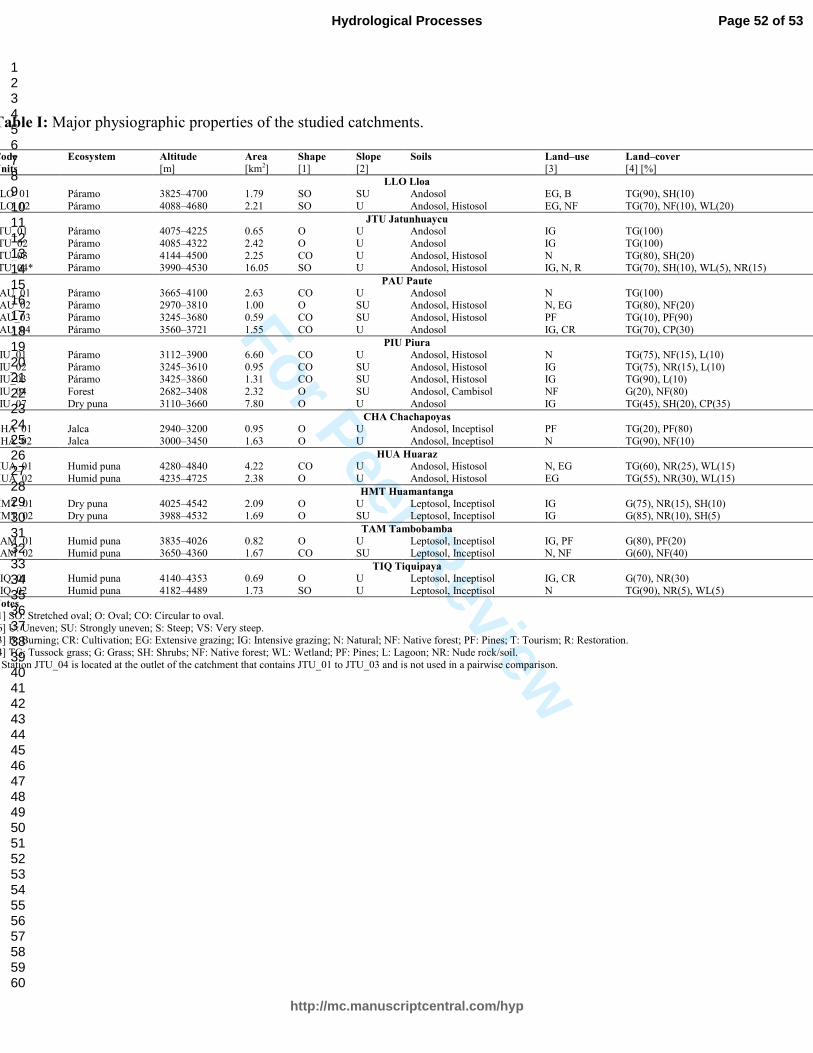
For Peer Review
Table I: Major physiographic properties of the studied catchments.
Code Ecosystem Altitude Area Shape Slope Soils Land–use Land–cover
Units [m] [km2] [1] [2] [3] [4] [%]
LLO Lloa
LLO_01 Páramo 3825–4700 1.79 SO SU Andosol EG, B TG(90), SH(10)
LLO_02 Páramo 4088–4680 2.21 SO U Andosol, Histosol EG, NF TG(70), NF(10), WL(20)
JTU Jatunhuaycu
JTU_01 Páramo 4075–4225 0.65 O U Andosol IG TG(100)
JTU_02 Páramo 4085–4322 2.42 O U Andosol IG TG(100)
JTU_03 Páramo 4144–4500 2.25 CO U Andosol, Histosol N TG(80), SH(20) JTU_04* Páramo 3990–4530 16.05 SO U Andosol, Histosol IG, N, R TG(70), SH(10), WL(5), NR(15)
PAU Paute
PAU_01 Páramo 3665–4100 2.63 CO U Andosol N TG(100) PAU_02 Páramo 2970–3810 1.00 O SU Andosol, Histosol N, EG TG(80), NF(20)
PAU_03 Páramo 3245–3680 0.59 CO SU Andosol, Histosol PF TG(10), PF(90)
PAU_04 Páramo 3560–3721 1.55 CO U Andosol IG, CR TG(70), CP(30)
PIU Piura
PIU_01 Páramo 3112–3900 6.60 CO U Andosol, Histosol N TG(75), NF(15), L(10)
PIU_02 Páramo 3245–3610 0.95 CO SU Andosol, Histosol IG TG(75), NR(15), L(10) PIU_03 Páramo 3425–3860 1.31 CO SU Andosol, Histosol IG TG(90), L(10)
PIU_04 Forest 2682–3408 2.32 O SU Andosol, Cambisol NF G(20), NF(80)
PIU_07 Dry puna 3110–3660 7.80 O U Andosol IG TG(45), SH(20), CP(35)
CHA Chachapoyas
CHA_01 Jalca 2940–3200 0.95 O U Andosol, Inceptisol PF TG(20), PF(80)
CHA_02 Jalca 3000–3450 1.63 O U Andosol, Inceptisol N TG(90), NF(10)
HUA Huaraz
HUA_01 Humid puna 4280–4840 4.22 CO U Andosol, Histosol N, EG TG(60), NR(25), WL(15)
HUA_02 Humid puna 4235–4725 2.38 O U Andosol, Histosol EG TG(55), NR(30), WL(15)
HMT Huamantanga
HMT_01 Dry puna 4025–4542 2.09 O U Leptosol, Inceptisol IG G(75), NR(15), SH(10) HMT_02 Dry puna 3988–4532 1.69 O SU Leptosol, Inceptisol IG G(85), NR(10), SH(5)
TAM Tambobamba
TAM_01 Humid puna 3835–4026 0.82 O U Leptosol, Inceptisol IG, PF G(80), PF(20) TAM_02 Humid puna 3650–4360 1.67 CO SU Leptosol, Inceptisol N, NF G(60), NF(40)
TIQ Tiquipaya
TIQ_01 Humid puna 4140–4353 0.69 O U Leptosol, Inceptisol IG, CR G(70), NR(30)
TIQ_02 Humid puna 4182–4489 1.73 SO U Leptosol, Inceptisol N TG(90), NR(5), WL(5)
Notes
[1] SO: Stretched oval; O: Oval; CO: Circular to oval.
[6] U: Uneven; SU: Strongly uneven; S: Steep; VS: Very steep. [3] B: Burning; CR: Cultivation; EG: Extensive grazing; IG: Intensive grazing; N: Natural; NF: Native forest; PF: Pines; T: Tourism; R: Restoration.
[4] TG: Tussock grass; G: Grass; SH: Shrubs; NF: Native forest; WL: Wetland; PF: Pines; L: Lagoon; NR: Nude rock/soil.
* Station JTU_04 is located at the outlet of the catchment that contains JTU_01 to JTU_03 and is not used in a pairwise comparison.
Page 52 of 53
http://mc.manuscriptcentral.com/hyp
Hydrological Processes
123456789101112131415161718192021222324252627282930313233343536373839404142434445464748495051525354555657585960

For Peer Review
Table II: Water balance and hydrometeorological features of the studied catchments.
Code Monitoring period Rainfall Discharge ET0 SINDX DAYP0 PVAR RR QVAR R2FDC IRH DLQ75 DHQ25
Units [mm year-1] [mm year-1] [mm year-1] [-] [-] [mm mm-1] [-] [mm mm-1] [-] [-] [day] [day]
LLO Lloa
LLO_01 10/01/2013–27/01/2016 1128 115 972 0.32 0.52 1.95 0.10 0.54 -0.46 0.74 8.80 8.56
LLO_02* 10/01/2013–27/01/2016 1091 144 829 0.31 0.51 1.91 0.13 0.57 -0.60 0.71 14.00 9.58
JTU Jatunhuaycu
JTU_01 14/11/2013–15/02/2016 641 59 798 0.23 0.35 1.99 0.09 0.31 -0.41 0.91 13.13 7.56
JTU_02 15/11/2013–15/02/2016 739 57 781 0.22 0.27 1.81 0.08 1.44 -0.99 0.46 8.87 4.18
JTU_03* 13/11/2013–16/02/2016 849 315 765 0.20 0.22 1.70 0.37 0.86 -0.59 0.63 7.52 4.74 JTU_04 19/11/2013–11/02/2016 767 214 817 0.22 0.27 1.85 0.28 1.05 -0.32 0.63 12.60 5.88
PAU Paute
PAU_01* 24/05/2001–16/08/2005 1358 974 937 0.14 0.20 1.40 0.72 0.85 -0.70 0.63 19.60 5.13 PAU_02* 29/02/2004–31/07/2007 1092 467 1038 0.17 0.27 1.48 0.43 0.79 -0.73 0.62 10.45 8.16
PAU_03 29/05/2004–31/07/2007 1014 201 987 0.17 0.28 1.61 0.20 1.14 -1.12 0.47 8.60 15.39
PAU_04 27/10/2001–14/10/2003 1123 688 935 0.13 0.13 1.38 0.61 1.33 -1.05 0.43 7.33 3.10
PIU Piura
PIU_01* 05/07/2013–12/12/2015 2239 1474 1275 0.19 0.24 1.58 0.66 1.09 -1.28 0.46 5.55 3.07
PIU_02 06/07/2013–13/12/2015 2677 1729 1178 0.21 0.26 1.62 0.65 1.15 -1.32 0.44 19.35 3.98 PIU_03 11/04/2013–23/10/2015 1869 1103 1165 0.22 0.23 1.68 0.59 1.85 -1.63 0.18 5.67 54.50
PIU_04* 23/06/2013–14/01/2016 1377 614 1374 0.31 0.40 2.12 0.45 1.05 -0.70 0.52 8.86 22.71
PIU_07* 11/07/2013–15/01/2015 640 173 1268 0.51 0.67 2.86 0.27 1.58 -0.48 0.40 15.22 11.42
CHA Chachapoyas
CHA_01 18/08/2010–07/12/2015 634 118 1294 0.19 0.32 1.61 0.19 1.06 -0.71 0.52 4.11 5.23
CHA_02* 18/08/2010–07/12/2015 930 560 1266 0.15 0.25 1.43 0.60 0.57 -0.36 0.75 3.86 2.36
HUA Huaraz
HUA_01* 10/09/2012–20/06/2014 1346 937 984 0.37 0.26 1.36 0.70 1.05 -2.06 0.43 39.50 9.29
HUA_02 10/09/2012–20/06/2014 1288 726 1015 0.36 0.26 1.32 0.56 1.12 -2.22 0.38 20.13 14.55
HMT Huamantanga
HMT_01 28/06/2014–03/03/2016 645 168 902 0.48 0.69 2.47 0.26 2.72 -3.33 0.02 8.11 25.50 HMT_02* 26/06/2014–03/03/2016 613 138 964 0.50 0.68 2.60 0.23 2.51 -2.19 0.06 8.56 30.60
TAM Tambobamba
TAM_01 12/04/2012–02/01/2013 1245 244 1250 0.49 0.66 2.38 0.20 0.98 -0.95 0.49 11.33 17.50 TAM_02* 12/04/2012–16/04/2013 1405 811 1299 0.48 0.63 2.36 0.58 0.67 -0.57 0.67 17.00 35.00
TIQ Tiquipaya
TIQ_01 02/04/2013–25/01/2016 835 244 1146 0.42 0.59 2.36 0.29 2.17 -1.99 0.15 5.86 7.65
TIQ_02* 18/02/2013–25/01/2016 871 263 1102 0.45 0.61 2.36 0.30 2.12 -0.58 0.35 16.69 20.62
Notes
* Reference catchments. Average monthly precipitation and discharge for these are plotted in Figure 1.
See Table III for the definitions of the analysed hydrological indices.
Page 53 of 53
http://mc.manuscriptcentral.com/hyp
Hydrological Processes
123456789101112131415161718192021222324252627282930313233343536373839404142434445464748495051525354555657585960

For Peer Review
Table III: Definition of the hydrological indices analysed in the study.
Abbreviation Reference formula Units Definition
Indices related to meteorological features
0 0.0023(Tmean+17.8)(Tmax−Tmin )0.5Ra [mm year-1] Reference evapotranspiration based on monthly temperature estimates only.
SINDX (1/Pyear)(Σ|Pmonth–Pyear|/12)(6/11) [-] Seasonality index scaled between 0 (non-seasonal, all months with equal rainfall) to 1 (extremely seasonal, all annual rainfall
occurring during one month). DAYP0 DP<RGres/Dtotal [-] Percentage of days with zero precipitation (i.e. not registered by the rain gauge resolution) with respect to the total number of
days over the monitored period.
PVAR σP/Pmean [mm mm-1] Coefficient of variation in daily precipitation over the monitored period, standard deviation divided by mean.
Indices related to streamflow features RR Qyear/Pyear [-] Ratio between average discharge volume and average rainfall volume over the monitored period.
QVAR σQ/Qmean [mm mm-1] Coefficient of variation in daily flows over the monitored period, standard deviation divided by mean.
R2FDC (log10(Q66)–log10(Q33))/(0.66–0.33) [-] Slope in the middle third of the flow duration curve in logarithmic scale.
IRH Σ(QQ<Q50)/Σ(Q) [-] Volume below the 50th flow percentile (Q50) in the flow duration curve divided by total volume.
DLQ75 Σ(DQ<Q25)/NQ<Q25 [day] Average duration of flows below the 25th flow percentile (Q75) over the monitored period.
QHQ25 Σ(DQ>Q75)/NQ>Q75 [day] Average duration of flows above the 75th flow percentile (Q25) over the monitored period.
Page 54 of 53
http://mc.manuscriptcentral.com/hyp
Hydrological Processes
123456789101112131415161718192021222324252627282930313233343536373839404142434445464748495051525354555657585960