For official use Technical Report Series
21
DISTRICT GROUNDWATER BROCHURE VIRUDHUNAGAR DISTRICT, TAMIL NADU By A. Balachandran, Scientist-D Government of India Ministry of Water Resources Central Ground Water Board South Eastern Coastal Region Chennai May 2009 For official use Technical Report Series
Transcript of For official use Technical Report Series

DISTRICT GROUNDWATER BROCHURE
VIRUDHUNAGAR DISTRICT, TAMIL NADU
By
A. Balachandran,
Scientist-D
Government of India
Ministry of Water Resources
Central Ground Water Board South Eastern Coastal Region
Chennai
May 2009
For official use
Technical Report Series

i
DISTRICT AT A GLANCE (VIRUDUNAGAR DISTRICT)
S. No. ITEMS STATISTICS
1. GENERAL INFORMATION
i. Geographical area (Sq. km) 4243.23
ii. Administrative Divisions (As on 31-3-2007)
Number of Taluks
Number of Blocks
Number of Villages
8
11
600
iii. Population (2001 Census)
Total Population
Male
Female
1751301
870376
880925
iv. Average Annual Rainfall (mm) (1901-2000) 799.8
GEOMORPHOLOGY
i. Major physiographic Units Structural hills, Deep Burried
Pediments, Shallow Burried
Pediments, Bazada and Flood
Plain .
2.
ii. Major Drainages Vaippar, Gundar, & Arjuna
Nadhi.
3. LAND USE (Sq. km) (2005-06)
i. Forest area
ii. Net area sown
iii. Cultivable waste
264.66
1428.82
96.63
4. MAJOR SOIL TYPES 1. Deep red loam, 2. Black soil,
3. Red sandy soil.
5. AREA UNDER PRINCIPAL CROPS (Ha)
(2005-2006)(Figures is bracket are % to the total
Geographical area of the district)
1. Paddy -30433 (50.6%)
2. Groundnut – 467 (0.78%)
3. Pulses – 467 (0.78%)
4. Sugarcane – 3209 (5.33%) 6. IRRIGATION BY DIFFERENT SOURCES (2005-06) Number Area irrigated (Ha)
i. Dug wells 36087 33765
ii. Tube wells 0 0
iii. Tanks 997 26423
iv. Canals 0 0
vi. Net irrigated area 55365 Ha
vii. Gross irrigated area 60188 Ha
ii
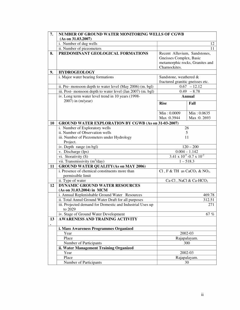
NUMBER OF GROUND WATER MONITORING WELLS OF CGWB
(As on 31.03.2007)
i. Number of dug wells 12
7.
ii. Number of piezometers 11
8. PREDOMINANT GEOLOGICAL FORMATIONS Recent Alluvium, Sandstones,
Gneisses Complex, Basic metamorphic rocks, Granites and
Charnockites.
9. HYDROGEOLOGY
i. Major water bearing formations Sandstone, weathered &
fractured granitic gneisses etc.
ii. Pre- monsoon depth to water level (May 2006) (m. bgl) 0.67 – 12.12
iii. Post- monsoon depth to water level (Jan 2007) (m. bgl) 0.49 – 8.78
Annual
Rise Fall
iv. Long term water level trend in 10 years (1998-
2007) in (m/year)
Min : 0.0009
Max :0.3944
Min : 0.0635
Max :0. 2693
10 GROUND WATER EXPLORATION BY CGWB (As on 31-03-2007)
i. Number of Exploratory wells
ii. Number of Observation wells
iii. Number of Piezometers under Hydrology
Project.
26
5
11
iv. Depth range (m bgl) 120 – 200
v. Discharge (lps) 0.004 – 1.142
vi. Storativity (S) 3.41 x 10⁻⁵
-0.7 x 10⁻²
vii. Transmissivity (m2/day) 1 – 518.3
11 GROUND WATER QUALITY(As on MAY 2006)
i. Presence of chemical constituents more than
permissible limit
Cl , F & TH as CaCO3 & NO3.
ii. Type of water Ca-Cl , NaCl & Ca-HCO3
12 DYNAMIC GROUND WATER RESOURCES
(As on 31.03.2004) in MCM
i. Annual Replenishable Ground Water Resources 469.78
ii. Total Annul Ground Water Draft for all purposes 312.51
iii. Projected demand for Domestic and Industrial Uses up
to 2029
271
iv. Stage of Ground Water Development 67 %
13
.
AWARENESS AND TRAINING ACTIVITY
i. Mass Awareness Programmes Organized
Year 2002-03
Place Rajapalayam.
Number of Participants 300
ii. Water Management Training Organized
Year 2002-03
Place Rajapalayam.
Number of Participants 30
iii
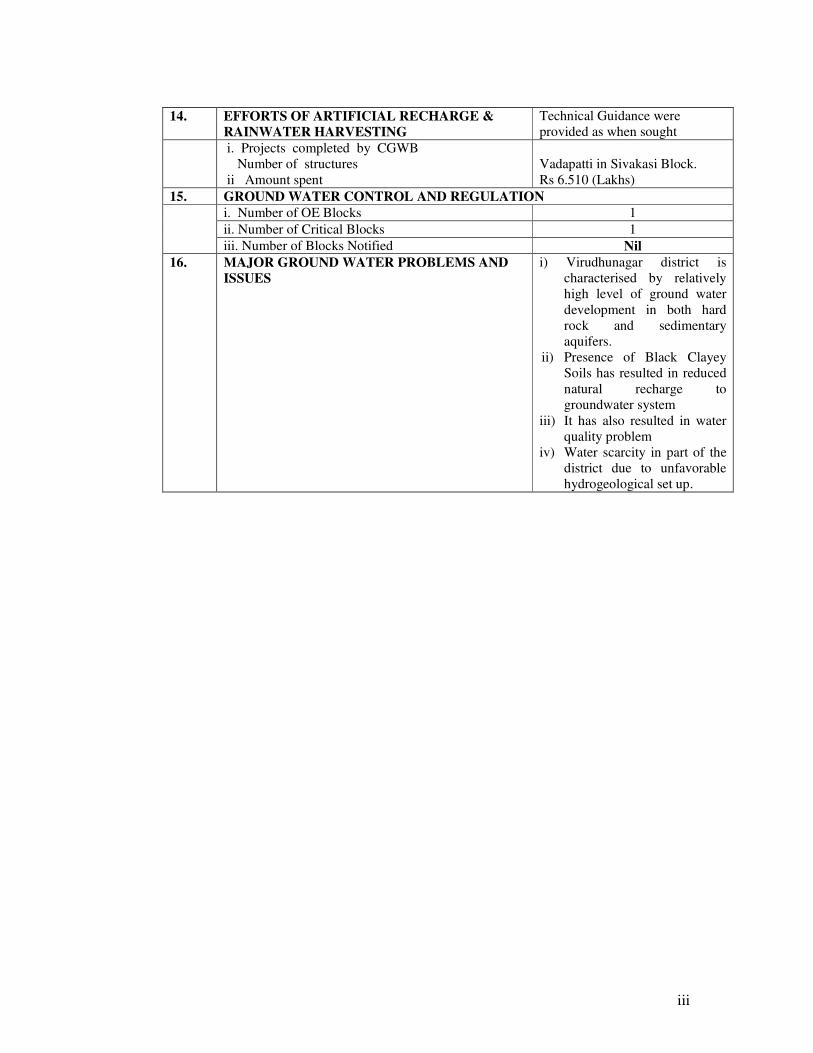
14. EFFORTS OF ARTIFICIAL RECHARGE &
RAINWATER HARVESTING
Technical Guidance were
provided as when sought
i. Projects completed by CGWB
Number of structures
ii Amount spent
Vadapatti in Sivakasi Block.
Rs 6.510 (Lakhs)
15. GROUND WATER CONTROL AND REGULATION
i. Number of OE Blocks 1
ii. Number of Critical Blocks 1
iii. Number of Blocks Notified Nil
16. MAJOR GROUND WATER PROBLEMS AND
ISSUES
i) Virudhunagar district is
characterised by relatively
high level of ground water
development in both hard
rock and sedimentary
aquifers.
ii) Presence of Black Clayey
Soils has resulted in reduced
natural recharge to
groundwater system
iii) It has also resulted in water
quality problem
iv) Water scarcity in part of the
district due to unfavorable
hydrogeological set up.
1
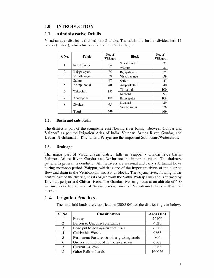
1.0 INTRODUCTION
1.1. Administrative Details
Virudhunagar district is divided into 8 taluks. The taluks are further divided into 11
blocks (Plate-I), which further divided into 600 villages.
S. No. Taluk No. of
Villages Block
No. of
Villages
Srivalliputtur 31 1 Srivilliputtur 54
Watrap 23
2 Rajapalayam 35 Rajapalayam 35
3 Virudhunagar 59 Virudhunagar 59
4 Sathur 47 Sathur 47
5 Aruppukottai 40 Aruppukottai 40
Thiruchuli 100 6 Thiruchuli 192
Narikudi 92
7 Kariyapatti 108 Kariyapatti 108
Sivakasi 29 8 Sivakasi 65
Vembakottai 36
Total 600 600
1.2. Basin and sub-basin
The district is part of the composite east flowing river basin, “Between Gundar and
Vaippar” as per the Irrigation Atlas of India. Vaippar, Arjuna River, Gundar, and
Deviar, Nichibanadhi, Kovilur and Periyar are the important Sub-basins/Watersheds.
1.3. Drainage
The major part of Virudhunagar district falls in Vaippar - Gundar river basin.
Vaippar, Arjuna River, Gundar and Deviar are the important rivers. The drainage
pattern, in general, is dendritic. All the rivers are seasonal and carry substantial flows
during monsoon period. Vaippar, which is one of the important rivers of the district,
flow and drain in the Vembakkam and Sattur blocks. The Arjuna river, flowing in the
central part of the district, has its origin from the Sattur Watrap Hills and is formed by
Kovillar, periyar and Chittar rivers. The Gundar river originates at an altitude of 500
m. amsl near Kottaimalai of Saptur reserve forest in Varushanadu hills in Madurai
district
1. 4. Irrigation Practices
The nine-fold lands use classification (2005-06) for the district is given below.
S. No. Classification Area (Ha)
1 Forests 26466
2 Barren & Uncultivable Lands 4525
3 Land put to non agricultural uses 70286
4 Cultivable Waste 9663
5 Permanent Pastures & other grazing lands 804
6 Groves not included in the area sown 6568
7 Current Fallows 3063
8 Other Fallow Lands 160066
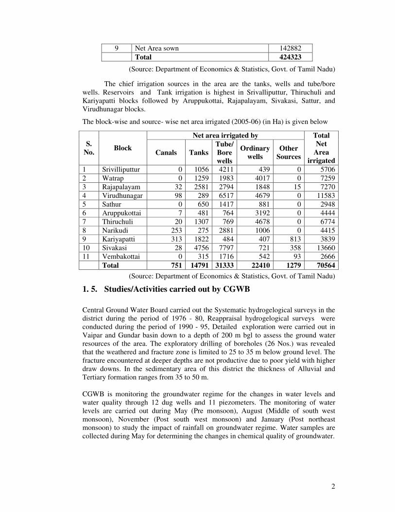
2
9 Net Area sown 142882
Total 424323
(Source: Department of Economics & Statistics, Govt. of Tamil Nadu)
The chief irrigation sources in the area are the tanks, wells and tube/bore
wells. Reservoirs and Tank irrigation is highest in Srivalliputtur, Thiruchuli and
Kariyapatti blocks followed by Aruppukottai, Rajapalayam, Sivakasi, Sattur, and
Virudhunagar blocks.
The block-wise and source- wise net area irrigated (2005-06) (in Ha) is given below
Net area irrigated by
S.
No. Block
Canals Tanks
Tube/
Bore
wells
Ordinary
wells
Other
Sources
Total
Net
Area
irrigated
1 Srivilliputtur 0 1056 4211 439 0 5706
2 Watrap 0 1259 1983 4017 0 7259
3 Rajapalayam 32 2581 2794 1848 15 7270
4 Virudhunagar 98 289 6517 4679 0 11583
5 Sathur 0 650 1417 881 0 2948
6 Aruppukottai 7 481 764 3192 0 4444
7 Thiruchuli 20 1307 769 4678 0 6774
8 Narikudi 253 275 2881 1006 0 4415
9 Kariyapatti 313 1822 484 407 813 3839
10 Sivakasi 28 4756 7797 721 358 13660
11 Vembakottai 0 315 1716 542 93 2666
Total 751 14791 31333 22410 1279 70564
(Source: Department of Economics & Statistics, Govt. of Tamil Nadu)
1. 5. Studies/Activities carried out by CGWB
Central Ground Water Board carried out the Systematic hydrogelogical surveys in the
district during the period of 1976 - 80, Reappraisal hydrogelogical surveys were
conducted during the period of 1990 - 95, Detailed exploration were carried out in
Vaipar and Gundar basin down to a depth of 200 m bgl to assess the ground water
resources of the area. The exploratory drilling of boreholes (26 Nos.) was revealed
that the weathered and fracture zone is limited to 25 to 35 m below ground level. The
fracture encountered at deeper depths are not productive due to poor yield with higher
draw downs. In the sedimentary area of this district the thickness of Alluvial and
Tertiary formation ranges from 35 to 50 m.
CGWB is monitoring the groundwater regime for the changes in water levels and
water quality through 12 dug wells and 11 piezometers. The monitoring of water
levels are carried out during May (Pre monsoon), August (Middle of south west
monsoon), November (Post south west monsoon) and January (Post northeast
monsoon) to study the impact of rainfall on groundwater regime. Water samples are
collected during May for determining the changes in chemical quality of groundwater.

3
2. 0. RAINFALL AND CLIMATE
The district receives the rain under the influence of both southwest and northeast
monsoons. The northeast monsoon chiefly contributes to the rainfall in the district.
Most of the precipitation occurs in the form of cyclonic storms caused due to the
depressions in Bay of Bengal. The southwest monsoon rainfall is highly erratic and
summer rains are negligible. Rainfall data from seven stations over the period 1901-
2000 were utilized for analysis and a perusal of the data shows that the normal annual
rainfall over the district varies from about 724 to 913 mm. It is minimum around
Sathur in the southeastern part of the district. It gradually increases towards west,
north and northwest and attains a maximum around Watrap.
The district enjoys a subtropical climate. The period from April to June is generally
hot and dry. The weather is pleasant during the period from November to January.
Usually mornings are more humid than afternoons. The relative humidity is on an
average between 65 and 85% in the mornings. Humidity in the afternoon is generally
between 40 and 70%.
The annual mean minimum and maximum temperatures are 23.78 and 33.95° C
respectively. The daytime heat is oppressive and the temperature is as high as 40.2° C.
The lowest temperature recorded is of the order of 19.3° C.
3. 0. GEOMORPHYLOGY AND SOIL TYPES
3. 1. Geomorphology
Virudhunagar district is bordered by Western Ghats (Ridge and valley complex) in the
West. Vally fill area is observed in Watrap block. A major part of the district
constitutes a plain terrain with a gentle slope toward East and Southeast, except for
the hilly terrain in the west.
The prominent geomorphic units identified in the district through interpretation of
Satellite imagery are; 1. Flood Plain, 2. Bazada, 3. Pediment, 4. Shallow & deep
buried Pediments and 6. Structural Hills.
3. 2. Soils
Soils in the area have been classified into i) Deep red Loam ii) Black soil iii) Red
sandy soil. The majority of the study area is covered by Black soil. Ferruginous red
soils are also seen at places. Black soils are deep to very deep and generally occurs in
the depressions adjacent to hilly areas, in the western and central part of district.
Alluvial soils occur along the river courses. Red sandy soil is seen all around the
Sattur, Kariyapatti, Aruppukotai and Thiruchuli blocks.
4. 0. GROUND WATER SCENARIO
4. 1. Hydrogeology
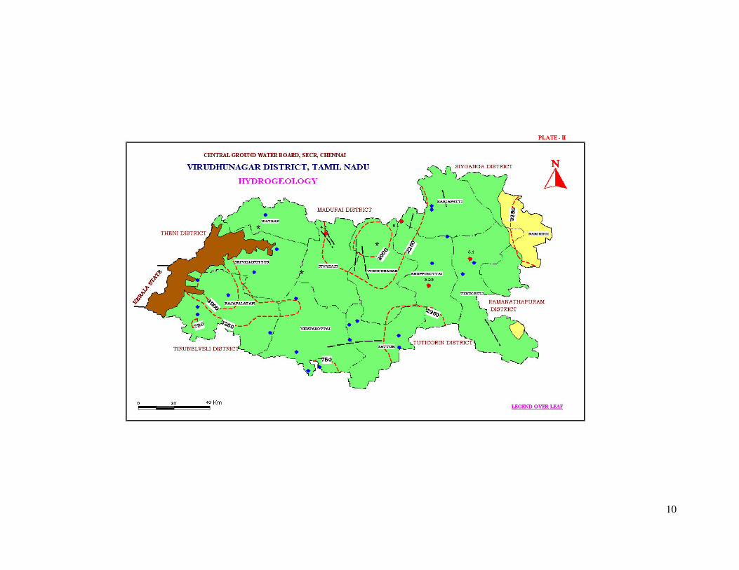
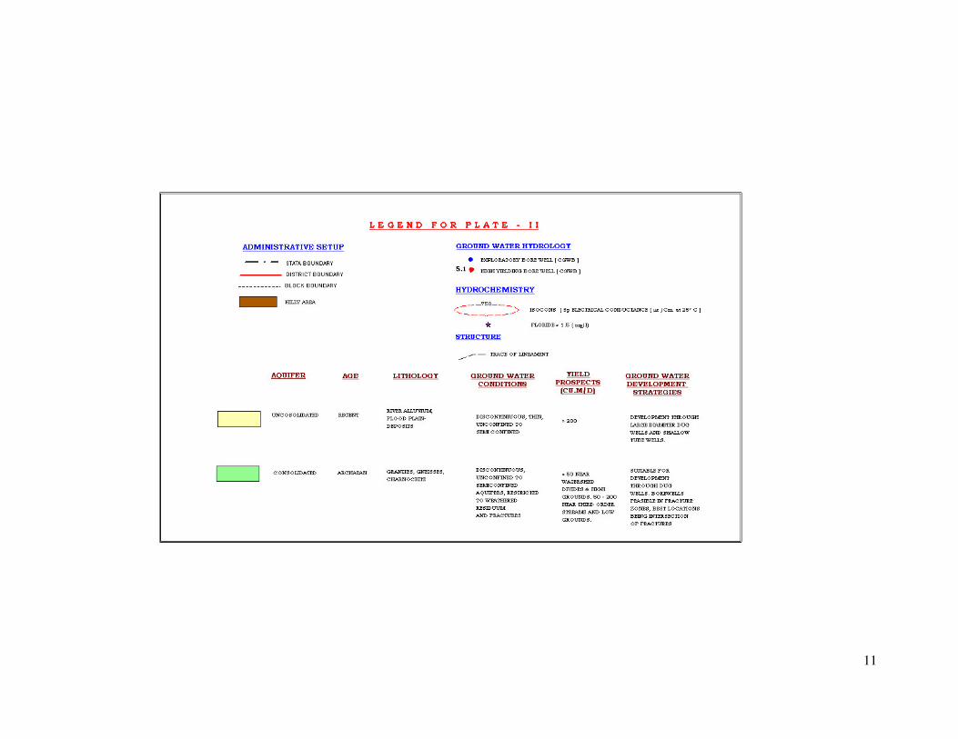
The district is underlain by both porous and fissured formations (Plate-II).
Unconsolidated & Semi-consolidated formations and Weathered, Fissured and

4
Fractured crystalline rocks constitute the important aquifer systems in the district.
The porous formations in the district include sandstones and clays of Recent to sub-
recent and Tertiary age (Quaternary).The alluvial formations comprising mainly
sands, clays and gravels are confined to major drainage courses in the district.The
maximum thickness of alluvium is 35.0 m. whereas the average thickness is about
25.0 m. Ground water occurs under phreatic to semi-confined conditions in these
formations and is being developed by means of dug wells and filter points. Alluvium,
which forms a good aquifer system along the Vaippar and Gundar river bed, which is
one of the major sources of water supply to the villages.
The water-bearing properties of crystalline formations, which lack primary porosity,
depend on the extent of development of secondary intergranular porosity . The
occurrence and movement of ground water in these rocks are generally confined to
such spaces. These aquifers are highly heterogeneous in nature due to variation in
lithology, texture and structural features even within short distances. Ground water
generally occurs under phreatic conditions in the weathered mantle and under semi-
confined conditions in the fissured and fractured zones at deeper levels.
The thickness of weathered zone in the district is in the range of 4 to 15 m. The depth
of dug wells ranged from 10 to 15 m bgl. The yield of large diameter wells in the
district, tapping the weathered mantle of crystalline rocks ranges from 40 to 110 lpm
and are able to sustain pumping for 2 to 6 hours per day. The Specific capacity of
large diameter wells tested in crystalline rocks ranges from 6.26 to 183.8 lpm / m. of
drawdown. The yield characteristics of wells vary considerably depending on the
topographic set-up, lithology and nature of weathering.
The yield of bore wells drilled down to a depth of 40 to 70 m, by various state
agencies mainly for domestic purposes ranged from 10 to 250 lpm. The yield of
successful bore wells ranged up to 6 lps for the drawdown varying between 5.76 and
17.56 m and drilled down to a depth of 200 m bgl during the ground water exploration
programme of Central Ground Water Board..
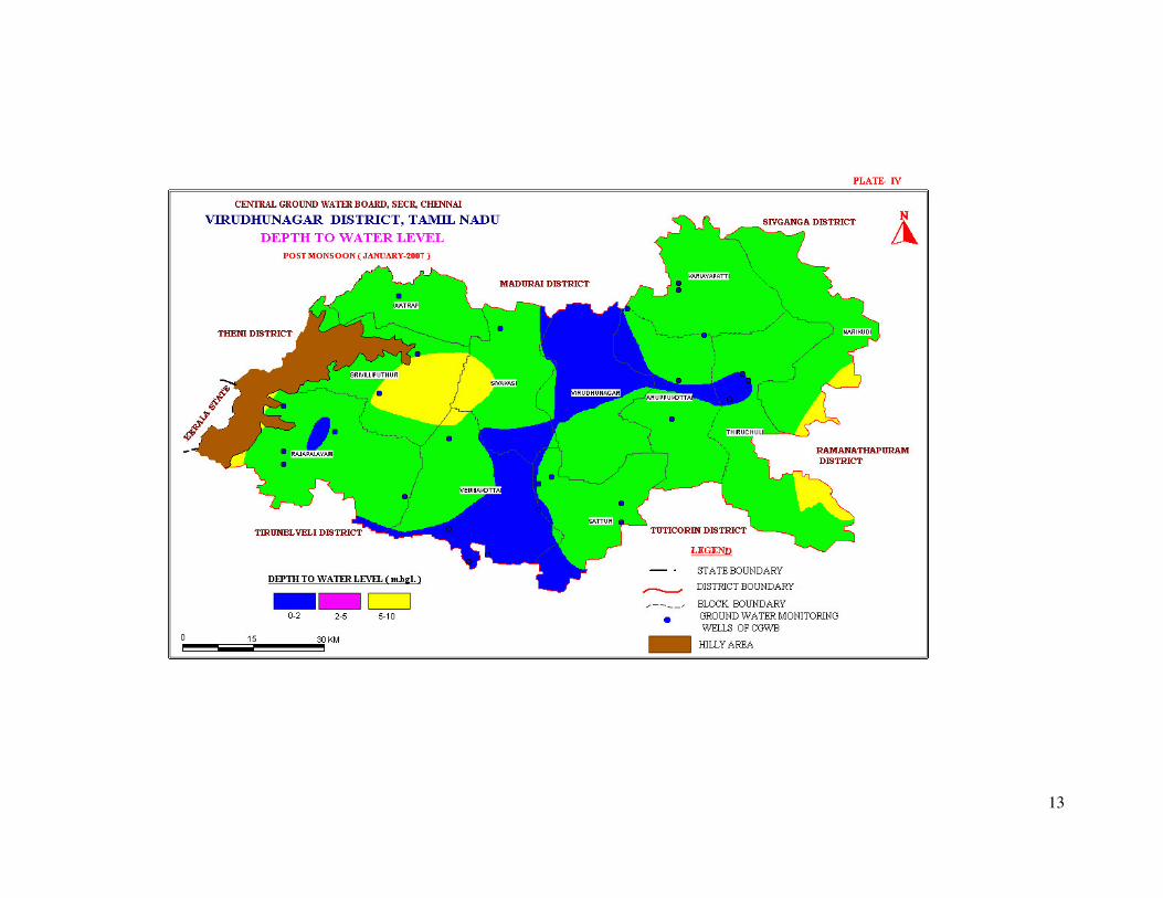
The depth to water level in the district varied between 0.67 and 12.12 m bgl during
pre-monsoon (May 2006) and varied between 0.49 and 8.78 m bgl during post
monsoon (Jan 2007). The seasonal fluctuation shows a rise in water level which
ranges from 0.35 to 2.8 m. The piezometric head varied between 3.49 and 16.23 m
bgl during pre monsoon (May 2006) and 1.29 and 8.06 m bgl during post monsoon
(Jan 2007).
4. 1. 1. Long Term Fluctuation (1998-2007)
The long term water level fluctuation for the period 1998-2007 is indicates rise in
water level in the range of 0.0009 - 0.3944 m/year. The fall in water level ranging
between 0.0635 and 0.2693 m/year.
4. 1. 2. Aquifer Parameters
Formation Transmissivity
(m2/day)
Storativity Specific Yield
(%)
Weathered Crystallines - - <2
Fractured Crystallines 1-548 3.41X10⁻⁵
to
7.0X10⁻³
-

5
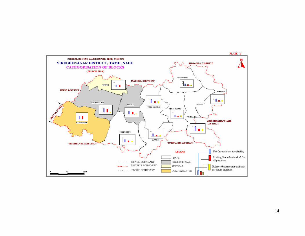
4. 2. Ground Water Resources
The ground water resources have been computed jointly by Central Ground Water
Board and State Ground & Surface Water Resources and Data Centre (PWD, WRO,
Government of Tamil Nadu) as on 31st March 2004. The salient features of the
computations are furnished below. The computation of ground water resources
available in the district has been done using GEC 1997 methodology.
Block
Net
Groundwater
Availability
(M.Cu.m)
Existing
Gross
Draft for
Irrigation
(M.Cu.m)
Existing
Gross
Draft for
Domestic
and
industrial
water
supply
(M.Cu.m)
Existing
Gross
Draft for
all uses
(M.Cu.m)
Allocation
for Domestic
and
Industrial
Requirement
supply upto
next 25 years
(2029)
(M.Cu.m)
Net
groundwatre
Availability
for future
Irriation
Development
(M.Cu.m)
Stage of
Groundwater
Development
(%)
Category
of Block
Srivilliputtur 45.30 36.89 20.40 38.93 23.3 62.8 86
Semi
Critical
Watrap 52.27 49.03 25.80 51.6 26.8 0.55 99 Critical
Rajapalayam 67.37 65.48 20.2 67.5 21.1 -0.22 100
Over
Exploited
Virudhunagar 36.17 14.20 30.4 17.24 31.7 18.80 48 Safe
Sathur 26.13 87.60 19.30 10.69 20.1 15.36 41 Safe
Aruppukottai 26.33 86.30 18.00 10.43 18.8 15.82 40 Safe
Thiruchuli 47.35 19.87 18.00 21.66 18.7 25.61 46 Safe
Narikudi 59.86 25.94 16.8 27.62 17.5 32.16 46 Safe
Kariyapatti 50.36 25.93 19.1 27.84 20.0 22.43 55 Safe
Sivakasi 31.82 18.85 46.30 23.48 48.3 8.14 74
Semi
Critical
Vembakottai 26.82 13.14 23.7 15.51 24.7 11.22 58 Safe
Total 469.78 443.23 258.00 312.5 271.00 212.67 66.52
4. 3. Ground Water Quality
The chemical characteristics of ground water in the phreatic zone in Virudhunagar
district has been studied using the analytical data of ground water samples collected
from Ground water monitoring wells of Central Ground Water Board. The study of
quality of ground water in deeper aquifers in the district has been attempted using the
data collected from exploratory bore/tube wells constructed in the district. Ground
water in phreatic aquifers in Virudhunagar district, in general, is colourless, odourless
and slightly alkaline in nature. The specific electrical conductance of ground water in
phreatic zone (in Micro Seimens at 25o C) during May 2006 was in the range of 409 to
4350 in the district. It is between 750 and 2250 µS/Cm at 25o
C in the major part of
the district. Conductance below 750 µS/Cm at 25o
C have been observed in ground
water in parts of Sathur and Watrap blocks, whereas conductance exceeding 2250
µS/Cm at 25o
C have been observed in part of Rajapalayam and Virudhunagar blocks.
It is observed that the ground water is suitable for drinking and domestic uses in
respect of all the constituents except Total Hardness and Nitrate. Total Hardness as
CaCO3 is observed to be in excess of permissible limits of treating water standard of
BU in about 49 percent of samples analyzed whereas Nitrate is found in excess of 45
mg/l in about 30 percent samples analyzed. The incidence of high Total Hardness is

6
attributed to the composition of lithounits constituting the aquifers in the district.
Whereas the Nitrate pollution is most likely due to the use of pesticides and fertilizers
for agriculture. With regard to irrigation suitability based on specific electrical
conductance and Sodium Absorption Ratio (SAR), it is observed that ground water in
the phreatic zone may cause high to very high salinity hazard and medium to high
alkali hazard when used for irrigation. Proper soil management strategies are to be
adopted in the major part of the district while using ground water for irrigation.
4. 4. Status of Ground Water Development
The estimation of groundwater resources of the district shows that one block is over
exploited and one block is under “critical” category.
The shallow alluvial aquifers along Vaippar and Gundar rivers serve as an important
source of drinking water and irrigation development of Virudhunagar district. Dug
wells are the most common ground water abstraction structures used for irrigation in
the district. The yield of dug wells range from <50 to 200 m3/day in weathered
crystalline rocks, 20 to 100 m3/day in Tertiary formations and upto 400 m
3/day in
Recent alluvial formations along major drainage courses. The dug wells in hard rock
terrain tapping the entire weathered residuum are capable of yielding 6 – 7 lps,
requiring the installation of 5 HP centrifugal pumps for extraction of ground water.
5. 0. GROUNDWATER MANAGEMENT STRATEGY
5. 1. Groundwater Development
In view of the presence of balck top soil in the major parts of the district, the recharge
potentials are very low an dit has also resulted in quality problem. Hence, it is
necessary to exercise causion while planning further devlopment of available
groundwater resources in the district. The yields of dug wells in crystalline and
Tertiary formations can be improved at favorable locations by construction of
extension bores and radial arms respectively to a length of 20-30 m. In recent years,
farmers for irrigation purposes have also drilled a large number of bore wells.The
development of ground water for irrigation in the district is mainly through dug wells
tapping the weathered residuum or recent alluvial deposits. Bore wells have also
become popular as the source for irrigation in the district in recent years. Dug wells
with extension bores wherever necessary is ideal for hard rock areas whereas large
diametert dug wells with radials is suitable for alluvial areas.
The map showing the development prospects for the district is shown in Plate- VI.
5. 2. Water Conservation and Artificial Recharge
CGWB had prepared a master plan to augment groundwater potential by saturating
the shallow aquifer taking into consideration the available unsaturated space during
post monsoon and available uncommitted surplus run off. Subsequently, computations
have been made for Drought Prone Area Program (DPAP) for over exploited and
critical blocks in the districts warranting immediate attention. Institute of Remote
Sensing, Anna University had prepared block wise maps demarcating potential zones
for artificial recharge for the State of Tamil Nadu. Subsequently, State Government

7
agencies have constructed artificial recharge structures with their own fund or with
fund from Central Government, dovetailing various government programs.
Ministry of Water Resources, Government of India has initiated Dug Well Recharge
Scheme in the State. The scheme is being implemented by the Nodal Department
(SG&SWRDC, PWD, WRO, Government of Tamil Nadu) with the technical
guidance of CGWB. The subsidy of Rs. 4000/- for small and marginal farmers and
Rs. 2000/- for the other farmers is credited to the beneficiaries’ bank account through
NABARD. The scheme after implementation will prove to be beneficial to the
irrigation sector. The available uncommitted surplus run off has to be recomputed,
taking into consideration the quantum of recharge effected through existing irrigation
dug wells also. The existing structures and uncommitted surplus flow should be
considered for further planning of artificial recharge program.
On the basis of experimental studies, it has been found that de-silting of existing tanks
followed by percolation pond with recharge wells, recharge shafts are economical.
There is considerable scope for implementation of roof – top rainwater harvesting in
the district. Recharge pits / Shafts / trenches of suitable design are ideal structures for
rainwater harvesting in such areas. Central Ground Water Board is also providing
free technical guidance for implementation of rooftop rainwater harvesting schemes.
A map showing the development prospects and Artificial recharge structures
recommended for various blocks in Virudhunagar district are shown in Plate-VI.
6. 0. GROUND WATER RELATED ISSUES & PROBLEMS
In view of the top black soil in the major parts of the district, the recharge potentials
are very low and it has also resulted in water quality problems.
7. 0. Awareness & Training Activity
7. 1. Mass Awareness Campaign (MAP) & Water Management
Training Programme (WMTP) by CGWB
One Mass Awareness Campaign on “Ground Water Management, Regulation &
Conservation” was organized at Rajapalayam, Virudhunagar district during the period
2002-03 . One WMTP was organized on “Rain Water Harvesting Training” at the
meeting hall of District Collectorate complex, Rajapalayam in Virudhunagar district
during the period 2002-03.
8. 0. AREA NOTIFIED BY CGWA/SGWA
Central Ground Water Authority has not notified any area in the district. Government
of Tamil Nadu vide G.O. No. 53 has banned groundwater development for irrigation
in the over exploited blocks of Tamil Nadu. The over exploited block in this district is
Rajapalayam.
8
9. 0 RECOMMENDATIONS
In view of the top black soil in the major parts of the district, the recharge potentials
are very low and it has also resulted in water quality problems. In order to increase the
recharge, tanks, percolation ponds may be provided with the recharge wells/recharge
shafts penetrating this impervious layer to make it more effective in recharging the
aquifer.
Waste land development program and micro irrigation system area to be implemented
for increasing the agricultural produces to attain more food and income per drop of
water in view of the limited water resources in the districts.

9
10
11

12
13
14

15

16
LEGEND FOR PLATE - VI
DISTRICT – VIRUDUNAGAR
OTHER INFORMATION
Geographical Area 4243.23 Sq. Km.
Number of Blocks 11
Major Drainage Vaipar Gundar & Arjuna Nadhi
Population (2001) 17,51,301
Average Annual Rainfall 799.8 Mm
Annual Range of Temperature 24 –40° C
Regional Geology Soft Rocks: Clay, Sandstone & Shale
Hard Rocks: Granites & Gneisses
Net Ground Water Availability for Future Irrigation 212.67 MCM/Yr
Stage Of Ground Water Development As on January 2003 66.52 %
Name of Blocks Showing Intensive Ground Water Development Over Exploited Rajapalayam
Critical: Watrap
Wells Feasible Rigs Suitable Depth of
Well (mbgl)
Discharge
(LPM)
Suitable Artificial
Recharge Structures
Soft Rock Aquifer
Dug Well Manual 10-15 10 - 60 Percolation Ponds With
Recharge Shaft
Hard Rock Aquifer
Dug Well
Manual
10-15
10 - 60 Check Dams/ Percolation
Ponds With Recharge
Shaft
Hard Rock Aquifer
Dug Well
Dug Cum Bore Well
Bore Well
Manual
Manual + DTH
DTH
10-15
10 - 15+40
60-90
60 - 180 Check Dams/ Percolation
Ponds With Recharge
Shaft
District Boundary Block Boundary
District Headquarter
Block Headquarters
5 Water Level-Pre-Monsoon (Decadal Mean
1993-2002) Mbgl
1250 Ec in Microsiemens / Cm at 25° C
River Lineament
Hilly Area Nitrate Greater Than Maximum Permissible
Limit (45 mg/l)
Published by : Regional Director, CGWB, SECR, E-1, Rajaji Bhavan, Besant Nagar, Chennai-90
�+914424912941/24914494 �/Fax : 91 4424914334 Web: www.cgwb.gov.in