For Hand Written Notes Contact @ [email protected] … · Blackbuck poaching case: Salman...
112
For Hand Written Notes Contact @ [email protected] Contact No: +918290909894 vmentoracademy.com examtrix.com
Transcript of For Hand Written Notes Contact @ [email protected] … · Blackbuck poaching case: Salman...

For Han
d Writt
en N
otes C
ontac
t @ vm
entor
acad
emy@
gmail
.com
Contac
t No:
+918
2909
0989
4
vmentoracademy.com examtrix.com

Website: www.prepmate.in Telegram Channel: @upscprepmate
Prepmate Cengage Books Preview: https://prepmate.in/books/ Youtube channel: PrepMateEdutech
Table of Contents
Geography ........................................................................................ 1
1. Cyclonic Storm OCKHI over south Kerala coast and neighborhood ........................................ 1
2. All about Mount Agung volcano eruption in Bali, Indonesia ....................................................... 2
3. 3. A Concise study/guide about the unusual storm (Ockhi) ........................................................ 3
4. Re-curving of cyclones ................................................................................................................................. 4
5. All you need to know about urban heat island effect ...................................................................... 6
6. Analysis of the cyclone Ockhi ..................................................................................................................... 9
7. Jakarta sinking fast? Here is why the Indonesian capital will soon be under water ..... 11
8. 2017 Was One of the Hottest Years on Record ............................................................................... 13
9. Total Eclipse of Moon to take place on January 31 ....................................................................... 15
10. How storms and lightning in North India killed over a hundred in just a day .................. 16
11. NWIC setup as a single window source of updated data on water resources ................... 17
12. Mumbai, where a development plan for the future is stirring debate ................................ 18
13. Zojila tunnel to bring Srinagar, Kargil and Leh closer ................................................................ 20
14. Why have monsoons been fierce so far? ............................................................................................ 21
15. Why the longest day occurs on 21st June .......................................................................................... 22
16. Rain check: June nearly normal ............................................................................................................ 24
17. Century s Longest Total Lunar Eclipse on July 27-28 .................................................................. 27
18. Meghalayan : How a North East cave rock formation now defines our Age.................... 28
Environment .................................................................................. 33
1. High Ash content ........................................................................................................................................... 33
2. Measures to Stop /Prevent Underground Fire in Coal Mines .................................................... 34
3. Changes in Cryosphere affecting Global Climate .......................................................................... 34
For Han
d Writt
en N
otes C
ontac
t @ vm
entor
acad
emy@
gmail
.com
Contac
t No:
+918
2909
0989
4
vmentoracademy.com examtrix.com
Website: www.prepmate.in Telegram Channel: @upscprepmate
Prepmate Cengage Books Preview: https://prepmate.in/books/ Youtube channel: PrepMateEdutech
4. World Wetlands Day ................................................................................................................................... 35
5. All-India Tiger Estimation 2018 to be Hi-Tech, More Accurate and Precise .................... 37
6. India State of Forest Report 2017 Released .................................................................................... 38
7. India records marginal increase in forest cover ........................................................................... 40
8. Why India doesn t lose forest cover ...................................................................................................... 42
9. What s the mystery bug stalking the Winter Olympics in Korea? ........................................... 47
10. India is Global Host for World Environment Day 2018 ............................................................... 48
11. What s hobbling the global effort to save the tiger? ................................................................... 49
12. Why are forests of Tamil Nadu burning? ......................................................................................... 52
13. Plastics in drinking water ....................................................................................................................... 54
14. BS VI fuel to be available at Delhi petrol pumps from tomorrow .......................................... 55
15. The Great Pacific Garbage Patch is growing rapidly .................................................................. 56
16. Blackbuck poaching case: Salman Khan gets five years in jail, fined Rs 10,000; all you
need to know ........................................................................................................................................................ 57
17. Gujarat, where there is a concern over disappearing lions ...................................................... 59
18. Environment Ministry notifies Plastic Waste Management (amendment) rules ............ 61
19. Centre proposes relaxation of coastal regulation zone norms ............................................... 62
20. What the new Coastal Regulation Zone draft says, how it differs from the earlier
version ..................................................................................................................................................................... 63
21. WHO highlights the air pollution crisis in urban India? ............................................................ 66
22. The lowdown on falling water reserves ............................................................................................ 67
23. Why the Taj is losing its colour? ............................................................................................................ 69
24. India Calls for Judicious Use of Resources at 4th Brics Ministerial Meeting in Durban 71
25. How to handle heatstrokes ..................................................................................................................... 72
26. Green Good Deeds Movement .............................................................................................................. 74
27. How heat footprint has grown .............................................................................................................. 75
28. Clean Air India Initiative launched ................................................................................................... 78
29. Need for water management reforms ............................................................................................... 78
30. Sterlite Copper told to shut shop in T.N. ........................................................................................... 80
31. Life in plastic: on waste management framework ....................................................................... 80
32. High uranium in Indian aquifers: where, why ................................................................................. 81
For Han
d Writt
en N
otes C
ontac
t @ vm
entor
acad
emy@
gmail
.com
Contac
t No:
+918
2909
0989
4
vmentoracademy.com examtrix.com
Website: www.prepmate.in Telegram Channel: @upscprepmate
Prepmate Cengage Books Preview: https://prepmate.in/books/ Youtube channel: PrepMateEdutech
33. Cabinet approves proposal for enactment of Dam Safety Bill, 2018 ..................................... 83
34. State of India's water crisis .................................................................................................................... 85
35. Using seven rivers, three interlinking projects to build a national water grid ................. 86
36. Country's first river interlinking project caught in U.P.-M.P. tussle ....................................... 88
37. Plastic ban comes into force in Maharashtra from today .......................................................... 90
38. Tiger shifted from Kanha to Odisha .................................................................................................... 91
39. Enforcing a plastic ban in Maharashtra ........................................................................................... 91
40. After copper plant, why Tamil Nadu s latest protest is over a highway ............................. 93
41. Trees vs development in Delhi ……………………………………………………………………………….95
42. Tainted by uranium: On groundwater contamination …………………………………………….99
43. Plastic waste management rules summary ……………………………………………………………100
44. Is biodiversity treaty a hurdle to conservation research? …………………………………..…....102
45. The cost of climate change in India……………………………………………………………………….103
46. Who is T. Vijay Kumar, and what is he doing to promote natural farming in Andhra
Pradesh?…………………………………………………………………………………………………………….….105
47. On the formaldehyde contamination of fish…………………………………………………..……….107
For Han
d Writt
en N
otes C
ontac
t @ vm
entor
acad
emy@
gmail
.com
Contac
t No:
+918
2909
0989
4
vmentoracademy.com examtrix.com
For updates on WhatsApp, share your name & city on WhatsApp No. 75978-30000
1
Website: www.prepmate.in Telegram Channel: @upscprepmate
Prepmate Cengage Books Preview: https://prepmate.in/books/ Youtube channel: PrepMate Edutech
Geography
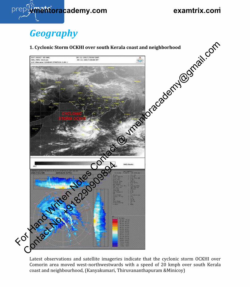
1. Cyclonic Storm OCKHI over south Kerala coast and neighborhood
Latest observations and satellite imageries indicate that the cyclonic storm OCKHI over
Comorin area moved west-northwestwards with a speed of 20 kmph over south Kerala
coast and neighbourhood, (Kanyakumari, Thiruvananthapuram &Minicoy)
For Han
d Writt
en N
otes C
ontac
t @ vm
entor
acad
emy@
gmail
.com
Contac
t No:
+918
2909
0989
4
vmentoracademy.com examtrix.com

For updates on WhatsApp, share your name & city on WhatsApp No. 75978-30000
2
Website: www.prepmate.in Telegram Channel: @upscprepmate
Prepmate Cengage Books Preview: https://prepmate.in/books/ Youtube channel: PrepMate Edutech
The system is very likely to move west-northwestwards towards Lakshadweep Islands and
intensify further into a severe cyclonic storm.
About Ockhi:
The name Ockhi was given by Bangladesh which in Bengali means eye .
What are tropical cyclones?
A tropical cyclone is a rapidly rotating storm system characterized by a low-pressure
center, a closed low-level atmospheric circulation, strong winds, and a spiral arrangement
of thunderstorms that produce heavy rain.
How tropical cyclones are named?
The World Meteorological Organisation (WMO) and the United Nations Economic and
Social Commission for Asia and the Pacific (ESCAP) started the tropical cyclone naming
system in 2000. Tropical cyclones are named to provide ease of communication between
forecasters and the general public regarding forecasts, watches, and warnings.
64 names. One name from each country is picked in an order to name the cyclones.
The previous storm Mora that caused severe —flooding across Northeast India in May was
named by Thailand. Mora is the name of one of the healing stones and also means star of
the sea. The next cyclone will be named Sagar a name given by India.
(Adapted from PIB)
2. All about Mount Agung volcano eruption in Bali, Indonesia
What happened?
The eruption of Mount Agung volcano at Bali in Indonesia forced authorities to close the
airport for a few days on November 28, 2017, stranding thousands of travellers.
According to sources, NASA monitoring satellite had indicated a significant amount of
magma near the surface. Climate scientists are studying the eruption for clues to a possible
short-cut to curb global warming by injecting sun-dimming chemicals high above the earth.
About Mount Agung:
Mount Agung or Gunung Agung is a active volcano in Bali. This strato volcano is the highest
point on the island. It dominates the surrounding area influencing the climate. The clouds
come from the west and Agung takes their water so that the west is lush and green and the
east dry and barren.
What was its impact when it (Agung Volcano) last erupted?
For Han
d Writt
en N
otes C
ontac
t @ vm
entor
acad
emy@
gmail
.com
Contac
t No:
+918
2909
0989
4
vmentoracademy.com examtrix.com

For updates on WhatsApp, share your name & city on WhatsApp No. 75978-30000
3
Website: www.prepmate.in Telegram Channel: @upscprepmate
Prepmate Cengage Books Preview: https://prepmate.in/books/ Youtube channel: PrepMate Edutech
When the Agung volcano had last erupted in 1963, it had spewed an estimated 8 million
tonnes of sulphur dioxide into the stratosphere, enough to trim world temperatures for
months.
What is the impact in recent occurring?
Smoke and lava spouting from Agung, is estimated to be about 10,000 tonnes of sulphur
dioxide, and not reaching as high as the stratosphere; villagers watching a river
overflowing with water mixed with volcanic ash and students heading to school.
What is a volcano?
A volcano is a rupture in the crust of a planetary-mass object, such as Earth, that allows hot
lava, volcanic ash, and gases to escape from a magma chamber below the surface.
What is Strato volcano?
Stratovolcanoes or composite volcanoes are tall conical mountains composed of lava flows
and other ejecta in alternate layers, the stratathat gives rise to the name. Stratovolcanoes
are also known as composite volcanoes because they are created from multiple structures
during different kinds of eruptions. Strato/composite volcanoes are made of cinders, ash,
and lava. Cinders and ash pile on top of each other, lava flows on top of the ash, where it
cools and hardens, and then the process repeats. Classic examples include Mount Fuji in
Japan, Mayon Volcano in the Philippines, and Mount Vesuvius and Stromboli in Italy.
Why did it occur?
Earth's volcanoes occur because its crust is broken into 17 major, rigid tectonic plates that
float on a hotter, softer layer in its mantle. Therefore, on Earth, volcanoes are generally
found where tectonic plates are diverging or converging, and most are found underwater.
For example, a mid-oceanic ridge, such as the Mid-Atlantic Ridge, has volcanoes caused by
divergent tectonic plates whereas the Pacific Ring of Fire has volcanoes caused by
convergent tectonic plates.
What are the possible impacts of Volcano eruptions?
1. Erupting volcanoes can pose many hazards, not only in the immediate vicinity of the
eruption. One such hazard is that volcanic ash can be a threat to aircraft, in particular those
with jet engines where ash particles can be melted by the high operating temperature; the
melted particles then adhere to the turbine blades and alter their shape, disrupting the
operation of the turbine.
2. Large eruptions can affect temperature as ash and droplets of sulfuric acid obscure the
sun and cool the Earth's lower atmosphere (or troposphere); however, they also absorb
heat radiated from the Earth, thereby warming the upper atmosphere (or stratosphere).
(Adapted from The Hindu)
3. A Concise study/guide about the unusual storm (Ockhi)
For Han
d Writt
en N
otes C
ontac
t @ vm
entor
acad
emy@
gmail
.com
Contac
t No:
+918
2909
0989
4
vmentoracademy.com examtrix.com
For updates on WhatsApp, share your name & city on WhatsApp No. 75978-30000
4
Website: www.prepmate.in Telegram Channel: @upscprepmate
Prepmate Cengage Books Preview: https://prepmate.in/books/ Youtube channel: PrepMate Edutech
About Ockhi:
Ockhi is an active tropical cyclone currently threatening and impacting India, and is the
most intense to traverse the Arabian Sea since Cyclone Megh in 2015. The name Ockhi was
given by Bangladesh which in Bengali means eye .
So, what is special about Ockhi?
Mostly, the area in which it developed. Cyclones are known to originate in both the Bay of
Bengal and the Arabian Sea sides of the northern Indian Ocean; there is much— more
frequency on the Bay of Bengal side though, especially of the stronger cyclones in fact, the
Bay of Bengal side witnesses four times more cyclones than the Arabian Sea side on
average.
But Ockhi originated near the south-western coast of Sri Lanka, and travelled very near the
southern-most tip of the Indian mainland, along the coasts of Tamil Nadu and Kerala,
towards the Lakshadweep islands, where it was at its most powerful. It weakened
considerably after that and continued— further, taking a north-easterly turn towards the
Maharashtra and Gujarat coastlines cyclones in this area are not a common phenomenon.
Why does the Bay of Bengal have more cyclones than the Arabian Sea?
Meteorologists say the relatively colder waters of the Arabian Sea are not conducive to the
formation and intensification of cyclones. Additionally, the eastern coast of India receives
cyclones that form not just in the Bay of Bengal, mostly around the Andaman Sea near the
Andaman and Nicobar Islands, but also those travelling from the Pacific Ocean, where the
frequency of typhoons , as these are called there, is quite high.
Most of these cyclones weaken considerably after encountering a big landmass. Therefore,
these do not travel to the Arabian Sea side. The western coast of India thus witnesses only
those cyclones that originate locally or the ones, like Ockhi, that travel from the Indian
Ocean near Sri Lanka.
How powerful was Ockhi?
Ockhi was described as a very severe cyclonic storm , the third strongest category
according to the definitions used by the India Meteorological Department (IMD).
Cyclones are categorised by the maximum wind speed they generate.
At its most powerful, Ockhi had wind speeds between 155 and 165 km per hour, touching
the upper border for very severe cyclonic storm . Cyclones with wind speeds between 165
and 220 km per hour are classified as extremely severe cyclonic storm .
Those with even higher wind speeds are called super-cyclones . The most famous instance
of a super-cyclone was the one that hit the coast of Odisha in October 1999. It was the
For Han
d Writt
en N
otes C
ontac
t @ vm
entor
acad
emy@
gmail
.com
Contac
t No:
+918
2909
0989
4
vmentoracademy.com examtrix.com

For updates on WhatsApp, share your name & city on WhatsApp No. 75978-30000
5
Website: www.prepmate.in Telegram Channel: @upscprepmate
Prepmate Cengage Books Preview: https://prepmate.in/books/ Youtube channel: PrepMate Edutech
strongest-ever cyclone recorded in that area, with wind speeds touching 260 km per hour.
It was also the most devastating cyclone to have hit India.
The 2013 Phailin cyclone very nearly got categorised as a super-cyclone. It had maximum
wind speeds of around 220 km per hour.
Cyclone forecasts by the IMD in the recent past have been made five to six days in advance,
thereby minimizing the damage caused. Was the IMD late in issuing a warning for Ockhi?
How early the forecast is depends on how far we are from the place where the cyclone is
emerging. Many of the big cyclones in recent years, like Phailin in 2013, Hudhud in 2014 or
Vardah in 2016, developed near the Andaman Sea. From there, it took those cyclones about
five to six days to hit the Andhra Pradesh or Odisha coasts.
These forecasts can be made only after an emerging depression is detected to have the
properties of a cyclonic storm. This was true in the case of Ockhi as well.
But the origin of Ockhi was much closer home. The cyclone formation was detected during
the morning of Wednesday, November 29. An alert was issued around noon. But many
areas in Tamil Nadu and on the Kerala coast started feeling the impact from Thursday itself.
A day later, the Lakshadweep islands bore the brunt of the cyclone. Because it developed
nearby, the lead time for the forecast was much less than in other recent cyclone cases.
(Adapted from The Indian Express)
4. Re-curving of cyclones
What is it?
First, it helps to get a sense of how cyclones move. The ones that typically strike the Indian
neighbourhood in the northern hemisphere rotate anticlockwise. Their normal behaviour
is to derive strength from the moisture in waters such as the Bay of Bengal, move west,
incline in a northerly direction and peter out into the sea or land, depending on their origin.
This is how you would explain a regular cyclone, say like Mora, which formed over the Bay
of Bengal on May 26. It rapidly strengthened on May 28. It kept north, almost parallel to the
Myanmar coast and then made landfall in Bangladesh and blew over Nagaland. In a re-
curving cyclone, the cyclone gets a sort of second wind when it is on the wane.
Like the googly in cricket, it s deflected right or eastwards. This is due to air currents in the
local atmosphere that push cold air from the poles towards the equator and interfere with
cyclone formation. That s what make them re-curving. In the southern hemisphere, the
cyclones spin clockwise and therefore also re-curve in the opposite direction.
For Han
d Writt
en N
otes C
ontac
t @ vm
entor
acad
emy@
gmail
.com
Contac
t No:
+918
2909
0989
4
vmentoracademy.com examtrix.com

For updates on WhatsApp, share your name & city on WhatsApp No. 75978-30000
6
Website: www.prepmate.in Telegram Channel: @upscprepmate
Prepmate Cengage Books Preview: https://prepmate.in/books/ Youtube channel: PrepMate Edutech
How do they come about?
During the monsoon months, cyclones in the Western Pacific move westwards towards
India and aid the associated rain-bearing systems over the country. However, in the years
of a re-curve, they do not give as much of a push to the rain as they do in the good monsoon
years and that is why monsoon rain this August was a dampener. Rain that month was 13%
short of what is usual and meteorologists say it was almost certainly because of an active
hurricane season in the Pacific that consisted of a few re-curving cyclones. However, these
are back in the news due to Cyclone Ockhi. The whirlwind that arose in the Bay of Bengal
and revved up over Sri Lanka was expected to pass over Lakshadweep and then ease into
the Arabian Sea, far away from India s west coast.
However, the cyclone ended up sharply swerving into parts of Maharashtra and Gujarat. It
did not blow in very strongly because there it had not gained as much moisture from the
Arabian Sea like it had over the Bay of Bengal and the Indian Ocean boundary. And though
it wreaked havoc in Kerala and Tamil Nadu, even a weakened Ockhi destroyed several
beaches in Goa when it curved back to the land.
Why does it matter?
Long-term data suggest that while there has been an increase in the number of tropical
cyclones in India s neighbourhood there is no clear trend in re-curving ones. In general,
cyclone activity in India peaks around November, by which time, the summer monsoon has
already passed. Rarely do re-curving cyclones pose a mortal threat to Indian coasts and
Cyclone Ockhi raised hackles because it had already left a certain amount of damage and
threatened Gujarat and Maharashtra. It was also among the rare curving cyclones with a
presence over the Arabian Sea.
What lies ahead?
As climate change is projected to increase the frequency of extreme events, scientists have
warned that tropical cyclones are likely to get more intense, and this could mean more
scrutiny of re-curving ones. A challenge— with re-curving cyclones is—that it is hard for
weather models to pick them early on as was the case with Ockhi and so they pose unique
challenges in terms of hazard preparedness and disaster management.
(Adapted from The Hindu)
5. All you need to know about urban heat island effect
For Han
d Writt
en N
otes C
ontac
t @ vm
entor
acad
emy@
gmail
.com
Contac
t No:
+918
2909
0989
4
vmentoracademy.com examtrix.com

For updates on WhatsApp, share your name & city on WhatsApp No. 75978-30000
7
Website: www.prepmate.in Telegram Channel: @upscprepmate
Prepmate Cengage Books Preview: https://prepmate.in/books/ Youtube channel: PrepMate Edutech
What is an Urban Heat Island?
An urban heat island (UHI) is an urban area or metropolitan area that is significantly
warmer than its surrounding rural areas due to human activities. This effect is known as
Urban Heat Island effect. UHI is different from a Heat Island (HI), which may even include
an unpopulated area.
What are the reasons for the formation of UHIs?
1. Heavy vehicular and industrial pollution in urban areas.
2. Discharge of greenhouse gases (GHGs) in substantial amounts, which trap the outgoing
infrared radiations.
3. Tall buildings and other infrastructure which obstruct the flow of wind, consequently
obstructing the transfer of heat.
4. Lack of vegetation which can act as both heat and carbon sink.
5. Majority of urban surfaces are composed of metal, glass, concrete or asphalt. These
materials have high heat retaining capacity during the day and emit this heat out during the
night.
6. The inability of water to penetrate the above materials, makes the urban landscape
behave as a desert landscape.
Effects of UHIs:
For Han
d Writt
en N
otes C
ontac
t @ vm
entor
acad
emy@
gmail
.com
Contac
t No:
+918
2909
0989
4
vmentoracademy.com examtrix.com

For updates on WhatsApp, share your name & city on WhatsApp No. 75978-30000
8
Website: www.prepmate.in Telegram Channel: @upscprepmate
Prepmate Cengage Books Preview: https://prepmate.in/books/ Youtube channel: PrepMate Edutech
1. UHIs have the potential to directly affect the health of urban residents. UHIs witness
prolonged heat waves which result in higher fatalities due to heat stroke, exhaustion, heat
cramps, etc.
2. UHIs have varied effects on biodiversity. The variations in temperatures adversely affect
local species but may promote the invasion of alien species. The raised temperature may
elevate the temperature of local water bodies causing the marine animals to undergo
thermal stress and shock.
The increased temperatures provide fertile breeding ground for insects, which bring a host
of diseases along with them.
3. UHIs create a spike in energy consumption due to constant use of refrigerators and air
conditioners.
4. UHIs can alter local weather conditions like wind, humidity, rainfall, etc.
Mitigation Strategies
1. The effects of UHIs can be diluted to some extent by employing techniques to maintain a
large albedo. Larger the albedo of an object, more is its power to reflect radiations. The
buildings and other dark surfaces (asphalt) could be painted with a light colour or with a
high reflectivity coating.
2. Green roofs (roofs with plants and vegetation) on top of buildings help lower down the
temperatures and compensate to some extent, for the loss of vegetation. Besides green
roof, Roof sprinkling is another evaporative cooling technique.
3. Increasing area under natural vegetation and reclaiming waste lands to develop green
belts may also help moderate the effects of UHIs.
4. Green parking lots, which use vegetation and materials other than asphalt.
Study conducted on the urban heat island effect:
To explain how this happens, a team of researchers studied the warming of Bhubaneswar, a
tier-2 city, due to rapid urbanization compared to non-urban areas that surround it.
Findings of the study:
Rapid urbanization combined with changes in land use pattern between 2000 and 2014 led
to about 1.8°C warming of Bhubaneswar compared with surrounding non-urban areas
(called the urban heat island effect), the researchers say.
The team found that increase in urbanization has been rapid at 83% in the last 15 years.
This has led to about 89% decrease in dense vegetation, about 2% decrease in water bodies
For Han
d Writt
en N
otes C
ontac
t @ vm
entor
acad
emy@
gmail
.com
Contac
t No:
+918
2909
0989
4
vmentoracademy.com examtrix.com

For updates on WhatsApp, share your name & city on WhatsApp No. 75978-30000
9
Website: www.prepmate.in Telegram Channel: @upscprepmate
Prepmate Cengage Books Preview: https://prepmate.in/books/ Youtube channel: PrepMate Edutech
and nearly 83% decrease in crop fields during the same period. Decrease in crop areas
could either be due to urbanization or fields remaining fallow.
These changes have led to increase in the urban heat island effect. The central part of the
city has not witnessed much change in land cover, while the adjoining areas have witnessed
major changes due to expansion of the city, leading to the warming of the city.
Past picture of the city:
Bhubaneswar was once well covered by three forests. The 1999 Odisha super cyclone
destroyed many trees, and many trees have been cut for road expansion. Today, only a very
small percentage of forest cover is remaining.
Conclusion:
All the losses mentioned negatively impact the thermal and radiative properties of the
surface and make cities hotter than surrounding non-urban areas. With heavily built-up
areas and concrete structures, most cities in India and in the world are warmer than
surrounding non-urban areas due to the urban heat island effect. For instance, Delhi is 4-
12°C warmer due to the urban heat island effect.
(Adapted from The Hindu and Background from Environment & Diversity book
PrepMate-Cengage Series)
6. Analysis of the cyclone Ockhi
In which regions did the Ockhi hit?
The cyclonic storm struck the southern tip of the subcontinent and Lakshadweep, to which
Kerala is still coming to terms with the destruction left behind by it.
What was the incapacity observed during the hit?
The State government initially struggled to deal with the human tragedy as hundreds of
fishermen from five coastal villages in Thiruvananthapuram were reported missing at sea.
The death toll so far is 65. The storm, the likes of which the southwest coast of India has not
seen for decades, exposed the chinks in Kerala s disaster preparedness.
Political discrepancy:
1. Almost a month after the storm, there has been no let-up in the blame game between the
India Meteorology Department (IMD) and the State Disaster Management Authority
(SDMA) about why people were not told of the impending danger.
While the State government and the SDMA assert that the IMD failed to issue a cyclone alert
on time, thus jeopardising the lives of hundreds of fishermen, the Central agency maintains
that the State ignored its warning of a deep depression that was threatening to intensify
into a cyclone.
For Han
d Writt
en N
otes C
ontac
t @ vm
entor
acad
emy@
gmail
.com
Contac
t No:
+918
2909
0989
4
vmentoracademy.com examtrix.com

For updates on WhatsApp, share your name & city on WhatsApp No. 75978-30000
10
Website: www.prepmate.in Telegram Channel: @upscprepmate
Prepmate Cengage Books Preview: https://prepmate.in/books/ Youtube channel: PrepMate Edutech
2.There is also a raging dispute over the number of missing fishermen, between the
Fisheries and Revenue Departments on the one hand.
About IMD:
The India Meteorological Department (IMD), also referred to as the Met Department, is an
agency of the Ministry of Earth Sciences of the Government of India.
It is the principal agency responsible for meteorological observations, weather forecasting
and seismology. IMD is headquartered in Delhi and operates hundreds of observation
stations across India and Antarctica.
IMD is also one of the six Regional Specialised Meteorological Centres of the World
Meteorological Organization. It has the responsibility for forecasting, naming and
distribution of warnings for tropical cyclones in the Northern Indian Ocean region,
including the Malacca Straits, the Bay of Bengal, the Arabian Sea and the Persian Gulf.
About SDMA (State Disaster Management Authority):
All State Governments are mandated under Section 14 of the act to establish a State
Disaster Management Authority (SDMA). The SDMA consists of the Chief Minister of the
State, who is the Chairperson, and no more than eight members appointed by the Chief
Minister.
State Executive Committee is responsible (Section 22) for drawing up the state disaster
management plan, and implementing the National Plan.
The SDMA is mandated under section 28 to ensure that all the departments of the State
prepare disaster management plans as prescribed by the National and State Authorities
Account of loss in terms of lives lost in it:
Search teams have recovered 65 bodies offshore and 80 fishermen are still missing at sea.
Over 150 traumatised families are still struggling to come to terms with the loss of their
breadwinners.
What are the steps taken to deal with such situations in future?
1. A major revamp of the SDMA is on the cards, with more experts expected to be brought
on board.
2. The government has also initiated efforts to deploy satellite communication facilities for
the safety of fishers at sea.
Consequential effect of the incompetence projected by the administration:
The coastal communities are not willing to settle for anything short of exemplary
punishment for those guilty of lapses in alerting them to the cyclone.
For Han
d Writt
en N
otes C
ontac
t @ vm
entor
acad
emy@
gmail
.com
Contac
t No:
+918
2909
0989
4
vmentoracademy.com examtrix.com

For updates on WhatsApp, share your name & city on WhatsApp No. 75978-30000
11
Website: www.prepmate.in Telegram Channel: @upscprepmate
Prepmate Cengage Books Preview: https://prepmate.in/books/ Youtube channel: PrepMate Edutech
They harbour a deep mistrust in the government s capacity to spend the relief funds
without diversion or wastage.
What teachings did Ockhi bring along with it?
Cyclone Ockhi has underlined the need for meteorologists to come up with better
forecasting systems, especially in light of projections about the increasing frequency and
intensity of extreme weather events along the western coast due to the warming of the
Arabian Sea.
It forced to re-assess the vulnerabilities and develop appropriate mitigation strategies in
view of the challenges posed by climate change.
Experts Viewpoint:
The experts point out that the best prediction model is useless unless the government
deploys an efficient dissemination system to warn vulnerable communities in time.
(Adapted from The Hindu)
7. Jakarta sinking fast? Here is why the Indonesian capital will soon be under water
Present condition of Jakarta
The Java sea that was at a good distance from human habitats in the city of Jakarta has
slowly crept closer. And it will not be long before the Indonesian capital goes underwater!
The city of Jakarta is sinking and that too at a fast pace.
According to a report by the New York Times, the city of Jakarta is sinking faster than any
other big city on the planet. All this is happening so surreally fast that rivers sometimes
flow upstream, even ordinary rains regularly swamp neighbourhoods and the buildings are
slowly disappear underground as if they are being swallowed by the earth.
For Han
d Writt
en N
otes C
ontac
t @ vm
entor
acad
emy@
gmail
.com
Contac
t No:
+918
2909
0989
4
vmentoracademy.com examtrix.com
For updates on WhatsApp, share your name & city on WhatsApp No. 75978-30000
12
Website: www.prepmate.in Telegram Channel: @upscprepmate
Prepmate Cengage Books Preview: https://prepmate.in/books/ Youtube channel: PrepMate Edutech
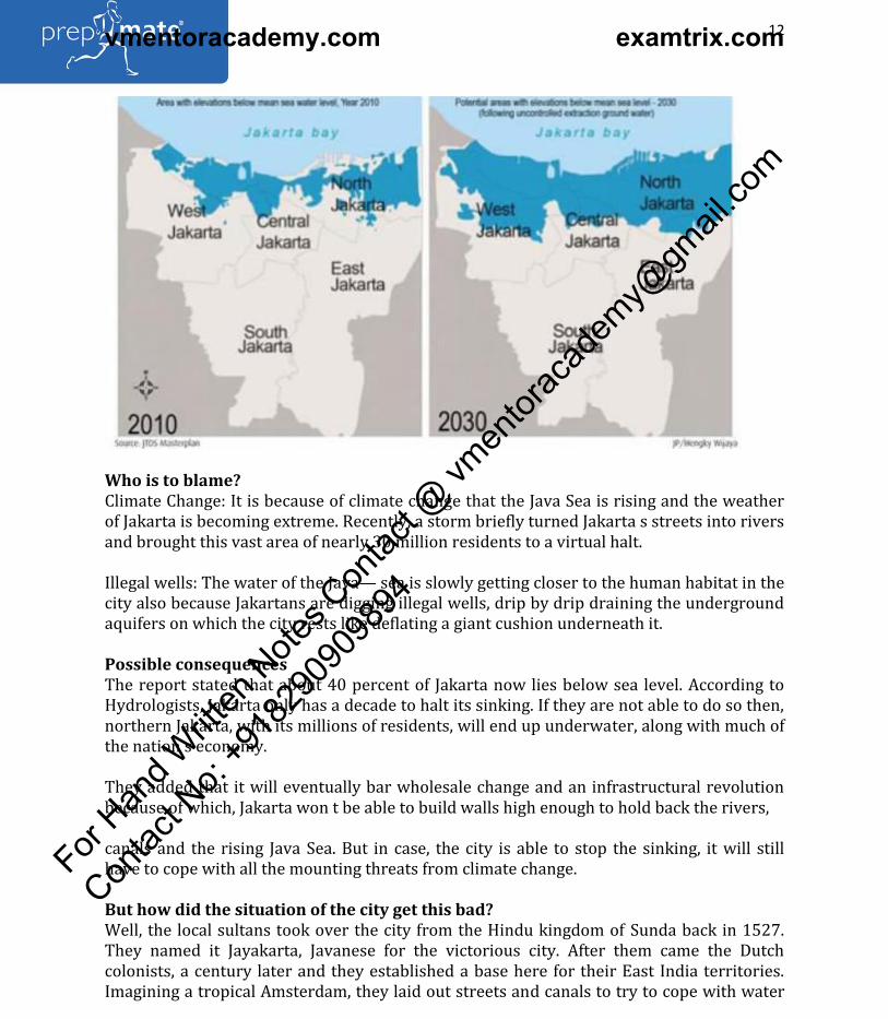
Who is to blame?
Climate Change: It is because of climate change that the Java Sea is rising and the weather
of Jakarta is becoming extreme. Recently, a storm briefly turned Jakarta s streets into rivers
and brought this vast area of nearly 30 million residents to a virtual halt.
Illegal wells: The water of the Java— sea is slowly getting closer to the human habitat in the
city also because Jakartans are digging illegal wells, drip by drip draining the underground
aquifers on which the city rests like deflating a giant cushion underneath it.
Possible consequences
The report stated that about 40 percent of Jakarta now lies below sea level. According to
Hydrologists, Jakarta only has a decade to halt its sinking. If they are not able to do so then,
northern Jakarta, with its millions of residents, will end up underwater, along with much of
the nation s economy.
They added that it will eventually bar wholesale change and an infrastructural revolution
because of which, Jakarta won t be able to build walls high enough to hold back the rivers,
canals and the rising Java Sea. But in case, the city is able to stop the sinking, it will still
have to cope with all the mounting threats from climate change.
But how did the situation of the city get this bad?
Well, the local sultans took over the city from the Hindu kingdom of Sunda back in 1527.
They named it Jayakarta, Javanese for the victorious city. After them came the Dutch
colonists, a century later and they established a base here for their East India territories.
Imagining a tropical Amsterdam, they laid out streets and canals to try to cope with water
For Han
d Writt
en N
otes C
ontac
t @ vm
entor
acad
emy@
gmail
.com
Contac
t No:
+918
2909
0989
4
vmentoracademy.com examtrix.com
For updates on WhatsApp, share your name & city on WhatsApp No. 75978-30000
13
Website: www.prepmate.in Telegram Channel: @upscprepmate
Prepmate Cengage Books Preview: https://prepmate.in/books/ Youtube channel: PrepMate Edutech
pouring in from the south, out of the forests and mountains, where rain falls nearly 300
days out of the year. Thirteen rivers feed into the city. After independence in 1945, the city
began to sprawl. Today, it is virtually impossible to walk around freely.
The most urgent problems are in North Jakarta. Some of the world s most polluted canals
and rivers weave a spider s web through the area. It is where the city is sinking fastest. It is
because of the decades of reckless growth and negligent leadership that happened in the
past that is causing mayhem.
(Adapted from Financial Express)
8. 2017 Was One of the Hottest Years on Record
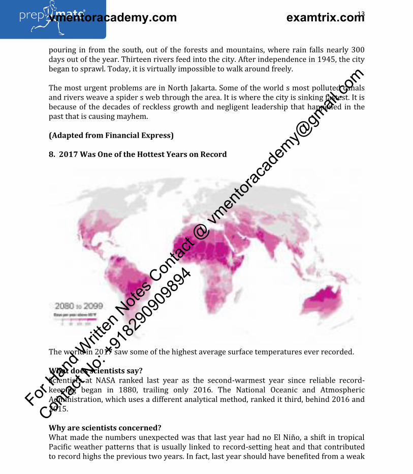
The world in 2017 saw some of the highest average surface temperatures ever recorded.
What does scientists say?
Scientists at NASA ranked last year as the second-warmest year since reliable record-
keeping began in 1880, trailing only 2016. The National Oceanic and Atmospheric
Administration, which uses a different analytical method, ranked it third, behind 2016 and
2015.
Why are scientists concerned?
What made the numbers unexpected was that last year had no El Niño, a shift in tropical
Pacific weather patterns that is usually linked to record-setting heat and that contributed
to record highs the previous two years. In fact, last year should have benefited from a weak
For Han
d Writt
en N
otes C
ontac
t @ vm
entor
acad
emy@
gmail
.com
Contac
t No:
+918
2909
0989
4
vmentoracademy.com examtrix.com

For updates on WhatsApp, share your name & city on WhatsApp No. 75978-30000
14
Website: www.prepmate.in Telegram Channel: @upscprepmate
Prepmate Cengage Books Preview: https://prepmate.in/books/ Youtube channel: PrepMate Edutech
version of the opposite phenomenon, La Niña, which is generally associated with lower
atmospheric temperatures.
What is the long – term trend?
By both the NASA and NOAA analyses, 17 of the 18 warmest years since modern record-
keeping began have occurred since 2001. Overall, fueled by emissions of carbon dioxide
and other greenhouse gases, temperatures have increased more than 1 degree Celsius (1.8
degrees Fahrenheit) since the late 19th century.
In order to avoid the worst consequences of climate change, scientists say global
temperatures must not increase more than 2 degrees Celsius.
The recent US response to climate change
The warming trend comes at a time that President Donald Trump is dialing back many
climate-related regulations and policies. Last year he announced that the United States
would withdraw from the 2015 Paris climate accord and repeal the Clean Power Plan, an
Obama-era measure designed to reduce emissions from power plants.
Details of climate change related evidence
Temperatures in the Arctic, which is warming about twice as fast as other parts of the
planet, soared again during parts of 2017, and the region continued to lose sea ice and
permafrost.
Scientists found the fingerprints of warming in many other weather events as well,
including a June heat wave that led to wildfires in southern Europe and extreme heat in
Australia s summer.
In other cases the links to climate change were not as conclusive, but a series of
catastrophes last year – including widespread hurricane damage from Texas to the
Caribbean and lethal wildfires in California – seemed to indicate that such disasters were
becoming much more common.
Researchers had expected that 2017 would end a string of three consecutive years with
record temperatures. That string was exacerbated by a strong El Niño that began in 2015
ended in the second half of 2016. (Though 2015 was not technically an El Niño year.)
Why El Nino Years are warm?
Normally, trade winds around the tropical Pacific blow from east to west, moving warmer
water away from the South American coast and piling it up around Asia and Australia. In an
El Niño those trade winds weaken or even reverse, allowing the typically colder parts of the
ocean to warm. This extra heat at the ocean s surface releases energy into the atmosphere,
increasing global temperatures.
This is why, ordinarily, El Niño years tend to be the warmest years on record.
For Han
d Writt
en N
otes C
ontac
t @ vm
entor
acad
emy@
gmail
.com
Contac
t No:
+918
2909
0989
4
vmentoracademy.com examtrix.com

For updates on WhatsApp, share your name & city on WhatsApp No. 75978-30000
15
Website: www.prepmate.in Telegram Channel: @upscprepmate
Prepmate Cengage Books Preview: https://prepmate.in/books/ Youtube channel: PrepMate Edutech
In a La Niña year, the oceanic pendulum tends to swing the other way, with the east-to-
west trade winds becoming unusually strong, strengthening the process by which cold
waters emerge from the ocean. That leads to cooler than normal ocean temperatures and,
as a result, cooler atmospheric temperatures.
The world is now experiencing a weak La Niña in year 2017.
(Adapted from New York Times and PrepMate-Cengage Geography Book, Chapter 4
Atmosphere)
9. Total Eclipse of Moon to take place on January 31
A total eclipse of the moon will occur on January 31, 2018. This is the first eclipse of the
year, with a rare coincidence of a blue moon and a super full moon.
The full moon on that day happens to be the second full moon of the calendar month of
January, termed as a blue moon. Further, the moon will be at perigee on January 30, as
such the full moon will occur when the moon is near the closest to earth in its orbit. Hence,
this full moon will be a little bigger and brighter than the regular full moon, popularly
referred to as a super moon.
For Han
d Writt
en N
otes C
ontac
t @ vm
entor
acad
emy@
gmail
.com
Contac
t No:
+918
2909
0989
4
vmentoracademy.com examtrix.com

For updates on WhatsApp, share your name & city on WhatsApp No. 75978-30000
16
Website: www.prepmate.in Telegram Channel: @upscprepmate
Prepmate Cengage Books Preview: https://prepmate.in/books/ Youtube channel: PrepMate Edutech
The eclipse will be visible in the region covering North America except the eastern part,
western South America, Asia including India, Australia, the Middle East, northern
Scandinavia, eastern Europe and eastern Africa.
The next eclipse of the Moon will occur on July 27-28, 2018, which will be a total lunar
eclipse and will be visible in India.
Lunar eclipse
Lunar eclipse: It occurs when the Earth is between the Sun and the Moon. As a result,
sunlight is blocked by the Earth from reaching the Moon. A lunar eclipse takes place during
the Full
Moon phase. A Full Moon is when we can see the entire lit portion of the Moon. The Full
Moon phase occurs when the Moon is on the opposite side of the Earth from the Sun, called
opposition.
(Adapted from pib and PrepMate-Cengage Geography Book, Chapter 2, Page 22)
10. How storms and lightning in North India killed over a hundred in just a day
Big duststorms and lightning are not unusual at this time. Why do they occur, why
did so many die?
Over 100 people were killed in duststorms, thunderstorms, and lightning at many places in
northern, central and eastern India on Wednesday. The National Disaster Management
Authority (NDMA) said lightning and thunderstorm killed 62 people in Uttar Pradesh and
32 in Rajasthan; the UP government issued a districtwise break-up of deaths that added up
to 70.
Expected, unexpected
These casualty figures seem abnormally high for weather events on a single day. However,
there was nothing unusual in the occurrence of the weather events themselves.
Rainstorms, duststorms, and even tornadoes are expected at this time of the year, and the
Meteorological Department routinely issues alerts and warnings. The weather events of
Wednesday, too, had been predicted, and warnings were issued.
How the storms built up
Rainstorms and dust storms arise from similar meteorological conditions. They are almost
always preceded — and caused — by a spell of intense heat. Thunderstorms or hail occur
when the atmosphere has moisture; when it doesn t, dust storms take place.
Many parts of India witness a build-up of surface heat during this time of the year. The
places that were hit by the storms had seen heat-wave like conditions last week.
For Han
d Writt
en N
otes C
ontac
t @ vm
entor
acad
emy@
gmail
.com
Contac
t No:
+918
2909
0989
4
vmentoracademy.com examtrix.com

For updates on WhatsApp, share your name & city on WhatsApp No. 75978-30000
17
Website: www.prepmate.in Telegram Channel: @upscprepmate
Prepmate Cengage Books Preview: https://prepmate.in/books/ Youtube channel: PrepMate Edutech
Dr Mrutunjay Mohapatra of India Meteorological Department said such events take place
due to a local instability arising out of a deviation from the normal temperature
difference between the upper and lower atmosphere. In this case, for example, moist
easterly winds from the Bay of Bengal reached up to Himachal Pradesh, which was also
receiving dry winds from the north-westerly direction. The two systems destabilized the
equilibrium temperature difference between the upper and lower layers of atmosphere,
leading to conducive conditions for a thunderstorm.
The final trigger, however, is the development of a largescale air-circulation system. In this
particular case, the trigger came from the circulation system that developed over Rajasthan
a couple of days ago.
Why so many deaths, then?
It does seem odd. However, a large number of deaths over a few days have been reported
earlier. In June 2016, more than 300 people were reported killed by lightning over three
days. Lightning is the biggest killer in India among natural calamities. In 2014 and 2015, it
killed 2,582 and 2,641, show National Crime Records Bureau data.
What was unusual about Wednesday s events was that they occurred over a large
geographical area within a very short time. Dr Sunil Pawar of the Indian Institute of
Tropical Meteorology, Pune, explained that severe thunderstorm clouds can sometimes
arrange themselves within a few hours in long squall lines of 150-250 km length.
What use the predictions?
In most cases, storms do not kill by themselves. Even lightning rarely strikes people
directly. But they trigger incidents that result in deaths. Walls or homes collapse, and
people are electrocuted after power lines snap, or after they are caught in fields filled with
water. People in the poorest, most densely populated areas are the most vulnerable.
Also, meteorological predictions are for broad geographical areas and timeframes. The
events themselves are, however, very localised, both in time and space. It is not yet possible
to predict a thunderstorm or lightning at a precise location — say a village or a part of a
city.
The exact times these events will hit, too, cannot be predicted. Alerts and warnings are in
the nature of a general advisory, telling the people to expect these events, and to take
precautions.
(Adapted from The Indian Express)
11. NWIC setup as a single window source of updated data on water resources
National Water Informatics Centre (NWIC)
For Han
d Writt
en N
otes C
ontac
t @ vm
entor
acad
emy@
gmail
.com
Contac
t No:
+918
2909
0989
4
vmentoracademy.com examtrix.com

For updates on WhatsApp, share your name & city on WhatsApp No. 75978-30000
18
Website: www.prepmate.in Telegram Channel: @upscprepmate
Prepmate Cengage Books Preview: https://prepmate.in/books/ Youtube channel: PrepMate Edutech
Consequent upon approval of the Cabinet, National Water Informatics Centre (NWIC) has
recently been created by Ministry of Water Resources, River Development and Ganga
Rejuvenation at New Delhi vide notification dated 28th March 2018. NWIC would be a
repository of nation-wide water resources data and would work as a Subordinate Office
under the Ministry of Water Resources, River Development and Ganga Rejuvenation. The
centre would be headed by a Joint Secretary level officer.
Need for NWIC
The management of water resources is a highly complex and tedious task that involves
expertise of multidisciplinary domains and depend on historical and real time reliable data
and information. For this, the first requirement is to develop, maintain and update
regularly a comprehensive Water Resources Information System (WRIS) in public
domain for awareness and involvement of all concerned for effective integrated water
resources management. This is also prerequisite for scientific assessment, monitoring,
modelling and Decision Support System (DSS) and Integrated water resource Management.
In this back drop NWIC is expected to provide a Single Window source of updated data on
water resources & allied themes; and provides value added products and services to all
stake holders for its management and sustainable development.
To empower, inform and enrich every citizen with upto date and reliable water data (other
than classified data) and information through web-based India Water Resources
Information System (India-WRIS) on a GIS platform in Public Domain; and to develop value
added products and services for all aspects of integrated water resources management
serving the nation through research, capacity building, linkages, outreach and better
governance in water resources sector.
Besides the centre will also collaborate with leading research institutes nationally as well
as internationally to provide technical support to other central and state organizations
dealing with water, emergency response for hydrological extremes.
(Adapted from PIB)
12. Mumbai, where a development plan for the future is stirring debate
For Han
d Writt
en N
otes C
ontac
t @ vm
entor
acad
emy@
gmail
.com
Contac
t No:
+918
2909
0989
4
vmentoracademy.com examtrix.com
For updates on WhatsApp, share your name & city on WhatsApp No. 75978-30000
19
Website: www.prepmate.in Telegram Channel: @upscprepmate
Prepmate Cengage Books Preview: https://prepmate.in/books/ Youtube channel: PrepMate Edutech
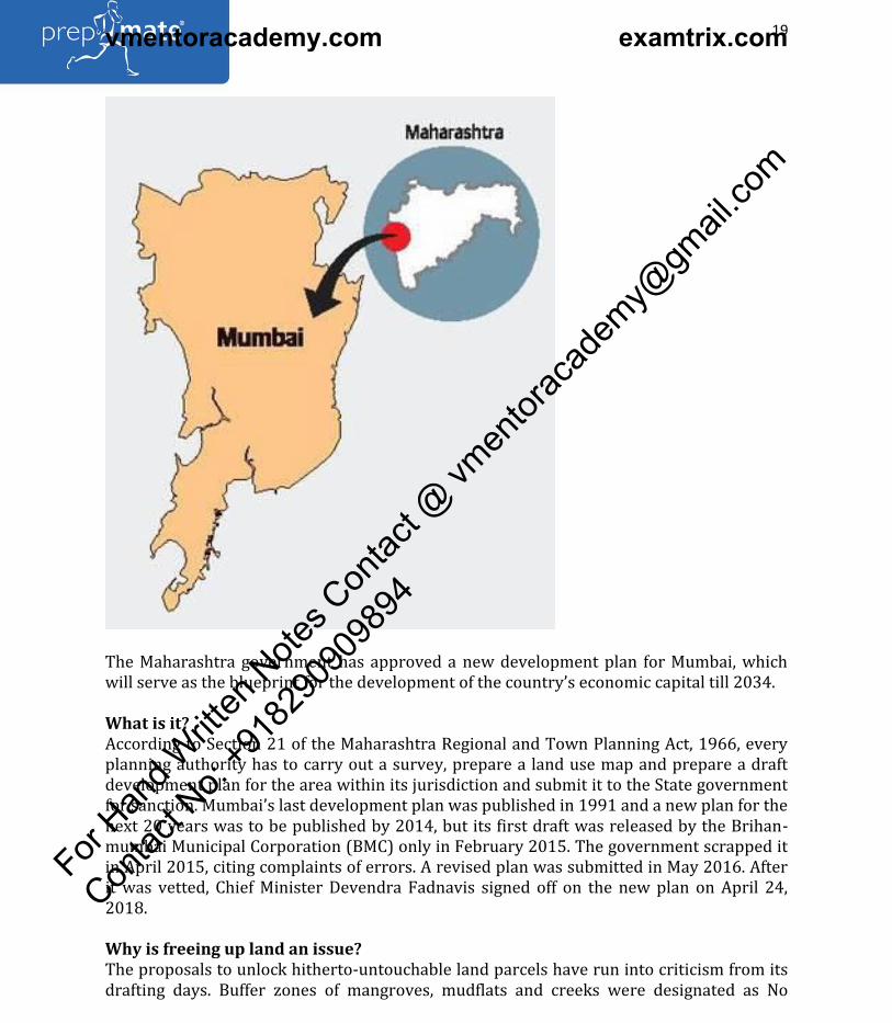
The Maharashtra government has approved a new development plan for Mumbai, which
will serve as the blueprint for the development of the country s economic capital till 2034.
What is it?
According to Section 21 of the Maharashtra Regional and Town Planning Act, 1966, every
planning authority has to carry out a survey, prepare a land use map and prepare a draft
development plan for the area within its jurisdiction and submit it to the State government
for sanction. Mumbai s last development plan was published in 1991 and a new plan for the
next 20 years was to be published by 2014, but its first draft was released by the Brihan-
mumbai Municipal Corporation (BMC) only in February 2015. The government scrapped it
in April 2015, citing complaints of errors. A revised plan was submitted in May 2016. After
it was vetted, Chief Minister Devendra Fadnavis signed off on the new plan on April 24,
2018.
Why is freeing up land an issue?
The proposals to unlock hitherto-untouchable land parcels have run into criticism from its
drafting days. Buffer zones of mangroves, mudflats and creeks were designated as No
For Han
d Writt
en N
otes C
ontac
t @ vm
entor
acad
emy@
gmail
.com
Contac
t No:
+918
2909
0989
4
vmentoracademy.com examtrix.com
For updates on WhatsApp, share your name & city on WhatsApp No. 75978-30000
20
Website: www.prepmate.in Telegram Channel: @upscprepmate
Prepmate Cengage Books Preview: https://prepmate.in/books/ Youtube channel: PrepMate Edutech
Development Zones in the 1991 plan, but the authorities have earmarked 2,100 hectares of
such land for affordable housing. The logic: these zones were not supposed to be locked
away forever. Another 330 hectares of saltpan lands will be diverted from the Mumbai Port
Trust s reserves. The Aarey Colony remains a green zone, but 300 acres has been set aside
for a Metro Rail car shed, a second zoo and the rehabilitation of tribals. Besides, 14.96 sq.
km. of virgin land (mangroves) has been included as Natural Areas, which will be left
untouched.
Is it achievable?
The BMC has set aside Rs. 2,000 crore in its annual budget for the implementation of the
plan this year. The government has hiked Floor Space Index (FSI) for Mumbai. The FSI is
the ratio of construction allowed on a plot to the size of the plot. The FSI for the island city
has been increased from 2 to 3, while that for the suburbs has been kept at 2.5. The State
has announced 15% free FSI for redevelopment of private buildings and raised the FSI for
commercial development to 5 from the existing 2.5 to spur economic activity. Citizens now
have the choice to design their houses as long as they do not disturb the structural
elements or plumbing systems.
What will be difficult?
The BMC believes the plan makes provision for 8 million jobs and 1 million affordable
homes, but experts are not sure. Land acquisition will be the biggest hurdle: the BMC will
need Rs. 14 lakh crore to implement the plan, with land costs included. Since it does not
want to shell out such huge sums, it is betting on a policy that is dependent on private
players to acquire any reserved land, clear it of encroachment, develop and hand it over to
the BMC in lieu of construction rights and incentives. But the process is known to take very
long.
Will it ease civic woes?
Despite Mumbai s huge population, the total area under housing is just about 22% and the
city s planners want to make that 50%. The area reserved per capita for open spaces,
educational institutions and offices will increase, but is still woefully short of international
norms. In order to add to the existing open spaces, a 300-acre garden will be developed on
reclaimed land at Cuffe Parade on the lines of New York s Central Park. Another such
garden will be developed by the Mumbai Port Trust at Sewree.
What s in store?
The 1991 plan saw only around 20% implementation. This time, to improve the
implementation rate, the BMC has conceived four 5-year plans with amounts to be set aside
in every budget. In fact, the plan will act as the guiding document for making budgetary
provisions and an implementation cell will be tasked with tracking progress.
(Adapted from The Hindu)
13. Zojila tunnel to bring Srinagar, Kargil and Leh closer
For Han
d Writt
en N
otes C
ontac
t @ vm
entor
acad
emy@
gmail
.com
Contac
t No:
+918
2909
0989
4
vmentoracademy.com examtrix.com

For updates on WhatsApp, share your name & city on WhatsApp No. 75978-30000
21
Website: www.prepmate.in Telegram Channel: @upscprepmate
Prepmate Cengage Books Preview: https://prepmate.in/books/ Youtube channel: PrepMate Edutech
Prime Minister launches work on Zojila tunnel project
Prime Minister Narendra Modi inaugurated the Zojila tunnel project, which will provide all-
weather connectivity to Srinagar, Kargil and Leh. At 14.15 km, it will be the country s
longest road tunnel.
The tunnel will cut down the time taken to cross the Zojila pass from the three hours 30
minutes to 15 minutes.
Asia s longest bidirectional tunnel will be built at a cost of Rs. 6,809 crore. The work is
expected to be completed in five years.
The pass is situated at an altitude of 11,578 ft on the Srinagar-Kargil-Leh National Highway
and remains closed during winter because of heavy snowfall, cutting off the Ladakh region
from Kashmir.
(Adapted from the Hindu)
14. Why have monsoons been fierce so far?
What is the status?
In the fortnight since the start of the monsoon, India has recorded nearly 55 mm of rain, or
16% more than what s usual for this time of the year. The bulk of it has been over south
and central India, with the northeastern States so far registering a 24% deficit. After an
early onset and quick advance, the monsoon has stalled and will remain so for at least a
week, say meteorologists. However, several parts of northeastern India are expected to
receive substantial rain, according to the latest weather outlook from the India
Meteorological Department (IMD). Because the southern branch of the monsoon has
stalled, it is causing heavy rain in Goa, coastal Karnataka and Kerala. The latter has seen 44
cm, nearly 49% more than what it gets in the first fortnight of June. This has led to
widespread havoc.
Has lightning activity been high?
Lightning, according to the National Crime Records Bureau (NCRB), is the leading cause of
accidental deaths in India attributable to the forces of nature. The NCRB s most updated
report, from 2015, says that of the 10,510 accidental deaths attributable to natural causes,
25.1% were due to lightning, 18.2% due to heat/sun stroke and 10.9% due to exposure to
cold. Therefore, in any given year lightning is a serious killer. This year, however, May —
which is not a monsoon month — saw nearly 300 deaths due to lightning in Uttar Pradesh,
Bihar, Jharkhand and West Bengal. Because of unusual convective activity, Andhra Pradesh
in April recorded nearly 36,000 lightning strikes in a single day. Typically that is what the
State suffers in an entire pre-monsoon month. Therefore, even pre-monsoon rain can
contribute to massive cloudbuildups and trigger widespread lightning strikes. Despite all
that lightning, no more than 10 deaths were reported.
For Han
d Writt
en N
otes C
ontac
t @ vm
entor
acad
emy@
gmail
.com
Contac
t No:
+918
2909
0989
4
vmentoracademy.com examtrix.com

For updates on WhatsApp, share your name & city on WhatsApp No. 75978-30000
22
Website: www.prepmate.in Telegram Channel: @upscprepmate
Prepmate Cengage Books Preview: https://prepmate.in/books/ Youtube channel: PrepMate Edutech
Thus, there is no one-to-one link between the strength of the monsoon in one year and
lightning deaths. Given that 2,000-2,500 deaths occurring due to lightning annually is
normal, (going by the NCRB figures that go back to 2005), and there is a delay in how
quickly lightning death records are made publicly available, it is yet early to understand if
this year has seen an unusual spike.
Can lightning forecasts be improved?
Lightning and thunderstorms are an extremely local phenomenon with impact spreading
no more than a few kilometres. Also they tend to occur rather suddenly and are therefore
beyond the range of the weather radars. It is possible for the meteorological department to
warn of the likelihood of thunderstorms and lightning over a district or a city about a day in
advance but street-level or area-wise accuracy remains a stretch. While the build-up of
clouds is known to be a factor, much more improved weather modelling is required to give
accurate warnings about an impending strike in, say, a small town or village. The best way
around this is precaution. State- and district-level disaster management agencies routinely
issue advisories asking people to refrain from using mobile phones or handling electrical
equipment plugged to sockets. That lightning strikes disproportionately affect the poor is
also a fact noted by experts. So poorly built houses, staying out in the open during
thunderstorms, being in places that aren t properly electrically insulated, and the mere fact
of working in open fields substantially increase the risk of death from lightning.
What s in store?
The IMD said in May that India would get 97% of the 89 cm it gets during the monsoon
months. Rainfall is expected to be normal in July at 101% of the historical average and 94%
in August. However, this does not quite capture the extreme variability of the monsoon.
Like most years, some parts of the country are going to see dangerous floods and some
regions a crippling drought. Though the monsoon has stalled for a while, experts have said
that because there is no threat from major climate factors — like an El Nino — there are no
large-scale deficiencies expected. So far, the monsoon has advanced into parts of Odisha
and the Gangetic West Bengal, parts of northwest Bay of Bengal, all of Arunachal Pradesh
and most parts of Assam, Meghalaya and Sikkim.
(Adapted from The Hindu)
15. Why the longest day occurs on 21st June
June 21 was summer solstice, the longest day of the year — as compared to the night — in
the northern hemisphere. Winter solstice occurs on December 21 or 22, when the night
hours are the longest. But why are the hours of daylight not the same every day?
The explanation lies in Earth s tilt. The planet s axis of rotation is tilted at an angle of
23.5°C. This tilt — combined with factors such as Earth s spin and orbit — leads to
For Han
d Writt
en N
otes C
ontac
t @ vm
entor
acad
emy@
gmail
.com
Contac
t No:
+918
2909
0989
4
vmentoracademy.com examtrix.com

For updates on WhatsApp, share your name & city on WhatsApp No. 75978-30000
23
Website: www.prepmate.in Telegram Channel: @upscprepmate
Prepmate Cengage Books Preview: https://prepmate.in/books/ Youtube channel: PrepMate Edutech
variations in the duration of sunlight on any location on different days of the year. The tilt
is also responsible for the different seasons.
Day & night
Day occurs on the side facing the Sun, and changes to night as Earth continues to spin on its
axis. On the Equator, day and night are equal. The closer one moves towards the poles, the
more extreme the variation. During summer in either hemisphere, that pole is tilted
towards the sun and the polar region receives 24 hours of daylight for months. During
winter, the region is in total darkness for months.
Key latitudes
A latitude is a measure of a location s distance from the Equator. Earth s tilt helps define
some familiar imaginary lines, which are also key to determining when a solstice occurs. At
latitudes of 23.5° (matching the tilt) are the Tropics of Cancer and Capricorn, north and
south of the Equator. At 66.5° (or 90° minus 23.5°) are the Arctic and Antarctic Circles,
north and south. It is at latitudes higher than 66.5° (in either direction) that days of
constant darkness or light occur.
For Han
d Writt
en N
otes C
ontac
t @ vm
entor
acad
emy@
gmail
.com
Contac
t No:
+918
2909
0989
4
vmentoracademy.com examtrix.com

For updates on WhatsApp, share your name & city on WhatsApp No. 75978-30000
24
Website: www.prepmate.in Telegram Channel: @upscprepmate
Prepmate Cengage Books Preview: https://prepmate.in/books/ Youtube channel: PrepMate Edutech
Solstice
On each Tropic, the sun is directly overhead at noon once a year. When this happens on the
Tropic of Cancer, it is summer solstice in the northern hemisphere. When on the Tropic of
Capricorn, it is winter solstice.
On the Equator, the sun is directly overhead on two days. These are the spring equinox in
March and the autumn equinox in August. Across Earth, day and night are of equal length
on these two dates. On the Equator, day and night are equal every day.
(Adapted from The Indian Express)
16. Rain check: June nearly normal
For Han
d Writt
en N
otes C
ontac
t @ vm
entor
acad
emy@
gmail
.com
Contac
t No:
+918
2909
0989
4
vmentoracademy.com examtrix.com

For updates on WhatsApp, share your name & city on WhatsApp No. 75978-30000
25
Website: www.prepmate.in Telegram Channel: @upscprepmate
Prepmate Cengage Books Preview: https://prepmate.in/books/ Youtube channel: PrepMate Edutech
Good rainfall in most parts of the country in the last week of June ensured that the first
month of the monsoon season ended with near-normal rains. But not before an extended
dry phase of almost two weeks that saw a complete halt in the progress of the monsoon.
Until June 27, the country had a more-than-10% deficiency in rainfall, and the monsoon
had barely reached central India. Thanks to the formation of a low-pressure area over the
For Han
d Writt
en N
otes C
ontac
t @ vm
entor
acad
emy@
gmail
.com
Contac
t No:
+918
2909
0989
4
vmentoracademy.com examtrix.com

For updates on WhatsApp, share your name & city on WhatsApp No. 75978-30000
26
Website: www.prepmate.in Telegram Channel: @upscprepmate
Prepmate Cengage Books Preview: https://prepmate.in/books/ Youtube channel: PrepMate Edutech
north Bay of Bengal in the last few days of June, there were widespread rains. The monsoon
quickly progressed its northward journey, and covered the entire country in a matter of
two days, at least 15 days ahead of schedule.
Depressions absent
Scientists say the defining characteristic of monsoon behaviour in June was the lack of
development of adequate depressions or low-pressure areas over the Bay of Bengal
region. Only one such depression was formed in the entire month when at least two to
three, sometimes four, are expected.
Low-pressure areas over the Bay of Bengal, near the Bengal and Odisha coasts, help in
pulling the monsoon winds through to most of north and northwest India. The first
seasonal rains in Bihar, Jharkhand, Uttar Pradesh, most parts of Madhya Pradesh, Delhi,
Rajasthan, Punjab and upwards happen due to this activity, when the rain-bearing winds
coming the Bay of Bengal are driven inside due to prevailing low pressure.
Especially, during the northward advance of the monsoon, the formation of low-pressure
areas is very important. In June, we saw only one such event taking place. Till that
happened, around June 27, most of eastern, central and northern India was starved of rains.
Lack of depressions was the most standout feature of the monsoon in June, said
Govindasamy Bala of the Centre for Atmospheric and Oceanic Sciences at the Indian
Institute of Science, Bengaluru.
Mruytunjay Mohapatra of India Meteorological Department agreed. We had just one low-
pressure event. This is less than what is expected in June and was chiefly responsible for
the break that the monsoon went into, he said. After good rains for a few days, the
monsoon seems to have gone into another break. Bala said current forecasts show that
another depression was not developing till July 6 or 7. So, the next spell of good rainfalls,
especially in northern plains, in the states of Bihar, Jharkhand or Uttar Pradesh, will not
happen before that time, he said.
These breaks, or dry phases, are not uncommon. The monsoon oscillates every few weeks
between wet and dry phases, sometimes referred to as active and inactive phases. As J
Srinivasan of the Divecha Centre for Climate Change at the Indian Institute of Science said,
in a good monsoon year there are more wet phases than dry phases, while in a drought
year it is the dry phases that dominate.
Madden Julian Oscillation
The dry phase seen in June is also being attributed to what is known as Madden Julian
Oscillation, or MJO, an air-ocean interaction that happens along the equator. MJO is an
eastward-moving disturbance of clouds, wind and pressure, that travels around the globe
at a speed of 4 to 8 metres per second, for between 30 and 60 days on an average.
For Han
d Writt
en N
otes C
ontac
t @ vm
entor
acad
emy@
gmail
.com
Contac
t No:
+918
2909
0989
4
vmentoracademy.com examtrix.com

For updates on WhatsApp, share your name & city on WhatsApp No. 75978-30000
27
Website: www.prepmate.in Telegram Channel: @upscprepmate
Prepmate Cengage Books Preview: https://prepmate.in/books/ Youtube channel: PrepMate Edutech
Sometimes, one revolution around the planet can even take 90 days. As it moves, strong
MJO activity often splits the planet into two parts, one in which the MJO is in the active
phase and results in enhanced rainfall, and the other in which it suppresses rainfall.
In 2015, the MJO activity in June was favourable for the Indian landmass and resulted in an
unusually high rainfall. This year, the opposite happened. This year the lower rainfall in
India during June 15 to June 22 was associated with an MJO, Srinivasan said. The accurate
forecast of the Indian monsoon rainfall beyond a few days depends critically upon the
ability of the (climate) model to correctly simulate the phase of the MJO. The models have
improved a lot during the past decade and we can expect more improvements in the
future.
Mohapatra of IMD said even the absence of low-pressure areas over Bay of Bengal could be
attributed to MJO activity. Formation of depressions is related to MJO activity. About 60%
of the depressions formed in the northern Bay of Bengal during this time are influenced by
the MJO, he said.
Mohapatra said the June rainfall had been very good for sowing of crops, though. Sowing
requires optimum amount of rainfall. Excess rains can spoil the sowing season. The rainfall
we got in June was good for agriculture, he said.
Water in stock
By June 28, the 91 large reservoirs of the country had stored 29.668 billion cubic metres, or
18% of capacity. This, however, remains slightly less than what is expected during this time
of the year — about 94% of the average of the last 10 years. Good rains over the last few
days would have led to a further increase in storage levels.
(Adapted from The Indian Express)
17. Century s Longest Total Lunar Eclipse on July 27-28
What will be duration of lunar eclipse?
A total lunar eclipse will occur on July 27-28, 2018 with a totality duration of 1 hour 43
minutes. The duration makes it the longest total lunar eclipse of this century (2001 AD to
2100 AD).
The partial eclipse of the Moon will begin at 23h 54m IST on July 27. The Moon will be
gradually covered by the Earth s shadow and the totality phase will begin at 1h 00m IST on
July 28. The total eclipse will last upto 2h 43m IST on 28 July. Then the Moon will start to
gradually come out of Earth s shadow and partial eclipse will end at 3h 49m IST on July
28.
Such long duration of total lunar eclipses had earlier occurred on July 16, 2000 for totality
duration of 1 hour 46 minutes and another one on June 15, 2011 for totality duration of 1
hour 40 minutes.
For Han
d Writt
en N
otes C
ontac
t @ vm
entor
acad
emy@
gmail
.com
Contac
t No:
+918
2909
0989
4
vmentoracademy.com examtrix.com

For updates on WhatsApp, share your name & city on WhatsApp No. 75978-30000
28
Website: www.prepmate.in Telegram Channel: @upscprepmate
Prepmate Cengage Books Preview: https://prepmate.in/books/ Youtube channel: PrepMate Edutech
How does the eclipse occur?
Lunar eclipse: It occurs when the Earth is between the Sun and the Moon. As a result,
sunlight is blocked by the Earth from reaching the Moon. A lunar eclipse takes place during
the Full Moon phase.
Position of Planet Mars
On July 27, the red planet Mars, will also be at opposition, meaning that the Sun and Mars
will lie opposite to each other, keeping the Earth in the middle. This will result in Mars
coming close to the Earth, causing it to appear brighter than normal and it will be seen
from evening to dawn towards the end of July. The planet Mars comes at opposition at an
average interval of 2 years and 2 months when the planet comes close to the Earth and
becomes brighter. Mars opposition that had occurred in August 2003 brought the two
planets closest distance in approximately 60,000 years. The closest approach of Mars on
July 31, 2018 will bring the two planets closest and the planet Mars to be seen brightest
since 2003.
(Adapted from PIB)
18. Meghalayan : How a North East cave rock formation now defines our Age
From late June, the world has officially been in the Meghalayan Stage (or Age) of the
Holocene Epoch — the present interglacial period that we live in. The Holocene started
around 11,700 years ago.
For Han
d Writt
en N
otes C
ontac
t @ vm
entor
acad
emy@
gmail
.com
Contac
t No:
+918
2909
0989
4
vmentoracademy.com examtrix.com

For updates on WhatsApp, share your name & city on WhatsApp No. 75978-30000
29
Website: www.prepmate.in Telegram Channel: @upscprepmate
Prepmate Cengage Books Preview: https://prepmate.in/books/ Youtube channel: PrepMate Edutech
The Meghalayan Age, which is the most recent subdivision of the Holocene Epoch, began
about 4,200 years ago, at a time when agricultural societies around the world experienced
a very abrupt, critical and significant drought and cooling. Last month, this Age was
officially ratified as the most recent unit of the Geologic Time Scale.
Why Meghalayan ?
The three subdivisions of the Holocene Epoch — the Greenlandian, Northgrippian and
Meghalayan Ages — are marked out by sediments accumulated on sea floors, lake bottoms,
glacial ice and in calcite layers in stalactites and stalagmites across the world. Clues to the
Greenlandian and Northgrippian Stages were available at specific levels in Greenland s ice
cores — snow turns into ice, and preserves a record of the climate each year. But this
method did not work as well for the younger (newer) part of the Holocene as it did for the
older (early) part.
This is where India — and Meghalaya — came into the picture. The Meghalayan Stage has
been defined at a specific level in a stalagmite in the Mawmluh caves — India s longest and
deepest — in Cherrapunji, Meghalaya. Professor Ashish Sinha of the Department of Earth
Sciences at California State University took a sample of the stalagmite back to his lab, and
through uranium-thorium dating, ascertained the record of the climate over the last few
thousand years. Both the ice cores and the stalagmite are now defined as international
geostandards , and have been placed in protected archives that are accessible for further
study.
For Han
d Writt
en N
otes C
ontac
t @ vm
entor
acad
emy@
gmail
.com
Contac
t No:
+918
2909
0989
4
vmentoracademy.com examtrix.com
For updates on WhatsApp, share your name & city on WhatsApp No. 75978-30000
30
Website: www.prepmate.in Telegram Channel: @upscprepmate
Prepmate Cengage Books Preview: https://prepmate.in/books/ Youtube channel: PrepMate Edutech
Why must geological time be divided?
Division provides a means of communication about time periods, Philip Gibbard, professor
at the Scott Polar Research Institute at the University of Cambridge told The Indian
Express.
For Han
d Writt
en N
otes C
ontac
t @ vm
entor
acad
emy@
gmail
.com
Contac
t No:
+918
2909
0989
4
vmentoracademy.com examtrix.com

For updates on WhatsApp, share your name & city on WhatsApp No. 75978-30000
31
Website: www.prepmate.in Telegram Channel: @upscprepmate
Prepmate Cengage Books Preview: https://prepmate.in/books/ Youtube channel: PrepMate Edutech
We are living in an interglacial, warm period within the ice ages; there have been many of
these within the last two million years. The last interglacial period was 120,000 years ago.
It is difficult to divide this present interglacial period using fossils, so we have to use some
other means of dividing time. The best way we found is by looking at the way climate has
changed throughout this period, said Prof Gibbard, who is also secretary-general of the
International Commission on Stratigraphy (ICS), the largest and oldest constituent
scientific body in the International Union of Geological Sciences (IUGS).
This is exactly what Prof Sinha had done, Prof Gibbard said. He identified that around
4,200-4,300 years ago, there was a significant weakening of the monsoon which then had a
significant effect on the amount of precipitation and on human settlements and their food
security. Further geological research marked this as a significant event.
What is special about the Mawmluh caves stalagmite?
The event under examination was represented in the mid and low latitudes, and the record
had to be complete, and also had to have what geologists describe as a higher resolution .
The group which looked into this looked all around the world for potential sites, (and the)
Indian site was the best record, Prof Gibbard said. Geological sequences is like a tape
recorder, (in) some instances we have a cassette recording, and in some instances we have
a studio recording. This is what is high resolution. We needed the best quality recording we
could get to really pinpoint where the change occurred, and to identify that particular
change point, he said.
The Meghalayan Age is unique among the many intervals of the Geologic Time Scale in that
its beginning coincides with a cultural event produced by a global climatic event, Dr Stanley
Finney, professor of geological sciences at California State University, Long Beach, and
secretary general of the IUGS, said in a statement. IUGS is an international scientific union
in which geologists of 121 countries cooperate in the field of geology.
The first scholarly paper on the Meghalayan Age came about six years ago, Prof Gibbard
said. The proposal was discussed and critiqued, and it then went through voting at the
Subcommission on Quarternary Stratigraphy (SQS) and the ICS, before being finally
accepted by the IUGS, the body that formally ratifies and selects the boundaries. IUGS
tweeted the latest International Chronostratigraphic Chart/Geologic Time Scale with the
new Holocene subdivisions, including Meghalayan, on July 13.
READING THE CHART
The columns in the chart represent, from left, Eon, Era, System/Period, Series/Epoch, and
Stage/Age. Eons are divided into Eras, Eras into Periods, Periods into Epochs, and Epochs
into Ages. We are currently in the Holocene Epoch, Meghalayan Age. On the far right is the
measure of numerical age of each subdivision of geologic time, in mega-annum, or million
years (Ma). The Meghalayan Age extends up to .0042 Ma (or 4,200 years) ago, and comes
For Han
d Writt
en N
otes C
ontac
t @ vm
entor
acad
emy@
gmail
.com
Contac
t No:
+918
2909
0989
4
vmentoracademy.com examtrix.com

For updates on WhatsApp, share your name & city on WhatsApp No. 75978-30000
32
Website: www.prepmate.in Telegram Channel: @upscprepmate
Prepmate Cengage Books Preview: https://prepmate.in/books/ Youtube channel: PrepMate Edutech
ahead of the Northgrippian and Greenlandian Ages. Thereafter, Holocene ends and
Pleistocene begins. The Cenozoic Era, of which the Neogene and Quarternary Periods are
part, has not been shown in full, nor has the Phanerozoic Eon, which is subdivided into the
Cenozoic and Mesozoic Eras. The full International Chronostratigraphic Chart extends all
the way to the beginning of the Pre-Cambrian Eon, approximately 4.6 billion years ago. The
colouring of the chart follows the Commission for the Geological Map of the World (CGMW)
(Adapted from The Indian Express)
For Han
d Writt
en N
otes C
ontac
t @ vm
entor
acad
emy@
gmail
.com
Contac
t No:
+918
2909
0989
4
vmentoracademy.com examtrix.com

For updates on WhatsApp, share your name & city on WhatsApp No. 75978-30000
33
Website: www.prepmate.in Telegram Channel: @upscprepmate
Prepmate Cengage Books Preview: https://prepmate.in/books/ Youtube channel: PrepMate Edutech
Environment
1.High Ash content
Ash content in Indian coal
Ash content of coal produced in the country is generally 25 to 45 % whereas average ash
content of imported coal varies from 10 to 20 %. Indian Coal has comparatively higher ash
content than imported coal.
MOEFCC directive
As per Ministry of Environment and Forest & Climate Change (MOEF&CC) stipulation, coal
based thermal power plant (situated beyond 500 km from the pit-head) be supplied with,
and shall use, raw or blended or beneficiated coal with ash content not exceeding thirty-
four percent, on quarterly average basis. Coal Companies are supplying coal to their
customers maintaining ash percentage below 34% on quarterly average basis as per the
aforesaid MOEF&CC stipulation.
Steps by Coal India Limited to reduce ash content
Coal India Limited has taken following steps to adopt international standards in Coal
Mining:
1.Deployment of surface miners (during 2016-17 around 46% of total production achieved
using surface miner) for selective mining;
2.Replacement of manual method of underground mining by mechanized and semi-
mechanized mining method.
Position of imported coal
As per the current import policy, coal is kept under Open General License (OGL) and
consumers are free to import coal from the source of their choice as per their contractual
prices on payment of applicable duty.
In view of the buoyant production and adequate availability of domestic coal, it has been an
endeavor to reduce the import of coal by power plants and to substitute it with domestic
coal supply. In this regard, Coal India Limited (CIL) has taken the following steps for
promotion of substituting imported coal with indigenous coal:
1.Rationalization of sources by part of coal supply coming from sources of higher grade
coal.
2.Offering coal from various sources including higher grades through various types of e-
auction schemes including special forward e-auction for power sector.
For Han
d Writt
en N
otes C
ontac
t @ vm
entor
acad
emy@
gmail
.com
Contac
t No:
+918
2909
0989
4
vmentoracademy.com examtrix.com

For updates on WhatsApp, share your name & city on WhatsApp No. 75978-30000
34
Website: www.prepmate.in Telegram Channel: @upscprepmate
Prepmate Cengage Books Preview: https://prepmate.in/books/ Youtube channel: PrepMate Edutech
However, the gap between demand and supply of coal cannot be bridged completely as
there is insufficient domestic availability of coking coal and power plants designed on
imported coal will continue to import coal for their production.
(Adapted from PIB)
2. Measures to Stop /Prevent Underground Fire in Coal Mines
The following measures are normally taken to stop /prevent underground fire in coal
mines:
1.Ensuring proper ventilation.
2.Adoption of panel system working.
3.Provision of gas detecting apparatus.
4.Sealing off of worked out / depillared panels.
5.Extraction of highly susceptible or thick coal seams in conjunction with sand stowing.
6.Monitoring ambient mine environment conditions by sampling and analysis on regular
basis.
7.Stone dusting.
8.Removal of spalled fallen coal regularly from workings, which are not sealed-off.
9.Regular inspection of old workings.
The main reason of fire in underground coal mines is spontaneous combustion of coal
which is the process of self-heating of coal when exposed to air. If the rate of dissipation of
heat is relatively slow as compared to the progress of heat by oxidation, there is a gradual
build-up of heat and coal bed temperature reaches to the ignition point of coal thereby
causing fire.
Such fire can be prevented by nitrogen flushing in fire affected areas and use of quick
setting materials for construction of isolation stopping.
(Adapted from PIB)
3. Changes in Cryosphere affecting Global Climate
What is Cyrosphere?
For Han
d Writt
en N
otes C
ontac
t @ vm
entor
acad
emy@
gmail
.com
Contac
t No:
+918
2909
0989
4
vmentoracademy.com examtrix.com

For updates on WhatsApp, share your name & city on WhatsApp No. 75978-30000
35
Website: www.prepmate.in Telegram Channel: @upscprepmate
Prepmate Cengage Books Preview: https://prepmate.in/books/ Youtube channel: PrepMate Edutech
According to the 5th Assessment Report of the Intergovernmental Panel on Climate
Change (IPCC), the cryosphere, comprising snow, river and lake ice, sea ice, glaciers, ice
shelves and ice sheets, and frozen ground, plays a major role in the Earth s climate system
through its impact on the surface energy budget, the water cycle, primary productivity,
surface gas exchange and sea level and is a fundamental control on the physical, biological
and social environment over a large part of the Earth s surface.
Cryosphere is a natural integrator of climate variability and provides one of the most
visible signatures of climate change. Observations show that there has been a continued net
loss of ice from the cryosphere, although there are significant differences in the rate of loss
between cryospheric components and regions.
GOI response
The Government has launched the National Action Plan on Climate Change (NAPCC) in June
2008 to achieve its goals and to deal with the issues related to climate change. NAPCC
comprises eight missions in specific areas of solar energy, enhanced energy efficiency,
sustainable habitat, water, sustaining Himalayan ecosystems, Green India, sustainable
agriculture and strategic knowledge for climate change.
The National Mission for Sustaining the Himalayan Ecosystem (NMSHE) under NAPCC
encompasses conservation measures for sustaining and safeguarding the Himalayan
ecosystems through establishment of monitoring network, promotion of community based
management, human resource development, and strengthening regional cooperation.
Major initiatives include establishment of a Centre for Himalayan Glaciology at the Wadia
Institute of Himalayan Geology, Dehradun .
(Adapted from PIB)
4. World Wetlands Day
World Wetlands Day
Every year, February 2 is celebrated as World Wetlands Day, to mark the date of adoption
of Ramsar Convention on Wetlands. The Convention on Wetlands, called the Ramsar
Convention, is an intergovernmental treaty that provides the framework for national action
and international cooperation for the conservation and wise use of wetlands and their
resources. The Convention was adopted in 1971 at the Iranian City of Ramsar. India is a
party to the Convention since 1982, and committed to the Ramsar approach of wise use of
wetlands.
Nodal ministry for Wetlands in India
The Ministry of Environment, Forest and Climate Change, as the nodal Ministry for
wetlands conservation has been supporting the State Governments/ Union Territories, in
design and implementation of Management Action Plans for conservation and
management of wetlands including Ramsar sites. Financial and technical assistance has
For Han
d Writt
en N
otes C
ontac
t @ vm
entor
acad
emy@
gmail
.com
Contac
t No:
+918
2909
0989
4
vmentoracademy.com examtrix.com

For updates on WhatsApp, share your name & city on WhatsApp No. 75978-30000
36
Website: www.prepmate.in Telegram Channel: @upscprepmate
Prepmate Cengage Books Preview: https://prepmate.in/books/ Youtube channel: PrepMate Edutech
been provided to State Governments for implementation of Management Action Plans for
over 140 wetlands. Wetlands in India account for 4.7% of the total geographical area.
What are the Wetlands?
Wetlands are areas, intermediate or transitional, between water bodies and terrestrial
habitats. Wetlands include lake littoral (marginal areas between the highest and lowest
level of lakes), floodplains and other marshy or swampy areas, where water gets stagnated.
Stagnation of water may be due to poor drainage, impervious soil or due to man-made
factors such as accumulation of water in rice fields.
Importance of Wetlands
-Wetlands have ecological, scientific, economic and aesthetic significance.
-Wetlands have ecological importance, because wetlands are habitat to various species of
flora and fauna.
-Wetlands have scientific importance, because research on biodiversity can be undertaken
in these regions.
-Wetlands have economic importance, because tourism and other revenue-generating
recreational activities can be undertaken in these regions.
-Wetlands have aesthetic importance, because rich flora and fauna add beauty to these
regions.
Functions of wetlands are as follows:
-Wetlands trap nutrients and sediments from running water.
-As wetlands trap nutrients and sediments, they help in water purification.
-Wetlands are transitional areas between terrestrial and water bodies. Thus, these bodies
reduce impact of flood on terrestrial areas.
-Wetlands even facilitate maintenance of stream flow in some areas by contributing water
to dry streams.
-As wetlands are marshy regions, they assist in recharge of underground water.
-Wetlands minimise the impact of river on land and thus reduce soil erosion.
-Wetlands act as an obstruction to running water and thus reduce the flow of running
water.
(Adapted from the pib and Background from PrepMate-Cengage Environment &
Biodiversity book; Chapter 4, Page 50)
For Han
d Writt
en N
otes C
ontac
t @ vm
entor
acad
emy@
gmail
.com
Contac
t No:
+918
2909
0989
4
vmentoracademy.com examtrix.com

For updates on WhatsApp, share your name & city on WhatsApp No. 75978-30000
37
Website: www.prepmate.in Telegram Channel: @upscprepmate
Prepmate Cengage Books Preview: https://prepmate.in/books/ Youtube channel: PrepMate Edutech
5. All-India Tiger Estimation 2018 to be Hi-Tech, More Accurate and Precise
M-STrIPES
The All-India Tiger Estimation, 2018 exercise promises not just to be hi-tech, but will also
be far more accurate and precise than ever before.
Officers from National Tiger Conservation Authority (NTCA) and scientists from Wildlife
Institute of India explained how the current assessment uses Android phone-based
application and desktop version of M-STrIPES (Monitoring System for Tigers-Intensive
Protection and Ecological Status) for collecting, archiving and analyzing data.
How does it work?
The phone application automatically records the track log of surveys and line transects, as
well as authenticates the recorded data on signs and animal sightings with geo-tagged
photographs. With increased camera trap density and the use of android technology,
estimates arrived at are likely to be more robust – both in terms of accuracy and precision.
What is special about tiger census
This becomes evident from the fact that compared to the exercise conducted in the year
2006, when 9, 700 cameras were put up, the 2018 Estimation will use nearly 15, 000
cameras. It was also pointed out that it is not possible to count the photograph of every
tiger in the camera trap.
The Tiger Estimation exercise is the world s largest wildlife survey effort in terms of
coverage, intensity of sampling and quantum of camera trapping.
About Tiger census
India conducts the All India Tiger Estimation every four years. Three cycles of the
estimation have already been completed in 2006, 2010 and 2014. These estimates showed
estimates of 1, 411, 1, 706 and 2, 226 tigers respectively. The methodology has remained
the same in the three cycles in terms of concept, but latest scientific developments in the
field of animal abundance estimation have been incorporated and the best available science
to evaluate tiger status has been used.
Spatially Explicit Capture Recapture (SECR)
For the national status assessment 2014, Spatially Explicit Capture Recapture (SECR) in a
joint distribution approach, with ecologically relevant covariates was used. This approach
makes use of two samples – the first sample is collected by the forest staff of 18 tiger states
and is constituted by structured protocols that are easy and economical to generate
information on the presence of tigers and relative abundance, along with information on
prey, co-predators, habitat and human impact. The second sample is carried out by trained
wildlife biologists who collect information using camera traps on tiger, leopard and prey
For Han
d Writt
en N
otes C
ontac
t @ vm
entor
acad
emy@
gmail
.com
Contac
t No:
+918
2909
0989
4
vmentoracademy.com examtrix.com

For updates on WhatsApp, share your name & city on WhatsApp No. 75978-30000
38
Website: www.prepmate.in Telegram Channel: @upscprepmate
Prepmate Cengage Books Preview: https://prepmate.in/books/ Youtube channel: PrepMate Edutech
abundance. Individual tigers and leopards are identified using a customized software that
uses the stripe and spot patterns (similar to human fingerprints) to identify individuals.
In 2014, over 70% of the estimated tiger population was through camera trapping, where
1686 photographs of individual tigers had been obtained. The remaining 30% of tigers
were from areas that had tigers, but had not been camera trapped and were estimated by
using robust statistical models, where ecological covariates of prey, habitat and human
impact were used.
Tiger conservation efforts
The Wildlife (Protection) Act, 1972 was amended in the year 2006. Since then, the
Government has taken several initiatives in the field of tiger conservation. Tiger
conservation was given statutory backing. The newly-created NTCA was mandated to
carry out estimation of population of tiger and its natural prey species and assess status of
their habitat.
The Tiger Task Force realized that a major lacuna in tiger conservation was the absence of
a credible, scientific national monitoring protocol that will inform policy-makers and
wildlife managers on –
a.Spatial extent and the size of tiger population in India;
b.Welfare factors in these and neighbouring habitat (prey status, human pressure, other
wildlife species, status and habitat conditions);
c.Trends in the population and area occupied over time.
Following discussions and consultations with international experts, it was decided that the
Wildlife Institute of India will be mandated with the task of developing and implementing
the status assessment every four years under the direction of NTCA and in collaboration
with State Forest Departments, civil society and NGOs.
(Adapted from pib and background from PrepMate- Cengage Environment and
Biodiversity book; Chapter 13, Page 199)
6. India State of Forest Report 2017 Released
Increase in trend of forest and tree cover
Union Minister for Environment, Forest and Climate Change, Dr. Harsh Vardhan has said
that India has shown an increasing trend in the forest and tree cover, in comparison to the
global trend of decreasing forest cover during the last decade.
Salient features of the report
For Han
d Writt
en N
otes C
ontac
t @ vm
entor
acad
emy@
gmail
.com
Contac
t No:
+918
2909
0989
4
vmentoracademy.com examtrix.com
For updates on WhatsApp, share your name & city on WhatsApp No. 75978-30000
39
Website: www.prepmate.in Telegram Channel: @upscprepmate
Prepmate Cengage Books Preview: https://prepmate.in/books/ Youtube channel: PrepMate Edutech
1.India ranks among the top ten countries of the world in terms of forest area, despite the
fact that none of the other 9 countries has a population density of more than 150 persons
per sq km, compared to India, which has a population density of 382 persons per sq km.
2. India is ranked 10th in the world, with 24.4% of land area under forest and tree cover,
even though it accounts for 2.4 % of the world surface area and sustains the needs of 17 %
of human and 18 % livestock population , the Minister said. He averred that despite such
tremendous population and pressures of livestock on our forests, India has been able to
preserve and expand its forest wealth.
3.Dr. Harsh Vardhan added that as per the latest FAO report, India is placed 8th in the list of
Top Ten nations reporting the greatest annual net gain in forest area.
4.Dr. Harsh Vardhan stated that the latest assessment shows that there is an increase of 8,
021 sq km (about 80.20 million hectare) in the total forest and tree cover of the country,
compared to the previous assessment in 2015. He added that the increase in the forest
cover has been observed as 6,778 sq km and that of tree cover as 1, 243 sq km.
5. The total forest and tree cover is 24.39 per cent of the geographical area of the country ,
the Minister pointed out. He also underlined the encouraging sign that much of the increase
in the forest cover has been observed in Very Dense Forest (VDF), as VDF absorbs
maximum carbon dioxide from the atmosphere. The increase in forest cover in VDF is
followed by increase in open forest , the Minister said.
6. As per the ISFR 2017, the total mangrove cover stands at 4,921 sq km and has shown an
increase of 181 sq km. All the 12 mangrove states have shown a positive change in the
mangrove cover, as compared to the last assessment.
7.The extent of bamboo-bearing area in the country has been estimated at 15.69 million ha.
In comparison to the last assessment done in 2011, there has been an increase of 1.73
million ha in bamboo area. The Government has recently enacted a Bill in the Parliament
for taking out bamboo from the tree category, where it is grown outside forest areas.
This will encourage people to grow bamboo on private lands, which will be helpful in
increasing the livelihood opportunities for farmers and also enhance the green cover and
carbon stock of the country.
State wise break up
1. Giving the State-wise break-up, Dr. Harsh Vardhan said that three states – Andhra
Pradesh (2141 sq km), followed by Karnataka (1101 sq km) and Kerala (1043 sq km) have
shown the maximum increase in forest cover.
2. Madhya Pradesh has the largest forest cover of 77,414 sq km in the country in terms of
area, followed by Arunachal Pradesh with 66,964 sq km and Chhattisgarh (55,547 sq km).
For Han
d Writt
en N
otes C
ontac
t @ vm
entor
acad
emy@
gmail
.com
Contac
t No:
+918
2909
0989
4
vmentoracademy.com examtrix.com

For updates on WhatsApp, share your name & city on WhatsApp No. 75978-30000
40
Website: www.prepmate.in Telegram Channel: @upscprepmate
Prepmate Cengage Books Preview: https://prepmate.in/books/ Youtube channel: PrepMate Edutech
3.In terms of percentage of forest cover with respect to the total geographical area,
Lakshadweep with (90.33 per cent) has the highest forest cover, followed by Mizoram
(86.27 per cent) and Andaman & Nicobar Island (81.73 per cent) , the Minister stated.
4.The present assessment also reveals that 15 states/UT s have above 33 per cent of the
geographical area under forest cover. Out of these States and Union Territories, seven
States/UTs namely Mizoram, Lakshadweep, Andaman & Nicobar Islands, Arunachal
Pradesh, Nagaland, Meghalaya and Manipur have more than 75 per cent forest cover, while
8 states – Tripura, Goa, Sikkim, Kerala, Uttarakhand, Dadra & Nagar Haveli, Chhattisgarh
and Assam have forest cover between 33 per cent to 75 per cent. About 40% per cent of the
country s forest cover is present in 9 large contiguous patches of the size of 10, 000 sq.km,
or more.
About the report
The India State of Forest Report 2017 is 15th such report in the series. The report contains
information on forest cover, tree cover, mangrove cover, growing stock inside and outside
the forest areas, carbon stock in India s forests and forest cover in different patch size
classes.
Special thematic information on forest cover such as hill, tribal districts, and north eastern
region has also been given separately in the report. The report for the first time contains
information on decadal change in water bodies in forest during 2005-2015, forest fire,
production of timber from outside forest, state wise carbon stock in different forest types
and density classes.
The spatial information given in the report is based on interpretation of LISS-III data from
Indian Remote Sensing satellite data (Resourcesat-II) with a spatial resolution of 23.5
meters. In addition extensive ground data collected by field parties at more than 18000
points all over the country and information from other collateral sources are also used to
improve the accuracy of the interpreted image.
Forest Survey of India (FSI) has been assessing the forest and tree resources of our country
on a biennial basis since 1987. The results of the assessment are published in its biennial
report titled India State of Forest Report (ISFR) .
(Adapted from PIB)
7. India records marginal increase in forest cover
Marginal rise in forest area
India posted a marginal 0.21% rise in the area under forest between 2015 and 2017,
according to the biennial India State of Forest Report (SFR) 2017. The document says that
India has about 7,08,273 square kilometres of forest, which is 21.53% of the geographic
area of the country (32,87,569 sq. km).
For Han
d Writt
en N
otes C
ontac
t @ vm
entor
acad
emy@
gmail
.com
Contac
t No:
+918
2909
0989
4
vmentoracademy.com examtrix.com

For updates on WhatsApp, share your name & city on WhatsApp No. 75978-30000
41
Website: www.prepmate.in Telegram Channel: @upscprepmate
Prepmate Cengage Books Preview: https://prepmate.in/books/ Youtube channel: PrepMate Edutech
Getting India to have at least 33% of its area under forest has been a long standing goal of
the government since 1988.
The 21% mark
However various editions of the SFR over the years, have reported the area under forests
as hovering around 21%. So the government also includes substantial patches of trees
outside areas designated as forests — such as plantations or greenlands — in its
assessment.
The total tree cover, according to this assessment, was 93,815 square kilometres or a 2%
rise from the approximately 92,500 square kilometres estimated in 2015.
States with highest forest cover
Andhra Pradesh, Karnataka and Kerala topped the States that posted an increase in forest
cover.
15 States and UTs fulfil 33% target
Currently, 15 States and union territories have 33% of their geographical area under
forests.
Decline of forest cover in North East
In India s north-east however, forest cover showed a decrease; 1,71,306 square kilometres,
or 65.34%, of the geographical area was under forest and this was a 630 square kilometre
decline from the 2015 assessment.
Rise in very dense forests
The category of very dense forest — defined as a canopy cover over 70% — and an
indicator of the quality of a forest, saw a dramatic rise from 85,904 square kilometres to
98,158 square kilometres this year but the category of moderately dense forest (40%-
70%) saw a 7,056 square kilometre-decline from 2015.
India s ranking in the world
India is ranked 10th in the world, with 24.4% of land area under forest and tree cover,
even though it accounts for 2.4% of the world surface area and sustains the needs of 17%
of human and 18% livestock population, he said at a press conference to release the
survey results.
The forest survey for the first time mapped 633 districts and relied on satellite-mapping.
Earlier this year, the government ceased to define bamboo as a tree to promote economic
activity among tribals. The survey found that India s bamboo bearing area rose by 1.73
million hectares (2011) to 15.69 million hectares (2017).
Difference Between Forest Cover and Forest Area
For Han
d Writt
en N
otes C
ontac
t @ vm
entor
acad
emy@
gmail
.com
Contac
t No:
+918
2909
0989
4
vmentoracademy.com examtrix.com

For updates on WhatsApp, share your name & city on WhatsApp No. 75978-30000
42
Website: www.prepmate.in Telegram Channel: @upscprepmate
Prepmate Cengage Books Preview: https://prepmate.in/books/ Youtube channel: PrepMate Edutech
Forest Area: The area recorded as forest in the government records is called Forest Area
or Recorded Forest Area. The Recorded Forest Area denotes the legal status of the land.
Forest Cover: Any land which is more than one hectare in area and with a canopy density of
more than 10%, irrespective of the ownership and legal status, is called Forest Cover.
Types of Forests on the Basis of Protection
Reserved Forests - A reserved forest (also called reserve forest) or a protected forest in
India is the term used to accord a certain degree of protection to forest. The term was first
introduced in Indian Forest Act, 1927. These forests are looked after by the government
and no public entry is allowed for the collection of timber or grazing of cattle. These forests
occupy about 53% of the total forest area of the country.
Protected Forests - These forests are also looked after by the government, but the local
people are allowed to collect fuel—wood or timber—and graze their cattle, provided they
do not cause serious damage to the forests. These forests occupy about 29% of the total
forest area of the country.
Unclassified Forests - The unclassified forests are those in which there is no restriction on
the cutting of trees and grazing of cattle. About 18% of the total forest area of the country
falls under this category. These forests can be on the private land as well.
(Adapted from The Hindu and Background from PrepMate-Cengage Environment
and Biodiversity book; Chapter 3, Page 37)
8. Why India doesn t lose forest cover
Forest cover continue to hover around 20%
Since Independence, a fifth of India s land has consistently been under forests. The
population has increased more than three times since 1947, and from 1951-80, a total
42,380 sq km of forestland was diverted — some 62% of it for agriculture.
And yet, the country s forest cover continues to hover just over 20%.
Findings of recent State of Forest Report 2017
The India State of Forest Report 2017, released by the Forest Survey of India earlier this
week, recorded that the forest cover had increased by 6,600 sq km — 0.21% — since 2015.
For the first time since 2007, the biennial report recorded an increase of 5,198 sq km in
dense forest (including Very Dense Forest, with a tree canopy density of 70% and above;
and Moderately Dense Forest, with a tree canopy density of 40% and more, but less than
70%).
These are happy numbers, considering India s forest cover increased by only 67,454 sq km
since the FSI s first survey in 1987. Significantly, the latest biennial increase (2015-17) in
For Han
d Writt
en N
otes C
ontac
t @ vm
entor
acad
emy@
gmail
.com
Contac
t No:
+918
2909
0989
4
vmentoracademy.com examtrix.com

For updates on WhatsApp, share your name & city on WhatsApp No. 75978-30000
43
Website: www.prepmate.in Telegram Channel: @upscprepmate
Prepmate Cengage Books Preview: https://prepmate.in/books/ Youtube channel: PrepMate Edutech
dense forest is over 10% of the overall gains — 49,105 sq km — in dense forest made over
four decades
Source: India State of Forest Reports..
Given the relentless pressure on forestland, what makes such stability, even growth,
in forest cover possible?
One, the FSI uses satellite images to identify green cover as forest, and does not
discriminate between natural forests, plantations, thickets of weeds such as juliflora and
For Han
d Writt
en N
otes C
ontac
t @ vm
entor
acad
emy@
gmail
.com
Contac
t No:
+918
2909
0989
4
vmentoracademy.com examtrix.com

For updates on WhatsApp, share your name & city on WhatsApp No. 75978-30000
44
Website: www.prepmate.in Telegram Channel: @upscprepmate
Prepmate Cengage Books Preview: https://prepmate.in/books/ Youtube channel: PrepMate Edutech
lantana, and longstanding commercial crops such as palm, coconut, coffee, or even
sugarcane.
Two, in the 1980s, satellite imagery mapped forests on a scale of 1:1 million, and thus
missed details of land units smaller than 4 sq km. The significantly refined 1:50,000 scale
now scans patches as small as 1 hectare (100 m x 100 m), and any unit that shows a 10%
canopy density is considered forest . So, millions of tiny plots that earlier went unnoticed,
now contribute to India s official forest cover
The results are interesting. For example, the first FSI report recorded only 15 sq km of
forests in Delhi, while the latest report found 192 sq km — a 13-fold increase in 30 years.
Nearly a third of the current cover is recorded as dense . Similarly, highly agricultural
Punjab and Haryana have managed to add more than 1,000 sq km each of forests since the
1980s.
More losses than gains
A dense forest (40% or more canopy density) can deteriorate into open forest (10%-40%
canopy density) or can be wiped out all together, becoming non-forest . And open forests
can improve in density, non-forests can grow into open forests and, over time, into dense
forests.
Over the last one and a half decades (2003 onwards, see chart), 15,920 sq km of dense
forests have become non-forest areas. What partially offsets this loss on paper is the
conversion of non-forest areas to dense forest every two years. Since 2003, a total of 8,369
sq km of non-forest have become dense forest
For Han
d Writt
en N
otes C
ontac
t @ vm
entor
acad
emy@
gmail
.com
Contac
t No:
+918
2909
0989
4
vmentoracademy.com examtrix.com

For updates on WhatsApp, share your name & city on WhatsApp No. 75978-30000
45
Website: www.prepmate.in Telegram Channel: @upscprepmate
Prepmate Cengage Books Preview: https://prepmate.in/books/ Youtube channel: PrepMate Edutech
Source: India State of Forest Reports
In the last two years alone, this has added 3,600 sq km under the dense forest
category. But how could these areas with no forest become dense forests in just two
years?
The answer: these are all fast-growing plantations — not detected by satellites in the
sapling stage, but considered dense forests once they ve grown.
Since 2003, India has lost over 1,000 sq km of dense forest every year, and compensated
roughly half of that with plantations. The trend, if anything, is getting worse (see chart).
Between 2005 and 2007, 2,206 sq km of dense forest were destroyed. A decade later, while
the FSI claimed an impressive biennial overall jump in dense forest cover, we actually
wiped out nearly thrice as much — 6,407 sq km — of dense forest between 2015 and 2017.
For Han
d Writt
en N
otes C
ontac
t @ vm
entor
acad
emy@
gmail
.com
Contac
t No:
+918
2909
0989
4
vmentoracademy.com examtrix.com

For updates on WhatsApp, share your name & city on WhatsApp No. 75978-30000
46
Website: www.prepmate.in Telegram Channel: @upscprepmate
Prepmate Cengage Books Preview: https://prepmate.in/books/ Youtube channel: PrepMate Edutech
Source: India State of Forest Reports
Forestland without forests
The extent of the loss can be estimated from the fact that much of what is forestland on
paper has little or no forest on it. Combining digitised data available from 16 states with the
Survey of India s topographic maps of greenwash areas (forestland) from the rest, the FSI
For Han
d Writt
en N
otes C
ontac
t @ vm
entor
acad
emy@
gmail
.com
Contac
t No:
+918
2909
0989
4
vmentoracademy.com examtrix.com

For updates on WhatsApp, share your name & city on WhatsApp No. 75978-30000
47
Website: www.prepmate.in Telegram Channel: @upscprepmate
Prepmate Cengage Books Preview: https://prepmate.in/books/ Youtube channel: PrepMate Edutech
identified 7,06,899 sq km as recorded forest area in India. Of this, the 2017 report says,
1,95,983 sq km — nearly 28% — has no forest cover at all, and only 3,26,325 sq km —
about 46% — is densely forested.
In other words, forestland roughly the size of Gujarat has been wiped clean of forests. Also,
less than half of India s forestland is dense forest. If almost 600 sq km of this forest-land-
without-forests became forested between 2015 and 2017, the bad news is that over 1,000
sq km of forestland lost dense cover during the same period.
Indeed, the forest data is less than the sum of its parts. After four decades of surveys, it is
probably time for the FSI to consider reporting India s green cover under more explicit
categories, including plantations, orchards etc. It could also help to make the GPS data for
each forest unit available for public audits.
(Adapted from the Indian express)
9. What s the mystery bug stalking the Winter Olympics in Korea?
PyeongChang 2018, the ongoing XXIII Olympic Winter Games at the South Korean city of
Pyeongchang, has been hit by an extraordinary outbreak of disease. A Norovirus infection
is sweeping through the Games Village. The number of cases since the lead-up to the Games
opening on February 9 has reached 232. 92 countries are taking part in PyeongChang 2018,
which will continue until February 25; no athletes have, however, taken ill so far.
So, what is Norovirus?
It is a bug similar to the diarrhoea-inducing rotavirus for which India has recently included
a vaccine in its universal immunisation programme. While rotavirus primarily affects
children, Norovirus infects people across age groups. Disease outbreaks typically occur
aboard cruise ships, in nursing homes, dormitories, and other closed spaces (such as the
Games quarters).
Symptoms — a sudden onset of vomiting and/or diarrhoea — usually show up one or two
days after exposure to the virus. Infected persons also experience nausea and abdominal
pain, and may have fever, headaches and bodyaches. In extreme cases, loss of fluids could
lead to dehydration. The disease is self-limiting — the infection, even though it takes a lot
out of the patient, normally lasts only two or three days, and most individuals who are not
very young, very old, or malnourished can ride it out with sufficient rest and hydration.
How do you get the infection?
Norovirus is highly contagious, and can be transmitted through contaminated food, water,
and surfaces. The primary route is oral-faecal. One may get infected multiple times as the
virus has different strains. Norovirus is resistant to many disinfectants and heat up to 60°C.
For Han
d Writt
en N
otes C
ontac
t @ vm
entor
acad
emy@
gmail
.com
Contac
t No:
+918
2909
0989
4
vmentoracademy.com examtrix.com

For updates on WhatsApp, share your name & city on WhatsApp No. 75978-30000
48
Website: www.prepmate.in Telegram Channel: @upscprepmate
Prepmate Cengage Books Preview: https://prepmate.in/books/ Youtube channel: PrepMate Edutech
Therefore, merely steaming food or chlorinating water does not kill the virus. The virus can
also survive many common hand sanitisers.
How common is Norovirus infection?
It is the most common pathogen implicated in outbreaks of gastrointestinal disease
(inflammation of the stomach and intestines), according to the World Health Organisation.
The US Centers for Disease Control and Prevention estimates that about one out of every
five cases of acute gastroenteritis worldwide is caused by Norovirus. There are 685 million
cases annually, of which 200 million are detected among children younger than five years.
Nearly 50,000 children die every year due to diarrhoea caused by the virus.
How can the infection be prevented and treated?
The basic precaution is also the most obvious — repeatedly washing hands with soap after
using the lavatory or changing diapers. It is important to wash hands scrupulously before
eating or preparing food. During outbreaks, surfaces must disinfected with a solution of
hypochlorite at 5,000 parts per million. Diagnosis is done by real-time reverse
transcription polymerase chain reaction. No vaccines are available for the disease. It is
important to maintain hydration in the acute phase. In extreme cases, patients have to be
administered rehydration fluids intravenously.
How did PyeongChang 2018 become the theatre for an outbreak?
Confined spaces with many individuals are generally vulnerable, but the specific reasons in
this case are unclear. According to a statement issued by the organising committee, the
Korean ministries of food and drug safety, and environment tested the water system used
for cooking food in the facility, but found no signs of the virus. While this outbreak seems to
be of a particularly large scale, there have been reports of similar attacks at sporting events
earlier, including a suspected Norovirus attack on one of the team hotels during the World
Athletics Championships in London last year.
(Adapted from the Indian Express)
10. India is Global Host for World Environment Day 2018
Plastic Pollution is central theme this year
Terming plastic a serious menace, Union Minister for Environment, Forest and Climate
Change, Dr. Harsh Vardhan has emphasised that the Ministry itself must take the lead in
discouraging the use of plastic.
India is a Global Host of World Environment Day 2018.
About World Environment day
World Environment Day
For Han
d Writt
en N
otes C
ontac
t @ vm
entor
acad
emy@
gmail
.com
Contac
t No:
+918
2909
0989
4
vmentoracademy.com examtrix.com

For updates on WhatsApp, share your name & city on WhatsApp No. 75978-30000
49
Website: www.prepmate.in Telegram Channel: @upscprepmate
Prepmate Cengage Books Preview: https://prepmate.in/books/ Youtube channel: PrepMate Edutech
The World Environment Day (WED) that falls on June 5 every year, is the United Nation s
principal vehicle for encouraging worldwide awareness and action for the protection of our
environment. First held in 1974, the WED has grown to become a global platform.
The WED was designated by the UN General Assembly in 1972 on the first day of United
Nations Conference on the Human Environment. Two years later, in 1974 the first WED
was held with the theme Only One Earth . Each year, WED has a new theme.
(Adapted from pib and Background from PrepMate-Cengage Environment and
Biodiversity Book; Chapter 21, Page 292)
11. What s hobbling the global effort to save the tiger?
In November 2010, the first Tiger Summit in St Petersburg, Russia, endorsed a Global
Tiger Recovery Programme aimed at reversing the rapid decline of tigers, and doubling
their numbers by 2022. India was one of the 13 tiger range countries that participated in
the gathering, at which leaders committed to drawing up action plans to strengthen
reserves, crack down on poachers and provide financial assistance to maintain a thriving
tiger population .
A continuing crisis
A rapid survey across 112 tiger conservation areas in 11 range countries has now shown
that at least a third of these areas are at severe risk of losing their tigers due to poor
management. Three of the 13 countries, Laos, Vietnam, and Cambodia have lost all their
tigers. The survey was carried out by Conservation Assured | Tiger Standards (CA | TS)
support group members, experts, and government officials, covering approximately 70%
of the global wild tiger population across over 20,000 km of the tiger range .
Only 12.5% of surveyed sites met the full CA | TS criteria — a conservation tool to set
minimum standards for effective management of target species and to encourage
assessment of these standards in relevant conservation/protected areas . Just over half
(52.5%) reported fairly strong management, although improvements were needed. A
majority of the rest had relatively weak management. In 87% of sites, tiger monitoring was
being implemented. All sites surveyed in India, Bangladesh, Bhutan, China, Nepal, and
Russia had management plans, while several in Southeast Asia did not. The results were
published this week in a report, Safe Havens for Wild Tigers.
At the time of the St Petersburg Summit, the World Bank s The Global Tiger Initiative had
estimated wild tiger populations at 1,200-1,650 in India, 450-700 in Indonesia, 400 in
Bangladesh, 350 each in Nepal and Russia, 300-500 in Malaysia, 250-500 in Thailand, about
100 in Myanmar, 70-80 in Bhutan, 40-50 in China, 50 in Laos, 10-50 in Cambodia, and
fewer than 30 in Vietnam. Tigers roamed at least 25 countries at the beginning of the 20th
century; their numbers had since declined by 97%, the Summit estimated.
For Han
d Writt
en N
otes C
ontac
t @ vm
entor
acad
emy@
gmail
.com
Contac
t No:
+918
2909
0989
4
vmentoracademy.com examtrix.com
For updates on WhatsApp, share your name & city on WhatsApp No. 75978-30000
50
Website: www.prepmate.in Telegram Channel: @upscprepmate
Prepmate Cengage Books Preview: https://prepmate.in/books/ Youtube channel: PrepMate Edutech
S P Yadav, a former Deputy Inspector General of the Union Environment Ministry s
National Tiger Conservation Authority (NTCA), who was head of the Indian delegation at
the Summit, told The Indian Express: This study shows the reality of the progress made
under the St Petersburg Declaration. Though tiger numbers have increased from 3,500 in
2010 to approximately 3,850 in 2016, we cannot rejoice or slow down our efforts.
For Han
d Writt
en N
otes C
ontac
t @ vm
entor
acad
emy@
gmail
.com
Contac
t No:
+918
2909
0989
4
vmentoracademy.com examtrix.com

For updates on WhatsApp, share your name & city on WhatsApp No. 75978-30000
51
Website: www.prepmate.in Telegram Channel: @upscprepmate
Prepmate Cengage Books Preview: https://prepmate.in/books/ Youtube channel: PrepMate Edutech
Why the survey?
The year-long CA | TS survey began in early 2017 in tiger reserves, national parks, nature
reserves and wildlife sanctuaries which have tigers . Critical tiger conservation areas in all
For Han
d Writt
en N
otes C
ontac
t @ vm
entor
acad
emy@
gmail
.com
Contac
t No:
+918
2909
0989
4
vmentoracademy.com examtrix.com

For updates on WhatsApp, share your name & city on WhatsApp No. 75978-30000
52
Website: www.prepmate.in Telegram Channel: @upscprepmate
Prepmate Cengage Books Preview: https://prepmate.in/books/ Youtube channel: PrepMate Edutech
extant tiger range countries representing all tiger landscapes were surveyed, and 180
sites with the largest population of tigers, and one site in Cambodia which is critical for
recovery of wild tigers, were approached by the Global Tiger Forum.
The objective of the survey was to provide a baseline of information against which to
measure progress in the future. The results show whether or not governments are
investing sufficient funds into tiger conservation. The information will assist the CA | TS
partnership (a wide range of governments and funding bodies) in setting priorities for the
most effective conservation investment, capacity building and training, says the survey
report.
Training and resources
Three-quarters of the surveyed sites had insufficient staff and lacked adequate
management infrastructure, a crippling blow to efforts to stop poaching, manage
community relations, and ensure safe havens for tigers and other wildlife. Only 16 of 112
sites had intelligence-driven anti-poaching processes in place.
What happens now
The results are a wake-up call for all tiger range governments and stakeholders, Yadav
said.
The results will be presented in the stocktaking conference on tiger conservation in
Indonesia in 2018, and a roadmap will be prepared towards achieving the global goal set in
St Petersburg, he said.
(Adapted from the Indian express)
12. Why are forests of Tamil Nadu burning?
What caused the fire?
While forest fires are as old as the forests themselves, there is a fair degree of human
involvement in causing a forest to rage on through day and night. It is not yet clear what
exactly caused the forest fire at Kurangani on the Western Ghats at Theni in Tamil Nadu.
Forest fires may be caused by different factors like natural causes, including lightning, but
99% of the fires in the forests are man-made.
It could have been any of the following: Attempts to encroach upon forest lands, renewal of
pastures or regain agricultural land at the expense of forests, fire caused by poachers and
timber smugglers to destroy evidence of illegal activities or merely fire by miscreants or
burning of waste in illegal dumps. It could have been the act of the locals, those living on
the edges of the forest, who set fire in order that there may be growth of fresh grass for
their cattle, or to shift cultivation patterns on the hills, and also, as a means to hoodwink
forest officials. It could have also easily been any of these: A smouldering fire, not stamped
For Han
d Writt
en N
otes C
ontac
t @ vm
entor
acad
emy@
gmail
.com
Contac
t No:
+918
2909
0989
4
vmentoracademy.com examtrix.com

For updates on WhatsApp, share your name & city on WhatsApp No. 75978-30000
53
Website: www.prepmate.in Telegram Channel: @upscprepmate
Prepmate Cengage Books Preview: https://prepmate.in/books/ Youtube channel: PrepMate Edutech
out properly, leftover by travellers, campers and picnickers, and a spark that has escaped
from a deliberate one on agricultural lands or from controlled burning elsewhere.
Why was it an emergency?
But irrespective of the cause, every fire is an emergency, even a minor one. While fires rage
in forests every summer and are controlled from spreading too far by forest officials
running
a fire line and shearing the land of any vegetation for a significant area, the Kurangani fire
turned into a disaster as 36 trekkers were stuck on the mountains.
A 24-member group of trekkers, organised by Chennai Trekking Club, and a 12-member
team from Erode and Tirupur districts, were caught unawares by the fire on their way back
from Kozhukkumalai to Kurangani. With their regular trekking route cut off by the fire,
many panicked and lost their direction. The long grass, dried by the heat of an early
summer, enabled the fire to spread quickly, experts later explained. While a number of
trekkers were injured in falls, as many as 16 persons lost their lives.
Many others are still in hospital, being treated for burn injuries, having been rescued by a
bunch of daring people, including Central and State government personnel, and locals.
Were rules flouted?
With the State government appointing an IAS officer to go into the question of the forest
fire, the relatives of the victims are hopeful of some clarity in the explaination of the
circumstances that led to the tragedy.
A number of questions have emerged since the fire, and for some of them, answers are, as
yet, elusive: Did the trekkers get permission for the climb up the mountain? If they did, how
was it sanctioned? Were forest authorities aware of the forest fire? Were there alerts from
other agencies and did they reach officials on time? Were rescue operations delayed? These
and many more certainly bother the relatives and friends of those who lost their lives at
Kurangani.
What needs to be done?
Better monitoring of reserve forest areas and keeping a close watch on fire-prone spots
have been recommended, but the feasibility of doing so with the current staff strength,
given the difficult terrain, has also been raised.
The moot point is that while calamities may occur, on the part of the State, the
minimisation of loss of life has to be prioritised. Forests fires have the tendency to change
wildlife habitats.
As the forests are not static, they evolve and respond to disturbances, and fire changes the
proportion, arrangement and characteristic of habitats across the landscape.
For Han
d Writt
en N
otes C
ontac
t @ vm
entor
acad
emy@
gmail
.com
Contac
t No:
+918
2909
0989
4
vmentoracademy.com examtrix.com

For updates on WhatsApp, share your name & city on WhatsApp No. 75978-30000
54
Website: www.prepmate.in Telegram Channel: @upscprepmate
Prepmate Cengage Books Preview: https://prepmate.in/books/ Youtube channel: PrepMate Edutech
In the immediate aftermath of fire, there can be a temporary loss of food and shelter,
causing displacement of territorial birds and mammals, upsetting the ecological balance.
Eventually, with the first showers, the forests will regenerate. But for families of 16
persons, their lives have changed forever.
(Adapted from The Hindu)
13. Plastics in drinking water
Presence of Plastics in environment
Plastics are now widely present in the environment, as visible waste along coastlines, in
lakes and rivers, and even in the soil. The recent finding that microplastic particles are
found even in safe bottled water indicates the magnitude of the crisis. There is little doubt
that the global production of plastics, at over 300 million tonnes a year according to the UN
Environment Programme, has overwhelmed the capacity of governments to handle what is
thrown away as waste.
What are microplastics?
Microplastics are particles of less than 5 mm that enter the environment either as primary
industrial products, such as those used in scrubbers and cosmetics, or via urban waste
water and broken-down elements of articles discarded by consumers. Washing of clothes
releases synthetic microfibres into water bodies and the sea.
Health impact of microplastics
The health impact of the presence of polypropylene, polyethylene terephthalate and other
chemicals in drinking water, food and even inhaled air may not yet be clear, but
indisputably these are contaminants. Research evidence from complementary fields
indicates that accumulation of these chemicals can induce or aggravate immune responses
in the body.
More studies, as a globally coordinated effort, are necessary to assess the impact on health.
It is heartening that the WHO has come forward to commission a review of the health
impact of plastics in water.
Plastic waste in oceans
Last December in Nairobi, UN member-countries resolved to produce a binding agreement
in 18 months to deal with the release of plastics into the marine environment. The problem
is staggering: eight million tonnes of waste, including bottles and packaging, make their
way into the sea each year. There is now even the Great Pacific Garbage Patch of plastic
debris.
Plastic waste in India
India has a major problem dealing with plastics, particularly single-use shopping bags that
reach dumping sites, rivers and wetlands along with other waste. The most efficient way to
For Han
d Writt
en N
otes C
ontac
t @ vm
entor
acad
emy@
gmail
.com
Contac
t No:
+918
2909
0989
4
vmentoracademy.com examtrix.com

For updates on WhatsApp, share your name & city on WhatsApp No. 75978-30000
55
Website: www.prepmate.in Telegram Channel: @upscprepmate
Prepmate Cengage Books Preview: https://prepmate.in/books/ Youtube channel: PrepMate Edutech
deal with the pollution is to control the production and distribution of plastics. Banning
single-use bags and making consumers pay a significant amount for the more durable ones
is a feasible solution.
Solid Waste Management Rules, 2016,
Enforcing the Solid Waste Management Rules, 2016, which require segregation of waste
from April 8 this year, will retrieve materials and greatly reduce the burden on the
environment. Waste separation can be achieved in partnership with the community, and
presents a major employment opportunity.
European Union Plan
The goal, however, has to be long term. As the European Union s vision 2030 document on
creating a circular plastic economy explains, the answer lies in changing the very nature of
plastics, from cheap and disposable to durable, reusable and fully recyclable.
There is consensus that this is the way forward. Now that the presence of plastics in
drinking water, including the bottled variety, has been documented, governments should
realise it cannot be business as usual.
(Adapted from The Hindu)
14. BS VI fuel to be available at Delhi petrol pumps from tomorrow
The rollout of a cleaner fuel in Delhi is expected to bring down vehicular pollution in the
city infamous for its air quality levels.
There will be benefits to the extent of reduction of 10-20% in particulate matter (PM) after
the introduction of Bharat Stage VI fuel, or BS VI fuel, said B.V. Rama Gopal, director
(refineries) at Indian Oil Corp. Ltd, at a press conference on Saturday.
Going forward, the plan is to introduce the BS VI fuel across the national capital region and
metro cities by 1 April 2019.
Pre-ponement
The fuel is being introduced in Delhi two years earlier than planned. In January 2016, the
Bharatiya Janata Party-led National Democratic Alliance decided to move the country up to
BS VI from the current BS IV standards by 2020, skipping an intermediate level. The shift
from BS IV to BS VI is estimated to cost refiners Rs28,000 crore.
The fuel shall be made available from 187 petrol pumps of Indian Oil within Delhi. For the
next milestone on 1 April 2019 (NCR and metro cities), 1,013 Indian Oil retail outlets shall
be covered, India s largest refiner said in a statement.
Helpful in climate change commitments
For Han
d Writt
en N
otes C
ontac
t @ vm
entor
acad
emy@
gmail
.com
Contac
t No:
+918
2909
0989
4
vmentoracademy.com examtrix.com

For updates on WhatsApp, share your name & city on WhatsApp No. 75978-30000
56
Website: www.prepmate.in Telegram Channel: @upscprepmate
Prepmate Cengage Books Preview: https://prepmate.in/books/ Youtube channel: PrepMate Edutech
Such a shift will also help India achieve its climate change commitments. India is now the
biggest emitter of greenhouse gases after the US and China and is among countries most
vulnerable to climate change. India plans to reduce its carbon footprint by 33-35% from its
2005 levels by 2030, as part of its commitments to the United Nations Framework
Convention on Climate Change adopted by 195 countries in Paris in 2015.
Pollution levels in delhi
The vexed issue of tackling pollution had also become a political flashpoint between the
union and the Delhi governments. Various solutions to tackle the problem were
implemented, such as the odd-even scheme, but the city s air quality still remains a major
concern.
Low Sulphur content
One of the crucial features of BS VI fuel is its low sulphur content—10 parts per million
(ppm) as compared to 50 ppm in the earlier fuel grade. Sulphur in fuel contributes to
higher fine particulate matter emissions and corrodes an automobile s engine.
Introduction of BS VI fuel will also reduce the level of certain harmful hydrocarbons
produced due to incomplete combustion of fuel.
Roll out road map
The rollout road map will be as follows: Alwar, Bharatpur, Karauli amd Dhaulpur will get
BS VI fuel by 1 January 2019. This will be followed by supplies to Meerut, Muzaffarnagar,
Ghaziabad, Gautam Budh Nagar, Baghpat, Hapur, Buland Shahar and Shamli by 1 April
2019. By 1 October 2019, the BS VI fuel will reach Faridabad, Gurugram, Mahendranagar,
Rewari, Jhajjar, Palwal and Mewat.
No burden on consumers
As of now, the increased cost of production will not be passed on to the consumers.
According to Indian Oil s Gopal, the refiner is working on a mechanism to recover the cost
at a later date.
(Adapted from Live Mint)
15. The Great Pacific Garbage Patch is growing rapidly
Great Pacific Garbage Patch
The vast dump of plastic waste swirling in the Pacific ocean is now bigger than France,
Germany and Spain combined – far larger than previously feared – and is growing rapidly, a
study warned.
Researchers based in the Netherlands used a fleet of boats and aircraft to scan the immense
accumulation of bottles, containers, fishing nets and microparticles known as the Great
Pacific Garbage Patch (GPGP) and found an astonishing build-up of plastic waste.
For Han
d Writt
en N
otes C
ontac
t @ vm
entor
acad
emy@
gmail
.com
Contac
t No:
+918
2909
0989
4
vmentoracademy.com examtrix.com
For updates on WhatsApp, share your name & city on WhatsApp No. 75978-30000
57
Website: www.prepmate.in Telegram Channel: @upscprepmate
Prepmate Cengage Books Preview: https://prepmate.in/books/ Youtube channel: PrepMate Edutech
Size of dump
We found about 80,000 tonnes of buoyant plastic currently in the GPGP, Laurent
Lebreton, lead author of the study published in the journal Scientific Reports, told.
That's around the weight of 500 jumbo jets, and up to sixteen times greater than the plastic
mass uncovered there in previous studies.
But what really shocked the team was the amount of plastic pieces that have built up on the
marine gyre between Hawaii and California in recent years.
They found that the dump now contains around 1.8 trillion pieces of plastic, posing a dual
threat to marine life.
Cause for concern • Microplastics, tiny fragments of plastic smaller than 50mm in size that make up the vast majority of items in the Great Pacific Garbage Patch, can enter the food chain when
swallowed by fish.
• The pollutants they contain become more concentrated as they work their way up through the food web, all the way to top level predators such as sharks, seals and polar
bears.
• Fishing net fragments kill marine life by trapping fish and animals such as turtles in a
process known as 'ghost fishing'.
(Adapted from The Hindu)
16. Blackbuck poaching case: Salman Khan gets five years in jail, fined Rs 10,000; all
you need to know
Verdict of Jodhpur court
A Jodhpur court held Bollywood actor Salman Khan guilty and awarded him five years in
jail in a case related to blackbuck poaching filed against him in 1998. The court also
imposed a fine of Rs 10,000 on the actor.
Salman s lawyers plan to move the sessions court as well as the Rajasthan High Court for
bail. If the bail application is not heard today, the actor will have to spend the night in jail
today.
He is currently being taken to Jodhpur Central Jail, where Asaram Bapu is lodged in a rape
case.
For Han
d Writt
en N
otes C
ontac
t @ vm
entor
acad
emy@
gmail
.com
Contac
t No:
+918
2909
0989
4
vmentoracademy.com examtrix.com
For updates on WhatsApp, share your name & city on WhatsApp No. 75978-30000
58
Website: www.prepmate.in Telegram Channel: @upscprepmate
Prepmate Cengage Books Preview: https://prepmate.in/books/ Youtube channel: PrepMate Edutech
Actors Sonali Bendre, Saif Ali Khan, Neelam and Tabu, who were co-accused in the case,
were however acquitted by the court. Dushyant Singh, who was allegedly accompanying
the actors when the poaching took place, was also acquitted.
What is the Kankani blackbuck shooting case all about?
A complaint was registered by the Bishnoi community of Rajasthan against the actors, who
allegedly hunted down two blackbucks during the filming of the movie. According to the
complaint, Salman Khan is accused of killing two black bucks in Bhagoda ki Dhani near
Jodhpur on the intervening night of October 1-2, 1998. He was also charged for possessing
a weapon with an expired license.
All of them were in a Gypsy car that night, with Salman Khan in the driving seat. He, on
spotting a herd of black bucks, shot at and killed two of them, public prosecutor Bhawani
Singh Bhati had said. But on being spotted and chased, they fled from the spot leaving the
dead animals there, he said, adding that there was adequate evidence against them.
Who all are the accused?
Besides the actors — Salman Khan, Sonali Bendre, Saif Ali Khan, Neelam and Tabu — the
case involves two more accused, Dushyant Singh, who has now been acquitted and Dinesh
Gawre, said to be Salman Khan s assistant.
What are the charges they faced?
While Salman Khan faced charges under Section 51 of the Wildlife (Protection) Act, the
other actors were charged under Section 51 of the Wildlife (Protection) Act read with
Section 149 (unlawful assembly) of the Indian Penal Code. Under Section 51, enforcement
can be performed by agencies such as the Forest Department, the Police, the Wildlife Crime
Control Bureau (WCCB), the Customs and the Central Bureau of Investigation (CBI).
Chargesheets can be filed directly by the Forest Department.
Here s how the Kankani case progressed:
While Salman was released on bail on October 17 the same year, he was later held guilty by
a trial court in 2006. He was charged under the Wildlife (Protection) Act and was
sentenced to five years jail term. He was also asked to pay a fine of Rs 25,000. While the
actor spent six days in jail, the sentence was suspended by the Rajasthan High Court.
The final arguments in the case were completed in the trial court on March 28 this year,
following which Chief Judicial Magistrate Dev Kumar Khatri reserved the judgment for
today.
During the final arguments, the prosecution counsel had described the spot of alleged
poaching, citing the statements of witnesses Poonam Chand and Chhoga Ram and the post-
mortem report.
For Han
d Writt
en N
otes C
ontac
t @ vm
entor
acad
emy@
gmail
.com
Contac
t No:
+918
2909
0989
4
vmentoracademy.com examtrix.com
For updates on WhatsApp, share your name & city on WhatsApp No. 75978-30000
59
Website: www.prepmate.in Telegram Channel: @upscprepmate
Prepmate Cengage Books Preview: https://prepmate.in/books/ Youtube channel: PrepMate Edutech
However, while submitting his arguments, Khan s counsel H M Saraswat ran the video
recording of the statements of Poonam Chand and drew the attention of the court to the
contradiction in his statements taken by the investigating officer and the statements
given by the witness.
Videography of the statements of Poonam Chand clearly showed that the official noting
the statements had been copying them from a paper lying on the table beside him, argued
Saraswat.
Salman was earlier acquitted in two poaching cases by the high court and in a case under
Arms Act by the lower court. The actor later appeared in the district and sessions court for
filing bail bonds after the state challenged his acquittal in the case under Arms Act.
What are the other poaching cases against the actor?
The actor was also charged with two other poaching cases of Chinkara deer and blackbuck
in Bhawad village and Mathania village respectively. He was acquitted in both the cases.
However, the verdict in the Chinkara deer case was challenged by the Rajasthan
government in the Supreme Court following which the actor was issued notice. The matter
is currently pending with the top court.
(Adapted from The Indian Express)
17. Gujarat, where there is a concern over disappearing lions
Gir in Gujarat, the last abode of Asiatic lions in Asia, has lost an alarmingly large number of
the endangered wild cats in two years. On March 28, a report of the Comptroller and
Auditor-General of India (CAG) was tabled in the Gujarat Assembly. It listed huge flaws in
lion conservation efforts in the State.
What happened?
Forest Minister Ganpat Vasava told the Assembly that 184 lions had died in two years: 104
in 2016 and 80 in 2017. As many as 32 died of unnatural causes like falling into wells or
getting run over by trains in the same period at the Gir Wildlife Sanctuary. The dead
included cubs too. The high number of deaths prompted the High Court to take suo motu
cognizance of the issue. The court took the authorities to task this March, directing them to
get back on measures being taken by the Environment and Forest Department to ensure
adequate protection to lions.
Why the conflict?
Significantly, the number of lion attacks on livestock and humans in 2016 and 2017 was
pegged at 398, raising serious concerns about a man-lion conflict in eight to nine districts
in the coastal Saurashtra region. Responding to a question by Congress legislator
For Han
d Writt
en N
otes C
ontac
t @ vm
entor
acad
emy@
gmail
.com
Contac
t No:
+918
2909
0989
4
vmentoracademy.com examtrix.com
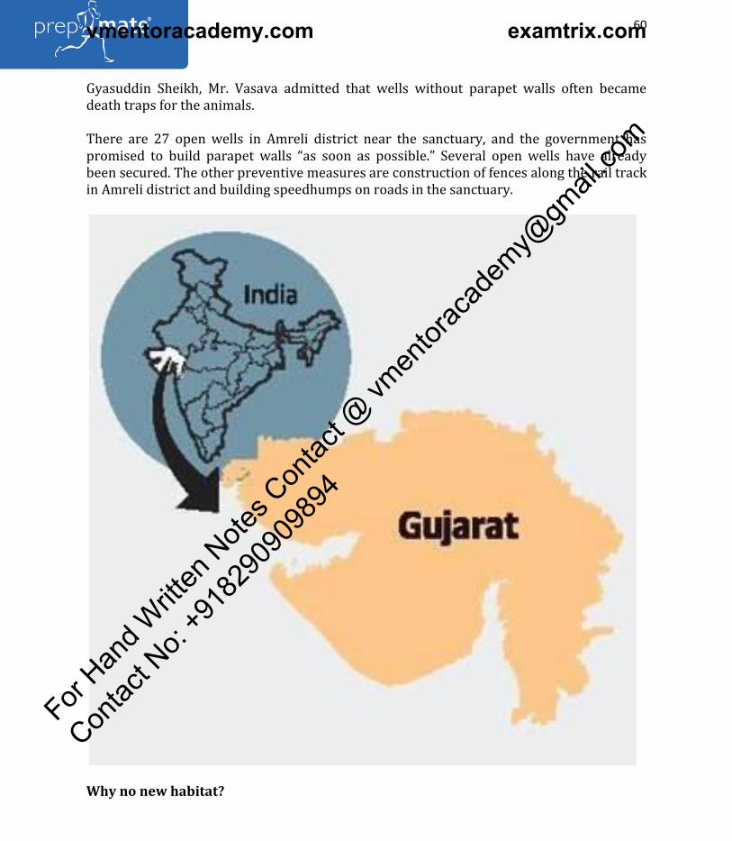
For updates on WhatsApp, share your name & city on WhatsApp No. 75978-30000
60
Website: www.prepmate.in Telegram Channel: @upscprepmate
Prepmate Cengage Books Preview: https://prepmate.in/books/ Youtube channel: PrepMate Edutech
Gyasuddin Sheikh, Mr. Vasava admitted that wells without parapet walls often became
death traps for the animals.
There are 27 open wells in Amreli district near the sanctuary, and the government has
promised to build parapet walls as soon as possible. Several open wells have already
been secured. The other preventive measures are construction of fences along the rail track
in Amreli district and building speedhumps on roads in the sanctuary.
Why no new habitat?
For Han
d Writt
en N
otes C
ontac
t @ vm
entor
acad
emy@
gmail
.com
Contac
t No:
+918
2909
0989
4
vmentoracademy.com examtrix.com
For updates on WhatsApp, share your name & city on WhatsApp No. 75978-30000
61
Website: www.prepmate.in Telegram Channel: @upscprepmate
Prepmate Cengage Books Preview: https://prepmate.in/books/ Youtube channel: PrepMate Edutech
As per the 2015 census, there were 523 lions in and around the Gir sanctuary.
Unfortunately, though the total population of Asiatic lions increased from 359 in 2005 to
523 in 2015, no new protected habitat was approved by the State government since 2008.
As stated in the CAG report, the number of lions outside the protected area in 2011 was
108, which increased by 54.6% to 167 in 2015. The Gir Protected Area includes the Gir,
Girnar, Paniya and Mitiyala sanctuaries and the Gir National Park. To provide a safe
corridor for the lions moving out of the Gir Protected Area, the Chief Conservator of Forests
(Wildlife) had proposed a new sanctuary spread over 30,000 hectares in Amreli and
Bhavnagar districts in 2005. Later, the plan was revised, and the new region was proposed
to be a conservation reserve (CR) spread across 10,953 hectares. The CAG observed that as
on May 2017, the Revenue Department had not transferred 4,800 hectares of wasteland to
the Forest Department for setting up the conservation reserve.
Thus, the declaration of the lion habitat area as a conservation reserve is pending despite
the lapse of 11 years, it said. It questioned the non-approval of a new protected area
despite high instances of deaths of lions in their present habitat. The CAG also pointed out
that the genome mapping project was being handled by an agency which did not possess
the expertise, and the progress was slow.
What is their future?
The government, which has always taken pride in showcasing Gujarat as the only habitat of
Asiatic lions, refuses to translocate some of them to Madhya Pradesh despite a Supreme
Court order. It must make sincere efforts to provide adequate protection to the animals
moving out to non-protected areas. It must increase the size of the protected areas to
prevent more lions from dying, wildlife experts say.
(Adapted from The Hindu)
18. Environment Ministry notifies Plastic Waste Management (amendment) rules
The Ministry of Environment, Forest and Climate Change has notified the Plastic Waste
Management (Amendment) Rules 2018. The amended Rules lay down that the phasing out
of Plastics is now applicable to Multilayered Plastic (MLP), which are non-recyclable, or
non-energy recoverable, or with no alternate use.
Central Registration system
The amended Rules also prescribe a central registration system for the registration of the
producer/importer/brand owner. The Rules also lay down that any mechanism for the
registration should be automated and should take into account ease of doing business for
producers, recyclers and manufacturers. The centralized registration system will be
evolved by Central Pollution Control Board (CPCB) for the registration of the
producer/importer/brand owner. While a national registry has been prescribed for
producers with presence in more than two states, a state-level registration has been
prescribed for smaller producers/brand owners operating within one or two states.
For Han
d Writt
en N
otes C
ontac
t @ vm
entor
acad
emy@
gmail
.com
Contac
t No:
+918
2909
0989
4
vmentoracademy.com examtrix.com
For updates on WhatsApp, share your name & city on WhatsApp No. 75978-30000
62
Website: www.prepmate.in Telegram Channel: @upscprepmate
Prepmate Cengage Books Preview: https://prepmate.in/books/ Youtube channel: PrepMate Edutech
Plastic Waste Management Rules, 2016
Based on several representations received from various stakeholders, MoEF&CC had
constituted a committee on issues/challenges faced with regard to the implementation of
Plastic Waste Management Rules, 2016 and Solid Waste Management Rules, 2016. The
committee deliberated on several issues related to the Rules and its implementation by
various stakeholders and submitted its recommendations to the Ministry.
What are Multilayered Plastic (MLP)?
Multi-layered plastics are made up of a layered composition of various types of plastics.
Sometimes, the plastics material is also combined with non-plastics such as aluminium foil.
Multi-layered plastics products are difficult to be recycled.
Mixed plastics streams are generally separated on the basis of their density for purpose of
recycling.
(Adapted from PIB)
19. Centre proposes relaxation of coastal regulation zone norms
States to get leeway in developing tourism, industrial infrastructure
The Centre has allowed India s coasts to be made more accessible to tourism and industrial
infrastructure and given individual States considerable leeway to decide how they should
plan such development, according to a draft version of the proposed modification to India s
coastal regulation zone plan made public on the Environment Ministry website.
For Han
d Writt
en N
otes C
ontac
t @ vm
entor
acad
emy@
gmail
.com
Contac
t No:
+918
2909
0989
4
vmentoracademy.com examtrix.com
For updates on WhatsApp, share your name & city on WhatsApp No. 75978-30000
63
Website: www.prepmate.in Telegram Channel: @upscprepmate
Prepmate Cengage Books Preview: https://prepmate.in/books/ Youtube channel: PrepMate Edutech
Coastal regulation zone - 2011
The coastal regulation zone, or CRZ, 2011, refers to regions in the proximity of India s
7000-km-long shoreline where buildings, tourism facilities, industrial projects, residential
facilities etc are highly regulated. In most cases it begins from the high tide line (HTL) to
about 500 metres towards the landward side. The zone is subdivided into regions, with
varying leeway for infrastructure development, depending on population and ecological
sensitivity.
The CRZ-1, for instance, includes the most ecologically sensitive areas and according to
current laws is off-limits for tourism activities and infrastructure development except for
defence, strategic and rare public utilities projects.
Coastal regulation zone - 2018
According to the new CRZ, 2018 notification . nature trails and eco-tourism activities. may
be permitted in CRZ-1 regions provided they conform to state-approved coastal zone
management plans.
Change in definition of Coastal Zone
The current law, called the CRZ, 2011 also defines as coastal zone, the region from the HTL
to 100 m of the creek along tidal-influenced bodies such as bays, estuaries, rivers,
backwaters, lagoons and ponds etc. that are connected to the sea. The proposed laws relax
this to 50 metres.
Earlier, rural habitations or relatively undisturbed areas close to the shore, called CRZ-II,
possessed a 200 metre no development zone . This has now been reduced to 50 metres,
provided the area has a population density exceeding 2161 per square kilometre as per the
2011 Census.
(Adapted from The Hindu)
20. What the new Coastal Regulation Zone draft says, how it differs from the earlier
version
The new draft if implemented will not only have an effect on how common areas used by
fisherfolk are managed, but also bifurcate coastal zones along rural areas based on
population density.
The draft Coastal Regulation Zone (CRZ), 2018, which was released by the Ministry of
Environment and Forests (MoEF) last week, has the potential to change the way coastal
stretches in India are governed. India s coastline runs over 7,500 kilometres.
The new draft if implemented will not only have an effect on how common areas used by
fisherfolk are managed, but also bifurcate coastal zones along rural areas based on
population density. Environmentalists claim that the draft has opened up fragile inter-tidal
For Han
d Writt
en N
otes C
ontac
t @ vm
entor
acad
emy@
gmail
.com
Contac
t No:
+918
2909
0989
4
vmentoracademy.com examtrix.com
For updates on WhatsApp, share your name & city on WhatsApp No. 75978-30000
64
Website: www.prepmate.in Telegram Channel: @upscprepmate
Prepmate Cengage Books Preview: https://prepmate.in/books/ Youtube channel: PrepMate Edutech
areas to real estate agents and framed with an intent to favour large-scale industry at the
cost of fishing communities.
Changes in the new draft
The purpose of the current notifications vis-à-vis the previous one released in 2011
remains more or less the same. The new draft aims to conserve and protect the unique
environment of coastal stretches and marine areas, besides livelihood security to the fisher
communities and other local communities in the coastal areas and to promote sustainable
development based on scientific principles taking into account the dangers of natural hazards, sea level rises due to global warming….
A major change in the new draft pertains to the CRZ limits on land along tidal influenced
water bodies . The proposed limit has been reduced from 100 metres to 50 metres or the
width of the creek, whichever is less.
Mapping of high tide and hazard lines
The draft makes the National Centre for Sustainable Coastal Management (NCSCM) the final
authority to lay down standards for High Tide Line (HTL). Earlier the demarcation was
carried out by one of the agencies authorised by MoEF, on recommendations of the NCSCM.
The hazard line, which was demarcated by the Survey of India (SOI), has been delinked
from the CRZ regulatory regime, and will now be used as a tool for disaster management
and planning of adaptive and mitigation measures. Pooja Kumar from the Chennai-based
Coastal Resources Centre points out that the 2011 notification placed a lot of importance
on the hazard line. The 2018 notification takes away the protection that the hazard line
could provide; instead, it merely states that the hazard line should be used as a tool for
disaster management. This means that one can build in these areas after preparing an
environment assessment report stating that certain precautions have been considered,
she said.
Bifurcation of CRZ-III areas
CRZ-III areas — land that is relatively undisturbed such as in rural areas, and do not fall in
areas considered close to shoreline within existing municipal limits — have been divided
into two categories:
CRZ-III A refers to rural areas with a population density of 2,161 people per square
kilometre or more as per the 2011 Census. Such areas shall have a No Development Zone
(NDZ) of 50m from the HTL, the draft notes.
CRZ-III B refers to rural areas with a population density lesser than 2,161 people per
square kilometre. Such areas shall continue to have an NDZ of 200m from the HTL.
For Han
d Writt
en N
otes C
ontac
t @ vm
entor
acad
emy@
gmail
.com
Contac
t No:
+918
2909
0989
4
vmentoracademy.com examtrix.com

For updates on WhatsApp, share your name & city on WhatsApp No. 75978-30000
65
Website: www.prepmate.in Telegram Channel: @upscprepmate
Prepmate Cengage Books Preview: https://prepmate.in/books/ Youtube channel: PrepMate Edutech
Kumar questions the accuracy of data that is used for classification. We had a look at 2011
Census [data], and only state-wise population density is available, so how does one narrow
down to the coastal region? she enquires.
Kanchi Kohli, a researcher at the Centre for Policy Research, pointed out that revenue
records are not available of how many people live in some of the CRZ-III areas. They
[through the draft] want to open up certain parts of the coast. It is clear that the state
governments have asked for this. Some of these common areas are used by fisherfolk to dry
fish and park their boats, she said.
Projects that require MoEF s approval
Only those projects located in CRZ-I (environmentally most critical) and CRZ-IV (water and
seabed areas) shall require MoEF clearance. All other projects shall be considered by
Coastal Zone Management Authorities (CZMAs) in the states and union territories.
The draft also allows for construction of roads and roads on stilts, by way of reclamation
in CRZ-1 areas , only in exceptional cases for defence, strategic purposes and public
utilities, to be recommended by the CZMA and approved by the Ministry. However, it does
not explicitly state what strategic projects are.
Interestingly, it notes that in cases where roads are constructed through mangroves or are
likely to damage the latter, a minimum three times the mangrove area affected/ destroyed/ cut during the construction… shall be taken up for compensatory plantation….
Floor space index for CRZ-II
While the 2011 notification had frozen the floor space index or floor area ratio for CRZ-II
areas at 1991 Development Control Regulation (DCR) levels, the new draft proposes to de-
freeze the same and permit FSI for construction projects as prevailing on the date of the
new notification.
Kohli points out that certain kinds of buildings in metro cities such as Chennai and Mumbai
have been exempted from CRZ -II areas. Certain buildings will be managed by FSI through
Town and Country Planning Department, and will not require CRZ clearances, she said.
Criticism
Kohli notes that the draft empowers CZMAs at the state-level, which is responsible for the
Coastal Zone Management Plans (CZMPs). The idea is to complete the process of drawing
up plans in consultation with coastal dwellers. Land and sea are constantly merging. As a
result, this cannot be done through satellite images. One has to visit the area… The issue is that the process of creating CZMPs is flawed…, she said.
The MoEF has said that the relaxations/ amendment proposed in the CRZ notification,
2018, shall come into effect only after respective CZMPs that were to be framed under the
For Han
d Writt
en N
otes C
ontac
t @ vm
entor
acad
emy@
gmail
.com
Contac
t No:
+918
2909
0989
4
vmentoracademy.com examtrix.com

For updates on WhatsApp, share your name & city on WhatsApp No. 75978-30000
66
Website: www.prepmate.in Telegram Channel: @upscprepmate
Prepmate Cengage Books Preview: https://prepmate.in/books/ Youtube channel: PrepMate Edutech
previous CRZ notification, have been revised or updated by states/UTs and approved by
the ministry.
The National Green Tribunal has noted that it has been seven years since the deadline set
by the 2011 notification to submit CZMPs to the MoEF has passed. Several states have held
public hearings in this regard. While Maharashtra has requested an extension, the public
hearing in Ramanathapuram in Tamil Nadu was forcibly cancelled last week due to
opposition from fisherfolk.
According to Pooja Kumar, the dilutions introduced by the new draft will affect customary
land use and traditional land rights. It does maintain the language of long-term housing
plans. What is the point of it if livelihoods and related spaces are not taken care of?
Coastal spaces are fluid. Applying models that pertain to inland areas to the coast is problematic… Delhi and its corridors of power lack an understanding of what these places are, Kohli said.
(Adapted from The Indian Express)
21. WHO highlights the air pollution crisis in urban India
14 Indian cities among the 20 most polluted
A new report from the World Health Organization highlights not only how widespread air
pollution is in urban India, but also how deficient air quality monitoring is. The report,
which summarized 2016 data for 4,300 cities, ranks 14 Indian cities among the 20 most
polluted ones globally.
While Delhi comes in at number six, Kanpur, Faridabad, Varanasi, Gaya and Patna are
ranked ahead of it, by PM 2.5 levels. And yet, Kanpur, Faridabad and several other
pollution-choked cities have only one PM 2.5 monitoring station each, while Delhi has
several.
Other sources of collecting data
WHO researchers get around this problem by using alternative data sources such as
satellite remote sensing and chemical transport models, along with ground-monitoring
stations.
The outcome of this exercise makes it clear that air pollution is not a problem of large
metropolises alone, even though they have traditionally been the focus of mitigation
efforts.
Such wide variations in data quality exist across the world. While Europe has the most
extensive monitoring network, countries in Africa and the Western Pacific region perform
poorly.
For Han
d Writt
en N
otes C
ontac
t @ vm
entor
acad
emy@
gmail
.com
Contac
t No:
+918
2909
0989
4
vmentoracademy.com examtrix.com
For updates on WhatsApp, share your name & city on WhatsApp No. 75978-30000
67
Website: www.prepmate.in Telegram Channel: @upscprepmate
Prepmate Cengage Books Preview: https://prepmate.in/books/ Youtube channel: PrepMate Edutech
This means data from these regions are of poor quality, and likely underestimates,
resulting in an under-count of the disease burden as well.
Other findings of the report
1. The report puts the global death toll from air pollution at seven million a year,
attributable to illnesses such as lung cancer, pneumonia and ischemic heart disease. In
2016 alone, it says, around 4.2 million people died owing to outdoor air pollution, while 3.8
million people succumbed to dirty cooking fuels such as wood and cow dung.
2. About a third of these deaths occurred in Southeast Asian countries, which include India.
Once monitoring improves in these regions, the numbers will likely be revised upwards.
Praise for Pradhan Mantri Ujjwala Yojana scheme
There are silver linings, however. The report had words of praise for India s Pradhan
Mantri Ujjwala Yojana scheme, which has provided 37 million women living below the
poverty line with LPG (liquefied petroleum gas) connections. Such schemes will also help
cut the indoor air pollution that plagues much of rural India, which is not covered in the
WHO analysis.
Possible high pollution in rural areas
It is important to remember, though, that rural India has problems beyond inefficient cook-
stoves. As the recently published draft National Clean Air Programme noted, there are
currently no air pollution monitoring stations in rural India. This does not mean outdoor
air pollution is not a problem here. Studies have shown that ozone levels are higher in rural
areas, as is pollution from insecticide use and crop-burning. The WHO has asked Southeast
Asian countries to take swift action to tackle the twin problems of indoor and outdoor
pollution. India must realize that its problems are larger than the WHO estimates, and take
the call to action seriously.
(Adapted from The Hindu)
22. The lowdown on falling water reserves
What is it?
India s groundwater resources have been overexploited, as experts have been warning for
some time now. According to a sample assessment in 2011, groundwater in 19 of India s 71
districts — about 26% — were critical or exploited, meaning that nearly as much or more
water was being pulled out than their reservoirs natural recharge ability. In another
assessment in 2013, they included groundwater blocks in districts that had gone saline, and
this percentage was up to 31%. Groundwater is exploited unequally. The maximum
overdraft is in the northwestern States of Rajasthan, Punjab and Haryana. The latter two
are key wheat granaries and, despite developed canal-networks, rely extensively on
groundwater. The overall contribution of rainfall to the country s annual groundwater
For Han
d Writt
en N
otes C
ontac
t @ vm
entor
acad
emy@
gmail
.com
Contac
t No:
+918
2909
0989
4
vmentoracademy.com examtrix.com

For updates on WhatsApp, share your name & city on WhatsApp No. 75978-30000
68
Website: www.prepmate.in Telegram Channel: @upscprepmate
Prepmate Cengage Books Preview: https://prepmate.in/books/ Youtube channel: PrepMate Edutech
resource is 68%, and the share of other resources, such as canal seepage, return flow from
irrigation, recharge from tanks, ponds and water conservation structures, taken together is
32%. Moreover, the population increase has meant that the national per capita annual
availability of water has reduced from 1,816 cubic metre in 2001 to 1,544 cubic metre in
2011, a 15% reduction.
How has this come about?
There are many reasons for the decline. Statistics show that right from the mid-1960s,
India s canal network was not keeping pace with farmers water demand. Therefore, many
of them started installing tubewells to keep up with the needs of Green Revolution-crops
that required more water and fertilizer. Free electricity, to pump this water, too helped.
Over the last two decades, an overall decline in the quantum of pre-monsoon rainfall has
increased dependence on groundwater. For instance, India has registered a sharp decline
in its pre-monsoon rainfall this year. Between March 1 and the first week of May, the
country should have got at least 70 mm of rain, but has only got 55 mm, or a 20% deficit.
The immediate signs of deficit are visible in water storage.
Why does this matter?
According to figures from the Central Water Commission, India s key reservoirs are, as of
this week, 10% short of their decadal average for this time of the year. Less water from
these sources means increased pressure on India s groundwater reserves for irrigating the
summer crop and drinking and industrial use. The fracas between Tamil Nadu and
Karnataka over sharing of Cauvery waters also has a groundwater angle. The Supreme
Court, in a major judgment in February, directed that Tamil Nadu use 10 TMC (thousand
million cubic feet) of its groundwater instead of banking on Cauvery waters from
Karnataka. The judgment even said groundwater, if not extracted regularly, would be
wasted, thus sanctioning the use of groundwater as a reserve to be exploited at will.
Other than groundwater being a reserve to be used judiciously, over-exploitation poses
health risks. West Bengal, Odisha, Uttar Pradesh, Bihar and Jharkhand face severe problems
of arsenic contamination, and one of the causes is drawing water from increasingly greater
depths. Punjab and Haryana have for years reported a spike in cancer cases owing to
chemical fertilizers leaching into the soil.
What lies ahead?
There have been several attempts to get the States to use groundwater more responsibly.
The Centre has a model groundwater Bill that is not binding on the States. However, 11
States and four Union Territories have adopted it. But the legislation has had limited
impact on groundwater exploitation. Last year, the Union Water Ministry brought in a Bill
that would require various classes of users to pay for the groundwater they use. More
importantly, it tries to change how groundwater is viewed as a resource. Currently, the
owner of a piece of land is deemed the owner of the groundwater below it. This Bill
attempts to put the State as the custodian of the groundwater. It remains to be seen
whether the States will come around to this perspective.
For Han
d Writt
en N
otes C
ontac
t @ vm
entor
acad
emy@
gmail
.com
Contac
t No:
+918
2909
0989
4
vmentoracademy.com examtrix.com
For updates on WhatsApp, share your name & city on WhatsApp No. 75978-30000
69
Website: www.prepmate.in Telegram Channel: @upscprepmate
Prepmate Cengage Books Preview: https://prepmate.in/books/ Youtube channel: PrepMate Edutech
(Adapted from The Hindu)
23. Why the Taj is losing its colour?
The Supreme Court said last week that the Archaeological Survey of India (ASI) will have
to be thrown out of the picture if the Taj Mahal was to be saved, and the Centre informed
the court that it was considering the suggestion to involve international experts in the
conservation of the 17th-century monument. The court had earlier expressed concern over
the marble of the Taj changing colour, and asked how the white marble, which had first
become yellowish, was now turning brownish and greenish. The court has been hearing a
plea filed by M C MEHTA, perhaps India s best-known environmentalist, seeking protection
for the Taj from pollution.
Acting on a similar petition filed by Mehta, the court had in 1996 ordered a slew of
measures, including the closure of factories in the vicinity, to protect the monument. Over
two decades later, Mehta tells SOMYA LAKHANI how successive governments in New Delhi
and Lucknow, and the Archaeological Survey of India, have failed to implement the court s
order, and how a dying Yamuna and the insects that breed in it are killing the Taj.
What has led to the change of colour of the Taj Mahal s marble?
There are various factors that have led to the discoloration of the Taj Mahal. Firstly, the
polluting industries and the vehicular emissions in the Taj Trapezium Zone (TTZ) area are
a major source of pollution. The second reason is that the Yamuna river, which flows
behind the Taj, has become highly polluted. There is no aquatic life in it, and has caused
insect and algae infestation on the Taj Mahal and other monuments situated on its banks.
How exactly do insects damage the Taj?
The source of this problem comes from the dry river Yamuna, which has become devoid of
any ecological flow. These insects, as has been stated in the Archaeological Survey of India s
report, breed in the polluted matter in the river, and then attack the Taj Mahal in the
evening. Earlier, there were fish in the river, which ate the insects and their larvae, but
now, due to the serious water pollution, there is no sign of any aquatic species in the river.
And how have the patches on the marble of the Taj appeared?
As stated in the ASI s A Report on Insect Activities at Taj Mahal And Other Monuments of
Agra, the green and black patches developed due to the presence of a specific type of
insects, mainly on the northern side of the Taj Mahal. Other monuments that stand on the
banks of the river Yamuna, such as the Tomb of Itimad-ud-Daulah, the Mehtab Bagh, and
portions of the Agra Fort, too, have been affected by these insect attacks.
How bad is the problem of air pollution?
Due to the lackadaisical approach of the central and state governments, Agra has become
the world s eighth most polluted city in terms of PM 2.5 levels, as per a WHO Report
For Han
d Writt
en N
otes C
ontac
t @ vm
entor
acad
emy@
gmail
.com
Contac
t No:
+918
2909
0989
4
vmentoracademy.com examtrix.com

For updates on WhatsApp, share your name & city on WhatsApp No. 75978-30000
70
Website: www.prepmate.in Telegram Channel: @upscprepmate
Prepmate Cengage Books Preview: https://prepmate.in/books/ Youtube channel: PrepMate Edutech
released this month. The Parliamentary Standing Committee on Science and Technology,
Environment and Forests in its 262nd Report on the effects of pollution on the Taj Mahal,
presented to Rajya Sabha and Lok Sabha in 2015, pointed out that air pollution has become
a concern not only for reasons of health of the common man, but also for the danger it
poses to cultural heritage. Rampant construction and encroachments compound the
problem.
The Supreme Court has said that the ASI will have to be thrown out of the picture if
the Taj is to be saved. What can foreign experts do to save the Taj that the ASI
cannot?
The experience shows that the situation, instead of getting remedied, has worsened, and
has reached a critical point. It needs thorough investigation and solutions from renowned
experts and institutions working in the field of conservation and preservation. Since the Taj
Mahal is a World Heritage Site, if an opinion is sought from both national and international
experts and institutions, it will give a broader perspective and vision to protect the
monument.
The court had earlier expressed concern over the marble of the Taj changing colour, and
asked how the white marble, which had first become yellowish, was now turning brownish
and greenish.
How is the situation today compared to what it was when you first brought out the
problems with the Taj?
For Han
d Writt
en N
otes C
ontac
t @ vm
entor
acad
emy@
gmail
.com
Contac
t No:
+918
2909
0989
4
vmentoracademy.com examtrix.com

For updates on WhatsApp, share your name & city on WhatsApp No. 75978-30000
71
Website: www.prepmate.in Telegram Channel: @upscprepmate
Prepmate Cengage Books Preview: https://prepmate.in/books/ Youtube channel: PrepMate Edutech
In 1984, when the case was filed in the Supreme Court for the protection of the Taj Mahal,
the situation was much better as compared to the present. The Hon ble Supreme Court
gave a clear roadmap by issuing various directions, including declaring Agra a Heritage
City. Had successive central and state governments taken all measures to declare Agra a
Heritage City, the situation would perhaps have become ideal.
Today, 35 years after you first approached the Supreme Court, we seem to be still debating
the same issues that we started out with. What went wrong with the conservation effort?
Rather than taking measures to declare Agra a Heritage City, the authorities have actually
encouraged polluters and allowed projects that were detrimental to environment
protection and the conservation of monuments within the Taj Trapezium Zone.
(Adapted from The Indian Express)
24. India Calls for Judicious Use of Resources at 4th Brics Ministerial Meeting in
Durban
India has called for a judicious use of resources amidst concerns over resource depletion
and scarcity. Addressing the 4th BRICS Ministerial meeting in Durban, South Africa, Union
Minister for Environment, Forest and Climate Change, Dr. Harsh Vardhan has said that a
decrease in global materials, or at least stabilization at present levels, demand major
reductions in metabolic rates in the Asia-Pacific region, especially India.
He pointed out that this can become possible only through Resource Efficiency (RE) not
only throughout the material life cycle, but also at the post-consumption stage. The
Minister added that secondary resources (waste materials) need to be brought back into
production, adopting a Circular Economy (CE) approach.
What is Circular Economy (CE) approach?
A circular economy is a regenerative system in which resource input and waste, emission,
and energy leakage are minimised by slowing, closing, and narrowing energy and material
loops. This can be achieved through long-lasting design, maintenance, repair, reuse,
remanufacturing, refurbishing, and closed recycling loops. This is in contrast to a linear
economy which is a 'take, make, dispose' model of production.
A major argument in favour of the circular economy approach is that achieving a
sustainable world does not require changes in the quality of life of consumers, nor it
requires loss of revenues or extra costs for manufacturers and other economic agents. The
argument is that circular business models can be as profitable as linear models and allow
consumers to keep enjoying similar products and services.
For Han
d Writt
en N
otes C
ontac
t @ vm
entor
acad
emy@
gmail
.com
Contac
t No:
+918
2909
0989
4
vmentoracademy.com examtrix.com

For updates on WhatsApp, share your name & city on WhatsApp No. 75978-30000
72
Website: www.prepmate.in Telegram Channel: @upscprepmate
Prepmate Cengage Books Preview: https://prepmate.in/books/ Youtube channel: PrepMate Edutech
To achieve models that are economically and environmentally sustainable the circular
economy focuses on areas such as design thinking, systems thinking, product life extension,
and recycling.
One example of a circular economy model is the implementation of renting models in
traditional ownership areas (e.g. electronics, clothes, furniture, transportation). Through
renting the same product to several clients, manufactures can increase revenues per unit,
thus decreasing the need to produce more to increase revenues. Recycling initiatives are
often described as circular economy and are likely to be the most widespread models
(Adapted from PIB)
25. How to handle heatstrokes
For Han
d Writt
en N
otes C
ontac
t @ vm
entor
acad
emy@
gmail
.com
Contac
t No:
+918
2909
0989
4
vmentoracademy.com examtrix.com

For updates on WhatsApp, share your name & city on WhatsApp No. 75978-30000
73
Website: www.prepmate.in Telegram Channel: @upscprepmate
Prepmate Cengage Books Preview: https://prepmate.in/books/ Youtube channel: PrepMate Edutech
What can be consequence of a heatstroke?
For Han
d Writt
en N
otes C
ontac
t @ vm
entor
acad
emy@
gmail
.com
Contac
t No:
+918
2909
0989
4
vmentoracademy.com examtrix.com

For updates on WhatsApp, share your name & city on WhatsApp No. 75978-30000
74
Website: www.prepmate.in Telegram Channel: @upscprepmate
Prepmate Cengage Books Preview: https://prepmate.in/books/ Youtube channel: PrepMate Edutech
With the mercury soaring over 40 degrees Celsius mark, doctors have warned against
heatstroke and related medical condition stating that it is a medical emergency and can be
fatal if not promptly and properly treated.
While heatstroke may appear to be a short-lived medical episode, if ignored, it can become
a serious cardio or a neuro concern, said doctors.
He added that heatstroke usually causes nausea, cramps, irritation, disorientation, and in
extreme cases induce coma.
Physicians have also said that chronic conditions such as diabetes can become tougher to
manage in summers. Extreme heat causes blood glucose levels to fluctuate drastically apart
from leading to dehydration and exhaustion. Unless one takes adequate precautions, this
can lead to heatstrokes.
Who can be affected?
Although heatstroke mainly affects people with low tolerance levels/immunity [mainly
elderlies], it can also take a toll on a younger age bracket. It is important to stay hydrated
and calm during this weather. If a person is feeling dizzy or suffering from heat cramps
[rapid pulse, rapid breathing, and headache], he should immediately seek medical
treatment as this can cause serious cardio and neuro problems in the future, he said.
Why does heatstroke occur?
Heatstrokes and related medical conditions have become common and it is important to be
aware and be prepared to deal with it. Heatstrokes occur due to a prolonged exposure to
high temperatures, clubbed with poor hydration levels which lead to failure of body s
temperature control system.
What can be possible preventions?
People face dehydration. People tend to form a habit of drinking less water during winters,
which continues with the initial summer months. It is important that the bodies are kept
hydrated by increasing our fluid intake, including juice, traditional lemonades, and water.
(Adapted from the Hindu)
26. Green Good Deeds Movement
Green Good Deeds, the societal movement launched by the Union Minister for
Environment, Forest & Climate Change, Dr Harsh Vardhan, to protect environment and
promote good living in the country, has found acceptance by the global community.
Adopted at BRICS Environment meeting
For Han
d Writt
en N
otes C
ontac
t @ vm
entor
acad
emy@
gmail
.com
Contac
t No:
+918
2909
0989
4
vmentoracademy.com examtrix.com
For updates on WhatsApp, share your name & city on WhatsApp No. 75978-30000
75
Website: www.prepmate.in Telegram Channel: @upscprepmate
Prepmate Cengage Books Preview: https://prepmate.in/books/ Youtube channel: PrepMate Edutech
The ongoing BRICS Ministerial on Environment at Durban, South Africa, has agreed to
include Green Good Deeds in its official agenda in the next Ministerial in Brazil and
another meeting in Russia.
What are Green Good Deeds?
Dr. Harsh Vardhan had formally launched the nation-wide campaign in January 2018. He
enlisted the cooperation of thousands of people – students, teachers, voluntary
organisations, Residents Welfare Associations and professionals to adopt these deeds. The
Ministry of Environment, Forest & Climate Change had drawn up a list of over 500 Green
Good Deeds and asked people to alter their behaviour to Green Good Behaviour to fulfil
their Green Social Responsibility. These small, positive actions, to be performed by
individuals or organisations to strengthen the cause of environmental protection have been
put up on a mobile App named Dr Harsh Vardhan .
(Adapted from PIB)
27. How heat footprint has grown
For Han
d Writt
en N
otes C
ontac
t @ vm
entor
acad
emy@
gmail
.com
Contac
t No:
+918
2909
0989
4
vmentoracademy.com examtrix.com

For updates on WhatsApp, share your name & city on WhatsApp No. 75978-30000
76
Website: www.prepmate.in Telegram Channel: @upscprepmate
Prepmate Cengage Books Preview: https://prepmate.in/books/ Youtube channel: PrepMate Edutech
A new study that used comprehensive surface temperature data to record changes in daily
mean temperatures across India over seven decades has found a consistent pattern of
warming over the northwestern and southern parts of the country from the 1950s to the
2000s, even as the broad zone anchored over northeastern India and extending
southwestward across central India saw a pattern of cooling during this period.
The results, published recently in Scientific Reports, a journal of the Nature group, have
been reported by Robert S Ross and T N Krishnamurti of Florida State University, Sandeep
Pattnaik of IIT-Bhubaneswar, and D S Pai of the India Meteorological Department. The
study has examined the patterns in the overall warming of the planet that has accelerated
since the 1950s, and its possible impact on Indian agriculture. ( Decadal surface
temperature trends in India based on a new high resolution data set : Scientific Reports 8:
2018)
What is the key finding of the study?
For Han
d Writt
en N
otes C
ontac
t @ vm
entor
acad
emy@
gmail
.com
Contac
t No:
+918
2909
0989
4
vmentoracademy.com examtrix.com

For updates on WhatsApp, share your name & city on WhatsApp No. 75978-30000
77
Website: www.prepmate.in Telegram Channel: @upscprepmate
Prepmate Cengage Books Preview: https://prepmate.in/books/ Youtube channel: PrepMate Edutech
Essentially that while the decade mean maximum surface temperatures over India in the
pre-monsoon months in the 1950s showed limited areas with values as high as 40°C , by
the 2010s, the area with values exceeding 40°C had expanded to include the majority of
the Indian peninsula, with peak values in south-central India reaching 42°C . At the same
time, there is a definite, and somewhat surprising, cooling (or in some instances, reduced
warming) in the Northeast over these decades — a pattern of warming and cooling that is
explained by the presence of a large region of anthropogenic brown haze over India and
the adjacent ocean regions , especially in the winter and spring. The haze , the researchers
say, is composed of aerosols that absorb solar radiation, which reduces insolation at the
Earth s surface leading to cooling, while increasing absorption in the aerosol layer leading
to warming .
On what data is the study based?
An examination of all-India surface mean temperature anomalies for 1901-2016 reveals an
unmistakable rapid rise, particularly since about 1980, as seen in annual, winter, pre-
monsoon, monsoon and post-monsoon period depictions , notes the study. Beginning from
this observation, the researchers focussed on a recently developed comprehensive surface
temperature data set for India for 1969-2005, a range that was subsequently expanded to
1951-2013. Temperature data from 395 Indian meteorological stations were categorised
into the periods April 1-May 31 (pre-monsoon), July 1-September 30 (monsoon), and
January 1-March 31 (winter), for which researchers looked at the maximum, minimum and
daily mean temperatures.
And what do the data suggest?
In the 1950s, the area with a mean maximum temperature higher than 40°C was small —
only one spot in south-central India showed values ~ 41°C. The region with values greater
than 40°C begins to expand in the 1970s and 1980s and (that) with values greater than
41°C in south-central India enlarges , says the study. A very slight fall is seen in the 1990s,
and then, the region with temperatures greater than 40°C expands dramatically in the
2000s and the 2010s, (that) with temperatures greater than 41°C expands, and a region
with temperature greater than 42°C appears in south-central India in the 2010s . Also, a
notable warming trend that begins in northwestern India in the 1970s, accelerates in the
2000s ad 2010s. The broad conclusion: These decadal mean temperature patterns suggest
that global warming is manifesting itself over parts of India in the maximum temperatures
observed during the warm pre-monsoon period, with an accelerating pace noted,
particularly in the last two decades.
What do these findings imply?
India, the researchers underline, is more vulnerable to climate change because its
agricultural system must feed 17.5% of the world s population with only 2.4% of the land
and 4% of the water resources of the planet . A mid-range projection of climate change for
For Han
d Writt
en N
otes C
ontac
t @ vm
entor
acad
emy@
gmail
.com
Contac
t No:
+918
2909
0989
4
vmentoracademy.com examtrix.com

For updates on WhatsApp, share your name & city on WhatsApp No. 75978-30000
78
Website: www.prepmate.in Telegram Channel: @upscprepmate
Prepmate Cengage Books Preview: https://prepmate.in/books/ Youtube channel: PrepMate Edutech
2020-39 has indicated a reduction in crop yields of between 4.5% and 9%, the study says.
One point of comfort: maps of multi-decadal temperature change show that the primary
rice- and sorghum-growing regions lie directly in the swath of multi-decadal temperature
cooling (or reduced warming) , which may indicate relatively less stress for these
critical growing areas .
(Adapted from The Indian Express)
28. Clean Air India Initiative launched)
Who has launched Clean Air India Initiative ?
Prime Minister of Netherlands Mark Rutte, who is in India on a two-day visit, launched the
Clean Air India Initiative in the national capital. The campaign aims to curb air pollution in
Indian cities by promoting partnerships between Indian start-ups and Dutch companies
and build a network of entrepreneurs working on business solutions for cleaner air.
What is the initiative?
The Clean Air India Initiative is a collaborative project between Get In The Ring, a platform
for start-ups, the government of the Netherlands, Start-up India, and INDUS Forum, an
online matchmaking platform of Indian and Dutch businesses.
How it involves a business opportunity?
A major business opportunity for Dutch firms that was highlighted included the potential
for sale of equipment (such as sensors), data, and solutions concerning air quality
monitoring (AQM), with experts estimating that 80% of India is not covered by AQM data
collecting which is the first step toward monitoring and combating air pollution.
Start from reducing Paddy stubble burning
Also, under focus was the severe air pollution in Delhi caused by the burning of paddy
straw in neighboring Haryana and Punjab. An INDUS impact projects aims to halt the
hazardous burning of paddy stubble by promoting business partnerships that upcycle it.
This entails using paddy straw as feedstock to make materials that would find use in
construction and packaging — a technology and expertise that Dutch companies are keen
to market in India.
(Adapted from The Hindu)
29. Need for water management reforms
On the cusp of the southwest monsoon, several arid States are hoping to revive their rivers
and reservoirs with bountiful rain.
Situation in Gujarat
For Han
d Writt
en N
otes C
ontac
t @ vm
entor
acad
emy@
gmail
.com
Contac
t No:
+918
2909
0989
4
vmentoracademy.com examtrix.com

For updates on WhatsApp, share your name & city on WhatsApp No. 75978-30000
79
Website: www.prepmate.in Telegram Channel: @upscprepmate
Prepmate Cengage Books Preview: https://prepmate.in/books/ Youtube channel: PrepMate Edutech
One of them is Gujarat, which is roiled by the long-tail effect of a deficit monsoon between
August and November last year. The State government has embarked on a labor-intensive
programme to desilt rivers and waterbodies ahead of the rains. Its predicament reflects the
larger reality of drought in India, aggravated by heat waves and significant rain deficits in
different regions. This year s fall in reservoir storage levels to below-average levels has
affected farmers who depend on the Sardar Sarovar dam, and 27 other reservoirs including
those in Madhya Pradesh.
A reinvigorated Congress in the opposition has turned the heat on the BJP government in
Gujarat, which is hard put to defend itself against the charge that dam waters were
depleted merely to fill the Sabarmati river for a visit by Prime Minister Narendra Modi in
December, when he undertook a seaplane journey on the river. Its response has been to roll
out a campaign to deepen waterbodies on the one hand and arrange religious events to
propitiate the gods on the other. But it has had to prioritise drinking water needs over
farming and suspend irrigation supply from the dam on March 15.
Situation in Delhi
This year, Delhi has been at loggerheads with Haryana over reduction of water released in
the Yamuna, highlighting growing stresses over a vital resource. Urgent water management
reforms must be undertaken to help citizens and avoid losses to the economy.
Need for water management reforms
In a normal year, the pre-monsoon phase from March 1 brings some respite and India gets
about 130 mm of precipitation before the rainy season begins. This year began with a sharp
50% deficit, but touched near-normal levels, though not in the northwestern region. The
monsoon itself is highly variable.
This underscores the need for comprehensive reforms at the level of States, with the Centre
helping to conserve hydrological resources. If Gujarat improves rural water storage
structures and creates many small wetlands beyond the compulsions of politics, it can
ensure long-term prosperity for thousands of villages in Saurashtra, Kutch and the
northern region where pumps run dry with unfailing regularity.
Farmers will get relief from the monsoon vagaries that affect the Narmada, whose waters
are apportioned among four States.
There is also the challenge of reducing demand for farming, given that the Mihir Shah
Committee estimated public irrigation efficiency to be a low 35%. Farmers need to be
helped with the latest technologies to cut water use. The State government is thinking of
going in for desalination.
Decentralized water storage too will help cities like Ahmedabad, Rajkot, Surat and
Vadodara when water supply from large dams and other sources dwindles. If climate
For Han
d Writt
en N
otes C
ontac
t @ vm
entor
acad
emy@
gmail
.com
Contac
t No:
+918
2909
0989
4
vmentoracademy.com examtrix.com

For updates on WhatsApp, share your name & city on WhatsApp No. 75978-30000
80
Website: www.prepmate.in Telegram Channel: @upscprepmate
Prepmate Cengage Books Preview: https://prepmate.in/books/ Youtube channel: PrepMate Edutech
change is going to influence monsoon vigour and availability in coming years, the time to
take action is now.
(Adapted from the Hindu)
30. Sterlite Copper told to shut shop in T.N.
T.N. govt decides to close plant
Sterlite Copper, the Vedanta Group s copper smelter plant in Thoothukudi, was sealed,
shortly after the Tamil Nadu Environment and Forests Department issued a two-page
Government Order for its permanent closure. Vedanta termed the decision unfortunate.
What the plant is to be closed?
The decision to close down the factory that directly employed around 3,500 workers,
including 2,500 on contract (since put on notice), comes against the backdrop of the killing
of 13 persons in police firing at an anti-Sterlite rally a week ago.
What is the order?
The order said, Under Sections 18(1)(b) of the Water Act 1974, in the larger public
interest, the government endorse the closure direction of the Tamil Nadu Pollution Control
Board (TNPCB) and also direct the TNPCB to seal the unit and close the plant permanently.
It pointed out that the TNPCB did not renew the consent to operate to Vedanta Ltd. s
copper smelter plant in its order dated April 9, 2018.
Power supply cut
Subsequently, on May 23, the TNPCB has also issued directions for closure and
disconnection of power supply to the unit. The power supply has been disconnected on
May 24, it said.
What does the company claim?
Sterlite Copper s CEO P. Ramnath had recently claimed that the company was responsible
for generating indirect employment for an estimated 30,000-40,000 people.
(Adapted from The Hindu)
31. Life in plastic: on waste management framework
Waste management rules on paper
Both the Solid Waste Management Rules and the Plastic Waste Management Rules of 2016,
which built on previous regulations, mostly remain on paper. State governments have
simply not given them the necessary momentum, and the producers of plastic articles that
are invariably used just for a few minutes have shown little concern about their negative
environmental impact.
For Han
d Writt
en N
otes C
ontac
t @ vm
entor
acad
emy@
gmail
.com
Contac
t No:
+918
2909
0989
4
vmentoracademy.com examtrix.com

For updates on WhatsApp, share your name & city on WhatsApp No. 75978-30000
81
Website: www.prepmate.in Telegram Channel: @upscprepmate
Prepmate Cengage Books Preview: https://prepmate.in/books/ Youtube channel: PrepMate Edutech
Amount of Plastic waste into oceans
The Centre s somewhat liberal estimate shows over 60% of about 25,000 tonnes of plastic
waste generated daily is collected. That essentially means a staggering 10,000 tonnes of
trash is being released into the environment, a lot of it going into the sea.
Also, not every piece of plastic collected by the system is scientifically processed. It is no
surprise, therefore, that the Ganga-Brahmaputra-Meghna river system is on the UN map of
10 rivers worldwide that collectively carry the bulk of the plastic waste into the oceans.
The effects are evident: they threaten marine life and the well-being of people, as
microplastics are now found even in drinking water.
Contribution of non-government bodies
In their response to the crisis, communities and environmentally minded individuals are
ahead of governments and municipal authorities. They segregate waste, compost at home,
conduct plastic free social events and help recover materials that would otherwise just be
dumped in the suburbs and wetlands. But, valuable as they are, voluntary efforts cannot
achieve what systemic reform can.
What the centre should do?
It is the Centre s responsibility to ensure that the Environment (Protection) Act, the
overarching law that enables anti-pollution rules to be issued, is implemented in letter and
spirit. Ideally, regulation should help stop the manufacture of single-use plastic articles
such as carry bags and cutlery and encourage the use of biodegradable materials.
What are the challenges?
There is a challenge here, though. The provisions of the Plastic Waste Management Rules
require manufacturers of compostable bags to get a certificate from the Central Pollution
Control Board, but this has not stopped counterfeit products from entering the market.
Local bodies mandated under rules to ensure segregation, collection and transfer of waste
to registered recyclers have spectacularly failed to fulfil their responsibilities. The State
Level Monitoring Committees provided for under the rules have not been made
accountable. The waste management framework is dysfunctional, and Mr. Vardhan s
assertions on beating plastic pollution alone will not inspire confidence. India and the
world face a plastics crisis. Solving it will take more than slogans.
(Adapted from The Hindu)
32. High uranium in Indian aquifers: where, why
AN INTERNATIONAL study has found widespread uranium contamination in groundwater
from aquifers in 16 Indian states. The main source is natural, but human factors such as
groundwater-table decline and nitrate pollution may be exacerbating the problem, say
For Han
d Writt
en N
otes C
ontac
t @ vm
entor
acad
emy@
gmail
.com
Contac
t No:
+918
2909
0989
4
vmentoracademy.com examtrix.com

For updates on WhatsApp, share your name & city on WhatsApp No. 75978-30000
82
Website: www.prepmate.in Telegram Channel: @upscprepmate
Prepmate Cengage Books Preview: https://prepmate.in/books/ Youtube channel: PrepMate Edutech
researchers from Duke University in the study published in Environmental Science &
Technology Letters.
Risk factor
Several studies have linked exposure to uranium in drinking water to kidney diseases. The
World Health Organisation has set a provisional safety standard of 30 microgrammes of
uranium per litre. Uranium is not, however, included in the list of contaminants monitored
under the Bureau of Indian Standards Drinking Water Specifications, the study stated.
Where
The researchers sampled water from 324 wells in Rajasthan and Gujarat, and analysed the
water chemistry. In a subset of samples, they measured uranium isotope ratios. They also
analysed similar data from 68 previous studies of groundwater geochemistry in Rajasthan,
Gujarat and 14 other states.
For Han
d Writt
en N
otes C
ontac
t @ vm
entor
acad
emy@
gmail
.com
Contac
t No:
+918
2909
0989
4
vmentoracademy.com examtrix.com

For updates on WhatsApp, share your name & city on WhatsApp No. 75978-30000
83
Website: www.prepmate.in Telegram Channel: @upscprepmate
Prepmate Cengage Books Preview: https://prepmate.in/books/ Youtube channel: PrepMate Edutech
Nearly a third of all water wells we tested in Rajasthan contained uranium levels that exceed the WHO… safe drinking water standards, Duke University quoted Avner Vengosh,
a professor of geochemistry and water quality at Duke s Nicholas School of the
Environment. By analysing previous water quality studies, we also identified aquifers
contaminated with similarly high levels in 26 other districts in northwestern India and nine
districts in southern or southeastern India.
Likely cause
Factors contributing to the contamination include the amount of uranium in an aquifer s
rocks and various chemical interactions between rock and water. In many parts of India,
these factors co-occur and result in high uranium concentrations in groundwater, the
university quoted PhD student Rachel M Coyte, the lead author of the study.
Human activities, especially over-exploitation of groundwater for irrigation, may have
exacerbated the problem. Many of India s aquifers are composed of clay, silt and gravel
carried down from the Himalayas by streams or uranium-rich granitic rocks. When
overpumping of these aquifers groundwater occurs and their water levels decline, it
induces conditions that enhance uranium enrichment in the shallow groundwater that
remains.
Suggested remedy
One of the takeaways of this study is that human activities can make a bad situation worse,
but we could also make it better, Vengosh said. The results strongly suggest there is a
need to revise current water-quality monitoring programmes in India and re-evaluate
human health risks in areas of high uranium prevalence, he said.
Including a uranium standard in the Bureau of Indian Standards Drinking Water
Specification based on uranium s kidney-harming effects, establishing monitoring systems
to identify at-risk areas, and exploring new ways to prevent or treat uranium
contamination will help ensure access to safe drinking water for tens of millions in India,
Vengosh said.
(Adapted from the Indian Express)
33. Cabinet approves proposal for enactment of Dam Safety Bill, 2018
The Union Cabinet chaired by the Prime Minister Shri Narendra Modi has approved the
proposal for introduction of Dam Safety Bill, 2018 in the Parliament.
Benefits:
It will help all the States and Union Territories of India to adopt uniform dam safety
procedures which shall ensure safety of dams and safeguard benefits from such dams. This
shall also help in safeguarding human life, livestock and property.
For Han
d Writt
en N
otes C
ontac
t @ vm
entor
acad
emy@
gmail
.com
Contac
t No:
+918
2909
0989
4
vmentoracademy.com examtrix.com

For updates on WhatsApp, share your name & city on WhatsApp No. 75978-30000
84
Website: www.prepmate.in Telegram Channel: @upscprepmate
Prepmate Cengage Books Preview: https://prepmate.in/books/ Youtube channel: PrepMate Edutech
The draft Bill has been finalised after wide consultation with leading Indian experts and
international experts.
Details:
- The Bill provides for proper surveillance, inspection, operation and maintenance of all
specified dams in the country to ensure their safe functioning.
- The Bill provides for constitution of a National Committee on Dam Safety which shall
evolve dam safety policies and recommend necessary regulations as may be required for
the purpose.
- The Bill provides for establishment of National Dam Safety Authority as a regulatory body
which shall discharge functions to implement the policy, guidelines and standards for dam
safety in the country.
- The Bill provides for constitution of a State Committee on Dam Safety by State
Government.
National Dam Safety Authority
- It shall maintain liaison with the State Dam Safety Organisations and the owners of dams
for standardisation of dam safety related data and practices;
- It shall provide the technical and managerial assistance to the States and State Dam Safety
Organisations;
- It shall maintain a national level data-base of all dams in the country and the records of
major dam failures;
- It shall examine the cause of any major dam failure;
- It shall publish and update the standard guidelines and check-lists for the routine
inspection and detailed investigations of dams and appurtenances;
- It shall accord recognition or accreditations to the organisations that can be entrusted
with the works of investigation, design or construction of new dams;
- It will also look into unresolved points of issue between the State Dam Safety Organisation
of two states, or between the State Dam Safety Organisation of a State and the owner of a
dam in that State, for proper solution;
- Further, in certain cases, such as dams of one State falling under the territory of another
State, the National Authority shall also perform the role of State Dam Safety Organization
thereby eliminating potential causes for inter-state conflicts.
For Han
d Writt
en N
otes C
ontac
t @ vm
entor
acad
emy@
gmail
.com
Contac
t No:
+918
2909
0989
4
vmentoracademy.com examtrix.com
For updates on WhatsApp, share your name & city on WhatsApp No. 75978-30000
85
Website: www.prepmate.in Telegram Channel: @upscprepmate
Prepmate Cengage Books Preview: https://prepmate.in/books/ Youtube channel: PrepMate Edutech
State Committee on Dam Safety
It will ensure proper surveillance, inspection, operation and maintenance of all specified
dams in that State and ensure their safe functioning. It further provides that every State
shall establish a "State Dam Safety Organisation", which will be manned by officers from
the field dam safety preferably from the areas of dam-designs, hydro-mechanical
engineering, hydrology, geo-technical investigation, instrumentation and dam-
rehabilitation.
Background:
There are over 5200 large dams in India and about 450 are under construction. Plus there
are thousands of medium and small dams. Due to lack of legal and institutional architecture
for dam safety in India, dam safety is an issue of concern. Unsafe dams are a hazard and
dam break may cause disasters, leading to huge loss of life and property.
The Dam Safety Bill, 2018 address all issues concerning dam safety including regular
inspection of dams, Emergency Action Plan, comprehensive dam safety review, adequate
repair and maintenance funds for dam safety, Instrumentation and Safety Manuals. It lays
onus of dam safety on the dam owner and provides for penal provisions for commission
and omission of certain acts.
(Adapted from PIB)
34. State of India's water crisis
State of water crisis
India s water crisis is clear and present, with implications for the health of the entire
population. According to the Composite Water Management Index developed by Niti Aayog,
70% of the water resources are identified as polluted. This is based primarily on data
supplied by States for calculating the index. If the water accessible to millions is
contaminated, the problem is infinitely worse than that of availability.
Reform levels of States
The system of ratings for States is based on their performance in augmenting water
resources and watersheds, investing in infrastructure, providing rural and urban drinking
water, and encouraging efficient agricultural use. It presumes that this hall of fame
approach will foster competitive and cooperative federalism . What emerges from the
early assessment is that States such as Gujarat, Madhya Pradesh, Andhra Pradesh,
Karnataka, Maharashtra, Punjab and Telangana have initiated reforms for judicious water
use, while populous ones such as Uttar Pradesh and Bihar have failed to respond to the
challenge. Tamil Nadu, which has a middling score, does well on augmentation of water
sources, but is abysmally poor in ensuring sustainable use for farming. The trends that the
data reflect of high to extreme stress faced by 600 million people call for speedy reforms.
What should be done?
For Han
d Writt
en N
otes C
ontac
t @ vm
entor
acad
emy@
gmail
.com
Contac
t No:
+918
2909
0989
4
vmentoracademy.com examtrix.com

For updates on WhatsApp, share your name & city on WhatsApp No. 75978-30000
86
Website: www.prepmate.in Telegram Channel: @upscprepmate
Prepmate Cengage Books Preview: https://prepmate.in/books/ Youtube channel: PrepMate Edutech
Two areas that need urgent measures are augmentation of watersheds that can store more
good water, for use in agriculture and to serve habitations, and strict pollution control
enforcement. In this context, the Committee on Restructuring the Central Water
Commission and the Central Ground Water Board, chaired by Mihir Shah, has called for a
user-centric approach to water management, especially in agriculture.
It advocates decentralisation of irrigation commands, offering higher financial flows to
well-performing States through a National Irrigation Management Fund. Clearly, awarding
an index rank should help advance such schemes, making States feel the need to be
competitive. Yet, such approaches may not resolve seemingly intractable inter-State river
disputes.
As the Cauvery issue has demonstrated, State governments would rather seek judicial
intervention than be accused of bartering away the rights to a precious resource under a
shared, cooperative framework. Groundwater extraction patterns need to be better
understood through robust data collection; less than 5% of about 12 million wells are now
under study. Steady urbanisation calls for a new management paradigm, augmenting
sources of clean drinking water supply and treatment technologies that will encourage
reuse. Pollution can be curbed by levying suitable costs. These forward-looking changes
would need revamped national and State institutions, and updated laws. A legal mandate
will work better than just competition and cooperation; it would make governments
accountable.
(Adapted from the Hindu)
35. Using seven rivers, three interlinking projects to build a national water grid
Can India build National Water Grid?
It is an idea that has been in circulation for nearly four decades: can India build from
scratch a national water grid, which will help transfer water from water-rich to water-
deficit regions? This has led to proposals for water transfer from one river basin to another.
The Special Committee for Inter-Linking of Rivers has submitted its progress report for the
work done from July 2016 to March 2018, and the Union Cabinet chaired by the Prime
Minister was updated on the report recently. A look at what interlinking seeks to achieve,
and what was covered in the latest report:
The big picture
The Inter-Linking of Rivers programme aims to connect various surplus rivers with
deficient rivers. The idea is to divert excess water from surplus regions to deficient regions
to help improve irrigation, increase water for drinking and industrial use, and mitigate
drought and floods to an extent.
For Han
d Writt
en N
otes C
ontac
t @ vm
entor
acad
emy@
gmail
.com
Contac
t No:
+918
2909
0989
4
vmentoracademy.com examtrix.com
For updates on WhatsApp, share your name & city on WhatsApp No. 75978-30000
87
Website: www.prepmate.in Telegram Channel: @upscprepmate
Prepmate Cengage Books Preview: https://prepmate.in/books/ Youtube channel: PrepMate Edutech
The special committee was set up following a Supreme Court direction on a 2012 writ
petition on Networking of Rivers . The SC directed the Centre to set up a special committee
that would then constitute sub-committees. It directed the committee to submit a bi-annual
report to the Cabinet on status and progress, and directed the Cabinet to take appropriate
decisions.
The status reports are meant to be in accordance with the National Perspective Plan. This
plan was formulated in 1980 by the Ministry of Irrigation (now Water Resources) to look
into inter-basin transfers. The plan comprises two components: peninsular rivers
development and Himalayan rivers development.
India also has a National Water Development Agency (NWDA), which was set up in 1982, to
conduct surveys and see how feasible proposals for interlinking river projects are.
Three reports before Cabinet
The status report of three priority links was shared with the Cabinet. These were Ken-
Betwa, Damanganga-Pinjal and Par-Tapi-Narmada. The Water Resources Ministry had
drawn up detailed project reports for all three projects in 2015. The committee report also
goes into the status of other Himalayan and peninsular links identified under the National
Perspective Plan.
KEN-BATWA: The project aims to link the rivers Ken (in the Bundelkhand region) and
Betwa, both flowing through Uttar Pradesh and Madhya Pradesh. It proposes to divert the
surplus waters of river Ken through the Ken-Betwa link canal to river Betwa for meeting
water requirements in the water-deficit Betwa basin . Dams will be built across the Ken for
storing and transferring water through the link canal.
According to the initial DPR, it will provide annual irrigation benefits of 6.35 lakh hectares
(Phase I) in both states and a further 0.99 lakh hectares (Phase II) in MP. Initial cost
estimates were Rs 18,000 crore for the first phase and Rs 8,000 crore for the second; these
have escalated with the Ministry planning to integrate both phases upon MP s request.
DAMANGANGA-PINJAL: The project aims to divert excess water from rivers in western
India to meet the domestic and industrial water requirements of Greater Mumbai. It
proposes to move available water at the proposed Bhugad reservoir across the
Damanganga and at the proposed Khargihill reservoir across the Vagh, a tributary of the
Damanganga. These two reservoirs, proposed by the NWDA, will be linked to the Pinjal
reservoir (proposed by Maharashtra) through pressure tunnels.
The detailed project report was completed in March 2014 and submitted to the
governments of Maharashtra and Gujarat. It suggested Greater Mumbai region would
benefit by 895 million cubic metres water.
For Han
d Writt
en N
otes C
ontac
t @ vm
entor
acad
emy@
gmail
.com
Contac
t No:
+918
2909
0989
4
vmentoracademy.com examtrix.com
For updates on WhatsApp, share your name & city on WhatsApp No. 75978-30000
88
Website: www.prepmate.in Telegram Channel: @upscprepmate
Prepmate Cengage Books Preview: https://prepmate.in/books/ Youtube channel: PrepMate Edutech
PAR-TAPI-NARMADA: The project proposes to transfer water from the Western Ghats to
water-deficit regions of Saurashtra and Kutch via seven reservoirs proposed in northern
Maharashtra and southern Gujarat. It is an attempt to save water at the Sardar Sarovar
project by using feeder canals to service a part of the command area of the dam, officials
say.
The link envisages construction of these seven dams, three diversion weirs, two tunnels (5
km & 0.5 km), a 395-km canal (205 km in the Par-Tapi stretch including the length of
feeder canals, and 190 km in Tapi-Narmada), 6 power houses and a number of cross-
drainage works, documents state.
Question marks
Many experts and activists have questioned the idea of inter-basin transfer, for various
reasons. The ecology of every river being unique, experts have stressed that letting the
waters of two rivers mix may affect biodiversity. Because the programme proposes the
construction of a massive network of canals and dams, it would lead to large-scale
displacement of people and changes in agricultural patterns, and affect livelihoods.
Experts have also objected to interlinking for financial reasons. In 2001, the total cost for
linking the Himalayan and peninsular rivers was estimated at Rs 5,60,000 crore, excluding
the costs of relief and rehabilitation, and other expenses such as measures to deal with
submergence in some areas. Two years ago, a committee of the Ministry suggested that this
cost was likely to be substantially higher now and the cost-benefit ratio might no longer be
favourable.
Another objection raised is that rainfall patterns are changing due to climate change, so the
basins now supposed to be surplus, might cease to be so in a few years.
(Adapted from the Indian Express)
36. Country's first river interlinking project caught in U.P.-M.P. tussle
Land acquisition and water sharing issues impede Ken Betwa project
Disagreements over water-sharing and difficulty in acquiring non-forest land impede the
Rs.18,000-crore Ken Betwa river interlink project.
The scheme, which involves deforesting a portion of the Panna Tiger Reserve in Madhya
Pradesh, was accorded clearance by the National Wildlife Board on the condition that the
land lost would be made good by acquiring contiguous, revenue land. This is to ensure that
wildlife corridors in the region aren t hit. The M.P. government has said that they are
facing major difficulties over this, said a senior person in the Water Ministry involved with
the project.
Water sharing issues
For Han
d Writt
en N
otes C
ontac
t @ vm
entor
acad
emy@
gmail
.com
Contac
t No:
+918
2909
0989
4
vmentoracademy.com examtrix.com

For updates on WhatsApp, share your name & city on WhatsApp No. 75978-30000
89
Website: www.prepmate.in Telegram Channel: @upscprepmate
Prepmate Cengage Books Preview: https://prepmate.in/books/ Youtube channel: PrepMate Edutech
Another hurdle is a dispute over how Uttar Pradesh and Madhya Pradesh — the two
beneficiaries — will share water in the Rabi season.
These major issues made it quite unlikely that the project will get under way this year.
What is the importance of Ken-Betwa Project?
Conceived as a two-part project, this is the country's first river interlinking project. It is
perceived as a model plan for similar interstate river transfer missions.
What are the details of Ken-Betwa project?
The phase 1 involves building a 77 m-tall and a 2 km-wide dam, the Dhaudhan dam, and a
230 km canal to transfer extra water from the Ken river for irrigating 3.64 lakh hectares in
the Bundelkhand region of Uttar Pradesh and Madhya Pradesh.
Originally, this phase envisaged irrigating 6,35,661 ha (hectares) annually (3,69,881 ha in
M.P. and 2,65,780 ha in U.P.). In addition, the project was to provide 49 million cubic
metres (MCM) of water for en route drinking water supply.
Disagreements over earlier water sharing agreements
While there s a 2005 agreement between the two States on how water would be shared,
Madhya Pradesh said last year that these assumptions were no longer valid and the only
way to meet increased water requirements would be to include certain local water
management projects .
In theory, this could mean a completely fresh environmental appraisal. The Central Water
Commission is yet to officially take a call, though government sources say the Centre is
For Han
d Writt
en N
otes C
ontac
t @ vm
entor
acad
emy@
gmail
.com
Contac
t No:
+918
2909
0989
4
vmentoracademy.com examtrix.com

For updates on WhatsApp, share your name & city on WhatsApp No. 75978-30000
90
Website: www.prepmate.in Telegram Channel: @upscprepmate
Prepmate Cengage Books Preview: https://prepmate.in/books/ Youtube channel: PrepMate Edutech
agreeable to the change. However, new demands by Madhya Pradesh for more water
during the Rabi season are yet to be negotiated.
(Adapted from The Hindu)
37. Plastic ban comes into force in Maharashtra from today
Ban on plastic use in Maharashtra
The Maharashtra government s state-wide ban on the use of plastic items, including carry-
bags and thermocol, came into effect.
What are the penalties on plastic use?
For the first time offenders, the fine will be Rs5,000. For second time offenders, the fine will
be Rs10,000. Those who violate it for the third time will face a fine of Rs25,000, along with
imprisonment of three months.
Claiming that 80% of the plastic is manufactured in Gujarat, the minister said the
government has made strict provision of three-month jail if plastic is found being brought
into Maharashtra from any other state.
Is the ban complete?
The chief minister said that the ban puts the onus on the polluters, but at the same time
some exceptions have been made so that businesses are not hampered till alternatives have
a strong presence in the market.
What all have been banned?
On 23 March, the state government had imposed a ban on manufacturing, use, sale,
distribution and storage of plastic materials such as one-time-use bags, spoons, plates, PET
and PETE bottles and thermocol items. The government had given three months time for
the disposal of the existing stocks.
All kinds of plastic bags, irrespective of their thickness, tea cups, glasses, thermocol glasses,
thermocol used for decoration, plastic used in hotels to parcel food like boxes, spoons have
been banned.
What has been exempted?
Plastic and thermocol used by manufacturing companies, materials used in hospitals like
saline bottles, and boxes used to store medicines, plastic pens, milk pouches that are above
50 microns in thickness have been exempted from the ban.
Plastic and thermocol used for packaging television sets, fridges, computers as well as
raincoats, plastic used for storing food grains and that used in nurseries for plants and also
plastic in which biscuits, chips, are packaged, etc has also been exempted from the ban.
For Han
d Writt
en N
otes C
ontac
t @ vm
entor
acad
emy@
gmail
.com
Contac
t No:
+918
2909
0989
4
vmentoracademy.com examtrix.com
For updates on WhatsApp, share your name & city on WhatsApp No. 75978-30000
91
Website: www.prepmate.in Telegram Channel: @upscprepmate
Prepmate Cengage Books Preview: https://prepmate.in/books/ Youtube channel: PrepMate Edutech
Plastics leading to floods
It was found that plastic had led to major water-logging in Mumbai following continuous
downpour. A lot of plastic and thermocol was found stuck in gutters which caused flooding
in the city.
(Adapted from Livemint)
38. Tiger shifted from Kanha to Odisha
IN THE first such case of inter-state relocation, MB2, a 195-kg tiger, was shifted from the
Kanha Tiger Reserve in Madhya Pradesh to the Satkosia Tiger Reserve in Odisha.
What is the overall plan?
This is part of an ambitious project conceived by the Union Ministry of Environment and
Forests, National Tiger Conservation Authority (NTCA) and Wildlife Institute of India (WII),
Dehradun, that involves shifting six tigers (three pairs) from different reserves in the
central state to the eastern state.
What is the position in Kanha?
Kanha has about 105-107 tigers. The other pairs are likely to be be sent from Bandhavgarh
and Pench.
Shift Asiatic lions
Meanwhile Madhya Pradesh is still waiting for lions from Gujarat. A project to find an
alternate home for the Asiatic lion outside the western state was conceived nearly three
decades ago. A new site has been created in Palpur Kuno in Sheopur district of Madhya
Pradesh, but Gujarat has not parted with the lions. In 2013, the Supreme Court had asked
Gujarat to share the lions.
(Adapted from The Indian Express)
39. Enforcing a plastic ban in Maharashtra
On Saturday, the Maharashtra government began enforcing a ban on plastic, a decision it
announced in March. On World Environment Day, June 5, India was the host nation, with
the theme for this year being Beat plastic pollution.
What is the plan?
On March 23, the government issued a notification banning the manufacture, use,
transport, distribution, wholesale and retail sale, storage and import of plastic bags with
and without handle. The ban also covers disposable products, made from plastic and
thermocol (polystyrene), such as single-use disposable dishes, cups, plates, glasses, fork,
bowl, container, disposable dish/bowl used for packaging food in hotels, spoon, straw, non-
For Han
d Writt
en N
otes C
ontac
t @ vm
entor
acad
emy@
gmail
.com
Contac
t No:
+918
2909
0989
4
vmentoracademy.com examtrix.com

For updates on WhatsApp, share your name & city on WhatsApp No. 75978-30000
92
Website: www.prepmate.in Telegram Channel: @upscprepmate
Prepmate Cengage Books Preview: https://prepmate.in/books/ Youtube channel: PrepMate Edutech
woven polypropylene bags, cups/pouches to store liquid, packaging with plastic to wrap or
store the products and packaging of food items and grain material. The ban is not
applicable to PET bottles, irrespective of capacity. These bottles, however, should have
predefined buyback price ranging from Rs. 1 to Rs. 2, depending on the size, printed on
them.
Plastic used for packaging of medicines, compostable plastic bags or material used for plant
nurseries, handling of solid waste, plastic bags not less than 50 micron thickness used for
packaging of milk (with the specific purpose printed on it), plastic manufactured for export
in SEZs and plastic to wrap the material at the manufacturing stage are excluded from the
ban. The ban is applicable to manufacturers and consumers as well as the chain in between,
which includes shops, hawkers, vendors and offices.
What is the penalty?
Urban and rural civic bodies, Collectors, forest officers, police authorities and Maharashtra
Pollution Control Board officials have been empowered to implement the ban and take
legal action. The penalty for violating the ban starts from Rs. 5,000 (first offence), Rs.
10,000 (second time) and Rs. 25,000 (third time) with three months in jail. In case one fails
to pay the minimum penalty, the civic body can file a prosecution complaint before the
court, which will decide the amount to be paid.
Why was this necessary?
Environment experts have been blaming plastic for choking of nullahs in Mumbai and the
flooding in parts of the city during monsoons. Yuva Sena president Aaditya Thackeray was
one of the first to demand a complete ban on plastic, a demand which was accepted by Shiv
Sena leader and Environment Minister Ramdas Kadam. Plastic bag manufacturers
approached the Bombay High Court against the decision, but their appeal was turned
down. The Federation of Retail Traders Welfare Association, too, has gone to court. A
hearing was held on Friday, but the plea was rejected. The State has 2,500 units making
plastic bags, employing 56,000 people. They owe nearly Rs. 11,000 crore to banks as of
March 31. The Clothing Manufacturers Association of India has spoken out against the ban,
saying the apparel trade employs 30 lakh people in the country and depends on
polypropylene for packaging.
What is the alternative?
The State is not directly providing alternatives to banned items and has relied on people for
solutions. Urban local bodies, like the Brihanmumbai Municipal Corporation (BMC), have
invited manufacturers of alternative products to showcase their wares at a three-day
exhibition.
What lies in store?
The BMC has trained 250 inspectors for levying penalties. Their list is available on its
website, along with that of its 37 collection centres where people can dispose of plastic.
While levying penalty, they will be registering the offender s Aadhaar number, PAN number
For Han
d Writt
en N
otes C
ontac
t @ vm
entor
acad
emy@
gmail
.com
Contac
t No:
+918
2909
0989
4
vmentoracademy.com examtrix.com

For updates on WhatsApp, share your name & city on WhatsApp No. 75978-30000
93
Website: www.prepmate.in Telegram Channel: @upscprepmate
Prepmate Cengage Books Preview: https://prepmate.in/books/ Youtube channel: PrepMate Edutech
or driver licence number. It has also started a dedicated helpline for door-to-door
collection. As on June 21, the BMC has collected 145 tonnes of banned plastic from Mumbai.
However, most of this was plastic segregated from regular waste and only a fraction is from
the 24 dedicated bins for dumping plastic. This underlines the need for more awareness.
(Adapted from the Hindu)
40. After copper plant, why Tamil Nadu s latest protest is over a highway
A proposed greenfield highway between Chennai and Salem has run into opposition. This is
the latest in a series of protests against major projects in Tamil Nadu, including the
Kudankulam nuclear plant and the Tuticorin copper smelter plant. At look at why the state
government wants the highway, and why the protesters are opposing it:
The project
With eight lanes and a length of 277 km, the proposed Tamil Nadu-Salem highway will pass
through Kancheepuram, Tiruvannamalai, Krishnagiri and Dharmapuri, a mostly agrarian
region with a few industrial zones. Its estimated cost is Rs 9,106 crore, with a tentative Rs
415 crore for rehabilitation and resettlement.
The two cities
There are three existing but circuitous road routes (see map). In a letter to Union Road
Transport Minister Nitin Gadkari on February 25, Chief Minister E Palaniswami said two of
these routes carry high traffic, leading to abnormal delays, and suggested a highway
directly linking the two cities. Later, a feasibility report said the project is expected to
generate development and employment in the towns along the route. Considering the high
traffic potential and importance of Salem city, I would like to suggest that a Green Express
Way Corridor between Salem and Chennai cities be formed, that will substantially reduce
the distance and save fuel, the CM wrote. The Centre approved the project that very day.
For Han
d Writt
en N
otes C
ontac
t @ vm
entor
acad
emy@
gmail
.com
Contac
t No:
+918
2909
0989
4
vmentoracademy.com examtrix.com

For updates on WhatsApp, share your name & city on WhatsApp No. 75978-30000
94
Website: www.prepmate.in Telegram Channel: @upscprepmate
Prepmate Cengage Books Preview: https://prepmate.in/books/ Youtube channel: PrepMate Edutech
Who are protesting, and why
Dozens of farmers organisations allege that they were not consulted, fear that the highway
will affect productive rice farms in Kancheepuram and Tiruvannamalai, and are upset
about the compensation offered. These are regions that do three crops a year. Destroying
these most fertile lands for constructing a highway cannot be accepted, says P
Shanmugam, state secretary of the farmers body Tamil Nadu Vivasaigal Sangam. About
compensation, he said: They are offering a maximum Rs 8 lakh per acre in Tiruvannamalai
when the market rate is over Rs 30 lakh; in Kancheepuram, the market rate goes up to Rs 1
crore per acre… The government is showing an unusual interest in this project without consulting or taking the consent of farmers. Shanmugam said the project will affect the
livelihood of over one lakh people.
Government version
The feasibility report says public consultations were done. It claims that the government
informed people about details of the project, and invited their suggestions prior to
finalising the engineering design. The consultations were carried out with both individuals
and groups during the screening survey involving local people, health workers and
administrators, it says.
Shape of protests
For Han
d Writt
en N
otes C
ontac
t @ vm
entor
acad
emy@
gmail
.com
Contac
t No:
+918
2909
0989
4
vmentoracademy.com examtrix.com

For updates on WhatsApp, share your name & city on WhatsApp No. 75978-30000
95
Website: www.prepmate.in Telegram Channel: @upscprepmate
Prepmate Cengage Books Preview: https://prepmate.in/books/ Youtube channel: PrepMate Edutech
They are removing installed survey stones. On June 26, they plan to hoist black flags on
their houses and lands. On July 6, they plan to burn the government order on the project.
Progress so far
The revenue department is engaging retired officers to complete the survey and kick off the
project as it is short of staff and serving officials are occupied with other work.
How govt is handling it
Police have been arresting protest leaders, including Salem-based activist Piyush Manush
and college student Valarmathi, 24. Salem district administration sources say at least 10
people are in judicial custody for mobilising people while many villagers, including elderly
women, are being picked up for opposing the project.
Opposition stand
Opposition leader M K Stalin has said that his party, DMK, will launch strong protests if the
government tries to implement projects using police and force. Last week, the DMK moved
a petition before the vigilance and anti-corruption wing, alleging that the CM, who also
handles the highways and roads portfolio, had awarded tenders for a highway project
worth Rs 1,700 crore to a contractor related to the CM s son, and that another highway
contract worth Rs 720 crore was given to a firm owned by his son s father-in-law.
(Adapted from The Indian Express)
41. Trees vs development in Delhi
Why do thousands of trees in the heart of polluted, dust-choked Delhi have to be cut?
How many trees are being felled in Delhi, where, and why?
Buildings in seven residential colonies cutting a swathe from south-central to south-east
Delhi — Sarojini Nagar, Nauroji Nagar, Netaji Nagar, Mohammadpur, Kasturba Nagar,
Sriniwaspuri, and Tyagaraj Nagar — where central government employees live, are in poor
condition, and will be redeveloped by state-owned builder NBCC Ltd and the Government
of India s Central Public Works Department (CPWD). The number of flats over the 500-acre
project area will nearly double from 12,970 to 25,667, and a large commercial centre called
the World Trade Centre will come up in Nauroji Nagar.
The project will require around 14,000 trees to be cut, according to fresh estimates.
Permission has been given to cut 3,780 trees; the rest are in process. Most of the trees have
to go so that underground parking space for 70,000 vehicles can be created, NBCC
chairperson A K Mittal has said. So far, 1,100 trees in Nauroji Nagar and close to a 100 in
Netaji Nagar have been cut. Delhi High Court Monday directed NBCC and CPWD to cut no
more trees until July 4, the next date of hearing.
For Han
d Writt
en N
otes C
ontac
t @ vm
entor
acad
emy@
gmail
.com
Contac
t No:
+918
2909
0989
4
vmentoracademy.com examtrix.com
For updates on WhatsApp, share your name & city on WhatsApp No. 75978-30000
96
Website: www.prepmate.in Telegram Channel: @upscprepmate
Prepmate Cengage Books Preview: https://prepmate.in/books/ Youtube channel: PrepMate Edutech
When was the plan to cut the trees cleared, and by whom?
The permission to cut trees in Nauroji Nagar, in November 2017, and Netaji Nagar, in May
2018, was granted by the Lieutenant Governor after endorsement by the Delhi
Environment Department, the L-G s office claimed Monday. The Delhi Environment
Minister had raised concerns over the large number of trees being cut and had suggested
they be transplanted, but had not refused permission for the felling. NBCC has already paid
the Forest Department close to Rs 23 crore for compensatory plantation.
Permission to cut trees in the other colonies, too, was sought, but has not been granted. The
largest number of trees that NBCC had sought permission to cut was in Sarojini Nagar —
11,000. After the Forest Department said no, NBCC asked to cut 606 trees in phase 1 . But
in the absence of a clear compensatory plantation plan, this, too, was refused. The latest
proposed figure for all of Sarojini Nagar is over 8,000 trees; the NBCC chief, however, has
said this is not the final proposal.
To cut trees in an area larger than a hectare (10,000 sq m), the L-G s word is final. However,
he does not sign off on any project that has not been endorsed by the Delhi Environment
Minister, his office said in Monday s statement.
In September 2017, the National Green Tribunal had directed NBCC to plant trees before
they cut any. In a press conference Monday, Mittal said 250 trees had been planted in
Nauroji Nagar for the 1,100 that had been cut. He gave no plantation figure for Netaji Nagar.
Could these areas have been redeveloped without cutting their trees?
No — if the parking area is to be built the way it has been planned as of now. NBCC has
earlier built around trees, in one case even including it in the design. While building New
Moti Nagar, it had been given permission to cut 62 trees, but it managed to save 33. In New
Moti Nagar, peepal, date and ashok trees stand in the middle of roads, with reflective
markings. In East Kidwai Nagar, which too, is being redeveloped by NBCC, 1,852 trees were
cut. However, NBCC has said it also saved more than 30% of full-grown trees, some of
which were transplanted in the same area.
Could the new living quarters for government employees have been built elsewhere
in the capital?
Activists have criticised the central and Delhi governments for starting such a massive
project in the heart of Delhi, a city already reeling under dust and vehicular pollution. Anil
Sood, who has moved the NGT, said, How will the increased demand for water and
electricity in these areas be fulfilled? What about the increased traffic congestion because
of the commercial centre?
Many have said the new quarters could have been built in Rohini, Dwarka, Narela or
Bawana in the city s west and northwest. The first two are connected by the Metro, whose
phase IV will connect the other two as well. Experts say these areas do not have dense
For Han
d Writt
en N
otes C
ontac
t @ vm
entor
acad
emy@
gmail
.com
Contac
t No:
+918
2909
0989
4
vmentoracademy.com examtrix.com

For updates on WhatsApp, share your name & city on WhatsApp No. 75978-30000
97
Website: www.prepmate.in Telegram Channel: @upscprepmate
Prepmate Cengage Books Preview: https://prepmate.in/books/ Youtube channel: PrepMate Edutech
green cover, and building there would not have resulted in mass tree-felling. It would also
lead to better development of these areas in terms of connectivity, green cover, and
commercial complexes.
However, no one seems to have a clear answer to the question of what would then happen
to the crumbling colonies of south Delhi.
How successful are transplantation and compensatory plantation?
As per rules, for every tree cut, 10 have to planted as compensation, preferably on site.
Since such large areas are not available at the same site, these are planted at vacant plots,
usually on the outskirts of the city. Transplanting trees is not always successful. Full grown
trees are vulnerable to shock once they are removed, and require great care in
transportation and after being transplanted.
Compensatory plantation, too, is not always successful. Internal audits of the Forest
Department show that a survival rate of 30% for these trees is considered good; in many
cases, barely 10% survive. The concept of compensatory plantation is fundamentally
flawed. The land usually has poor-quality soil — the reason why it is vacant in the first
place. And the agencies are only interested in meeting targets, Pradip Krishen, author of
Trees of Delhi, said.
The agencies also lean towards planting fast-growing ornamental plants that often don t
have a large canopy, which is needed to combat air pollution. In many cases, saplings of
native Delhi trees are not available in nurseries. For the redevelopment of the Ridge, which
has been overrun by the non-native vilayati kikar, plants are being sourced from Haryana,
Gujarat and Rajasthan.
How many trees are being felled in Delhi, where, and why?
Buildings in seven residential colonies cutting a swathe from south-central to south-east
Delhi — Sarojini Nagar, Nauroji Nagar, Netaji Nagar, Mohammadpur, Kasturba Nagar,
Sriniwaspuri, and Tyagaraj Nagar — where central government employees live, are in poor
condition, and will be redeveloped by state-owned builder NBCC Ltd and the Government
of India s Central Public Works Department (CPWD). The number of flats over the 500-acre
project area will nearly double from 12,970 to 25,667, and a large commercial centre called
the World Trade Centre will come up in Nauroji Nagar.
The project will require around 14,000 trees to be cut, according to fresh estimates.
Permission has been given to cut 3,780 trees; the rest are in process. Most of the trees have
to go so that underground parking space for 70,000 vehicles can be created, NBCC
chairperson A K Mittal has said. So far, 1,100 trees in Nauroji Nagar and close to a 100 in
Netaji Nagar have been cut. Delhi High Court Monday directed NBCC and CPWD to cut no
more trees until July 4, the next date of hearing.
For Han
d Writt
en N
otes C
ontac
t @ vm
entor
acad
emy@
gmail
.com
Contac
t No:
+918
2909
0989
4
vmentoracademy.com examtrix.com

For updates on WhatsApp, share your name & city on WhatsApp No. 75978-30000
98
Website: www.prepmate.in Telegram Channel: @upscprepmate
Prepmate Cengage Books Preview: https://prepmate.in/books/ Youtube channel: PrepMate Edutech
When was the plan to cut the trees cleared, and by whom?
The permission to cut trees in Nauroji Nagar, in November 2017, and Netaji Nagar, in May
2018, was granted by the Lieutenant Governor after endorsement by the Delhi
Environment Department, the L-G s office claimed Monday. The Delhi Environment
Minister had raised concerns over the large number of trees being cut and had suggested
they be transplanted, but had not refused permission for the felling. NBCC has already paid
the Forest Department close to Rs 23 crore for compensatory plantation.
Permission to cut trees in the other colonies, too, was sought, but has not been granted. The
largest number of trees that NBCC had sought permission to cut was in Sarojini Nagar —
11,000. After the Forest Department said no, NBCC asked to cut 606 trees in phase 1 . But
in the absence of a clear compensatory plantation plan, this, too, was refused. The latest
proposed figure for all of Sarojini Nagar is over 8,000 trees; the NBCC chief, however, has
said this is not the final proposal.
To cut trees in an area larger than a hectare (10,000 sq m), the L-G s word is final. However,
he does not sign off on any project that has not been endorsed by the Delhi Environment
Minister, his office said in Monday s statement.
In September 2017, the National Green Tribunal had directed NBCC to plant trees before
they cut any. In a press conference Monday, Mittal said 250 trees had been planted in
Nauroji Nagar for the 1,100 that had been cut. He gave no plantation figure for Netaji Nagar.
Could these areas have been redeveloped without cutting their trees?
No — if the parking area is to be built the way it has been planned as of now. NBCC has
earlier built around trees, in one case even including it in the design. While building New
Moti Nagar, it had been given permission to cut 62 trees, but it managed to save 33. In New
Moti Nagar, peepal, date and ashok trees stand in the middle of roads, with reflective
markings. In East Kidwai Nagar, which too, is being redeveloped by NBCC, 1,852 trees were
cut. However, NBCC has said it also saved more than 30% of full-grown trees, some of
which were transplanted in the same area.
Could the new living quarters for government employees have been built elsewhere
in the capital?
Activists have criticised the central and Delhi governments for starting such a massive
project in the heart of Delhi, a city already reeling under dust and vehicular pollution. Anil
Sood, who has moved the NGT, said, How will the increased demand for water and
electricity in these areas be fulfilled? What about the increased traffic congestion because
of the commercial centre?
Many have said the new quarters could have been built in Rohini, Dwarka, Narela or
Bawana in the city s west and northwest. The first two are connected by the Metro, whose
For Han
d Writt
en N
otes C
ontac
t @ vm
entor
acad
emy@
gmail
.com
Contac
t No:
+918
2909
0989
4
vmentoracademy.com examtrix.com
For updates on WhatsApp, share your name & city on WhatsApp No. 75978-30000
99
Website: www.prepmate.in Telegram Channel: @upscprepmate
Prepmate Cengage Books Preview: https://prepmate.in/books/ Youtube channel: PrepMate Edutech
phase IV will connect the other two as well. Experts say these areas do not have dense
green cover, and building there would not have resulted in mass tree-felling. It would also
lead to better development of these areas in terms of connectivity, green cover, and
commercial complexes.
However, no one seems to have a clear answer to the question of what would then happen
to the crumbling colonies of south Delhi.
How successful are transplantation and compensatory plantation?
As per rules, for every tree cut, 10 have to planted as compensation, preferably on site.
Since such large areas are not available at the same site, these are planted at vacant plots,
usually on the outskirts of the city. Transplanting trees is not always successful. Full grown
trees are vulnerable to shock once they are removed, and require great care in
transportation and after being transplanted.
Compensatory plantation, too, is not always successful. Internal audits of the Forest
Department show that a survival rate of 30% for these trees is considered good; in many
cases, barely 10% survive. The concept of compensatory plantation is fundamentally
flawed. The land usually has poor-quality soil — the reason why it is vacant in the first
place. And the agencies are only interested in meeting targets, Pradip Krishen, author of
Trees of Delhi, said.
The agencies also lean towards planting fast-growing ornamental plants that often don t
have a large canopy, which is needed to combat air pollution. In many cases, saplings of
native Delhi trees are not available in nurseries. For the redevelopment of the Ridge, which
has been overrun by the non-native vilayati kikar, plants are being sourced from Haryana,
Gujarat and Rajasthan.
(Adapted from the Indian Express)
42. Tainted by uranium: On groundwater contamination
Higher uranium contamination in groundwater
Reports of widespread uranium contamination in groundwater across India demand an
urgent response. A study, published in Environmental Science and Technology Letters, has
found over 30 micrograms per litre (mcg/l) of the heavy metal in parts of northwestern,
southern and southeastern India. Drinking such water can damage one s kidneys, and the
World Health Organization prescribes 30 mcg/l as an upper limit. Unfortunately, the
residents of the regions surveyed were using the contaminated wells as their main source
of drinking water. These findings highlight a major gap in India s water-quality monitoring.
Uranium contamination overlooked in India
For Han
d Writt
en N
otes C
ontac
t @ vm
entor
acad
emy@
gmail
.com
Contac
t No:
+918
2909
0989
4
vmentoracademy.com examtrix.com

For updates on WhatsApp, share your name & city on WhatsApp No. 75978-30000
100
Website: www.prepmate.in Telegram Channel: @upscprepmate
Prepmate Cengage Books Preview: https://prepmate.in/books/ Youtube channel: PrepMate Edutech
As the Bureau of Indian Standards does not specify a norm for uranium level, water is not
tested regularly for it. This is despite the fact that evidence of uranium contamination has
accumulated from across India over the last decade. A 2015 Bangalore study, for example,
found uranium levels of over 2000 mcg/l in the southern part of the city. Other studies
found levels of over 500 mcg/l in Andhra Pradesh and Telangana. The Environmental
Science paper adds new data to this body of evidence by sampling wells in Rajasthan and
Gujarat.
What are the health effects?
The health effects of drinking uranium-tainted water merit special attention. A few small
animal and human studies have found that the heavy metal damages the kidneys. The
studies indicate that this is a chemical effect, rather than a radiological one, even though
uranium is radioactive. But the chronic effects of uranium consumption are still unknown.
Could there be, for example, a link between the high rates of chronic kidney disease (CKD)
in India and uranium exposure?
Need for research
In a survey conducted between 2005 and 2010, an Indian registry found 8,385 CKD cases
with no known cause. One cluster of mystery disease, located in Srikakulam district in
Andhra Pradesh, has stumped epidemiologists for years. It is impossible to say if these
clusters have anything to do with groundwater contamination, unless researchers look at it
systematically. Another critical area of research is the mechanism by which uranium enters
groundwater.
The Environmental Science paper identified two types of terrains with heavy
contamination. In Rajasthan and other northwestern regions, uranium occurs mostly in
alluvial aquifers; while in southern regions such as Telangana, crystalline rocks such as
granite seem to be the source. When groundwater is over-extracted from such soils, the
researchers suggest, the uranium is exposed to air, triggering its release. These hypotheses
must be explored, because they will help determine where to find safer water. This is what
happened in West Bengal, where a decade of research revealed why the contaminant
arsenic mainly occurred in shallow aquifers. Researchers found that a combination of
geological and chemical triggers brought arsenic to the Ganga delta in the Holocene era,
and then released it into the sediments from that period. Similar research across India s
uranium hotspots can uncover who is at risk, and how to protect them.
(Adapted from the Hindu)
43. Plastic waste management rules summary
As an environmentally friendly alternative to plastic does not exist yet, and plastic is too
ubiquitous and useful, the country has to move towards a regime where plastic waste is
For Han
d Writt
en N
otes C
ontac
t @ vm
entor
acad
emy@
gmail
.com
Contac
t No:
+918
2909
0989
4
vmentoracademy.com examtrix.com

For updates on WhatsApp, share your name & city on WhatsApp No. 75978-30000
101
Website: www.prepmate.in Telegram Channel: @upscprepmate
Prepmate Cengage Books Preview: https://prepmate.in/books/ Youtube channel: PrepMate Edutech
treated and recycled rather than engage in rhetoric about banning the product. The Rules
lay down the procedure to do that.
Plastic waste management rules, 2016
The Plastic Waste Management Rules of 2016 are the sharpest prongs in India s legal
arsenal against plastic.
1. The most significant aspect of the Rules is that they strengthen the concept of extended
producers responsibility whereby plastics manufacturers and retail establishments that
use plastic are legally bound to introduce a system of collecting back plastic waste.
2. The Rules direct that a plastic waste management fee be collected through pre-
registration of the producers, importers of plastic carry bags/multilayered packaging and
vendors selling the same, for establishing a waste management system.
3. Producers, importers and brand owners who introduce plastic carry bags, multilayered
plastic sachets, pouches or packaging in the market within a period of six months from the
date of publication of these Rules need to establish a system for collecting back the plastic
waste generated due to their products.
4. The Rules envisage promoting the use of plastic waste for road construction, or energy
recovery, or waste to oil, etc., and think up ways of gainfully utilising waste and addressing
waste disposal.
5. The Rules also mandate an increase in the thickness of carry bags and plastic sheets from
40 to 50 micron. This would likely increase the cost of plastic bags and restrict vendors
from giving away bags for free, thereby reducing waste.
6. Local bodies and gram panchayats are responsible for implementing and coordinating a
waste management system. Retailers or street vendors who sell or provide commodities in
plastic carry bags, or multilayered packaging, or plastic sheets or covers made of plastic
sheets which are not manufactured, labelled or marked in accordance with these Rules will
be fined, the Rules say.
7. The 2016 Rules laid out that carry bags be explicitly priced but this was deleted via an
amendment earlier this year. This amendment also provides for a centralised registration
system. The Rules also lay down that any mechanism for registration should be automated
and should take into account ease of doing business for producers, recyclers and
manufacturers.
8. The centralised registration system will be evolved by the Central Pollution Control
Board for the registration of the producer/importer/brand owner.
(Adapted from the Hindu)
For Han
d Writt
en N
otes C
ontac
t @ vm
entor
acad
emy@
gmail
.com
Contac
t No:
+918
2909
0989
4
vmentoracademy.com examtrix.com

For updates on WhatsApp, share your name & city on WhatsApp No. 75978-30000
102
Website: www.prepmate.in Telegram Channel: @upscprepmate
Prepmate Cengage Books Preview: https://prepmate.in/books/ Youtube channel: PrepMate Edutech
44. Is biodiversity treaty a hurdle to conservation research?
What is the allegation against CBD?
It s a case of a cure that kills : an international conservation treaty is hampering
conservation research, claim scientists.
In a communication published on June 28 in the journal Science , an international team of
scientists — including professors at India s Kerala Agricultural University and Ashoka
Trust for Research in Ecology and the Environment (ATREE) – say that the Convention on
Biological Diversity (CBD), of which India is signatory too, is hindering biodiversity
research and preventing international collaborations due to regulations that have risen due
to its implementation.
What is CBD?
The CBD is aimed at conserving biological diversity, sustainably using biological
components and fair and equitable sharing of benefits (with local or indigenous
communities) that may arise out of the utilisation of genetic resources. The latter was
delineated in the Nagoya Protocol, which came into effect in 2014. But this has generated
unintended consequences for research; due to national-level legislations instituted by
countries under the CBD, obtaining field permits for access to specimens for non-
commercial research has become increasingly difficult, write the authors.
India is one of the 196 countries that has committed to the CBD and ratified it in February
1994.
Need to model on Seed Treaty
They suggest that the International Treaty on Plant Genetic Resources for Food and
Agriculture or the Seed Treaty , which ensures worldwide public accessibility of genetic
resources of essential food and fodder, could be used as a model for exchange of biological
materials for non-commercial research. Another solution may be to add an explicit treaty
or annex in the CBD to promote and facilitate biodiversity research, conservation, and
international collaboration, said co-author of the policy critique, Dr. Priyadarsanan Dharma
Rajan (ATREE).
What is the criticism?
More than 170 scientists from 35 countries are co-signatory to the document and Dr.
Jeyaraney Kathirithamby, University of Oxford, U.K, who studies tiny insect parasites, is one
among them.
It is almost impossible to collect [specimens for research] in South America now, she
wrote in an email. We bring back material for analysis and have always had a policy for
[specimen] vouchers to be placed here and also in the country it was collected. But now it is
difficult to get permission.
For Han
d Writt
en N
otes C
ontac
t @ vm
entor
acad
emy@
gmail
.com
Contac
t No:
+918
2909
0989
4
vmentoracademy.com examtrix.com

For updates on WhatsApp, share your name & city on WhatsApp No. 75978-30000
103
Website: www.prepmate.in Telegram Channel: @upscprepmate
Prepmate Cengage Books Preview: https://prepmate.in/books/ Youtube channel: PrepMate Edutech
However, we should not see regulation as restriction, said a source in India s National
Biodiversity Authority (which primarily implements provisions of access and benefit
sharing of India s biological resources).
Under government-approved international collaborative projects, material can be
exchanged freely; there are also facilitative processes to send specimens for taxonomic
identification to other countries, the source added.
(Adapted from the Hindu)
45. The cost of climate change in India
World Bank report estimates how changes in temperature and monsoon patterns will
affect GDP and living standards in India and region. What are the findings, and what can
policymakers make of them?
For Han
d Writt
en N
otes C
ontac
t @ vm
entor
acad
emy@
gmail
.com
Contac
t No:
+918
2909
0989
4
vmentoracademy.com examtrix.com

For updates on WhatsApp, share your name & city on WhatsApp No. 75978-30000
104
Website: www.prepmate.in Telegram Channel: @upscprepmate
Prepmate Cengage Books Preview: https://prepmate.in/books/ Youtube channel: PrepMate Edutech
A World Bank report has found that rising temperatures and changing monsoon rainfall
patterns from climate change could cost India 2.8% of GDP, and depress the living
standards of nearly half the country s population by 2050. The report, South Asia s
Hotspots: The Impact of Temperature and Precipitation Changes on Living Standards , has
been authored by World Bank lead economist Muthukumara Mani, along with economists
Sushenjit Bandyopadhyay, Shun Chonabayashi and Anil Markandya and research scientist
Thomas Mosier.
What does the report look at?
It looks at six countries in South Asia and how projected changes in temperature and
precipitation will affect living standards in these countries. Using annual household
consumption as a proxy for living standards, the report identifies hotspots — districts
where these changes will have a notable effect on living standards.
What has it found?
For the region, it has found that India, Bangladesh, Pakistan and Sri Lanka will be adversely
affected by these changes, while Afghanistan and Nepal will benefit as they are relatively
cold. Based on the rise in average temperatures over the past six decades and the projected
rise, the report predicts more warming inland and less warming in coastal areas beyond
2050.
For India, it has projected that living conditions in Chhattisgarh and Madhya Pradesh will
decline by more than 9%, followed by Rajasthan, Uttar Pradesh and Maharashtra. Of the
top 10 most affected hotspot districts, 7 (Chandrapur, Bhandara, Gondiya, Wardha, Nagpur,
Raj Nandgaon, Durg) are in Vidarbha, and the remaining 3 in Chhattisgarh and MP.
Approximately 600 million people in India today live in locations that would become
moderate or severe hotspots by 2050 under the carbon-intensive scenario, the report
states. For the overall region, it states: Almost half of South Asia s population now lives in
areas that are projected to become moderate to severe hotspots under the carbon-
intensive scenario.
What is carbon-intensive?
The report looks at two scenarios: climate-sensitive and carbon-intensive. Climate-
sensitive represents a future in which some collective action is taken to limit greenhouse
gas emissions and global annual average temperatures increase 2.4°C by 2100 relative to
pre-industrial levels. A situation in which the Paris Agreement is implemented, says lead
author Mani.
Carbon-intensive, on the other hand, represents a future in which no actions are taken to
reduce emissions and global annual average temperatures increase 4.3°C by 2100 relative
to pre-industrial levels.
How will such scenarios play out in India?
For Han
d Writt
en N
otes C
ontac
t @ vm
entor
acad
emy@
gmail
.com
Contac
t No:
+918
2909
0989
4
vmentoracademy.com examtrix.com

For updates on WhatsApp, share your name & city on WhatsApp No. 75978-30000
105
Website: www.prepmate.in Telegram Channel: @upscprepmate
Prepmate Cengage Books Preview: https://prepmate.in/books/ Youtube channel: PrepMate Edutech
If no measures are taken, average temperatures in India are predicted to increase by 1.5-
3°C by 2050. If preventive measures are taken along the lines of the Paris Agreement,
India s average annual temperatures are expected to rise by 1-2°C by 2050, the World Bank
report states.
How does it arrive at these findings?
It overlays climate data with extensive household level data, says Mani, to explain how
changes in average weather will affect living standards . To predict changes in average
weather at local level, it uses weather data from global climate models. For living
standards, it uses annual household consumption expenditure as a proxy, with household
characteristics from country-specific household survey as control variables. All this
involves a few limitations: the report does not look at aspects beyond those factors
captured by GDP calculations, while the data on climate action, extrapolated from the Paris
Agreement, does not capture micro-level issues in great depth.
How helpful are the findings?
They give an insight into which places will become potential hotspots in 2050. For
instance, Cox s Bazaar in Bangladesh, which has been in the news for the influx of Rohingya refugees… It is not just a climate hotspot but also a melting social hotspot… In India, the Vidarbha region, which has been in the news for agricultural prices, is something that comes out…, Mani says. The report states the information will be useful for designing a
social welfare programme at the national level, and for determining which investments
would be most needed in each community, accounting for local socioeconomic
characteristics and climate-related risks .
(Adapted from Indian Express)
46. Who is T. Vijay Kumar, and what is he doing to promote natural farming in
Andhra Pradesh?
Like many other States, Andhra Pradesh is known for indiscriminate use of chemical
fertilizers and pesticides to the extent that residues found their way into mothers milk in a
few villages in Guntur. As Zero Budget Natural Farming (ZBNF) takes root in Andhra
Pradesh, promising to move away from synthetic fertilizers and pesticides and rejuvenate
the degraded soil, a retired civil servant, T. Vijay Kumar, is leading the project.
What is the mission?
Mr. Kumar is being seen as the prime mover of the ZBNF as Andhra Pradesh inches towards
becoming India s first natural farming State, covering 60 lakh farmers and 12,294 gram
panchayats by 2024, and 80 lakh hectares or 90% of the cultivable area by 2026.
For Mr. Kumar, a 1983-batch IAS officer, heralding a natural farming era is a dream and
comes at the end of a long career, 28 years of which were spent on the Tribal, Rural and
Agriculture Development Departments. After retiring in September 2016, he became
For Han
d Writt
en N
otes C
ontac
t @ vm
entor
acad
emy@
gmail
.com
Contac
t No:
+918
2909
0989
4
vmentoracademy.com examtrix.com

For updates on WhatsApp, share your name & city on WhatsApp No. 75978-30000
106
Website: www.prepmate.in Telegram Channel: @upscprepmate
Prepmate Cengage Books Preview: https://prepmate.in/books/ Youtube channel: PrepMate Edutech
adviser to the government on agriculture and vice-chairman of the Rythu Sadhikara
Samstha, a not-for-profit company set up by the government to usher in natural farming.
According to Mr. Kumar, 'for both farmers and consumers, natural farming is a win-win
situation. Simply put, the ZBNF is a practice that believes in natural growth of crops
without fertilizer and pesticide or any other foreign elements. The inputs used for seed
treatments and other inoculations are cow dung and cow urine. Vidarbha farmer and
Padma Shri awardee Subhash Palekar, the biggest champion of the ZBNF, pioneered a cow
dung- and cow urine-based concept for seed treatment, inoculation, mulching and soil
aeration.
How did he spread the word?
Mr. Kumar realised that to promote the ZBNF, he would have to speak to the farmer in a
language he understands. He prompted the Agriculture Department to identify community
resource persons or champion farmers from the villages who would motivate other
farmers to achieve the ultimate goal of biovillages (the entire village taking to natural
farming) in phases. The initial committed group of 800, trained in natural farming, were
used as CRPs to spread the concept. After preparatory work, this massive task began with
Mr. Palekar s eight-day training for 5,000 farmers in the ZBNF in January 2016. By the end
of 2017, 40,000 farmers in 704 villages were covered, 2017-18 saw 1,63,000 being roped
in at 972 villages, and during the current year the target is 5,00,000 farmers in 3,015
villages.
What were the challenges?
For Mr. Kumar, one of the biggest challenges was that of mindset. Farmers had been
brought up to believe that chemical-based farming, with external inputs, was necessary to
increase yields. But when fellow farmers who had taken to natural farming briefed the
others of the benefits, especially of cost, they took to it like fish to water.
Having worked for rural welfare for years, Mr. Kumar found it easy to reach out to the
community. In service, he had initiated the novel concept of Community Coordinators.
Under it, young professionals from reputed institutes, like the IITs, would spend three
years in a tribal village. Then as CEO of the Society for Elimination of Rural Poverty of the
undivided Andhra Pradesh government from 2000 to 2010, he implemented a poverty
eradication programme on an outlay of over Rs. 2,600 crore. The programme, covering all
villages, was successful in organising 1.15 crore rural poor women in thrift and credit-
based self-help groups. The key impact is that these groups mobilised bank credit to the
tune of ₹65,000 crore in the undivided State as on March 2014.
What lies in store?
Mr. Kumar is looking forward to the day, most likely by 2024, when Andhra Pradesh will be
called a natural farming State.
For Han
d Writt
en N
otes C
ontac
t @ vm
entor
acad
emy@
gmail
.com
Contac
t No:
+918
2909
0989
4
vmentoracademy.com examtrix.com

For updates on WhatsApp, share your name & city on WhatsApp No. 75978-30000
107
Website: www.prepmate.in Telegram Channel: @upscprepmate
Prepmate Cengage Books Preview: https://prepmate.in/books/ Youtube channel: PrepMate Edutech
(Adapted from The Hindu)
47. On the formaldehyde contamination of fish
What are the findings?
In June, the Kerala government found formaldehyde-laced fish being transported into the
State. Soon after, the Tamil Nadu Fisheries University study revealed around 5-20 ppm of
the chemical in freshwater and marine fish in two of the city s markets. Next, Goa reported
similar findings. But its Food and Drugs Administration later said the levels in Goan
samples were on a par with naturally occurring formaldehyde in marine fish.
What is the legal status of formaldehyde?
The Food Safety and Standards Authority of India has banned formaldehyde in fresh fish,
while the International Agency for Research on Cancer labelled the chemical a carcinogen
in 2004. The evidence the IARC relied on mainly consists of studies on workers in
industries such as printing, textiles and embalming. Such workers inhale formaldehyde
fumes, and the studies show high rates of nasopharyngeal and other cancers among them.
But there is little evidence that formaldehyde causes cancer when ingested orally. A 1990
study by U.S. researchers estimated that humans consume 11 mg of the chemical through
dietary sources every day.
Why is formaldehyde in fish a problem?
For one thing, fresh fish should not have preservatives, and the presence of formaldehyde
points to unscrupulous vendors trying to pass off stale catch as recent.
Two, the lack of evidence linking ingested formaldehyde with cancer doesn t necessarily
make the chemical safe. At high doses, it causes gastric irritation. Plus, the lack of data
could merely mean that not enough people are consuming formaldehyde regularly enough
for its carcinogenic effects to show — the absence of evidence is not evidence of absence.
How can naturally occurring formaldehyde be distinguished from free?
When certain marine fish are improperly frozen during transit, formaldehyde forms in
them naturally. But this formaldehyde binds to the tissue, unlike added formaldehyde,
which remains free. And so, measuring free formaldehyde versus bound formaldehyde can
be one way of distinguishing a contaminant from a naturally occurring chemical.
Way ahead
In this context, the Goan government must clarify its claim. Did the Goan FDA measure free
formaldehyde or bound formaldehyde? If it measured the sum of both, on what basis did it
conclude that the chemical came from natural sources? Some formaldehyde consumption
may be unavoidable for fish- lovers, and it may not be a health risk either. But the line
between safe and unsafe consumption should be drawn by experts, in a transparent
For Han
d Writt
en N
otes C
ontac
t @ vm
entor
acad
emy@
gmail
.com
Contac
t No:
+918
2909
0989
4
vmentoracademy.com examtrix.com

For updates on WhatsApp, share your name & city on WhatsApp No. 75978-30000
108
Website: www.prepmate.in Telegram Channel: @upscprepmate
Prepmate Cengage Books Preview: https://prepmate.in/books/ Youtube channel: PrepMate Edutech
manner. The Goan claim doesn t meet this criterion. This is why, instead of allaying the
fears of consumers, it is stoking them.
(Adapted from the Hindu)
For Han
d Writt
en N
otes C
ontac
t @ vm
entor
acad
emy@
gmail
.com
Contac
t No:
+918
2909
0989
4
vmentoracademy.com examtrix.com