Footprinting Global Tropical Cyclones - Willis … Autumn Seminar – Nov 1st 2017 Footprinting...
36
WRN Autumn Seminar – Nov 1 st 2017 Footprinting Global Tropical Cyclones James Done, Greg Holland and Ming Ge: NCAR, Willis Research Network Ioana Dima-West, Geoffrey Saville and Sam Phibbs: Willis Towers Watson Yuqing Wang: U. Hawaii
Transcript of Footprinting Global Tropical Cyclones - Willis … Autumn Seminar – Nov 1st 2017 Footprinting...

WRN Autumn Seminar – Nov 1st 2017
Footprinting Global Tropical Cyclones
James Done, Greg Holland and Ming Ge: NCAR, Willis Research Network
Ioana Dima-West, Geoffrey Saville and Sam Phibbs: Willis Towers Watson
Yuqing Wang: U. Hawaii

WRN Autumn Seminar – Nov 1st 2017
The 2017 Hurricane Season
Named storms: 16 (12.1) Hurricanes: 10 (6.4) Major hurricanes: 6 (2.7)
Easterly Wave Developments
Harvey
Irma
Maria

WRN Autumn Seminar – Nov 1st 2017
Records Smashed
September: (Phil Klotzbach, CSU)
Harvey: 1.54m of rain Irma: 185mph for 37 hours. Three cat 4+ U.S. landfalls.
Named-Storm Days 53.25 52.25 (2004)
Hurricane Days 40.25 34.50 (2006)
Major Hurricane Days 18 17.25 (1961)
ACE 175 155 (1928)
Phil Klotzbach (CSU)

WRN Autumn Seminar – Nov 1st 2017
A Hurricane Drought? Harvey was the first major hurricane U.S. landfall since Wilma (2005).
Why the drought?
- physical?
- luck?
- definitional?
Emphasis on count of storms above wind speed threshold is misplaced.
2006-2016 storms

WRN Autumn Seminar – Nov 1st 2017
Warm Oceans
Phil Klotzbach (CSU)

WRN Autumn Seminar – Nov 1st 2017
Warm Oceans
Phil Klotzbach (CSU)
Promotes Rapid Intensification: Harvey and Jose: Cat 1 to Cat 4 in 24 hours Maria: Cat 1 to Cat 5 in 15 hours

WRN Autumn Seminar – Nov 1st 2017
Light Winds
Phil Klotzbach (CSU)

WRN Autumn Seminar – Nov 1st 2017
Slow-Moving Harvey
• Rapid coastal strengthening to category 4.
• Track guidance fell away.
• Perfect set-up for record rains over Houston.

WRN Autumn Seminar – Nov 1st 2017
Intense Irma
• 10-day warning of a strong hurricane in the U.S. Southeast.
• Repeated eye-wall cycles kept winds below 200mph.
• Uncertain right turn. Best possible route to minimize damage.

WRN Autumn Seminar – Nov 1st 2017
Pinhole Maria
• Pinhole eye, 10 miles across.
• Eye-wall cycle prevented a category 5 landfall on PR.
• Second strongest behind San Felipe II (1928).

WRN Autumn Seminar – Nov 1st 2017
Fast-Moving Nate
• Crossed Gulf of Mexico in 24 hours.
• Warm waters, loop current.
• Landfalling depression or Category 3?

WRN Autumn Seminar – Nov 1st 2017 12
200 Historical Global Footprints

WRN Autumn Seminar – Nov 1st 2017 13
Current Footprinting Approaches
Parametric radial wind profiles:
- fast, simple terrain, landuse, inland decay factors.

WRN Autumn Seminar – Nov 1st 2017 14
Current Footprinting Approaches
Parametric radial wind profiles:
- fast, simple terrain, landuse, inland decay factors.
Spatial analysis of observations:
- asymmetries, but few storms, globally inconsistent.

WRN Autumn Seminar – Nov 1st 2017 15
Current Footprinting Approaches
Parametric radial wind profiles:
- fast, simple terrain, landuse, inland decay factors.
Spatial analysis of observations:
- asymmetries, but few storms, globally inconsistent.
Geostatistical spatial modeling:
- fast, only applied to European windstorm so far.

WRN Autumn Seminar – Nov 1st 2017 16
Current Footprinting Approaches
Parametric radial wind profiles:
- fast, simple terrain, landuse, inland decay factors.
Spatial analysis of observations:
- asymmetries, but few storms, globally inconsistent.
Numerical modeling:
- many physical processes, but slow, track error.
Geostatistical spatial modeling:
- fast, only applied to European windstorm so far.

WRN Autumn Seminar – Nov 1st 2017 17
Topographic Speed-Up
A factor proportional to terrain height and shape. Can reach 2.
(Miller et al. 2012)

WRN Autumn Seminar – Nov 1st 2017 18
Channel Effects
Winds parallel to mountains.
Winds between mountains.

WRN Autumn Seminar – Nov 1st 2017 20
Terrain drives damage
Damaged roof locations in hurricane Fabian (2003).
Miller et al. (2012)

WRN Autumn Seminar – Nov 1st 2017 21
Footprinting Approach
Fast, topographic and roughness effects, no track error, but some missing processes (e.g., strong thermal effects).
Kepert and Wang (2001) numerical boundary layer model.
Historical track data
(EBTrACS and JTWC)
Holland et al. (2010)
parametric pressure profile

WRN Autumn Seminar – Nov 1st 2017
Diagnoses boundary-layer flow using dry equations of motion for a given pressure field.
22
The KW01 Model
• High-order turbulence scheme - prognostic TKE, turbulence dissipation. - diagnostic length scale (<80m).
• Ignores strong thermal effects. • Rapidly achieves steady state.

WRN Autumn Seminar – Nov 1st 2017
1. Allow storms to move:
- add environment pressure gradient to TC forcing,
- add storm translation velocity to horizontal advection.
23
Mods to KW01

WRN Autumn Seminar – Nov 1st 2017
1. Allow storms to move:
- add environment pressure gradient to TC forcing,
- add storm translation velocity to horizontal advection.
2. Allow storms to change intensity and size:
- update pressure gradient and allow winds to respond,
- force gradient winds at model top.
24
Mods to KW01

WRN Autumn Seminar – Nov 1st 2017
1. Allow storms to move:
- add environment pressure gradient to TC forcing,
- add storm translation velocity to horizontal advection.
2. Allow storms to change intensity and size:
- update pressure gradient and allow winds to respond,
- force gradient winds at model top.
3. Include some topographic effects:
- included in model equations.
4. Include variable surface roughness effects:
- drag coefficient = f(terrain height and landuse).
25
Mods to KW01

WRN Autumn Seminar – Nov 1st 2017 26
Effects of Complex Topography
Hurricane Maria (2017)
ms-1

WRN Autumn Seminar – Nov 1st 2017
Hurricane
Wilma (2005)
27
Variable Surface Roughness
ms-1

WRN Autumn Seminar – Nov 1st 2017 28
Eye-Wall Asymmetries?
Hurricane Patricia (2015)

WRN Autumn Seminar – Nov 1st 2017 29
Good comparison with HWIND
• Similar asymmetry. • Similar wind speed reduction at the coast.
Hurricane Wilma (2005) WRN HWIND
ms-1

WRN Autumn Seminar – Nov 1st 2017 30
Surface Station Comparisons
Hurricane Maria (2017)
ms-1

WRN Autumn Seminar – Nov 1st 2017 31
Hurricane Harvey
ms-1 ms-1
ms-1

WRN Autumn Seminar – Nov 1st 2017 32
Hurricane Harvey
WRN Autumn Seminar – Nov 1st 2017 33
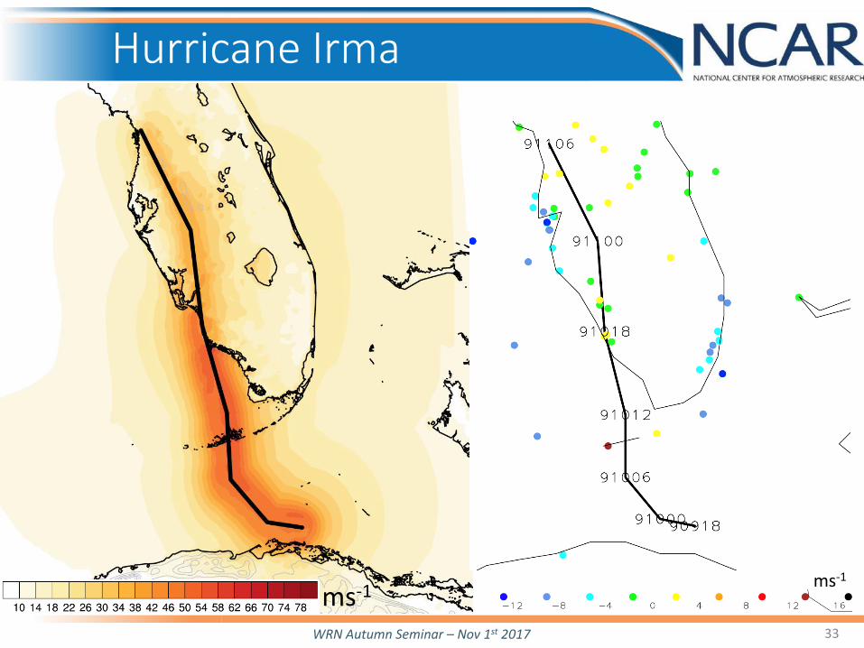
Hurricane Irma
ms-1 ms-1

WRN Autumn Seminar – Nov 1st 2017 34
Reconstructing older events
Typhoon Ellen (1983): Data: Vmax, lat, lon: IBTrACS. Rmax: Hong Kong radar. Constant 35km. R34: Hong Kong barogram. Set to 150km at landfall, then decrease following wind decay

WRN Autumn Seminar – Nov 1st 2017 35
Ellen’s Footprint at 78m
Unique view of risk to high rise structures.
ms-1

WRN Autumn Seminar – Nov 1st 2017 36
Application to Hazard Risk
10% annual wind speed (ms-1)
• Combining with TC risk modeling to produce new views of global wind risk.
• Particularly valuable in regions of complex terrain.

WRN Autumn Seminar – Nov 1st 2017
• A globally-consistent topography-aware historical footprint dataset.
• New views of historical events. • Dataset version 1.0.
37
Summary