
FLUVIAL SEDIMENTOLOGY VII - download.e-bookshelf.de...Fluvial processes and forms 3 Origin of...
30
FLUVIAL SEDIMENTOLOGY VII
Transcript of FLUVIAL SEDIMENTOLOGY VII - download.e-bookshelf.de...Fluvial processes and forms 3 Origin of...

FLUVIAL SEDIMENTOLOGY VII
FSA01 11/30/2004 02:17PM Page i

Other publications of the InternationalAssociation of Sedimentologists
SPECIAL PUBLICATIONS
34 Clay Mineral Cements in SandstonesEdited by R.H. Worden and S. Morad2003, 512 pages, 246 illustrations
33 Precambrian Sedimentary EnvironmentsA Modern Approach to Ancient DepositionalSystemsEdited by W. Altermann and P.L. Corcoran2002, 464 pages, 194 illustrations
32 Flood and Megaflood Processes and DepositsRecent and Ancient ExamplesEdited by I.P. Martini, V.R. Baker and G. Garzón2002, 320 pages, 281 illustrations
31 Particulate Gravity CurrentsEdited by W.D. McCaffrey, B.C. Kneller and J. Peakall2001, 320 pages, 222 illustrations
30 Volcaniclastic Sedimentation in LacustrineSettingsEdited by J.D.L. White and N.R. Riggs2001, 312 pages, 155 illustrations
29 Quartz Cementation in SandstonesEdited by R.H. Worden and S. Morad2000, 352 pages, 231 illustrations
28 Fluvial Sedimentology VIEdited by N.D. Smith and J. Rogers1999, 328 pages, 280 illustrations
27 Palaeoweathering, Palaeosurfaces andRelated Continental DepositsEdited by M. Thiry and R. Simon Coinçon1999, 408 pages, 238 illustrations
26 Carbonate Cementation in SandstonesEdited by S. Morad1998, 576 pages, 297 illustrations
25 Reefs and Carbonate Platforms in the Pacificand Indian OceansEdited by G.F. Camoin and P.J. Davies1998, 336 pages, 170 illustrations
24 Tidal Signatures in Modern and AncientSedimentsEdited by B.W. Flemming and A. Bartholomä1995, 368 pages, 259 illustrations
23 Carbonate Mud-moundsTheir Origin and EvolutionEdited by C.L.V. Monty, D.W.J. Bosence, P.H. Bridges and B.R. Pratt1995, 543 pages, 330 illustrations
19 Orbital Forcing and Cyclic SequencesEdited by P.L. de Boer and D.G. Smith1994, 571 pages, 320 illustrations
16 Aeolian SedimentsAncient and ModernEdited by K. Pye and N. Lancaster1993, 175 pages, 116 illustrations
3 The Seaward Margin of Belize Barrier andAtoll ReefsEdited by N.P. James and R.N. Ginsburg1980, 203 pages, 110 illustrations
1 Pelagic Sediments on Land and Under theSeaEdited by K.J. Hsu and H.C. Jenkyns1975, 448 pages, 200 illustrations
REPRINT SERIES
4 Sandstone Diagenesis: Recent and AncientEdited by Stuart D. Burley and Richard H. Worden2003, 648 pages, 223 illustrations
3 Deep-water Turbidite SystemsEdited by D.A.V. Stow1992, 479 pages, 278 illustrations
2 CalcretesEdited by V.P. Wright and M.E. Tucker1991, 360 pages, 190 illustrations
FSA01 11/30/2004 02:17PM Page ii

SPECIAL PUBLICATION NUMBER 35 OF THE INTERNATIONALASSOCIATION OF SEDIMENTOLOGISTS
Fluvial Sedimentology VII
EDITED BY
Michael D. Blum, Susan B. Marriott and Suzanne F. Leclair
SERIES EDITOR
Ian JarvisSchool of Earth Sciences and Geography
Centre for Earth and Environmental Science ResearchKingston University
Penrhyn RoadKingston-upon-Thames KT1 2EE
UK
FSA01 11/30/2004 02:17PM Page iii
© 2005 International Association of Sedimentologistsand published for them byBlackwell Publishing Ltd
BLACKWELL PUBLISHING350 Main Street, Malden, MA 02148-5020, USA108 Cowley Road, Oxford OX4 1JF, UK550 Swanston Street, Carlton, Victoria 3053, Australia
The right of M.D. Blum, S.B. Marriott and S.F. Leclair to be identified as the Authors of the Editorial Material in this Work has been asserted in accordance with the UK Copyright, Designs, and Patents Act 1988.
All rights reserved. No part of this publication may be reproduced, stored in a retrieval system, or transmitted, in any form or by any means, electronic, mechanical, photocopying, recording or otherwise, except as permitted by the UK Copyright, Designs, and Patents Act 1988, without the prior permission of the publisher.
First published 2005 by Blackwell Publishing Ltd
Library of Congress Cataloging-in-Publication Data
Fluvial sedimentology VII / edited by Michael D. Blum, Susan B. Marriott, Suzanne F. Leclair.p. cm. a (Special publication number 35 of the International Association
of Sedimentologists)Includes bibliographical references and index.ISBN 1-4051-2651-5 (pbk. : alk. paper)
1. SedimentologyaCongresses. 2. River sedimentsaCongresses.I. Title: Fluvial sedimentology 7. II. Blum, Mike D.III. Marriott, Susan B. IV. Leclair, Suzanne F.V. Series: Special publication . . . of the International Association of Sedimentologists; no. 35.
QE471.2.F57 2005552.5adc22
2004003106
A catalogue record for this title is available from the British Library.
Set in 9/111/2pt Meliorby Graphicraft Limited, Hong KongPrinted and bound in the United Kingdomby TJ International Ltd, Padstow, Cornwall.
The publisher’s policy is to use permanent paper from mills that operate a sustainable forestry policy, and which has been manufactured from pulp processed using acid-free and elementary chlorine-free practices. Furthermore, the publisher ensures that the text paper and cover board used have met acceptable environmental accreditation standards.
For further information onBlackwell Publishing, visit our website:www.blackwellpublishing.com
FSA01 11/30/2004 02:17PM Page iv

Contents
135 Braided gravel-bed rivers with a limitedwidth: preliminary results of a hydraulicmodel studyC. Marti and G.R. Bezzola
145 The morphology and facies of sandybraided rivers: some considerations of scale invarianceG.H. Sambrook Smith, P.J. Ashworth, J.L. Best, J. Woodward and C.J. Simpson
159 Application of laser diffraction grain-sizeanalysis to reveal depositional processes intidally influenced systemsP. Siiro, M.E. Räsänen, M.K. Gingras, C.R.Harris, G. Irion, S.G. Pemberton and A. Ranzi
181 Sedimentology and avulsion patterns of the anabranching Baghmati River in theHimalayan foreland basin, IndiaR. Sinha, M.R. Gibling, V. Jain and S.K. Tandon
197 Estimating bedload in sand-bed channelsusing bottom tracking from an acousticDoppler profilerP. Villard, M. Church and R. Kostaschuk
Experimental and numerical modelling
213 The morphological and stratigraphicaleffects of base-level change: a review ofexperimental studiesF.G. Ethridge, D. Germanoski, S.A. Schummand L.J. Wood
243 A mass-balance framework for quantifyingdownstream changes in fluvial architectureN. Strong, B. Sheets, T. Hickson and C. Paola
vii Preface
Fluvial processes and forms
3 Origin of anastomosis in the upperColumbia River, British Columbia, Canada D. Abbado, R. Slingerland and N.D. Smith
17 Review of Amazonian depositional systemsA.W. Archer
41 Kinematics, topology and significance ofdune-related macroturbulence: someobservations from the laboratory and fieldJ. Best
61 Derivation of annual reach-scale sedimenttransfers in the River Coquet,Northumberland, UKI.C. Fuller, A.R.G. Large, G.L. Heritage, D.J.Milan and M.E. Charlton
75 Dune-phase fluvial transport anddeposition model of gravelly sandM.G. Kleinhans
99 Morphology and fluvio-aeolian interaction of the tropical latitude, ephemeral braided-river dominated Koigab Fan, north-west NamibiaC.B.E. Krapf, I.G. Stanistreet and H. Stollhofen
121 A qualitative analysis of the distribution of bed-surface elevation and thecharacteristics of associated deposits for subaqueous dunesS.F. Leclair and A. Blom
FSA01 11/30/2004 02:17PM Page v

vi Contents
Quaternary fluvial systems
257 The linkage between alluvial and coevalnearshore marine successions: evidencefrom the Late Quaternary record of the PoRiver Plain, ItalyA. Amorosi and M.L. Colalongo
277 Depositional processes in latest Pleistoceneand Holocene ephemeral streams of theMain Ethiopian Rift (Ethiopia)M. Benvenuti, S. Carnicelli, G. Ferrari andM. Sagri
295 Fluvio-deltaic floodbasin depositsrecording differential subsidence within acoastal prism (central Rhine–Meuse delta,The Netherlands)K.M. Cohen, M.J.P. Gouw and J.P. Holten
321 Geomorphology and internal architecture ofthe ancestral Burdekin River across theGreat Barrier Reef shelf, north-eastAustraliaC.R. Fielding, J.D. Trueman, G.R. Dickensand M. Page
349 Quaternary alluvial stratigraphicaldevelopment in a desert setting: a casestudy from the Luni River basin, Thar Desert of western IndiaM. Jain, S.K. Tandon, A.K. Singhvi, S. Mishra and S.C. Bhatt
373 The Middle Valley of the Tiber River,central Italy: Plio-Pleistocene fluvial andcoastal sedimentation, extensionaltectonics and volcanismM. Mancini and G.P. Cavinato
Pre-Quaternary fluvial systems
399 Transport modes and grain-size patterns influvial basinsP.F. Friend and W.B. Dade
409 Gulf of Mexico Basin depositional record ofCenozoic North American drainage basinevolutionW.E. Galloway
425 Fluvial–estuarine transitions in fluvial-dominated successions: examples from theLower Pennsylvanian of the CentralAppalachian BasinS.F. Greb and R.L. Martino
453 Palaeogeography and fluvial to estuarinearchitecture of the Dakota Formation(Cretaceous, Albian), eastern Nebraska,USAR.M. Joeckel, G.A. Ludvigson, B.J. Witzke,E.P. Kvale, P.L. Phillips, R.L. Brenner, S.G.Thomas and L.M. Howard
481 Improved understanding of fluvialarchitecture using three-dimensionalgeological models: a case study of theWestphalian A Silkstone Rock, PennineBasin, UKK.J. Keogh, J.H. Rippon, D. Hodgetts, J.A. Howell and S.S. Flint
493 Changing alluvial style in response tochanging accommodation rate in a proximalforeland basin setting: Upper CretaceousDunvegan Formation, north-east BritishColumbia, CanadaM.P. Lumsdon-West and A.G. Plint
517 A new evaluation of fining upwardsequences in a mud-rock dominatedsuccession of the Lower Old Red Sandstoneof South Wales, UKS.B. Marriott, V.P. Wright and B.P.J. Williams
531 Reservoir scale sequence stratigraphy forhydrocarbon production and development:Tarbat–Ipundu Field, south-westQueensland, AustraliaR.S. Root, S.C. Lang and D. Harrison
557 Recognition of a floodplain within braiddelta deposits of the Oligocene MinatoFormation, north-east Japan: fine depositscorrelated with transgressionK. Yagishita and O. Takano
569 Index
FSA01 11/30/2004 02:17PM Page vi

Preface
the beginning of the twenty-first century, andincluded the following:1 General topical sessions
• flow, sediment transport and bedformdynamics
• fluvial channel systems—modern andancient
• fluvial overbank systems—modern andancient
• sequence stratigraphy of alluvial successions• fluvial systems and economic resources• river management
2 Special interest symposia• alluvial architecture• dryland rivers—process and products• deposits in mud-dominated rivers• alluvial and tectonic system interactions• fluvial system response to climate change
through time• alluvial responses to accommodation
changes• response of near-coastal fluvial systems to
sea-level change• fluvial reservoirs• fluvial–estuarine transitions• the Late Quaternary Rhine–Meuse systemA similar topical and geographical diversity is
reflected in the 29 papers included in this SpecialPublication. In the first group, one set of papersfocuses on flow, sediment transport and bedformdynamics. J. Best presents a series of laboratoryand field observations on dune-related macrotur-bulence. I. Fuller and others quantify reach-scalesediment transfers in the River Coquet, England.M. Kleinhans summarizes results of flume experi-ments coupled with empirical data from the Rhineto discuss dune-phase bedload transport and the importance of sorting processes. S. Leclair and A. Blom present results of flume experimentsdesigned to decipher controls on the probability
Papers in this IAS Special Publication are derivedfrom oral and poster presentations at the 7thInternational Conference on Fluvial Sedimento-logy (ICFS), held in Lincoln, Nebraska (USA),6–10 August 2001. The ICFS series was initiatedin Calgary, Alberta in 1977, has been held everyfour years, and has become a staple within theinternational fluvial sedimentology community.The 7th ICFS was attended by 289 professionalsand students from 28 countries, who repres-ented universities, government institutions andprivate enterprise. The next meeting in this series, the 8th ICFS, will be held in 2005 at Delft, The Netherlands, and will be hosted by Delft University of Technology (http://www.8thfluvconf.tudelft.nl/).
The 7th ICFS was hosted by the Department of Geosciences of the University of Nebraska-Lincoln, and, like its predecessors, operated without an umbrella provided by formal affilia-tion with professional scientific organizations.Indeed, the 7th ICFS could not have taken placewithout the generous sponsorship and logisticalsupport provided by the University of Nebraska,the hard work contributed by many University of Nebraska faculty and students, the efforts of the many conference field trip leaders, and thefinancial assistance provided by the InternationalAssociation of Sedimentologists, Society forSedimentary Geology, American Association ofPetroleum Geologists, Conoco Inc., ExxonMobilUpstream Research Co., Phillips Petroleum Com-pany, Schlumberger Reservoir Technologies andSTATOIL.
The 7th ICFS included four days of technicalsessions, with 175 oral presentations and 60posters, plus nine pre-, post- and mid-conferencefield trips. Conference themes reflected the topicaland geographical diversity of exciting researchbeing conducted by fluvial sedimentologists at
FSA01 11/30/2004 02:18PM Page vii

viii Preface
distribution of bed-surface elevations, and thestructure and texture of the associated deposits,under dune-forming conditions. C. Marti and P.Bezzola present early results of numerical andphysical modelling of Alpine streams, which aredesigned to assist redevelopment of more naturalbraided patterns in rivers that have beenartificially narrowed as a result of river trainingactivities. Last, P. Villard and others discuss themeasurement of bedload in sand-bed channelsusing an acoustic Doppler profiler, and the meritsof this technique relative to traditional mechanicalsamplers.
The second set within the first group focuses on the characteristics of modern fluvial landforms,environments and systems. D. Abbado and othersdescribe the role of high floodplain aggradationrates in promoting anastomosis along a reach of the Columbia River in British Columbia. A.Archer provides a very useful and extensivereview of the state of knowledge on Amazoniandepositional systems. C. Krapf and others describethe processes, characteristics and importance offluvial–aeolian interactions for the Koigab Fan in north-west Namibia. G. Sambrook Smith andothers discuss the spatial scale invariance of barshapes and scour depths in modern braidedrivers, as well as the difficulties of applying scaleinvariant concepts to older deposits owing to theimportance of temporal evolution and rates ofmigration of bar forms. P. Siiro and others uselaser diffraction analysis to compare the grain-sizedistributions of Cretaceous and the Miocene epi-continental embayment/seaway systems in Southand North America, so as to unravel the formationof sand–mud couplets within tidally influencedinclined heterolithic strata. Finally, R. Sinha andothers describe the sedimentological characteris-tics and avulsion history within an anabranchingreach of the Bahgmati River, India, which flowsfrom the Himalayan foothills into the rapidly sudsiding foreland.
A short second group focuses on physical ana-logue and numerical modelling. F. Ethridge andothers provide an overview of a generation ofexperimental studies at Colorado State Universityon the morphological and stratigraphical effects of base-level change. This is followed by N. Strongand others who present a new approach for the
quantification of downstream changes in alluvialarchitecture based on mass-balance considerations.
The third group includes papers that address theresponses of Quaternary fluvial systems to climatechange, active tectonics, and/or sea-level change.A. Amorosi and M. Colalongo discuss alluvial andcoeval nearshore marine successions of the PoRiver Plain, Italy, and consider some implicationsfor sequence-stratigraphy models. M. Benvenutiand others describe depositional processes, faciesand the latest Pleistocene to modern evolution of discontinuous ephemeral streams of the mainEthiopian rift. K. Cohen and others discuss howdetailed studies of fluvial–deltaic deposits of theRhine–Meuse delta, The Netherlands, record differential subsidence. C. Fielding and othersdescribe the response of the ancestral BurdekinRiver, north-east Australia, to sea-level fall, as itcut across the Great Barrier Reef Shelf. M. Jain andothers document the Quaternary stratigraphicaldevelopment of the Luni River system, in the TharDesert of western India, and the influences of tectonic activity and climate change over a varietyof time-scales. Finally, M. Mancini and G. Cavinatosummarize the Plio-Pleistocene evolution of theTiber River system, central Italy, in response toextensional tectonics, volcanism and climatechange.
The final group of papers addresses a variety of topics based on studies of pre-Quaternaryfluvial systems. The first paper by P. Friend andW.B. Dade presents a model for transport modesand grain-size patterns in fluvial basins. W.Galloway summarizes his conference keynoteaddress, and in doing so provides an overview ofCenozoic North American drainage basin evolu-tion, as recorded in the northern Gulf of Mexicobasin, offshore Texas and Louisiana, USA. S. Greband R. Martino describe fluvial–estuarine trans-itions in the Lower Pennsylvanian of the CentralAppalachian Basin, eastern USA. R.M. Joeckeland others present a detailed summary of fluvialto estuarine architecture and palaeogeography ofthe Cretaceous Dakota Formation from easternNebraska, USA. K. Keogh illustrates the utility ofthre-dimensional models of alluvial architecture,using the Westphalian A Silkstone Rock, PennineBasin, UK as a case study. M. Lumsdon and A.G.Plint discuss how changes in the rate of generation
FSA01 11/30/2004 02:18PM Page viii

Preface ix
of accommodation affects alluvial style in theUpper Cretaceous Dunvegan Formation, north-east British Columbia, Canada. S. Marriott andothers discuss fining upward sequences in a mud-rock dominated succession of the Lower Old RedSandstone of South Wales, UK, and suggest anenvironment of deposition similar to that of theChannel Country in central Australia, where bedload often consists of sand-sized mud aggre-gates. R.S. Root and others use a data set from theTarbat–Ipundu Field in south-west Queensland,Australia, to demonstrate how sequence strati-graphy can be applied at the hydrocarbon reser-voir scale. Finally, K. Yagishita and O. Takanodescribe floodplain strata and their sequence-stratigraphy significance within braid deltadeposits of the Oligocene Minato Formation,north-east Japan.
Such a diversity of papers requires a diversity ofexpertise to provide the critical review necessaryto bring them to publication form. Indeed, a largenumber of individuals, conference attendees andothers from the broader community served asreviewers for one or more papers submitted to this IAS Special Publication. These reviewers areJ. Abbott, J. Alexander, M. Allison, A. Amorosi, A. Archer, A. Aslan, P. Ashworth, W. Autin, J. Baas,M. Benvenuti, H. Berendsen, S. Bennett, M. Blum,M. Bourke, R. Brenner, J. Bridge, G. Browne,
P. Carling, M. Church, I. Cojan, J. Crabaugh, A.Czajka-Kaczka, R. Dalrymple, S. Davies-Vollum,K. Eriksson, K. Farrell, H. Feldman, M. Filgueira-Rivera, J. Friedmann, P. Friend, W. Galloway, P. Ghosh, M. Gibling, Steve Greb, M. Guccione, P. Heller, M. Hicks, J. Holbrook, P. Houben, J. Howell, P. Hudson, J. Isbell, C. James, M. Kleinhans, N. Lancaster, S. Lang, A. Large, J. Laronne, S. Leclair, M. Leeder, G. Lowey, D. Maddy, B. Makaske, S. Marriott, A. Mather, D. May, P. McCarthy, S. McClelland, D. Mohrig, G. Nadon, G. Nanson, C. Paola, F. Pazzaglia, J. Pederson, G. Plint, G. Postma, T. Rittenour, A. Roy, G. Sambrook Smith, G. Saunders, R. Sinha, R. Slingerland, N. Smith, R. Smith, H. Stollhofen, E. Straffin, J. Swenson, S. Tooth, T. Törnqvist, P. Villard, G. Weissmann, A. Wilbers,J. Woodward, C. Wooldridge, P. Wright, and V. Zlotnik. We owe them a debt of gratitude forthis valuable service.
MICHAEL BLUM
Baton Rouge, Louisiana, USA
SUSAN MARRIOTT
Bristol, United Kingdom
SUZANNE LECLAIR
New Orleans, Louisiana, USA
FSA01 11/30/2004 02:18PM Page ix

FSA01 11/30/2004 02:18PM Page x

Fluvial processes and forms
FSC01 11/30/2004 02:18PM Page 1

FSC01 11/30/2004 02:18PM Page 2
INTRODUCTION
Anastomosed rivers consist of two or more interconnected, coexisting channels that typic-ally enclose concave-upwards floodbasins. The channels are usually straight or slightly sinuous,but braided and meandering patterns are alsoknown. Thus, anastomosed rivers are differentfrom braided rivers because the latter containmultiple thalwegs enclosing convex bars within asingle channel (Makaske, 2001) whereas anasto-mosis defines a network of anabranched channels.Although the geomorphological characteristics ofanastomosed rivers have been recognized and
described (Smith & Putnam, 1980; Smith & Smith, 1980; Rust, 1981; Smith, 1983, 1986;Nanson et al., 1986; Schumann, 1989; Miller,1991; Knighton & Nanson, 1993; Smith et al.,1997, 1998; Makaske 1998, 2001), the origin ofanastomosis is still an unresolved matter (Nanson& Huang, 1999; Makaske 1998, 2001). Indeed,Makaske (1998) argued that understanding thecauses of anastomosis ‘is one of the major chal-lenges in current fluvial research’, and Nanson &Huang (1999) asserted that anabranching rivers(including anastomosed rivers) ‘remain the lastmajor category of alluvial systems to be describedand explained’.
Origin of anastomosis in the upper Columbia River, British Columbia, Canada
DIMITRI ABBADO*, RUDY SLINGERLAND*, 1
and NORMAN D. SMITH†*Department of Geosciences, Pennsylvania State University, 503 Deike Building,
University Park, PA 16802, USA (Email: [email protected]); and†Department of Geosciences, University of Nebraska, 214 Bessey Hall, PO Box 880340,
Lincoln NE 68588, USA
ABSTRACT
To understand the origin of anastomosis on the Columbia River betweenSpillimacheen and Golden, British Columbia, Canada, a geomorphological andsedimentological survey was undertaken during the summer flood of 2000. Onthe basis of these observations, the study reach can be divided into two sub-reaches: a highly anastomosed section with three to five channels, and a weaklyanastomosed section with one to two channels. The highly anastomosed reachoccurs immediately downstream from the Spillimacheen tributary and is characterized by a higher channel slope, a higher number of crevasse splays, alarger combined crevasse splay area, a wider valley and a coarser bedload.Higher rates of floodplain aggradation in the highly anastomosed reach are suggested by modern sediment budgets and radiocarbon dates. These geomor-phological and sedimentary associations are consistent with the hypothesis that anastomosis of the Columbia River is maintained by a dynamic equilibriumbetween the rates of channel creation and channel abandonment. Rising base-level, fine bedload and low bed-slope are not necessary immediate conditionsfor anastomosis of the Columbia River.
1Corresponding author.
Spec. Publs int. Ass. Sediment. (2005), 35, 3–15
FSC01 11/30/2004 02:18PM Page 3

4 D. Abbado, R. Slingerland and N.D. Smith
Three hypotheses exist for the origin of anasto-mosis. In the first, anastomosis is a consequence of frequent avulsions and slow abandonment ofearlier channels (see e.g. Makaske (2001) and refer-ences therein). According to this point of view, the fluvial system exists in a perpetual transitionstate consisting of multiple coexisting channels.Anastomosis is thus not a ‘graded’ state, but rathera by-product of the competition between channelcreation and abandonment. Makaske (2001), forexample, defined an anastomosed system as theproduct of a dynamic balance between frequentavulsions that create multiple channels and slowchannel abandonment. According to Makaske, theimmediate causes of the frequent avulsions are a rise in base-level, subsidence (Smith, 1983), andhigh rates of aggradation, whether of the channelbelt or within the channel. The immediate causeof slow abandonment is conjectured by Makaske(2001) to be low stream power, although few dataexist.
In the second hypothesis, anabranching andanastomosed rivers are thought to be an equilibriumform where channels are adjusted in geometry andhydraulic friction to just transmit the imposedwater and sediment discharges. In cases wheregradient cannot easily be increased to carry alarger sediment load, Nanson & Knighton (1996)and Nanson & Huang (1999) proposed that a shiftfrom single to multiple channels leads to anincrease in sediment transport rate per unit waterdischarge. Thus, like changes in slope and channelform, anastomosis is conjectured to be anothermechanism whereby a fluvial system can maintaingrade. Makaske (1998) challenged this idea, how-ever, arguing that the multichannel state of theupper Columbia River cannot be taken as aresponse of the system to maximize water and sediment throughput because, in spite of its anastomosed morphology, the bulk of its waterand sediment moves through a single channel.
The third hypothesis was put forward by Galayet al. (1984) from a study of the Columbia River.They postulated that ponding behind alluvial fansled to the formation of large lakes in the upperColumbia Valley. The lakes gradually were filledby river-dominated ‘bird’s-foot’ deltas of whichthe present anastomosed river system is a finalstage. This type is thought to result from con-temporaneous filling of shallow lakes and scour of
multiple channels in avulsion belts, so the anasto-mosis should be transitional and short-lived. Asubsequent palaeoenvironmental reconstructionof Columbia River deposits (Makaske, 1998) hasshown that its anastomosed channels are long-lived and not the result of delta growth into shallow lakes. Therefore this hypothesis will notbe considered further here.
The purpose of this paper is to describe thehydraulic and morphological properties of theanastomosed reach of the upper Columbia Riverin British Columbia, Canada, in order to assess theorigin of its anastomosis. The Columbia River near Golden, British Columbia is an appropriatefield site, being one of the best-known examples ofanastomosis (Locking, 1983; Smith, 1983; Makaske,1998, 2001; Adams, 1999; Machusick, 2000). Fur-thermore, hydrological and photographic recordsare available starting from the first half of the 1900s.
LOCATION AND GEOMORPHOLOGYOF THE STUDY AREA
The study reach is a section of the upper ColumbiaRiver near Golden, British Columbia, Canada (Fig. 1). The Columbia River starts at ColumbiaLake in southern British Columbia, approximately80 km south-east of the study reach, and flowsnorth-north-west in a 1–2-km-wide valley for adistance of 160 km along the Rocky MountainTrench before turning west and south-west. It consists of a single channel between ColumbiaLake and the town of Radium, an anastomosedreach between Radium and a kilometre upstreamof Golden, and a braided reach at Golden where itflows across the alluvial fan of a tributary, theKicking Horse River. Anastomosis is particularlyevident downstream of Spillimacheen, and thisreport concentrates on the 55-km reach betweenSpillimacheen and Golden. Access is provided byRoute 95 along the north-east side of the valley, bybridges at Nicholson, Parson and Spillimacheen,and by a railway right-of-way. The area lies withinthe Cassiar–Columbia Mountain physiographicregion and in the Interior Douglas-Fir biogeocli-matic zone (Farley, 1979). Mean annual precipita-tion varies between 40 and 50 cm yr−1, and meandaily temperature varies from −12 to 15°C inJanuary and July, respectively (Farley, 1979).
FSC01 11/30/2004 02:18PM Page 4

Anastomosis of the upper Columbia River, BC 5
Geomorphology and sedimentology of the studyreach
In the study reach, the Columbia River consists ofmultiple, relatively stable channel belts containinglow-sinuosity to straight, low-gradient, sand-bedchannels. Levees and crevasse splays of the channelbelts bound floodbasins containing shallow wet-lands and lakes. The channel belts show little lateral migration over their lifetimes, as indicatedby the absence of scroll bars on the modern floodplain and by the near vertical accretion ofchannel facies as seen in cores (see e.g. Makaske,1998, fig. 3.5). The channels are relatively straight,although smaller channels are slightly more sinu-ous. Thirty-seven tributaries enter along the reach,
forming alluvial fans that narrow the valley andact as local sediment sources. The two largest tributaries are the Spillimacheen River (drainagebasin of 1430 km2) and the Kicking Horse River(drainage basin of 1850 km2), which respectivelydefine the upstream and downstream limits of thestudy reach. The Spillimacheen River catchmentis a major sediment source for the study reach,contributing silt to fine gravel.
An important observation bearing on the origin of anastomosis is the number and locationof channels and their evolution through time.Vibracores show that anastomosed channeldeposits in the study reach are characteristically5–15 m thick, narrow, interconnected stringers of sand (Smith, 1983) that contain sandy crevasse-splay fringes. These facies are stacked vertically,indicating that the channels occupy the same valley location for durations of up to approx-imately 3000 yr or maybe even longer (Smith,1983; Makaske, 1998). Vertical aggradation ratherthan lateral accretion is the dominant sedimenta-tion pattern, a conclusion also supported by thevirtual absence of modern oxbow-lake and point-bar deposits. In one cross-valley stratigraphicalsection (Makaske, 1998), at least nine channelshave existed over the past 3000 yr. Of these, six came into existence and three went extinct,indicating the long-term existence of the anasto-mosed pattern and the episodic nature of channelcreation. There is also some indication that thelonger lasting channels are wider than 30–50 m(Makaske, 1998), possibly because smaller channelscan be occluded by log jams or have their gradientstrongly diminished by beaver dams.
The Columbia River sediment load consists of 59 to 82% suspended material (Makaske, 1998),or if wash load is also considered, 89% (Locking,1983). Locking’s sediment budget indicates that atthe end of the anastomosed reach near Nicholson(6 km upstream of Golden) the supply of suspendedload is much less than the transport capacity of the river. This decline in suspended load is evidence of a significant sediment sink in theanastomosed reach (Locking, 1983). Permanentsequestration of a portion of the bedload alsooccurs, with channel and crevasse splay storageroughly estimated by Smith to be, respectively,66% (Smith, 1986) and 10–20% (D.G. Smith, asreported in Makaske, 1998).
Edelweiss
TOWERPEAK
Spillimacheen River
Kicking Horse River
Golden
Golden
Nicholso
n
Nicholson
Moberly
McMurdo
McMurdo
Parson
Parson
Harrogate
Harrogate
Castredale
Castle dale
Brisco
Edgewater
Radium
Inverm
ere
Windermere
Lake (7
99m)
Columbia
Lake (8
09m)
Luxor
Spillimac h
een
Spillimac h
een
THE COLUMBIA RIVER
95
PURCELL MOUNTAINS
NORTH
0 5km
Horse Creek
Canyon Creek
BritishColumbia Aberta
Sask.
Manitoba
ColumbiaRiver
WesternCanada
SOLESBASIN
KOOTENAYRANGE
lake
levee
Fig. 1 Location of the study area. The Columbia Riverflows north-north-west between the Kootenay Range of the Rocky Mountains and the Purcell Mountains.Soles Basin, selected as a typical floodplain of the anastomosing reach, lies immediatelydownstream of the Spillimacheen River, an important tributary.
FSC01 11/30/2004 02:18PM Page 5

6 D. Abbado, R. Slingerland and N.D. Smith
Hydrology
Hydrographs for the Columbia River at Nicholson(1947–present) and the Spillimacheen River nearits mouth (1950–present) indicate that dischargesfor both are highly seasonal (Fig. 2). Minimum discharge for the Columbia occurs in February(average = 24 m3 s−1), and maximum dischargeoccurs in June and July (average = 321 m3 s−1), withoverbank discharge of 45 days per year on averageoccurring almost every year (Locking, 1983). Ourfield observations were taken during the year 2000flood, which was average in magnitude but shortin duration and somewhat delayed owing to coldweather in June (Fig. 2b & d). The peak flow
frequency distribution shows that the maximumpeak of 351 m3 s−1 registered at the Nicholson gaug-ing station during the year 2000 occurs on averageevery 1.2 yr (1-yr flood).
LONGITUDINAL VARIATIONS INANASTOMOSIS AND RELATEDFEATURES
To better understand the necessary conditionsthat give rise to anastomosis, the degree of ana-stomosis of the Columbia River was correlated withchannel gradient, crevasse splay distribution, valley width, alluvial fan area, and channel-bed
1950 1955 1960 1965 1970 1975 1980 1985 1990 1995 20000
200
400
600
800
year
Discharge of the Columbia River at Nicholson from 1947 to 2000
1 2 3 4 5 6 7 8 9 10 11 120
100
200
300
400
month
Average monthly discharge from 1947 to 1999Average monthly discharge in 2000
1950 1955 1960 1965 1970 1975 1980 1985 1990 1995 20000
50
100
150
200
250
300
year
Discharge of the Spillimacheen River at Spillimacheen from 1950 to 2000 (excluding 1985-94 due to lack of data)
1 2 3 4 5 6 7 8 9 10 11 120
50
100
150
month
Average monthly discharge from 1950 to 1999Average monthly discharge in 2000
(a)
(b)
(c)
(d)
m3
s-1m
3 s-1
m3
s-1m
3 s-1
Fig. 2 Discharge data for the rivers studied. (a) Discharge of the Columbia River at Nicholson1947–2000. (b) Average monthlydischarge of the Columbia over the interval 1947–1999 comparedwith year 2000 average monthlydischarge. (c) Discharge of the Spillimacheen River atSpillimacheen 1950–2000. (d) Average monthly discharge ofthe Spillimacheen over the interval1950–1999 compared with year2000 average monthly discharge.Year 2000 flood was average inmagnitude but of short duration anddelayed owing to cold weather inJune (Data from EnvironmentCanada, 2001).
FSC01 11/30/2004 02:18PM Page 6

Anastomosis of the upper Columbia River, BC 7
grain size. These parameters were measured during the summer of 2000 or were observed onaerial photographs taken in 1996 at high stage,when the discharge measured at Nicholson wasthe third highest of the previous 10 yr. Given the hydrological data available from Environ-ment Canada (formerly Water Survey of Canada)from 1947 to present, the 1996 peak discharge(506 m3 s−1) occurs on average every 3.3 yr (3-yrflood).
For our purposes, a channel belt is defined asactive, in contrast with non-active, dry, or aban-doned, if channels within it contain turbid wateron the 1996 aerial photograph, thereby implyingat least modest through-flow. Main channels are defined as those wider than 40 m; narrowerchannels are here termed secondary channels.Figure 3 shows a highly anastomosed section ofthe study reach where active/non-active channels
and crevasse splays are indicated, as well asdefinition sketches of alluvial fan area, splay areaand valley width.
Degree of anastomosis
To quantify the degree of anastomosis, the numberof active channels at each of 29 valley cross-sections was counted. The number of channels,used here as a measure of anastomosis, varies fromone to five with an average near two (Fig. 4a). Onthe basis of these differences, the study reach canbe divided into an upper highly anastomosed reach(three to five channels), a weakly anastomosedreach (one to three channels), a single channel anda lower braided reach. The braided reach occurs as the Columbia River crosses the alluvial fan ofthe Kicking Horse River and will not be discussedfurther here.
valley border
valle
y
wid
th
valle
y
w
idth
alluvial fanalluvial fan
crevasse splayarea crevasse splays
inactive channel active channels
active crevasse splay inactive crevasse splay
Fig. 3 Morphological elements ofthe river system. (Top) 1998 aerialphotograph of the Columbia Rivershowing active and inactivechannels and crevasse splays. (Bottom) Definition sketch showing how crevasse splay area, alluvial fan area, and valley width werecomputed. See Fig. 6 for location.
FSC01 11/30/2004 02:19PM Page 7
8 D. Abbado, R. Slingerland and N.D. Smith
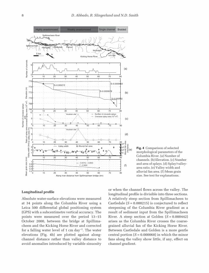
Longitudinal profile
Absolute water-surface elevations were measuredat 34 points along the Columbia River using aLeica 500 differential global positioning system(GPS) with a subcentimetre vertical accuracy. Thepoints were measured over the period 13–15October 2000, between the bridge at Spillima-cheen and the Kicking Horse River and correctedfor a falling water level of 1 cm day−1. The waterelevations (Fig. 4b) are plotted against along-channel distance rather than valley distance toavoid anomalies introduced by variable sinuosity
or when the channel flows across the valley. Thelongitudinal profile is divisible into three sections.A relatively steep section from Spillimacheen toCastledale (S = 0.000215) is conjectured to reflectsteepening of the Columbia River gradient as aresult of sediment input from the SpillimacheenRiver. A steep section at Golden (S = 0.000442)arises as the Columbia River crosses the coarse-grained alluvial fan of the Kicking Horse River.Between Castledale and Golden is a more gentlecentral portion (S = 0.000068) in which the minorfans along the valley show little, if any, effect onchannel gradient.
Highly anastomosed Weakly anastomosed Single channel Braided
HarrogateSpillimacheen
Castledale Parson
Nicholson
GOLDEN
Spillimacheen River
5 km
10
0
123 Valley width Alluvial fan area
5
10 20 30 40 50 60 70 80110
0 10 20 30 40 50 60 70 800.20.40.60.8
1
r2 = 0.3609y = −0.0074x + 0.8503
Mea
n gr
ain
size
(m
m)
0 10 20 30 40 50 60 70 800
5
Num
ber
of c
hann
els
766
768
770
772
774
776
Ele
vatio
n (m
)
Along river distance from Spillimacheen bridge (km)
102
104
103
Allu
vial
fan
area
(
hect
ares
)
Val
ley
wid
th (
km)
(a)
(b)
(c)
(d)
(e)
(f)
S=0.000215
S=0.0000678
S=0.0000902
S=0.000442
0 10 20 30 40 50 60 70 80
10 200 30 40 50 60 70 80
20 300 10 40 50 60 70 80
Rat
io o
f spl
ay a
rea
to v
alle
y ar
ea (
%)
10
0
5
Num
ber
of c
reva
sse
spla
ys
crev
asse
spl
ay a
rea
(105
m2 )
and
Number of crevasse splays Crevasse splay area (105 m5)
Avulsion site
Avulsion site
Kicking Horse RiverN
Fig. 4 Comparison of selectedmorphological parameters of theColumbia River. (a) Number ofchannels. (b) Elevation. (c) Numberand area of splays. (d) Splay/valley-area ratio. (e) Valley width andalluvial fan area. (f ) Mean grainsize. See text for explanations.
FSC01 11/30/2004 02:19PM Page 8

Anastomosis of the upper Columbia River, BC 9
Distribution of active crevasse splays
The study reach was divided into 29 cross-valleyswaths, each 2 km wide, in which the numbers of active crevasse splays and their total surfaceareas were determined. A crevasse splay was con-sidered to be active if turbid water was flowingacross its surface in the 1996 aerial photographs.The number of active crevasse splays and totalcrevasse splay areas are both relatively high in theupper 12 km of the study reach (Fig. 4c). Figure 4dshows the percentage of the valley floor coveredby active crevasse splays. There are 12 activecrevasse splays in the upper 18 km and only sixcrevasse splays along the remaining reach. Thearea covered by active splays decreases monoton-ically with distance, the exception being an activeavulsion site at kilometre 37. At this site, an ongoing avulsion blankets the whole floodbasinwith sediment, and small levees have formed since1960 (Adams, 1999). The study reach thereforecan be divided into two sections: an upstreamreach with a high number of crevasse splays; and adownstream reach with a low number of crevassesplays.
Valley width
Valley width is potentially an important parameterin determining anastomosis because it defines themaximum available space in which channel beltscan form. Variation in valley width is controlledby prograding alluvial fans from side tributaries.Measurements from aerial photographs of valleywidth and alluvial fan area (Fig. 4e) show littlecorrelation with anastomosis.
Bed material grain size
Bed material was sampled during high stage on 24 June and 6 July 2000 from the mouth of theSpillimacheen River to 5 km upstream of the townof Nicholson. Twenty-five samples were collectedalong the main thalweg using a bucket sampler(height 15 cm, diameter 10 cm) with three re-plicates each to capture cross-channel variability.Mean grain size was computed using a self-constructed rapid sediment analyser to obtain amean fall velocity that was then converted to
mean particle diameter using the relationship ofDietrich (1982).
Mean grain size shows considerable scatter (Fig. 4f ), probably owing to variations in texture atthe crest and troughs of dunes and the occasionalintroduction of coarse material from tributaries.Nevertheless, the bed material shows a statistic-ally significant fining downstream in the studyreach from 1.4–2.2 mm upstream to 0.5–1.1 mmdownstream.
Interpretation
The above data indicate that the study reach of the Columbia River (excluding the braided sectionand single-channel reach) can be divided into twosubreaches, a 17-km long, highly anastomosedreach with three to five channels starting immedi-ately below the confluence with the SpillimacheenRiver, and a 38-km long, weakly anastomosedreach containing one to three channels. Thehighly anastomosed reach is characterized by arelatively steep channel slope, a higher number ofcrevasse splays, a higher total crevasse splay area,a higher splay-area/valley-area ratio and coarserbed material (Table 1). These are particularlyinteresting observations because previous studieshave concluded that low gradients and fine grainsizes are necessary conditions for anastomosis (cf.Makaske, 2001). Previous studies also conjecturedthat rising base-level is a necessary immediatecondition for anastomosis (Smith & Smith, 1980),but that is not supported by these data either.
The intensity of crevasse splay activity is inter-preted to indicate that alluviation rates are higherin the upstream, highly anastomosed reach. Testingthis interpretation with actual measured aggrada-tion rates is difficult, however. The spatially averaged sedimentation rate during the 1982 floodcycle for the entire reach from Spillimacheen toNicholson was 3.7 mm yr−1 (Locking, 1983). Thisprobably is an overestimation of the long-termaverage because it is based on the 1982 flood,which was well above average. A detailed sedi-ment budget and geomorphological study of afloodbasin in the highly anastomosed reach (Fig. 1, Soles Basin) during the year 2000 flood(Abbado, 2001) shows that it is being activelyfilled at a rate of 2.2 mm yr−1 by a combination of
FSC01 11/30/2004 02:19PM Page 9

10 D. Abbado, R. Slingerland and N.D. Smith
short-lived crevasse splays, intrafloodbasin chan-nels and settling of grains in temporary lakes. Thisestimate was obtained by simultaneously measur-ing the sediment flux into and out of the basinthrough crevasses and over levee tops during the2000 flood. This must be considered a minimumbecause the flood of 2000 was shorter in durationthan the average flood (Fig. 2b) and only suspendedload was measured. In contrast, 16 km furtherdown the study reach, an average aggradation rateof 1.7 mm yr−1 was obtained using a radiocarbondate of 4500 cal. yr BP from Scirpus lacustrisnuts buried 7.9 m in a floodbasin (Makaske, 1998).Although the data are inconclusive, they are atleast consistent with the conjecture that aggrada-tion rates are higher upstream in the more ana-stomosed reach. Also consistent is the relativelysteep slope observable in the longitudinal waterprofile, which can be interpreted as a wedge ofsediments prograding downstream as alluviationoccurs. Finally, as Robinson & Slingerland (1998)and Paola (2000) have argued, the downstream-fining itself is suggestive of preferential aggrada-tion in the upstream reach. Although upstreambed-armouring could produce a similar down-stream fining trend, it does not adequately explainthe present data, because at the time of samplingthe pavement appeared to be broken and the bedwas in general motion.
SEDIMENT TRANSPORT MODELLING
The observations presented so far do not discrimi-nate between the two hypotheses for the origin of anastomosis in the Columbia because bothhypotheses predict that the degree of anastomosiswill be correlated with excess sediment supply.
Here, the question arises whether the Columbiachannels are adjusted to maximize sedimenttransport rate, as suggested by Nanson & Huang(1999) and Huang & Nanson (2000). In traditionalequilibrium channel theory, a river adjusts its slope,geometry and roughness to convey the water sup-plied and sediment discharge. Nanson & Knighton(1996) and Nanson & Huang (1999) suggested thata river might also change its number of channelsto yield the same effect. Based on field observa-tions, they asserted that a reduction in total top-width causes a multichannel network to conveymore sediment per unit of total stream power, or,holding slope constant, per unit of discharge, thana single channel. Thus, if an original channel is100 m wide and, say, 3 m deep, three channels,each 25 m wide and carrying the same dischargeat the same slope, will carry more bedload becausea reduced width/depth ratio (W/D) is more con-ducive to water flow and sediment discharge.
The hypothesis to be tested here is that thehighly anastomosed reach of the Columbia Riveris adjusted in channel number and channel width/depth ratios to carry more sediment than a singlechannel, all other factors such as Manning’s n andcross-sectional shape being equal. To test thehypothesis an abstracted Columbia channel net-work was considered (Fig. 5) in which cumulativetop-width, depth and bed-slope are kept constantat 120 m, 3 m and 10−4, respectively, consistentwith values observed in the upstream portion of the study reach (Fig. 6 & Table 2). As Table 2shows, width/depth ratios (defined as top-widthdivided by the hydraulic depth; see footnote inTable 2) range from 45 to 8. In addition, the dis-tribution of channel widths is bimodal with theminimum occurring between 40 and 50 m. Thisminimum was used to separate the channels into
Table 1 Comparison between the upper and lower anastomosed reaches of the Columbia River in the study area.
Area ofNumber of crevasse Splay area/ Valley
Degree of Number of Slope crevasse splays valley area width Grain sizeReach anastomosis channels (cm km−−1) splays* (m2 km−−1) (%) (km) (mm)
Upper High 3–5 21.5 10 c. 60 000 3.3 1.4–2.2 0.5–1.1Lower Low 1–3 6.8 1 c. 500† 0.035 0.7–1.8 0.3–0.6
*Average number of crevasse splays per 10 km wide transverse swath.†Excluding avulsion site.
FSC01 11/30/2004 02:19PM Page 10

Anastomosis of the upper Columbia River, BC 11
two groups: main channels and secondary channels.Based on these data from the Columbia River, the abstracted model contains a single channel of W/D ≅ 20, which progressively bifurcates into second-order channels of W/D ≅ 20 and third-orderchannels of W/D ≅ 10. Interestingly, the observedwidth/depth ratios of main channels decrease
W/D~40
W/D~20
W/D~20
W/D~10W/D~10Fig. 5 (left) Generic model of an anastomosing riverwith width/depth (W/D) ratios typical of the Columbia.The W/D ratio progressively decreases with increasingnumber of channels.
Table 2 Width/depth ratios of cross-sections in the study reach.
Hydraulic CumulativeCross-section Line Top-width, W depth, D Number of top-widthlocation number* Date (m) (m)† W/D channels‡ (m)§ Source
Main channels¶ 1 May 2000 125.7 2.86 44 1 125.7 This study4 July 2000 125 2.9 43 2 143 This study5 May 2000 88.9 2.87 31 3 120 Filgueira-Rivera**6 May 2000 88 2.88 31 3 120 Filgueira-Rivera**8 July 2000 90 2.95 31 3 180 This study
11 May 2000 55 2.82 20 4 188 Filgueira-Rivera**12 June 1988 67.6 2.6 26 3 150 Adams, 199917 June 1988 84.5 2.94 29 4 160 Adams, 199920 July 1994 57.5 4.44 13 4 100 Makaske, 199822 May 2000 141 3.12 45 1 141 Filgueira-Rivera**23 May 2000 101.6 3.34 30 2 130 Filgueira-Rivera**
Secondary 2 May 2000 19 1.96 10 2 143 Filgueira-Rivera**channels 3 May 2000 18.7 2.23 8 2 143 This study
7 May 2000 23.2 2.07 11 3 120 Filgueira-Rivera**9 May 2000 13.7 2.25 6 3 180 Filgueira-Rivera**
10 May 2000 38 2.95 13 4 172 Filgueira-Rivera**13 June 1988 30.4 1.58 19 5 Unknown Adams, 199914 May 2000 38.9 2.9 13 5 Unknown Adams, 199915 May 2000 31 3.64 9 5 Unknown Filgueira-Rivera**16 May 2000 35 3.49 10 4 Unknown Filgueira-Rivera**18 June 1988 20.3 1.25 16 4 Unknown Adams, 199919 July 1994 22.5 1.84 12 4 100 Makaske, 199821 July 1994 22.5 2.1 11 4 100 Makaske, 199824 May 2000 21 2.27 9 3 Unknown Filgueira-Rivera**
*See Fig. 6 for locations.†D = hydraulic depth, i.e. channel cross-sectional area divided by its top-width.‡Number of channels equals the sum of main plus secondary channels along a cross-valley transect passing through theparticular channel cross-section.§This is the summed top-width of all channels in a valley-wide transect passing through this location.¶ Main channels are defined here as having a top width greater than 50 m; all other channels are called secondary channels.**Personal communication.
FSC01 11/30/2004 02:19PM Page 11

12 D. Abbado, R. Slingerland and N.D. Smith
with an increasing number of channels along any valley cross-section (Fig. 7), which could beinterpreted as consistent with the Nanson–Huangconjecture. In contrast, the ratio for secondarychannels increases. An additional important characteristic of secondary channels is that theirthalwegs sit at higher elevations compared withthe main channels and thus they are active onlyduring high stage.
Sediment transport through this abstracted sys-tem is calculated under uniform and steady flowconditions assuming channels of rectangularcross-sectional shape in which:
Q = VA (1)
where Q (m3 s−1) is water discharge, V (m s−1) is average velocity, and A (m2) is channel cross-sectional area. Velocity, V, is expressed by theChézy formula:
V = C√R��S� (2)
where R (m) is hydraulic radius, S is channelslope and C (m1/2/s) is the Chézy constant. Valuesfor R and C are given by:
R = A/(2D + W) (3)
C = (1/n)R1/6 (4)
in which D (m) is the water depth, W (m) is thechannel width and n is the Manning constant. Thesystem of equations (1)–(4) yields the followingfifth-order polynomial in D:
k3W 5D5 − 4D2 − 4WD − W 2 = 0 (5)
where k = √S/(nQ). For fixed Q, n, S and width,equation (5) can be solved for D, thereby yielding a specific width/depth ratio for that combina-tion of values. In the following computations Q = 270 m3 s−1, n = 0.026, and S = 0.0001, consist-ent with typical values for the Columbia River inthe study area.
Once the flow hydraulics are known, bedloadand suspended load sediment transport rates arecalculated by two methods: (i) the Bagnold (1977)bedload formula coupled with the Rouse (1937)
(r2 = 0.77)
(r2 = 0.32)
0
5
10
15
20
25
30
35
40
45
50
Main Channels
Secondary Channels
W/D
of C
hann
els
0 1 2 3 4 5
Number of Channels along a Valley Cross-Section
Fig. 7 Width/depth ratios of channels as a function ofnumber of channels passing flow through any valleycross-section. Main channels are defined as thosepossessing widths greater than 50 m.
Flow
Location of Fig. 3
Fig. 6 Aerial photograph collage ofthe highly anastomosed reach of theColumbia River. Measured cross-sections are indicated by a whiteline; W/D ratio in parentheses.
FSC01 11/30/2004 02:19PM Page 12

Anastomosis of the upper Columbia River, BC 13
suspended sediment formulation, and (ii) the Van Rijn functions for bedload and suspended load(Van Rijn, 1984a,b). These methods were selectedbecause they are appropriate for the grain sizesand slopes observed in the Columbia River, andbecause they compute both bedload and suspendedload.
Solutions of the above system of equations fortotal sediment transport rate indicate that totalsediment load is reduced as the flow is dividedinto additional channels (Table 3). Total transportrate decreases by approximately 11% and 21% for the Bagnold–Rouse and Van Rijn formulas,respectively. In particular, bedload transport rate, which is more important because it controlsin-channel alluviation, decreases by 16% and 22%,respectively. Water velocities decrease by 2%moving from one to two channels, and 5% movingfrom two to four channels.
In order to generalize these conclusions, it is possible to argue that bed roughness should be greater in the smaller channels because ofincreased vegetation and because bedform heightsthere are a greater proportion of the flow depth.This, however, would only further reduce thetotal sediment load in the multichannel reaches. It could be argued that the idealized model doesnot capture the greater sinuosity and slightlyhigher bed elevations of the secondary channels.To address these concerns the steady-state flowfield through the actual Columbia River networkin the highly anastomosed reach was computedusing FESWMS, a two-dimensional, finite ele-ment code for non-uniform free-surface flows.Channel geometries were traced from aerial
photographs and channel bed elevations wereobtained by GPS and cross-section surveys. Waterdepths and flow velocities at two valley cross-sections, one where the Columbia River consistsof a single channel and one where it consists ofthree channels, were used to recompute total sediment fluxes through the two cross-sections.Predicted sediment fluxes through the reach withthree channels were 25 times less than through thesingle channel, thus supporting the conclusionsreached from the idealized model.
DISCUSSION
The multiple channels of the Columbia do notappear to be adjusted in width, depth and numberto increase water velocity and sediment transportrates over that of a single channel. These resultsare interpreted to mean that the Nanson & Huang(1999) hypothesis does not apply to the particularcase of the Columbia River. This is not to say that the Nanson–Huang conjecture is everywhereinvalidated. In cases where the cumulative top-width of multiple channels is reduced relative to a single channel, sediment transport rates will be increased. In the Columbia, however, theobserved width/depth ratios and cumulative top-widths do not effect increases in sedimenttransport rates as the number of channels isincreased.
Rather, it would appear that anastomosis of the Columbia River is a consequence of frequentavulsions (i.e. crevassing) and slow abandonmentof earlier channels. High sediment flux from the
Table 3 Theoretical sediment transport magnitudes as a function of sediment transport formula and number ofchannels: Q ≈ 270 m3 s−1.
Water Total Total suspendedNumber of Width Depth velocity bedload flux load flux Total sediment
Formula channels (m) (m) W/D (m s−−1) (m3 s−−1) (m3 s−−1) load (m3 s−−1)
Bagnold and Rouse 1 120 2.94 40.8 0.78 0.0061 0.0161 0.02222 60 3.00 20 0.77 0.0058 0.0156 0.02144 30 3.11 9.6 0.74 0.0051 0.0147 0.0198
Van Rijn 1 120 2.94 40.8 0.78 0.0036 0.0336 0.03722 60 3.00 20 0.77 0.0033 0.0310 0.03434 30 3.11 9.6 0.74 0.0028 0.0264 0.0292
FSC01 11/30/2004 02:19PM Page 13

14 D. Abbado, R. Slingerland and N.D. Smith
Spillimacheen River has overloaded the Columbia,causing high in-channel alluviation rates. Thesehigh alluviation rates increase the probability oflevee overtopping as well as levee crevassing andcrevasse splay formation. Increasing crevassing,in turn, creates numerous new channels throughfloodbasins. The new channels, flowing generallycross-valley, are usually super-elevated comparedwith the main channel. For this reason they aremainly active during high stage, and are slowlyabandoned because of low flow velocities. Thus,long-lasting channels and complete avulsions ofthe main channel are tied to gradient advantages.The narrow valley means that cross-valley gradi-ent advantage rarely occurs and the main down-valley channels remain active for thousands ofyears. In contrast, secondary channels on averageare shorter lived. The number of channels active at any time is proportional to the rate of creation of new channels and to their average lifespan, and inversely proportional to their rate of aban-donment. If the rate magnitudes are comparableand relatively constant through time, then thenumber of active channels at any instant is alsorelatively constant, the exact number being fixedby the channel lifespan. It is in this sense thatanastomosis of the Columbia River is a dynamicequilibrium pattern.
It still remains for the reduction of width/depthratio of main channels as the number of channelsin a valley cross-section increases to be explained(Fig. 7). This probably reflects the fact that it is themain channels of the Columbia that transportmost of the bedload. The bed elevations of the sec-ondary channels are generally higher than the bedof the main channel, so more water than bedloadis siphoned off by secondary channels. The mainchannel must adjust to carry its bedload with lessdischarge, and does so by decreasing its width/depth ratio by an amount greater than would arisefrom the reduction in water discharge alone. Inthis restricted sense the Columbia main channelsare behaving as postulated by Nanson & Huang(1999).
This model of anastomosis is consistent withthe correspondence between degree of anasto-mosis and high slope. As shown by the sedimentrouting model, anastomosis induces a decrease insediment transport rates, which is manifested bydifferential deposition.
CONCLUSIONS
The anastomosed reach of the Columbia River canbe divided into highly anastomosed and weaklyanastomosed subreaches. The highly anastomosedreach occurs immediately downstream of the con-fluence with the high-sediment-load SpillimacheenRiver. The highly anastomosed reach is character-ized by a higher channel gradient, a greater numberof crevasse splays, a greater crevasse splay area,greater splay-area to valley-area ratio, and coarserchannel-bed grain size. Circumstantial evidenceindicates that aggradation rates are higher in thehighly anastomosed reach as well. A rising base-level downstream does not seem to be a necessaryimmediate condition for anastomosis.
Calculations using Bagnold, Rouse, and VanRijn sediment transport formulae show a decreasein sediment flux with increasing number of chan-nels, given typical Columbia channel geometries,bed-slope, and grain size. This is contrary to thepredictions of Nanson & Huang (1999), leading us to conclude that anastomosis of the ColumbiaRiver is maintained by a dynamic equilibriumbetween the rates of channel creation and channelabandonment.
ACKNOWLEDGEMENTS
This research was funded by the National ScienceFoundation under contract EAR 9811860 awardedto Rudy Slingerland and Norman D. Smith. Forassistance in the field we thank Ron and Jan vanVugt, Irvine Heintz, Matt Machusick, and espe-cially Manuel Filgueira-Rivera who also sharedhis cross-section data with us. The manuscriptwas greatly improved by the insightful commentsof reviewers G.C. Nanson and B. Makaske, towhom we are grateful.
REFERENCES
Abbado, D. (2001) The origin of anastomosis in theUpper Columbia River, British Columbia, Canada.Unpublished MSc Thesis, Department of Geosciences,The Pennsylvania State University, 86 pp.
Adams, P.N. (1999) The origin and characteristics of natural levees. Unpublished MSc Thesis, Department
FSC01 11/30/2004 02:19PM Page 14

Anastomosis of the upper Columbia River, BC 15
of Geosciences, The Pennsylvania State University, 95 pp.
Bagnold, R.A. (1977) Bed load transport by naturalrivers. Water Resour. Res., 13, 303–312.
Dietrich, W.E. (1982) Settling velocity of natural par-ticles. Water Resour. Res., 18, 1615–1626.
Farley, A.L. (1979) An Atlas of British Columbia: People,Environment, and Resource Use. University of BritishColumbia Press, Vancouver, 135 pp.
Galay, V.J., Tutt, D.B. and Kellerhals, R. (1984) Themeandering distributary channels of the upperColumbia River. In: River Meandering (Ed. C.M.Elliot), pp. 113–125. Proceedings of the ConferenceRiver ’83, New Orleans, Louisiana, October 24–26,1983, American Society of Civil Engineers, New York.
Huang, H.Q. and Nanson, G.C. (2000) Hydraulic geo-metry and maximum flow efficiency as products of theprinciple of least action. Earth Surf. Process. Landf.,25, 1–16.
Knighton, A.D. and Nanson, G.C. (1993) Anastomosisand the continuum of the channel pattern. Earth Surf.Process. Landf., 18, 613–625.
Locking, T. (1983) Hydrology and sediment transport in an anastomosing reach of the Upper ColumbiaRiver, B.C. Unpublished MSc Thesis, Department ofGeography, University of Calgary, Canada, 107 pp.
Machusick, M.D. (2000) The effect of floodbasin type on crevasse splay form. Unpublished BSc. Thesis,Department of Geosciences, The Pennsylvania StateUniversity, 55 pp.
Makaske, B. (1998) Anastomosing Rivers: Forms, Pro-cesses and Sediments. Nederlandse Geografische StudiesVol. 249, Koninklijk Nederlands AardrijkskundigGenootschap/Faculteit Ruimtelijke Wetenschappen,Universiteit Utrecht, Utrecht, 287 pp.
Makaske, B. (2001) Anastomosing rivers: a review oftheir classification, origin and sedimentary products.Earth Sci. Rev., 53, 149–196.
Miller, J.R. (1991) Development of anastomosing channels in south-central Indiana. Geomorphology, 4,221–229.
Nanson, G.C. and Huang, H.Q. (1999) Anabranchingrivers: divided efficiency leading to fluvial diversity.In: Varieties of Fluvial Form (Eds A. Miller and A.Gupta), pp. 477–494. Wiley, New York.
Nanson, G.C. and Knighton A.D. (1996) Anabranchingrivers: their cause, character and classification. EarthSurf. Process. Landf., 21, 217–239.
Nanson, G.C., Rust, B.R. and Taylor, G. (1986) Coexistentmud braids and anastomosing channels in an arid-zone river: Cooper Creek, Central Australia. Geology,14, 175–178.
Paola, C. (2000) Quantitative models of sedimentarybasin filling: Sedimentology, 47 (Suppl. 1), 121–178.
Rouse, H. (1937) Modern conceptions of mechanics of fluid turbulence. Trans. Am. Soc. Civ. Eng., 102,436–505.
Robinson, R.A.J. and Slingerland, R.L. (1998) Origin of fluvial grain-size trends in a foreland basin: thePocono Formation of the Central Appalachian Basin:J. Sediment. Res., A68, 473–486.
Rust, B.R. (1981) Sedimentation in an arid-zone ana-stomosing fluvial system: Cooper’s Creek, CentralAustralia. J. Sediment. Petrol., 51, 745–755.
Schumann, R.R. (1989) Morphology of Red Creek,Wyoming, an arid-region anastomosing channel system. Earth Surf. Process. Landf., 14, 277–288.
Smith, D.G. (1983) Anastomosed fluvial deposits: modern examples from Western Canada. In: Modernand Ancient Fluvial Systems (Eds J. Collinson and J. Lewin). Spec. Publs Int. Ass. Sediment., 6, 155–168.
Smith, D.G. (1986) Anastomosing river deposits, sedi-mentation rates and basin subsidence, MagdalenaRiver, northwestern Colombia, South America.Sediment. Geol., 46, 177–196.
Smith D.G. and Putnam, P.E. (1980) Anastomosed riverdeposits: modern and ancient examples in Alberta,Canada. Can. J. Earth Sci., 17, 1396–1406.
Smith, D.G. and Smith, N.D. (1980) Sedimentation inanastomosing river systems: examples from alluvialvalleys near Banff, Alberta. J. Sediment. Petrol., 50,157–164.
Smith, N.D., McCarty, T.S., Ellery, W.N., Merry, C.L. and Ruther, H. (1997) Avulsion and anastomosis inthe panhandle region of the Okavango Fan, Botswana.Geomorphology, 20, 49–65.
Smith, N.D., Slingerland, R.L., Perez-Arlucea, M. andMorozova, G.S. (1998) The 1870s avulsion of theSaskatchewan River. Can. J. Earth Sci., 35, 453–466.
Van Rijn, L.C. (1984a) Sediment transport, part I. Bedload transport. J. Hydraul. Eng., 110, 1431–1456.
Van Rijn, L.C. (1984b) Sediment transport, part II.Suspended load transport. J. Hydraul. Eng., 110,1613–1641.
FSC01 11/30/2004 02:19PM Page 15

FSC01 11/30/2004 02:19PM Page 16

Review of Amazonian depositional systems
ALLEN W. ARCHERDepartment of Geology, Kansas State University, Manhattan, KS 66506, USA
(Email: [email protected])
ABSTRACT
Many types of depositional system exist within the Amazon River basin andsurrounding areas. These areas provide a number of valuable analogues forlarge-scale and tropical palaeoriver systems. Only rarely, however, are suchimportant analogues invoked because of a lack of published information.Herein, major components are summarized among the fluvial, estuarine andcoastal depositional environments of the Amazon River basin. Of particularimportance in the Amazon system are the recurring depositional cyclicities thataffect sedimentation. In the upper reaches of the system, yearly water-levelfluctuations are related to seasonal variations in rainfall. In some areas thesefluctuations exceed 10 m. The resultant flooding of vast areas of rainforestgreatly affects sedimentation. In the lower reaches of the system, the dominantwater-level fluctuations are related to tides. Tidal ranges are as high as 6 m at themouth of the Amazon and tidal influences extend more than 800 km up-river.The result is a vast area of tidally influenced, freshwater environments, whichare a poorly documented, but important, depositional setting.
There is a variety of river types within the Amazonian system, and the depositional environments along each are greatly affected by their differences insediment load. Some rivers, which include the tributaries that drain the Andes,are rich in suspended sediment and have alluvial valleys containing featurestypical of meandering rivers, such as levees, floodplain lakes and nutrient-richfloodplains. Other rivers, with drainages entirely within extensive areas of rainforest, drain deeply weathered terrains with highly leached soils. Theserivers lack suspended sediment, but have small amounts of bedload, and do notproduce alluvial valleys or levees. From a sequence stratigraphy perspective,the differences among rivers have resulted in considerable variation of responseto glacioeustatic-induced sea-level fluctuations and the ensuing inland changesin base level. During low stands, the Amazon deeply incised its valley for thousands of kilometres inland from the present position of the mouth. Duringtransgression, rivers with a high sediment load vertically aggraded and keptpace with base-level rise. At the same time, the valleys of sediment-poor riversflooded and were transformed into river-mouth lakes. These flooded valleys arenot restricted to coast-proximal settings, but can be found at distances morethan 1000 km inland from the modern coast.
Sediment supply has also differentially affected coastal settings along theAtlantic north and south of the Amazon mouth. The plume of turbid Amazonianwater moves north-westward along the coast because of predominant winds and currents. The longshore drift of this sediment-rich plume has resulted in a low-slope, mud-dominated, prograding coast. South of the Amazon mouth, however,the lack of sediment influx has resulted in a complexly embayed erosional coast-line. This southern coast consists of sea cliffs and headlands comprised of Mesozoicand younger rocks, which separate numerous small-scale macrotidal estuaries.
Spec. Publs int. Ass. Sediment. (2005), 35, 17–39
FSC02 11/30/2004 02:19PM Page 17

18 A.W. Archer
INTRODUCTION
Amazon drainage basin
The Amazon River system comprises the largestriver system on Earth. As described by Sioli(1984), the large size of the Amazonian drainagebasin, which exceeds 7 × 10⁶ km2, and the equat-orial and tropical climate result in tremendousdischarge and a high density of tributaries. TheAmazon complex comprises the world’s largestfreshwater system and contains approximately20% of the global supply of freshwater (Oltman,1967). The relative discharge of the Amazon (Fig. 1) has been estimated to be five times that of the Congo River and twelve times that of theMississippi River (Gibbs, 1967a).
The slope of the Amazon drainage basin, east of the Andes Mountains, is exceedingly low. AtIquitos in Peru (Fig. 2), which is a straight-line distance of 2975 km from the Amazon mouth, theelevation of the river during low-water stage isabout 114 m above sea level. Following the actualcourse of the river the distance from the mouth to Iquitos is 3717 km, making this the longest navigable inland waterway in the world. AtManaus in Brazil, which is a straight-line dis-tance of about 1200 km from the mouth, the elevation above sea level is only about 15 m
and the average slope to the mouth is only about 2 cm km−1.
The Amazon drainage basin is situated betweentwo ancient crystalline massifs, the Guiana Shieldto the north and the Brazilian Shield to the south,with the western margin delineated by the Andes.The basin is elongate and is approximately 3000 kmin length in an east–west direction, about 300-kmwide in the eastern part and 600- to 800-km widein the western part. This basin contains a thicksequence of Palaeozoic, Mesozoic, and Cenozoicrocks ( Junk & Furch, 1985). It is the largest sedi-mentary basin in the world and is formed upon aTertiary plateau consisting of a subdued area ofhills and ridges, which are mostly less than 60 mabove sea level (Irion, 1984). The elevation ofmuch of the basin lies below 100 m (Fig. 2).
Sequence stratigraphy considerations
From a sequence stratigraphy standpoint, theAmazon depositional system, as defined by thedrainage basin and adjacent areas of the coast andcontinental shelf, is exceedingly complex. Duringthe last glaciation and lowering of sea level, theAmazon deeply incised its valley to a positionapproximately 2000 km upstream from the currentmouth (Tricart, 1977). At that time, sea level wasapproximately 100 m lower and sediment was
Fig. 1 Comparison of total discharge of the Mississippi, Congo, and Amazon rivers together with relative contributionfor the major Amazonian tributaries (adapted from Gibbs, 1967b). Only lower reaches of Mississippi and Congosystems are represented.
FSC02 11/30/2004 02:19PM Page 18

Amazonian depositional systems 19
carried through what is now a shelfal submarinecanyon and deposited in a deep-sea fan termed theAmazon cone (Milliman et al., 1975; Damuth,1977). The glacial-age sediments of this fan aredominated by arkosic sands (25 to 60% feldspar),which suggest the presence of significantly drierclimates on the Brazilian and Guiana shields during sea-level low stand (Damuth & Fairbridge,1970). Milliman et al. (1975), however, have ques-tioned such interpretations of dramatic climaticchange.
Portions of the modern coast exhibit both submergent and emergent conditions. In general,the coast south of the Amazon mouth is emergentand is characterized by rocky headlines andembayments. In contrast, the coast to the north ofthe mouth, because of the tremendous amounts of suspended mud, is a depositional coast. Thusthere are significant differences between these twocoastal areas.
Geological evolution of the Amazon drainage basin
Prior to the Cenozoic Era, neither the AndesMountains nor the Atlantic Ocean existed and thegeological development of these features greatly
influenced the subsequent development of theAmazon River system.
The Solimões and Amazon basins are Palaeozoicintracratonic basins bounded by Precambrianshields. The Purús Arch, a basement featurelocated west of Manaus (Fig. 2), separates thesetwo basins. The Foz do Amazonas Basin, alsoknown as the Marajó Basin, is a Mesozoic featureand is separated from the Amazon Basin by theGurupá Arch, which is east of the mouth of the Rio Xingu. This arch is a structural high in thebasement. The Foz do Amazonas Basin relates tothe Late Jurassic to Early Cretaceous reactivationof basement structures, caused by the rifting andsubsequent break-up of Gondwanaland.
The upper Amazon, to the west of Manaus,probably drained to the west prior to the uplift of the Andes. During the Miocene, the area to the east was a vast brackish basin, which changedslowly to a freshwater environment (Beurlen, 1970).Miocene deposition of coarse colluvial materialwithin the basin does not agree with present-day depositional conditions related to the denseforest cover. This suggests the former existence ofa drier, more seasonal climate and would haveoccurred when the river profile was graded to alower sea level.
Fig. 2 Relative topography and bathymetry of Amazon Basin and surrounding areas. Much of the basin is less than100 m above modern sea level. The dashed ‘zero line’ is used to measure the extent of the inland penetration of tidesand comparison of yearly fluvial flux. Locations of major cities, referred to in the text, are shown along the mainchannel of the Amazonian system. Topography/bathymetry data are from Smith & Sandwell (1997).
FSC02 11/30/2004 02:19PM Page 19

20 A.W. Archer
Types of Amazonian rivers
The rivers and tributaries within the Amazon system exhibit significant differences owing tovariations in sediment types and supply, vegeta-tion, and relief and geology of the drainage basins.Wallace (1853) provided a useful and widely ac-cepted river classification, subsequently popular-ized by Sioli (1950), based upon optical properties.The rivers include whitewater, which are lightcoloured and very turbid owing to high concentra-tions of suspended sediments, blackwater, whichlack inorganic suspended sediment but have asignificant concentration of humic compounds,and clearwater, which lack suspended materialsor humic compounds.
Whitewater rivers
This river type includes the Rio Amazonas and itstributaries, primarily the Rios Japurá, Putumayo,Napo, Marañón, Ucayali, and Madeira, whichdrain the Andes. The Madeira is the most easternof this series of whitewater rivers. The headwatersconsist of readily weathered volcanic and sedi-mentary rocks, yielding very high sediment loads(Dunne et al., 1998). The light colours in theserivers, which are commonly yellowish or brownishand not actually white, relate to high concentra-tions of dissolved ions and suspended sediment.Gibbs (1967a,b) estimated that these tributariescomprise only about 12% of the Amazon drainagebasin, but supply 86% of the dissolved ions and82% of the suspended sediment. More recent estimates suggest that 90 to 95% of the suspendedsediment is derived from the Andes (Meade et al.,1985; Meade, 1994).
Whitewater rivers are characterized by mean-dering channel patterns and the bank erosion produces an abundance of floating and partiallysubmerged trees and other types of terrestrialplant debris. The water is relatively rich in nutri-ents and supports the growth of floating herbace-ous vegetation (as both floating meadows andislands). Runoff draining the rainforest does nothave typical blackwater colours because organicsare adsorbed on to clay particles where they aresubsequently decomposed (Jordan, 1985). Erosionand scour along whitewater rivers, such as the RioAmazonas, can undercut banks and result in long
stretches of shoreline catastrophically slumpinginto the river. These phenomena, termed terrascaidas (fallen land), can be quite dramatic and theresultant waves have been known to overwhelmsmall boats (Sioli, 1975).
Floodplains include relict meanders, levees,back swamps and floodplain lakes. The floodplainassociated with whitewater rivers is termed várzea(Pires & Prance, 1985). Owing to high suspendedloads, rapid rates of vertical accretion have keptpace with base-level rise. Bedload of the RioAmazonas consists primarily of fine-grained sand.In some places there are small amounts of gravel,particularly near bedrock outcrops. Unlike manyriver systems, however, the average grain size and degree of sorting within the mainstem bedsediments is essentially constant along the 3300km reach between Iquitos and Belém (Nordin et al., 1980, 1981).
Blackwater rivers
The term blackwater is somewhat misleadingbecause the water within such rivers is actuallyrelatively clear. For the Rio Negro, Sioli (1967)compared the river water to slightly contaminateddistilled water and stated that the river water hasthe appearance of very weak tea. The low levels ofsuspended sediment, lack of dissolved nutrientsand acidic conditions prevent the growth of float-ing vegetation.
Sandy podzolic soils give rise to the blackwaterrivers; the colours come from humic acids leachedfrom leaf litter (Leenheer, 1980; Jordan, 1985). The high concentration of organics creates acidicconcentrations and the pH of blackwater rivers is commonly about 4. Although blackwater riverslack suspended sediments, they can have signific-ant amounts of sand-rich bedload. One result ofthe low pH is that these bedload sands are almostexclusively quartzose because less stable mineralgrains are readily dissolved (Leenheer & Santos,1980).
The combined effects of lack of alluviation and extensive plant stabilization result in thefloodplains of blackwater rivers not having levees,backswamps and floodplain lakes. Thus, riverbanksare more stable than in whitewater systems andthe influx of plant debris into the river is minimal.Areas of flooded forest are termed igapó (Pires &
FSC02 11/30/2004 02:19PM Page 20