Fluorspar Deposits of the Eagle Mountains Trans … · the Eagle Mountains Trans-Pecos Texas ... A...
107
Fluorspar Deposits of the Eagle Mountains Trans-Pecos Texas GEOLOGICAL SURVEY BULLETIN 987 A study of the geology and fluorspar deposits of the Eagle Mountains Hudspeth County, Texas OHIO GEOLOGICAL SURVEY -j UNITED STATES GOVERNMENT PRINTING OFFICE, WASHINGTON : 1953
Transcript of Fluorspar Deposits of the Eagle Mountains Trans … · the Eagle Mountains Trans-Pecos Texas ... A...

Fluorspar Deposits of the Eagle Mountains Trans-Pecos Texas
GEOLOGICAL SURVEY BULLETIN 987
A study of the geology and fluorspar deposits of the Eagle Mountains Hudspeth County, Texas
OHIO GEOLOGICAL SURVEY
-j UNITED STATES GOVERNMENT PRINTING OFFICE, WASHINGTON : 1953

5"
UNITED STATES DEPARTMENT OF THE INTERIOR
Douglas McKay, Secretary
GEOLOGICAL SURVEY
W. E. Wrather, Director
For sale by the Superintendent of Documents, U. S. Government Printing Office Washington 25, D. C.

CONTENTS. ______
Page-Abstract. _ _ ___i_________________-_---_-__-___.-----____._____--- 1Introduction ____________________-_-_----_--_-_____-__--_-_-_____-- 3
Location __________ _________---_--__'-_--__-__-------_______..-_ .3Previous geologic work_______________-__-_____--_____________-_ 4Field work and purpose of the investigations._____________________ 6Acknowledgments _______________-l-_-__---___--__-_______--__- 7
Geology.________---__---__-_-_..---------------------------------- 8Metamorphic .rocks ___________-_______-______-------________--- 13
Pre-Cambrian________._.--___-.__-______---_____-_________ 13Carrizo Mountain schist_---__-_.___-___-___________-_ 13
Sedimentary rocks______________________________________________ 14Permian (?)_______________________________________.!_______ 14
Wolfcamp (?) formation____-__________________________. 14Cretaceous____________-____----_-___-_----__-____-____-- 15
Lower Cretaceous..------------------------------.---- 15Yucca formation..---__--------_--------------.--- 15
_ Bluff Mesa formation. ____.______-________.._.___-- 16Cox sandstone._-_-----_--._-_-_._----_--__._-__-- 21Finlay limestone__-____--___-__-_-_-__-_-___-___- 22Kiamichi formation.__.-_..__--___-_______-________ 25Georgetown limestone..____________________________ 25
Upper Cretaceous.____________________________________ 27Graysoh formation......_____..__..____._-_________ 27,Buda limestone__________________________________ . 31Eagle Ford formation_______________________________ 32
Quaternary.. ___________:___________.___.__________________ 33Terrace deposits, younger.alluvium, and basin fill____ 33
Igneous rocks__________________________________________________ 34Extrusive rocks._____-_-__--___-__-._________-___-_-____-- 34
Lower rhyolitic series__________________________________ 35Trachyte porphyry____--___-_-..-_..--____._._..____-_ 3&
. Upper rhyolitic series.-_---_----_---__---_--_-____---_. 37Intrusive rocks.____-__-_----_--_____.___-_____._._____._. 37
Rhyolite sills------_----_-------_-----_-._--_.-_...---- 37Eagle Peak syenite. ___________________________________ 3SDiabase dikes._-____--------__-____-_-_______._-_---_. 38Late rhyolite dikes-___-_._--------._.__-__-___._._-_.._ 39'
Structure. ____________________________________________________ 39Folding. --------._.._..-_--_-----.._._.......-----_-----. . 40Faulting_ _-_______-____-_-_^._____-..______....._...____ 41
Devil Ridge thrust fault---_--------_.-----_..._------.- 41Northeast-trending faults._--_-________-_-_____....._.__ 42Spar Valley fault.__-------_--------.-------....-_----_ 42North-northwest-trending faults-________________________ 44East-trending normal faults._-_-_-_____--______-_.._.__. 46Late faults_______________________________'_________._ 47
Features caused by landslides.-------.._____________________ 48Geologic history._-____________-_--_-______-___________________ 50
VII
IV CONTENTS
Page IMineral deposits_____-_-_____-_____________________________________ 52 ./
Lead, zinc, copper, and silver___________________________________ 52 \Coal__________________________________________ 53Fluorspar__ _ -_-_-___-___________________________^__.________ 53 !
History and ownership_____________________________________ 55 <Mmeralogy-------_---_______________-_________________.__ 57 ,
Fluorite____________________________________________ 57,Quartz___.___________________________________________ 58 JCalcite and ankerite._____________________________ _____ 58Limoriite, hematite, and pyrite..------------------------ 58Smithsonite-______.___________________________________ 58
Origin and paragenesis________________..________________.___ 59 >JStructural and stratigraphic control of ore bodies._____----____ 61Description of workings.___________________________________ 62 A
Eagle Spring__._______________________________________ 62Deposit in sec. 27_________________________________ 63 *North ore body, Spar Valley._____-__-__-_____-_--__-___ 63South ore body, Spar Valley______-_-_-_-_---_-------_-.. 63Rhyolite viein, Spar Valley_____________-________--.-___ 63 ^,Shaft 4_.___________________________________._________ 63Other workingS-____._.__.__________-___._-_.__.____-___ 63 -
Description of deposits._____________________________________ 66Eagle Spring____________________._________________ 67 +Deposit in sec. 27_____________-___---_---_-_-_---_-_ 69Lucky Strike___-____-_____-_-___-------__--------_-_ 69North ore body, Spar Valley-___________________________ 70South ore body, Spar Valley__-_-_-------------_-------- 75 |lRhyolite viein, Spar Valley.______-_---_-_---_-------_-_ 76 ,Shaft 4____.__________________________________________ 78Tank Canyon claims--_--__-_-------_---------------_-_ 79Syphon Canyon claim_________-_-_-------------------- 79Deposits in sees. 37 and 48_-_-----------_-------------- 80 *Oak claim 4__________-__-___---------_-------------- 81Fox claim 4___..._._-------_------------------------ 8?Fox claims 1 and 3, and deposits in sec. 45 _____---_-_ 82Rocky Ridge deposits.________-__-_-----.-------------- "^Fox claims 9 and 10___--_--_-------------------_------ 90
Reserves.-.-..------------------------------------------- 90 ^Recommendations for prospecting...---_-----_-------------- 91 <
References_ _-__-------------.------_----_____-__-_______________ 93--------- _____-----_--------------- -- 97
I
^

Plate1. Geologic map of part of the Eagle Mountains, Hudspeth County,
Tex_________________________ - In pocket2. Fault and vein map of the Eagle Mountains fluorspar district In pocket3. Claim map, Eagle Mountains In pocket
V 4. A, Nodular limestone of the lower part of the Finlay limestone, north of Lucky Strike prospect; B, nodular limestone and interbedded shale of the upper part of the Georgetown limestone and the Carpenter lime stone, Carpenter Canyon_____________ Following page 26
** 5. A. Reef-limestone member of the Grayson formation, Carpenter Can yon ; B, volcanic breccia of the lower rhyolitic series overlain by the
A columnar-jointed flows of the upper rhyolitic series; 0, two high-grade JT fluorspar zones, Fox claim 10 Following page 26
6. A, Fluorspar from the North ore body, Spar Valley; B, Fluorsparfrom pit on Fox claim 1_______________ Following page 58
, 7. Geologic map and section, Eagle Spring fluorspar deposit In pocket * 8. Geologic map of Spar Valley and vicinity__ In pocket
9. Geologic map and section, Lucky Strike fluorspar deposit, Sec-* tion 26___________________________________ In pocket ,4 10. Geologic map of the Spar Valley fluorspar deposits In pocket
11. Structure sections, Spar Valley fluorspar deposits _ In pocket12. Geologic map, North ore body, Spar Valley fluorspar deposits__ In pocket13. Composite level map, North ore body, Spar Valley fluorspar de-
. posits__ _____________ ______ _ In pocket14. Structure sections, North ore body, Spar Valley fluorspar de-
^ posits_____________________________ _ In pocket15. Geologic map of Shaft 4 fluorspar deposit, Spar Valley area __ In pocket
**" 16. Geologic map of fluorspar deposits, Section 37 __1_ In pocket ^ 17. Geologic map and sections, Rocky Ridge fluorspar deposits- In pocket
Figure Page 1. Index map showing Eagle Mountains fluorspar area, Hudspeth County,
Tex_______________________________________ 3*' 2. Map showing area of present report and other areas in western trans-
Pecos Texas on which geologic maps and reports have been published-.. 5* 3. Two interpretations of the Spar Valley fault______________ 44 ^ 4. Map sh'owing location of fluorspar and copper deposits in sees. 37 and
48, block 68, T. 9 and vicinity______________________ 48 5. Plan and sections through drill holes, showing analyses of samples
from trenches and drill holes, Silver Eagle deposit___________ __ 54* 6. Composite level map shaft 2, Rhyolite vein, Spar Valley fluorspar
deposits _________________________________. 64* 7. Geological map of Fox claim 4 fluorspar deposit, Section 48______ 65^ 8. Geologic map of fluorspar deposit, Fox claims 1 and 3_________ 66
9. Geologic map of Section 27 fluorspar deposit_______________ 71
> TABLEy
TABLE 1. Rocks of the Eagle Mountains, Hudspeth County, Tex_____ 9
T
* ** ' ' t '

T
' T
?
»
"

FLUORSPAR DEPOSITS OF THE EAGLE MOUNTAINS, TRANS-PECOS TEXAS
By ELLIOT GILLERMAN
ABSTRACT
The Eagle Mountains are in the southeastern part of Hudspeth County, Tex., about 17 miles southwest of Van Horn and 100 miles southeast of El Paso, Tex. The fluorspar deposits are in the northern and northeastern parts of the moun tains, except for the Rocky Ridge deposits, which are near the center of the mountainous mass. A good all-weather road leads south from Allamoore on U. S. Highway 80 to the mine and mill at Spar Valley. ' With the exception of the Rocky Ridge deposits, all deposits can be reached by ranch roads from the main Spar Valley road.
Fluorspar was first found in the Eagle Mountains in 1919, but no development was undertaken until 1942. Since then, mining has been done at Eagle Spring and at the various deposits in Spar Valley. Many other deposits have been found in the area. About 12,000 tons of fluorspar had been shipped previous to January 1949, most of which came from the North ore body in Spar Valley. A mill was built near the deposits in 1945. With the exception of the Eagle Spring and Tank Canyon deposits, both of minor importance, the fluorspar deposits as of 1950 are all controlled by Texas Fluorspar Mines, Inc., of Van Horn, Tex.
Cretaceous sedimentary rocks, which crop out on the flanks of the mountains, are overlain by a thick series of Tertiary volcanics that make up much of the central part of the mountains. Low on the northeast side, the Cretaceous rocks are underlain by Permian ('?) limestones and the pre-Cambrian Carrizo Mountain schist. The Cretaceous sedimentary rocks range from the Yucca formation of Early Cretaceous (lower Trinity) age through the Eagle Ford formation of Late Cretaceous age. The rocks on the northeast side of the mountains dip southwest, and those on the southwest and west sides dip east-northeast and northeast. The axis of the large syncline thus formed roughly parallels the axis of the range. The igneous rocks occur within the trough of the syncline.
Both intrusive and extrusive rocks are present. The extrusive rocks have been separated into three divisions: the lower rhyolitic series, trachyte porphyry, and the upper rhyolitic series. Both rhyolitic series consist of flows, flow breccias, volcanic breccias, and tuffaceous sediments, all predominantly of rhyolitic com position, although tending toward andesite locally. These volcanics have been intruded by a small stock of syenite, named in this report the Eagle Peak syenite, which crops out in the central, higher parts of the mountains. Rhyolite sills have invaded the sedimentary rocks near the margin of the volcanics, and dia base aoid late rhyolite dikes have intruded both sedimentary and volcanic rocks.
Faults are common in the area, and six series of faults have been recognized. Thrusting from the southwest occurred both before and after the igenous ac tivity and the subsequent downwarping of the central part of the mountains.
2 FLUORSPAR DEPOSITS OF THE EAGLE MOUNTAINS, TEXAS
The early thrust faults were followed by high-angle normal and reverse faults that trend northeastward and cut the volcanics. Later normal and reverse faults trending northwestward, and faults with large horizontal displacements trending roughly eastward, also are present, in addition to very late faults trending in a general northwesterly direction.
Fluorspar occurs in the Eagle Mountains both as replacement deposits in limestone and as fissure veins, chiefly in rhyolite. Chief among the fissure veins are those occurring along the Rhyolite fault, the Wind Canyon fault, the vein at Shaft 4, and the veins on Fox claims 9 and 10. The most important replace ment deposits are in the Rocky Ridge area and in Spar Valley. At the North ore body in Spar Valley, the fluorine-bearing solutions replaced a series of sandy limestones in the upper beds of the lower part of the Finlay formation. Struc tural conditions limited the extent of the replaceable beds and consequently of the fluorspar mineralization.
The fluorine-bearing solutions represent a very late stage of the igneous ac tivity of the area. The large east-trending faults with their wide zones of gouge and breccia, typified by the Rhyolite and Wind Canyon faults, acted as the major channels for the solutions in their upward course. From these faults, the so lutions spread outward into other faults and fractures, chiefly those with a northeasterly trend, and into the adjoining limestones. The physical and chemical nature of the surrounding rock, as well as structural conditions af fecting the presence of openings in the rock, were the major controlling factors governing the size, extent, and position of the fluorspar deposits.
INTRODUCTION
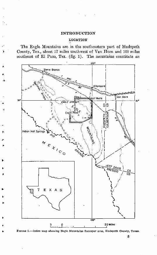
LOCATION
The Eagle Mountains are in the southeastern part of Hudspeth County, Tex., about 17 miles southwest of Van Horn and 100 miles southeast of El Paso, Tex. (fig. 1). The mountains constitute an
5 0i .... i
20 Miles
FIGDKB 1. Index map showing Eagle Mountains fluorspar area, Hudspeth County, Texas.
3

4 FLUORSPAR DEPOSITS OF THE EAGLE MOUNTAINS, TEXAS
isolated mass, covering approximately 125 sq miles, and rise about 3,000 ft above the level of the surrounding bolsons. The highest point,. Eagle Peak, is in the central part of the mountains at an altitude of 7,496 ft.
Narrow ridges and steep canyons characterize the area except along the lower courses of the major streams, where alluvial fill and remnants of pediments occupy wide valleys. Vegetation consists mainly of greasewood, creosote bush, yucca, cacti, and similar desert growth. Trees are scarce, and timber suitable for use in mining is lacking. The region is arid, having an annual rainfall of less than 10 inches. The climate is mild and suitable for mining operations throughout the year. Drainage toward the north and northeast is into Eagle Flat which is the western prong of Salt Flat, a large enclosed basin, and toward the southwest and west the region drains into the Rio Grande and its major tributary, Quitman Arroyo. Aside from the Rio Grande, all streams are intermittent and carry water only during the rainy season.
The fluorspar deposits, except for those in the Rocky Ridge areay occur in the northern and northeastern parts of the mountains (pis. 2 and 3). They can be divided conveniently into the Eagle Spring deposits, the Rocky Ridge and adjacent deposits, the deposits of the Spar Valley area, and numerous isolated deposits lying south and southeast of the Spar Valley area. A good all-weather road leads from Allamoore on U. S. Highway 80 and the Texas and Pacific Rail road, through Hot Wells on the Southern Pacific Railroad, to the mine and mill at the head of Spar Valley, a total distance of 15.5 miles. Ranch roads lead from this road to most of the other deposits. The Rocky Ridge area is inaccessible by automobile; a foot or horse trail, about 3 miles long, leads from the place where truck travel ends. This area can be reached by leaving the main Spar Valley road 2 miles southeast of the mill, and going west past the Eagle Mountain ranch house for 4 miles to the top of the divide, and then proceedingfor 3 miles on foot. It can be reackeJ also ky driving 23 mfe SOlltll"
east from Sierra Blanca on the Indian Hot Springs road to the Tid- well ranch house, and then proceeding northeast along a ranch roadto the Silver Eagle property where truck travel ends., A trail leads3 miles up Snowline Canyon to the deposits.
The Eagle Spring deposits are reached by driving 4.2 miles west
along the railroad from Hot Wells and then SOllth for 3.8 mileS. TllC
main workings are 2,00(Kft northwest Of Eagle Spring, a well-knownhistoric locality.
PREVIOUS GEOLOGIC WOEK
Although very little previous geologic work has been done in the Eagle Mountains, adjacent areas have received considerable attention

INTRODUCTION
32<
30 e
A N EJEL PASO1 El Paso
^ ̂ M MM MM ^^^^O
\ 1
W M E X
H I I H C D C T UU U D r L 1 n
)*v
V. __ 3X.X 5/ ISierra Bla°\j-rf e ?KJ
x «£s^4f \. S^
* ^\
/
0LIST OF PUBLISHED REPORTS O1. El Paso quadrangle2. Southern Guadalupe Mountains3. Sierra Diablo4. . Van Horn quadrangle5 Mnlnno MQypta ns
6. Northern Quitman Mountains7. Devil Ridge area8. Shatter area 9. Eagle Mountains
10 0i .... i i i
(this report) ,
50 Milesi i
1
C 0IT"1
i
1CULBERSON ',
'
nca 4
..Van Horn
1i
1./ V
/ ,'\ -^
\
\/ 'j EF F D A V 1 Sx~~~-
r\
I
^^~-~-
Marfa
PRESIDIO\
\ a8
^V Presidio
X
^
».
32°
31°
30°
29°
107° 106° 105° I04»
FIQORB 2. Map showing area included in present report (shaded) and other areas in western trans-Pecos Texas on which geologic maps and reports have been published.
both in the past and recently (fig. 2); and since 1935 areas to the north and west of the Eagle Mountains have been studied and mapped in great detail.
The earliest extensive geologic studies of trans-Pecos Texas were made by W. H. von Streeruwitz (1890, pp. 219-234; 1891, pp. 669-738; 1892, pp. 381-389; 1893, pp. 141-175) who first entered the area in 1878. In 1890 J. A. Taff (1891, pp. 714-738), as a member of von Streeru- witz's party, studied the stratigraphy of the region. His excellent re port includes a description of the Cretaceous rocks of the northern and northeastern parts of the Eagle Mountains and three measured sec-

6 FLUORSPAR DEPOSITS OF THE EAGLE MOUNTAINS, TEXAS
tions: one at Phinney's Ranch, which is about 1 mile southeast of the area included in the present report; one at Carpenter Spring; and one at Eagle Spring. The last two localities are within the mapped area (pl.l).
E. T. Durable (1895, pp. 375-388) published an account of the Cre taceous of western Texas and Coahuila, Mexico, in 1895, and in 1897 'and 1899 T. W. Stanton (1905, pp. 23-33) studied the stratigraphy of the area from the Eagle. Mountains west to the western foothills of the Malone and Quitman Mountains.
G. B. Richardson mapped the El Paso quadrangle (Richardson, 1909) and in 1904 made a reconnaissance study of the area to the north of the Eagle Mountains (1904). The Van Horn folio by Richardson (1914) contained a detailed account of the geology of the area imme diately to the northeast.
C. L. Baker (1927), in his study of the geology of trans-Pecos Texas, discussed the structure, stratigraphy and igneous geology on a regional basis. Although the geology of the Eagle Mountains is treated only in relation to the regional geology, his report has been the most informative publication on the geology of the Eagle Mountains.
In recent years detailed reports of areas nearby include those by C. C. Albritton, Jr. (1938, pp. 1747-1806) on the Malone Mountains, J. F. Smith, Jr. (1940, pp. 1747-1806) on the Devil Ridge area, and R. M. Huffington (1943, pp. 987-1048) on the northern Quitman Mountains. C. P. Ross (1943, pp. 45-125) studied and mapped the geology and ore deposits of the Shafter district. Preliminary maps of the areas just to the north of the Eagle Mountains' have been published by P. B. King and J. B. Knight (1944) and by P. B. King and H-. C. Fountain (1944). The locations of these areas of detailed study are shown on figure 2. A recently published report by King (1948) includes the area covered by the second of the preliminary maps mentioned above.
The only recent geologic publications on areas within the Eagle Mountains are Smith's (1941, pp. 70-79) report on the Eagle Spring area, Evans' (1943; 1946, pp. 227-238) reports on the fluorspar de posits of the Eagle Mountains, and Gillerman's (1948, pp. 509-517) report on the bedding-replacement fluorspar deposits of Spar Valley.
FIELD WORK AND PURPOSE OF THE INVESTIGATIONSi
A. preliminary survey of the fluorspar deposits of the EagleMountains was first made by Glen L, Evans (1943) of the Bureau o± Economic Geology, University .of Texas. The deposits were first called to the attention of the U. S. Geological Survey in August 1943. In line with the program for the investigation of strategic minerals, H. E. Rothrock of the Survey visited the area. Because of the prom-

INTRODUCTION 7
ising nature of the deposits and the importance of fluorspar as a strategic mineral, an investigation in cooperation with the U. S. Bureau of Mines was planned. In the spring of 1944 detailed plane- table mapping was started near Shafts 1 and 2 by H. E. Kothrock, R. G. Smalley, and D. A. Warner, and preliminary maps were made of the Rocky Ridge and Eagle Spring deposits by R. D. Trace and D. A. Warner. The Eagle Mountains area was studied in more detail in the summer of 1944 by H. E. Rothrock and Elliot Gillerman, and the mapping was extended to include additional fluorspar deposits. Because of the apparent importance and widespread occurrence of the fluorspar deposits in the area and the growing importance of fluorspar deposits in western United States in the economics of the nation, a more thorough study of both the fluorspar deposits and the regional geology was decided upon. The writer continued field work in the area in the fall of 1944, during 1945, and early in 1946.
ACKNOWLEDGMENTS
. Grateful acknowledgment is made to the former owners of the fluorspar properties Philip S. Hoyt of Van Horn, Tex.; J. E. Ingram of the Western Fluorite Company, San Antonio, Tex.; and Joseph and Leon Glassberg of the J. and L. Fluorite Company, San Antonio, Tex. and to J. C. Humphries and Henry Long, mine superintendents, for their courtesy and cooperation during the course of the investiga tions.
The U. S. Bureau of Mines supplied sample analyses, furnished records of a transit survey of the underground workings on the North ore body in Spar Valley, and lent assistance in plane-table mapping. Project Engineer William E. Dennis and other employees of the Bureau of Mines who were associated with the work cooperated and made helpful suggestions.
Several members of the U. S. Geological Survey assisted in the work. Most of the fossils were identified by Ralph W. Imlay and C. Wythe Cook, and thin section studies of the igneous rocks were made by Jewell J. Glass. A. E. Weissenborn assisted with the mapping of some of the underground geology, and Chao Chia-Hsiang, J. K. Grunig, R. G. Smalley, R. D. Trace, and D. A. Warner assisted in the plane-table mapping. For his many constructive suggestions and for help in the geologic mapping of the area, special credit is due H. E. Rothrock.
8 FLUORSPAR DEPOSITS OF THE EAGLE MOUNTAINS, TEXAS
GEOLOGY
The Eagle Mountains are a part of the Mexican overthrust province of trans-Pecos Texas (Baker, 1927, pp. 41-47; 1930 pp. 23-28; 1934a, pp. 156, 201-203). They consist of a central, topographically promi nent mass of Tertiary intrusive and extrusive rocks, with older sedi mentary rocks forming low hills and hogbacks on the flanks (pi. 1 and tablel). The sedimentary rocks are mostly limestones, shales, and quartzitic sandstones of Cretaceous age, which have been intruded by some of the Tertiary rocks. On the north and northeast sides of the mountains, Permian (?) limestones Top out below the Cretaceous rocks. Low on the northeast flank, the pre-Cambrian Carrizo Moun tain schist underlies the Permian (?) and Lower Cretaceous strata. The schist crops out as low hills on the edge of a bolson and represent the core of a dissected structural dome. On the north and northeast sides of the Eagle Mountains, the Permian (?) and Cretaceous sedi mentary rocks generally dip 10° 45° SW., with local variations. On the southwest side, the dip is toward the northeast and east. Folding, normal faulting, overthrusting, and igneous intrusions have produced complicated structure and discontinuity of strata.
The present study of the geology of the Eagle Mountains is con cerned primarily with the fluorspar deposits in the northern, eastern, and southern parts of the mountains. O'wing to this, and also to the limitations of time, the extreme northwestern corner of the Eagle Mountains was excluded from the study and is not shown on the areal map (pi. 1). This unmapped area, of about 22 sq. miles, lies between the area mapped and studied in the present report, and the Devil Ridge area mapped by J. Fred Smith, Jr. (1940, pp. 597-638). Reconnaissance work in the unmapped area by the author, However, indicates that the formational units and the faults continue north westward from the mapped part of the Eagle Mountains to the Devil Ridge area. With the exceptions noted below, the geology and struc ture can be correlated with that as mapped by Smith.
The Georgetown, Grayson, and Buda formations were not mappedseparately by Smith, and the entire sequence was mapped as Washitagroup, although the presence of Georgetown and Grayson fossils arementioned in his report. Huffington (1943, pi 1,005), in his study
of the northern Quitman Mountains, proposes the name Espy for theWashita beds as mapped by Smith. The Georgetown, Grayson, and;Buda formations, however, are distinct litnologic and paleOlltologlC.units in the Eagle Mountains. Because the three distinct Hthologic
.TA
BL
E 1
. R
ocks
of
the
Eag
le M
ount
ains
, H
udsp
eth
Cou
nty,
Te
x.
Age
Qua
ter
na
ry.
Ter
tiar
y.
Roc
k un
it
All
uviu
m.
Ter
race
dep
osit
s.
Lat
e rh
yoli
te d
ikes
.
Dia
base
dik
es.
Eag
le P
eak
syen
ite.
Upp
er r
hyol
itic
ser
ies.
Ch
arac
ter
Unc
onso
lida
ted
sand
s an
d gr
avel
s in
lo
wer
par
ts
of
stre
am
vall
evvs;
ta
lus
depo
sits
.
Unc
onso
lida
ted
grav
els
form
ing
terr
aces
alo
ng t
he
stre
am c
ours
es.
Sof
t w
hite
th
inly
-lam
inat
ed
rhyo
lite
, so
me
of
whi
ch i
s sp
heru
liti
c, h
avin
g sm
all
seri
citi
zed
feld
spar
phe
nocr
ysts
and
few
quar
tz p
heno
crys
ts.
Lim
on-
ite
stai
ns c
omm
on.
Dar
k bl
ue-g
ray
med
ium
-gra
ined
dia
base
sho
win
g lo
ng t
hin
lat
hs o
f fe
ldsp
ar
and
diab
asic
tex
ture
. L
ocal
ly b
ecom
es c
oars
e gr
aine
d an
d th
e am
ount
of
quar
tz i
ncre
ases
so
that
th
e ro
ck r
esem
bles
a q
uar
tz d
iori
te,
thou
gh s
till
sh
owin
g di
abas
ic t
extu
re.
Bro
wni
sh-g
ray
med
ium
-gra
ined
ro
ck
com
pose
d la
rgel
y of
or
thoc
lase
an
d ol
igoc
lase
. L
arge
phe
nocr
ysts
of
orth
ocla
se a
re c
hara
cter
isti
c.
Qua
rtz
not
app
aren
t m
egas
copi
call
y.
Alb
itiz
ed a
nd s
ilic
ifie
d lo
call
y.
Flo
ws,
fl
ow b
recc
ias,
tu
ffac
eous
sed
imen
ts a
nd
vo
lcan
ic b
recc
ias.
B
uff
to
gree
nish
-gra
y an
d gr
ay
dens
e,
flin
ty,
fine
-gra
ined
fl
ow
rock
w
ith
phen
o
crys
ts o
f quar
tz a
nd f
elds
par.
G
ray
and
buf
f fl
ow b
recc
ias
wit
h fr
agm
ents
of
the
sam
e or
oth
er f
low
s.
The
se
rock
s ar
e rh
yoli
tic
in
com
posi
tion
, te
nd
ing
to
war
d an
desi
tic
loca
lly.
T
hey
have
bee
n ex
trem
ely
alte
red
in
som
e ar
eas
by a
lkal
ine-
rich
sol
utio
ns.
Alb
itiz
atio
n of
the
fel
dspa
rs h
as o
ccur
red.
A
bas
al c
ongl
omer
ate
cont
ain
in
g la
rge
boul
ders
of
trac
hyte
po
rph
yry
is
pre
sent
loca
lly.
. - .
TT
nnn-n
fnrm
it.v
Thi
ckne
ss
(fee
t) 1, 5
00 ±
o w o F
O
O

10
x. Continued
of the Eagle Mountains, Hudspeth County, Te.
OB
O °f
T-i
353 H
1
COcocp^_^M CDu o X <t-l
H
Character
"3
44o«
<?
._)_O0 .COd)
ts of orthoclase, commonly Alters to a pinkish-gray
ark red and reddish-purple, with large phenocrys albitized, in a dense groundmass. Quartz scarce
rock with cloudy feldspars and iron oxide stains.
P
(H
0M«<D
J3
iH
o0o^
1f^o
breccias, and welded tuffs. s large fragments. Tuffa- uff-colored, with ash struc- feldspar. Flows and flow citized feldspar and quartz composition, in the upper
lows, flow breccias, tuflfaceous sediments, vulcanic Volcanic breccias, buff and gray with numerou ceous sediments and welded tuffs white, gray or b
ture and scattered phenocrysts of quartz and breccias, buff-colored fine-grained rocks with seri phenocrysts. Series tends toward trachyte in
part.
fe '
eries. Rhyolite and rhyo- ained groundmass; quartz
hyolite sills, associated with the lower rhyolitic si lite porphyry, white to buff-colored soft fine-gr
and sericitized feldspar phenocrysts.
TT f * J.
«
^~^ CO
t/3 ' f
'C m 0) <DCO -U.2 ""§ ^ ^'o 'S^ s ^0 ^o °
h-1
oo
^
red and brown calcareous
lack and brown fissile shales, flaggy limestones,
sandstones, and sandy limestones.
W
co '-13
1
n̂*o
VbC
W
+
<NCM
poorly preserved fossils.
[assive gray dense chalky limestones, with a few
^
§om <D.g "c3
3PP
<r
-w
Lat
e C
reta
ce
ous.
Eag
le
Mou
n
tain
s sa
nd
ston
e m
embe
r.
Gra
yson
fo
rma
ti
on.
Ree
f-
lim
e
ston
e m
embe
r.
Car
pent
er
lim
e
ston
e m
embe
r.
Bro
wn
fine
-gra
ined
san
dsto
nes,
sil
tsto
nes,
and
sha
les.
E
xogy
ra c
artl
edgi
Bos
e co
mm
on.
70
Mas
sive
gra
y li
mes
tone
s in
terb
edde
d w
ith
blac
k g
ran
ula
r re
ef l
imes
tone
s co
n
tain
ing
abu
nd
ant
rudis
tid a
nd c
oral
rem
ains
.60
Bla
ck n
odul
ar l
imes
tone
s w
eath
erin
g bl
ue-g
ray,
an
d
gray
sh
ales
; ve
ry f
ossi
l-
ifer
ous.
70
Geo
rget
own
lim
esto
ne.
Ear
ly C
reta
ce
ous.
Inte
rbed
ded
blac
k n
od
ula
r li
mes
tone
s,
blue
-gra
y,
and
gray
sh
ales
, bl
ack
mas
sive
lim
esto
nes,
bl
ack
and
gray
sha
les,
and
a 2
7-ft
buf
f-co
lore
d sa
nd
ston
e m
embe
r at
the
base
. S
ome
thin
mar
ly b
eds
and
bro
wni
sh w
eath
erin
g be
ds o
f sh
ell
aggr
egat
es.
800 +
Kia
mic
hi f
orm
atio
n.B
lack
an
d b
row
nish
-yel
low
sha
les
wit
h in
terb
edded
bla
ck n
od
ula
r li
mes
tone
s an
d nu
mer
ous
beds
of
shel
l ag
greg
ate.
F
ossi
ls a
bu
nd
ant
loca
lly.
135 +
Fin
lay
lim
esto
ne.
Nod
ular
lim
esto
nes,
wea
ther
ing
blue
-gra
y, w
ith
a fe
w t
hin
sha
le a
nd s
andy
m
embe
rs.
The
up
per
bed
s co
ntai
n ab
un
dan
t T
ouca
sia
texa
na.
250
+
Cox
san
dsto
ne.
Mas
sive
quar
tzit
es,
mos
tly
gray
to
gree
n, c
hara
cter
ized
by
an a
bund
ance
of
brow
n li
mon
itic
spo
ts.
Thi
n be
ds
of b
row
n si
ltst
one
and
bla
ck n
od
ula
r li
mes
tone
s oc
cur
in t
he
up
per
par
t.
1, 3
00 +

12 FLUORSPAR DEPOSITS OF THE EAGLE MOUNTAINS, TEXAS
"w1)2 g
o O
**ct
o O
fi
1
I to
K O00
0 O
IH
9<H
to. (D4) ^_^
^ "CU
2^H
Character
_^5
.idoR
bC^}
~ro
1 0 0 0O -<N ft
< **
s -S2, GbD
§ G,2 '3"o -^
fi g oCO
0) 4)fl g
-2 -2M CO
|.§
_ 4)
lack nodular limestones weathering blue-gray ates, brown shales, and some sandstones. Th
Orbitolina, and some rudistid reef beds.
PQ
§+|s 203
flj*g
50-3
«.
-pOPO CO
°^
c oCO
T3
03co
^O(H
-n
§TJ 4)
co"
fl
ed shales and limestones chiefly ; brown limesto
and limestone pebble conglomerate.
TT-r* nj^^^ff^^^n^'4.
P4
n o' +3
gO
SH
.0
P^
-p
o
o -^ ^
0)fl -r^
03 '«
« g4) "
11C 02CO
O ^>1 "3
IIR -*>
ar< 0)
53 CO
'is 2ft
hin-bedded limestones weathering blue-gray, bands of chert. Thin sandstone members are
seams in the limestone are abundant.
H
.0"Sc 2
PO,
gH o3C3"o
^
03a fn '"^ '0) C-
PH
4)
co
|.£^
a03co~0)
_-P
HI!
a
0>
o
uartzites, quartz schists, amphibolite schists, rocks, cut by pegmatites and quartz veins.
O"
co]3 o
CO
a'3a0
0.2S0
s3345 C(-c 0
PH
'4''
-4
GEOLOGY 13
and paleontologic units in the Eagle Mountains have f aunal affinities with the Georgetown, Grayson, and Buda formations elsewhere in Texas, the use of the names is being extended to the Eagle Mountain area.
Likewise in the Eagle Spring area the author distinguishes the Georgetown, Grayson, and Buda formations, which Smith did not do (Smith, 1941, pp. 70-79). In addition, the author has shifted the contact of the Yucca and Bluff Mesa formations in the area north west of Eagle Spring, owing to the finding of Bluff Mesa fossils in beds mapped by Smith as being of Yucca formation. Other minor changes in the interpretation of the geology of this area have also been made (pis. 1 and 7).
Many sills and irregular masses or rhyolite that intrude the sedi mentary rocks and also late rhyolite dikes that intrude the earlier volcanic rocks are not shown on the areal geologic map (pi. 1) owing to their discontinuity and small size. Chief among the rocks that are intruded by the sills are quartzites of the Cox sandstone along the northeastern front of the mountains in the vicinity of the Lucky Strike and Spar Valley fluorspar deposits, and on Lone Hill; the shales of the Eagle Ford formation in the vicinity of Eagle Spring and elsewhere; and the Georgetown limestone in the vicinity of the Lucky Strike fluorspar deposit and near the mouth of Spar Valley.
Many small faults, mostly trending northeast, are not shown, al though they are abundant in both the sedimentary and volcanic rocks.
Reconnaissance geology by the author within the unmapped area northwest of Eagle Peak has shown that the Eagle Peak syenite is confined to the central part of the mountains and is completely sur rounded by rocks of the upper rhyolitic series. The body of trachyte porphyry north and east of Eagle Peak continues westward and either wedges out a short distance beyond the western boundary of the mapped area or connects with the large body of trachyte porphyry that occupies much of the unmapped area west of Goat Canyon.
METAMORPHIC ROCKS
PRE-CAMBRIAN
CAKRIZO MOUNTAIN SCHIST
Highly metamorphosed rocks of the Carrizo Mountain schist (pi. 1) of early pre-Cambrian age are exposed low on the northeastern flanks of the Eagle Mountains, about 1 mile northeast of the Spar Valley fluorspar mines and mill. They represent the most southwesterly exposure of the pre-Cambrian rocks in the Van Horn uplift and are more fully developed across the bolson to the northeast in the Carrizo Mountains.

14 FLUORSPAR DEPOSITS OF THE EAGLE MOUNTAINS, TEXAS
It was beyond the scope of the present work to map and study the pre-Cambrian rocks in detail. According to Baker (1927, p. 7), how ever, the Carrizo Mountain schist in the Eagle Mountains consists of quartzites, quartz schists, amphibolite schists, cherts, phyllites, and a dark-green intrusive rock. These rocks crop out as alternating bands striking approximately N. 70° E. and dipping steeply SE. The predominant color of the weathered outcrop is gray. Pegmatites, and quartz veins locally containing tourmaline, cut the metamorphic rocks. Small deposits of copper, zinc, lead, and silver minerals are associated with the quartz veins.
SEDIMENTARY ROCKS
PERMIAN(?)
WOLFCAMP(?) FORMATION
Kocks of Permian (?) age crop out below the Cretaceous rocks on the northeast side of the Eagle Mountains and in the vicinity of Eagle Spring (pi. 1). On the northeast side of the mountains north of the Khyolite fault a basal conglomerate about 20 ft thick overlies the pre-Cambrian Carrizo Mountain schist and contains rounded pebbles of schist, quartzite, and other pre-Cambrian rocks, as much as 8 in. in diameter, in a brown sandy, shaly matrix. Above the basal conglomerate is a series of relatively chert-free thin- to medium- bedded gray fossiliferous limestones containing thin sandstone mem bers and beds of brown nodular limestone. Above these beds is a series of dark gray to black heavy-bedded limestones containing nod ules and bands of white and brown chert. Small calcite seams are abundant in these upper beds. Many of the fossils are silicified and stand out on the weathered surfaces.
South of the Khyolite fault and in the vicinity of Eagle Spring the base of the Permian (?) rocks is not exposed, and this threefold divi sion was not recognized.
Slightly more than 1,000 ft of Permian (?) strata have been measured in the vicinity of Eagle Spring and also south of theRhyolite fault, with no base exposed. Where the Permian (?) lime stones overlap onto the pre-Cambrian rocks fewer than 400 ft arepresent locally.
Foseils, though common, ave silicifiecl and poorly preSGl'Ved.
Bellerophoil) Euomphd^US^ Oomposita^ a Prodwtus-like brachiopod, and echinoid spines were identified by the writer. No attempt atcorrelation of the Strata with other Permian beds has been made, but
the fossils indicate a possible Wolfcamp age. About 400 ft of Permian limestone crops out in the southern Carrizo Mountains near
Dahlberg, 5 miles northeast and across the bolson from the exposures in the Eagle Mountains. The limestone contains a Gym fauna (Sel- lards, 1933, p. 163).

GEOLOGY 15
The Permian .(?) rocks are unconformable upon the underlying pre-Cambrian Carrizo Mountain schist, and are in turn unconf ormably overlain by the Yucca and Bluff Mesa formations of Early Cretaceous age.
CRETACEOUS
LOWER CRETACEOUS
The Lower Cretaceous sedimentary rocks of the Eagle Mountains are divided into six units: the Yucca formation, Bluff Mesa formation, Cox sandstone, Finlay limestone, Kiamichi formation, and Georgetown limestone. Five sections were measured that include all these rocks but the Yucca formation.
TUCOA FORMATION
The Yucca formation was first described and named by Taff (1891, p. 725) as the Yucca beds from the excellent exposures on Yucca Mesa at the northwest end of Devil Ridge, 3 miles south of Sierra Blanca and about 18 miles northwest of the mapped area. Smith (1940, pp. 604-609) and Huffington (1943, pp. 99Y-1000) describe the formation in greater detail from the type area and adjoining localities. The strata in the Eagle Mountains herein assigned to the Yucca formation are identical to, or are correlated with, beds of that formation as mapped by Smith (1940, pp. 604-609; 1941, p. 72). Smith correlates them as equivalents of the Las Vigas and the Cuchillo formations.
The Yucca formation crops out in the Eagle Spring area and to the west in the Eagle Mountains and Devil Ridge area (pi. 1). It has also been identified south of the Rhyolite fault on the northeast side of the Eagle Mountains. Where studied in the Eagle Spring area it consists of about 330.ft or more of red shales and limestones, brown limestones, and red and brown sandstones, with numerous beds of limestone pebble conglomerates. A prominent gray quartzitic bed is present in the upper part.
On the northeast side of the mountains, the Yucca formation con sists of red and brown shales, yellow-brown and gray limestones, limestone pebble conglomerates, and red and brown quartzites and arkosic sandstones. The thickness of the formation was not measured in this area but appears to be greater than in the Eagle Spring area.
The red and yellow-brown limestones are characteristic of the forma tion and serve to distinguish it from the overlying Bluff Mesa forma tion. No fossils were found in the formation, and the beds are cor related with the Yucca formation because of lithology and strati- graphic position below beds assigned definitely to the Bluff Mesa formation. The formation unconf ormably overlies the Wolf camp (?) formation but appears to be conformable beneath the overlying Bluff Mesa formation. In the area between the Rhyolite fault and Eagle

16 FLUORSPAR DEPOSITS OF THE EAGLE MOUNTAINS, TEXAS
Spring, the Yucca is missing and the Bluff Mesa formation rests directly upon the Wolf camp (?) formation. This fact is considered to be evidence of the probable discontinuity of the basins within which the Yucca was deposited.
BLUFF MESA FORMATION
The Bluff Mesa formation was first described by Taff (1891, p. 727) as the Bluff beds and later by Smith (1940, p. 609) as the Bluff forma tion, from the excellent exposures at Bluff Mesa, the western exten sion of Devil Ridge, 2 miles southwest of Sierra Blanca and about 21 miles northwest of the mapped area. Because the term "Bluff" had been adopted for a member of the Morrison formation of southern Utah, the term "Bluff Mesa" is used to designate the formation pre viously called Bluff by Taff and Smith in trans-Pecos, Texas.
In the Eagle Mountains, the Bluff Mesa formation is exposed on the northeastern front of the mountains north and northeast of Spar Valley, on the east side of Lone Hill, in the vicinity of Eagle Spring,, in the Rocky Ridge area on Snowline Ridge, at the base of the moun tains west of the Rocky Ridge area, and in other parts of the Eagle Mountains. The greatest thickness of the formation is exposed on: the northeastern front of the mountains north of Spar Valley.
On the northeastern side of the mountains north of the Rhyolite- fault, the lower part of the Bluff Mesa formation contains thin-bedded blue-gray limestones, red and brown sandstones some of which are arkosic, brown arenaceous limestones, thin shale beds, and beds'of limestone pebble conglomerate. Some of the limestone beds contain Orbitolina texana, (Roemer) and abundant reef-making pelecypods of the rudistid type. The upper part of this sequence is shown on the map of the Spar Valley area (see pi. 10) and consists of 385 ft of sandstones, shales, and limestones. A ferruginous sandstone, 20 ft thick, forming a prominent cliff, is the lowest member mapped. The Sandstone is overlain by 118 ft of brown fissile shale, reddish sand stone, and thin- beds of brown-mottled, blue-gray limestone and. lime-stone pebble conglomerate. These beds are in turn overlain by 45 ftof brown shale containing concretions of hard brown limestone, fol lowed by 42 ft of brown shale and pinkish sandstones. Above thesebeds 70 ft of black limestone and 90 ft of. brown shale and interbeddedthin quartzite form the top of the formation. The total thicknessof the Bluff Mesa formation in the vicinity of shaft 3 IS almost 1,000
ft, but the formation thins rapidly to the north and near CarpenterWellS it measures leSS than 300 ft. This thinning may be due to the
extension of the northwest-trending fault between the Cox Sandstone and the Bluff Mesa formation just north of the Khyolite fault, or it may be due to the fact that the area was not submerged during Yucca.
GEOLOGY 17
and early Bluff Mesa time. Supporting this latter hypothesis is the fact that the Bluff Mesa which is present appears to be the upper part of the formation.
Fossils from the upper part of the Bluff Mesa formation, collected in the vicinity of shaft 3 on the northeast side of the Eagle Mountains (see pi. 10), include Porocystis globularis (Giebel), Exogyra texana Roemer, Monopluera sp., Trigonia sp., Lima sp., Astarte cf. A. roemeri (Cragin), Tylostoma sp., and Natica sp. In the lower part of the formation Orbitolina texana (Roemer), Exogyra, guitmanensis Cragin Porocystis globularis (Giebel), and numerous pelecypod fragments have been found.
South of the Rhyolite fault about 1,000 ft of Bluff Mesa is present, consisting mainly of red and brown sandstones, some of which are arkosic, and arenaceous limestones. Blue-gray limestones, red and brown shales, and limestone pebble conglomerates also occur. The sandstones make up most of the lower part of the formation, but thick- bedded limestones carrying Orbitolina, Porocystis, caprinids, rudi- stids, and other typical Bluff Mesa fossils occur near the base. The predominance of sandstone in the section at this locality is notably different from the Bluff Mesa elsewhere in the area.
In the Eagle Spring region, the Bluff Mesa measures only about 250 ft, and apparently this figure represents the entire formation. Thin- bedded blue-gray limestones, many beds of which contain abundant Orbitolina, predominate, but some arenaceous limestones, ferruginous, sandstones, thin red and brown shales, and beds of limestone pebble conglomerate are also present.
On the southwest side of the Eagle Mountains in the vicinity of the Black Hills Shaft and the Silver Eagle deposit, (pi. 1) the Bluff Mesa formation consists predominantly of limestone. West of the fault passing through the Black Hill Shaft, the formation consists of thin-bedded brown limestone and interbedded shales, and thick- bedded medium-grained gray limestone. Fossils collected from these beds include Homomya? sp., Trigonia? sp., "Arctica" sp., Pinna sp., Actaeonella? sp., and an unidentifiable echinoid. East of the fault, 1,042 ft of strata is referred to the Bluff Mesa formation, but the top of the sequence is overlain unconformably by the tuffs and volcanic .breccia of the lower rhyolitic series, and the complete formation is not exposed. Just west of the fault 530 ft of thick-bedded dark gray cliff-forming limestones crops out. These beds form the small isolated eminence known as Black Hill. Some of the beds are oolitic, and many appear to be composed almost entirely of minute shell frag ments. Lithologically they are almost identical with strata of two units higher in the stratigraphic column: the uppermost beds of the Fin lay limestone and the lower part of the reef-limestone member
18 FLUORSPAR DEPOSITS OF THEl EAGLE' MOUNTAINS, TEXAS
of the Grayson formation. Above these beds is 50 ft of thick-bedded rough-weathering gray limestones containing abundant remains of the reef-making pelecypods. Some of these "rudistid reef" beds con sist almost entirely of fossil fragments, mainly Caprinula cf. C. crassi- fibra (Roemar) and Toucasia cf. T. texana (Roemer). Following the thick beds is a series of 70 ft. of more thinly-bedded rudistid reefs, 2 to 3 ft thick, separated by nodular beds containing numerous fossil fragments and by covered areas. The reef beds throughout the entire 120 ft are similar to the reef beds on the northeast side of the moun tains, but are much thicker. They are also similar to reef beds of the Finlay formation and of the reef-limestone member of the Grayson formation, but differ from the latter in the absence of corals so charac teristic of that horizon. Above the rudistid beds are 55 ft of alternat ing blue-gray, and brown-weathering nodular limestones and gray shales containing Orbitolina cf. 0. texana Roemer in the upper part, overlain by a series of thin-bedded brown-banded quartzites, blue limestone, gray sandstones, dark brown sandstones, and yellow-brown Nerinea-be&rmg limestone 84 ft thick. Above these beds is 253 ft of thin-bedded limestones, weathering blue-gray and containing abundant Orbitolina cf. 0. texana Roemer. Locally these formaini- f era comprise more than 75 percent of the rock.
. Immediately below the thick series of Orbitolina beds there appears to be a break in the sequence, but the occurrence of Orbitolina below the break and the similarity of the rudistid reefs to other reefs occur ring in beds of undoubted Bluff Mesa formation on the northeast side of the Eagle Mountains indicate that the entire series in Bluff Mesa in age. There may, however, be beds missing between the upper 253 ft and the rest of the strata.
In the Rocky Ridge area, black limestones weathering blue-gray,many of which are fossilif erous; light gray limestones with abundant
Orbitolina; sandstones; and indurated siltstones and shales are ailreferred to the Bluff Mesa formation. Owing to brecciation, faulting, and igneous activity, HO Seqiience.of beds could be established bxit the general groups are differentiated on plate 17.
The Bluff Mesa is of Glen Eose age and is correlated with the GlenRose limestone of other areas in Texas on the basis of f aunal similarity. The formation is conformable upon the Yucca formation and rests' unconf ormably upon the Permian (?) beds in areas where the Yucca is missing. It grades upward into the quartzites of the Cox sand stone through a series of interbedded. shales and thin quartzitic sand stones.

GEOLOGY .19
Section of Bluff Mesa formation
[See line of measured stratigraphic .section 1, pi. 8]
'Bluff Mesa formation:Top of section Feet
1. Quartzite, thin-bedded, interbedded with brown shale toward the baseof the sequence___ 45
2. Limestones, dense, nodular, black, weathering blue-gray ________ 65Rhyolite sill of Tertiary age, buff colored and aphanitic 12
3. Shale, brown_______ __ _ 44. Quartzite, greenish, banded_ 45. Sandstone, soft, pinkish______ 46. Quartzite, greenish, banded_____ 147. Shale, brownish at the top and grayish toward the base 18. Shale, brown________________ _ __, 79. Sandstone, banded, not well cemented__ _ ___ _ 8
10. Shales, brown, with nodules and concretions of hard brown limestoneas much as 3 in. in diameter _ 45
11. Conglomerate, with abundant limestone pebbles _____ >__ 512. Shale, gray___________1____ 113. Sandstones, brown, silty, with shale partings _______ 214. Shale, brown_________________,__________________ 215. Sandstone, brown_._ _._ _ %16. Shale, brown_____________________________________ 117. Sandstone, brown_______________ _____ _________ 118. Shales, gray, grading below into bed 19 _______ 119. Shale, brown_________________________________ 1020. Limestone, nodular, black, weathering blue-gray with brown blotches_ 1^21. Shale parting, brown___ ____________________ %22. Limestone, massive, black, weathering blue-gray with brown blotches_ 323. Shales, alternating beds of brown and gray, with a few beds of brown-
blotched black nodular limestone, weathering blue-gray _______ 4024. Sandstone,' red, ferruginous________________________ 1025. Shales, brown___________________________________ 4026. Sandstone, red, massive, cliff-forming_ _ ____ 20
147V_
Section of Bluff Mesa formation and Cox sandstone[See line of measured stratigraphic section 2, pi. 8]
Cox sandstone:Top of section Feet
1. Quartzite, predominantly grayish, locally with a few thin beds ofbrown siltstone_______________________________ 95
2. Limestone, blue-gray on weathered surface, gray on fresh surface; thin-bedded and nodular. Characterized by abundance of Nerinea, shells which locally make up about 60 percent of the limestone___ 10
3. Quartzites, massive and thin-bedded, cross-bedded, grayish, containing numerous brown spots of limonite. Coarse conglomerate beds, 1 to 2 ft thick throughout the sequence__ _ _________ 140
4. Sandstone, brown, slightly calcareous__________________ 15. Quartzite, massive, cross-bedded, cliff-forming, with numerous con
glomeratic horizons containing pebbles up to 1 in. in diameter in a soft coarse-grained sandy matrix. Locally, however, the conglomer ates are well cemented. The pebbles are of quartz, jasper, and chalcedony. The quartzite is gray with brown spots_______ 104

20 FLUORSPAR DEPOSITS OF THE EAGLE MOUNTAINS, TEXAS
Section of Bluff Mesa formation and Cox sandstone Continued
Cox sandstone:Top of section Feet
6. Covered_____________________________________ 17. Siltstone, brown__________________________________ 18. Covered _____ _________ _____ ________ 19. Shale, brown, arenaceous, containing pebbles_______________ 5
10. Quartzite, white, containing a few pebbles_______ _______ 4 ll; .Similar to bed 9 but with a 1-ft bed of brown shale and a 1-ft tough
conglomeratic bed________________:_____________'. ____ 512. Quartzite, white _________ 613. Sandstone or siltstone, brown, fine-grained slightly calcareous. Weath
ers to rounded surfaces. Individual beds are about 1 ft thick___ 1214. Quartzite, gray___________________________________ 215. Quartzite, massive, gray_ _____ _,_______ ______ 216. Covered. Probably similar to bed 17____________________ 2017. Quartzite, thin-bedded and massive, cross-bedded, gray with brown
stains, in places coarsely conglomeratic. Conglomerates are dis continuous __________________________________ 26
18. Shale, brown__________________________________ 119. Similar to bed 17, but mostly, thin-bedded__:________;_____ 1420. Conglomerate, heavy, coarse. Pebbles as much as 1 in. in diameter
of quartz, jasper, and chalcedony__'. ____________________________ 121. Gritty, beds, soft, with well-rounded sand grains in a calcareous cement
alternating with thin sandstones. Pebbles % in. and smaller are found throughout the gritty beds and the sandstones but are not numerous__________________________________ 13
22. Conglomerate, pebbles numerous and as much as 1 in. in diameter. They average a quarter of an inch in diameter, however, and are of quartz, jasper, and chalcedony_______ _ 3
23. Quartzite, white, with brown stains__________ 12 Rhyolite sill of Tertiary age, cliff forming, occupying bench between
cliff-forming beds 23 and 24. Rhyolite is brown, soft, and much fractured_ _____ _ - 22
"24. Quartzite, thick-bedded, massive, well-cemented, white with brownstains. Forms a prominent and persistent cliff 10 to 12 ft high___ 17
25. Covered _________________________________;________ 326. Similar to bed 24 but thin-bedded- _____ __________ 827. Quartzite, massive, cliff forming, thick-bedded, cross-bedded, grayish-
white, with brown stains. Discontinuous conglomerate beds, l to. 2 ft. thick, throughout______ ____ _______ 53
.28. Quartzite massive, grayish, with brown stains, cross-bedded, Cliffforming ________________________________ 11
29. Conglomerate in a soft sandy matrix______ 130. Quartzite massive, brownish weathering______________________ 2,31. Conglomerate, large pebbles in a soft matrix, gradational upward
into bed 30____________________ 2.32. Quartzite, massive, cross-bedded, gray, with brown stains _ 2-33. Similar to bed 29 but with fewer pebbles______ 134. Similar to bed 32 j _ __ _ 435. Similar to bed 29 _ 136. Quartzite, massive, thick-bedded, cross- bedded, cliff forming, grayish
with brown spots, well silicified and hard________________ 13.37. Covered_____________,__________________________ 5
GEOLOGY 21
Section of Bluff Mesa formation and Cox sandstone Continued
Cox sandstone:Top of section Feet
38. Quartzite, platy, white _ _______ _ ____ 139. Quartzite, white ,massive, fine-grained, pure, no brown stains_____ 14
-40. Similar to bed 39 but with small holes on the weathered surfaces 141. Similar to bed 39_______________._______________ 442. Covered___^__________'__________________________ 743. Shales, dark gray to black, aiM fcrdwnish__________________ 1
-44. Cevered_____________________________________ 2 45. Sandstone, brownish-yellow, banded on weathered surface, loosely
cemented _ __________ _ ____ ._______:___ 1 46. Quartzite, fine-grained, well cemented, thing-bedded, white, with numer
ous brown stains. The quartzite becomes grayish and contains more brown stains in the upper part____i_____________ 23
47. Covered, probably very similar to bed 46________________ 43
699 .Bluff Mesa formation:48. Shale.'reddish-gray, with hard calcareous and cherty nodules and
small thin pebbly conglomeratic beds___ _____________ 3049. Sandstone, fine-grained, white, weathering brownish at the 1op____ 3750. Shales, gray, locally brownish, no nodules or pebble conglomerates;
zone contains thin sandstone,members and sandy shale beds____ 2251. Limestone, dense, black to dark gray, weathering blun-gray. Beds
are mostly nodular although a 1-ft. bed at the top is massive, and similar massive beds are found within the sequence. The limestones are nonfossiliferous at the top, but some poorly preserved fossils occur below. A few nodules of celestite are present_________ 75+
164+COX SANDSTONE
The Cox sandstone has a minimum thickness of 1,300 ft. in the Spar Valley area and probably thickens southeastward. It crops out continuously along the northeastern side of the mountains from west of Eagle Spring to the mouth of Spar Valley and is present in scat- tred exposures on the southwestern side.
A total of 594 ft of alternating thick- and thin-bedded, cross-bedded fine-grained white to gray quartzites, and thick and thin conglomer atic beds, is overlain by a persistent and distinctive nodular limestone bed 10 ft thick, containing abundant Nerinea sp. Gray and green quartzites, 98 ft thick, lie above the limestone. The upper part of the Cox sandstone is predominantly quarzite, but a few beds of nodular black limestones and brown siltstones are present. The siltstones are-characteristic of the upper part of the Cox and form terraces andsaddles throughout the area. The quartzites contain the brownlimonitic spots so characteristic of the formation in other areas(Richardson, 1904, p. 47; Smith, 1940, p. 611). The uppermost beds
are usually thin and of several colors. Rhyolite sills separating some of the quartzite beds are common^

22 FLUORSPAR DEPOSITS OF THE EAGLE MOUNTAINS, TEXAS
The contacts of the Cox sandstone with both the underlying Bluff Mesa formation and the overlying Finlay limestone are conformable. Fossils are rare, except in the limestone beds. Exogyra, texana Roemer, Protocwrdia sp., Ostrea sp., and -N&nnea sp., were collected in the vicinity of shaft 3 (pi. 10).
Section of Cox sandstone [See line of measured stratigraphic section 3, pi. 8]
Cox sandstone:Top of section ' Feet
1. Quartzite, well-cemented, cross-bedded, reddish, grading downwardinto white at the base____ 44
2. Siltstone, olive-brown, thin-bedded, forming a distinct saddle orbench-^______________'. _____________________________ _ 10
3. Quartzite, gray____________________________ __ 30 Rhyolite sill of Tertiary age, buff-colored_________________ 23
4. Similar to bed 3________________________________ 705. Similar to bed 2_____ _ _ _ __________ 206. Similar to bed 3_______________________________^_ 717. Similar to bed 2_______________________________ 168. Quartzite, white and gray, cross-bedded__ ______________ 2359. Covered___________-____-___________________ 55
10. Limestone, blue-gray weathering and brown weathering, nodular, con taining abundant fragments of Exogyra texana,______________ 2
11. Shale, brown___________________________________ 112. Limestone, light gray, nodular___________ ____ __ __ 513. Covered________________________________ ___ 2014. Quartzite, arkosic, medium- to coarse-grained____________ 615. Quartzite, conglomeratic and cross-bedded. The pebbles are round and
of white, brown, or black quartz and chalcedony 2 to 30 mm in di ameter, though usually less than 10 mm__________________ 6
16. Covered________________ i__-_ 1017. Quartzite, thin:bedded, coarse-grained, white__ 518. Covered__-____-_ is19. Quartzite, arkosic, thick-bedded, cross-bedded _____________ 420. Conglomerate with pebbles approximately 1 in. in diameter______ 121. Quartzite, conglomeratic and cross-bedded 1022. Conglomerate, arkosic with pebbles 2 mm or less in diameter______ 223. Covered____________ so24. Quartzite, coarse, arkosic, conglomeratic_______________ _ 825. Conglomerate with quartz pebbles as much as 20 mm in diameter 426. Quartzite, medium-grained, cross-bedded _ ___________ 13
728PIN LAY LIMESTONE
The Finlay limestone was first described by Richardson (1904, p.47) from the Finlay Mountains, about 40 miles northwest of theEagle Mountains; the name Finlay was later extended to the lime-
stones in the Eagle Mountains by Baker (1927, p. 122').In the Eagle Mountains the Finlay limestone crops out on the north
east, side in Spar Valley and vicinity and west of Eagle Spring. It

GEOLOGY 23
also crops out near Black Butte on the west side of tlte mountains, outside the area mapped, and is extensively exposed along the narrow ridges extending southeast from the Eagle Mountains.
In the Spar Valley area the Finlay limestone has a minimum thick ness of 300 ft but the upper part of the formation is not present. Where the formation rests conformably upon the Cox sandstone, about 24 ft of black nodular limestone is overlain by 22 ft of extremely fossiliferous yellow-brown shales and marly beds. These rocks are in turn overlain by black nodular limestones, weathering blue gray, containing a few shale partings. Sandy beds are locally present in the lower part of the formation. Prominent reef limestones contain ing abundant Toucasia texana Eoemer are present from 150 to 250 ft above the base of the formation. In the vicinity of shaft 1 in Spar Valley the beds lying above the Toucasia reef beds have been replaced by fluorspar and the original nature of the rock is not readily discern ible. A study of the ore beds, however, indicates that the strata re placed were originally a series of alternating sandy limestones and calcareous shales, totalling at least 50 ft in thickness. Near the mouth of Spar Valley, the beds lying above the Toucasia reef beds consist of dark gray medium-grained limestones and interbedded shales. The limestones are composed largely of minute shell fragments and sand particles and are locally oolitic.
The Finlay limestone is present west of Eagle Spring, in addition to the outcrops in Spar Valley and in the vicinity of the Lucky Strike prospect. Throughout much of the area shown on plate 1, however, it has been cut out by faulting, and the Cox sandstone rests against various parts of the Georgetown limestone. Strata on the southwest side of the Eagle Mountains, in the vicinity of the Black Hill Shaft, although resembling the uppermost beds of the Finlay limestone to a great extent and containing thick rudistid reef beds so characteristic of the Edwards limestone in central Texas, are referred to the Bluff Mesa formation because of the occurrence of Orbitulina cf. 0. texana Roemer and the resemblance of the rudistids to forms occurring in undoubted Bluff Mesa on the northeast side of the Eagle Mountains. Finlay limestone is present on the southwest side of the mountains however, slightly northwest of the- Black Hill shaft in the vicinity of Black Butte. This area is just beyond the limits of the map (pi. 1).
The normal contact of the Finlay limestone and the overlying Kia- michi formation was not seen in the area. Faults are present between the two formations in the vicinity of shaft 1 in Spar Valley and in the area north of the Lucky Strike prospect (pi. 8). Near the mouth of Spar Valley the Kiamichi may overlie the Finlay limestone with no fault intervening, but the contact is covered and the exact relation ship could not be ascertained. The Finlay limestone in this area

24
includes beds above those occurring in the vicinity of shaft 1, but whether the entire formation is present is unknown.
On fauna! and lithologic bases the Finlay limestone is. correlated with the Edwards limestone of central Texas, although according to- Adkins (1932, p. 309, 353) the lower part of the Finlay may be equi valent in part to the Comanche Peajb; limestone.
Fossils from the lower part of the Finlay limestone collected north, of the Lucky Strike prospect in the vicinity of shaft 1 and in the lower part of Spar Valley include Holectypus (Ooenholectypus] sp., Tetra- gramma sp., Enallaster texanus (Roemer), Exogyra temna Roemer,. Gryphaea sp., Gardita cf., C. posadae Bose, Cardita sp., Protocardia multistriata Shumard, Protocardia texana (Conrad) Protocardia sp.,. "Arctica" sp., Homomya? sp., Neithea sp., Toucasia texana (Roemer), Eoradiolitesf sp., Turritella sp., Tylostoma cf. T. twmdium Shumard, Tylostomacf. T. chihuahuaensis Bose, Luniataf pedernalis (Roemer),. Amauropsisf pecosensis Adkins, Nerinea sp., and some corals.
Section of Finlay limestone
[See line of measured stratigraphic section 4, pL 8]
Pinlay limestone:Top of section Feet-
1. Limestone, massive, black, weathering blue-gray, containing abundantremains of reef-making Toucasia texana-_______________________ 7
2. Covered____________________^___^________________ 11%3. Similar to bed 1_________:_________ _____________ 30%-4. Limestone, massive, weathering blue-gray, with thin brown-weathering
streaks_______________ _ ___________ 55. Covered; probably beds of nodular limestone_______________ 9%.6. Limestone, massive, black, weathering blue-gray; very fossiiiferous
with corals, rudistids, and Toucasia texana______________________ 307. Limestone, nodular, and blocky-weathering, black, weathering blue-
gray, with a few shale partings ____ _____ _ 78. Limestone, massive, black, weathering blue-gray______________ 29. Limestone, nodular beds, black, weathering blue-gray, with a rew
massive beds within the unit_______________________ 18% :10. Similar to bed 8________________________,___ 5%11. Similar to bed 9_____________________________________ 15%.12. Similar to bed 8__________- 313. Limestone, heavy flaggy beds, black, weathering blue-gray_______ 214. Limestone, nodular, black, weathering blue-gray __________ 9
15. Similar to bed 8___________ ___ 516. Similar to .bed 14_ __________________ ___________ 9
17. Similar to bed 8_____________ - 21.8. Limestones, nodular, black, weathering blue-gray, grading doxvnward
into yellowish-brown shaly and sandy beds - 6%-.Rhyolite sill of Tertiary age, buff-colored_ _ __________ 7
19. Covered; probably yellowish-brown shales and sandy clays____ 620. Limestone, nodular, yellowish-brown, extremely fossiiiferous_____ 7
198 %.

GEOLOGY 25
KIAMICHI FORMATION
The Kiamichi formation, consisting of a minimum of 135 ft of black and brownish-yellow shales interbedded with flaggy black nodular limestone, argillaceous sandstone, and marls, crops out north of the Lucky Strike fluorspar deposit, in the vicinity of the North and South ore bodies in Spar Valley, and in the southeastern part of the area south of the mouth of Spar Valley (pis. 1 and 8). Beds of shell aggre gate 1 ft thick occur in the lower part of the formation north of the Lucky Strike prospect. Fossils are rare in the Spar Valley area, but abundant north of the Lucky Strike prospect: Gnjphaea navia and ammonite fragments are particularly common. The Kiamichi for mation overlies the ore beds in Spar Valley, from which it is sepa rated by bedding-plane fault. Excellent exposures of the formation are present in the vicinity of'the mill in Spar Valley and north of the Lucky Strike prospect where the Section was measured.
The Kiamichi formation is conformable with the overlying George town but is in fault contact with the Finlay limestone. Fossils col lected in the vicinity of the measured section described on page 26, and in Spar Valley include Exogyra plexa Cragin, Exogyra texana Roemer, Gryphcbea navia Hall, Gryphaea corrugata Say, Neithea cf. N. siibalpina (Bose), Neithea sp., Sphaeraf sp., Cerithium? pf/'tfV ~bosquen$e Shumarct, Tylostoma sp., Oxytropidoceras ~belknapi (Mar- cou), Oxytropidoceras aff. 0. trinitense (Gabb), Oxytropidoceras cf. 0, acutocarinatum (Shumard), Oxytropidoceras bravoense Bose, Oxytropidoceras sp., and a brachiopod?
GEORGETOWN LIMESTONE
Interbedded blue-gray shales and black limestones at least 800 ft thick make up the Georgetown limestone in the area. The bed at the base of the formation is .a brown-weathering calcareous sandstone, 27 ft thick. The sandstone is overlain by 350 ft of black and yellow- brown calcareous shales and interbedded black nodular limestones.-- In the lower 50 ft of this sequence, fossils of Duck Creek age are abundant, and the limestones weather blue-gray. In the upper part of the sequence the limestones weather brown, and fossils are abundant. The shale and nodular beds are overlain by 60 ft of mas sive thick-bedded rough-weathering black limestones, probably of Fort Worth or Den ton age, containing abundant Gryphaea washi- taensis Hill. These beds in turn are overlain by at least 50 ft of nodular limestones and interbedded shales, with a very fossiliferous bed 15 ft above the massive limestones. The rest of the formation, consists of alternating shales and nodular limestones, a few marly beds, and thin brownish-weathering beds of shell aggregate.

26 FLUORSPAR DEPOSITS OF THE EAGLE MOUNTAINS, TEXAS
Fossils are abundant at many horizons throughout the Georgetown limestone. Collections from the lower half of the formation are of Duck Creek, Fort Worth, and probable Denton age. No fossils were collected from the upper half, but it is probable that beds as recent as Main Street age are present. Fossils collected at various localities in the western half of sec. 26 and in Carpenter Canyon include Holec- typus (CoenholectypiLs) transpecoensis Cragin, Enallaster texanus (Roemer), Pedinopsis symmetrica (Cragin), Psuedopyrina cf. P. parryi (Hall), Phymosoma mexicanum Bose, Macr aster sp., Leioci- daris hemigmnosus (Shumard), Ostrea (Arctostrea] carinata (La marck), Gryphaea washitanensis Hill, Gryphaea sp., Neithea sub- alpina (Bose), Neithea texana (Roemer), Plicatula inccmgrua Con rad, Lima ivacoensis Roerner, Lima cf. L. leonensis Conrad, LopJia quadriplicata (Shumard), Exogyra sp., Pinna sp., Cardiwm-9 sp., Cinulia? sp., Aporrhais? sp., Pervinquieria cf., P. Mliani (Lasswitz), Pervinquieria cf. P. trinodosa (Bose), Pervinquieria sp., Desmoceras cf. Z>. } brazoense (Shumard) and Kingena sp.
Section of Kiamichi formation and Georgetown limestone
[See line of measured stratigraphic section 5, pi. 8]
Georgetown limestone:Top of section Feet
1. Covered; probably shales and nodular limestones__________ 272. Shales, gray and black____________________________ 173. Shales, black, weathering brown; gray shales; and interbedded nodular
black limestones________ _______________________ 184. Limestone, massive, black, weathering blue-gray 45. Similar to bed 3; extremely fossiliferous, containing numerous ammo
nite fragments, echinoids, and other fossils of the lower part of the Georgetown limestone 39
6. Limestone, buff-colored, sandy, grading downward into a calcareous sandstone - 16
128 Kiamichi formation :
J. Snales, black, with a few interbeda of black nodular limestones, WSath-ering blue-gray, and thin gray shales : 44
8. Covered; probably black and gray shales and. interbedded nodular. limestones __________________________________1___ 47
9. Shell aggregate; composed almost wholly of shell fragments, princi pally Gryphaea navia________,__________________________ 1
10. Shales, black, brownish yellow, and gray; interbedded black nodular
limestones; extremely fossiliferous, with abundant Qryvhaeo, navia,and ammonite fragments 22
11. Similar to bed 9_ __ _ _ 112. Similar to bed 10 but not fossiliferous ____ _______ 20
135

GEOLOGICAL SURVEY BULLETIN1 !I87 PLATE 4
NODULAR LIMESTONES OF THE EAGLE MOUNTAINS.TRANS-PECOS, TEXAS :
A, Nodular limestone of the lower part of the Finlay limestone, north of Lucky Strike prospect, Hudspeth County; B, nodular limestone and interbedded shale of the upper part of the Georgetown limestone and the Carpenter member of the Grayson formation, Carpenter Canyon, Hudspeth County.
GEOLOGICAL SURVEY BULLETIN 087 PLATE 5
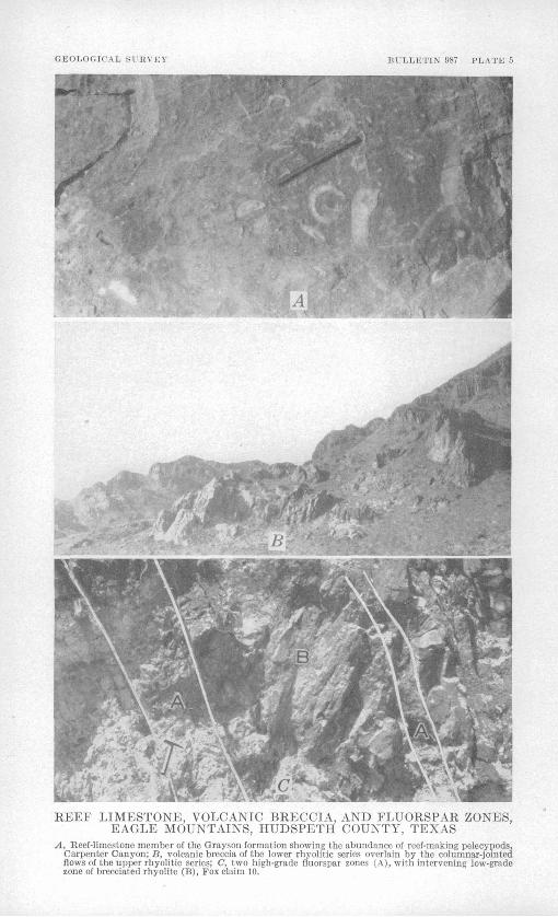
KEEP LIMESTONE, VOLCANIC BRECCIA, AND FLUORSPAR ZONES, EAGLE MOUNTAINS, HUDSPETH COUNTY, TEXAS
A, Reef-limestone member of the Grayson formation showing the abundance of reef-making pelecypods, Carpenter Canyon; B, volcanic breccia of the lower rhyolitic series overlain by the columnar-jointed flows of the upper rhyolitic series; C, two high-grade fluorspar zones (A), with intervening low-grade zone of brecciated rhyolite (B), Fox claim 10.

GEOLOGY . 27
TIPPER CRETACEOUS
The Grayson formation, Buda limestone, and Eagle Ford formation of Late Cretaceous age are found in the Eagle Mountains. The Gray" son and Buda formations have never been previously distinguished within the mapped area, although Smith (1940, p. 616), Baker (1927, p. 30), and Adkins (1932, p. 393) mention them as being present in the Devil Eidge area, and between Devil Ridge and Eagle Spring. The Grayson is given formational rank in agreement with Adkiris (1932, pp. 386-396) and Imlay (1944; 1945a; 1945b), and the Grayson and Buda are both included within the Upper Cretaceous, although they are a part of the Comanche series. The Upper Cretaceous rocks crop out on the northeast side of the Eagle Mountains.
GRAYSON FORMATION
In the Eagle Mountains the Grayson formation is divided on lith- ological and faunal bases into three distinct members for which in ascending order, the following names are proposed: The Carpenter limestone member, the reef-limestone member, and the Eagle Moun tains sandstone member. The middle and upper members occur throughout the Eagle Mountains and adjacent areas and can readily be recognized. They are distinct both lithologically and f aunally, and are valuable guide beds in the stratigraphic section. The lower mem ber, howver, is almost identical in appearance with the uppermost ' part of the Georgetown limestone which it immediately overlies, and from which it is distinguished chiefly on paleontological grounds. .Hence it is not so distinct, as a mappable unit, as the other two members of the Grayson formation. The type exposure of all three members .of the Grayson formation is in Carpenter Canyon at a point about
L mile above Carpenter Wells, (pi. 8). The Carpenter lime stone member of the Grayson formation, named from the excellent exposures in Carpenter Canyon about 1 mile above Carpenter Wells, consists mainly of 90 ft. of nodular thin-bedded black limestones weathering blue gray, and interbedded gray shales (see pi. 45 and pp. 29), and is conformable upon the underlying Georgetown lime stone. Although very similar in appearance to the upper part of the Georgetown limestone, the Carpenter limestone member of the Grayson consists of more regularly interbedded limestones and shales, and the weathered surfaces of the limestones are of a slightly lighter gray.
219618 53 3
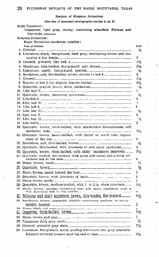
28 FLUORSPAR DEPOSITS OF THE EAGLE MOUNTAINS, TEXAS
Section of Orayson formation
[See line of measured stratigraphic section 6, pi. 8]
Buda limestone:Limestone, light gray, chalky, containing abundant Nerinea and
Twrritella remains. Grayson formation:
Eagle Mountains sandstone member:Top of section Feet
1. Covered_______-_____________________________ %2. Limestone, sandy, fine-grained, dark gray, weathering brown and con
taining a few fossils_ _ __ _ ___ 13. Covered, probably like bed 4 1%4. Sandstone, thin-bedded, fine-grained, soft, brown____________ 2*45. Limestone, sandy, fine-grained, grayish______ __________ %6. Sandstone, soft, thin-bedded, brown, similar to bed 4___________ 57. Covered_____________________________________ iy28. Similar to bed 6 but slightly heavier bedded_______________ 2%9. Quartzite, grayish brown, hard, calcareous_________ ____ %
10. Like bed 6_______________ ________l__________ 111. Quartzite, brown, somewhat calcareous_______ __________ %12. Like bed G_______________________________ _- 113. Like bed 11______________________________________ 114. Like bed 6_______________________________________ 115. Like bed 11___________________________________ V216. Like bed 6___________________________________ 117. Like bed 11_____________________________________ V218. Like bed 6_____________________________________ 119. Quartzite, brown, thick-bedded, with interbedded discontinuous soft
sandstone beds_-______ _ _ _ 2%20. Quartzite, brown, heavy-bedded, with fucoid or worm tube impres
sions at the top_______ ______-_-___-___-_ . 221. Sandstone, soft, thin-bedded, brown__________________>__ %22. Quartzite, thin-bedded, with interbeds of soft shaly sandstone-___ 123. Quartzite, brown, thick-bedded, with shaly sandstone interbeds .__ 2%24. Quartzite, reddish, thin-bedded, with many soft layers and a thick cal
careous bed at the base _ 525. Shale, brown, sandy___ __ _ V>
26. Quartzite, brown_____ %27. Shale, brown, sandy toward the base___________l_____ 128. Quartzite, brown, with interbeds of shale____ __ _ 129. Shale, brown, sandy_______________________________ 130. Quartzite, brown, medium-bedded, with 1- to 2-in. shale interbeds 3y2SI. Shale, brown, grading downward into soft shnly sandstone with a
9-in. quartzite toed in the middle _ _ ___ _ 4
32. Siltstone and slmly sandstone, Drown, tliin-Dedded, fine-grained vfa33. Sandstone, brown, quartzitic, slightly calcareous, medium- to heavy-
bedded, banded________-_____ 234. Slime, UlacK and gray___' __ - 1
35. Quartzite, tliick-Deflded, Drown 1%36. Shale, brown and gray______ 137. Limestone, dark gray, sandy V-l
38. Covered, probably gray shale______________________ 1%39. Limestone, fine-grained, sandy grading downward into gray quartzite.
Exogyra cartledgi present near top and at base____________ 2%

GEOLOGY 29
Section of Grayson formation Continued Grayson formation Continued
Eagle Mountains sandstone member ContinuedTop of section feet
40. Shale, brown and interbedded quartzite with abundant Exogyracartledffi which weather free _ 6
ftftl/Reef -limestone member: ya
41. Limestone, dark gray, granular, thick-bedded, with abundant rudistidremains. Rough weathering and forming a 5%-ft cliff 5%
42. Limestone, black, weathering blue-gray, thin-bedded, semi-nodular,smooth-weathering, contains some rudistid remains 4
43. Similar to above but probably containing some shale interbeds ; more nodular and thinner-bedded, and rudistid remains abundant especi ally toward base 9
45. Limestone, nodular, similar to bed 43, with abundant rudistid remains. 9 posed almost wholly of rudistid remains toward top_ 2%
44. Similar to bed 41, but thinner-bedded and forms a smaller cliff ; com-46. Limestone, black, black-weathering, fine-grained, consisting almost
wholly of rudistid remains, many of which are well preserved. This bed contains an abundance of corals at other localities, but they are scarce at this locality. Cliff -forming at this locality, but at other places is soft, and fossils weather out _ _ _ _ 3
47. Limestone, black, weathering gray, thick-bedded, cliff-forming, withabundant fossils in the upper part _ _ _ _ _ _ 1
48. Similar to bed 47 but not as fossiliferous, although carries rudistid remains throughout; becomes coarser-grained and thicker bedded toward base ___ ___ __ _ _ _ _ _ _ _ 14
49. Similar to bed 48 but thinner-bedded and partly covered __ __ _ _ 550. Limestone, dark-gray to brownish, granular, consisting of minute shell
fragments and small pebble like particles imparting a conglomeratic appearance under a hand lens; is cliff -forming' and rough-weathering and gray 'on weathered surface ___ _ ________________ _ 8%
Carpenter limestone member : 61. Limestone, dense black, weathering blue-gray _____________ l J52. Limestone, thin-bedded, similar to bed 51 but with shale interbeds
and a 6-in. shale bed at the base; very fossiliferous but containing no rudistid or coral remains. Exogyra, arietina abundant ____ 3
53. Limestone, black, weathering blue-gray ___________________54. Shale, gray _____ __ ______ _______________________55. Limestone, black, weathering blue-gray, thin-bedded, nodular, rough,
very fossiliferous with abundant Exogyra, arietina and Exogyra, ilralcel _________________________________________________________ 3;
5(5. Limestone, black, weathering blue-gray, thick-bedded, becoming nodular toward the base; cliff -forming fossiliferous at top ________ 12
57. Limestone, weathering blue-gray, thin-bedded, nodular, with shale interbeds ; a few thin beds without nodules throughout the series. Contains Grayson fossils throughout the upper part; a 1-ft bed at the base contains abundant Kingena ; the lower part of this series may belong to the Georgetown formation ________________ 69
90Total Grayson formation________________________ 220

30 FLUORSPAR DEPOSITS OF THE EAGLE MOUNTAINS, TEXAS
Georgetown limestone:58. Similar to bed 57, but containing Georgetown fossils.
Fossils are extremely abundant in the Carpenter limestone member of the Grayson formation and, in contrast, are less abundant in the upper part of the Georgetown limestone. The abundance and dis- tinctiveness of the fossils are useful in distinguishing the Carpenter member from the Georgetown limestone. The lower limit of the Carpenter is arbitrarily drawn at a point 20 ft above a bed Carpenter member is arbitrarily drawn at a point 20 ft above a bed containing abundant Kingena sp., which lies approximately 90 ft below the bottom of the reef-limestone member of the Grayson forma tion. A, distinct saddle, or change in slope, is characteristic of the soft Carpenter member and the upper part of the Georgetown lime stone, as distinct from the cliff-forming overlying reef-limestone.
Fossils are abundant in the Carpenter limestone member of the Grayson formation, particularly in the upper part. Collections made in Carpenter Canyon include Enallaster texanus (Reomer), Glyp- eopygus angustatus (Clark), Exogyra arietina Roemer, Exogyra, drakei Cragin, Exogyra cf. E. drakei Cragin, Exogyra sp., Neithea- cf. N. budensis Kniker, Neithea texana (Roemer), Neithea sp., Lima shumardi Shattuck, Protocardiaf sp., Turritellaf sp., Anchura? sp., and Kingena sp.
The reef-limestone member of the Grayson formation has been traced along the northeastern side of the Eagle Mountains from south of Spar Valley to the Devil Ridge area. It is interrupted in places by rhyolite and has been offset by faults, but is persistent anduniform and is readily recognized by its abundance of rudistid remains(pi. 5A}. Typically it consists of massive gray rough-weathering limestones with some nodular beds in the upper part. About midway in the series is a very distinctive extremely black granular thinlybedded soft limestone about 3 ft thick consisting almost wholly of remains of the reef-making rudistid pelecypods. Corals are abundantlocally in this bed.' The bcase of the series consists of beds of granular .Oolitic limestone with abundant shell remains. The gray limestones:also contain abundant rudistid remains, especially in the upper part. The reef-making pelecypods and corals, so abundant in the reef- limestone member, are mostly new species, many of them new genera, and bear little relationship to the fossils from the rest of the forma tion. Some of the corals are new to America, and the wholeassemblage is of a type not previously found in the Grayson formation. .Most of the fossils were collected about 5V2 miles northwest of EagleSpring on the road from Grayson station to the Babb ranch
house"at a point 6 miles south of the Southern Pacific Railroad,northwest of the area shown on plate 1.

GEOLOGY 31
These fossils were identified: xAstrocoenia pattoni Wells, Stephanocoenia saxi-rotimdi Wells,
Heterocoenia n. sp., Myriophyllia n. sp., Felixigyra n. sp., Thamna- steria hoffmeisteri Wells, Calamophyllia n. sp., Periseris n. sp., Miceo- solena n. sp., Cladophyllia sp. aff. C. furcifera Roemer, Montastrea texana (Vaughan), Montastrea pecosensis Wells, Montastrea n. sp., Placocoenia n. sp., Agathelia n. sp., Heliopora n. sp., Stromatoporel- lina n. sp., Caprinula? n. sp. cf. C. crassifibra Roemer (also resembles Sphaerucaprina occidentalis Conrad), Toucasia cf. T. texana (Roemer), Caprotina n. sp., Corbisf n. sp., Trochus n. sp., Pleuroto- mariaf n. sp., Tylostoma sp., Nerinea n. sp. cf. N. incisa Giebel, Nerinea sp., Ostrea sp., Artica cf. A. roemeri (Cragin), Turbo? n. sp.
The Eagle Mountains sandstone member of the Grayson formation, named from the excellent exposures on the north side of the Eagle Mountains, is also a distinct and persistent member and is found throughout the mapped area adjacent to the reef-limestone member except where rhyolite intervenes. About 70 ft of interbedded brown sandstones (some of which are quartzitic), brown shales, siltstones, and sandy limestones make up the member. The characteristic brown color of the beds contrasts strongly with the dominant blue-gray color of the other formations of late Comanche age. Exogyra cartledgi Bose is charcteristic of the Eagle Mountains member and is abundant in the beds immediately overlying the reef-limestone member. Other fossils identified are Protocardia sp., and Trigovdal sp.
BtTDA LIMESTONE
The Buda limestone consists of massive chalky light gray limestones very distinctive lithologically from the black limestones of the under lying formations. Fossils are scarce or poorly preserved throughout most of the formation, but a persistent bed containing abundant Turri- tella and Nerinea occurs at the base of the formation, immediately above the Eagle Mountains sandstone member of the Grayson forma tion. A maximum thickness of 225 ft was measured in the area to the southwest of Carpenter Canyon from the top of the Grayson formation to the bottom of the overlying Eagle Ford formation, but owing to the unconformable overlap of the Tertiary volcanic rocks, the entire formation is not present in many places.
The Buda limestone is conformable with both the underlying Gray- ^on fromation and the overlying Eagle Ford formation, the contact with the Grayson formation being marked by the Turritella-Nerinea bed. Fossils found in this bed include Turritella sp., Nerinea sp., Lima shumardi Shattuck, Pholadomya shattucki Bose, Lsocardia sp., Exogyra sp., Tylostoma cf. T. harrisi Whitney, and Enallaster texanua (Roemer).
»Identification made by J. W. Wells and R. M. Imlay, U. S. Geological Survey, April 1047.
32 FLUORSPAR DEPOSITS OF THE EAGLE MOUNTAINS, TEXAS
EAGLE FORD FORMATION
The Eagle Ford formation conformably .overlies the Buda limestone on the northeastern side of the Eagle Mountains, cropping out in the area northwest of Spar Valley as two continuous belts of varying width, trending northwestward. The formation is especially well developed in the Carpenter Canyon and Eagle Spring areas.
Black and brown fissile shales, gray flaggy limestones, and red and brown calcareous limestones and arenaceous limestones characterize the Eagle Ford formation. Thin sandstone and siltstone beds are also present. In the vicinity of Eagle Spring several small coal seams are interbedded with the black shales. Some of these seams have been worked in the past. Rhyolite sills have invaded the formation causing local folding and contortion of the shale beds. Fossils are numerous in the black shales of the upper part of the formation and in some of the calcareous sandstone beds. The thickness of the formation varies greatly, owing to the fact that it is overlain unconformably by the extruded lavas and pyroclastic rocks of the lower rhyolitic series. Taff (1891) measured 1,130 ft in Carpenter Canyon, and Smith (1941, p. 74) records more than 1,400 ft in the Eagle Spring area. Probably an even greater thickness is present in the area northwest of Carpenter Canyon. ,
An excellent section of the Eagle Ford formation is exposed in Carpenter Canyon from a point slightly more than a half-mile below Carpenter Spring to a point about one-fourth mile above Carpenter Spring (pi. 1). This section was measured by Taff (1891, p. 734) and his section is quoted below.2Measured section of Eagle Ford formation along Carpenter Canyon from a point
about half a mile below Carpenter Spring to a point about a fourth of a mile above (See pi. 1)
Eagle Ford or Benton shale division:Top of section Feet
1. Very fissile, black, slightly arenaceous clay shale, with numerous indi viduals of a small Inoceramus and a fragile oyster or anomia ____ 300
2. Flaggy, fissile, calcareous, argillaceous sandstone, with numerous oystershell fragments and an Inoceramus at the upper edge____________ 430
3. Siliceous limestone with oyster_______-._____ __ 30,760
Lower Cross Timber or Dakota division:1. Calcareous, flaggy sandstone, with oyster shell fragments 60
2. Fissile, dark shale, grading upward into arenaceous shale, with bandsof argillaceous sand_____________ ____________________ 220
3. Fissile brown shale_________._______ _ 504. Cream-colored to brown lassie calcareous snale__________ ___ so
360i, 120
8 Taff's separation of the series into the Eagle Ford or Benton shale division, and the Lower Cross Timber or Dakota division is not valid today, although Adkins (1932, pp. 407-408, 422-439) gives the Eagle Ford the rank of a group and divides it into a number of formations some of which may correspond to Taff's divisions.
GEOLOGY 33
Fossils collected in the vicinity of Carpenter Spring include Coilop- ceras sp., Romaniceras? sp., Ostrea soleniscus Meek, and Inocera/mus sp.
In the southeast part of the mapped area near the mouth of Spar Valley and south of the Wind Canyon fault (pi. 1) thin-bedded pink sandstones and thin-bedded grayish-pink sandy limestones are re ferred to the Eagle Ford formation. These beds apparently overlie the Buda limestone. They dip in the opposite direction, however, and are usually separated from the Buda limestone by rhyolite sills. No fossils were found in these rocks, and further study of the geology southeast of the area mapped is necessary to determine the true nature of the relationships and the exact age of the beds.
QUATERNARY
TERRACE DEPOSITS, YOTTNGER ALLUVIUM, AND BASIN FILL
Quaternary fluvial deposits along the lower courses of the streams have been divided into the older terrace deposits and the younger alluvium. The two deposits are shown separately on plate 10, but are mapped together on plate 1. The terrace deposits are widespread and occupy most of the broad val leys along the lower courses of the major streams. They consist essentially of gravel, sand, and silt carried down by the stream from the adjacent uplands and deposited as valley fill during the preceding erosion cycle. The surfaces of the terraces are about 20 ft above the present stream beds and are indicative of a recent uplift of the area with a subsequent downcutting of the streams below their former level. Excellent examples of the terrace deposits can be seen in the lower reaches of Spar Valley and in the area between Carpenter Wells and Lone Hill.
The younger alluvium deposits are restricted to the bottom of the present stream valleys and consist of unconsolidated coarse gravel and sands.
The terrace and younger alluvium deposits merge at the edge of the mountains with the large alluvial fans that slope down into the bolson deposits of the intermontane basins. This basin fill consists of boulders, gravel, sand, silt, and clay, the coarser material lying adjacent to the mountain slopes and the finer silts and clays pre dominating in the centers of the basins. Caliche-cemented conglom erates are present locally in the bottoms of some of the arroyos. The thickness of the basin fill is not known. At Hot Wells near the center of the basin two wells have penetrated the fill to depths of slightly more than 1,000 ft, and wells at the head of Green River, southeast of Hot Wells, bottom in fill at 1,100 ft. A well at the Babb ranch, near the edge of the mountains about 5 miles west of Eagle Spring,

34 FLUORSPAR DEPOSITS OF THE EAGLE MOUNTAINS, TEXAS
reaches a similar depth and is still in fill. At Sierra Blanca a well penetrated the fill to a depth of 880 ft at a point just i/^-mile east of the nearest outcrops on Texas Mountain. Baker (1927, p. 40) reports 4,910 ft of fill in the Hueco basin to the northwest.
IGNEOUS BOCKS
Both extrusive and intrusive igneous rocks occur in the Eagle Mountains. The extrusive rocks are predominant, occupying most of the mountainous area within the ring of sedimentary rocks. The central, higher part of the mountains, however, is occupied by an intrusive stock of syenite. Dikes and sills are present throughout the area,
EXTRUSIVE BOCKS
The extrusive rocks can be divided conveniently into three groups: The lower rhyolitic series, including rhyolitic flows, tuffaceous sedi ments, volcanic breccias, and welded tuffs; trachyte porphyry; and the upper rhyolitic series, including rhyolitic flows, tuffaceous sedi ments, and volcanic breccias.
The contact between the trachyte porphyry and the upper rhyolitic series is sharp and pronounced. Evidence of a considerable time in terval between the extrusion of the trachyte porphyry and the over lying rhyolite is indicated by the presence of conglomerate at the base of the upper rhyolitic series, which contains large boulders of trachyte porphyry. The variable thickness of the trachyte porphyry and its absence on the southwestern side of the mountains (5/?) may be sup porting indications of this erosion interval or may be due merely to the irregular distribution of the extrusive lavas. The contact of the trachyte porphyry and the lower rhyolitic series, however, appears to be gradational. Flows of trachyte porphyry are present in the
uppermost part of the lower rhyolitic series, and the upper units ofthat series tend toward a trachytic composition. Apparently the ig neous activity was continuous, with a gradual change in compositionof the parent magma.
No definite evidence for dating the volcanic rocks in the Eagle Mountains has been found but in the area southeast and east of the
Eagle Mountains fossil plant and vertebrate remains seem to indicate an early Oligocene or Eocene age for the lower tuffaceous units of thevolcanic series in tnat area. (Plviinmer, 193S, pp. 804 805). Bon6S Ol a
land tortoise Of Supposedly late Tertiary age have been reported from the tuffaceous sediments of the Eagle Mountains. The volcanic activ-ity probably Continued for some time, well into Miocene and. possibly
Pliocene times.

GEOLOGY 35
LOWER RHYOLITIC SERIES
The lower rhyolitic series consists of 500 ft to 1,000 ft of fhyolite flows, flow breccias, tuffaceous sediments, volcanic breccia, and welded tuffs. They were laid down upon an uneven erosion surface -of moderate relief and are in nnconformable contact with rocks of both Late and Early Cretaceous age.
On the west and southwest side of the mountains tuffaceous sedi ments and volcanic breccia predominate. The tuffaceous sediments are buff-colored, thin-bedded, well stratified, and dij) about 30° NE. The volcanic breccia is thick-bedded, light gray or buff, and also dips about 30° NE. The breccia contains many volcanic bombs as much as 6 in. in diameter, and fragments of rhyolite, quartzite, and lime stone. Quartz and feldspar crystals are present in both the tuffaceous sediments and the volcanic breccia.
In the vicinity of Spar Valley the lower part-of the series consists of flows of porphyritic rhyolite containing quartz and sericitized orthoclase phenocrysts in a fine-grained groundmass. Small grano- phjTic intergrowths of quartz and orthoclase can be observed in some specimens. Flow banding is common, and flow breccias containing fragments of rhyolite and sedimentary rocks are present. The upper part of the series, as exposed in the vicinity of Shaft 4, and in th,e valley of Little Spar Creek (pi. 8), is more andesitic in composition and is a buff-colored to yellowish-gray weathered lava composed of phenocrysts of albitized plagioclase and a little orthoclase in a ground- mass of quartz and feldspar. The dark minerals originally in the rock have been oxidized. Kock fragments are numerous.
In the Carpenter Canyon area and northwest toward Eagle Spring, light gray and buff-colored tuffaceous sediments and volcanic breccia are common in the lower part of the series. The tuffaceous sedi ments are thin-bedded and well stratified, and dip southwest. The volcanic breccia is thick-bedded and forms the precipitous cliffs at T-C Peak and Panther Bluff. The breccia contains many fragments of foreign material. Blocks of quartzite, limestone, and spherulitic rhyolite as much as 5 ft in diameter were observed on the east side of T-C Peak. Little, if any, sorting was discernible. The upper part of the series is predominantly buff-colored soft-weathering flows and flow breccias. Flow banding and vesicular structures are abundant. Spherulitic rhyolite occurs in the area southwest of Carpenter Spring and thin beds of pitchstone, vitrophyre, and perlite are present near Eagle Spring and Panther Bluff. The glassy rocks are of small areal extent and are interbedded with the flows and flow breccias.
Welded tuffs occur near the top of the series south of Wind Canyon. The individual beds are thin and interbedded with tuffaceous sedi ments.

36 FLUORSPAR DEPOSITS OF THE EAGLE MOUNTAINS, TEXAS
TRACHYTE PORPHYRY
The trachyte porphyry with thin beds of trachytic tuffaceous sedi ments crops out in a thin band southeast of Spar Valley, thickens to ward the west, and occupies much of the area in the northwestern part of the mountains where it attains a thickness of at least 600 ft. It is riot present on the southwestern side of the mountains. Many small outliers occur in the Eagle Spring area where they are found as erosional remnants capping small hills. The upper part of the lower rhyolitic series grades upward into typical trachyte porphyry. To ward the west the contact is sharper, and on the west side of the, mountains, in the vicinity of Black Butte, west of the mapped area, the dark red color of the trachyte porphyry is in sharp contrast to the light color of the underlying rhyolitic volcanic breccias.
Typically, the trachyte porphyry is a dark red to reddish-purple rock with large orthoclase phenocrysts in a fine-grained groundmass of orthoclase and a little quartz. Magnetite and hematite are com monly abundant. Albitized plagioclase feldspars are present locally, and a graphic intergrowth of the albite and quartz is generally ob served. In the eastern part of the area, the feldspars are cloudy and extensively altered, the dark minerals have been altered to the oxides of iron and to carbonates, and apatite and a greenish-mineral resemb ling an amphibole are present. The rock weathers to grayish pink. South of Spar Valley the lower part of the trachyte porphyry con sists of altered light-gray and brownish rock with large phenocrystsof albitized plagioclase, grading upward from similar rocks of the
lower rhyolitic series. The lowest part is overlain by the less alteredgrayish-pink rock, which in turn is overlain by the relatively un altered dark red trachyte porphyry. These three rock types mayrepresent distinct flows of slightly different composition. The dark
red trachyte porphyry is predominant in the Western part Of the mountains.
The trachyte porphyry is overlain by a basal volcanic conglomerateOf the Upper rhyOlitiC Series. ThiS basal volcanic conglomerate con tains boulders of trachyte porphyry in a matrix of rhyolite and IS well exposed about three-fourths of a mile north, of the Eagie Mountain
ranch house in Syphon Canyon. Although most of the trachyte porphyry is believed to be extrusive
in origin, the outliers in *i« E^SI«, sPx-i«s .«*«. «.«a some of the
trachyte porphyry within the upper rhyolitic series m the spar vaiievarea may be intrusive. The evidence is not conclusive, but in tuft
Eagle Spring area the outliers of trachyte porphyry Seem to OCCUI'as sills within the lower rhyolitic series and the cretaceous sedimen tary rocks, or between the two units. The texture of much of the trachyte porphyry and the absence of flow banding and vesicular

GEOLOGY ,37
structure is further evidence of the intrusive character of some of the rock.
UPPER RHYOLITIC SERIES
At least 1,500 ft of rhyolite flows and flow breccias, with a few interbedded volcanic breccias, tuffaceous sediments, and spherulitic rhyolite flows, lie above the trachyte porphyry. Two major types of rhyolite are present, the exact relationships of which are obscure. A light-gray flow breccia contains many fragments of earlier solid ified parts of the same lava, as well as fragments of other rock types picked up by the flowing mass. Phenocrysts of quartz and sericitized feldspar are present, the quartz crystals commonly partly resorbed. Flow-banding is generally prominently developed, with the extraneous material strung out as elongated and flattened fragments; vesicles are prominent. The flow breccia breaks with a rough fracture; it weathers to' rounded hills and in some places stands as towering spires and cliffs with rounded contours.
The second type is a dense hard flinty-looking rhyolite porphyry, gray to green or buff, with conspicuous, though small, phenocrysts of quartz and some feldspar. The rock breaks with a conchoidal frac ture. Jointing is conspicuous and well developed, and results in angular blocky outcrops and many large and small steep cliffs and narrow canyons.
Adjacent to the intrusive syenite plug, the rock is more calcic in composition, trending toward andesite, and has been recrystallized into a dark-gray, slightly coarser-grained rock. Quartz and large oligbclase phenocrysts, some albitized, are set in a groundmass of quartz and oligoclase. Clusters of granules of recognizable secondary aegerite augite are present, as well as augite and pigeonite. Magne tite is common. The rock is extensively albitized and was evidently soaked in soda-rich solutions. Farther away from the stock of Eagle Peak syenite (pi. 1) the albitization is localized along fractures.
INTRUSIVE BOCKS
The intrusive rocks of the area are irregular masses, which cut the sedimentary rocks, and sills. They are the Eagle Peak syenite stock, rhyolite dikes and sills, and diabase dikes. The intrusive rocks cut the earlier volcanic rocks and are contemporaneous with the lower rhyo- litic series of extrusive rocks associated with the Eagle Peak syenite stock.
RHYOLITE SILLS
Many sills and irregularly shaped masses of rhyolite intrude the sedimentary rocks in the regions adjacent to the contact of the sedimentary rocks and the lower rhyolitic series. These intrusives

38 FLUORSPAR DEPOSITS OF THE EAGLE MOUNTAINS, TEXAS
are allied to the flows of the lower rhyolitic series. They are part of the same parent magma, being merely offshoots that penetrated the sedimentary rocks adjacent to the vents during the volcanic activ ity. Some of the sills penetrated the sedimentary rocks for a con siderable distance and crop out more than a mile from the contact of the. sedimentary rocks and the lower rhyolitic series. The rhyolite is buff-colored, fine-grained, and contains quartz and sericitized feldspar phenocrysts. Limonite specks are. common. The rhyolite is weathered and soft, except where silicified along fault and fracture planes.
EAGLE PEAK SYENITE
The name Eagle Peak syenite is proposed for the brownish-gray medium-grained rock with large phenocrysts of feldspar, chiefly orthoclase, which occurs in the central and highest part of the moun tains and is exposed on Eagle Peak. The syenite crops out as a roughly elliptical-shaped body with, in the main, almost vertical contacts with the rhyolite. The rock is composed chiefly of orthoclase.
and oligoclase, with small amounts of quartz. Altered biotite is abundant; a few grains of zircon and some secondary carbonate min erals are also present. Where the Eagle Peak syenite has been altered by the alkaline solutions that were so prevalent in the area, the feldspars have been albitized, and a graphic intergrowth of quartz and Secondary albite is conspicuous. The abundance of albiteapparently justifies the term "soda Syenite" for the altered FOCk.
The altered syenite is well shown on the summit of Eagle Peak and
also in the vicinity of the fluorspar deposits on Fox claims 1 and 3,Slightly more than l1/^ miles southeast of Eagle Peak. The unaltered
syenite is well exposed on the flanks of Eagle Peak and in Wind Canyon both immediately above and immediately below the smallwindmill (pi. 1) 11/2 miles southeast of Eagle Peak.
The Eagle Peak syenite appears to have intruded the upper rhyo-
litic series as a small stock. Two small isolated areas are present
east of the main body and represent offshoots of the main mass. Tothe south, the contacts with the rhyolite are not vertical, as on the other sides of the stock, but are concordant with the flows. The syenite apparently Split Some Of the flows apart at this locality and invaded tKem as a sill-like protrusion from the main stock.
DIABASE DIKES
Diabase dikes are present on the north side of the mountains southof Lone Hill, on the northeast side of the mountains in the vicinityof the Marine ranch house, and on the southwest side of the moun tains near the mouth of Snowline Canyon and in the Rocky Ridge area on Snowline Ridge. The dikes on the northeast side of the
GEOLOGY d9
mountains are small and of limited extent, but the dike in the Rocky Ridge area can be traced for about 3,000 ft and is from 4 to 6 ft thick. This dike cuts both the sedimentary and volcanic rocks in the Rocky Ridge area. It is dark blue-gray, dense, medium-grained, and even- textured. Thin section studies show this rock to be a diabase 3 and to be composed chiefly of long thin laths of plagioclase feldspar. The mafic minerals have been completely altered, and grains of cal- cite and specks of magnetite and limonite are abundant. About a mile to the west, what apparently is an extension of the same dike crops out near the mouth of Snowline Canyon. The dike at this place is much thicker, however, cropping out over a width of 50 ft; the rock is coarser grained, and the diabasic texture is more pro nounced. Quartz is present, and the rock may be called a quartz diabase. Plagioclase feldspar, chlorite, and calcite are the most conspicuous minerals in the dike at this locality.
LATE RHYOLITE DIKES
Rhyolite dikes belonging to a late stage of intrusive activity are present in the Spar Valley area, the Eagle Spring area, and in the central part of the mountains. These dikes commonly are intruded along the east-trending faults. The rhyolite is soft, white or pale bluff, platy with vertical jointing or flow-banding, locally spherulitic, and slightly porphyritic. The spherules consist of radiating struc tures around spherical grains of quartz. The radiating fibers are composed of orthoclase bound together by tridymite. The rock may be called a spherulitic rhyolite. The dikes are vertical or steeply dipping and intrude the sedimentary and volcanic rocks; they have not been found intruding the syenite. They appear to represent the last stage of igneous activity in the Eagle Mountains, prior to the fluorspar mineralization.
STRUCTURE
The Eagle Mountains, along with the Devil Ridge, Quitman Moun tains, and Malone Mountains to the northwest, are part of an over- thrust area termed by Baker (1934a, p. 156) the "Mexican Overthrust Province." The area is characterized by intense folding and faulting, and by great overthrusts trending roughly northwest. The thrust ing is from the southwest. Smith (1940, pp. 629-632) has identified two large thrusts in the Devil Ridge area; and similar thrusts, possibly continuations of the Devil Ridge thrusts, have been mapped in the Quitman Mountains (Huffington, 1943, pp. 1022-24). Similar thrusts, which may or may not be continuous with the Devil Ridge thrusts, are present in the Eagle Mountains. Possibly two periods
3 Studies of thin sections made by Jewell J. Glass, U. S. Geological Survey, August 1945,

40 FLUORSPAR DEPOSITS OF THE EAGLE MOUNTAINS, TEXAS
of thrusting occurred, the earlier of which, accompanied by gentle folding, preceded the igneous intrusions and subsequent downwarping of the central part of the Eagle Mountains. Four series of normal faults have been recognized in the area. The major folds and faults, as well as the locations of the principal fluorspar deposits, are shown on plate 2.
FOOTING
The Van Horn dome and the Eagle Mountain syncline are the major structural features of the area.
The pre-Cambrian Carrizo Mountain schist cropping out low on the northeast side of the mountains is part of the central core of the Van Horn dome. The greater part of the dome, however, is outside the mapped area. Paleozoic and Mesozoic sedimentary rocks dip away from the central core, but within the mapped area this is modified by faulting south of the pre-Cambrian rocks. The regional south westerly dip of the rocks on the northeast side of the Eagle Mountains is due to their being both on the southwest side of the Van Horn dome and on the northeast side of the Eagle Mountain syncline.
The Eagle Mountain syncline trends northwest and its axis parallels and closely corresponds to the axis of the range. The sedimentary rocks on the northeast side of the mountains dip 25°-35° southwest with local variations due to faulting and intrusive activity. On the southwest side of the mountains the sedimentary and volcanic rocks dip about 25° northeast and east-northeast. The trough of the syn cline is occupied by the volcanic rocks and the intrusive Eagle Peak syenite. This synclinal structure may prove to be basinlike in outlinewhen mapping is done to the northwest and southwest. The syncline was formed after or during the extrusion of the volcanic rocks, perhaps at the same time that the Van Horn dome was formed, and may have been due to a readjustment resulting from igneous activity and the subsequent overloading by the volcanic rocks.
A regional discrepancy in dip between the-sedimentary rocks and theTolcanic rocks on the northeast side of the mountains is best shown in the area between Eagle Spring ^ Carpenter Canyon, and in the -area south of Eagle Spring, The sedimentary rocks have a regionalflip Of 25°-50° SW., ^ith. looa,l ^a^-i^tlo^s boyo^d tkat range. The
illffaCeOUS SBdiineiltS near the base of the lower rhyolitic series dip
15°-20° SW. This discrepancy is due to an early pftrfod Of g6Iltl6 folding accompanying the Devil Ridge thriist,' before the extrusionof the volcanic rodra.
A small syncline is present in the area between Lone Hill fllld (jell1 " penter Canyon. The strata, which in this area normally dip south west, have been dragged up by faulting, causing a reversal of dip*The drag was probably due to the apparent westward and upward
GEOLOGY 41
movement of the block lying north of the Eagle Spring fault. The syncline plunges to the south and is cut off in that direction by the Carpenter fault. Exposed formations involved are the Georgetown, Grayson, Buda, and Eagle Ford. The last occupies the trough of the syncline.
Minor folding and distortion of the strata due to faulting or igneous activity are prevalent in most of the area.
FAULTING
Faulting is extensive in the area, and at least six different systems of faults are recognizable. Joints and other fractures, especially abundant in the volcanic rocks, parallel the trend of the major faults, particularly those belonging to the northeast-trending system. The relative age and character of the major faults are well established, with the notable exception of the Spar Valley fault and a possible fault lying one-fourth mile east of the Black Hill Shaft in the ex treme southwestern part of the mapped area. The fault systems will be discussed in the order of their relative ages, beginning with the oldest.
DEVIL RIDGE THRUST FAULT
The earliest fault recognizable in the area is the Devil Kidge thrust fault which is best exposed a quarter of a mile south of Eagle Spring. The thrust strikes northwest to north-northwest and parallels the regional strike of the sedimentary rocks. The thrusting along the fault was from the southwest.
In the vicinity of Eagle Spring the presence of the fault is indi cated by the flat-lying Bluff Mesa formation overlying steeply dipping contorted rocks of the Eagle Ford formation. This relationship is
. best seen on the slopes of T-C Peak, just southwest of Eagle Spring, although the actual fault contact is obscured by overburden and talus. The sinuous trace of the fault at this locality is due to a combination of topography and the fact that the fault is flat-lying or dips slightly southwest. Northwest of T-C Peak the thrust can be traced inter mittently to the Devil Kidge area. To the southeast, it is covered by rhyolite flows and tuffaceous sediments of the lower rhyolitic series which rest in normal contact upon the Eagle Ford formation. Ex cellent exposures of this contact are on the west side of Carpenter Canyon about 1,000 ft south of Carpenter Spring. Small klippen of limestone of the Bluff Mesa formation are present northeast of the main overthrust block.
Boulders and large masses of limestone of the Bluff Mesa forma tion are embedded in the rhyolite flows in the vicinity of T-C Peak and to the northwest and southeast, even where the Bluff Mesa forma tion at present does not overlie the Eagle Ford formation. This is

42 FLUORSPAR DEPOSITS OF THE EAGLE MOUNTAINS, TEXAS
particularly evident about half a mile southeast of T-C Peak where the basal part of the extrusive rocks consists almost entirely of large boulders of limestone of the Bluff Mesa formation in a matrix of volcanic material. As the thrusting preceded the volcanic activity, the Bluff Mesa was evidently the surface rock in these areas at the time the lavas were extruded. Because the volcanic rocks which cover the Devil Ridge thrust fault southeast of Eagle Spring are part of the lower rhyolitic series, the Devil Ridge thrust fault must have preceded the earliest volcanic activity. Because the volcanic activity is believed to be of middle Tertiary age (Baker, 1927, p. 35), the thrusting is considered to have been associated with the mountain building of the Laramide revolution.
NORTHEAST-TRENDING FAULTS
High-angle normal and reverse faults, trending northeast, are the most common faults in the Eagle Mountains (pis. 1 and 2). Numer ous faults of this type have been mapped, and many others undoubt edly exist. These faults cut rocks of all ages except the Eagle Peak syenite and, with the exceptions noted below, the late rhyolite and diabase dikes. Half a mile to a mile northwest and west of the Marine ranch house two late rhyolite dikes seem to be offset by faults that trend northeast and dip steeply southeast. These dikes apparently belong to the northeast-trending system, but there may have been renewed movement along them since the late rhyolite dikes were intruded.
The faults are as prevalent in the volcanic rocks as in the sedimen tary rocks and trend at right angles to the general strike of the strata. Well-developed joints and other fractures parallel to these faults are characteristic of the volcanic and sedimentary rocks. Slickensided surfaces and quartz, calcite, and fluorite were observed in many placesalong the fault planes. Some of the large fissure veins of fluorspar '
are present along faults of this series. Displacement may range fromonly a few feet to hundreds of feet.
SPAR VALLEY FAULT
The Spar Valley fault extends down the valley of Spar Creek south eastward from the vicinity of shaft 1. To the northwest it is cut off by the Rhyolite fault, although a fault extending north from theRhyolite fault In the Vicinity Of Shaft 2 may be the continuation of
the Spar- Valley fault. The fault dips 20°-30° SW in the VlCinityof shaft 1 and strikes north-northwest, roughly paralleling ^ aten»of the sedimentary rocks. The low angle of the fault and the high
angle of the sedimentary rocks cause a cutting Ollt Of Strata, In the vicinity of shaft 1 at least 150 ft Of Strata is missing -, southeastward apparently an even greater thickness is missing, owing either to a

GEOLOGY 43
flattening of the fault plane or a steepening of the dip of the sedi mentary rocks. The fault extending north from the Rhyolite fault and possibly representing the continuation of the Spar Valley fault
also causes a cutting out of strata.Four diamond drill holes in the vicinity of the Spar Valley fluorspar
deposits passed through the Spar Valley fault and bottomed in the quartzite of the Cox sandstone (pis. 11 and 14), and the fault plane itself is exposed in the south end of the drift on the 200-ft level in shaft 1 (pi. 13). Quartzite of the Cox sandstone at this place is sepa rated from the overlying black limestone of the Finlay limestone by a layer of black clayey gouge with slickensided surfaces. The fault dips 25° NW. at this locality.
The upper part of the Finlay limestone and the lavas of the lower rhyolitic series are in contact along the fault with various beds of the middle and upper parts of the Cox sandstone and with rhyolite sills that intrude the Cox sandstone (pis. 1, 8, and 10). This cutting out of beds, the total thickness of which may be as much as 300 to 400 ft, is due to the dip of the fault now being less than the dip of the strata involved and may be accounted for either by normal faulting or by thrust faulting (fig. 3).
The Spar Valley fault may be a normal fault (fig. 3B) that'occurred after the extrusion of the rhyolitic series, but before the tilting, and was later involved in the tilting. If this is so, the original dip of the fault must have been about 20°-35°. This very low angle of dip is not common among normal faults.
Or, the Spar Valley fault may be a thrust fault (fig. 3A), the thrusting taking place after the extrusion of the lower rhyolitic series and after the tilting of the sedimentary rocks. Baker (1934a, pp. 150, 165, 189-190) states that there were two periods of thrusting in West Texas: one at the time of the Laramide revolution and the other after the extrusion of the Tertiary volcanic rocks. In the Eagle Mountains the Devil Ridge thrust represents the first period of overthrListing. The Spar Valley fault would represent the second period. Too, the northeast-trending faults are believed associated with the doming of the area of the pre-Cambrian rocks, the folding of the strata into the Eagle Mountain syncline, and the accompanying middle Tertiary volcanic activity. Because the Spar Valley fault offsets the northeast-. trending faults and is definitely of a later period, it must also be later than the middle Tertiary folding or at least simultaneous with, the later stages of the folding. Consequently, it could not be an early normal fault that was involved in the folding, but would instead be a thrust fault that was formed after the folding of the strata.
Evidence is too inconclusive to indicate positively that one hy pothesis is better than the other, but it would seem to favor the thrust faulting.
210018 5:1 4
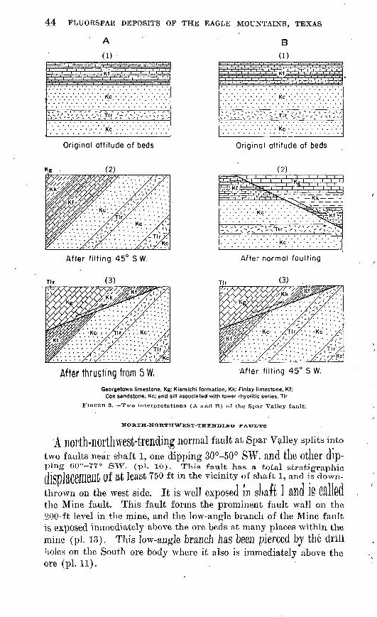
44 FLUORSPAR DEPOSITS OF THE EAGLE MOUNTAINS, TEXAS
A B
(1) (1)
Kc
Original attitude of beds
i '. i ', i '. i ! i '. i ', i '. i ' i ', kf '. i '. i '. i '.
.......... Kc . . . . .
............ Kc
- \ - '-- > -
Original attitude of beds
After tilting 45° SW.
After thrusting from SW,
After normal faulting
After tilting 45° S W.
Georgetown limestone, Kg; Kiamichi formation, Kk; Finlay limestone, Kf; Cox sandstone, Kc; and sill associated with lower rhyolitic series, Tlr
FlGUUB 3. Two interpretations (A and B) of the Spar Valley fault.
NORTH-NORTHWEST-TRENDINe FATJLXS
A north-northwest-trending normal fault at spar Vaiiey splits intotwo faults near shaft 1, one dipping 30°-50° SW. and the other dip ping 60°-YY° SW. (pi. 10). This fault has a total stratigraphic diSDteC6U161lt Of ftt least 750 ft in the vicinity of shaft 1, and is down-
thrown on the west side. It is well exposed in start 1 aim 18 CdlM the Mine fault. This fault forms the prominent fault wall on the 200-ft level in the mine,, and the low-angle branch of the Mine fault is exposed immediately above the ore beds at many places within themine (pi. 13). This low-angle branch has been pierced by the drillholes on the South ore body where it also is immediately above the ore (pi. 11).
GEOLOGY x 45
Red and chalky-white clay gouge, as much as 5 ft thick and showing many slickensided surfaces, is exposed along both the low-angle and high-angle branches of the fault in the mine and is revealed else where by drilling. Shales of the Kiamichi formation, present within the wedge formed by the two branches of the fault, are greatly con torted, and the rhyolite along the west side of the fault in the mine is much brecciated and fractured. The brecciation of the ore beds is due partly to this fault and partly to the Spar Valley fault.
The Mine fault can be followed southeastward along the edge of ,Spar Valley, parallel to the Spar Valley fault but west of it. The lower part of the Finlay limestone on the east side of the fault lies against the middle part of the;Georgetown limestone on the west side of the fault, with rhyolite sills or dikes along the fault plane in .some places.
Northwest of shaft 1 the Mine fault is displaced by the east-trending Rhyolite fault described later. A large fault, extending northwest ward from the Rhyolite fault down the broad valley past the Lucky .Strike fluorspar deposit to Carpenter Wells, beyond which it is lost in the basin fill, may be a continuation of the Mine fault. In the central part of sec. 26 the lower part of the Finlay limestone on the east side of the fault lies against the shales of the Kiamichi forma tion on the west side. About % mile to the north, however, both the .Finlay limestone and the Kiamichi shale are missing, and Cox sand stone on the east side lies against Georgetown limestone on the west .side.
A second north-northwest-trending fault, known as the Carpenter fault, is traceable for 3% miles north of Spar Valley (pis. 2 and 8) from the Rhyolite fault to the Eagle Spring fault. It is displaced westward by the Eagle Spring fault and continues northwestward from this fault beyond the west limit of the map (pi. 1). South of the Rhyolite fault the Carpenter fault cannot be traced within the volcanic rocks, but its presence is indicated south of the Wind Canyon fault by the repetition of strata. The middle part of the Georgetown limestone on the west side lies against the lower part of the Eagle> Ford formation on the east side in most places where the fault is, present within the area shown on plate 1. The result is a repetition of strata. A stratigraphic displacement of approximately 1,000 ft with the west side upthrown, is indicated. The fault is a normal fault in the vicinity of Spar Valley and dips 63°-85° NE. To the north, however, the dip of the fault is reversed and is 60° SW.; hence, in. this area it is a reverse fault.
Normal faults belonging to the same series have been mapped on the southwest side of the Eagle Mountains (see pi. 2). The most prominent is about 3,000 ft east of the Silver Eagle zinc deposit. It

46 FLUORSPAR DEPOSITS OF THE EAGLE MOUNTAINS, TEXAS
can be traced intermittently for about 3,500 ft. The.southwest side has been downthrown, and drag along the fault has produced a re versal of dip in the sedimentary rocks adjacent to the fault plane. Similar faults occur nearby.
Faults belonging to this series exist in other parts of the mountains and may also exist in the Eocky Ridge area. Many of the faults of this area, however, may be the result of the emplacement of the block of sedimentary rocks, as discussed later under the section entitled "Structures due to landslides."
EAST-TRENDING NORMAL FAULTS
Normal faults trending slightly north of east, usually with large horizontal displacements and the south sides apparently displaced eastward, are characteristic of the Eagle Mountains. Baker (1934a, p. 205) mentions one fault of this type in the southern Quitman Moun tains and three in the northern Eagle Mountains. One of the later is the Eagle Spring fault. This fault passes through Eagle Spring and extends westward beyond the mapped area. Near Eagle Spring the fault splits. The northern branch, called the Lone Hill fault, dips steeply south, trends slightly north of east, and is lost in thei basin fill north of Lone Hill. The main fault also dips steeply south, except in the area southeast of Eagle Spring, where it is vertical. It turns southeast at Eagle Spring for 1 mile and then turns east again, passing south of Lone Hill and out into the basin fill a short distance north of Carpenter Wells. The apparent total horizontal displace ment along the Eagle Spring fault is about 2 miles in the area west of Eagle Spring. The fault can be traced throughout most of its length by a rhyolite dike, ranging in width from 25 ft to 400 ft. This dike is particularly well exposed in the area west of Eagle Spring. On the SOUth -Side Of Lone Hill, however, a diabase dike extends along thefault for a quarter of a mile. The Lone Hill fault IS also marked bj a rhyolite dike near Eagle Spring.
Tlie Stage Stand fault, 1,500 ft north of the Eagle Spring fault
and SUbparallel to it, belongs to this same series ol faults although tK« a.ppu.x-on.t Ho^.aontn.1 displacement along it is smaller. It is along this fault that the fluorspar mineralization in the Eagie spiwg -M-^,
<xx»«s. A rKyoUte dike marks thft GOTO Of the fault throughoutmost of its length (pi. 7.). Smaller SUbparallel faults are associatedwith these faults in tne Eagio © F*vi,6 ,,,<^,.
The Rhyolite fault at the head of SpaT Valley l^S ail apparent hori zontal displacement of about 3,000 ft. The fault dips 60° S. A wide breccia zone along the major fault and several adjacent subparallel faults characterize the fault zone. In the vicinity of Spar Valley, fluoritization was extensive along the major fault and occurred to

GEOLOGY 47
varying degrees throughout the entire zone, which may be as much as 40 ,ft wide. Shafts 2 and 3 which have been sunk along this fiuori- tized fault clearly expose the zone of breccia and gouge and the slickensided walls.
The Rhyolite fault has been traced eastward from shaft 3 for V/2 miles, and then it becomes lost in the basin fill beyond the exposures of pre-Cambrian Carrizo Mountain schist. It can be observed at many places where the limestones of the Wo]fcamp (.?) formation abut against the Carrizo Mountain schist and the Bluff Mesa forma tion. West of Spar Valley the presence of volcanic rocks makes it difficult to trace the fault, but it probably extends westward for many miles, possibly across the mountains. The topographic aline- ment of two large canyons, one on. each side, of the crest of the moun tains, with the trace of the fault, indicates its possible course.
Another fault of this series, the Wind Canyon fault, has been mapped in the central part of the mountains. This fault also is characterized by a wide brecciated zone and numerous subparallel adjacent faults, and by the presence of fluorite and quartz. The vein on Fox claims 1 and 3 (pi. 2 and fig. 8), and on sec. 45 (pi. 2) is along this fault, which extends west as far as the Rocky Ridge fluor spar deposits. To the east the fault has been traced to near the junction of Wind Canyon and. Spar Valley, where about 2,000 ft of apparent horizontal displacement along the fault can be measured. The fluorspar deposits in sec. 37 (pi. 2 and fig. 4) are adjacent to the fault in this area. The Wind Canyon fault is the only fault that is known to cut the Eagle Peak syenite.
The Silver Eagle fault, which may be a continuation of the Wind Canyon fault, or perhaps a branch of it, is on the west side of the Eagle Mountains. The Silver Eagle deposit is along this fault. The Wind Canyon fault dips north at the deposits on Fox claims 1 and 3 .and sec. 45. At the Silver Eagle mine, hoAvever, the Silver Eagle iault dip is 65° S.
Late rhyolite dikes in the area between the Rhyolite fault and the Wind Canyon fault trend roughly east or slightly south of east. They are similar to the dikes along the east-trending faults in the Eagle Spring area and may mark the course of similar faults.
The large east-trending faults generally are associated with the fluorspar deposits and are believed to represent the major avenues of access for the mineralizing solutions. In many places they contain fluorspar, and most of the fluorspar deposits are in close proximity to them.
LATE FAULTS
Earthquake cracks and small faults not shown on plates 1 or 2 cut the basin fill in the vicinity of the old Taylor ranch house on the
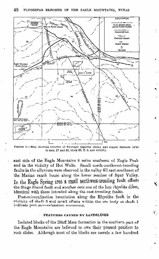
48 FLUORSPAR DEPOSITS OF THE EAGLE MOUNTAINS, TEXAS
FIGURE 4. Map showing locution of fluorspar deposits (dots) and copper deposits (x's)- in sees. 37 and 48, block 68, T. 9, and vicinity.
least side of the Eagle Mountains 8 miles southeast of Eagle Peak and in the vicinity of Hot Wells. Small north-northwest-trending faults in the alluvium were observed in the valley fill east-southeast of the Marine ranch house along the lower reaches of Spar Valley.In the Eagle Spring area a small northwest-trending fault offsetsthe Stage Stand fault and another cuts one of the late rhyolite dikes,, identical with those intruded along the east-trending faults.
Post-mineralization brecciation along the Rhyolite fault in the vicinity of shaft 3 and small offsets within the ore body at shaft 1 indicate post-mineralization movement.
FEATURES CAUSED BY LANDSLIDES
Isolated blocks of the Bluff Mesa formation in the southern part of the Eagle Mountains are believed to owe their present position to rock slides. Although most of the blocks are merelv a few hundred

GEOLOGY 49
feet or less in outcrop diameter, two are much larger. One of these larger blocks is in the Kocky Ridge area on Snowline Kidge and the other is about one-half mile east of Cottonwood Canyon. The block at Rocky Ridge crops out on the crest and northwest slope of Snowline Ridge. It is about 150 ft thick and crops out over an area ab6ut one-half mile long by one-fourth mile wide. To the south and south east it has been eroded away, and to the northwest it dips about 30° under the overlying lavas. The block east of Cottonwood Canyon crops out on the nose and both sides of a narrow ridge. It is about 100 ft thick or perhaps slightly more and dips about 10° NE. beneath the lavas. It has been eroded away on the other three sides. Both blocks are overlain and underlain by rocks of the upper rhyolitic series. The block in the Rocky Ridge area.is about iy2 miles northeast of the nearest Bluff Mesa formation cropping out in normal position at the western base of the mountain, and is about 1,500 ft higher in altitude. The block east of Cottonwood Canyon is even farther away and at a greater altitude.
All of these isolated blocks of the Bluff Mesa formation are be lieved to be landslide blocks that have slid into their present position from places above the now-covered folded Devil Ridge thrust fault on the southwest limb of the syncline. Woodford and Harris (1928) describe a similar landslide block from the San Bernardino Moun tains of southern California. On the northeast side of the syncline,. wherever the Devil Ridge thrust is not covered by the Tertiary vol canic rocks, the Bluff Mesa formation rests directly upon the Eagle Ford formation and is in thrust fault contact with it. This relation ship may also have existed on the now-covered southwest limb of the syncline. At some time during the outpouring of the upper rhyolitic series large masses of the Bluff Mesa formation may have become detached, owing in part to the weak nature of the underlying shale of the Eagle Ford formation, and slid down the mountainside as large blocks. These blocks came to rest on rocks of the upper rhyolitic series and then were partly or completely buried by later rocks of this same series. The igneous activity and accompanying tectonic dis turbances may have acted as a trigger mechanism to start the blocks of the Bluff Mesa formation sliding. Erosion since has stripped off some of the overlying volcanic rocks.
The block at Rocky Ridge, which was studied in detail because of the fluorspar deposits, consists of brecciated limestone and sandstone, the fragments of which are still largely in their original position. Bedding, and textural and compositional features can be followed for as much as 100 ft. The crackled and crushed appearance of the rock, however, is in great contrast to the overlying and underlying volcanic rocks which are not brecciated or fractured except in the

50 FLUORSPAR DEPOSITS OF THE EAGLE MOUNTAINS, TEXAS
vicinity of faults. Many faults cut the sedimentary rocks, and no unit can be followed for more than a few hundred feet. Silicification, fluoritization, and recrystallization, due largely to hydrothermai solu tions, were facilitated by the crushed and crackled condition of the beds. The intrusive appearance of the basal contact of the sedi mentary block with under lying, volcanic rocks may be due to mechani cal brecciation of the basal part of the block and recementation by hydrothermai solutions. The lava, however, may have been semi- molten when the sedimentary block came to rest upon it, and the semi- molten material may have been forced into some of the many cracks at the base of the sedimentary block. The silicic material now filling the fractures at the base of the sedimentary block may have been stringers and apophyses of rhyolite, now completely silicified and recrystallized, or they may be hydrothermai silicic fillings.
GEOLOGIC HISTORY
The sequence of events in the Eagle Mountains area before the deposition of the Cretaceous sediments can only be surmised from incomplete and fragmentary records in the area, but it was probably much the same as in the rest of trans-Pecos Texas. With the begin ning of Cretaceous time, however, the sedimentary and tectonic rec ords are more nearly complete and can be studied in more detail. The probable record of events is as follows:
1. The pre-Cambrian deposition of sediments was followed by one or more periods of uplifting and intense deformation during late pre-Cambrian time and the intrusion of igneous rocks.
2. During the Paleozoic era the seas probably covered much of the area, Subsequent erosion removed most of the Paleozoic sedimentary rocks previous to Permian time, so that rocks of Permian (?) age rest directly on the pre-Cambrian rocks. The Permian seas probably covered most of the area, and sediments were laid down on a rela
tively flat surface. t3. Uplift and erosion followed the deposition during Permian time",
and during the early part of the Mesozoic era the Eagle Mountains area was dry land,
4. During the Cretaceous period marine sediments Were deposited, Starting With the clastic sediments of early Trinity time, probably de-
rived from highlands to the nOlM Rlld W6St, and continuing through
out the Early CretaCeOUS epoch and through Eagle Ford time of the Late Cretaceous epoch, without great interruptions. The latOF SGdl'
rOCkS ale predominantly limestones, indicating deeper waters
clearer seas, Deposition may have continued after Eagle Ford time, but if so, the later sedimentary rocks have been removed from the area, and no record of them has been found. Baker (1927, p. 31),

GEOLOGY 51
however, records sedimentary rocks, which he assigns doubtfully to the Taylor marl, as occurring "near the'middle of the outer north eastern flank of the southern Eagle Mountains," probably just south east of the old Taylor ranch house and 8 to 10 miles southeast, of Eagle Peak.
5. After the deposition of the Upper Cretaceous sediments, the area was uplifted, folded into low gentle folds, and thrust from the southwest. This earliest age of thrusting and uplifting probably was a part of the Laramide revolution of western North America.
6. Volcanic activity began in early Tertiary time and probably continued well into Miocene and possibly Pliocene time. In the Eagle Mountains the Tertiary igneous activity started with the deposition of a great thickness of tuffaceous sediments and volcanic breccias of rhyolitic composition. Interbedded with these pyroclastic rocks are many rhyolite flows. Rhyolite sills invaded the sedimentary rocks near the margins of the vents. More mafic types of rock, including flows and some pyroclastics of andesitic and trachytic composition, followed the rhyolitic tuffs. After a period of quiescence during which much of the trachyte porphyry was removed by erosion, a second period of volcanic activity resulted in the formation of the great thicknesses of lava flows, ranging in composition from rhyolitic through andesitic, which comprise the upper rhyolitic series. Little pyroclastic material is present in this series, but flow breccias thai include numerous fragments of foreign rock types are common.
7. Following this igneous activity, and probably contemporaneous with at least the latter stages of it, the area was folded into a syncline or basin. This may have been associated with a corresponding doming of the area of pre-Cambrian rocks to the northeast.
8. Faulting with a northeast trend was associated with the folding and doming of the pre-Cambrian rocks. Thrusting from the south-
. west closely followed or was associated with the- deformation. This thrusting is well exhibited in the Van Horn Mountains and the Tierra Vieja, about 25 miles southwest of Eagle Peak. It may be repre sented in the Eagle Mountain area by the Spar Valley fault.
9. The intrusion of the syenite stock (Eagle Peak syenite) may have immediately followed the extrusions or may have occurred after the folding and normal and reverse faulting.
10. Renewed faulting occurred in the area, this time in two direc tions, roughly northwest and east. The east-trending faulting is definitely later than the intrusion of syenite.
11. The intrusion of mafic dikes may have occurred any time after the folding and accompanying faulting, and before the late faulting and fluorspar mineralization.
12. Late rhyolitic dikes were intruded along some of the fault planes, principally those trending east.

52 FLUORSPAR DEPOSITS OF THE. EAGLE MOUNTAINS/ TEXAS
13. Two stages of fluoritization are present, although they may have been very closely spaced in time. The earlier stage appears to be the more' important, for the later fluoritization merely formed coatings and incrustations on the earlier minerals. Silicification may have occurred simultaneously with either stage, or later. One stage of silicification, however, may be intermediate in time between the two stages of fluoritization. Albitization of the volcanic rocks and the syenite probably occurred about the same time as fluoritization or slightly later.
14. Late faulting, cutting the late Cenozoic basin deposits and the valley fill, followed fluoritization. This period of faulting may have been accompanied by an uplift and slight rejuvenation of the area, because two stages of valley deposition and stream erosion are present.
15. Continued erosion and deposition along the stream valleys and in the intermontane basins have produced the present topography.
MINERAL DEPOSITS
LEAD, ZINC, COPPER AND SILVER DEPOSITS
Old copper, lead, and zinc workings are present on the northeast side of the Eagle Mountains in the area underlain by the pre-Cambrian Carrizo Mountain schist. They occur in small northeast- and north- trending veins in close proximity to the large east-trending Khyolite fault. The two principal workings consist of adits driven into the hillside. The prospects have long been abandoned, and no informa tion was obtainable about the mineralization. A recorded shipment of zinc ore from the Eagle Mountains in the first decade of the twen tieth century probably came from these deposits. They were again opened in 1928, but no record of any shipment of ore after that year is available.
Near the mouth of Spar Valley, in the northeastern part of sec 48, block 68, T. 9, (pi. 2 and fig. 4), a pit about 20 ft deep has been sunk on a small quartz vein occurring along a fault between the Eagle Ford formation and rhyolite of the lower rhyolitic series. Azurite,
malachite, and a Me C.klcOCltG are pIOTt, About 5 tons of Copper ore was shipped from this prospect in the early 1920's.
On the southwest side of the mountains, lead, zinc, copper, and silver minerals occur at the Black Hill deposit (Dick Love mine) (Sellards and Baker, 1934, p. 572), the Silver Eagle d&posit, and adjacent prospects (pi. 2). The Workings at the Black Hill deposit are inaccessible at present., but they are said to be extensive. They consist of two shafts and an adit. The deposit is along a steeply dipping fault striking N. 35° W. within the Bluff Mesa formation. Other shafts are present in the vicinity. Several carloads of lead ore

MINERAL DEPOSITS 53
containing 1,000 to 1,600 oz of silver and some gold was shipped from the-Black Hill property in 1923 (Henderson, 1927, p. 609).
The Silver Eagle deposit, mined for its lead and silver content, is at the foot of the western slope of the mountains where the gravels of the valley fill lap upon the bedrock. The deposit was discovered in June 1940 by A. J. Nassamer of the Yodina Mining Co., which shipped 66 tons of ore to the El Paso smelter by November 1940. Production had not been resumed by 1947. In 1943 and 1944 the U. S. Bureau of Mines trenched, drilled, and sampled the deposit for zinc (Dennis, 1946). Two shafts, Shaft 1, 60 ft deep and dipping 65° S., and Shaft 2, a vertical shaft 32 ft deep, and numerous trenches explore the vein (fig. 5).
The vein dips about 65° S. 5° E. and is along the Silver Eagle fault, which may be the western extension of the Wind Canyon fault or may be a smaller parallel fault. Limestone of the Bluff Mesa forma tion is present on the north or footwall side of the vein and valley fill on the south side, but at a depth of 15 ft in shaft 1 limestone of the Bluff Mesa formation is present on both sides of the vein. The vein averages 4.5 ft in width and has been traced for 250 ft along the strike. Drill holes have cut the vein at a depth of 180 ft down the dip of the vein from the outcrop. The ore consists primarily of hemimor- phite, calcite, and quartz, but cerussite, galena, sphalerite, malachite, .and silver also are present.
A shaft sunk on a vein near the mouth of Snowline Canyon, about one mile east of the Silver Eagle deposit, is inaccessible at present :and filled with water. Specimens taken from the dump contain .galena, sphalerite, hemimorphite, chalcopyrite, calcite, and quartz. The vein occurs in diabase, probably along a continuation of the Silver Eagle fault.
COAL
Small coal seams are interbedded with the steeply dipping black shales of the Eagle Ford formation in the Eagle Spring area (pi. 2). The deposits were opened in the late 19th century and are at present inaccessible. Sporadic attempts have been made to work the coal during the past 50 years, the last being about 1927. The principal workings are in Coal Mine Arroyo. According to Baker (1927, p. 67) these consist of a shaft 200 ft deep with levels at 100 and 200 ft. The coal is semianthracite, and specimens collected from the dump appear hard and fresh despite having been exposed to the weather for many years. Considerable ash remains upon burning, however. The maximum width of any seam reported is 3 ft.
FLUORSPAR
Fluorspar is present in the Eagle Mountains as both bedding- replacement deposits and as fissure veins. The replacement deposits

54 FLUORSPAR DEPOSITS OF THE EAGLE MOUNTAINS, TEXAS
Modified from U.S. Bureau of Mines 53 oi , , , , i
150 Feet
Contour interval 10 feet Datum assumed
EXPLANATION
Bluff Mesa formation
Fluorspar vein
10 0 50 Feet
Contact, dashed where approximately located!
Fault, showing dip; dashed where approximately located
0 Shaft
U. S. Bureau of Mines trench
o -U.S. Bureau of Mines
diamond-drill hole
FIGURE 5. Plan and section through drill holes showing the analyses of samples from trenches and drill holes, Silver Eagle deposit, Eagle Mountains, Hudspeth County, Tex.
are in limestones and sandy limestones. TK© fissure veins occur prin-
Cipally in rhyolitS, but m fflftny-places CUt the sedimentary rocks.
The COUntry rock next to the walls of the veins IS locally I$plftC6(l
TvKere the veins are in limestone. BeplaCeHieilt Of fault gouge and
breccia has also taken place,The diversity in local geology of the various deposits and in Struc
tural and chemical control of the fluorspar concentration necessitates individual descriptions of each deposit. The mineralogy of the de-

MINERAL DEPOSITS 55
posits and the origin of the fluorine-bearing solutions, however, are similar througout the Eagle Mountains and can be discussed on aregional basis.
HISTORY AND OWNERSHIP
With the exception of the Eagle Spring deposits and the Tank Canyon deposits, all known fluorspar deposits in the Eagle Mountains were, as of 1948, on claims owned by the Texas Fluorspar Mines, Inc., or on land owned by Fraser, Burr, and McAlpine, of Dallas, Texas, a holding subsidiay of the Texas and Pacific Land Company, and leased to the Texas Fluorspar Mines, Inc. Koy F. Hickman of Van Horn, Texas, is president of the Texas Fluorspar Mines, Inc. The Eagle Spring deposits are on claims owned by J. J. Trepannier, and the Tank Canyon deposits on claims owned by Frank Sanchez, both of Sierra Blanca, Tex. (see pi. 3.)
The earliest discovery of fluorspar in the Eagle Mountains was made in 1919, when J. A. McDonald staked a claim and dug two small pits on the sites of trenches F and I (pi. 10) on the North ore body in Spar Valley. No further work was done until 1942, when V. B. Melton of El Paso, and J. R. Kennedy of Hot Wells leased the property from the owners, Fraser, Burr, and McAlpine. The lessees sank a shaft,>the "old shaft," on the North ore body, to a depth of 20 ft and also mined fluorspar from an open cut and small adit, the site of the present trench C. Fluorspar was taken also from an adit at the old Red Pit locality, the site of present trench M. A total of 200 tons of fluorspar was shipped to the custom mill at Deming, N. Mex.
In March 1943 the Texas Fluojite Company, represented by Philip S. Hoyt of Van Horn, Tex., took .over the lease and brought the prop erty to the attention of the U. S. Bureau of Mines. Trenching and drilling was begun by the Bureau of Mines in June 1943 and con tinued until February 1945. Twenty-three diamond-drill holes, total ing 2,631 ft, were put down, and 83 trenches, totaling 2,379 ft of excavation, were completed. After the early results of the drilling and trenching indicated a sizable fluorspar body, the State of Texas built an access road to the locality from Hot Wells.
In October 1943 the property was sublet to the Western Fluorite Company, controlled b}^ the J. E. Ingram Construction Company of San Antonio, Tex. New leases were made with Fraser, Burr, and McAlpine for the whole of sees. 35, 37, 27, and other odd-numbered sections. Many old claims were bought and new ones were staked, so that most of the fluorspar deposits were under the control of the Western Fluorite .Company.
Development work was begun on the Spar Valley deposits in the summer of 1943, and Shaft 1 was sunk on the main fluorspar body

56 FLUORSPAR DEPOSITS OF THE EAGLE MOUNTAINS, TEXAS
to a depth of 200 ft. The fluorspar body was crosscut, and drifts were extended north and south on the 80-ft and 200-ft levels. Other fluorspar deposits. were discovered in the vicinity, and Shafts 2, 3, and 4 were sunk on veins. Development work was also begun on the deposit in sec. 2Y (pi. 8 and fig. 9) and on several other deposits.
In September 1944 construction was started on a 50-ton flotation mill which was put into operation in the fall of 1945. During the latter part of 1945 and early in 1946 acid-grade spar was produced sporadically by the mill, but operations were unsatisfactory and ship ments from the mines were almost entirely confined to metallurgical spar.
In August 1946 the Western Fluorite Company sold the mill and all its fluorspar properties, including the leases with Eraser, Burr, and McAlpine, to'Joseph Glassberg and Leon Glassberg of San Antonio, Tex. The new owners started operations immediately as the J. and L. Fluorite Company, with main offices in the Transit Tower Build ing, San Antonio, Tex. Mining was continued in shaft 1, and develop ment work was resumed on the shaft 4 deposit. Changes were made in the mill to enable the operators to produce ceramic-grade spar. In April 1948 the J. and L. Fluorite Company sold all its holdings to the Texas Fluorspar Mines, Inc. This company was successfully operating the mines and mill, producing principally ceramic-grade spar, in 1950.
Fluorspar was first shipped by the Texas Fluorite Company in November 1943, and by October 1945 when the mill was first put into operation, the Western Fluorite Company and its predecessor had shipped approximately 8,450 tons of metallurgical-grade fluorspar to eastern steel mills. From October 1945 to January 1949, a totalof about 2,750 tons of fluorspar, mostly acid and ceramic grade, were shipped by the Western Fluorite Company, the J. and L. Fluorite Company, and Texas Fluorite Mines, Inc. Thus a total of about 11,400 tons of fluorspar was shipped from the mines at Spar Valley
between 1942 and January 1949.In the spring of 1943, the deposits at Eagle Spring (pis. 2 and 7)
were opened up by the Eagle Spring Syndicate, of which. E. K. Parks of Sierra Blanca, Tex., was president. About 600 tons of metallur gical-grade fluorspar, averaging 70-82 percent of CaF2 , was shippedto the Continental Ore Company of Chicago, 111. Milling was dis continued when the grade of the fluorspar became too low. In thespring of 1944, the U. S. Bureau of Mines excavated two trenchesand sampled the deposits. The results indicated tlia.t the deposits
were of too low a grade to be of economic importance,The Eocky Eidge deposits were discovered in November 1943 by
Eicardo Sanchez. In December 1943, a few small pits were

MINERAL DEPOSITS 57
vated by the U. S. Bureau of Mines on one of the veins, and further trenching and sampling were done in July 1944 (pis. 2 and IT). No fluorspar had been shipped from these deposits by June 1950.
MINERALOGY
Fluorite is the principal mineral in both the fissure vein and bed ding-replacement types of deposits. Calcite is present in the replace ment fluorspar deposits and in the fluorspar veins where the wall rock is limestone. Ankerite fills cavities in the bedding-replacement de posits of the North ore body. Quartz, either as chalcedony or as coarse crystals, is found in all deposits, and small amounts of pyrite, hematite, and limonite also occur. Smithsonite (zinc carbonate) has been reported associated with the fluorspar at Eagle Spring (Evans, 1943, p. 8).
Malachite, azurite, cerussite, hemimorphite, galena, chalcocite, and sphalerite, although present in the small copper, zinc, and lead-silver deposits on the northeastern and western sides of the Eagle Mountains, are not found associated with the fluorspar. Sulfide minerals and barite, so common in many of the fluorspar deposits of the Western States, are absent.
FLUORITE
The fluorite is commonly green, but white, yellow, blue, violet,, and deep purple varieties occur. Color banding is common in some of the crystalline masses in the veins and small open-space fillings,, especially at the North ore body in Spar Valley and at the Fox claim 4 deposit. The purple and dark-green fluorite is surrounded by distinct zones of lighter green and white fluorite. Excellent crystals occur in most of the deposits. Small green cubes line the open spaces in the North ore body, and both large and small cubes are present in the deposits in the Rock}^ Ridge area. Large crystals as /much as 3 in. in diameter, with curved faces, are found at the Fox claim 4 deposit. Acicular and fibrous varieties, showing cubic jfaces; on the ends of the needles and fibers, are present at the Fox claim 4 and the Syphon Canyon deposits.
Fluorite of two ages is present in the deposits. At the deposit on Fox claim 1 dark-green octahedral crystals of fluorite are completely encased in light-green fluorite cubes (see pi. 62?). A similar indica tion of two ages of fluorite is present at the North ore body where small nuclei of dark-green octahedral fluorite are encased in the lighter- green fluorite, which also fills the spaces between .the early fluorite (see pi. 6A). At this locality, the later fluorite also forms small honey-colored fibrous masses, and it is probable that the fibrous and concretionary fluorite at the Syphon Canyon and Fox claim 4 deposits; belong to this latter stage of fluoritization.

58 FLUORSPAR DEPOSITS OP THE EAGLE MOUNTAINS, TEXAS
The Fox claim 4 deposit contains some extremely dark-purple well- crystallized fluorite which, when freshly broken, momentarily emits a penetrating odor, probably caused by entrapped fluorine reacting with moisture to form ozone.
QUARTZ
Quartz is present in the bedding-replacement deposits as sand grains remaining from the incomplete replacement of the original sandy limestone and as recrystallized quartz intimately associated with the fluorite. Later coatings of drusy quartz line the cavities. In the fissure veins, quartz occurs as distinct crystals or as chalcedony and chert.
CALCITE AND ANKERITE
In the replacement deposits, calcite is present as an integral part of the ore and also as vein and cavity fillings. Small grains of calcite are disseminated throughout the ore where replacement has been in complete. Coarsely crystalline calcite is locally abundant in veins and cavities in the replacement deposits and formed after the fluorite and the quartz. The calcite is normally colorless or amber colored. In the North ore body reddish-brown ankerite with curved crystal faces occurs. The ankerite is particularly abundant just north of the raise (see pi. 13) in the lower levels of the mine. The amber- colored calcite commonly contains inclusions of ankerite.
In the fluorspar veins, calcite is uncommon except where the wall rock is limestone. Veins of pure calcite are present throughout the area, some being 20 ft wide. They are usually found in the sedinib.^-tary rocks but some extend through the associated dikes and sills.
In the deposit on Oak claim 4 white calcite, associated with thefluorite, forms euhedral hexagonal tabular crystals.
X.IMONITE, HEMATITE, AND PYB.ITE
Limonite and hematite usually in association with ankerite arepresent as minute coatings and incrustations in the North ore tody.Thin coatings and films of limonite are associated wmi dark pUTplG fluorite at the Fox claim 4 deposit. Hematite and limonite occur in very minor amounts in the fluorspar veins in the Rocky Ridge area,in the Rhyolite vein, and elsewhere. Small pyrite crystals are asso ciated with some of the veins in rhyolite.
SMITHSONITE
Smithsonite is found associated with fluorspar as a white crust onthe hanging wall of one of the adits of Eagle Spring. Elsewhere inthe Eagle Spring area it IS present in small amounts and is not asso ciated with fluorspar.

GEOLOGICAL SURVEY BULLETIN 987 PLATE 6
f
FLUORSPAR SPECIMENS FROM THE EAGLE MOUNTAINS, HUDSPETH COUNTY, TEXAS
A, Fluorspar from the North ore body, Spar Valley, showing dark-green early fluorite encased in light- green late fluorite; B, fluorspar from pit on Fox claim 1, showing cubes of light-green late fluorite en casing octahedra of dark-green early fluorite.
MINERAL DEPOSITS 59
ORIGIN AND PABAGENESIS
The association of fluorite with alkaline igneous rocks is of common occurrence. Smyth (192T, p. 555) mentions that a characteristic and perhaps the most distinctive element in the alkaline magmas is fluorine, and Lindgren (1933a, pp. 163-164) notes the concentration of fluorite occurrences in the western United States and Canada in the regions of alkaline rocks. The genetic association of fluorite with phonolite and other alkaline intrusives at Cripple Creek, Colo. (Lind- gren 1933b, pp. 492-493), and with syenite at the Rock Candy fluor spar deposit (Dolmage, 1929, pp. 22-28) in British Columbia are note worthy examples.
In the Eagle Mountains the presence of the stock of Eagle Peak syenite, which was intruded in late Tertiary time and around which the fluorspar, deposits are concentrated, is in conformity with this principle. Although the fluorspar actually was observed within the syenite at only one localitj^, the proximity of the rest of the deposits to the syenite suggests a genetic relationship. The fluorine-bearing solutions represent a very late stage of the intrusive activity, because enough time must have elapsed before the emanations of the mineraliz ing solutions from the parent magma for the upper parts of the syenite stock to cool, solidify, be disturbed by faulting, and perhaps be partly denuded by erosion. The extensive silicification and al- bitization of the Eagle Peak syenite and the volcanic rocks through out the mountains by'alkalic solutions were probably associated with the fluoritization.
The many large faults of the Eagle Mountains facilitated the rise of these solutions and account for the wide, distribution of the fluor spar deposits and the widespread albitization. In particular, the large east-trending faults with their wide breccia zones acted as major channels from which the solutions spread into the many northeast- trending faults and fractures and into the replaceable limestone beds. As the solutions rose along the faults, they reached places where con ditions of temperature', pressure, and chemical composition of the country rock were conducive to the precipitation of fluorite. Any hydrofluoric acid present probably reacted with the wall rock to pro duce additional fluorite. Where the country rock was limestone, ex tensive reactions formed the. large replacement deposits. Where rhyolite was the wall rock, only slight replacement occurred, and open-space filling was the dominant process. Nowhere were any veins found cutting the sandstones and quartzites, and it is improbable that any extensive replacement of these rocks occurred.
The simplicity of the mineralogy of the deposits makes the prob lems of paragenesis relatively simple. Except for the syngenetic
219618 53 5

60 FLUORSPAR DEPOSITS OF THE: EAGLE .MOUNTAINS, TEXAS.
calcite and quartz in the original sandy limestones of the replace ment deposits, fluorite was the earliest mineral deposited. Two stages of fluoritization are clearly shown by the two ages of fluorite at the North ore body, the Fox claim 1 deposit, and elsewhere. Whether the second stage immediately followed the first is not known. There is no positive indication of any other type of mineralization, or any faulting, igneous activity, or other type of disturbance occurring between the two periods of fluoritization. Probably they were rather closely spaced in time. In the deposits on Fox claim 1, however, no drusy quartz coatings were found on the later, lighter-colored fluorite, and it is possible that the drusy quartz at this locality was deposited on the dark green fluorite before the deposition of the later fluorite. Both types of fluorite occur within the east-trending faults, .and small crystals adjacent to the gouge of the high-angle fault on the 200-ft level in the North ore body indicate that at least one of the stages is later than this fault.
In the replacement deposit of the North ore body, a reduction in volume of the host rock was attendant to the formation of the CaF2 from the CaCO3 of the limestone. Bacause the specific volume of CaF2 is only two-thirds that of CaCO3 , however, the stoichiometric volume change required by the following reaction (Schwerin, 1928, pp. 336, 339; Currier and Hubbert, 1944, p. 37) (assuming that the fluorine is present as HF)
2HF + CaCOs=CaF2 + H2O + CO2
would leave a greater amount of space than is present within the ore body at the present time. (See Schwerin, 1928, pp. 336, 339; Currier and Hubbert, 1944, p. 37.): Empty spaces in the North ore body were filled to a great, extent during the second stage of fluoritizatioili The later fluorite formed coatings around the individual grains and crys tals Of tile ea/rlkr fluorite and filled the interstices. It also formed
as crystals in the larger open spaces and vugS and filled tll6 Bm^ll fractures and fissures which ha.d acted as channels through the lime- StOne, The later stage of fluoritization was essentially one of open-space filling rather than of replacement, although partial solution of the earlier fluorite may have occurred.
Much of the silica and calcite in the replacement deposits repre sent material residual from incomplete replacement of the originalsandy limestone. SiKcification probably accompanied the early flUOritlzation ana a SCco-<a 6__ti_ Qf, a, Kca waa r)robably inter.
mediate between the two stages of fluOritotlOIL A Still later prioa of silicification resulted in the drusy quartz. The coarsely crystalline Calcite and the ankerite filled cavities formed comparatively latfi bj
the action of solutions.
,....; , - -MINERAL DEPOSITS . 61
In the Eagle Mountains a horizontal and vertical zoning of the fluorspar and the metalliferous minerals in relation to the stock of the Eagle Peak syenite is suggested. A definite conclusion can be reached only after a much more extensive study. Lead, zinc, copper, and silver minerals occur in small deposits on the north, northeast, east, and south sides of the Eagle Mountains. 'With the exception of the Eagle Spring locality, at no place have the fluorspar and the^ metalliferous minerals been found together. The fluorspar occurs in the central, higher portions of the mountains, and the metalliferous minerals occur at lower altitudes and at greater distances from the central stock; At Eagle Spring small amounts of smithsonite (Evans,
0 1943, p. 8) are associated with the fluorspar, but this deposit is at an. intermediate distance from the stock and is at a low altitude.
Although the metalliferous deposits on the northeast side of the mountains are within the pre-Cambrian rocks, those on the north, east, and south sides are within the Cretaceous sedimentary rocks. Nowhere in the area have the metalliferous minerals been found within the volcanic rocks. In the extreme northeast corner of sec. 48 how ever, a small copper deposit occurs in a fault very close to rhyolite; and on the southwest side of the Eagle Mountains near the mouth of Snowline Canyon lead-zinc ore was mined from an old shaft in a; diabase dike cutting volcanic breccia of the lower rhyolitic series. Thus it appears that the metalliferous minerals were deposited after the extrusion of the volcanic rocks and belong to the same general stage of mineralization as the fluorspar.
STRUCTURAL AND STRATIGRAPHIC CONTROL, OF ORE BODIES
The structural control of ore bodies in the Eagle Mountains is ob vious. The fissure veins occur within the east-trending fault zones or within faults and fractures trending northeast and near the east- trending faults. The replacement deposits in the Kocky Eidge area are associated with northeast-trending faults, and the deposits in sees. 37 and 48 occur in the vicinity of the east-trending Wind Canyon fault. At Spar Valley the proximity of the east-trending Rhyolite fault accounts in part for the localization of the replacement de posits of the North and South ore bodies. The many east and north- cast-trending fractures and small cross faults in the area acted as subsidiary channels and the Mine fault and the larger northeast- trending faults were factors that limited the extent of the fluoritiza- tion. It is significant that although the northwest-trending faults antedate fluoritization, they contain no fluorite except in minor amounts. Small stringers and crystals of fluorite are found in the gouge of the Mine fault on the 200-ft level of shaft 1, but the fault acted as a dam rather than as a channel for the fluorine solutions.

62 FLUORSPAR DEPOSITS OF THE EAGLE MOUNTAINS, TEXAS
The open, east-trending faults, with wide breccia zones, ^were the major channels for the solutions, and the northeast-trending faults were the subsidiary channels.
In addition to the clear structural control of the fluorspar deposits in the Eagle Mountains, the tendency of the ftuorite to be associated with certain rock types and stratigrapnic units'is'marked; Fissure' veins occur throughout the sedimentary series and in all the igneous rocks except the diabase dikes, but fluoritization, appears to be greater and the veins more persistent and wider where the wall rock is rhy- olite, syenite, or limestone. The replaceable beds appear to be con fined to three units: the Bluff Mesa formation, the Finlay limestone, and the reef-limestone member of the Grayson formation. Of the three, the beds in the Finlay limestone appear to be the best host rock.
At the Rocky Ridge and Eagle Spring deposits, limestone of the Bluff Mesa formation is the host rock, the beds replaced being associ ated with and interstratified with beds that contain abundant rudistid remains and Orbitolina. At the North and South ore bodies in Spar Valley, and probably at the Lucky Strike deposit, the replaced beds are in the upper part of the Finlay limestone immediately above the uppermost Toucasia reef beds. At the deposit ; in sec. 27, and also at the deposits about 400 ft west of the South ore body in Spar Valley, the reef-limestone member of the Grayson formation is the replaced unit. It is probably significant that all these beds are extremely fossiliferous and composed largely of small shell fragments. All are in zones within which remains of the reef-making pelecypods compose much of the rock. All are distinctly granular, as compared to the dense black limestones of much of the stratigraphic section.The presence of similar but unreplaced beds at other levels within the Bluff Mesa formation and the Georgetown limestone indicates that other factors were also involved in the selection of replaceable beds.
DESCRIPTION OF WORKINGS
The following descriptions Of the workings are taken up in geo
graphic order, starting at the north side of the mountains aid: COn- tinvjing cloclcvvise aroxind the mountains. As of June 1947 the work-ings at the various deposits in the area were as follows:
EAGLE SPRING
TWO cldltS hclVe been driven on separate fluorspar bodies «,t> Eu,gie
Spring. The North adit extends westward for 124 ft and dips 15°.
The South adit extends westward for 105' ft and dips 11°. The MitStlYGrotfTO 0 ft ill Width and about 4.5 ft in Height. A few trenches
have been excavated along other parts : of the vein (pi. 7).

DESCRIPTION OF WORKINGS *> 63
SEC. 27
A vertical shaft has been sunk on the deposit in sec. 27 to a depth oi 30 ft, and a drift was extended 30 ft to the west (fig. 9).
NORTH ORE BODY, SPAR VALLEY
An open cut and a 20-ft-deep vertical shaft constitute the old workings at the North ore body in Spar Valley. Recent workings consist of a shaft sunk along the dip of the ore beds to a depth of 200 ft, with levels at 80 ft and 200 ft. Drifting on the 80-ft level extends 30 ft north and 130 ft south of the shaft. Two crosscuts were made to the uppermost ore bed, and drifts were driven along that bed. On the 200-ft level drifts in the lower ore bed extend south of the shaft for 180 ft. Many stopes and raises which are not shown on the under ground map (pi. 13) have been excavated.
SOUTH ORE BODY, SPAR VALLEY
No underground workings are present at the South ore body. The old adit, known as the Red Pit, is now a part of trench M (pi. 10).
RHYOUTE VEIN, SPAR VALLEY
Shaft 2 has been sunk to a depth of 150 ft on the Rhyolite vein. Drifting on the 80-ft level extends 65 ft east and 77 ft west of the shaft. On the 150-ft level the drifts extend about 28 ft east and 88 ft west of the shaft (fig. 6). Shaft 3, situated 1,900 ft east of saft 2, is 45 ft deep. At the 30 ft level a drift extends west from the shaft for 30 ft. A small adit, 600 ft west of shaft 2, extends west for 25 ft along the vein. An open cut is present about midway between shafts 2 and 3.
SHAFT 4
Shaft 4 has been sunk to a depth of 45 ft, but no drifting has been done from this shaft. An adit has been driven 175 ft into the side of the hill below and to the north of the shaft, and a drift extends 125 ft southwestward from the adit along the vein. Some stoping has been done (pi. 15).
OTHER WORKINGS
Exploratory trenching has been done on the deposits in the Rocky Ridge area, on the Lucky Strike deposit, and on the deposits on Fox claim 4, Fox claims 1 and 3, Fox claim 10, Tank Canyon claim lr Syphon Canyon claim, and on sec. 45 (pis. 9 and 17 and figs. 7 and 8).

64 FLUORSPAR DEPOSITS OF THE EAGLE MOUNTAINS, TEXAS
EXPLANATION
Inclined shaft going above and below level
. .- -KlBottom of shaft
Compass and tape mine survey byH.E.ROtfirocKanflOliOTOiliermon
Geology by H. E. Rothrock andElliot Gillermdn, 1944-45
JTiatrum 6. -Composite level map, shaft 2, Rbyolite vein. Spar Valley fluorspar deposits. Eagle Mountains, Hudspetli County, Tex.

^
' "-
." ' '"''' '-'','' -','-* '',
', /V
~ V
' ',','£.-''-
" '-' '
'. '',Y
--'-' V
-"
v
' - '' A
' ' ''A
'/'*'-
1-"
' ''/'"-''
-. -'-
'I ,-
.'.-,
' i '
s - "
,'-
>s -
,''.-'
--'
' r..'
_".',
, - -
«,'-
,< /
/.
> - -
"-'.
.\"
,.'/'.''J
v/'
EX
PLA
NA
TIO
N
Gra
yson
for
ma
Eagl
e M
ount
ains
san
dsto
ne m
embe
r
Fluo
rspa
r, sh
owin
g or
e w
idth
.in f
eet
and
perc
ent o
f CaF
2
Con
tact
das
hed
whe
re in
ferr
ed
Faul
t, da
shed
whe
re in
ferr
ed
i»o
Stri
ke a
nd d
ip o
f be
ds
U.S
. B
urea
u of
Min
es t
renc
h
Dum
p
Und
ergr
ound
wor
king
s
CO o a § o » B !2J
O
CO
Geo
logy
ond
to
pogr
aphy
by
Elli
ot
Gill
erm
an,
Mar
ch 1
945
Cont
our i
nterv
al 10
feet
FIG
DH
E 7.
Geo
logi
c m
ap
of
Fox
cl
aim
4
fluo
rspa
r d
epos
it;
sec.
48,
E
agle
M
oun
tain
s,
Hu
dsp
eth
C
ount
y,
Tex
.
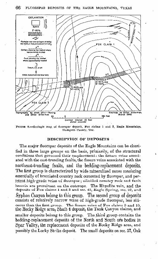
66 FLUORSPAR DEPOSITS OF THE EAGLE MOUNTAINS, TEXAS
Fluorspar vein and stringers showing ore width, in feetand percent of CaFj
Topography by Chao Chia-Hsiang and Elliot Glllerman
150
Geology by Elliot Glllermon.March .1946
Feet
Contour interval \0 feet Datum assumed
FIGURE 8. Geologic map of fluorspar deposit, Fox claims 1 and 3, Eagle Mountains,Hudspeth County, Tex.
DESCRIPTION OF DEPOSITS
The major fluorspar deposits of the Eagle Mountains can be classi fied in three large groups on the basis, primarily, of the structural conditions that governed their emplacement: the fissure veins associ ated with the east-trending faults, the fissure veins associated with the
northeast-trending faults, and the badding-replacement deposits. The first group is characterized by wide mineralized zones consisting essentially of brecciated country rock cemented by fluorspar, and per-ifitent high-grade Yeins of fluorspar 5 silicified country rock and fault
breccia are prominent on the outcrops. The Rhyolite vein, and the deposits of Fox claims 1 and 3 and sec. 45, Eagle Spring, sec. 27, and
Syphon Canyon belong to this group. The second group of deposits consists of relatively narrow veins of high-grade fluorspar, less sili ceous than the first group. The fissure veins of Fox claims 9 and 10,the Rocky Ridge area. Shaft 1 deposit, the Tank Canyon claims, andsmaller deposits belong to this group. The third group contains thebedding-replacement deposits of the North and South ore bodies in Spar Yalley, the replacement deposits of the Rocky Ridge area, and possibly the Lucky Strike deposit. The small deposits on sec. 37, Oak

DESCRIPTION OF DEPOSITS 67
claim 4, and Fox claim 4 cannot be classified in any of these major groups until explored further.
The following descriptions of the deposits are arranged in geo graphic order, starting from the north side of the mountains and con tinuing clockwise around the mountains.
EAGLE SPRING
The fluorspar deposits at Eagle Spring are in the NE*4 sec. 8 and NW^4 sec. 9, block 68, T. 9, on the northern edge of the Eagle Moun tains. They are 5^ miles due west of Hot Wells and about 5 miles N. 35° W. of Shaft 1 in Spar Valley. The parts of the deposits in sec. 8 are on the Eagle Spring claim 3, owned by J. J. Trepanier of Sierra Blanca, Tex. The main workings are 2,000 ft northwest of Eagle Spring (pis. 2 and 3).
The geology of the Eagle Spring area was studied by J. Fred Smith, Jr. (1941), and the fluorspar deposits have been discussed by G. L. Evans (1943) and by R. D. Trace (1944, unpublished).
Permian(?) strata, dipping west and southwest at low angles, are unconformably overlain by the red and brown limestones and shales of the Yucca formation of Early Cretaceous age. These in turn are overlain by the limestones, limestone-pebble conglomerates, and sand stones of the Bluff Mesa formation which contains abundant Orbito- lina texana. A. rhyolite sill locally separates the Yucca formation from the Bluff Mesa formation. Late rhyolite intrusions cut the sedimentary rocks and the rhyolite sill. They occur as dikes along the faults and as irregularly shaped bodies in the surrounding lime stones (pi. 7).
The most conspicuous fluorspar outcrops are associated with the Stage Stand fault that trends slightly north of east and is traceable for at least 3,000 ft. In most exposures the fault is vertical or dips very steeply south, but in the North adit, in the western part of the area shown on plate 7, a prominent hanging wall dipping about 70° S. is exposed. A. zone of brecciation in the sedimentary rocks, 15 to 20 ft wide, marks the fault and is particularly well exposed in Corral Arroyo. A rhyolite dike as much as 20 ft thick marks the course of the fault throughout most of its length. Displacement along the fault is not great; the south side is downthrown. This fault is dis placed northward by a cross fault west of the adits.
Another fault, subparallel to the Stage Stand fault, is present 250 ft south of the monument marking the former site of the Eagle Spring Stage Stand. Some fluorspar also occurs along this fault. Other similar faults are present.
A much later fault, trending northwest, offsets a late rhyolite dike in the north-central part of the area.

68 FLUORSPAR DEPOSITS OF THE EAGLE MOUNTAINS, TEXAS
The fluorspar occurs along the faults as fissure fillings and as re placement deposits in the limestone of the Wolf camp (?) and Bluff Mesa formations. The principal deposit is in the western part of the area and has been explored by two inclined adits. The North adit was sunk on the main fault, and in it fluorspar is exposed both as a vein along the fault and as a replacement of the gently dipping limestone strata of the Bluff Mesa formation. The vein in the adit dips 70° S. and parallels the rhyolite dike that forms the hanging wall. It is separated from the wall rock by a thick gouge, which at one point has slickensides and striations. The greatest observed width of fluorspar in the back was 18 in,, but the vein pinched out completely in a short distance. The replacement deposit is continuous with the vein and is controlled by strata that were susceptible to the mineral izing solutions. The fluorspar is within the limestone strata of the Bluff Mesa formation and is overlain by a bed of sandstone. The deposit has been mined for as much as 10 ft from the hanging wall. Mining operations stopped when the fluorspar pinched out in the lower 30 ft. of the adit. The face, which is near the projection of the cross fault, is barren.
The South adit was sunk on a bed of fluorspar on the south side of the rhyolite dike. This bed occupied the same stratigraphic zone, as did the replaced bed in the North adit. The ore averaged 1 to l 1/^ ft in thickness. At the face, 105 ft from the portal, li/^ to 2 ft of ore,, estimated to contain from 35 to 45 percent of CaF2 , is exposed. The north wall shows a soft whitish material which may be altered rhyo lite or gouge.
Fluorspar a few inches thick is exposed in a shallow pit along thefault, 700 ft east of the North adit.
In the large pit 200 ft west of the Stage Stand monument (trench A) j fluorspar is exposed in a brecciated zone 15 ft wide. The fluor
spar contains about 13 percent of CaF2 . The sedimentary rocks inthe pit are the red sandstones and shales of the Yucca formation.
In a fault south of the Stage Stand monument, a vein of fluorspar
a few inches wide was uncovered in two pits in Permian (?)limestones.
In the bed of Corral Arroyo in three small pits and a large trench(trench B) fluorspar veins *4 to 13,4 ft wide are localized along themajor fault on the north side of the rhyolite dike, (See pi. 7.) ThePermian (?) limestone is fractured for as much as 30 ft nortn of
the dike and contains stringers and small lenses of fluorspar, estimatedto have about 25 percent of CaF2 .
The prospects for finding additional tonnages of commercial fluor spar at the Eagle Spring locality are discouraging. Apparently all the fluorspar of better quality has been mined, and little remains in the-
; - . DESCRIPTION OF DEPOSITS 69
adits but low.-grade material. Samples from the trenches do not indicate any substantial tonnages of high-grade fluorspar, and the deposits themselves appear discontinuous and small.
SEC. 27
A small shaft 30 ft deep and a drift extending 30 ft west comprise the underground workings at the small deposit about 1 mile east- southeast of Carpenter Spring, in the NE^ sec. 27 (pi. 2). In trenches made by the Bureau of Mines the vein has been traced 65 ft east of the shaft.. Beginning 40 ft west of the shaft (pi. 8 and fig. 9), alluvium covers the deposit.
The fluorspar occurs along a minor fault in the rudistid reef- limestone member of the Grayson formation. Sandstones and shales of the Eagle Mountains sandstone member of the Grayson formation crop out about 30 ft southwest of the shaft. A rhyolite sill or dike is present about 50 ft southeast. The vein strikes.N. 87° E. and dips 80° S. Neither the amount not the direction of displacement of the fault along which the fluorspar occurs was measured, but the move ment has not been of great extent. The vein has been traced east as far as trench C, where 3 ft of fluorspar is exposed on the west side of the trench. No fluorspar is exposed on the east side. The abrupt termination of the vein at this place, the changes in the dip and strike of the limestone nearby, and the termination of the Eagle Mountains sandstone member of the Grayson formation against the rhyolite to the south, suggest the presence of a fault striking approximately N. 30° E., as shown on figure 9.
In the drift the fluorspar occupies a brecciated zone 5 to 7 ft wide. In.the shaft and in that part of the drift adjacent to it, the footwall is sharply defined, but the hanging wall of the breccia zone is indefi nite. At the surface a vein 1 to 1% ft thick is present 3 ft north of the footwall and separated from it by a horse of limestone. Large blocks of barren limestone are common within the fault zone. The fluorspar occurs as a partial replacement of the calcareous breccia and the adjacent wall rock. Samples taken from the shaft and from trench A show about 45 percent of CaF2 and 25 percent of CaF2 , respectively.
LUCKY STRIKE
The excavations on the Lucky Strike prospect, slightly more than half a mile northwest of shaft 1 and near the center of sec. 26 (pi. 8), were made during the exploratory work by the Bureau of Mines. They consist of a long open cut at the east end of which a shaft has been sunk 12 ft below the bottom of the open cut. A small drift extends east from the bottom of the shaft. About 30 ft of under-

70 FLUORSPAR DEPOSITS OF THE EAGLE MOUNTAINS, TEXAS
ground excavations have been .driven along the south side of the cut .(pi. 9).
Fluorspar has replaced the Finlay limestone west of the shaft, and occurs as large fluorspar boulders associated with other large boulders of dense black unmineralized limestone in a clay matrix east and south of the shaft. The boulders have not been transported far from their original source. The associated limestone occupies a strati- graphic position in the Finlay limestone similar to its position in the North and South ore bodies. A fault is present north of the deposit, and a rhyolite sill or dike terminates the fluorspar on the west. It is possible, however, that fluorspar occurs west of the rhyolite at moderate depths.
A great amount of overburden obscures the exact geologic relation ships. The nature of the fluorspar, however, and its similarity to that at the North ore body indicate possibly a bedding-replacement deposit rather than a fissure vein. Further detailed study, after additional excavation, would be necessary to determine this.
NORTH ORE BODY, SPAR VALLEY
The most important and largest fluorspar deposit in the Spar Val ley area is the North ore body. Shaft 1 has been sunk on this ore body, which is the site of most of the trenching and drilling done at Spar Valley by the Bureau of Mines. The North ore body is divisible into two parts, a north end and a south end, separated by a barren zone (pis. 12 and 13).
The North ore body is a bedding-replacement deposit Consisting oftwo or three beds of high-grade ore separated by beds of shale con taining small amounts of fluorspar. The fluorspar beds, dipping
40°-45° SW. essentially in conformity with the country rock, lieimmediately above the massive black dense Toucasia reef beds of the lower part of the Finlay limestone. They are overlain by shales and nodular limestones Of the Kiamichi formation, from which they are
separated by the low-angle branch of the Mine fault dipping essen tially parallel to the bedding. The exact stratigraphic position of the replaced limestone is not known, but it lies within the Finlay
limestone,About 200 ft down the dip of the beds from the surface OUlCTOpS
at shaft 1, the ore beds are terminated by the Mine fault, trending parallel to the strike of the beds and dipping 60°-T7° SW. Rhyolite is present west of the fault at the north end of the ore body bothunderground and on the surface but at the south end on the surface, south of trench G, the middle part Of the Georgetown limestone on the west is in fault contact with the Kiamichi formation on the east. The rhyolite immediately adjacent to the fault is silicified and very

Geo
logy
and
to
pogr
aphy
by
E
llio
t G
iller
man
, M
arch
19
45
Fluo
rspa
r, sh
owin
g or
e w
idth
, in
feet
, an
d pe
rcen
t of C
aFj
Con
tact
, sho
win
g di
p; d
ashe
d w
here
ap
prox
imat
ely
loca
ted
D
Faul
t, sh
owin
g di
p; d
ashe
d w
here
app
roxi
mat
ely
loca
ted
U;
uptA
nmm
aid
e D
; do
vmth
r&um
nd
e f3
Stri
ke a
nd d
ip o
f bed
s
CD
U
.S.
Bure
au o
f M
ines
tren
ch
\JO
pen-
cut
M I
t I
I I
Incl
ined
sha
ft at
sur
face
§ § O
fe)
*d
O 03 3 00
FIG
UR
E 9.
Geo
logic
m
ap o
f S
ecti
on 2
7 fl
uors
par
depo
sit,
Eag
le M
ount
ains
, H
udsp
etb
Cou
nty,
Tex
.B
otto
m o
f sha
ft

72
much brecciated. The breccia is composed of fragments of lime stone, quartzite, shale, and rhyolite. Fluorspar veirilets and stringers are common in the brecciated zone. The west side of the fault is downthrown with a stratigraphic displacement of at least 750 ft and a dip-slip displacement of 1,500 to 2,000 ft. This fault bends sharply northeast and then again northwest at two localities within the mine about 20 ft north of the raise and also about 20 ft north of the shaft. On the 200-ft level, the bend north of the raise appears to be the result of an offset by a cross fault. There is no evidence, however, that this structure extends into the ore bed east of the fault. North of the raise on the 80-ft level in the uppermost ore bed, this small curvature of the fault passes into a small fault, downthrown 10 ft on the south side.
. In the vicinity of trenches B, B', and G, a cross fault with the .south side upthrown forms the southern limits of the north end of the ore body. (See pi. 12). South of this fault for 90 ft, except for a small wedge of ore, the ore beds are cut out by the low-angle branch of the Mine fault, which is just above the ore beds north of the cross fault.
Owing to a slight change in direction of the strike of the ore beds, the lower part of the ore beds again is present beneath the fault about 60 ft northwest of trench I. This is the south end of the ore body. South of trench K, another cross fault offsets the ore beds, and the ore beds do not appear on the surface south of it. However, from 2 to 3 ft of ore is present in diamond-drill holes 14 and 15, and a small amount of fluorspar was reported found in drilling water wells 1 and2 (pi. 10).
East of the exposures of fluorspar in the North ore body, the Finlaylimestone is in fault contact with the Cox sandstone and with the
rhyolite sills that invaded the Cox sandstone. This Spar Valley fault, which dips 20°-25° SW., is exposed at the south end of the lower drift in the mine and was found in some of the drill holes.
The ore, consisting of alternating beds of high- and low-grade fluor spar, is 45 ft thick near the Old Shaft. North of shaft 1, the bedsturn westward and wedge out against the low-angle branch of theMine fault. In the south end of the ore body the lower beds only-are present and have a maximum thickness of 10 ft. The thickness of the Individual beds varies greatly, but the average thickness of the alternating high- and low-grade beds ranges between 5 and 7 ft. South of the raise, however, the ore beds are 15 ft thick. At one lo-cality on the 80-ft level, the upper ore bed is separated from the orebed immediately below it by aboxit 1 ft of low-grade material (pi. 13 ) .
About 15 ft away jfrom this place, 6 ft of low-grade material separatesthe tWO Ore 1)6(18. Irregular lenses of low-grade material within the
high-grade beds may be as much as 2 ft thick, and'isolated remnants of unreplaced limestone range from 1 ft in diameter to large blocks 15 ft wide, 8 ft thick, and of unknown length.

DESCRIPTION OF DEPOSITS ' 73
In the north end of the North ore body the U. S. Bureau of Mines collected channel samples of fluorspar at various places within the mine (Dennis, 1946, p. 7). These samples, taken across the upper and mid dle ore beds and the included low-grade zone of the Finley limestone, average 58.38 percent of CaF2 and 31.84 percent of SiO2 ; the remain ing 9.78 percent is primarily CaC08. A breakdown of the sampling data shows that the upper ore bed at the north end of the North ore body, averages about 64 percent of CaF2 through an average thickness of 6.5 ft; the middle ore bed averages 73 percent of CaF2 through an average thickness of 7.8 ft; and the intervening low-grade zone aver ages 20 percent of CaF'2 through a thickness of 4.6 ft. Analyses of the fluorspar in the south end of the North ore body, from samples taken in the trenches and drill holes by the U. S. Bureau of Mines show about 35 percent of CaF2 and about 51 percent of Si02 ; the rest is primarily GaCO3 .
Near the shafts, three beds of high-grade fluorspar are exposed on the surface, separated by shaly beds containing small amounts of fluor spar. Similar shaly beds exist below and above the high-grade beds. Evidence of at least three high-grade beds is also present in diamond- drill holes 2, 6, and 8. Only the two upper beds, however, have been explored by underground workings, and it is doubtful that the lower most bed is continuous (pi. 14).
In the drilling of holes 6 and 8, the upper ore bed was not recog nized. Afterwards, mining within the upper ore bed revealed that diamond-drill hole 8 had passed through about 5 ft of ore. The structure sections of plate 14 were completed before this penetration was revealed by mining, and consequently this drill hole is not shown as going through the stope. In the new workings a pillar was left where diamond-drill hole 6 should have penetrated the bed. The pil lar is of high-grade ore, and the hole must have been in ore in the upper ore bed.. Probably the ore bed was not recognized because of poor recovery of cores, although diamond-drill hole 6 might have gone through a large waste boulder. There can be no question that the drill holes penetrated the upper ore bed.
The ore within the high-grade beds is coarsely crystalline, granular, and porous. The many small cavities are lined with large well- formed fluorite crystals and clusters of small crystals. Many small fractures and fissures extend through the fluorspar body at right angles to the strike of the beds; many are filled with veinlets of fluor spar of very high grade. The high-grade beds contain some low- grade lenses of sandy shale, soft brown friable sandstone, and isolated and irregular masses of unmmeralized dense black limestone.
The mterbeckled low-grade zones consist of gray sandy and clayey shale impregnated with fluorite. Usually the fluorite is too fine-

74 FLUORSPAR DEPOSITS OF THE EAGLE MOUNTAINS, TEXAS
grained to be visible without a hand lens, but in places small crystal line masses can be observed. Assay values of low-grade material show as much as 28 percent of CaF2 (Dennis, 1946, p. 5-7). The low-grade lenses in the high-grade beds are of similar composition and grade.
The bedded character of the North ore body is clearly shown by the alternation of high-grade and low-grade beds. The contact of the two types is sharp, and is the result of fluorite having selectively re placed rocks of different composition and texture in'the'Finlay lime stone. The high-grade beds are due to the replacement by fluorspar of a porous limestone containing abundant sandy material. The alternating low-grade beds are due to presence of relatively imperme able shaly material containing little replaceable calcite. Similar shaly beds in the vicinity of the fluorspar deposits are slightly calcare ous, however, and the presence of a little fluorspar in these shaly beds may be.due to the partial replacement of the calcite.
The special structural conditions and the chemical and physical characteristics of the host rock were favorable to the development of the North ore body. It is believed that fluorine-bearing solutions rose along the wide east-tending south-dipping Rhyolite fault, which is about 700 ft north of shaft 1 and intersects the Mine fault about 1,000 ft below the level of shaft 1, and thence moved upward along the Mine fault and the many cross faults and fractures that tran sect the beds at this locality. The solutions were then stopped in their upward passage by the low-angle branch of the Mine fault which inter sects the high-angle branch of the Mine fault above the fluorspar body. The thick gouge of the low-angle fault caused the solutions to spread laterally through the calcareous beds immediately underlying the fault. These beds had previously been fractured and brecciated byearlier faulting. The interbedded shales had been Contorted, and fragments of the shales and black dense limestone had been included ill the brecciated sandy limestones. Additional fluorite was deposited
in the open cavities and filled the small fractures and fissures through which the mineralizing solutions traveled. The small veinlets offluorspar found in underlying limestones appear to be related to these Space-filling VeinletS in the fluorspar body. The lack of extensive mineralization in the dense limestones immediately beloW the 01*6 beds WaS due to the fact that they had not been broken and brecciated as
much as the sandy limestones above and Were thus not so permeable to the solutions.
No large fluorspar vein was observed along the Mine faillt that terminates the flUOFSpar On the 200-ft level in the mine. Small
fluorspar veins as much as half an inch thick cut the fault gouge and lie along the eastern surface of the gouge. Cavities adjacent
DESCRIPTION OF DEPOSITS 75
to the gouge contain perfectly formed unbroken cubic crystals of fluorite.
Movement along the cross faults and the low-angle fault lying above the ore zone removed in places especially favorable beds before the invasion of the mineralizing solutions took place. This resulted in definite lateral limitations of the fluorspar body and caused the barren section between the two ends.
SOUTH ORE BODY, SPAR VALLEY
The old Red Pit locality, herein called the South ore body, is 1,100 ft south-southeast of the North ore body (pi. 10.) Underground workings are absent, and exploration has been limited to a few trenches and four diamond-drill holes. Holes 16 and 17 cut fluorspar, but the other two were barren. In the trenches, fluorspar is present in trench M, the site of the old Red Pit adit, and in trench O. The prin cipal fluorspar body is apparently in the form of a pipe and has been outlined by the two drill holes and trench M. Another small ore pocket is present at trench O. About 200 ft west of diamond-drill hole 17, water well 3 passed through 65 ft of low-grade siliceous fluorspar jiist beneath the surface. Northwest .of this well small open cuts and outcrops expose similar fluorspar as far as little Spar Creek (pis. 10 and 11).
The geology in the vicinity of the South ore body is the same as that at the North ore body, and the deposit is a bedding-replacement deposit of similar character. The ore horizon lies immediately above the Toucasia, reef beds in the lower part of the Finlay limestone and dips 30°, S. 35° W., in conformity with the country rock. East of the exposures in trenches M and O, the Spar Valley fault extending down Spar Valley separates the Finlay limestone from the rhyolite sills that intrude the Cox sandstone. As at the North ore body, the low-angle branch of the Mine fault is immediately above the ore beds, but here it dips at an angle slightly greater than the strata and cuts off the fluorspar at depth. The rocks above the fault are the shales and nodular limestones of the Kiamichi formation. Farther west a continuation of the high-angle branch of the Mine fault, which lies west of the North ore body, has down-thrown the Georgetown limestone against the Kiamichi formation. The rudistid limestones of the reef-limestone member of the Grayson formation are in fault contact with the middle part of the Georgetown limestone still farther to the west and crop out as a small wedge between the Georgetown and the overlying rhyolite.
Cross faults are present, as at the North ore body. The most prominent one is just south of trench O and terminates the fluorspar at this place.
219618 53 6

76 FLUORSPAR DEPOSITS OF THE EAGLE MOUNTAINS, TEXAS
The fluorspar occurs in a red extremely siliceous limestone, as a fine-grained crystalline mass that has replaced part of the original limestone. Small cavities are present, many filled with fluorite and drusy quartz. Only one ore bed appears to be present, and the inter vening beds of low-grade shaly material present at the North ore body are absent here. Fluorspar, however, is found in diamond-drill hole 16 at a depth slightly below that of the principal ore bed. The fluor spar averages about 35 percent of CaF2 and about 53 percent of SiO2 through an average thickness of about 10 ft (Dennis, 1946, p. 6).
The low-grade fluorspar found in water well 3 and north along the trace of the fault between the reef-limestone member of the Gray- son formation and the Georgetown limestone is similar in appearance to the fluorspar in trench M and to some fluorspar that crops out in the'vicinity of trench G, west of the high-angle branch of the Mine fault limiting the North ore body. It probably is due to replacement within the reef-limestone member.
The origin of the fluorspar at. the South ore body is the same as that at the North ore body. The fluorspar occupies a similar strati- graphic position and differs in grade and extent because of structural control and perhaps because of a slight difference in the physical and chemical nature of the original rock, which has been greatly obscured by silicification.
RHYOLITE VEIN, SPAR VALLEY
A fissure vein of fluorspar extending along the prominent east- trending Ehyolite fault at the head of Spar Valley is known as the Rhyolite vein. Shafts 2 and 3, a short adit, and an open cut have been excavated on separate fluorspar bodies along the vein (pi. 10). Extensive mining of the fluorspar body has been done at shaft 2 (fig. 6).
The fault dips 60°, S. 10° E., has a horizontal displacement of at
least 3,000 ft, and is one of the major faults of the region. Thefault walls are very distinct^ and the width of the gouge and breccia zone ranges from a few inches to 16 ft. At shaft 2 the wall rock isrhyolite of the lower rhyolitic series; near shaft 3 it is alternatelylimestone, shale, and quartzite all of the BlutF Mesa formation, and rhyolite. The short adit west of shaft 2 is in limestone.
It shaft 2, the fluorspar occurs principally as a fissure vein, butsome of it may be the result of replacement of the breccia. The vein ranges in width from 1 foot at the eastern end of the drift on the 80-ft level to a maximum of 9 ft in trench AA (pi. 10). An average Width Of l.O ft on the surface is indicated by assay values, and an average width of 2 ft in the drifts on the 80-ft and 150-ft levels is]J]cay fcy underground mapping (see fig, 0), me YCIII mw> &wntraced for more than 200 ft on the surface. Analyses by the U. S.

DESCRIPTION OF DEPOSITS 77
"Bureau of Mines show an average of 57.32 percent of CaF2 and 31.59 percent of SiO2 (Dennis, 1946, p. 5, 8).
Sections across the vein at various localities are.strikingly similar, A prominent fault surface on the hanging wall is separated from the vein material by an inch or two of red clay gouge. From 6 to 12 in. of high-grade fluorspar is followed by a brecciated zone of rhyolite and clay containing stringers and veinlets of fluorspar. The fluor spar may make up 30 percent of .this zone. A vein of high-grade fluorspar 14 to 24 in. wide is between this breccia zone and the f ootwall. The entire mineralized zone ranges in width from 5fV^ to 9 ft.
The two high-grade veins of fluorspar on the sides of the brecciated zone have very sharp walls and are the result of the filling of open spaces along the walls of the fault.-. Where the openings were narrow, the veins are narrow or-absent. The center of the fault zone was occupied by breccia, and fluorspar deposition was hindered. The openings along the fault acted as channels for the solutions as they migrated from the parent magma, and the original pinching and absence of openings in places account for the pockety nature of the fissure veins. Although the fluorspar bodies are small in horizontal extent, they probably extend to moderate depths. The fluorspar body At shaft 2 appears to plunge to the west and steepen slightly with depth. The pronounced bend in. the vein at this locality is well shown on the surface and on the 80-f t leyel and also plunges westward about 53°. On the 150-ft level the'bend may be west of the west end of the drift or it may have died-out: Movement along the fault, either horizontally or obliquely toward the east, would have produced an opening along the fault at this bend. Such movement is indicated by the offsetting of beds and is characteristic of the large east-trending transverse faults of the Eagle Mountains. This may have resulted in the concentration of the fluorspar at this locality.
In the trenches west of shaft 3, the heterogeneous nature of the faulted rocks has resulted in a breccia of limestone, shale, quartzite, and rhyolite. Replacement of the breccia by fluorspar occurred to :some extent, but the presence of a thick gouge prevented any replace ment of the country rock. ,The,yein is narrow.and of low grade and is also brecciated, indicating'that some movement along the fault took place after mineralization. .
Although trench QQQ is not on the Rhyolite vein, it is less than 100 ft from it. (See pi. 10.) Fluorspar is exposed in this trench as two beds 1 to 2 ft thick, separated by a barren zone 2 ft thick. The beds dip southwest, but no ore was found down the dip in diamond- drill holes 20, 21, and 22. Fluorspar has replaced beds of limestone or calcareous sandstone, .which are a part of a :small sliver of sedi mentary rocks included in the rhyolite. These beds are cut off on the north by the Rhyolite fault and wedge out southward. The

78 FLUORSPAR DEPOSITS OF THE;'EAGLE MOUNTAINS, TEXAS
fluorspar greatly resembles that at the South ore body, and probably the replaced beds were similar. The mineralizing solutions entered, the beds from the Rhyolite fault; The deposit exposed in trench QQQ is small and of little economic consequence.
SHAFT 4
About half a mile southwest of shaft 1 in Spar Valley a fluorspar vein has been explored by a shaft, adit, and small trench to a depth of 100 ft and for a strike length of about 200 ft (see pis. 8 and 15). The fluorspar occurs in rhyolite of tlie-lQwer'rhyolite series along a fault striking N. 62° E. and dipping 60°-75° SE. The fault zon* is 6 ft wide at the shaft and has been traced northeastward for .600 ft and southwestward for more than 3,000 ft.
The fluorspar occurs as veins and stringers as much as 3 ft thick within the fractured zone. The fluorite is green and coarsely crystal line and is present as large clear masses or as a granular mixture with rhyolite fragments. Silica is present as crystalline quartz and as white and gray chalcedony.
At the shaft, a 1-ft vein of high-grade fluorspar and many stringers widen to 2i/£> ft of ore 15 ft below'the surface. At a depth of 45 ft, the fluorspar is 3 ft thick. An average of 51.45 percent of CaF2 was found in samples taken from the shaft by the Bureau of Mines (Dennis, 1946, pp. 5,8).
An adit driven in a southerly direction into the side of the hill below the shaft intersects the vein 175 ft from the portal. A drift extends from this point southwestward along the vein for about 125 ft. Small stringers and veinlets of fluospar are present at the intersection of the drift and adit, but about 90 ft along the drift from the adit there is a conspicuous vein. More than 5 ft of Hijflf grade fluorspar shows in the face at the end of the drift.
To the northeast, the brecciated zone can be traced for 120 ft, withsmall stringers and pockets of fluorspar showing at intervals. Talus covers the vein farther northeast, but a small showing of fluorspar is exposed about 250 ft northeast of the shaft. About 600 ft northeast of the shaft a small pit exposes a 1-f t vein and many stringers througho, fractured zone 9 ft wide. The vein here strikes N. 77° E., and dips75° SE.
About 80 ft southwest ol the snalt, a high-grade vein 2 to 2V2 ft thick crops out for a distance of 80 ft along the hanging wall of thefractured Kone. A- small treiicK 1<>O ft soxitKwest of tKe slitift exposes
2% ft of a fluorspar which contain 69.28 percent of CaF2 (Dennis,1946, p. 5). For a distance of 120 ft southwest from here, fluorspar crops out only intermittently, but at the saddle, a, 1-ft vein of high-
grade fluorspar and many small stringers are exposed through a

DESCRIPTION OF DEPOSITS 79
fractured zone 10 ft wide. .Talus and debris cover the vein beyond the saddle, and it cannot be traced downhill to the southwest. Fluor spar is reported in the creek bed, however, about 1,000 ft southwest of the shaft.
About 2,500 ft southwest of the shaft, a vein of fluorspar crops out on the top of a small ridge and can be followed for about 300 ft south- westward where it dips under the gravel deposits along a stream course. The vein is 1 to 1^ ft wide in places and occurs in a highly silicified fractured zone in rhyolite. For part of the distance ex posed, it is associated with a late rhyolite dike. 'The average grade of the fluorspar in the vein appears to be low. The deposit is very similar in appearance and association to that at Shaft 4. No attempt was made to trace the vein from this locality to the exposure in the saddle, 300 ft southwest of the shaft, but it is highly probable that the two deposits lie along the same fault zone.
A small fluorspar vein parallel to the vein at Shaft 4 is reported to be present about 500 ft-southeast of the shaft.
TANK CANYON CLAIMS
About 3,500 ft approximately S. 25° W. of Shaft 4, two small pits, 10 to 12 ft deep, have been opened along a fluorspar vein in rhyolite. This vein is in the eastern part of the Tank Canyon 1 claim on sec. 38 (pis. 2 and 3). It was first located in 1944 by Frank Sanchez of Sierra Blanca, Tex., who still owned the claim in 1947. No work was done on the claim until February 1946 when the pits were excavated.
The fluorspar occurs as a fissure' vein along a fault in rhyolite of the lower rhyolitic series. The rhyolite is fractured and brecciated, and the fluorspar occurs primarily in a well-defined vein along the hanging wall. The vein is,2 to 3i/2 f t,thick, strikes N, 62° E., dips 75° SE., and has been opened; along a strike length of. about 50 ft. The fault can be traced for some distance to the southwest, and fluorspar is reported to occur along it intermittently for about 300 ft. The owner reported that assays of the vein show 80 percent of CaF2 .
About 2,000 ft slightly north of east another fault, also striking N. 62° E., has small quantities of fluorspar, but it does not appear to be of major importance.
SYPHON CANYON CLAIM
Three hundred feet west of the Marine ranch house in the north eastern part of sec. 38 (fig. 4 and pi. 2), the Syphon Canyon claim covers the deposit previously referred to (Evans, 1943) as the Marine Ranch locality. The fluorspar occurs along a fault trending roughly east in rhyolite and volcanic breccia of lower rhyolitic series. Fluor-

80 FLUORSPAR DEPOSITS OF THE EAGLE MOUNTAINS, TEXAS
spar is exposed as stringers and small veinlets as much as 6 in. wide- in a pit near the eastern end of the claim and as scattered stringers for 150 ft to the west. Exposures are : small and scattered farther west. Near the western end of the claim, stringers and pockets of" fluorspar are present, and one vein of high-grade fluorspar as much as 12 in. wide is exposed for a short distance.'
The fluorite is white and honey-colored and occurs as crystalline aggregates in the pit and as stringers in the eastern part of the claim.. In the veins and pockets in the western part of the deposit, fluorite occurs as honey-colored, light-purple, and light-blue radiating fibrous masses that show cubic crystal faces on the outer ends of the fibers. The fluorspar occurs in rhyolite in the eastern part of the claim and in volcanic breccia and tuffaceous sediments at the western end.
DEPOSITS IN 8EC3. 37 AND 48
Many deposits of fluorspar are scattered throughout the area in the vicinity of the mouth of Wind Canyon in the .southern half of sec. 37 and in sec. 48 (fig. 4 and pi. 2). Most of these deposits are small veins or replacement bodies in the limestones and sandy limestones of the Georgetown limestone, Grayson formation, Buda limestone, and Eagle Ford formation, and are of minor importance. They can be traced only short distances on the surface, and there has been no trenching or other development work.
Two of the deposits, however, are worthy of further description. One of them is in the .SW^4 SE^4 sec. 37 and has been mapped in detail (see pi. 16). The other is along the east bank of Wind Canyon Creek at a point 3,500 ft south-southeast of the Marine ranch houseand is in the northwestern part of the SE1̂ SW% sec. 37. The latter deposit has been explored by some shallow trenches excavated by the U. S. Bureau of Mines.
The fluorspar in the SW^ SE^4 sec. 37 is present in two separatelocalities, one concentrated near the western edge of the mapped areaand the other elongated diagonally across the northern half of thearea, The deposit in the western part of the area appears to bealong a fault in the sandy limestone of the Eagle Ford formationwhich dips steeply northeast and strikes perpendicular to the vein.Tile mineralizatiorx is limited, oxi the -west by i-liyollte, -wlxicli sl»o-ws
no evidence of mineralization or brecciation, and on the east it stopsabruptly -within the limestone. The zone is about 15 ft wide and
100 ft long and broadens at the western edge. The limestone withintll6 fflinerali26d ZOne has been extensively silicified and. replaced i>y
brown-weathering chert. The fluorspar occurs disseminated througn- out this rock as granular masses replacing the limestone and aS stringers and veinlets as much as 4 in. thick.. The average grade does

DESCRIPTION OF DEPOSITS 81
not appear to be high, and the fluorspar apparently does not extend beyond the limits of the zone shown on the map. The deposit is probably a fissure vein with some replacement of the wall rock, rather than a deposit formed by the replacement of susceptible limestone beds.
In the deposit shown near the northern edge of plate 16 the fluorspar occurs in a vein in red silicified rock, as granular masses replacing the limestone, and as small crystalline masses lining vugs and other cavities. The silica has replaced the original limestone and causes the vein to stand above the more readily eroded surrounding terrain. The fissure extends through several formations, but the silicified and fluoritized rock is exposed only in the limestones of the Eagle Ford, Buda, and Grayson formations. No evidence of min eralization or silicification was found in the rhyolite sills that cut across the mineralized area. The fluorspar is pockety and of low grade. No excavations of any kind or any other type of exploratory work has been done on this deposit.
The fluorspar cropping out along the side of Wind Canyon in the SEi/4 SWy^ sec. 37 occurs as veinlets and disseminated grains in the Buda limestone. In a trench excavated for about 35 ft along the strike of the beds small amounts of high-grade fluorspar, which has replaced the limestone, are exposed. The deposit, however, does not appear to be of wide extent. The beds in the vicinity dip steeply southwest and strike N. 30° W. They are cut off to the north by a fault striking slightly north of east. A few veinlets of fluorspar are present in the rudistid reef-limestone member of the Grayson forma tion north of the fault. To the south, rhyolite of the lower rhyolitic series is present. . The replacement by fluorspar appears to have been limited to a single bed in the Buda formation, and only the stringers and veinlets extend into the lower beds.
A small vein occurs in the limestone and rhyolite sills in the NEi/^ STV71/4 sec. 37 and two small replacement deposits in the Buda lime stone occur near the south section line southeast of the deposit in the SWi/4 SEJ4 of the section (fig. 4 and pi. 2).
OAK CLAIM 4
The Oak claim 4 deposit is about 6,000 ft southeast of the Marine ranch house in the northeast part of sec. 48 (fig. 4 and pi. 2), and about 1,000 ft southeast of the deposits shown on plate 16. The fluorspar is exposed in a creek bed at two localities about 100 ft apart; previ ously it was exposed by a cut in the bank above one of the outcrops in the creek. At present, slumping, of overburden has almost filled the cut. Abundant float of fluorspar is found in the creek bed. The fluorite occurs as coarsely crystaline masses in a vein in Buda lime stone. Well-formed cubic crystals of fluorite and well-formed tab-

82
ular crystals of calcite are abundant. The vein cannot be traced beyond the exposures in the creek bed, but it appears to strike about east.
rox CLAIM 4
A small but interesting deposit of fluorspar has=been-explored in the northern part of sec. 48, three-fourths of a mile almost due east of the Eagle Mountain ranch house (figs. 4 and 7 and pi. 2). The fluorspar may be a replacement deposit along a particular bed in the Buda limestone or along a zone immediately underlying the contact of the Buda limestone and the rhyolite of the lower rhyolitic series, or it may be a vein deposit along the contact of the semi-isolated block of limestone and the rhyolite.
Three Bureau of Mines trenches and a test pit have exposed fluor spar in a zone averaging at least 6 ft in width and having a strike length of slightly less than 100 ft. The fluorspar is of very high grade, but owing to the narrowness of the veinlets and the unavoid able inclusion of much waste, four samples taken from the trenches show an average of only 42 percent of CaF2 (Dennis, 1946, p. 5). The test pit exposes fluorspar to a depth of 16 ft. The fluorspar in the test pit dips 40°, S. 10° W. and is conformable upon the underlying Buda limestone, although 30 ft to the north the limestone dips west. Along the footwall side of the zone the fluorspar occurs as veinlets and ir regular masses in siliceous material, which is about 5 ft thick in the test pit. Soft leached calcareous material, about 6 ft thick, containing veinlets and concretionary masses of fluorspar overlies the siliceous material. The upper part of the leached zone is barren or only slightly fluoritized.
The contact of the fluorspar and the lower rhyolitic series to thesouth is not exposed, and their exact relationship is not known. The east.end of the zone is bounded by a fault exposed.in trench C, but to the west the fluorspar Can be traced no further than trench A andappears to wedge out.
FOX CLAIMS 1 AND 3, AND SEC. 45
A fissure vein of fluorspar occurs along Wind Canyon lault Oft T OX Claims 1 and 3 in sec. 46 ( Pis. 2 an<i 3, a d fig. 8) and is exposed on the hillsidfi JlJSt SOUtll Of t/he old windmill which is 6,000 ft up Wind Can
yon from the Eagle Mountain ranch house. A SlmilaT (l(!pO§it H/lODg what probably is an extension of the same fault is exposed in various places from 1 to 2 miles west, in sec. 45 and on Fox claims 7 and 12 in the southeastern part of sec. 44 (pis. 2 and 3).
A cut 25 ft long and 8 It wide has been excavated across the veinnear the eastern edge of Fox Claim 3. In it fluorspar is exposed to a depth of 10 ft and through a zone 21 ft wide. About 130 ft west a
DESCRIPTION OF DEPOSITS 83:
simitar cut has been excavated in the hillside. Although in this cut gouge is exposed along the fault at the southern margin of the vein, the rest of the cut is in talus material. A trench nearby is barren but is north of the trace of the strike of the vein.
The country rock is the brownish-gray medium-grained Eagle Peiak syenite composed largely of orthoclase and oligoclase and small amounts of quartz. Some altered biotite and a few grains of zircon are present. Large phenocrysts of feldspar are characteristic of the rock. In the vicinity of the vein albitization and silicification of the syenite have produced a "soda syenite." The altered rock appears as a pale-gray medium-grained rock, with iron oxide stains in places, and is characterized by an abundance of. albite and a conspicuous graphic intergrowth of albite and quartz.4
The fluorspar vein is well exposed in the face of the eastern most cut. A prominent fault wall with about-4 in. of gouge dips 75°, N. 22° W., and separates the vein from the altered and fractured Eagle Peak syenite. A 3-ft vein of extremely high-grade fluorspar next to the gouge is followed northward by a zone 11 ft thick of brecciated al tered syenite containing many veinlets and pockets of fluorspar. One vein, 1-ft thick, midway in the zone is persistent. The entire zone probably averages about 50 percent of CaF2 . It is followed north ward by a similar zone 7 ft thick, which contains less fluorspar and probably averages only about 30 to 35 percent of CaF2 . The vein is not exposed immediately east of the pit, but at a point 80 ft east it stands as a silicified mass, 3 to 5 ft above the surrounding rock. At this place 1 ft of high-grade fluorspar and about 5 ft or more of the brecciated material are exposed. About 30 ft farther east 2 ft of high-grade fluorspar and 8 ft of material averaging 40 percent of CaF2 are exposed. The vein can be traced at least 300 ft further eastward and ranges in width from 6 to 13 ft. Fluorspar occurs at intervals along the vein to the east.
West of the upper cut, talus covers the bedrock. The lower cut, 130 ft to the west, exposes the fault in the southern edge of the cut, but the rest of the cut is in talus material. Whether the fluorspar vein extends as far as the cut is unknown.
Small stringers of fluorspar occur in a zone 40 ft wide about 175 ft north of the main vein and trend parallel to it; however, they could not be traced far.
About V/2 miles west of the cut on Fox claim 3 in the western part of sec. 45 a prominent vein stands as a wall 2 to 5 ft above the sur rounding terrain. A cut has been excavated across this vein in a small tributary canyon east of Broad Canyon at a point about 1,500 ft northeast of the southwestern corner of sec. 45. The rock
* Studies of thin sections made by Jewcll J. Glass, U. S. Geological Survey, August 1945.

84 FLUORSPAR DEPOSITS OF THE EAGLE MOUNTAINS, TEXAS
in the vicinity is buff-colored altered rhyolite of the upper rfiyd- litic series, showing graphic intergrowth of the quartz and feldspar. According to Glass, the feldspar has been albitized.
The fluorite is generally coarsely crystalline, and white, green, or dark purple. Some, however, is in finely crystalline dark grayish- purple masses containing inclusions of altered clay and chalcedony, and limonite stains. Silicified fragments of rhyolite are associated with the fluorite and commonly included within it. The prevalence of silica in the vein accounts for its relative resistance to erosion.
The vein strikes N. Y2°-77° E. and dips steeply NW. The entire fracture zone is about 40 ft wide, but the vein zone is 27 ft wide. Fluorspar occurs in the zone as high-grade veins, stringers, and pockets, and as partial replacement of the breccia and gouge. It is estimated that the whole zone averages about 50 percent of CaF2. A section across the vein zone, starting from the northwest wall, is as follows:
Feet
Fluorspar vein, high-grade, 70 percent or more of CaF2_____-_____ 1% Rhyolite, with veinlets of fluorspar_____________________ 1% Fluorspar vein _____________________________________ % Rhyolite with veinlets of fluorspar_________________._______ 11 Rhyolite, brecciated, with fluorspar________________ __ 7*6 Fluorspar, high-grade____________________ _ _^___ 2 Fault wall dipping 75°, N. 72° W. Rhyolite, with veinlets of fluorspar________________________ 3
27
The vein zone can be traced west by intermittent exposures of fluor spar for about half a mile. East of .the cut it is prominent for a length of perhaps 600 ft and can be traced for some distance farther. A small deposit of fluorspar in the extreme western part of sec. 45,
about 3,000 ft east of the cut in the creek and on the ridge line separating the drainage of Broad Canyon from that of Wind Canyon (pi. 2) ,is probably along the same fault.
Both the deposit in sec. 45 and the deposit on Fox claims 1 and 3are along a major east-trending fault. They have the following features in common: a wide breccia zone, high-grade veins and smaller
veinlets and pockets throughout the zone, abundant silica which makesthe veins stand above the surrounding terrain, and a similarity inthe alteration of the country rock. It is highly probable that these
two deposits occur along the Wind Canyon fault, It is also probablethat the many small fluorspar veins south of this fault in sees. 45 and
46, and the larger veins and the replacement deposits north of it in
sec. 44 are genetically associated with this major lault,Additional exploratory work in the vicinity of these two deposits

V DESCRIPTION ! OF DEPOSITS 85
und at other favorable localities for prospecting along the fault may result in the discovery of extensive fluorspar deposits.
ROCKY RIDGE DEPOSITS
The Rocky Ridge fluorspar deposits are scattered over an area ap proximately 2,000 ft.square'on Snowline Ridge about 1% miles south west of Eagle Peak. They are on)-Cooper claims 4 and 5 in the south part of sec. 44, block 68, T. 9 (pis,. 1, 2, 3, and 17).
Light-gray and blue-black fine-grained limestones, locally silicified, and gray to green quartzites of the;Bluff Mesa formation are the prin cipal sedimentary rocks in- the ;area. They are greatly brecciatedy crackled, and fractured in contrast to.the overlying and underlying volcanic rocks of the upper rhyolitic series, and are part of one of the landslide blocks previously described. The quartzites are mostly thin- bedded and are more obviously bedded than the limestones, within which it is difficult to detect .bedding. Brown quartzite, brown silt- stone, and thin beds o| white fossiliferous limestone are. interbedded with the gray and green quartzites. Brecciated. sandstones and slightly altered arkosic sandstones are also present. Brecciated quartzite and greenish-gray flinty, indurated siltstones, which weather in a characteristic blocky manner, lover lie the upper rhyolitic series in the southeast part of the area (pi. 17) l
Three general types of limestone are recognized, but because the strata are discontinuous, their exact relationships are unknown. Light-gray dense chalky-looking limestones with abundant Orbitolina sp.5 crop out in small discontinuous patches. Blue-black limestones, locally fossiliferous with abundant rudistid remains, are the most abundant and are found principally in< the southwestern parts of the area; silicified oolites are common in these limestones. Gray and buff sandy limestones are associated with the blue-black limestones and have not been distinguished from them on the map (pi. 17). Exogyra sp., Toucasia sp., Nerinea'sp:, and OrbitoUnasp., 5 have been identified from the limestones. Both the fossils and the lithology indicate that all the strata belong to the Bluff Mesa formation.
The effects of recrystallization : and silicification are present throughout the limestone sequence, and it is generally difficult to de termine the original nature of the rock. Complete silicification of the limestone resulted in a brown or blue-gray hard quartzitic-appear- ing rock that breaks with a conchoidal fracture and a smooth surface. Gradations from pure unaltered limestone to these quartzitic-appear- ing rocks can be observed within the same boulder or outcrop. The recrystallization and silicification of the limestone is due primarily to mineralizing solutions travelling along the many faults and other fractures in the area. ', -
8 Fossil and age determination by R. W. Imlay, U. S. Geological Survey, September 1945.

86 FLUORSPAR DEPOSITS OF THE : EAGLE MOUNTAINS, TEXAS
A block of the Bluff Mesa formation lies within the upper rhyolitic series. Beneath.this sedimentary block is buff vesicular lava with conspicous flow banding and containing quartz and feldspar pheno- crysts and a few included fragments of limestone and quartzite. Breccias and tuffacfeous sediriT^iftlk are^iriterbecided with the flows. The latter contain small crystals of quartz and feldspar and frag ments of pyroclastic material and other rock types.
Above this sedimentary block a dark gray spherulitic rhyolite,. with a few quartz and feldspar phenocrysts, caps the hill200 ft north of the South deposit. It also overlies the block on the ridge west of the North and East veins. Above the spherulitic rhyolite and well exposed in Snowline Canyon is a gray to buff flinty rhyolite, with conspicuous quartz and feldspar phenocrysts and microscopic flow banding.
A diabase dike cuts the sedimentary and volcanic rocks.The alteration and brecciation of the sedimentary rocks have been
so intense that ho definite=beMing.-can be Observed, and dip and strike determinations are very uncertain. Throughout most of this area, however, the sedimentary rocks apparently dip steeply northwest but east of the conspicuous northeast-trending fault, dips of about 30° SW. are predominant. Many local variations in strike and dip are due to the differential tilting of the various fault blocks.
Faults and other fractures form a complicated network in the area. Many are due to the regional brecciation and displacement incident to the emplacement of the landslide block but others are later and are associated with the regional diastrophism in the Eagle Moun tains. The Wind Canyon fault trending approximately N. 80° E. lies just south of the mapped area (pi. 2).
Large SlliCified and fluoritized masses and apparent changes in dip
of the-sedimentary rocks mark the trade of the large IlOrttieast-trend- ing fault in the eastern part of the mapped area. Neither the amount llOr the direction of displacement of the fault could be measured. Thefault appears to be continuous within the sedimentary rocks, butneither the mineralization along the fault nor the fault itself COUlfl u& traced Southward into the rhyolite flOWS below the sedimentary rocks. The contact of the sedimentary and igneous rocks at tlllS place does not appear to have been Offset but does Change direction in strike. Tills fault may have originated during the emplacement of the Sedi mentary rocks and have had renewed movement after burial by the
lavas.Most faults and other fractures in the KoCky Ridge area trend
northeast and are probably associated with other similar-trending faults throughout the Eagle Mountains, The are commonly fluo ritized and silicified, and they can be recognized only within the

. : .. : : .DESCRIPTION -OF DEPOSITS . ; '. . 87
sedimentary rocks. Similar northeast-trending faults, however, cut the rhyolite in areas nearby and.are commonly fluoritized.
A fault trending approximately-N. 64° W. displaces the diabase dike in the southwestern part of the mapped area. This fault may extend southeastward *and#<e£Qunt for the wedging out of a narrow body of the splierulitic rhyolite near the top of the hill and also for a slight offset of the large mineralized north-trending fault mentioned above. If these features are all along the same fault, however, the apparent direction of displacement was reversed. No mineraliza tion is associated with this fault, except possibly some of the isolated masses of fluorspar southeast of the diabase dike.
Probably many other faults exist, but supporting evidence is incon clusive. Chief among them is*t%e fault mapped between the quartz- ites and limestones northeast of the Bureau of Mines trenches. Breccia is common along the line of this fault, and there is apparently a discordance of strata. Two small faults 600 ft to 700 ft southwest of the top of the hill, and just beyond the edge of the area shown on plate 17, appear to offset the contact of the sedimentary rocks and rhyolite of the upper rhyolitic series. Additional faulting, both before and after volcanism, and the fracturing during the emplace ment of the sedimentary mass, have resulted in the jumbled pattern of limestone, sandstone, quartzite, and silicified rock now exposed in the area. .. -... ...
As a result of the manner,of^emplacement of jth.a sedimentary.rocks and of later faulting and hydrothermal alteration, no horizon can be followed for more than a few hundred feet. The many changes in lithology within a few feet along the strike of the beds and the similarity in appearance of the silicified limestones and the quartzitic sandstone have precluded any attempt at local correlation of strata.
Fluorspar occurs in the Rocky Ridge area both as fissure fillings and as replacement deposits in the country rock. The fissure fillings contain .green, white, and purple fl-uorite. Large and small well- formed cubic crystals are very .common. The replacement bodies are highly siliceous granular masses1 containing high-grade; and ]ow-grade zones. Many veinlets 'of w^ll'oryslallized fluorite extend" through the siliceous masses, and abundant cavities are lined with fluorite crystals. Chalcedony, quartz, calcite, and remnants of unreplaced limestone are the only diluents associated with the fluorite in the Rocky Ridge area. Small stains and incrustations of iron oxide are present in the fissure veins northeast of the mapped area.
The scarcity of fluorspar within the rhyolite in the Rocky Ridge area is noteworthy. All the fissure veins and replacement deposits lie wholly within the sedimentary rocks, with the exception of the deposits along the nortlnvard-trending fault northwest of the South
88 FLUORSPAR DEPOSITS OF 'THE: EAGLE. MOUNTAINS, TEXAS
deposit, where locally, the west.wall ofvthe vein,is rhyolite. Else where in-the Rocky Ridge; area, the fluorspar-deposits apparently stop at the rhyolite. contact.- .This is particularly.noticeable at the North and East veins. This scarcity of fluorspar in.the rhyolite in the Rocky Ridge area is in contrast to; the extensive occurrences of fluor spar in the rhyolite on F.OXMclaims 9 and 10 (pi. 2) nearby, and throughout the Eagle Mountains. :..[ .: ., :
The chief fissure vein in the .mapped: area is known as the North, vein (see pi. 17). A small body of. siliceous replacement fluorspar adjoins it near the south end in the; vicinity of trenches G and H. Trenching by the U. S. Bureau of Mines has uncovered a vein extending 285 ft and striking slightly east of north. Two fluorspar bodies occur along the vein, one averaging 3.25 ft,wide and 75 ft long in the vicinity of trenches C, D, and E (see pi. 17), and the second averaging 9 ft wide and 80 ft long in the vicinity of trenches G and H. The vein, cannot be traced north of trench A or south of trench H. The fluor spar bodies in the North vein contain about 45 percent of CaF2 .
The East vein, explored by trenches I through N, shows fluorspar for a distance of 90 ft, but it., is narrow and of low grade. A large silicified mass of replacement fluorspar in the vicinity of trench N,. however, contains about 45 percent of CaF2 .. A third vein about 125 ft southeast of the east vein contains little - fluorspar except in the southwestern part where a silicified mass con tains about 35 percent of CaF2.
The largest and most prominent of the fluorspar outcrops is the South deposit. This is essentially a replacement body, although open-space fillings permeate the mass. The fluorspar crops out over- an area of 7,650 sq ft and through a, vertical distance of 100 ft and stands as a prominent bluff above ; a steep slope. The high silica con tent of the mineralized rock accounts for its resistance to erosion. The mass averages about 45 percent of CaF2 and 40 percent Of S102 . The fluorite has replaced what was originally a limestone or sandy lime- Stone, but Sillcification has been SO great that little evidence of theOriginal Character of the rock remains. Similar but smaller masses
of siliceous fluorspar are found northeast of the South dfipOSlt, 9-lOHgthe fault that bounds the South deposit on the southeast.
' ISOkted ffiaSfieS Of SiliceOUS replacement fluorspar identical with
that of the South deposit are scattered intermittently on mft SlCwS 01 tKe ridges and in the small draw northwest 6f the large bluff at theSouth deposit and southwest 01 the North ana East veins . TlMM,emasses have a northeast alinement, and fractures and VGllllets Strik ing northeast emphasize this trend. It IS possible that Some of these-bodies may be localized along extensions of the three fissure veins on
the northeast side of the ridge. : : .

. DESCRIPTION OF DEPOSITS 89
There are two possible causes for the localization of these isolated fluorspar masses. One is that they occur at the intersections of the northeast-trending faults and cross faults trending roughly northwest or west. The apparent northwesterly alinement of some of the masses with the South deposit and the presence of at least one northwest- trending fault offsetting the diabase .dike tend to support this hypoth esis. Many of the deposits, however, have no northwesterly or west erly alinement, and to explain all the outcrops as sites of intersections of faults would necessitate inferring a great many faults for which there is no field evidence.
The second hypothesis supposes the existence of replaceable beds,, the isolated fluorspar masses being the sites of intersections of the northeast-trending faults and other fractures and these replaceable beds. Solutions moving upward through the channels spread outward upon reaching this horizon. Replacement fluorspar bodies extending for short distances to either side of the openings resulted, with barren zones between. This hypothesis is supported by the occurence of siliceous masses of similar replacement fluorspar at approximately equivalent horizons on the opposite side of the ridge, near the upper part of the North vein, East vein, and the small vein southeast of the East vein. Khyolite covers the sedimentary rocks in the intervening area. The scattered nature of the fluorspar outcrops may be due to the replaceable.sedimentary beds having been broken previously and displaced during emplacement of the sedimentary block.
If the second hypothesis is correct and the isolated areas 300 to 600 ft northwest of the South deposit represent replacement along a particular series of beds, then the large mass of the South deposit as well as the deposits 100 ft northwest, and possibly those northeast "may be part of the same series of replaced beds. Drag along the north-trending fault may have turned the beds downward in the vicinity of the South deposit, accounting for the increased vertical extent of mineralization in this area. Silicification and fluoritization have so obscured the bedding and original structure of the rock that no definite information about the attitude of the strata could be obtained.
Four veins are present along the crest of the ridge northeast of and across the valley from the Bureau of Mines trenches. The most easterly vein occurs along the large north-trending fault and contains fluorspar in a zone 20 ft wide. The other three veins trend north east and are 1 to 4 ft wide. They may be extensions of the North and East veins and the vein southeast of the East vein. The shallow depth of the trenches preclude any attempt by the writer to deter mine the dip of the veins. If these veins are extensions of the North and East veins and the vein southeast of the East vein, as
90 FLUORSPAR DEPOSITS OF THE EAGLE . MOUNTAINS, TEXAS
seems possible, and have not been greatly displaced, by the fault in the intervening valley, they would dip 45°-60° NW. . The Rocky Eidge area 6 appears to be one of the most promising fluorspar localities in the Eagle Mountains because fluorspar may occur there in considerable amounts. The deposits were not co.m- pletely accessible by road in 1947, but the cost of constructing a road to them would not be excessive.
FOX CLAIMS 9 AND 10
East of the area shown on plate 17 are many fluorspar veins striking N. 40°-55° E. and cutting rhyolite (pis. 1 and 2). One is on Fox claim 9 (pi. 3), about 1,600 ft N. 80 E. of the South deposit of the Rocky Ridge area. This vein is exposed intermittently for 1,400 ft and contains as much as 2 ft of high-grade fluorspar in many places. Another vein, also on Fox claim 9, crops out 150 ft to the southeast. It can be traced for about 100 ft, and contains 4 to 5 ft of fluorspar estimated to contain about 60 percent of CaF2 .
At a point 800 ft farther southeast, on Fox claim 10, and consider ably lower in altitude, a third vein has been explored by two pits. The gits are 450 ft apart and have a difference in altitude of 100 ft. The vein, which is also exposed in many places between the pits, con tains two high-grade zones containing about 60 percent of CaF 2 , These zones are 1 ft and 3 ft wide, and are separated by a relatively barren zone 3 to 4 ft wide (pi. 5c). Similar veins are present in areas nearby.
RESERVES
Fluorspar reserves in the Eagle Mountains can be determined only approximately because of the small amount of exploratory work that has been done in the district. Reserves in the Spar Valley area,
where more data are available than elsewhere, totfll about 5.0,000 tons of measured, indicated, and inferred fluorspar ore containing a minimum of 30 percent of CaF2 . This tonnage estimate is subject to error because of the variability in tllickliess Of the ore beds and the inclusion of irregular lenses and beds of low-grade material. In tll6 ROCky Ridge area about 37,000 tons of fluorspar containing 30
or more of CaFa is inferred from outcrops and exposures>f ^1952^ ans(access r road was built to the RoOfcy Ridge &?W. (THIS I'Oafl
_____ J^Hot ZTngS1 Mad"* Sv(Tmi^ '"" road extends south and then easf; The access road is about 5 miles long alia . ..,
SOUth alOng tl!6 DRSe 01 inOUlltalne, past the fSilver Eaele zinc mine, and then up Snowline
the adit. The raise was still in barren country rock at the time of the visit.In November 1952 the Rocky Ridged deposits and all other fluorspar properties in the
Eagle Mountains were controlled by the Hudspeth County Mining Co. of Sierra Blanca, Tex., R. 0. Gish, manager.

DESCRIPTION OF DEPOSITS 91
in a few shallow trenches. No reserves are calculated for the Eagle Spring area. Reserve estimate for the Fox claims 1 and 3, Fox claim 4, Section 27, Section 45, and other deposits totaling 20,500 tons, are based on only a few small .trenches, pits, shallow shafts, or outcrops; information about the continuity of the veins in depth or along the strike is lacking.
Therefore a total of slightly more than 100,000 tons of fluorspar containing a minimum of 30 percent of CaF2 is estimated for the entire Eagle Mountains fluorspar district. This is a conservative estimate and probably could be altered greatly by additional explora tory and development work.
RECOMMENDATIONS FOB PROSPECTING
Careful prospecting may reveal a considerable amount of fluor spar in the Eagle Mountains. Reserves of slightly more than 100,000 tons of fluorspar containing 30 percent or more CaF2 are estimated at present, but with additional exploratory and development work this figure could be increased greatly. The ready accessibility of the district to major highways and railroads and the presence of the mill of the Texas Fluorspar Mines, Inc., in the district make it es pecially suitable for further development. The need of a continuous supply of fluorspar for the mill is a further reason for developing the district. The systematic program of development of the fluorspar deposits of the entire district is recommended.
In summary, the following prospecting clues should be kept in mind. The known deposits of fluorspar are divided into three gen eral groups as follows: fissure veins occupying the breccia zones of the large east-trending faults and associated subparallel faults; fis sure veins occupying northeast-trending faults; and bedding-replace ment deposits. With the exception of the Eagle Spring deposits all known deposits are found relatively close to the stock of Eagle Peak syenite. The writer believes that future prospecting for fluor spar should be more intense within a zone 2 miles wide surrounding the stock, because the chances of finding large bodies of fluorspar are greater within this zone than outside it.
The east-trending faults apparently were the major channels for the mineralizing solutions, and the bedding-replacement deposits and the northeast-trending fissure veins are generally near them. Thus, in prospecting for additional fluorspar, the course of these east-trend ing faults should be traced in detail and prospecting in their vicinity intensified, particularly within the more favorable zone surrounding the Eagle Peak syenite. Exploration for fluorspar bodies should be undertaken along the faults, especially the Wind Canyon fault on Fox claims 1 and 3 and in sees. 45 and 46, and the Rhyolite fault west
219618 53 7

92 FLUORSPAR DEPOSITS OF THE EAGLE MOUNTAINS, TEXAS
of Spar Valley. The Eagle Spring fault and the Stage Stand fault should be explored further, but their distance from the exposed syenite stock lessens the possibilities of large fluorspar bodies.
Veins in northeast-trending faults and other fissures should be looked for in the vicinity of the east-trending faults, especially in the intruded rocks near the borders of the Eagle Peak syenite. Such veins have been found both in the rhyolite rocks and in the sedimentary rocks, but not in the trachyte porphyry. ..
The search for new bedding-replacement deposits is a more difficult problem. The bedding-replacement deposits in Spar Valley occur at a stratigraphic level just above the Toucasia beds of the lower part of the Finlay limestone. Beds occupying a similar stratigraphic position crop out about 700 ft southwest of the windmill near the mouth of Spar Valley and along the west side of the Eagle Mountains. They are composed of interbedded calcareous shales and coarse-grained, partly oolitic, arenaceous limestones that consist largely of small shell fragments. No evidence of fluorspar mineralization, however, was noted in the area near the mouth of Spar Valley. The strata on the west side of the mountains were not mapped in detail by the writer, because they were not within the scope of the work. The finding of a boulder of fluorspar near the west base of the mountains, however, indicates that fluorspar is present. In this area the beds equivalent in age to the ore beds in Spar Valley should be examined carefully for any traces of replacement fluorspar deposits. Large east-trending faults cut through this area, and attention should be concentrated especially in the places where these east-trending faults intersect the replaceable beds.
The replacement deposits in the Rocky Ridge area and at EagleSpring are in limestone of the Bluff Mesa formation, and replacement deposits also occur within the reef-limestone member of the Grayson formation. Thus, it should be emphasized that beds similar to thosereplaced at Spar Valley may be present at other levels in the strati- graphic Column. As With Other types of fluorspar deposits, however,
the probabilities for replacement deposits are greater in areas near
the Eagle Peak syenite and the east-trending faults,

REFERENCES
Adkins, W. S., 1932 [1933]. The Mesozoic systems of Texas, in Sellards, E. H.,Adkins, W. S., and Plummer, F. B., The geology of Texas, vol. 1, Stratigraphy:Texas Univ. Bull. 3232, pp. 239-518.
Albritton, C. C., 1938, Stratigraphy and structure of the Malone Mountains,Texas: Geol. Soc. America Bull., vol. 49, no. 12, pp. 1747-1806.
Baker, C. L., 1927, Exploratory geology of a part of southwestern trans-PecosTexas: Texas Univ. Bull. 2745, 70 pp.
1928, Desert Range tectonics in trans-Pecos Texas: Pan-Am. Geologist, vol. 50, pp. 341-373.
1930, Overthrusting in trans-Pecos Texas: Pan-Am. Geologist, vol. 53, pp. 23-28.
1934a [1935]. Major structural features of trans-Pecos Texas, in Sellards, E. H., and Baker, C. L., The geology of Texas, vol. 2, Structural and economic geology: Texas Univ. Bull. 3401, pp. 137-214.
1934b [1935]. Economic geology of Texas (exclusive of petroleum) ;Metallic and nonmetallic minerals and ores, in Sellards, E. H., and Baker,0. L.,- The geology of Texas, vol. 2, Structural and economic geology: TexasUniv. Bull. 3401, pp. 420-640.
Burrows, R. H., Geology of Northern Mexico: Soc. geol. mexicana Bol., vol. 7,pp. 85-103.
Currier, L. W., and Hubbert, M. K., 1944, Geological and geophysical surveyof fluorspar areas in Hardin County, Illinois: U. S. Geol. Survey Bull. 942.
Dennis, W. E., 1946 (June), Exploration of Eagle Mountain fluorspar deposits,Hudspeth County, Texas: U. S. Bur. Mines Kept. Inv. 3878, 11 pp.
T 1946 (October), Exploration of Silver Eagle zinc deposit, Hudspeth County, Texas: U. S. Bur. Mines Kept. Inv. 3962, 4 pp.
Dolmage, Victor, 1929, .Grand Forks mining district, Rock Candy mine, in Wilson, M. E., Fluorspar deposits of Canada: Canada Geol. Survey, Econ. Geology ser., vol. 6, pp. 22-28.
Durable, E. T., 1895, Cretaceous of western Texas and Coahuila, Mexico: Geol. Soc. America Bull., vol. 6, pp. 375-388.
Evans, G. L., 1943 (June), Fluorspar deposits in the Eagle Mountains of Huds peth County, Texas: Texas Univ. Bur. Econ. Geology Min., Res. Circ. 26, 12 pp.
1946 (November), Fluorspar in trans-Pecos Texas: Texas Univ. Bur.Econ. Geology Pub. 4301, pp. 227-238.
Gillerman, Elliot, 1946, Preliminary study of the Rocky Ridge fluorspar deposits,Eagle Mountains, Hudspeth County, Texas: U. S. Geol. Survey StrategicMin. Inv. Prelim. Rept. 3-202, 4 pp.
1946, Preliminary report on the Spar Valley fluorspar deposits, Eagle Mountains, Hudspeth County, Texas: U. S. Geol. Survey Min. Inv. Prelim. Rept. 3-204, 7 pp.
1948, The bedding-replacement fluorspar deposits of Spar Valley, EagleMountains, Hudspeth County, Texas: Econ. Geology, vol. 43, no. 6, pp.509-517.
Henderson, C. W., 1927, Gold, silver, copper and lead in Texas: Mineral ResourcesU. S., 1923, pt. 1, 653 pp.
Hill, R. T., The Comanche series of the Texas-Arkansas region: Geol. Soc.America Bull., vol. 2, pp. 503-528.
Huffington, R. M., 1943, Geology of the northern Quitrnan Mountains, trans-PecosTexas: Geol.-Soc. America Bull., vol. 54, no. 7, pp. 987-1048.
93

94 FLUORSPAR DEPOSITS OF THE EAGLE MOUNTAINS; TEXAS
Imlay, R. W., 1944, Correlation of Lower Cretaceous formations of the Coastal Plain of Texas, Louisiana, and Arkansas: U. S. Geol. Survey Oil and Gas Investigations, Preliminary chart 3.
1945a, Correlation of Lower Cretaceous formations as revealed by deep wells in east and south Texas: U. S. Geol. Survey Oil and Gas Investigations, Preliminary chart 8.
1945b, Subsurface Lower Cretaceous formations of southern Texas: Am.Assoc. Petroleum Geologists Bull., vol. 29, no. 10, pp. 1416-1569.
King, P. B., 1940, Older rocks in the Van Horn region, Texas: Am. Assoc. Petro leum Geologists Bull., vol. 24, no. 1, pp. 143-156.
1948, Geology of the southern Guadalupe Mountains, Texas: U. S. Geol.Survey Prof. Paper 215.
King, P. B., and Fountain, H. C., 1944. Geologic map of southern GuadalupeMountains, Hudspeth and Culbertson Counties, Texas: U. S. Geol. SurveyOil and Gas Investigations, Preliminary map 18.
King, P. B., and Knight, J. B., 1944, Sierra Diablo region, Hudspeth and Culber-son Counties, Texas: U. S. Geol. Survey Oil and Gas Investigations, Pre liminary map 2.
Lindgren, Waldemar, 1933a, Differentiation and ore deposition, Cordilleranregion of the United States, in Ore deposits Of the Western States (Lindgrenvolume): Am. Inst. Min. Met. Eng., pp. 152-180.
1933b, Mineral deposits: 4th ed., 930 pp.Osann, A., 1893, A report on the rocks of trans-Pecos Texas: Texas Geol. Survey
Ann. Kept. 4, pp. 134-135. Plummer, F. B., 1932 (1933), Cenozoic System in Texas, in Sellards, E. H., Adkins,
W. S., and Plummer, F. B., The geology of Texas; vol. 1, Stratigraphy:Texas Univ. Bull. 3232, pp. 519-818.
RlChardSOn, G. B., 1904, Report of a. reconnaissance of trans-Pecos Texas northof the Texas and Pacific Railway: Texas Univ. Mining Surv. Bull. 9,119 PP.
1909, u. S. Geol. Survey Geol. Atlas, El Paso folio (no. 166). 1914, U. S. Geol. Survey Geol. Atlas, Van Horn folio (no. 194), 9 pp. Boss, C. P., 1943, Geology and ore deposits of the Shafter mining district, Presidio
County, Texas: U. S. Geol. Survey Bull, 928-B, pp. 45^125.Schwerin, Martin, 1928, An unusual fluorspar deposit, Eng. and Min. JOUT., VOl.
126, no. 9, pp. 335-339. scott, Gayie, 1940, Cephaiopods from the Cretaceous Trinity group of the soutn-
central United states: Texas Univ. Bull. 3945, pp. 969-1106. SellardS, E. H., 1932 (1933), The Paleozoic and pre-Faieozoic systems in Texas, in
Sellards, E. H., Adkins, W. S., and Plummer, F. B., Tlie geology of Texas, vol.1, Stratigraphy; Texas univ Bull. 2232, pp. 15-238.
Smith, J. F., Jr., 1940, Stratigraphy and structure or tne l>evii mage, area.Texas : Geol. Soc. America Bull., vol. 51, no. 4, pp. 597-638.
__ _^_ jQ,4J QeolOgy Of the Eagle Spring area, Eagle Mountains, HudspethCounty, Texas: Field and Lab., vol. 9, HO. 2, PP. 7H9.
Smyth, C. H., Jr., 1927, The genesis of alkaline rocks: Am. Philos. Soc. PrOC., Vol. 66, p. 335-380.
Stanton, T. W, 1905, MWM Dotes on the Malone Mountains and the
surrounding region near Sierra Blanca, Texas, in Craglfl, Jr. W., lolcOll tology of the Malone Jurassic formation of Texas: U. S. Geol. Survey Bull. 266.
Stephenson, L. W., King, P. B., Monroe, W. H., ana Imlay, R. w., 1942, Correla tion of the outcropping Cretaceous formations of the Atlantic and Gulf Coastal Plains and trans-Pecos Texas: Geol. Soc. America Bull., vol. 53, pp. 43&-43S.
REFERENCES 95
Streeruwitz, W. H. von, 1890, Geology of trans-Pecos Texas: Texas Geol. Survey Ann. Kept. 1, pp. 219-234.
1891, Report on the geology and mineral resources of trans-Pecos Texas: Texas Geol. Survey Ann. Kept. 2, pp. 669-738.
1892, Trans-Pecos Texas: Texas Geol. Survey Ann. Kept. 3, pp. 381-389. 1893, Trans-Pecos Texas: Texas Geol. Survey Ann. Kept. 4, pp. 141-175.TafE, J. A., 1891, The Cretaceous deposits of El Paso County: Texas Geol. Survey
Ann. Kept. 2, pp. 714-738. Woodfork, A. 0., and Harriss, T. F., 1928, Geology of Blackhawk Canyon, San
Bernarclino Mountains: California Univ., Dept. Geol. Sci. Bull., vol. 17no. 8, pp. 265-304.


INDEX
Acknowledgments. Ankerite...........
Page7
58
Black Hill deposit............................ 52Buda limestone, distribution and'position.... 31Bluff Mesa formation, age.................... 18
character and distribution. _ ............ 16-18sections.....___._.................... 19,21
Calotte.... .-- .- . - 58Carrizon Mountain schist..._.___ 13-14, pi. 1 Coal deposits____........._._____. 53Comanche Peak limestone....--------_..... 24Comanche series....._....._._.___ 27Copper deposits.__...._ ........... 52,53,61Cox sandstone, character and distribution.... 21-22
sections...............-.-.------.----- 19-21,22Cuchillo formation..._.....----..-. ... 15
Diabase dikes, character and distribution..... 38-39 Dick Lovemine...__._..... .... ... 52
Eagle Ford formation, Benton shale division..character and distribution ..... ....Eagle Ford division..._................Lower Cross Timber division (also Dakota
division)............................... 32section......._____....... . 32
Eagle Mountains, location_................ 3physiography..............__.._..... 4transportation.__........ ......... 4
Eagle Mountain syncline, features_.... .- 40Eagle Peak syenite, character and distribution. 38
name proposed_......__ .. ... 38Eagle Peak syenite stock, deposits near....... 91Eagle Spring, deposits........----.----------- 67-69
workings......___..__-..._... 62; pi. 7East vein. See Rocky Ridge, deposits.Edwards limestone._.............1.......^. 24
Faults, Carpenter, location and character..... 45control of ore bodies......-------.-------- 61-62Devil Ridge.............................. 41-42Eagle Spring........__....__...__.. 46east trending........_.....-.-..-.-..... 46-47late....................................... 48-49Lone Hill................................ 46Mine...................................... 44,45north-northwest trending..-...-....--.... 44-46northeast trending._____...... 42, pis. 1, 2Rhyolite, location and character..... 46-47
prospecting recommended............ 91-92Spar Valley, location and character...-...- 42-43
theories of origin....................... 43-44Silver Eagle.............................. 47Stage Stand, location__ . . 46
fluorspar associated with......__ r _._. 67
PagoFaults Continued
Wind Canyon, location................... 47prospecting recommended............ 91
Fault systems....__._........______ 41Faulting...................................... 41-48Fauna. See Fossils.Finlay limestone, age__....... .......... ... 24
character and distribution__..... _, _ 22,24section....__.___...__..___.. 24
Flow, breccia___.___._............ 37Fluorite, age and characteristics.............. 57-58
origin and paragenesis..............._.. 59-61structural 'and stratigraphic control.. __ 61-62
Fluorspar, reserves........................... 90-91west of Eagle Mountains................. 92
Fluorspar deposits, classified... __....... _ 66-67features................................... 53-55
. history_.__..__........_........ 55-56ownership__...____.._.......... 55,90
Folding...................................... 40-41Fossils, Bluff Mesa formation................ 17,18
Buda limestone_______......__... 31Carpenter limestone member, Orayson formation.....___.._........._.. 30
Cox sandstone_...____............. . 22Eagle Ford formation__......__...... 33Eagle Mountains sandstone member,
Qrayson formation..................... 31Finlay limestone..._..............._. 24Georgetown limestone._.................. 26Gym limestone_......._......._.. 14Kiamichi formation....,._--__..._.__... 25reef-limestone member, Grayson forma
tion..______...............__.... 31Wolfcamp formation..............___.. 14
Fox claim 4, deposit_................_.. 82, pi. 2Fox claims 1 and 3 and sec. 45 de posits.....____ ..._82-85, pis. 2 and 3
Geology, features, general.............__.... 8-14historical.-.-.-.--........-..-____.... 50-52
Glass, Jewell J., studies of thin sections__.. 39,83 Georgetown limestone, character and distribu
tion..... ............................_.... 25section........._._........_._.... 26
Grayson formation, Carpenter limestone mem ber, character and distribution............. 27,30
section ................................... 31Eagle Mountains sandstone member,
character and distribution........... _ 31section................................... 28-29members, type locality................... 27members proposed.............__...-.- 27reef-limestone member,, character and
distribution..............-...--.....--- 30reef-limestone member, section..... _... 29section...........-..-....----..---.-..... 28-30
97
98 INDEX
Hematite.Page
58
Igneous rocks, extrusive..________.._ 34-37 Imlay, R. M., fossils identified. ________ 31,85 Intrusive rocks._____._--_.______ 37-39
Kiamichi formation, character, distribution, and age_.._ __ __ _ 25
section.....__..--... ..__-.-.....- 26
Landslides..._____.......__-.--.___ 48-50Laramide revolution___ _ 42,43,51Las Vigas formation._.------....------...-- 15Lead deposits..-..--..--.------...-------- 52,53,61Limonite......._ _ _ __ 58Lucky Strike, deposits- - 69-70
Metamorphic rocks___.. _--- - -.-.. 113Mexican overthrust province. _. ... 8,39Mineralogy, features_...-------.. ------- 57
North ore body (Spar Valley), deposits 70,72-75 workings..-.-------------------------- 63,pi. 13
North vein. See Rocky Ridge, deposits.
Oak claim 4, deposit----.---.---.---- 81-82, pi. 2
Permian rocks..__ _ 14-15, pi. 1 Pre-Cambrian rocks.---------.....--.-..-.... 13-14Previous studies__.....-.-.-__.......... 5-6Pyrite _ 58
Quaternary rocks ....^..................... 33-34
Recommendations for prospecting...------- 91-92Red Pit locality. See South ore body (Spar
Valley). Rhyolite dikes__ -. . . _.________._ 39
Dorphyiy..---------------------------- 37sills...-..--------- 37-38
Rhyolite vein (Spar Valley), deposits.. 76-78, pi. 10workings..,,,,,,,,,',,,,, gj
Khyolitic series, lower, character and aiatri. 35
upper, character..,_____........^....... 37tion.
15-27 9-12
90 90
86-87 85-86 and 3
SO 87-88
Rocks, lower Cretaceous_..._............Rocks, tabular listing___.._.......__,Rocky Ridge deposits, causes of localization..
East vein.._.__..._--------____estimated ore.__._.......__.____.exploration in 1952_.._........_...faults__..._____-..-.-._. ...
lithology._____.____.__1location_____._.___ 85, pis. 1, 2,management.-.--._-_____..---...nature of occurrence.....-.-_ ...........North vein...__.___.___.___..South deposit-..---..........------------
Sec. 27 deposits....-.-.-----"-___......__ 69,71workings____.- ----- 63
Sees. 37 and 48 deposits.-. - 80-81, pi. 2 Shaft 4 deposits... 78-79
workings_____-___.. ..__- 63, pi. 15 Silver deposits ------------------- 52,53,61Smithsonite-....---_..-.--------.---------. 58,61Soda syenite....---.... : 38,83South deposit. See Rocky Ridge, deposits. South ore body (Spar Valley), deposits.--- 75-76
workings -- $3 i pi- 10Structure, thrusts __-______..._-_ 39-40 Syphon Canyon claim, deposit... 79-80, pi. 2
Tank Canyon claims, deposits.... 79, pis. 2 and 3 Terrace deposits__...__... - - 33-34 Trachyte porphyry, character and distribu tion -_______-._ 36-37
Upper cretaceous.. _........ 27-33
VanHorndome, features...--------------- 40Van Horn uplift.. 13Volcanic conglomerate..'.. 36
Wells, J. W., fossils identified--.-.----------- 31WOlIcamp formation-.--...... .....-.------ 14
Zinc deposits.
... 16-10
52,53,01
o