fluencycontent-schoolwebsite.netdna-ssl.comfluencycontent-schoolwebsite.netdna-ssl.com/FileCluster/DulwichPrep/MainFolder/...Physical...
14
Name……………………………………………… Date ……………………………………………… GEOGRAPHY COMMON ENTRANCE CHRISTMAS REVISION 2016/17
Transcript of fluencycontent-schoolwebsite.netdna-ssl.comfluencycontent-schoolwebsite.netdna-ssl.com/FileCluster/DulwichPrep/MainFolder/...Physical...

Name………………………………………………
Date ………………………………………………
GEOGRAPHY COMMON ENTRANCE
CHRISTMAS REVISION
2016/17

©LeviOlver
Geography Department
2016/7
The CE Paper
The sixty minute paper is presented as a booklet and you write and draw answers in the spaces
provided inside. There will always be an OS map extract, with key, and outline maps of the world and
the British Isles.
There are three general sections:
Section A: Global Location (10-15 marks), The questions are to be answered with reference to a
given map. The questions will be confined to the features and places listed in appendix 1. Outlines of
mountain ranges, courses of rivers and dots to represent the location of cities will be given.
Section B: OS Map skills (10-15 marks), This section will comprise Ordnance Survey map work
questions. Ordnance Survey maps to the scale of 1:50,000 and 1:25,000 will be used and a key to
conventional symbols will be provided.
Section C: Thematic Studies (10-15 marks for each of the five themes), all questions compulsory.
There are 7 themes that will all be asked about: Rivers and Coasts, Weather and Climate, Earthquakes
and Volcanoes, Economic Activities, Environmental Issues, Population and Transport.
Photographs, data tables, the OS map and sketches will be included to lead into data response questions,
as well as questions on particular examples linked to the five themes. Answer in bullet points.
Fieldwork: Your Fieldwork Investigation is worth 20 marks and will been sent off to your Senior
School.
This Guide
This is simply a “version” of the final revision guide you will receive. It only covers the case studies we
have and will cover by the time the exams arrive. It does reflect recent changes in the CE syllabus and
exam paper. It is not an abbreviated version of all that you have studied in your Geography
lessons.
How to revise
1. Read through your exercise books from Years Six, Seven and Eight.
2. Read through this guide, highlighting questions you find difficult.
3. Read through your exercise books again with an idea of the possible questions that may come
up.
4. Try to answer the revision guide questions in your head or ask an adult to ask you the questions.
5. At the very back of this guide are glossaries of terms and command words used in the CE exam
and blank maps for you to practise upon.
6. The revision guide and exercise books should complement each other.
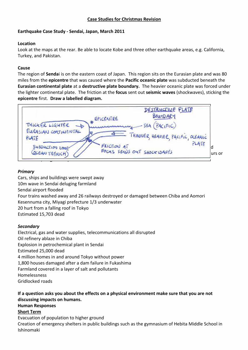
Case Studies for Christmas Revision Earthquake Case Study - Sendai, Japan, March 2011 Location Look at the maps at the rear. Be able to locate Kobe and three other earthquake areas, e.g. California, Turkey, and Pakistan. Cause The region of Sendai is on the eastern coast of Japan. This region sits on the Eurasian plate and was 80 miles from the epicentre that was caused where the Pacific oceanic plate was subducted beneath the Eurasian continental plate at a destructive plate boundary. The heavier oceanic plate was forced under the lighter continental plate. The friction at the focus sent out seismic waves (shockwaves), sticking the epicentre first. Draw a labelled diagram. Effects Try to think of effects as primary effects (caused directly by the ground shaking, immediate) and secondary effects (consequences of the primary effects that happen afterwards, sometimes hours or weeks later, longer term). Primary Cars, ships and buildings were swept away 10m wave in Sendai deluging farmland Sendai airport flooded Four trains washed away and 26 railways destroyed or damaged between Chiba and Aomori Kesennuma city, Miyagi prefecture 1/3 underwater 20 hurt from a falling roof in Tokyo Estimated 15,703 dead Secondary Electrical, gas and water supplies, telecommunications all disrupted Oil refinery ablaze in Chiba Explosion in petrochemical plant in Sendai Estimated 25,000 dead 4 million homes in and around Tokyo without power 1,800 houses damaged after a dam failure in Fukashima Farmland covered in a layer of salt and pollutants Homelessness Gridlocked roads If a question asks you about the effects on a physical environment make sure that you are not discussing impacts on humans. Human Responses Short Term Evacuation of population to higher ground Creation of emergency shelters in public buildings such as the gymnasium of Hebita Middle School in Ishinomaki
They wanted to have 600 temporary shelters to be built within two weeks, an additional 4,200 shelters to be constructed in four weeks, and 30,000 shelters in two months Emergency teams search and rescue Clear roads and repair bridges 20-30km "stay indoors" zone around the damaged Fukushima nuclear plant Long Term Finance Minister Yoshihiko Noda stated that most of the rebuilding will be completed in five years. The government plans to spend 19 trillion yen ($243 billion) over that period. Encourage tourism with offers on discounted airfares, free return tickets The central bank had offered 1tn yen ($13bn, £9bn) in special loans to banks Earthquake Preparedness Day in Japan Counter weights on tall buildings to reduce swaying Flexible steel structures in bridges and buildings to enable structures to move with the quake Shock absorbers/seismic isolators under buildings Monitoring and providing warning of quakes, possibly including an early warning system that stops underground trains and fires station and ambulance station doors from closing Deeper foundations Remember that most of these responses are only used in MEDCs
Coastal Flood Case Study Location: New Orleans, USA Be ready to locate this are on a world blank map as well as three other areas of the world where major coastal flooding occurs, e.g. Thames Estuary (1953), Queensland, Australia, Bangladesh. When: 29th – 31st August 2005 Extent: 80% of New Orleans flooded Causes Physical Hurricane Katrina (low pressure system) moved from the Gulf of Mexico into Lake Pontchartrain. This caused a storm surge (predicted at 8.5 metres high) from the North of the city. Sea becomes shallower towards land. Floodplain of the Mississippi river. Human New Orleans is built on the floodplain of the Mississippi river, 49% is located below sea level. North of the city built on reclaimed land which was originally marsh and swampland, this has dropped by 2.4 metres in some places. Levees with were designed to cope with this level of flooding failed, prevent natural flooding and raise water level in rivers, so if flooding does occur it is more severe, prevent delta forming, so there is less protection from storms. Global warming has led to sea levels rising as ice caps melt, warmer sea increases number and strength of hurricanes. Effects on Land and People Responses Short term 40,000 US army troops deployed to aid in relief distribution and control looting FEMA provided housing assistance to 700,000 FEMA paid hotel costs of 12,000 people and families Long Term $62.3 billion worth of aid granted for victims Proposal to restore 4,400 sq kilometres to former wetland to provide a barrier General Possible Responses to the Flood (consider small and large scale responses) Small (e.g. householders) Permeable driveways and paths Flood proof barriers in doorways Grass roofs to intercept rain Store valuables upstairs Sandbags and sealants to plug windows and doors Move carpets upstairs Replace carpets with tiles Weigh down plugs in sink
Short Term
(Immediate or Primary)
90% of Southeast Louisiana evacuated.
1 million evacuated from New Orleans.
25,000 initially evacuated to the Superdome, then to the Houston
Astrodome.
2000 people immunised against disease
Transport system flooded
Homes flooded
80% New Orleans Flooded
53 breach points in the Levees
Flooding reached 4.6 metres in places
Long Term
(Secondary Effects)
Some areas of the city flooded for weeks
1,836 people died
Total cost of Hurricane Katrina $108
billion
Housing Shortage
Displacement of 1 million people from the
region.
900,000 in Louisiana lost power
Oil refineries closed pushing up world oil
prices.
Lack of clean water
Large (e.g. government) Strategic flood plains allowed to flood Raise and strengthen embankments Dredge and widen rivers Stricter planning regulations over flood plain use Reforestation programs Better monitoring of weather and warnings given You may wish to contrast this flood, which affected an MEDC, with the next case study flood, which affected an LEDC. Why do the impacts of hazards such as floods vary between LEDCs and MEDCs? Think about what money can buy you before, during and after the hazardous event. Before Better monitoring of weather, sea and river levels Better forecasting Better and more rapid warning systems with TV, radio, internet, etc. Emergency services can be prepared and mobilized Evacuation often quicker as people are warned and transport is better Better defenses can be constructed During Emergency services arrive promptly Flood defenses are stronger Coordination of evacuation and defense is better After More services to help with aid and cleanup operation Quicker to rebuild as people have insurance policies Government offers assistance and compensation Bigger, stronger economies are less affected by floods
River Flooding Case Study Location: Indus, Pakistan. Be ready to locate this area on a world blank map as well as three other areas of the world where major flooding occurs, e.g. Ouse, Mississippi, Nile, and Yangtze. When: End July to mid-September 2010, Particularly 26-30 July
Extent: Approx. 1/5 of Pakistan underwater, 160,000 sq. km Causes Physical: Heavy Monsoon rains initially between 27th and 30th July. Above average rainfall in July and August, possibly associated with La Nina Second highest monsoon rainfall in last 50 years City of Peshawar had 274 mm in 24hrs breaking the previous record of 187 mm Human: Illegal logging Effects on Land and People Short Term (Immediate or Primary Effects) 20 million people affected, 10% of country’s population. 2000 dead, 3000 injured 1.9 million Homes destroyed. Damage to infrastructure: hospitals, bridges, power lines Crops destroyed 200,000 livestock killed. Responses United Nations Aid appeal for US$460 Million for the provision of food, shelter and clean water Federal Flood Commission (FFC) to execute flood control projects Possible Responses (keep in mind the financial wealth of LEDC nations) Raise the embankments (levées) surrounding major settlements Flood shelters on raised stilts for people to evacuate to Improved monitoring and forecasting of flood threats Warning people with megaphones and radio messages
Long Term
(Secondary Effects)
10 million people without access to clean, safe
water.
Risk of water-borne diseases.
4 million people suffered food shortages.
Fertile land destroyed and continued flooding –
difficult to plant next year’s crop
Mud-encrusted, unfertile fields. Livelihoods
destroyed.
Many people without homes, living in tents or
straw huts.
Deaths from lack of shelter and blankets in cold
winter.
Lack of transport and communications.
1 in 5 flood-affected children malnourished.
Short Term
(Immediate or Primary Effects)
20 million people affected, 10% of country’s
population.
2000 dead, 3000 injured
1.9 million Homes destroyed.
Damage to infrastructure: hospitals, bridges, power
lines
Crops destroyed
200,000 livestock killed.
Economic Activities Case Study Wal-Mart, Dhaka Bangladesh Location – Dhaka, Bangladesh Harvest Rich Factory outside Dhaka Bangladesh makes clothing and household goods for Wal-Mart. Wal-Mart is a transnational company.
4,263 stores and 660,000 workers in 15 countries outside the United States. There are wholly owned operations in Argentina, Brazil, Canada, and the UK.
2.1 million Employees worldwide, the company is the largest private employer in the US and Mexico, and one of the largest in Canada.
In the financial year 2010, Walmart's international division sales were $100 billion
Why locate here?
Improved technology means production can take place away from headquarters in MEDCs
Wal-Mart can pay lower wages
LEDC workforce is more flexible
Use of pre-existing factories so start-up costs remain low
Modern transport methods mean goods can be transported globally with ease
Trade restrictions can be avoided by using ports and airports in LEDCs Markets
Goods are sold almost exclusively in Wal-Mart shops in North America and Europe, sales are highest in USA and Canada
Effect of Wal-Mart in LEDCs Benefits
Creates jobs both directly and indirectly in host country
Attracts other companies and therefore factories
Increases host countries wealth
Provides expertise and opportunities for training
Increases exports (increases GDP)
Improves the skills of the local workforce
Improves local infrastructure
Often provides healthcare benefits for workers (meals, health checks) Negatives
Can cause environmental problems
Influences decisions made by local government
Low paid workers
Encourages poor working conditions and development of sweatshops
Host country less likely to develop its own industries
Workers often sacked without warning
Profits returned to shareholders, very little money remains in host country
TNC’s likely to pull out of country when economic conditions become unfavourable
Effects on MEDC’s Benefits
Greater profits
Consumers access to cheaper products and larger choices
Influence spread around world Negatives
Loss of manufacturing opportunities in UK and other MEDCs
No escaping products, pressure to by larger brand names
Larger companies continue to grow while small localised businesses do not
Factory System Inputs are things that are needed to make the system work, the processes are the actions that take place and the outputs are what are achieved at the end. Linkages are what can be reused by the factory from the outputs
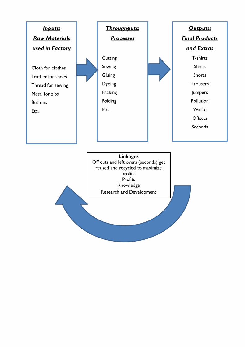
Inputs:
Raw Materials
used in Factory
Cloth for clothes
Leather for shoes
Thread for sewing
Metal for zips
Buttons
Etc.
Throughputs:
Processes
Cutting
Sewing
Gluing
Dyeing
Packing
Folding
Etc.
Outputs:
Final Products
and Extras
T-shirts
Shoes
Shorts
Trousers
Jumpers
Pollution
Waste
Offcuts
Seconds
Linkages
Off cuts and left overs (seconds) get
reused and recycled to maximize
profits.
Profits
Knowledge
Research and Development
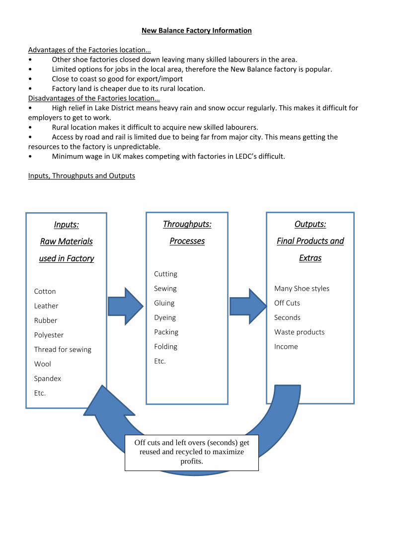
New Balance Factory Information Advantages of the Factories location… • Other shoe factories closed down leaving many skilled labourers in the area. • Limited options for jobs in the local area, therefore the New Balance factory is popular. • Close to coast so good for export/import • Factory land is cheaper due to its rural location. Disadvantages of the Factories location… • High relief in Lake District means heavy rain and snow occur regularly. This makes it difficult for employers to get to work. • Rural location makes it difficult to acquire new skilled labourers. • Access by road and rail is limited due to being far from major city. This means getting the resources to the factory is unpredictable. • Minimum wage in UK makes competing with factories in LEDC’s difficult. Inputs, Throughputs and Outputs
Inputs:
Raw Materials
used in Factory
Cotton
Leather
Rubber
Polyester
Thread for sewing
Wool
Spandex
Etc.
Throughputs:
Processes
Cutting
Sewing
Gluing
Dyeing
Packing
Folding
Etc.
Outputs:
Final Products and
Extras
Many Shoe styles
Off Cuts
Seconds
Waste products
Income
Off cuts and left overs (seconds) get
reused and recycled to maximize
profits.
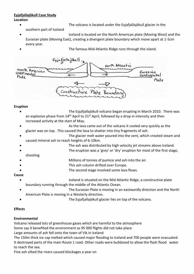
Eyjafjallajökull Case Study Location
The volcano is located under the Eyjafjallajökull glacier in the southern part of Iceland
Iceland is located on the North American plate (Moving West) and the Eurasian plate (Moving East), creating a divergent plate boundary which move apart at 1-5cm every year.
The famous Mid-Atlantic Ridge runs through the island.
Eruption
The Eyjafjallajökull volcano began erupting in March 2010. There was an explosive phase from 14th April to 21st April, followed by a drop in intensity and then increased activity at the start of May.
As the lava came out of the volcano it cooled very quickly as the glacier was on top. This caused the lava to shatter into tiny fragments of ash.
The glacier melt water poured into the vent, which created steam and caused mineral ash to reach heights of 6-10km.
The ash was distributed by high velocity jet streams above Iceland.
The eruption was a ‘grey’ or ‘dry’ eruption for most of the first stage, shooting
Millions of tonnes of pumice and ash into the air.
This ash column drifted over Europe.
The second stage involved some lava flows. Cause
Iceland is situated on the Mid Atlantic Ridge, a constructive plate boundary running through the middle of the Atlantic Ocean.
The Eurasian Plate is moving in an eastwardly direction and the North American Plate is moving in a Westerly direction.
The Eyjafjallajökull glacier lies on top of the volcano. Effects Environmental Volcano released lots of greenhouse gases which are harmful to the atmosphere Some say it benefited the environment as 95 000 flights did not take place Large amounts of ash fell onto the town of Vik in Iceland The 150m thick ice cap melted which caused major flooding to Iceland and 700 people were evacuated. It destroyed parts of the main Route 1 road. Other roads were bulldozed to allow the flash flood water to reach the sea. Fine ash silted the rivers caused blockages a year on
Economic Euro controlled traffic control closed all airports because of the risk of ash harming aeroplane engines. This was based on theory and not fact. After being closed for 6 days British airspace reopened. 95 000 flights were cancelled and it took several weeks to clear the backlog of flights Global airlines lost about £1.1bn Less fuel was needed and so 1.87million barrels were not in demand causing a loss of money in the oil industry It was estimated that London lost £102 million of tourist income which caused a knock on effect for workers travelling and businesses. Tens of thousands of people were left stranded, unable to get to work. Car Maker Nissan had to suspend production for 1 day. Producers of perishable goods were hit hard, see Kenya below: Global Impacts: Kenya
20% of the Kenyan economy is based on the export of green vegetables (beans, sugar-snap peas and okra) and cut flowers to Europe.
These are perishable goods and they are transported by plane to keep them fresh.
No flights into Europe meant products returned unsold and destroyed. Over 1 million flower stalks were unsold in the first two days.
Over 50,000 farmers were temporarily unemployed as their beans and peas could not be sold.
The ash cloud has cost the Kenyan economy millions of pounds during the flight ban. Social
1.2 million air passengers could not fly.
Many people missed weddings, funerals and long-awaited holidays.
Many people who lived under the flight path enjoyed a few noise free days
The World Health Organization said falling ash was ‘more bothersome than hazardous to your health’.
Doctors advised people with asthma, bronchitis or heart disease to remain indoors.
20 Icelandic farms near the volcano were destroyed by the flooding and the ash. The ash fall also poisoned animals.
Responses
The Icelandic government paid to dredge rivers or allow them to flood and create a new path.
Iceland had a good warning system with texts being sent to residents with a 30 minute warning.
The emergency services were well prepared.
The then UK Prime Minister Gordon Brown, ordered three navy ships to be sent to help stranded Brits unable to get home.
Ryanair laid on extra flights from Spain to the UK and has now had to comply with EU rules and pay for stranded passengers’ food and accommodation.
Thomas Cook sent rescue planes to Cancun, Heraklion and Sharm-el-Shake to return 2500 passengers.
Insurance companies refused to pay travellers for extra accommodation costs or the costs of alternative travel home as they said it was an ‘Act of God’. Most airlines did pay out reasonable cost to holidaymakers.