FLORENCE T.112N.-R.13W. - Schulz & Company...
8
FLORENCE T.112N.-R.13W. See Wacouta Page 46 I _i> r* Steve M Nelson -ilo etaI 160 187.5 34000 County Line 35000 36000
Transcript of FLORENCE T.112N.-R.13W. - Schulz & Company...

FLORENCE T.112N.-R.13W.
See Wacouta Page 46
I _i>r*
Steve MNelson -ilo eta I 160187.5
34000County Line
35000 36000

<P.O.(joocfaue, 1W 55027
Phone: 651-923-4769 • TOJQ 651-923-5096
EMNETT & WEGENER PROPERTY
LISTED PRICE
TERMS
APPROX. ACRES
APPROX. TILLABLE (Seller to provide FSA verification)
2019 REAL ESTATE TAXES
$ 704,000.00
CASH
192
42.85
$ 2,478
This information sheet is subject to errors and omissions. Schulz And Company Realty and Broker WillardB. Schulz do not assume the responsibility for the accuracy of the information contained in this document.
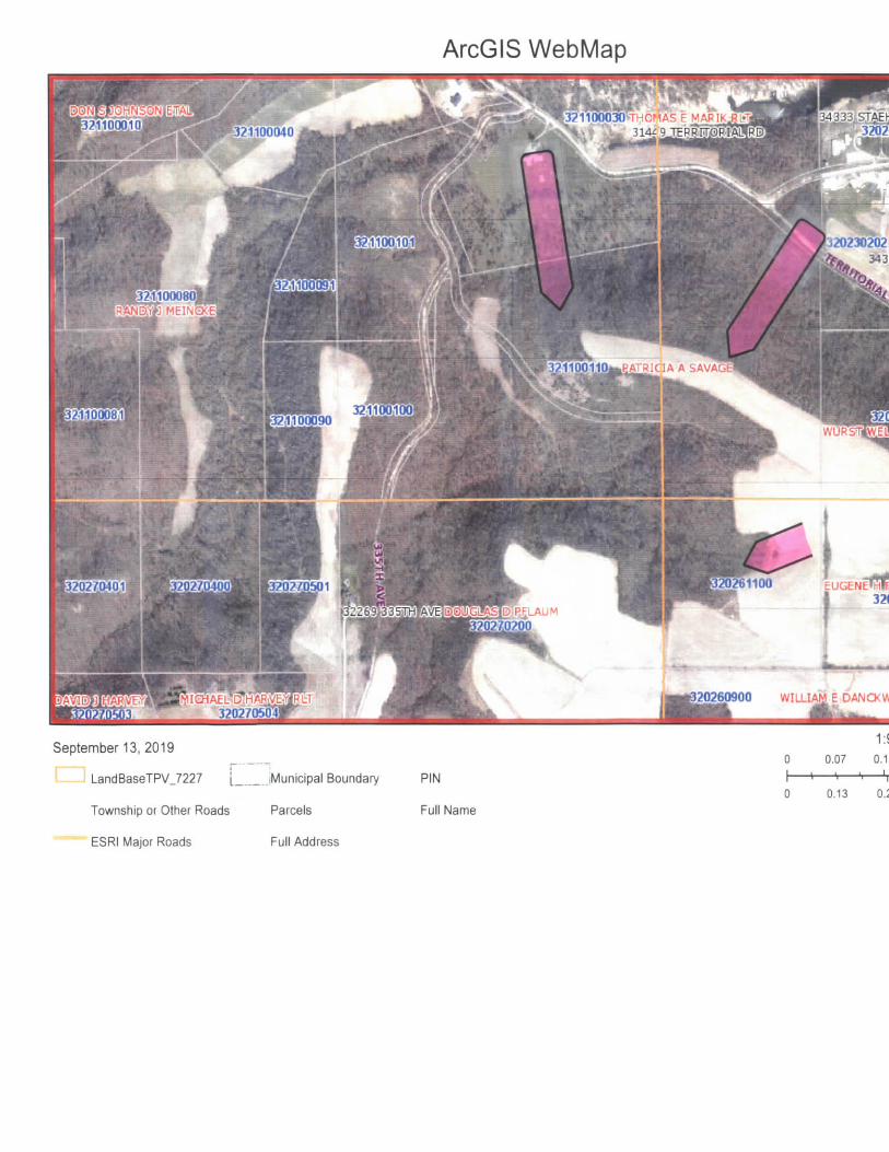
ArcGIS WebMap
J21100030vrHCMAS E MAPIKJilsli
12023020234352 STAEHLI
2-1,10008MEINGKE
110011Q^RATRIC1A A SAVAG
20260900 WILLIAM E DANCKWART
September 13, 2019
LandBaseTPV_7227 __jMunicipal Boundary
Township or Other Roads Parcels
ESRI Major Roads Full Address
1:9,600
0 0.07 0.15 0.3 mi
PIN
Full Name0 0.13 0.25 0.5km
ArcGIS WebApp Builder

Q_
fl3
TO"i-0)

Soils Map
©2Q19AanData. inc.
State: MinnesotaCounty: GoodhueLocation: 23-112N-13WTownship: FlorenceAcres: 16.18Date: 9/13/2019
If surety•••• I CUVTDMUVD OHLIPflfl IMFFIhG^F
Soils data provided by USDA and NRCS. -*. Agr Oaialic can
Area Symbol: MN049, Soil Area Version: 14
Code
N521C2
N521B
N521D2
SoilDescription
Mt. Carrollsilt loam, 6to 12percentslopes,moderatelyeroded
Mt. Carrollsilt loam. 2to 6percentslopes,moderatelyeroded
Mt. Carrollsilt loam,12 to 20percentslopes,
Acres
6.71
5.54
3.74
Percentof field
41.5%
34.2%
23.1%
PILegend
-
-
Non-IrrClass*c
Ille
lie
IVe
ProductivityIndex
80
90
67
Oats Alfalfahay
Bluegrasswhiteclover
Bromegrassalfalfa nay Corn Corn
silageOrchardgrassalsike
Orchardgrassred clover
Redcloverhay
Soybeans Timothyalsike
'n NCCPISoybeans
66
68
60

N508E
moderatelyeroded
Seaton siltloam,driftlessridge, 12 to20 percentslopes,moderatelyeroded
0.19 1 .2% IVe
Weighted Average
62
80.2
79
0.9
5
0.1
4
*_
6
0.1
131
1.5
20
0.2
5
0.1
5
0.1
4
*_
45
0.5
4
*_
71
*n 65.4
*n: The aggregation method is ^A/eighted Average using major components*c: Using Capabilities Class Dominant Condition Aggregation Method
Soils data provided by USDA and NRCS.

Aerial Map

Soils Map
Soils data provided by USDA and NRCS.92U1 9 AanDala Inc
State: MinnesotaCounty: GoodhueLocation: 26-112N-13WTownship: FlorenceAcres: 26.67Date: 9/13/2019
Maps PrwOBJ By
E& surety••••I cinrnwm CH.LIHI urmi V
6*gnDsM Ire 2019 , Ag-oaalncccm
Area Symbol; MN049, Soil Area Version: 14
Code
N521C2
N521D2
N521B
Soil Description
Ml. Carroll silt loam, 6 to 12 percent slopes,moderately eroded
Mt. Carroll silt loam, 12 to 20 percent slopes,moderately eroded
Mt. Carroll silt loam, 2 to 6 percent slopes, moderatelyeroded
Acres
13.15
6.77
6.75
Percent offield
49.3%
25.4%
25.3%
PILegend
™
Non-lrrClass *c
Ills
IVe
He
Weighted Average
ProductivityIndex
80
67
90
79.2
*n NCCPISoybeans
66
60
68
*n65
*n: The aggregation method is "Weighted Average using major components"*c: Using Capabilities Class Dominant Condition Aggregation Method