Flora and vegetation of banded iron formations of the ... · (Blatchford 1899) and CG Gibson in...
17
Conservation Science W. Aust. 8 (1) : 95–111 (2011) © The Government of Western Australia, 2011 Flora and vegetation of banded iron formations of the Yilgarn Craton: the Montague Range Zone of the Gum Creek Greenstone Belt WENDY A THOMPSON AND NIALL B SHEEHY Science Division, Department of Environment and Conservation, PO Box 51, Wanneroo, Western Australia, 6946. Email: [email protected] ABSTRACT The Montague Range of the Gum Creek Greenstone Belt is located in the central portion of the Yilgarn Craton, c. 70 km north of the township of Sandstone. Fifty permanent vegetation quadrats were established, within which all vascular flora and a series of environmental attributes were recorded. A total of 91 taxa were recorded, representing 28 families and 43 genera. Five taxa of conservation significance were identified, including Acacia burrowsiana (P1), Stenanthemum mediale (P1), Calytrix praecipua (P3), Sauropus ramosissimus (P3), and Baeckea sp. Melita Station (H Pringle 2738; P3). A single putative variant of the Acacia aneura complex was identified; further material of A. aneura aff. argentea is required for confirmation. Three taxa (A. aneura aff. argentea, A. aneura var. conifera, A. cockertoniana) represented significant range extensions. No weeds or regional endemics were collected during the survey. Six floristic communities were identified from the survey, which were related to topographical position, geology and edaphic factors. The Montague Range represents an important repository of significant taxa and floristic communities associated with banded ironstone formations. Any future exploration or development should ensure that the important conservation values and condition of the range are retained. Keywords: banded ironstone, floristic communities, mulga, Murchison, Yilgarn. INTRODUCTION The Montague Range is a distinct landform within the Gum Creek Greenstone belt in the Yilgarn Craton. The Gum Creek Greenstone belt is separated into two zones trending north-west, the Montague Range Zone and the Lake Mason Zone. The Montague Range Zone is located north and east of the Lake Mason Zone. Erosional processes have exposed the underlying Archaean regolith that forms the Montague Range. The result is a highly dissected landscape with widespread lateritic breakaways (Kimseed Environmental 1998). In addition to the exposed bedrock, the range contains alluvial drainage systems and scree slopes formed by the weathering of regolith, which contribute to the pediments and adjacent colluvial plains (Tingey 1985). STUDY SITE The Montague Range is situated in the centre of the Murchision bioregion (Interim Biogeographic Regionalisation of Australia—IBRA; Thackway & Cresswell 1995), approximately 70 km north of Sandstone and 100 km southwest of Wiluna, within the Wiluna and Sandstone Shires (Fig. 1). The greenstone belt trends north-west, covering c. 55 km from north to south, with a width c. 6–7 km. The latitudinal and longitudinal boundaries of the Range are roughly 27° 00” S, 27° 30” S and 119° 20” E and 119° 35” E, respectively. The land tenure for the Range includes Gidgee pastoral lease and the former Kaluwiri and Lake Mason pastoral leases, which are both now owned by the Department of Environment and Conservation (DEC) and managed for conservation. Land Use History The Murchison Region has a long history of pastoralism and mineral exploration, particularly gold mining. The Montague Range bears the evidence of both activities, including cattle grazing, gridlines, drill holes and mining pits. Access to the Range is facilitated by mineral exploration and gridline tracks. The potential for gold deposits in the Gum Creek Belt was identified by government geologists, including T Blatchford in 1898 (Blatchford 1899) and CG Gibson in 1908 (Gibson 1908). The Gidgee pastoral lease covers the majority of the central and north-west portion of the Range. Gidgee has a mixed history of stocking sheep, cattle and horses, as well as mining activities (Senior 1995).
-
Upload
doankhuong -
Category
Documents
-
view
216 -
download
1
Transcript of Flora and vegetation of banded iron formations of the ... · (Blatchford 1899) and CG Gibson in...

Conservation Science W. Aust. 8 (1) : 95–111 (2011)
© The Government of Western Australia, 2011
Flora and vegetation of banded iron formations of theYilgarn Craton: the Montague Range Zone of the GumCreek Greenstone Belt
WENDY A THOMPSON AND NIALL B SHEEHY
Science Division, Department of Environment and Conservation,
PO Box 51, Wanneroo, Western Australia, 6946.
Email: [email protected]
ABSTRACT
The Montague Range of the Gum Creek Greenstone Belt is located in the central portion of the Yilgarn Craton, c. 70
km north of the township of Sandstone. Fifty permanent vegetation quadrats were established, within which all
vascular flora and a series of environmental attributes were recorded. A total of 91 taxa were recorded, representing 28
families and 43 genera. Five taxa of conservation significance were identified, including Acacia burrowsiana (P1),
Stenanthemum mediale (P1), Calytrix praecipua (P3), Sauropus ramosissimus (P3), and Baeckea sp. Melita Station
(H Pringle 2738; P3). A single putative variant of the Acacia aneura complex was identified; further material of A.
aneura aff. argentea is required for confirmation. Three taxa (A. aneura aff. argentea, A. aneura var. conifera, A.
cockertoniana) represented significant range extensions. No weeds or regional endemics were collected during the
survey. Six floristic communities were identified from the survey, which were related to topographical position, geology
and edaphic factors. The Montague Range represents an important repository of significant taxa and floristic communities
associated with banded ironstone formations. Any future exploration or development should ensure that the important
conservation values and condition of the range are retained.
Keywords: banded ironstone, floristic communities, mulga, Murchison, Yilgarn.
INTRODUCTION
The Montague Range is a distinct landform within theGum Creek Greenstone belt in the Yilgarn Craton. TheGum Creek Greenstone belt is separated into two zonestrending north-west, the Montague Range Zone and theLake Mason Zone. The Montague Range Zone is locatednorth and east of the Lake Mason Zone. Erosionalprocesses have exposed the underlying Archaean regoliththat forms the Montague Range. The result is a highlydissected landscape with widespread lateritic breakaways(Kimseed Environmental 1998). In addition to theexposed bedrock, the range contains alluvial drainagesystems and scree slopes formed by the weathering ofregolith, which contribute to the pediments and adjacentcolluvial plains (Tingey 1985).
STUDY SITE
The Montague Range is situated in the centre of theMurchision bioregion (Interim BiogeographicRegionalisation of Australia—IBRA; Thackway &Cresswell 1995), approximately 70 km north of Sandstone
and 100 km southwest of Wiluna, within the Wiluna andSandstone Shires (Fig. 1). The greenstone belt trendsnorth-west, covering c. 55 km from north to south, witha width c. 6–7 km. The latitudinal and longitudinalboundaries of the Range are roughly 27° 00” S, 27° 30” Sand 119° 20” E and 119° 35” E, respectively. The landtenure for the Range includes Gidgee pastoral lease andthe former Kaluwiri and Lake Mason pastoral leases, whichare both now owned by the Department of Environmentand Conservation (DEC) and managed for conservation.
Land Use History
The Murchison Region has a long history of pastoralismand mineral exploration, particularly gold mining. TheMontague Range bears the evidence of both activities,including cattle grazing, gridlines, drill holes and miningpits. Access to the Range is facilitated by mineralexploration and gridline tracks. The potential for golddeposits in the Gum Creek Belt was identified bygovernment geologists, including T Blatchford in 1898(Blatchford 1899) and CG Gibson in 1908 (Gibson1908). The Gidgee pastoral lease covers the majority ofthe central and north-west portion of the Range. Gidgeehas a mixed history of stocking sheep, cattle and horses,as well as mining activities (Senior 1995).

96 WA Thompson & NB Sheehy
Figure 1. Map showing the location of the Montague Range survey area, with major landforms and landmarks indicated. Thelocations of the 50 permanent quadrats are marked by solid triangles (�).
Lake Mason is named for the surveyor and leaseholderHenry GB Mason, who passed through the region in 1900(Senior 1995). The Lake Mason station initially stockedcattle and later focused on sheep (Senior 1995) until theproperty was purchased by the Department ofConservation and Land Management (CALM, now DEC)in 2000. Rangeland condition of the former Lake Masonpastoral lease varies, with more than 50% considered in
poor to fair condition (Department of Conservation andLand Management 2001). At the time of purchase,evaluation of the lease suggested that condition on thelease was improving following low stocking rates andlimiting water availability (Department of Conservationand Land Management 2001).
The Gum Creek Greenstone Belt has the largestrecorded gold production for the region, at 39 t, which is
Flora and vegetation of Montague Range 97
primarily associated with mafic rocks (Wyche et al. 2004).There are active mining and exploration leases on theRange at present (Department of Mines and Petroleum2009). Open pit gold mining operated by ArmincoMining Pty Ltd occurred two kilometres west of Mt.Townsend, in the northern portion of the range, duringthe late 1990s. Legend Mining still operates a gold mineat Gidgee, which is currently under ‘care and maintenance’(Wyche et al. 2004).
Climate
The Montague Range sits in the central portion of theMurchison bioregion, which has an arid climate with hotsummers and cool winters. Rainfall is highly variable andoccurs sporadically throughout the year (Leighton 1998;Bureau of Meteorology 2009). There is a slight increasein mean rainfall during summer, generally associated withcyclonic activity.
The closest weather station to Montague Range isYeelirie, located c. 55 km east of the Range. Average annualrainfall at Yeelirie is 238 mm, based on records from 1928to 2009. March and September have the highest (31.5mm) and lowest (4.2 mm) mean monthly rainfall,respectively. The highest annual rainfall was recorded in1975 (506.8 mm) and the lowest rainfall recorded in 1950(42.8 mm). The single highest rainfall event occurred on30 March 1931, with 99.1 mm of rain recorded.
Temperatures have been recorded at Yeelirie from 1973to 2009. The average annual maximum is 28.7 °C andaverage annual minimum is 12.7 °C. The highesttemperatures occur between November and March, withmean maximum temperatures exceeding 30 °C. Januaryis the hottest month, with the record for mean maximumand mean minimum temperatures at 37.9 °C and 31.6°C, respectively. The highest daily maximum on record is46 °C recorded on 11 February 1991. The lowest dailyminimum temperatures occur between May andSeptember, where mean minimum temperatures are below10° C. The coldest month of the year is July, with theaverage maximum and minimum daily temperature of28.6 °C and 3.5° C, respectively. The coldest minimumtemperature of –5.1 ° C was recorded on 27 July 2000.
Geology
The Montague Range has been mapped and described onthe Sandstone 1:250,000 geological sheet (SG/50-16;Tingey 1985) and straddles the Montagu (Wyche & Doyle2006) and Youno Downs (Chen et al. 2006) 1:100,000map sheets. The Montague Range Zone of the Gum CreekBelt lies entirely in the northern portion of the YouanmiTerrane within the Southern Cross Domain in the YilgarnCraton (Cassidy et al. 2006). The Yilgarn Craton iscomposed of crustal rocks primarily formed during theLate Archaean (3.0–2.6 Ga; Myers 1993; Myers &Swagers 1997). The Yilgarn Craton occurs as a series ofgreenstone belts that have undergone low grademetamorphism (Myers & Swagers 1997) and are primarilysurrounded by granitoid (Anand & Paine 2002).
The Range is part of the larger Gum Creek GreenstoneBelt, occupying the north-east portion of the belt.Elevations are between c. 550 and 600 m above sea level(see Tingey 1985). The Montague Range features thehighest point on the Sandstone map sheet (SG/50-16),Mt. Townsend (660 m), and another noted peak, Mt.Marion (646 m; Tingey 1985). The Cenozoic depositsof the lower slopes, flats and outwash, are situated at c.550 m or below.
The Montague Range trends north-north-west, thetypical orientation of the greenstone belts of the SouthernCross Domain (Griffin 1990). The predominant geologyof the Range includes metabasalts, interspaced withirregular sequences of banded iron formations (BIF),metamorphosed ultramafic rocks and minor occurrencesof metasediments (Tingey 1985). The northern portionof the greenstone belt is largely overlain by deeplyweathered profiles of ferruginised duricrust (Tingey 1985).The central and southern section of the Range is principallycomposed of metabasalt with metamorphosed maficcomplexes and minor occurrences of quartzite and slate(Tingey 1985). The ferruginous material from Mt.Townsend and Mt. Marion has an iron ore content of30.1% and 33.6%, respectively (Connolly 1959).
Adjacent to the eastern periphery of the Range aresignificant areas of granite, including deeply weatheredprofiles and sandplains composed of residual and aeoliansands (Wyche & Doyle 2006). The lower slopes,particularly along the western boundary, are composed offerruginous gravel and grit with colluvial material derivedfrom reworked ferruginous duricrust and gravel. The lowerslopes and the adjacent outwash, which incorporatesalluvial drainage lines linked to surrounding floodplains,are allied to Cenozoic depositional activities (Wyche &Doyle 2006).
Murchison Region soils are typically red-brown hardpans overlain by shallow earthy loams, with the hillsprimarily shallow stony loams (Beard 1990). The soils ofthe greenstone belts of the Sandstone region are derivedfrom weathering and erosional processes, and arecharacteristically skeletal to shallow, poorly developed andacidic in nature (Churchward 1977; Hennig 1998). Soiltexture of the greenstone belts is typically loam to clayloam overlain by sandy loam and loams. Dominant soiltypes of the Montague Range are stony soils on the hills(Beard 1976; Churchward 1977), with shallow calcareousloams interspersed with shallow red earths and shallowcalcareous red clayey sands associated with breakaways(Hennig 1998). The Jundee land system, prevalent beyondthe western flanks of the range, is predominantlycomposed of shallow hardpans with minor occurrencesof deeper red earths (Hennig 1998).
Vegetation
Montague Range is situated within the Wiluna sub-Regionof the Austin Botanical District in the Eremaean Province(Beard 1976). The vegetation of the Murchison Regionis dominated by Acacia aneura (mulga; Beard 1990). Beard(1976) classified the Montague Range as low mulga

98 WA Thompson & NB Sheehy
woodland with adjacent areas of mulga and minoroccurrences of marble gum (Eucalyptus gonglyocarpa)and shrub steppe sandplains. Structurally, the communityis dominated by tall Acacia shrubs (>3 m), over sparsecover of low shrubs (1–2 m) with ephemeral herbs presentunder favourable conditions (Beard 1990). Other thanA. aneura, all other species are predominantly non-dominant when defining community composition (Beard1990).
The mulga communities on the rocky slopes aregenerally composed of tall shrubs of A. aneura, A.quadrimarginea, A. grasbyi and Hakea lorea over a mid-stratum of Senna sp. (formerly Cassia), Eremophila clarkei,E. latrobei and Ptilotus obovatus with an annualunderstorey (Beard 1976). Beard (1976) did notdifferentiate between the vegetation communities growingon granites and greenstones. The surrounding sandplainspredominantly contain scattered trees, typically Eucalyptuskingsmillii, E. lucasii and E. ebbanoensis, and shrubs overhummock grasslands of Triodia basedowii, T. pungens,and T. melvillei (Beard 1976).
The Montague Range is predominantly the Bevon landsystem, with gently undulating low rises, irregular hillsand stony plains with breakaways and occasional ridgesof BIF (Pringle & van Vreeswyk 1994; Payne et al. 1998).There are also elements of the Brooking (ridges of BIF),Felix (gently undulating stony plains and low rises)Gabinantha (ridges and hills of greenstone), Sherwood(granite overlain by stony plains and breakaways) andViolet (gently inclined stony or gravelly plains) landsystems on the Range, with the Jundee (outwashcomposed of ironstone gravels over hardpans) land systemabutting the western flanks and the Yanganoo (gentlyinclined hardpans) and Bullimore (sandplains) landsystems dominating the eastern plains adjacent to theRange (Payne et al. 1998).
The Bevon land system supports eight vegetationcommunities, principally mulga shrublands, Acaciashrublands or Acacia and Eremophila shrublands on stonyplains, with occasional cover of stony plains of bluebushmixed shrubland (Pringle 1998a, 1998b). Common tallshrubs include A. burkittii, A. quadrimarginea, A.ramulosa and A. tetragonophylla (Pringle 1998a, 1998b).Other widespread taxa in these communities areEremophila sp. (e.g. E. forrestii and E. latrobei), Ptilotusobovatus, Senna sp., Solanum lasiophyllum (KimseedEnvironmental 1998), Sida sp. and Scaevola spinescens(Pringle 1998a, 1998b). Additional taxa, frequentlyoccurring in the bluebush shrublands, are low chenopodsshrubs such as Maireana georgei, M. glomerifolia, andM. triptera (Pringle 1998a, 1998b).
Previous regional mapping (i.e. Beard 1976; Payne etal. 1998) has provided an overview of vegetation structureand composition associated with the greenstone belts andgranites of the Yilgarn Craton. However, recent surveyson greenstone belts and associated BIF in the YilgarnCraton have found that distinct vegetation communitiesoccur within (see Markey & Dillon 2008a, 2008b;Meissner & Caruso 2008a, 2008b, 2008c) and amongthese landscapes (Gibson et al. 2007). This study aimed
to record the floristic diversity, describe vegetation patternsand examine environmental correlates associated with theMontague Range in the Gum Creek Greenstone belt.
METHODS
In early October 2008, fifty 20 x 20 m permanent quadratswere established across the Montague Range so that thetopographical, geological and geomorphological variationacross the length and breadth of the range was represented.Survey sampling took place within 551–651 m range ofelevation. Quadrats were located so that the vegetationcommunities associated with the greenstone belt,particularly the occurrence of BIF and associated geology,were captured. Survey methods followed those of previoussurveys on greenstone belts in the Yilgarn Craton (e.g.Markey & Dillon 2008a, 2008b; Meissner & Caruso2008a, 2008b, 2008c). Quadrats were located across abroad topological sequence from hill crests down slopeto the colluvial deposits below the range, in areas withminimal disturbance or modification. Thus, we avoidedplacing quadrats where heavy grazing, evidence of clearingor exploration-related disturbance was obvious.
The quadrats were marked by four steel fence droppersand their locations recorded with a Garmin Map76 GPS.Photographs were taken at a set distance of 5 m fromeach corner. Site physical characteristics (landform, slope,aspect, litter and bare ground cover, size of coarsefragments, cover of surface rock fragments and bedrock,soil colour and texture) were recorded as a series ofdescriptive attributes and semi-quantitative scales asdefined by McDonald et al. (1998). Landform descriptionwas based on topographical position (crest, upper slope,mid-slope, lower slope or flat) and landform element type(e.g. hillcrest, hillslope, breakaway; McDonald et al. 1998).Coarse fragments and rock outcrop data were recorded asrock type present and as percent (%) cover. The sevencover classes were: zero cover (0); <2% cover (1); 2–10% (2); 10–20% (3); 20–50% (4); 50–90% (5); >90%(6). Site disturbance was ranked between zero and three,with zero (0) representing no effective disturbance andthree (3) being extensively cleared. Runoff was recordedas one of six classes (0 = no runoff, 1 = very slow, 2 =slow, 3 = moderately rapid, 4 = rapid, 5 = very rapid;McDonald et al. 1998).
Vegetation structure was determined by assigningdominant taxa to the relevant stratum, noting emergenttaxa where present (McDonald et al. 1998). The cover ofall vascular plants within each quadrat was recorded usingthe cover classes (D >70%, M 30–70%, S 10–30%, V<10%, I isolated plants, or L isolated clumps). Plantmaterial was collected for verification and vouchering atthe Western Australian Herbarium (WA Herbarium).Additional specimens were collected from areas adjacentto the plots, which contributed to the overall species listfor the range. Where sufficient representative plant materialwas available, it was lodged at the WA Herbarium.Nomenclature generally follows Paczkowska and Chapman(2000).

Flora and vegetation of Montague Range 99
Soil was collected from 20 regularly spaced intervalsacross the quadrat, bulked and sieved. The <2 mm fractionwas analysed by an inductively coupled plasma – atomicemission spectrometer (ICP–AES) for B, Ca, Cd, Co, Cu,Fe, K, Mg, Mn, Mo, Na, Ni, P, S and Zn, using theMehlich No. 3 procedure (Mehlich 1984). Molybdenumwas excluded from the analyses as it was below the levelof detection. Soil pH was measured on 1:5 soil–waterextracts in 0.01 M CaCl
2 (method S3; Rayment &
Higginson 1992). Organic carbon content wasdetermined using a modified Walkley–Black method(method 6A1) and soil nitrogen (N) determined using amodified Kjeldahl digest (method S10; Rayment &Higginson 1992).
The classification and ordination analyses wereundertaken on a presence/absence data matrix of the 86perennial taxa recorded in more than one quadrat, whichis consistent with previous greenstone belt studies (Gibson2004a, 2004b). The dissimilarity between quadrats wasdetermined using the Bray–Curtis measure and theResemblance routine in PRIMER v6 (Clarke & Gorley2006). The Bray–Curtis measure is a widely-usedassessment of ecological distance, which reflectscompositional change (Legendre & Legendre 1998;Anderson & Robinson 2003), providing quantitativeoutput for similarity between samples (Faith et al. 1987).The species by site matrix was then classified using flexibleunweighted pair-group mean average (UPGMA, β =–0.1) in PATN v3.11 (Belbin 1989). The similarity profile(SIMPROF) routine in PRIMER v6 (Clarke & Gorley2006) was used to determine, a priori, similarities in thestructure of communities between quadrats. A two-waytable was created based on these classification routines.Non-metric Multi-Dimensional Scaling (MDS) was usedto highlight groups determined through the SIMPROFprocedure.
The degree of association of individual species witheach community group, as determined by SIMPROF, wasmeasured using indicator species analysis (Dufrêne &Legendre 1997). Indicator values examine informationon constancy and fidelity of each species. Statisticalsignificance of the indicator values were determined bythe Monte Carlo randomization procedure performed with1000 iterations using PC-ORD (McCune & Mefford1999). The similarity percentages (SIMPER) analysesprovided information on those species typically foundwithin each community. The SIMPER routine inPRIMER determines those taxa contributing the greatest
similarity within a community and dissimilarity amongstcommunities (Clarke & Warwick 2001). Those taxacontributing ≥10% to the similarity within eachcommunity type are reported.
Relationships between environmental variables wereexamined using the nonparametric Spearman rankcorrelation routine in Statistix 7.1 (Analytical Software,Tallahassee, Florida). The environmental variables wereanalysed using Kruskal–Wallis nonparametric analysis ofvariance and post-hoc significance testing of means α =0.05 (Sokal & Rolf 1995), using groups determined bythe SIMPROF routing. An environmental data matrix wascreated that included soil chemical properties and sitephysical characteristics. The BIO-ENV routine within theBEST analyses procedure in PRIMER v. 6 was used todetermine which environmental variables had the highestcorrelation with the site resemblance matrix (Clarke &Gorley 2006). For the BIO-ENV routine, theenvironmental variables were transformed [log(1+x)] andnormalised prior to analyses.
RESULTS
A total of 91 taxa from 28 families and 43 genera wererecorded across 50 quadrats on the Montague Range (Fig.1). A further 13 species were collected from areas adjacentto the quadrats. The dominant families represented onthe range were Mimosaceae (23 taxa), Myoporaceae (10taxa), Chenopodiaceae (9 taxa) and Caesalpiniaceae (6taxa). The genera with the greatest representation wereAcacia (23 species), Eremophila (10 species) and Senna(6 species). The majority of the taxa found on the rangewere perennial shrubs. There were two annuals, twogeophytes and no weed species recorded from thequadrats.
Species richness ranged between six and 21 taxa perquadrat, with an average richness per quadrat of 11.9 +3.4 SD. Nine taxa were amalgamated into four speciescomplexes during analyses. All annuals, singletons andspecimens unidentifiable beyond genus were removedfrom the original species matrix, which resulted in a matrixof 86 taxa x 50 sites.
Priority Taxa
Five priority-listed taxa were collected during the survey(Table 1). All of these taxa have been previously recorded
Table 1
Priority taxa recorded from the Montague Range. Bioregion abbreviations: Mur = Murchison, Gas = Gascoyne, Yal =
Yalgoo, GD = Gibson Desert, GVD = Great Victoria Desert, LSD = Little Sandy Desert.
Family Taxon Status for Montague Status Bioregion
Mimosaceae Acacia burrowsiana New record P1 Mur, Gas
Rhamnaceae Stenanthemum mediale New record P1 Mur
Myrtaceae Baeckea sp. Melita Station (H Pringle 2738) New record P3 Mur, Gas, Yal
Myrtaceae Calytrix praecipua New record P3 Mur, Gas, GVD, LSD
Euphorbiaceae Sauropus ramosissimus New record P3 Mur, Gas, GD, GVD

100 WA Thompson & NB Sheehy
in the Murchison IBRA region, but represent new recordsfor the Montague Range. There were nine newpopulations of Stenanthemum mediale (P1) identifiedduring the survey. Prior to the survey, there were onlynine records on the WA Herbarium database, Florabase(Western Australian Herbarium 1998–) for this species.Taxa of conservation significance recorded include a newpopulation of A. burrowsiana (P1) and three newpopulations of each of the following taxa: Baeckea sp.Melita Station (H Pringle 2738; P3), Calytrix praecipua(P3) and Sauropus ramosissimus (P3).
Possible New Variety in the Mulga Complex
A potential new variety within the Acacia aneura complex(mulga) was identified during this survey. This putativenew variety was first collected during a flora survey onthe BIF of Lee Steere Range in the Gascoyne IBRA Region(Thompson & Sheehy 2011b). Acacia aneura aff. argentea(translucent aging to opaque) was identified as a possiblenew variety due to resin differing from A. aneura var.argentea (B Maslin pers. comm.1 ). Typical A. aneura var.argentea occurs within the mulga alliance identified bywinged pods and opaque resin (B Maslin pers. comm.).A single specimen collected during the survey was sterileand pods were not located to aid in identification. Furthercollections are necessary to verify the putative new variety.
Range Extensions
Range extensions for three taxa were recorded during thesurvey. The putative new variety of A. aneura aff. argentea(translucent aging to opaque) was previously identifiedfrom the Lee Steere Range in the south-east portion ofthe Gascoyne IBRA Region. The Montague Rangepopulation is a range extension of c. 250 km south-westof its only other known locality. Acacia aneura var. coniferahas a scattered distribution in the Eremaean botanicalregion. The collection from Montague Range representsa range extension of c. 200 km to the south-west of theclosest population on the northern boundary of theMurchison IBRA Region. The A. cockertoniana collectedon the Montague Range is an extension of c. 200 kmnorth-east from the closest population. Acaciacockertoniana is known primarily from the southern andsouth-western portion of the Murchison IBRA Region.
Hybrids/Integrades
A single hybrid and two interspecific hybrids wererecorded during the survey. All hybrids were known fromcollections held at the WA Herbarium. The hybridcollected was Maireana georgei x Enchylaena tomentosa.The interspecific hybrids were Prostanthera althoferi subsp.althoferi x campbellii and Senna glaucifolia x artemisioidessubsp. x sturtii.
Floristic Communities
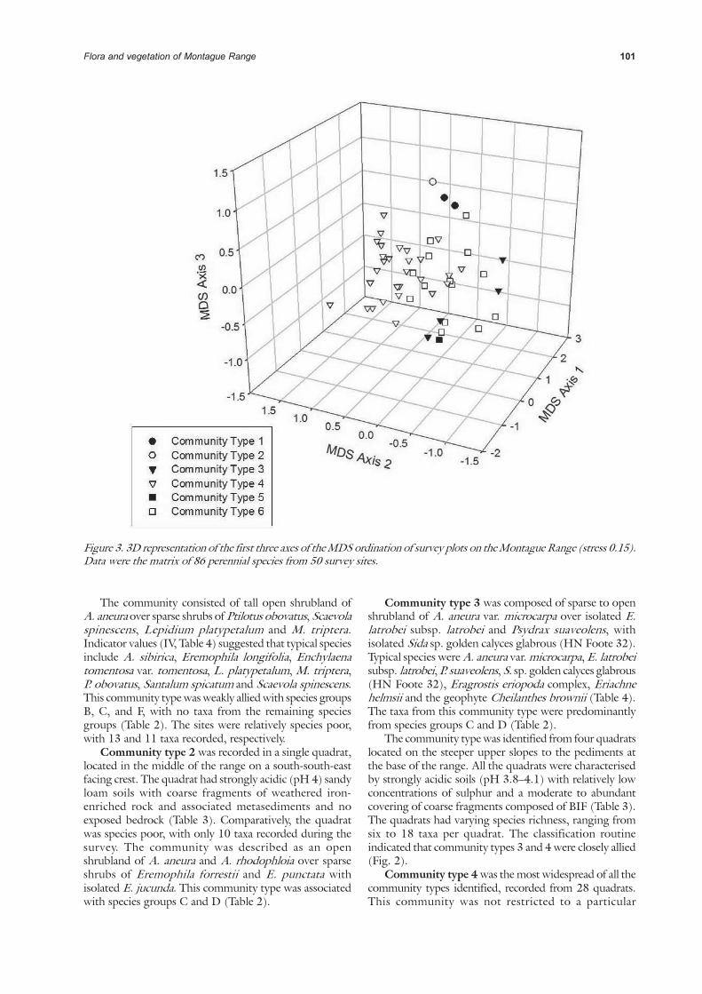
The classification routine based on hierarchical clusteringseparated the taxa into six species groups (A–F; Table 2).The most widespread species group, C, was composed oftaxa considered ubiquitous across the Range. Sixcommunity types were identified, based on the clusteringof samples and the SIMPROF routine (Fig. 2). Three ofthe vegetation communities recognized were recorded intwo or fewer quadrats. The relationship between speciesgroups and community types are discussed below. TheMDS routine showed the interrelationship between thesites, based on the resemblance matrix. Quadrats with asimilar suite of taxa clustered together, which correspondedto community type; represented on the 3D graph as theleast distance between points. The resulting stress valuewas 0.15 (Fig. 3).
Community type 1 was recorded in two quadrats,MNTG 14 and MNTG 23, both located in the upperportion of the landscape where soils had relatively highpH values (5.2 and 7.4, respectively; Table 3). High Caconcentrations from both quadrats suggested the presenceof calcareous soils. Sites were sandy loam soils overlain bya moderate cover of weathered iron-enriched coarsefragments.
Figure 2. Summary dendrogram, derived from theclassification analyses of the 86 taxa by 50 site matrix, for theMontague Range Zone of the Gum Creek Greenstone Belt.The six community types displayed were determined by theSIMPROF routine.
1 Bruce Maslin, Western Australian Herbarium, Department of Environment
and Conservation, Perth.
Flora and vegetation of Montague Range 101
Figure 3. 3D representation of the first three axes of the MDS ordination of survey plots on the Montague Range (stress 0.15).Data were the matrix of 86 perennial species from 50 survey sites.
The community consisted of tall open shrubland ofA. aneura over sparse shrubs of Ptilotus obovatus, Scaevolaspinescens, Lepidium platypetalum and M. triptera.Indicator values (IV, Table 4) suggested that typical speciesinclude A. sibirica, Eremophila longifolia, Enchylaenatomentosa var. tomentosa, L. platypetalum, M. triptera,P. obovatus, Santalum spicatum and Scaevola spinescens.This community type was weakly allied with species groupsB, C, and F, with no taxa from the remaining speciesgroups (Table 2). The sites were relatively species poor,with 13 and 11 taxa recorded, respectively.
Community type 2 was recorded in a single quadrat,located in the middle of the range on a south-south-eastfacing crest. The quadrat had strongly acidic (pH 4) sandyloam soils with coarse fragments of weathered iron-enriched rock and associated metasediments and noexposed bedrock (Table 3). Comparatively, the quadratwas species poor, with only 10 taxa recorded during thesurvey. The community was described as an openshrubland of A. aneura and A. rhodophloia over sparseshrubs of Eremophila forrestii and E. punctata withisolated E. jucunda. This community type was associatedwith species groups C and D (Table 2).
Community type 3 was composed of sparse to openshrubland of A. aneura var. microcarpa over isolated E.latrobei subsp. latrobei and Psydrax suaveolens, withisolated Sida sp. golden calyces glabrous (HN Foote 32).Typical species were A. aneura var. microcarpa, E. latrobeisubsp. latrobei, P. suaveolens, S. sp. golden calyces glabrous(HN Foote 32), Eragrostis eriopoda complex, Eriachnehelmsii and the geophyte Cheilanthes brownii (Table 4).The taxa from this community type were predominantlyfrom species groups C and D (Table 2).
The community type was identified from four quadratslocated on the steeper upper slopes to the pediments atthe base of the range. All the quadrats were characterisedby strongly acidic soils (pH 3.8–4.1) with relatively lowconcentrations of sulphur and a moderate to abundantcovering of coarse fragments composed of BIF (Table 3).The quadrats had varying species richness, ranging fromsix to 18 taxa per quadrat. The classification routineindicated that community types 3 and 4 were closely allied(Fig. 2).
Community type 4 was the most widespread of all thecommunity types identified, recorded from 28 quadrats.This community was not restricted to a particular

102 WA Thompson & NB Sheehy
Table 2
Two-way table of community types (columns) and species groups (rows) for the Montague Range. Taxa are sorted
within species groups. The squares represent the presence of the specific taxon in the corresponding quadrat.
topographical position or landform, as it occurred fromthe crests to the lower slopes of the range. Communitystructure was characteristically tall shrubs of A. aneura var.microcarpa and A. quadrimarginea, mid-stratum shrubsEremophila latrobei subsp. latrobei, E. jucunda and sparsePtilotus schwartzii. Indicator species of this communitywere A. aneura var. microcarpa, A. quadrimarginea,Dodonaea petiolaris, E. jucunda, E. longifolia, E. punctata,Aluta maisonneuvei subsp. auriculata, Prostanthera
campbellii, and Ptilotus schwartzii (Table 4).This community type was represented by species in
group C, composed of taxa generally not restricted bygradients in the landscape, with some association withspecies group D (Table 2). The similarity with speciesgroup D appeared to be associated with quadrats in thenorthern portion of the Range. There were six to 16 taxaper quadrat. The community occurs on strongly acidicsoils (pH 3.8–4.3; Table 3).

Flora and vegetation of Montague Range 103
Tab
le 3
Sum
mary
sta
tistics for
environm
enta
l variable
s, separa
ted b
y c
om
munity type, fo
r th
e M
onta
gue R
ange Z
one o
f th
e G
um
Cre
ek G
reensto
ne B
elt. M
ean v
alu
es w
ith s
tandard
devia
tion a
re l
iste
d f
or
com
munity t
ypes r
ecord
ed i
n m
ore
than o
ne q
uadra
t. D
iffe
rences w
ere
dete
rmin
ed u
sin
g K
ruskal–
Walli
s n
on-p
ara
metr
ic a
naly
sis
of
variance.
Only
com
munity types w
ith >
2 repre
senta
tive s
ites w
ere
inclu
ded in
the a
naly
ses. S
ignific
ance v
alu
es a
re in
dic
ate
d b
y *
(p <
0.0
5 =
*, p <
0.0
1 =
**,
p <
0.0
01 =
***
, p <
0.0
001 =
***
*);
post-
hoc d
iffe
rences w
ere
set
at α
= 0
.05.
Units o
f m
easure
ments
for
the p
ara
mete
rs a
re:
soil
chem
icals
= m
g/k
g;
abundance o
f fr
agm
ents
and o
utc
rop a
bundance =
cate
gorical m
axim
um
(0 =
0%
, 1 =
<2%
, 2 =
2–10%
, 3 =
>10–20 %
, 4 =
>20–50%
, 5 =
>50–90%
, 6 =
>90%
); topogra
phic
al positio
n: 1 =
cre
st, 2
= u
pper
slo
pe, 3 =
mid
-slo
pe,
4 =
low
er
slo
pe,
5 =
fla
t; s
pecie
s r
ichness =
num
ber
of
taxa p
er
quadra
t.

104 WA Thompson & NB Sheehy
Community type 5 was identified from one quadratand was closely allied with community type 6 and speciesgroups B and C (Figure 2; Table 2). The community wasfound on an east-north-east flat with a moderate cover ofcoarse fragments of weathered iron-enriched rock andstrongly acidic sandy clay loam soils (pH 4.3; Table 3).The quadrat was relatively species rich compared with themajority of other quadrats, with 17 taxa recorded. Thecommunity was described as an open tall shrubland of A.aneura with isolated mallees of Eucalyptus lucasii overisolated shrubland of Eremophila galeata, E. jucunda andS. ectogama.
Community type 6 was generally found on the mid-to lower-slopes, pediments and colluvial plains adjacentto the range; recorded in 14 quadrats. The communitywas described as sparse to open tall shrubland of A. aneuravar. microcarpa over open shrubland of E. latrobei subsp.latrobei and E. jucunda. Other species contributing tothis community included sparse cover of A. pruinocarpatrees and mid- to lower-stratum shrubs including P.obovatus, P. schwartzii and S. ectogama. Indicator valuesidentified the following species as typical of thecommunity: A. aneura var. microcarpa, A. pruinocarpa,E. conglomerata, E. galetea, E. jucunda, E. latrobei subsp.latrobei, M. convexa, P. obovatus, P. schwartzii, Sennaartemisioides subsp. helmsii, Sida ectogama andSpartothamnella teucriiflora (Table 4). This communityhad representatives from all species groups, however, theclosest relationships are with species groups B and C (Table2).
The community was characterised by shallow acidicsandy loam and sandy clay loam soils (pH 4.0–5.1). Thequadrats typically were covered by moderate to abundantcoarse fragments of weathered BIF, iron-enriched rock,quartz and associated metasediments, with the presenceof exposed bed rock associated with quadrats furtherupslope from the base of the range. The mean speciesrichness was 14.3 ± 3.3 SD, ranging from eight to 21taxa per quadrat (Table 3).
Environmental Variables
The soils of the Montague Range were typically stronglyacidic, with a mean pH of 4.17 ± 0.56 SD and a range of3.8 to 7.4 (Table 3). There were only three quadrats wheresoil pH was >5 and only a single quadrat with soil pH of7.4. The quadrats with higher pH values concomitantlyhad high soil Ca concentrations (>300 mg kg-1). The soilscollected on the Range were skeletal to shallow red-brownsandy loams and sandy clay loams. The high clay fractionin the soil matrix was typically associated with quadratson the footslopes, pediments and colluvial plains. Themajority of sites had >50% cover of coarse fragments,predominantly composed of weathered laminar ironstonesand iron enriched rock. Rock fragments were abundantat most survey sites, with an average cover category 4.6,which approaches 50–90% cover category (Table 3). Thequadrats typically had a high proportion of bare ground(mean 96% ± 2.7 SD) and very sparse cover of leaf litter(mean 10.1% ± 7.3 SD).
Table 4
Taxa with indicator values ≥ 25 for three of the six
community types of the Montague Range Zone.
Communities with ≤ 3 representative sites were excluded
from the analysis. Significant taxa are shown at p < 0.05
(from Monte Carlo permutation test), levels of significance
are indicated as: * = p < 0.05, ** = p < 0.01, *** = p <
0.001. Indicator values ≥ 25 are indicated by shading.
Community Types
Indicator Species 3 4 6
Psydrax suaveolens** 70 3 3
Sida sp. golden calyces glabrous 46 3 7
(HN Foote 32) *
Cheilanthes brownii* 44 1 0
Eragrostis eriopoda complex * 44 1 0
Acacia aneura var. microcarpa 34 31 34
Eremophila latrobei subsp. latrobei 34 29 34
Acacia sibirica 25 0 0
Eriachne helmsii 25 0 0
Acacia quadrimarginea * 4 47 9
Eremophila jucunda* 0 38 45
Ptilotus schwartzii 3 38 29
Eremophila punctata 24 28 0
Dodonaea petiolaris 0 26 4
Prostanthera campbellii 17 25 9
Aluta maisonneuvei subsp. auriculata 0 25 0
Acacia pruinocarpa** 6 0 51
Sida ectogama* 0 7 46
Eremophila galeata** 0 0 43
Senna artemisioides subsp. helmsii** 0 0 43
Ptilotus obovatus* 17 3 41
Acacia tetragonophylla* 7 1 37
Scaevola spinescens* 0 1 37
Acacia aneura var. argentea* 0 2 34
Maireana convexa* 0 0 29
Spartothamnella teucriiflora* 0 0 29
Eremophila conglomerata 0 17 28
Number of quadrats 4 28 14
There were strong intercorrelations between soilchemical properties (p < 0.01; Table 3). Soil pH and theelements Ca, Co, K, Mg, Mn, Na, Ni and Zn were allpositively intercorrelated (p < 0.01). All soil chemicalproperties were negatively correlated with sulphur (p <0.01), except Na and Ni (p > 0.05). Species richness waspositively related to Ca, K, Mg and Na content (p < 0.01).Iron content, soil nitrogen and organic carbon were highlyintercorrelated (p < 0.001), with the strongest relationship

Flora and vegetation of Montague Range 105
among all soil chemical properties between soil nitrogenand organic carbon (r
s
= 0.91, p < 0.0001).Abundance of coarse fragments and exposed bedrock,
soil depth, runoff and slope were all highly intercorrelated(p < 0.01), with the strongest relationship of all site physicalcharacteristics between runoff and slope (r
s = 0.82, p <
0.0001; Table 3). Other strong relationships existed betweentopographical position (e.g. 1 = crest to 5 = outwash)and abundance of exposed bedrock (r
s
= –0.61, p <0.0001). There were no significant correlations betweenspecies richness and site physical parameters (p > 0.01).
Community types recorded in two or fewer quadrats(types 1, 2 and 5) were excluded from the analysescomparing environmental variables between communities.There were significant differences (p < 0.05) betweencommunity types 4 and 6 for Ca, Co, Fe, Mg, Mn, Na,Ni, S, soil pH, and topographical position and rockoutcrop abundance (Table 3). There were significantdifferences between community type 4 and types 3 and 6for Zn (p < 0.001). Community type 4 had the lowestmean values for soil pH and the trace elements Ca, Co,Mg, Mn, Na and Ni, and the highest concentrations ofFe and S.
BIO-ENV
The PRIMER BIO-ENV routine examined whichenvironmental variables best correlated with the patternsin the site resemblance matrix. Mg, Ni, S, altitude andabundance of rock outcrop had the highest correlation
with the patterns within the site resemblance matrix (Rho= 0518). Magnesium was strongly correlated with Ni (r
s
= 0.77, p < 0.0001) and S (rs
= –0.49, p < 0.001).Altitude and abundance of exposed bedrock werepositively correlated (r
s = 0.38, p < 0.01). The high values
for altitude and abundance of exposed bedrock werealmost in complete opposition to the those of the soiltrace elements (Fig. 4). In particular, community type 2,with high values for all three trace elements, was clearlyseparated from the other sites (Fig. 4).
DISCUSSION
Flora and Vegetation Communities
There were 104 taxa recorded during the survey (91 ofwhich were from quadrats). This was markedly lower thanmany of the flora surveys in the greenstone belt flora ofthe Yilgarn Craton (e.g. Markey & Dillon 2008a, 2008b;Meissner & Caruso 2008a, 2008b, 2008c), and lower thanflora surveys carried out in association with the Mt.Townsend Project, which identified 131 taxa (KimseedEnvironmental 1998). However, prior to this survey therewere only 72 species lodged at the WA Herbarium fromthe vicinity of the Montague Range. Poor representationof annual taxa and lower absolute numbers of taxa collectedduring the survey was associated with the low annualrainfall preceding the survey.
Figure 4. Bubble plots of the four most highly correlated environmental parameters identified from the BIO-ENV routine(Rho = 0.518) overlaid on the MDS ordination. The plot for nickel was excluded as the trace element was highly positivelycorrelated with magnesium (p < 0.0001). Increase in the size of the bubble correlates with increasing value of the variable.The numbers inside the circles correspond to the community types.

106 WA Thompson & NB Sheehy
Previous flora surveys of the greenstone belts of theYilgarn Craton have identified taxa endemic to specificupland formations and taxa of conservation significance(Markey & Dillon 2008a, 2008b; Meissner & Caruso2008a, 2008b, 2008c). The flora survey of the MontagueRange Zone of the Gum Creek Greenstone belt identifiedno endemic taxa and five priority listed taxa, which waslower than the seven priority tax recorded from the LakeMason Zone of the Gum Creek Greenstone belt(Thompson & Sheehy 2011a). Stenanthemum mediale(P1) is regionally restricted and known from populationsat Jack Hills (c. 100 km west of Meekatharra) and YounoDowns and Yeelirie, which are both adjacent to MontagueRange. This taxon has been recorded as occurring onMontague Range (Kimseed Environmental 1998), butvouchered specimens were not lodged with the WAHerbarium. It is recommended that S. mediale isdownlisted from P1 to P2, as nine new populations wererecorded on the Montague Range and a single populationwas recorded in the Lake Mason Zone, south of Montague(Thompson & Sheehy 2011a). A further three taxacollected during the survey represent range extensions of200 km or greater, including the putative new variety ofAcacia aneura aff. argentea.
Six distinct vegetation communities were identifiedfollowing classification of the site resemblance matrix. Thisis similar to other greenstone belt studies (Markey & Dillon2008a, 2008b; Meissner & Caruso 2008a, 2008b, 2008c).The communities generally were not restricted to a specifictopographical position in the landscape, the exceptionbeing those communities identified from a single quadrat.The community types found on Montague Range had amore general distribution with regards to topography andlandscape element. The BIO-ENV routine showed thataltitude was highly correlated with the site resemblancematrix, however, there are inherently more complexrelationships influencing the vegetation patterns thansimple topographical position in the landscape.
Acacia aneura dominated all vegetation communities,generally as the tallest stratum. This is typical for theMurchison Region (Beard 1976; Beard 1990; Payne etal. 1998), and of flora surveys undertaken in the immediatevicinity (Kimseed Environmental 1998). Furthermore,taxa ubiquitous to other greenstone belts in the regionwere found across the Montague Range (e.g. Eremophilajucunda, E. latrobei subsp. latrobei). The primary sourceof similarity was the presence of some ubiquitous taxawithin community types. For example, A. aneura over E.latrobei subsp. latrobei with sparse Ptilotus schwartzii wereindicator taxa in both community type 4 on MontagueRange Zone and community type 2 at Lake Mason Zone(Thompson & Sheehy 2011a).
Environmental correlates
Most of the soils on the Montague Range were highlyacidic, as is typical of weathered regolith (Slattery et al.1999). Where soil pH approached neutral or alkalinevalues, there were concomitant higher calciumconcentrations, suggesting the presence of calcareous soils.
Soil textures were generally sandy loam, with sandy clayloams occurring only at mid- to lower slopes and onadjacent colluvial plains where deeper soil profiles routinelyform. The soil physical parameters of the Montague Rangeare typical of regolith associated with the Yilgarn Craton(Anand & Paine 2002). The variability in soil trace elementconcentrations were similar to those from other greenstoneand ironstone ranges in the Yilgarn Craton (Gibson 2004a,2004b; Gibson et al. 1997; Gibson & Lyons 1998a,1998b, 2001a, 2001b; Markey & Dillon 2008a, 2008b;Meissner & Caruso 2008a, 2008b, 2008c).
The Gum Creek Greenstone Belt is composed of bothmetabasalt and ultramafic rocks (Tingey 1985), which areknown to have high to very high concentrations of Mg(LeBas 2000; Gray & Murphy 2002). Sulphides andcarbonates are readily leached from the profile, mobilisingelements such as S, Na, Ca, Mg, Mn, Co, Cu, Ni and Zn(Butt et al. 2000; Britt et al. 2001; Anand 2005). Calcreteaccumulation has been linked with lowland communities(Anand et al. 1997); in this study, higher calciumconcentrations were recorded in communities on thefootslopes, pediments and colluvial plains.
Altitude, abundance of exposed bedrock andconcentrations of soil trace elements (Mg, Ni, and S) werecorrelated with 51.8% of the site resemblance matrix. Thissuggested that the position, underlying regolith andweathering of the profile has influenced the floristiccomposition. Weathering of the regolith mobiliseselements, leaching some and retaining others in varyingconcentrations (Britt et al. 2001; Anand 2005). Thoseelements with higher concentrations (e.g. Mg, K) are mostlikely not leached to the same extent as others, whereashigher Fe concentrations are likely attributed to theweathering of iron-enriched rock (Gray & Murphy 2002).
Community type 1 had soil physical characteristicstypical of mafic sites (e.g. higher Mg, Mn, Ni) as well as ahigher Ca level attributed to the presence of calcareoussoils. The other communities exhibited more moderateconcentrations of trace elements. The most noticeablesignificant environmental differences occurred betweencommunity type 4 (widespread locations with ubiquitoustaxa—A. aneura, E. latrobei and P. schwartzii) andcommunity type 6 (mid- to lower slopes with ubiquitoustaxa). Higher concentrations of chemical elements, exceptFe and S, were linked to community type 6.
Conservation Significance
The Montague Range has a long history of grazing,mineral exploration and mining. Evidence of the impactof these activities was apparent on the range, in particularthe presence of livestock, extensive gridline tracks, drillholes and open cut mining. The history of land disturbancecombined with the low rainfall preceding the survey werelikely contributing factors to the poor representation ofannuals and generally low species richness.
While the range had lower levels of species richnessthan other BIF ranges in the Yilgarn, the range is still animportant repository of taxa of conservation significanceand taxonomic uncertainty. This is similar to other areas

Flora and vegetation of Montague Range 107
on the BIF ranges of the Yilgarn (Gibson 2004 a, 2004b;Gibson & Lyons 1998a, 1998b, 2001a, 2001b; Gibsonet al. 1997; Markey & Dillon 2008a, 2008b; Meissner &Caruso 2008a, 2008b, 2008c). The south-east portion ofthe range occurs on land managed by the Department ofEnvironment and Conservation, but remains unclassifiedwithin the conservation estate. At present, there are noBIF ranges designated within Class A Nature Reserves.
ACKNOWLEDGEMENTS
We thank Colin and Marilyn Bernhardt of Youno Downsand Apex Minerals for facilitating access to the MontagueRange. We appreciate the assistance of the staff and visitingscientists at the Western Australian Herbarium, especiallyKarina Knight, Rob Davis, Steve Dillon, Mike Hislop,Peter Jobson, Bruce Maslin, Frank Obbens, Jordan Reid,Barbara Rye, and Malcolm Trudgen for their taxonomicexpertise. We thank Jessica Allen for producing the mapof the study area. Stephen van Leeuwen and Neil Gibsonprovided advice and support during the project. Thisproject was funded by the Department of Environmentand Conservation, Western Australia, through theBiodiversity Conservation Initiative.
REFERENCES
Anand RR (2005) Weathering history, landscape evolutionand implications for exploration. In RegolithLandscape Evolution Across Australia: A Compilationof Regolith Landscape Case Studies with RegolithLandscape Evolution Models (eds RR Anand, P deBroekert), pp. 2–40. Cooperative Research Centre forLandscape Environments and Mineral Exploration,Perth.
Anand RR, Phang C, Wildman JE, Lintern MJ (1997)Genesis of some calcrete in the southern YilgarnCraton, Western Australia: Implications for mineralexploration. Australian Journal of Earth Sciences 44,87–103.
Anand RR, Paine M (2002) Regolith geology of theYilgarn Craton, Western Australia: Implications forexploration. Australian Journal of Earth Sciences 49,3–162.
Anderson MJ, Robinson J (2003) Generaliseddiscrimination analysis based on distances. Australianand New Zealand Journal of Statistics 45, 301–318.
Beard JS (1976) Vegetation Survey of Western Australia.Murchison 1:1,000,000 Vegetation Series. ExplanatoryNotes to Sheet 6. Vegetation of the Murchison.University of Western Australia Press, Perth.
Beard JS (1990) Plant Life of Western Australia. KangarooPress, Perth.
Belbin L (1989) PATN Technical Reference. CSIRODivision of Wildlife and Ecology, ACT.
Blatchford T (1899) A Geological Reconnaissance of the
Country at the Heads of the Murchison and SandfordRivers, in the Murchison, East Murchison, and PeakHill Goldfields. Report of Torrington Blatchford, BA,Assistant Government Geologist.
Britt AF, Smith RE, Gray DJ (2001) Element mobilitiesand the Australian regolith—a mineral explorationperspective. Marine Freshwater Research 52, 25–39.
Bureau of Meteorology (2009) Climate Statistics forAustralian Locations. Available at http://www.bom.gov.au/climate/averages/. [Accessed May2009]
Butt CRM, Lintern MJ, Anand RR (2000) Evolution ofregoliths and landscapes in deeply weathered terrain—implications for geochemical exploration. Ore GeologyReviews 16, 167–183.
Cassidy KF, Champion DC, Krapez B, Barley ME, BrownJA, Blewett RS, Groenewald PB, Tyler IM (2006) ARevised Geological Framework for the Yilgarn Craton,Western Australia. Geological Survey of WesternAustralia, Record 2006/8, Perth.
Clarke KR, Warwick RM (2001) Change in MarineCommunities: An Approach to Statistical Analysis andInterpretation, 2nd ed. PRIMER-E, Plymouth.
Clarke KR, Gorley RN (2006) PRIMER v6:User Manual/Tutorial. PRIMER-E, Plymouth.
Chen SF, Wyche S, Doyle MG (2006) Youno Downs,Western Australia. Western Australian GeologicalSurvey 1:100,000 Geological Series Sheet 2743.Geological Survey of Western Australia, Perth.
Churchward HM (1977) Landforms, Regoliths and Soilsof the Sandstone – Mt Keith Area,Western Australia.Division of Land Resources Management CSIRO,Land Resources Management Series No. 2, Australia.
Connolly RR (1959) Montague Range. In Iron Ores inWestern Australia (ed RR Connolly), pp. 46–72.Mineral Resource Bulletin 7, Geological Survey ofWestern Australia, Perth.
Department of Conservation and Land Management(2001) ‘Black Range and Lake Mason Pastoral Leases2001–2006. Interim Management Guidelines’.Department of Conservation and Land Management,Perth.
Department of Mines and Petroleum (2009) Tengraph®Online. Available at: http://www.dmp.wa.gov.au/3980.aspx [Accessed May 2009].
Dufrêne M, Legendre P (1997) Species assemblages andindicator species: The need for a flexible asymmetricalapproach. Ecological Monographs 67, 345–366.
Faith D, Minchin P, Belbin L (1987) Compositionaldissimilarity as a robust measure of ecological distance.Vegetatio 69, 57–68.
Gibson CG (1908) Report upon the Auriferous Depositsof Barrambie and Errolls (Cue District) and GumCreek (Nannine District) in the Murchison Goldfield;also Wiluna (Lawlers District), in the East Murchison

108 WA Thompson & NB Sheehy
Goldfield. Geological Survey of Western Australia,Perth, Bulletin 34.
Gibson N (2004a) Flora and vegetation of the EasternGoldfields Ranges: Part 6. Mt Manning Range. Journalof the Royal Society of Western Australia 87, 35–47.
Gibson N (2004b) Flora and vegetation of the EasternGoldfields Ranges: Part 7. Middle and South Ironcap,Digger Rock and Hatter Hill. Journal of the RoyalSociety of Western Australia 87, 49–62.
Gibson N, Coates DJ, Thiele KR (2007) Taxonomicresearch and the conservation status of flora in theYilgarn Banded Iron Formation ranges. Nuytsia 17,1–12.
Gibson N, Lyons MN (1998a) Flora and vegetation ofthe Eastern Goldfields Ranges: Part 2. Bremer Range.Journal of the Royal Society of Western Australia 81,107–117.
Gibson N, Lyons MN (1998b) Flora and vegetation ofthe Eastern Goldfields Ranges: Part 3. Parker Range.Journal of the Royal Society of Western Australia 81,119–129.
Gibson N, Lyons MN (2001a) Flora and vegetation ofthe Eastern Goldfields ranges: Part 4: Highclere Hills.Journal of the Royal Society of Western Australia 84,71–81.
Gibson N, Lyons M (2001b) Flora and vegetation of theEastern Goldfields ranges: Part 5: Hunt Range,Yendilberin and Watt Hills. Journal of the RoyalSociety of Western Australia 84, 129–142.
Gibson N, Lyons MN, Lepschi BJ (1997) Flora andvegetation of the eastern goldfields ranges, Part 1:Helena and Aurora Range. CALMScience 2, 231–246.
Gray J, Murphy B (2002) Parent material and soildistribution. Natural Resource Management 5, 2–12.
Griffin TJ (1990) Southern Cross Province. In Geologyand Mineral Resources of Western Australia: WesternAustralia Geological Survey, Memoir 3 (eds AFTrendall, JS Myers, RM Hocking), pp. 60–77.Geological Survey of Western Australia, Perth.
Hennig P (1998) Soils. In An Inventory and ConditionSurvey of the Sandstone – Yalgoo – Paynes Find Area,Western Australia (eds AL Payne, AME van Vreeswyk,HJR Pringle, KA Leighton, P Hennig), pp. 95–118.Technical Bulletin No. 90, Agriculture WesternAustralia, South Perth.
Kimseed Environmental (1998) ‘Mt. Townsend Project.A Report on Flora, Vegetation, Vertebrate Fauna andSoils’. Unpublished report prepared for Gidgee GoldMine (Arminco Mining Pty Ltd). KimseedEnvironmental Pty Ltd, Perth.
Le Bas MJ (2000) Reclassification of the high-Mg andpicritic volcanic rocks. Journal of Petrology 41, 1467–1470.
Legendre P, Legendre L (1998) Numerical Ecology, 2nded. Elsevier Science, Amsterdam.
Leighton KA (1998) Climate. In An Inventory andCondition Survey of the Sandstone – Yalgoo – PaynesFind Area, Western Australia (eds. AL Payne, AMEVan Vreeswyk, HJR Pringle, KA Leighton, P Hennig),pp. 19–37. Agriculture Western Australia, TechnicalBulletin No. 90, South Perth.
Mabbutt JA, Litchfield WH, Speck NH, Sofoulis J, WilcoxDG, Arnold JA, Brookfield M, Wright RL (1963)General Report on the Lands of the Wiluna–Meekatharra Area, Western Australia, 1958. CSIRO,Land Research Series No. 7, Melbourne.
Markey AS, Dillon SJ (2008a) Flora and vegetation ofthe banded iron formations of the Yilgarn Craton: thecentral Tallering Land System. Conservation ScienceWestern Australia 7, 121–149.
Markey AS, Dillon SJ (2008b) Flora and vegetation ofthe banded iron formations of the Yilgarn Craton: theWeld Range. Conservation Science Western Australia7, 151–176.
Meissner R, Caruso Y (2008a) Flora and vegetation ofthe banded iron formations of the Yilgarn Craton:Koolanooka and Perenjori Hills. Conservation ScienceWestern Australia 7, 73–88.
Meissner R, Caruso Y (2008b) Flora and vegetation ofthe banded iron formations of the Yilgarn Craton: JackHills. Conservation Science Western Australia 7, 89–103.
Meissner R, Caruso Y (2008c) Flora and vegetation ofthe banded iron formations of the Yilgarn Craton:Mount Gibson and surrounding area. ConservationScience Western Australia 7, 105–120.
McCune B, Mefford MJ (1999) PC-ORD. MultivariateAnalysis of Ecological Data, Version 4. MjM SoftwareDesign, Glenden Beach, Oregon, USA.
McDonald RC, Isbell RF, Speight JG, Walker J, HopkinsMS (1998) Australian Soil and Land Survey: FieldHandbook, 2nd ed. Department of Primary Industriesand Energy and CSIRO, Australia.
Mehlich A (1984) Mehlich 3 soil test extractant: Amodification of Mehlich 2. Communications of SoilScience and Plant Analysis 15, 1409–1416.
Myers JS (1993) Precambrian history of the WestAustralian Craton and adjacent orogens. AnnualReview of Earth and Planetary Sciences 21, 453–485.
Myers JS, Swagers C (1997) The Yilgarn Craton. InGreenstone Belts (eds M de Wit and LD Ashwal), pp.640–656. Clarendon Press, Oxford.
Paczkowska G, Chapman AR (2000) The WesternAustralian Flora: A Descriptive Catalogue. WildflowerSociety of Western Australia, Western AustralianHerbarium, CALM and Botanic Garden Authority,Perth.
Payne AL, Van Vreeswyk AME, Pringle HJR (1998) LandSystems. In An Inventory and Condition Survey ofthe Sandstone – Yalgoo – Paynes Find Area, WesternAustralia (eds. AL Payne, AME Van Vreeswyk, HJR

Flora and vegetation of Montague Range 109
Pringle, KA Leighton, P Hennig), pp. 187–344.Technical Bulletin No. 90, Agriculture WesternAustralia, South Perth.
Pringle HJR, van Vreeswyk AME (1994) Land Systems.In An Inventory and Condition Survey of the North-Eastern Goldfields, Western Australia (eds. HJRPringle, AME Van Vreeswyk, SA Gilligan), pp. 171–292. Technical Bulletin No. 87, Department ofAgriculture, Western Australia, South Perth.
Pringle HJR (1998a) Ecological Assessment. In AnInventory and Condition Survey of the Sandstone –Yalgoo – Paynes Find Area, Western Australia (eds ALPayne, AME Van Vreeswyk, HJR Pringle, KALeighton, P Hennig), pp. 131–186. Technical BulletinNo. 90, Agriculture Western Australia, South Perth.
Pringle HJR (1998b) Vegetation. In An Inventory andCondition Survey of the Sandstone – Yalgoo – PaynesFind Area, Western Australia (eds AL Payne, AMEVan Vreeswyk, HJR Pringle, KA Leighton, P Hennig),pp. 119–129. Technical Bulletin No. 90, AgricultureWestern Australia, South Perth.
Rayment GE, Higginson FR (1992) AustralianLaboratory Handbook of Soil and Water ChemicalMethods. Inkata Press, Melbourne.
Slattery WJ, Conyers MK, Aitken RL (1999) Soil pH,aluminium, manganese and lime requirements. In SoilAnalysis: An Interpretation Manual (eds KI Peverill,LA Sparrow, DJ Reuter), pp. 103–128. CSIROPublishing, Collingwood, VIC.
Senior SL (1995) Sandstone from Gold to Wool and BackAgain. Shire of Sandstone, Sandstone, WesternAustralia.
Sokal RR, Rolf FJ (1995) Biometry. WH Freeman andCo., New York.
Thackway R, Cresswell ID (1995) An InterimBiogeographic Regionalisation for Australia: AFramework for Setting Priorities in the NationalReserves System Cooperative Program, Version 4.0.National Reserves System Cooperative Program,Australian Nature Conservation Agency, Canberra.
Thompson WA, Sheehy NB (2011a) Flora and vegetationof banded iron formations of the Yilgarn Craton: theLake Mason Zone of the Gum Creek Greenstone Belt.Conservation Science Western Australia 8, 77–94.
Thompson WA, Sheehy NB (2011b) Flora and vegetationof banded iron formations of the Yilgarn Craton: theLee Steere Range. Conservation Science WesternAustralia 8, 61–76.
Tingey RJ (1985) Sandstone, Western Australia,1:250,000 Geological Series—Explanatory Notes,Sheet SG/50-16. Geological Survey of WesternAustralia, Perth.
Western Australian Herbarium (1998–) Florabase—TheWestern Australian Flora. Department of Environmentand Conservation. Available at http://florabase.dec.wa.gov.au/ [Accessed May 2009].
Wyche S, Doyle MG (2006) Montagu, Western Australia.Western Australian Geological Survey 1:100 000Geological Series Sheet 2843. Geological Survey ofWestern Australia, Perth.
Wyche S, Chen SF, Doyle MG (2004) Recent Mappingin the Sandstone Region: Implications for GoldMineralization. Geological Survey of WesternAustralia, Record 2004/5, Perth.

110 WA Thompson & NB Sheehy
APPENDIX A
Flora list for the Montague Range Zone of the Gum Creek Greenstone Belt, including collections made outside of the
survey quadrat boundaries. Nomenclature follows Packowska and Chapman (2000).
Malvaceae
Sida ectogama
Sida sp. Excedentifolia (JL Egan 1925)
Sida sp. golden calyces glabrous (HN Foote 32)
Sida sp. verrucose glands (FH Mollemans 2423)
Mimosaceae
Acacia aff. coolgardiensis
Acacia aneura aff. argentea (transluscent aging
to opaque resin)
Acacia aneura var. alata (narrow phyllode
variant) BRM 9058
Acacia aneura var. argentea
Acacia aneura var. argentea (narrow phyllode
variant) BRM 9745
Acacia aneura var. conifera
Acacia aneura var. microcarpa
Acacia aneura var. microcarpa (broad,
incurved phyllode variant) BRM 9929
Acacia aneura var. tenuis (grey) BRM 9191C
Acacia burrowsiana P1
Acacia cockertoniana
Acacia craspedocarpa
Acacia effusifolia
Acacia masliniana
Acacia minyura
Acacia paraneura
Acacia pruinocarpa
Acacia quadrimarginea
Acacia ramulosa var. linophylla
Acacia rhodophloia
Acacia sibirica
Acacia tetragonophylla
Acacia xanthocarpa
Myoporaceae
Eremophila conglomerata
Eremophila exilifolia
Eremophila forrestii
Eremophila galeata
Eremophila jucunda
Eremophila latrobei subsp. latrobei
Eremophila longifolia
Eremophila oppositifolia subsp. angustifolia
Eremophila pantonii
Eremophila punctata
Myrtaceae
Aluta maisonneuvei subsp. auriculata
Baeckea sp. Melita Station (H Pringle 2738) P3
Calytrix desolata
Calytrix praecipua P3
Eucalyptus carnei
Eucalyptus kingsmillii subsp. kingsmillii
Eucalyptus lucasii
Micromyrtus sulphurea
Papilionaceae
Mirbelia rhagodioides
Poaceae
Eragrostis eriopoda/xerophila/setifolia complex
Eriachne helmsii
Eriachne mucronata
Eriachne pulchella subsp. pulchella
Paspalidium basicladum
Acanthaceae
Harnieria kempeana subsp. muelleri
Adiantaceae
Cheilanthes brownii
Cheilanthes sieberi subsp. sieberi
Amaranthaceae
Ptilotus obovatus
Ptilotus roei
Ptilotus schwartzii
Asclepiadaceae
Marsdenia australis
Sarcostemma viminale subsp. australe
Asteraceae
Olearia humilis
Brassicaceae
Lepidium platypetalum
Caesalpiniaceae
Senna artemisioides subsp. filifolia
Senna artemisioides subsp. helmsii
Senna artemisioides subsp. petiolaris
Senna artemisioides subsp. x artemisioides
Senna artemisioides subsp. x sturtii
Senna glaucifolia
Senna glaucifolia x artemisioides subsp. x sturtii
Senna sp. Meekatharra (E Bailey 1–26)
Chenopodiaceae
Enchylaena tomentosa var. tomentosa
Maireana convexa
Maireana georgei
Maireana georgei x Enchylaena tomentosa
Maireana thesioides
Maireana triptera
Rhagodia drummondii
Sclerolaena fusiformis
Convolvulaceae
Duperreya sericea
Cupressaceae
Callitris columellaris
Dilleniaceae
Hibbertia arcuata
Euphorbiaceae
Sauropus ramosissimus P3
Frankeniaceae
Frankenia pauciflora
Goodeniaceae
Goodenia macroplectra
Scaevola spinescens
Lamiaceae
Prostanthera althoferi subsp. althoferi
Prostanthera althoferi subsp. althoferi x campbellii
Prostanthera campbellii
Spartothamnella teucriiflora
Loranthaceae
Amyema preissii

Flora and vegetation of Montague Range 111
Proteaceae
Grevillea berryana
Hakea preissii
Rhamnaceae
Stenanthemum mediale P1
Rubiaceae
Psydrax latifolia
Psydrax rigidula
Psydrax suaveolens
Santalaceae
Exocarpos aphyllus
Santalum spicatum
Sapindaceae
Dodonaea adenophora
Dodonaea petiolaris
Dodonaea rigida
Solanaceae
Solanum ashbyii/lasiophyllum complex
Solanum orbiculatum subsp. orbiculatum
Sterculiaceae
Brachychiton gregorii
Stylidiaceae
Stylidium induratum