Floods and Dredging - CIWEM...Executive summary We conclude that dredging can play an important role...
25
Floods and Dredging – a reality check February 2014 supported by the Blueprint for Water
Transcript of Floods and Dredging - CIWEM...Executive summary We conclude that dredging can play an important role...

Flo
od
s a
nd D
red
gin
g–
a re
alit
y c
hec
k
February 2014
supported by
the Blueprint for Water

2
Who we are, and what we do CIWEM is the leading Chartered Professional Body covering all aspects of water and environmental activity, sustaining the excellence of the professionals who protect, develop and care for our environment.
CIWEM:
• Supplies independent advice to governments, academics, the media and the general public
• QualifiesProfessionals;providestraininganddevelopmentopportunities
• Provides a forum for debate, knowledge sharing and networking through conferences, events and publications
• Works with governments, international organisations, businesses, NGOs, the creative industries and faith groups for a holistic approach to environmental issues
• Brings members from all over the world together under common policy and technical issues
• Supports professionals throughout the environment sector and across the world, having members in over 90 countries
3
ForewordNo-one should underestimate the power offlooding.Ithasshapedourriversandlandscapes for millennia, but can also bring misery to people whose homes, possessions, businesses and land are lost to the water. Indeed, as this report goes to press, communities in the Somerset Levels and Moors have been under water for weeks, with little prospect of relief, while those along the Thames and Severn corridors are experiencing theworstfloodindecades.
It is only right that we respond compassionately to theseveredifficultiesfacedbycommunities.Butaswater engineers, environmental managers, wildlife enthusiasts and anglers we are uneasy about the lack of science and evidence in public debate that surroundstherecentfloodingandwhatmightbedone to mitigate future losses. In particular, claims that thewidespreaduseofdredgingcanactasafloodprevention measure are not only unsupported by both science and evidence, they are a cruel offer of false hopetothoselivinginfloodpronecommunities.Thatiswhywearecallingfora‘realitycheck’onfloodingand dredging.
The public debate has of course focussed on the plight of those on the Somerset Levels – a landscape where farming maintains rich wetland habitats and where water level management underpins both. Our review of the Environment Agency’s modelling results suggests that dredging of the Parrett and Tone rivers could make adifferenceinthedurationofflooding,butwouldonlyhave had a limited impact on the extent and height of thefloods.That’swhythelocalInternalDrainageBoardand others propose such works as part of an integrated package that includes measures to increase resilience and support for those seeking to relocate.1
More generally, this report shows that dredging is notauniversalsolutiontoflooding.Numerousstudiesdating back to the 1980’s have shown that dredging canspeedupflowandpotentiallyincreasetheriskoffloodingdownstreamandhavedevastatingunintended consequences for wildlife and people’s homes and businesses. The ways in which we can get the best from our rivers by working with nature are discussed in an opinion piece accompanying this report, written by Tony Juniper.
That is not to say dredging has no role to play. It can reduce water levels on a local scale and may be criticaltofloodriskmanagementinkeylocations;that’s why the Environment Agency spent £45 million on channel maintenance in 2012/13.2 However, dredgingcannothopetopreventfloodingcausedwhenheavyrainfallresultsinflowsthatvastlyexceedthe capacity of the river channel.
So we are calling for a more solutions-focused debate. We know that extreme rainfall is the driving force of the floodingwearewitnessing:theMetOffice’sstatisticsshow that Southern England had its wettest January, 200% of its long term average, in records going back to 1766. Climate change is only likely to make such extreme weather events more common. At the same time,developmentonfloodplainsputsmorepeopleat risk, while compacted soils and damaged uplands channel more water down the catchment at a faster rate. Without a change in approach, it is inevitable that low lying land and communities will be exposed to greaterriskofflooding.
But there is an alternative. In recent years many studies and practical schemes have pointed the way to more effectivemethodsforcontrollingflooding,byslowingthe rate at which the landscape drains, and increasing its capacity to capture and store water. Working with nature, rather than against it, is sustainable both in terms of monetary cost and environmental impact. Restoring wetlands, planting wet woodlands, encouragingriverstomeanderoverthefloodplainandcreating ‘upstream’ holding areas and buffer strips are just some of the ‘slow water’ techniques which allow timeforundergroundreservestofillandpreventflashfloodpeaksracingdownstream.Theseapproachesalso deliver improved habitat for wildlife, better quality waterandarangeofotherbenefitsthatimpactpositively on people and businesses.
Such solutions – as well as proven ‘hard’ and ‘soft’ engineering – must lie at the heart of future strategies formitigatingfloodrisk.Acatchmentbasedapproachprovides by far the best platform for developing these strategies, in partnership with stakeholders, including local landowners and land managers, and gives us the best chance to respond to the ever increasing threatofextremefloodsasourclimatechanges.
TRUSTS
THE
Executive summary
We conclude that dredging can play an important role in
flood risk management in some cases, but is not a stand-
alone solution. It should be considered in the context of
a range of tools and the origins of different sources of
flood water, and comes with significant risks that must be
understood at a local and catchment scale.
• The term dredging is routinely used to refer to the systematic removal of accumulated material from river or other watercourse channels. In its most extreme form dredging may be used to re-align river channels creating linear, canalised watercourses.
• Itwouldbeinfeasibletodredgechannelswiththecapacitytocarryfloodflowsofthekindwitnessedthiswinter(2013/14).However,thereissignificantevidencethatdredgingcanincreasechannelconveyance,reducingwaterlevelsandsmallfloods.
• This is borne out by studies of the Somerset Level and Moors system which suggest that the proposeddredgewouldhavenotpreventedfloodingbutcouldsignificantlyreducethelengthof time water stands on the land.
• Numerousstudieshavepointedtosignificantunintendedconsequencesofdredging,namely:
o Increasingfloodriskforcommunitiesdownstreambyspeedingupthemovementoffloodwater through the river and drainage network.
o Destabilisingriverbanks,causingerosionandsoriskingdamagetoinfrastructure.
o Lossofwildlifeandhabitatsbothwithintheriverandacrossthewiderfloodplain.Theseimpactscanbesignificantandpermanent.
• It is also important to note that dredging can be a conservation tool, particularly in heavily modifiedenvironmentswherenaturalprocessesthatmaintainecosystemfunctionareconstrained.
• Flood risk management strategies should look to a range of interventions, and include action toreducerunoffbyworkingwithnaturalpracticestoslowwater,andincreaseinfiltrationandstorage throughout the catchment.
• Strategieswillalsoneedtomanagetheuseofnaturallyfloodpronelandthroughacombinationofbehaviouralandengineeringoptions,includingfloodzoning,warning,changesinlandusepractices,aswellasflooddefencestructuresandoperations.
• Land management lies at the heart of these strategies, so the design of farm subsidies and engagement with stakeholders, especially landowners, land managers and farmers is critical tofloodriskmanagement.TheCatchmentBasedApproachprovidesaplatformforthisengagement.
4
5
Contents1 Introduction . . . . . . . . . . . . . . . . . . . . . . . . . . . . . . . . . . . . . . . . . . . . . . . . . . . . . . . . . . . . . . . . . . . . . . . . . . . . . . . . . . . . . . . . . . . . . . . . . . 6
2 Dredging . . . . . . . . . . . . . . . . . . . . . . . . . . . . . . . . . . . . . . . . . . . . . . . . . . . . . . . . . . . . . . . . . . . . . . . . . . . . . . . . . . . . . . . . . . . . . . . . . . . . . . 8
2.1 What is dredging? . . . . . . . . . . . . . . . . . . . . . . . . . . . . . . . . . . . . . . . . . . . . . . . . . . . . . . . . . . . . . . . . . . . . . . . . . . . . . . . . . . . . . . . . . . . . . 8
2.2 Can dredging preventallfloods? . . . . . . . . . . . . . . . . . . . . . . . . . . . . . . . . . . . . . . . . . . . . . . . . . . . . . . . . . . . . . . . . . . . . . . . . . . 9
2.3 Candredgingreduceflooding? . . . . . . . . . . . . . . . . . . . . . . . . . . . . . . . . . . . . . . . . . . . . . . . . . . . . . . . . . . . . . . . . . . . . . . . . . . . 10
2.4 What are the unintended consequences of dredging? . . . . . . . . . . . . . . . . . . . . . . . . . . . . . . . . . . . . . . . . . . . . . . . 11
3 Flooding . . . . . . . . . . . . . . . . . . . . . . . . . . . . . . . . . . . . . . . . . . . . . . . . . . . . . . . . . . . . . . . . . . . . . . . . . . . . . . . . . . . . . . . . . . . . . . . . . . . . . . 14
3.1 Recentflooding. . . . . . . . . . . . . . . . . . . . . . . . . . . . . . . . . . . . . . . . . . . . . . . . . . . . . . . . . . . . . . . . . . . . . . . . . . . . . . . . . . . . . . . . . . . . . . . 14
3.2 The Somerset Levels . . . . . . . . . . . . . . . . . . . . . . . . . . . . . . . . . . . . . . . . . . . . . . . . . . . . . . . . . . . . . . . . . . . . . . . . . . . . . . . . . . . . . . . . . . 15
3.3 Woulddredginghavehelpedtoreducetheextentordurationofflooding? . . . . . . . . . . . . . . . . . . . . . . 16
4 Approaches to flood risk management . . . . . . . . . . . . . . . . . . . . . . . . . . . . . . . . . . . . . . . . . . . . . . . . . . 18
4.1 A portfolio of responses . . . . . . . . . . . . . . . . . . . . . . . . . . . . . . . . . . . . . . . . . . . . . . . . . . . . . . . . . . . . . . . . . . . . . . . . . . . . . . . . . . . . . . 18
4.2 Managing land use . . . . . . . . . . . . . . . . . . . . . . . . . . . . . . . . . . . . . . . . . . . . . . . . . . . . . . . . . . . . . . . . . . . . . . . . . . . . . . . . . . . . . . . . . . 20
Getting the best from our rivers by working with nature - an opinion piece Tony Juniper . . . . . . . . . . . . . . . . . . . . . . . . . . . . . . . . . . . . . . . . . . . . . . . . . . . . . . . . . . . . . . . . . . . . . . . . . . 22
5 Glossary . . . . . . . . . . . . . . . . . . . . . . . . . . . . . . . . . . . . . . . . . . . . . . . . . . . . . . . . . . . . . . . . . . . . . . . . . . . . . . . . . . . . . . . . . . . . . . . . . . . . . . 23
1 IntroductionFlooding is a natural process. Rivers and other watercourses regularly exceed their capacity andspilloutontotheirfloodplains,andthisprocess contributes to the diversity and richness of their ecosystems. These characteristics are attractive to farmers making use of fertile soils onfloodplains(theresultofsedimentsbroughtbyfloods).Floodplainshavealsoattractedsettlement, with the people in towns and cities attracted to rivers as a source of transport, food, waterandsewerage.Asaresult,flooding– and society’s attempts to control it – has evolved over centuries.
In recent years, there have been a number of high
profilefloodingevents.Thisfloodinghascaused,and
continues to cause, disruption and damage that
interferes with people’s lives and livelihoods. Whilst
floodingcanbeshort-lived,itsimpactscanlastfor
months, even years and can extend to health impacts
including anxiety and depression, alongside physical
damage.
Fluvialflooding(i.e.ofrivers)occurswhenthe
flowcapacityofachannelisexceeded.Whena
catchmentdeliversaflowgreaterthanthecapacity
ofthemainriverchannelwaterflowsontothe
adjacentfloodplain.Naturalriversformandmaintain
theirownchannelsandfloodplains;themainchannel
developstoaccommodatelowflows,mediumflows
andsmallfloodflows.
Once the channel capacity is exceeded, the
floodplaincomesintoservice.Floodplainsstoreand
conveyallfloodflows,fromsmallfloodsthatmight
typicallyoccureverytwotofiveyears,totheextremely
largeandstatisticallyinfrequentflowsthatfillthewhole
floodplaintosignificantdepths.Ariver’schanneland
floodplainareintimatelylinkedandplayavitalrolein
shaping and sustaining the ecology of rivers, wetlands
and the rich diversity of life they support. They function
togethertodealwiththefullrangeofflowsdelivered
from the upstream catchment area.
Floodplainsaredesigned,bynature,tofloodfairly
often.Inrecognitionoftheannualfloodingofsome
rivers,floodplainsareknownas‘winterchannels’in
partsofEurope.Whenwaterflowsontothefloodplain
floodenergyisdissipatedanderosiveforcesacting
upon the bed and banks of the river are relieved.
Preventionoffloodplaininundationandchannel
incision through dredging often increases erosion and
sediment supply downstream. So any investigation
offloodingrequiresanunderstandingofallthree
components of the river system, namely the river, its
floodplainanditscatchment.
Muchreportinggivesanimpressionthatfloodingis
someone’s fault – perhaps an organisation’s – for not
doing what people believe they should be doing,
suchasmanagingcontrolgates,buildingflood
defences or dredging rivers to keep the channel
wideanddeep.Thiscreatesasimplifiedpicturethat
sometimes makes objective analysis of problems and
solutionsdifficult.
Inadditiontofluvialflooding,coastal,surfacewater,
groundwater,sewerandinfrastructurefailureflooding
can all occur, and all have different characteristics.
However, underpinning all of them is extreme weather
that is highly variable in its occurrence and potentially
linked to climate change.
Inthepastfewyears,severalmajorfloodingincidents
(2007, 2012 and 2013/14) have raised the question of
whetherfloodingisgettingworse.Evenwiththelarge
amount of data that has been collected, it is almost
impossibletospottrendsinflooddataintheUK.3
Flooding is fundamentally all about extremes, and the
variabilityoffloodrecordsmeansthatatrendneeds
to be very strong if it is to be spotted. Furthermore,
floodingisthenetresultofmanyphysicalprocesses
acting on a very varied landscape. The processes, the
landscape and the driving forces may all be subject
to change over time.
Nonetheless, there is a good understanding of the
factorsthatmaymakefloodingworse.Theseinclude
changes to the land surface (such as urbanisation),
changes to river channels (such as canalisation) and
changes to weather patterns. The weather patterns
thathavetriggeredthecurrentfloodsareknown
to be typical of expected extreme weather events
predicted under a changing climate.4
6
7
ThecurrentGovernment’sfloodfundingrules
represent the latest evolution of policies that prioritise
the protection of people and property. Recent
floodingoflowlyingareasdrainedbynaturaland
man-made channels has led to claims that these
policies have neglected farmland, especially in
relation to a lack of river dredging. With pressure on
fundingforflooddefence,therehavebeenconcerns
that there could be too great a focus on capital
schemes to upgrade and provide new defences,
at the expense of maintenance of defences and
channels (including dredging).
This report considers the merits of dredging in
relation to its impacts, both positive and negative.
It also provides a comparison with other options
formanagingfloodsand,wherethatisnotfeasible,
learningtolivewithflooding.TheplightoftheSomerset
Levels is discussed as a matter of topical concern,
and as one of a number of cases that are illustrative of
thelinksbetweendredgingandfloodinginlowlying
areas.Thereportcloseswithabriefreviewoffloodrisk
management approaches and the challenges that lie
ahead.
Theriskoffloodingispredictedtoriseandthecostof
managing that risk is thus likely to become increasingly
expensive. We have to use science and evidence to
make the right decisions on how to respond to different
typesoffloodinginthemostcostefficient,socially
responsible and environmentally sustainable manner.
2 Dredging
2.1 What is dredging?The term ‘dredging’ covers a range of activities from
the removal of material from the bed and sides of
river channels through to the wholesale straightening
(canalisation) and/or deepening of watercourses.
Works can be undertaken to drain land for agriculture,
toimprovefloodprotectionand/orfornavigational
purposes.
Dredgingcanalsobeusedtocreateartificial
channels that can act as sumps, from which water
can be pumped, such as in the Fens and Somerset
Levels.
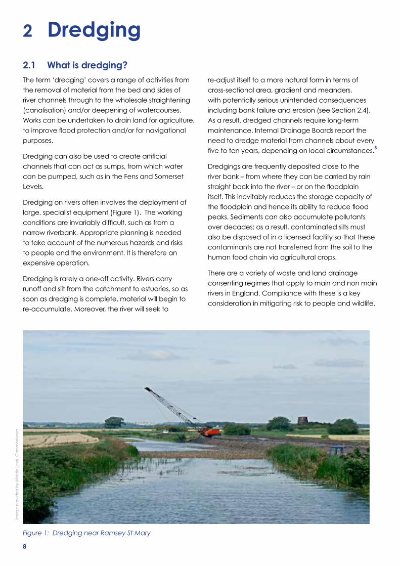
Dredgingonriversofteninvolvesthedeploymentof
large, specialist equipment (Figure 1). The working
conditionsareinvariablydifficult,suchasfroma
narrow riverbank. Appropriate planning is needed
totakeaccountofthenumeroushazardsandrisks
to people and the environment. It is therefore an
expensive operation.
Dredgingisrarelyaone-offactivity.Riverscarry
runoff and silt from the catchment to estuaries, so as
soon as dredging is complete, material will begin to
re-accumulate. Moreover, the river will seek to
re-adjust itself to a more natural form in terms of
cross-sectional area, gradient and meanders,
with potentially serious unintended consequences
including bank failure and erosion (see Section 2.4).
As a result, dredged channels require long-term
maintenance.InternalDrainageBoardsreportthe
need to dredge material from channels about every
fivetotenyears,dependingonlocalcircumstances.5
Dredgingsarefrequentlydepositedclosetothe
river bank – from where they can be carried by rain
straightbackintotheriver–oronthefloodplain
itself. This inevitably reduces the storage capacity of
thefloodplainandhenceitsabilitytoreduceflood
peaks. Sediments can also accumulate pollutants
overdecades;asaresult,contaminatedsiltsmust
also be disposed of in a licensed facility so that these
contaminants are not transferred from the soil to the
human food chain via agricultural crops.
There are a variety of waste and land drainage
consenting regimes that apply to main and non main
rivers in England. Compliance with these is a key
consideration in mitigating risk to people and wildlife.
Figure 1: Dredging near Ramsey St Mary
Ima
ge
pro
vid
ed
by
Mid
dle
Le
vel C
om
miss
ion
ers
8

9
2.2 Can dredging prevent all floods?Dredgingisusuallydeployedtoalleviatefloodingwhich
originatesfromariveroritsimmediatefloodplain.It
is not usually a tool that can help alleviate or reduce
theriskofotherkindsorsourcesoffloodingmentioned
earlier,e.g.surfacewaterfloodingorsewerflooding,
thoughthesedifferenttypesoffloodwaterscan
intermingleandthusexacerbateflooding.
Atypicalcrosssectionthroughariveranditsfloodplain
isshowninFigure2,below.Undernormalflow
conditions, the river is contained entirely within the
mainchannel.Theflowcapacityofmostnaturalriver
channelsisknownasthebankfulldischarge.Anyflowin
excess of the bankfull discharge will result in overtopping
of the banks – they only rarely ‘burst’. Initially, water
tendstolieonthefloodplain,whichactsasawater
store. But as the depth of the water increases, it starts to
flowoverthefloodplain;thespeedanddepthofthat
flowisinfluencedbyembankments,hedgesandother
features.
The Flood Estimation Handbook 6 suggests that river
flowintheUKtypicallyexceedsthebankfulldischarge
approximately every other year, although some
naturalandartificialwetlandsfloodannually,creating
conditions for specialist habitats and species. On that
Figure 2: Natural river channels
Natural River Channels
• Theriverchannelisnotlargeenoughtocontainextremefloods,evenafterdredging
• DredgingoftheriverchannelsdoesNOTpreventfloodingduringextremeriverflows
Floodplain
Channel
Extremefloodlevel
basis,thesightofwateronfloodplainsisactuallyquite
commonplace and is no cause for concern, unless it
impacts upon people or property.
Itiswhenthefloodflowissufficientlyhighandthe
floodextentsufficientlywideanddeepastoimpact
on the lives and livelihoods of people and businesses
thattheneedforfloodmanagementcomesintoplay.
Forpeoplewholiveandworkonfloodplains,floodrisk
management is a real and pressing issue.
Duringanextremeflood,thepeakriverflowmaybe
many times the bankfull discharge.7Duringlarge
events the storage provided by the river channel is
typicallyinsignificantwhencomparedtothatheldinthe
floodplainasseen,forexample,inthefloodingofthe
River Thames in January and February 2014.
It is simply not practical to contemplate dredging of
thechannel(letalonethefloodplain)totheextentthat
wouldberequiredtoconfinesuchlargeandrareflood
flowsfromthewiderfloodplain,sincethestorageand
conveyance capacity of the channel is a small fraction
ofthatofthewiderfloodplain.Inthisrespect,dredging
cannotpreventflooding.

Figure 3: Reduction in flood levels at Hinksey due to dredging
10
At the Hinksey pilot site, in Oxfordshire, dredging led to
areductioninwaterlevelof120mmwhenflowswere
confinedtothemainchannel(Figure3).However,
the reduction in top water level was only 40mm in
extremeflowsthatextendedontothefloodplain.Thisis
becauseinextremefloodconditions,waterlevelsare
increasingly controlled by major features like bridges
andobstructionsonthefloodplain,ratherthanbythe
capacity and shape of the channel. This is discussed in
relation to the Somerset Levels, in section 3.2.
In reference to the dredging pilots in Somerset, the
NorthandSouthdrainsarechannelswhoseoutflow
is limited by the pumping station capacity at the
downstream end. These drains are useful examples as
they are typical of channels where dredging activity is
undertakenbyInternalDrainageBoards.Thefindings
are qualitative, but support the view that the work
has increased the conveyance within the drains and
improvedtheevacuationoffloodwaterwithinthe
drainage catchment.
Of the three other sites in the pilot, the maintenance
ofBurstwickDrainincreasedtheconveyanceofthe
drain, though with only small reductions in water
levelsandnosignificantreductioninfloodrisk.The
workontheRiverWindrushwasidentifiedasleading
toapotentialincreaseinfloodriskdownstream
of the dredged reach, which necessitated further
consultations.
1 in 50 year return period event maximum water level (pre dredging) 55.74m
1 in 50 year return period event maximum water level (post dredging) 55.7m
1 in 5 year return period event maximum water level (post dredging) 55.11m
Pre dredging channelprofile
Post dredging channelprofile
Drop in water level due to dredging work: – 1 in 5 yr return period event = 120mm – 1 in 50 yr return period event = 40mm Notes
Datasource:HinkseyStreammodellingcrosssection2.020AlllevelsareAOF(AboveOrdnanceDatum)
1 in 5 year return period event maximum water level (pre dredging) 55.23m
2.3 Can dredging reduce flooding?Dredgingofareach(lengthofchannel)resultsinan
increase in the cross sectional area (and hence its
volume), as well as a reduction in the roughness of
the channel. Where dredging is used to straighten
and canalise the river, the effect is to reduce its
length and so increase channel gradient. These
effectscanincreasetheefficiencyofthechannel
in moving water (increasing the conveyance).
Dredgingshouldthereforeleadtoareductionin
waterlevelsandhencetoareductioninfluvialflood
frequency in the immediate area.
Whentheflowrateisimpededbychannelconstriction
(e.g. by a bridge) or high downstream water levels
(e.g. from tide locking, backwater ponding above
flowjunctionsandin-channelstructures,orpumping
restrictions),dredgingmayprovidenobenefitduring
extreme events.
Moreover, in coastal areas there may be some
trade-offbetweenimprovingconveyanceoffluvial
floodwatersandincreasingriskfromtidalfloods,as
has been modelled on the Parrett.8
The Environment Agency has undertaken a pilot
study to learn more about the advantages and
disadvantages of dredging.9 Six sites were used
in the pilot, which included the use of physical
maintenance and computer modelling.
11
Many parts of these arterial drainage schemes have
been neglected in recent decades as government
support has dwindled. While it is unlikely we will see
an expansion of new major drainage works, it is clear
thatreturningthesesystemstofullefficiencythrough
maintenance dredging could have dangerous
unintended consequences downstream.
2.4.2 Erosion
The natural form of a river system is intimately linked to
the energy of the water, known as stream power. This
energydictatestheerosivepoweroftheflowandthe
river’s capacity to transport sediment. Stream power is
dependent upon the channel shape, steepness and
flow.
Inhighenergysystems,thegreaterhydraulicefficiency
ofdredgedchannelscansignificantlyincreasestream
power. This can reach the point where it causes
bankfailureresultinginsignificantsedimentation
and the need for further maintenance. Alternatively,
bank protection works may be engineered into
the schemes, destroying the natural ability of the
channeltore-adjustinresponsetochangesinflow
and sediment rates. Higher stream energy can also
lead to coarse sediment, like gravels, being deposited
downstream of the dredged river reach. Counter-
intuitively, building higher banks can also increase
thedestructiveforcesoffloodwaterbypreventing
waterfromspillingontofloodplainsandslowingdown,
dissipating its energy. This exacerbates both the
potential for erosion and the damage caused by the
interruption of sediment supply.
In low energy systems, the river tends to adjust by
accumulating sediment, reducing channel capacity
in the dredged river reach and thus requiring ongoing
maintenance.
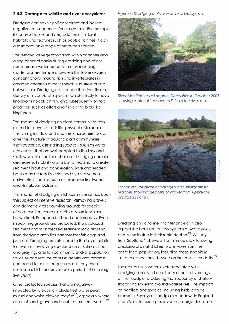
The indirect impacts of dredging on river channels
have been understood for decades. For example,
the effects can occur upstream of the dredged
reach, as the river seeks to return to a more natural
gradient.Thesepointsarewellillustratedinaflume
study videoed by the Wild Trout Trust (http://www.
youtube.com/watch?v=OAZ_BuyM41s)15, and in the
photographs shown in Figure 4. Erosion can be a major
hazardforinfrastructuresuchasbridges,wherethey
become pinch points.
While the impacts are well known they are the result of
anextremelycomplexinterplayoffactorsanddifficult
to predict.16
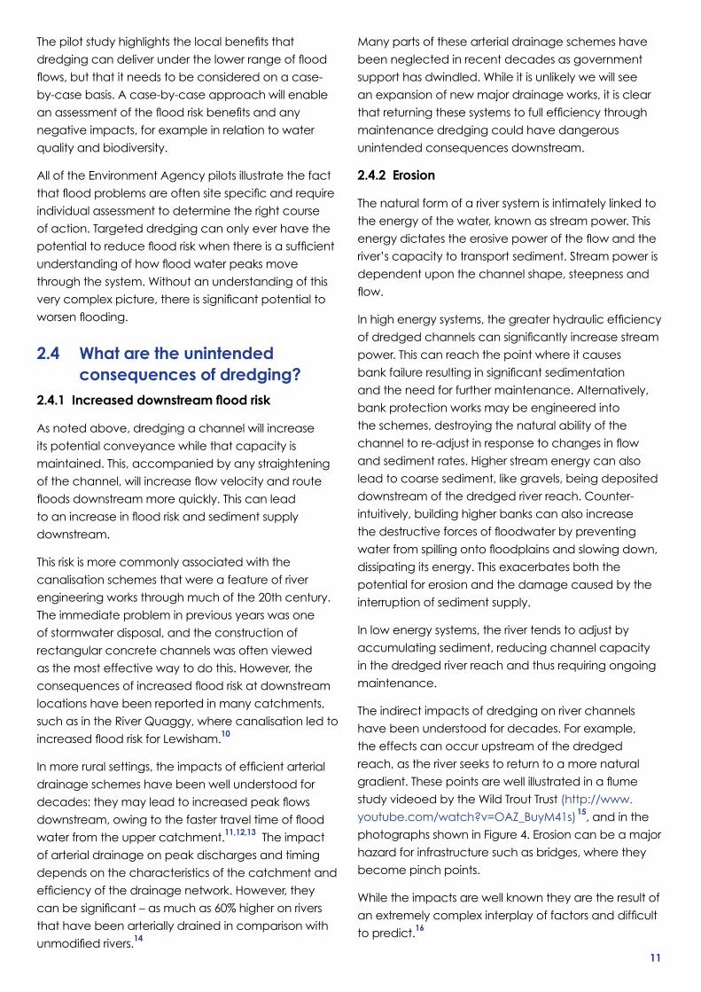
Thepilotstudyhighlightsthelocalbenefitsthat
dredgingcandeliverunderthelowerrangeofflood
flows,butthatitneedstobeconsideredonacase-
by-case basis. A case-by-case approach will enable
anassessmentofthefloodriskbenefitsandany
negative impacts, for example in relation to water
quality and biodiversity.
All of the Environment Agency pilots illustrate the fact
thatfloodproblemsareoftensitespecificandrequire
individual assessment to determine the right course
of action. Targeted dredging can only ever have the
potentialtoreducefloodriskwhenthereisasufficient
understandingofhowfloodwaterpeaksmove
through the system. Without an understanding of this
verycomplexpicture,thereissignificantpotentialto
worsenflooding.
2.4 What are the unintended consequences of dredging?
2.4.1 Increased downstream flood risk
As noted above, dredging a channel will increase
its potential conveyance while that capacity is
maintained. This, accompanied by any straightening
ofthechannel,willincreaseflowvelocityandroute
floodsdownstreammorequickly.Thiscanlead
toanincreaseinfloodriskandsedimentsupply
downstream.
This risk is more commonly associated with the
canalisation schemes that were a feature of river
engineering works through much of the 20th century.
The immediate problem in previous years was one
of stormwater disposal, and the construction of
rectangular concrete channels was often viewed
as the most effective way to do this. However, the
consequencesofincreasedfloodriskatdownstream
locations have been reported in many catchments,
such as in the River Quaggy, where canalisation led to
increasedfloodriskforLewisham.10
Inmoreruralsettings,theimpactsofefficientarterial
drainage schemes have been well understood for
decades:theymayleadtoincreasedpeakflows
downstream,owingtothefastertraveltimeofflood
water from the upper catchment.11,12,13 The impact
of arterial drainage on peak discharges and timing
depends on the characteristics of the catchment and
efficiencyofthedrainagenetwork.However,they
canbesignificant–asmuchas60%higheronrivers
that have been arterially drained in comparison with
unmodifiedrivers.14
12
River Manifold near Longnor, Derbyshire in October 2007 showing material “excavated” from the riverbed.
Erosion downstream of dredged and straightened reaches showing deposits of gravel from upstream, dredged sections.
Figure 4: Dredging of River Manifold, Derbyshire
(ph
oto
s: T
. Ja
ckl
in)
2.4.3 Damage to wildlife and river ecosystems
Dredgingcanhavesignificantdirectandindirect
negative consequences for ecosystems. For example,
it can lead to loss and degradation of natural
habitatsandfeaturessuchaspoolsandriffles.Itcan
also impact on a range of protected species.
The removal of vegetation from within channels and
along channel banks during dredging operations
can increase water temperature by reducing
shade:warmertemperaturesresultinloweroxygen
concentrations,makingfishandinvertebratesin
dredged channels more vulnerable to stress during
hotweather.Dredgingcanreducethediversityand
density of invertebrate species, which is likely to have
knock-onimpactsonfish,andsubsequentlyontop
predatorssuchasottersandfish-eatingbirdslike
kingfishers.
The impact of dredging on plant communities can
extend far beyond the initial physical disturbance.
Thechangeinflowandchannelcharacteristicscan
alter the structure of aquatic plant communities
that recolonise, eliminating species – such as water
crowfoots–thatarewelladaptedtotheflowand
shallowwaterofnaturalchannels.Dredgingcanalso
decrease soil stability along banks, leading to greater
sediment input and bank erosion. Bare and eroded
banks may be readily colonised by invasive non-
native plant species, such as Japanese knotweed
and Himalayan balsam.
Theimpactofdredgingonfishcommunitieshasbeen
the subject of intensive research. Removing gravels
can damage vital spawning grounds for species
of conservation concern, such as Atlantic salmon,
brown trout, European bullhead and lampreys. Even
if spawning grounds are protected, the displaced
sediment and/or increased sediment load resulting
fromdredgingactivitiescansmotherfisheggsand
juveniles.Dredgingcanalsoleadtothelossofhabitat
forjuvenileflow-lovingspeciessuchassalmon,trout
andgrayling,alterfishcommunityand/orpopulation
structureandreducetotalfishdensityandbiomass
compared to non-dredged areas. It may even
eliminateallfishforconsiderableperiodsoftime(e.g.
fiveyears).
Other protected species that are negatively
impacted by dredging include freshwater pearl
musselandwhite-clawedcrayfish17, especially where
areas of sand, gravel and boulders are removed.18,19
Dredgingandchannelmaintenancecanalso
impact the bankside burrow systems of water voles,
and is implicated in their rapid decline.20 A study
from Scotland21 showed that, immediately following
dredging of small ditches, water voles from the
entire local population, including those inhabiting
untouched sections, showed an increase in mortality.22
The reduction in water levels associated with
dredging can also dramatically alter the hydrology
ofthefloodplain,reducingthefrequencyofshallow
floodsandloweringgroundwaterlevels.Theimpacts
on habitats and species, including birds, can be
dramatic.SurveysoffloodplainmeadowsinEngland
and Wales, for example, revealed a large decrease
13
in breeding wading birds like redshank, lapwing and
snipe between 1982 and 2002, with snipe declining by
62% and redshank by 29%. Sample surveys since 2002
and the Bird Atlas 2007-11 indicate that these declines
have continued, with the remaining birds restricted to
a tiny number of suitable sites.23
2.4.4 Reduction in water quality
Dredgingcanalsoimpactonwaterquality,primarily
because of the suspension of sediments during and
after the operation. These impacts are generally
short-term, and in smaller ditches may be managed
by placing physical barriers such as hay bales in the
channel to prevent sediment affecting a long stretch.
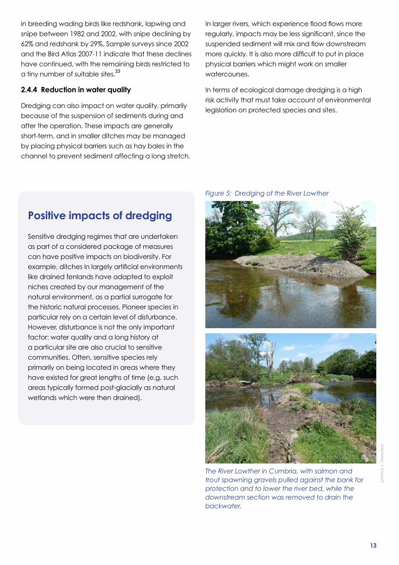
Figure 5: Dredging of the River Lowther
(ph
oto
s: L
. Gre
asle
y)
The River Lowther in Cumbria, with salmon and trout spawning gravels pulled against the bank for protection and to lower the river bed, while the downstream section was removed to drain the backwater.
Positive impacts of dredging
Sensitive dredging regimes that are undertaken
as part of a considered package of measures
can have positive impacts on biodiversity. For
example,ditchesinlargelyartificialenvironments
like drained fenlands have adapted to exploit
niches created by our management of the
natural environment, as a partial surrogate for
the historic natural processes. Pioneer species in
particular rely on a certain level of disturbance.
However, disturbance is not the only important
factor:waterqualityandalonghistoryat
a particular site are also crucial to sensitive
communities. Often, sensitive species rely
primarily on being located in areas where they
have existed for great lengths of time (e.g. such
areas typically formed post-glacially as natural
wetlands which were then drained).
Inlargerrivers,whichexperiencefloodflowsmore
regularly,impactsmaybelesssignificant,sincethe
suspendedsedimentwillmixandflowdownstream
morequickly.Itisalsomoredifficulttoputinplace
physical barriers which might work on smaller
watercourses.
In terms of ecological damage dredging is a high
risk activity that must take account of environmental
legislation on protected species and sites.
14
3 Flooding 3.1 Recent floodingTheUKhasbeenina‘flood-rich’periodsinceEaster
1998(seeTable1forasummaryofsomerecentflood
events).Therehavebeenflood-richperiodsbefore,
according to compilations such as the Chronology
of British Hydrological Events. That said, recent years
have also witnessed a succession of droughts,
including the deep drought of 2010-2012, illustrating
the extremes of weather that are not uncommon
intheUK.
Forthosethathavebeenaffectedbyflooding,
orrepeatedflooding,theexperienceisoften
devastating. Whilst not diminishing the plight of those
thathavesufferedflooding,weshouldnotforgetthat
floodriskmanagementhassparedmillionsthecosts
andstressoffloodingthattheywouldotherwisehave
experienced.Forexample:
• The North Sea was subject to a storm surge in
December2013,whichraisedwaterlevelsto
two metres above Highest Astronomical Tide at
Table 1: Summary of recent flood events
Date Areas affected
Easter 1998 R. Nene, R. Avon, Warwickshire
Autumn 2000 Southern England, Midlands, Yorkshire
January 2003 R.Thames(stillonly12thhighestinseriesfrom1883atKingston)
August 2004 Boscastle
January 2005 Carlisle
Summer 2007 Midlands, Southern England, NE England
October 2008 OtteryStMary(Devonrecord3-hourstorm)
November 2009 Cumbria (including record 24-hour rainfall, a total of 316.4 mm)
November 2010 Cornwall
Summer 2012 ExtensivesurfacewaterfloodinginUK
December 2013 North Sea surge (800,000 properties protected)
Winter 2014 Somerset Levels, R. Thames
Note that this is an illustrative list and by no means exhaustive
Lowestoft and gave rise to the highest surge since
thefloodsof1953.However,thedamagewasfar
lessthanin1953,confirmingthevalueofextensive
defences along the East Coast and Thames
Estuary, including the Thames Barrier.
• Nottinghamfloodalleviationschemeopenedin
September 2012, protecting 16,000 homes and
businesses.24
• Upton-upon-Severnfloodalleviationscheme,
openedinJuly2012comprisesapermanentflood
wall with glass panels for protecting the town centre.
• Banburyfloodalleviationschemecomprisesa
majorfloodstorageareathatprovidesprotection
to 440 homes, 70 businesses and transport
infrastructure.25
Planningpolicyhasevolvedsignificantlyinthepast
decade26, but some development does still take
placeonthefloodplains,evenwheretheEnvironment
Agencyhasobjectedonfloodriskgrounds.

15
There is an overriding need to address the legacy
of existing properties and areas that are at risk of
flooding.TheEnvironmentAgency’sfloodriskmaps
demonstrate the need for urgent action. One of these
legacy areas is the Somerset Levels.
3.2 The Somerset LevelsThe Somerset Levels are served by four main rivers
– the Parrett, Tone, Brue and Axe, which together,
drain water from a surrounding catchment of over
200,000ha(Figure6).Thefloodplain,whichislargely
freshwater and covers around 60,000ha, is generally
veryflat.TheRiverParrett,forexample,fallsbyonly
30cm between Langport and Bridgwater, a distance
of about 18.5km. The Parrett and Tone are tidally
influenceduptoaround30kminland,withtidalsluice
gates at Oath Lock and New Bridge respectively. This
tidalinfluencebringsasignificantamountofcoarsesilt
into the system on each tide.
Aflatlandscape,tidalincursionandfairlyheavy
rainfall combine annually to produce extensive
winterfloodingacrossmanypartsoftheLevels.
Winter rainfall increases soil moisture, leading to
diminishing permeability and increasing runoff in the
upper and middle catchment, and raising water
levels in the main rivers. In time, these may overtop
theirembankments,leadingtofloodingonthe
adjacent, lower-lying moors. High tide levels in the
Bristol Channel can also force tidal water farther
up the Parrett and Tone, causing overtopping of
embankments or reducing the ability of winter river
flowstobeconveyedouttoBridgwaterBay.
Floodplain water is evacuated into main rivers via
pumping stations on many moors. Critically, pumping
is only effective when water levels in the River Parrett
are low enough to take the additional water. At high
tide this can be problematic, since there is a shorter
period of time when pumping can occur. The Sowy
Riverfloodreliefchannel,whichwasdesignedto
providefloodrelieftoLangport,alsotakesflowsfrom
the Parrett 1,500m downstream of the town. Water
in the Sowy is conveyed through gravity drainage
Figure 6: Flood risk map for Somerset
Palepinkwithredoutline:SomersetLevelsandMoorsJointCharacterArea
Lightblue:1:100floodextent© Natural England copyright 2014. Contains public sector information licensed under the Open Government Licence v1.0. © The Environment Agency copyright 2014. Contains Ordnance Survey data © Crown copyright and database right 2013
16
intoKing’sSedgemoorDrain.Thisthendrainsintothe
Parrett Estuary downstream of Bridgwater.
Annualwinterfloodsandhighfieldditchwaterlevels,
managed to provide summer irrigation for livestock,
have helped create a rich biodiversity within the
Level’sfloodplain.Asaresult,theSomersetLevelsand
Moors have been designated as a Special Protection
Area for their winter birds and a Ramsar Wetland of
International Importance. Many of the moors are also
SitesofSpecialScientificInterest.Theseinternationally
importanthabitatsdependonregularfloodingand
high water tables for their conservation.
Majorfloodinginthecatchmenthasoccurred
many times since its reclamation, with recent
notable events in 1919, 1966, 2000, 2012, and now
mostrecentlyin2014.The1919floodssaw28,000ha
inundated compared to 6,500ha at the time of
writing.ThesecondhalfofDecember2013sawa
significantamountofrainfallinSouthWestEngland,
withtheMetOffice’sHadleyCentrerecordinga
maximumof37mminasingledayon23rdDecember
2013. This led to the Parrett and Tone catchments
being widely saturated and already conveying
significantflows.
The wet weather continued in early January 2014,
which coincided with high spring tides in the Bristol
Channel. The combination of conditions (i.e.
saturated upland and lowland catchments), high
riverflows,extremerainfallandhightides,ledtothe
riversovertoppingtheirbanksandwaterflooding
across the moors. Continued wet weather and high
tideshasseencontinuousfloodingforsixweeks.
3.3 Would dredging have helped to reduce the extent or the duration of flooding?
In recent years, the Environment Agency has
undertaken a number of feasibility studies into
potential dredging of the tidal sections of the
River Parrett and Tone catchments. In particular, it
examined a number of potential dredging scenarios
for these tidal sections, including assessments of
the impacts of dredging different stretches of the
rivers, different amounts of sediment removal and
comparison of the impacts of agitation dredging
verses complete removal of the sediment. The studies
includedhydraulicmodelling,cost-benefitanalyses
and environmental assessments.
The hydraulic models demonstrated that dredging
didnotlowerpeakfloodlevelssignificantlyforwinter
storms (e.g. a 140mm drop at Curry Moor for a 1
in100yearevent).Thisisduetofloodlevelsbeing
determined primarily by the height of the river banks.
Therefore, it is highly unlikely that dredging of the
Parrett and Tone prior to the January 2014 floods
would have led to a significant drop in the flood levels
experienced.
However, the models do demonstrate that dredging
tidal sections of the two rivers would lead to a
significantreductioninthedurationoffloodevents.
This is because dredging leads to an increase in river
conveyance.Themainbenefitofthisisthatpumping
can remove greater amounts of water from the moors
afterthefloodpeakhaspassed.Themodellingstudies
suggest that if dredging of the tidal sections of the
Parrett and Tone had occurred prior to the November
2012event,thenthedurationoffloodingwouldhave
been cut from 54 to 24 days on Curry Moor. Therefore,
it is highly likely that dredging the Parrett and Tone
prior to the January 2014 floods would have led to a
reduction in the flood duration experienced.

17
From Environment Agency studies, it is clear that the
geographicalextentofanybenefitsfromadredge
vary according to the dredging regime employed.
TheextentofanyfloodingexperiencedatMuchelney,
forexample,isunlikelytobesignificantlyaffectedby
dredging,althoughdeepfloodingislikelytooccurfor
a shorter period. There is a suggestion in the studies
that dredging would reduce the frequency at which
AthelneySpillwayovertopsandthereforetheflooding
of the A361. The relatively large difference in bed
levels between the Levels and upstream Taunton
meanthatdredgingwillnotaffectflooding
in Taunton.
ImprovingfloodwaterconveyancefromtheLevels
floodplainthroughdredgingpassesadditionalwater
downstream,whichcanraisefloodlevelsclose
to vulnerable settlements and infrastructure. For
example, the hydraulic modelling suggests that river
floodlevelswouldriseinBridgwaterifdredgingwasto
occur. However, the predicted tidal levels for a similar
likelihood of event (e.g. annual chance of 1%) are
higher than the river levels. Therefore, the argument
is made that although river levels in Bridgwater would
rise if dredging occurs, the defences are in place
toallowthistohappenwithoutincreasingfloodrisk
in the town. It is not known if exposing defences to
high water levels more often will have an impact on
maintenance or structural integrity.
It should be noted that the Environment Agency
studiesdemonstrateanincreaseintidalfloodrisk
totheLevelsfromdredging,althoughflooding
associated with these types of events is usually much
shorter-lived.
As outlined in this report, dredging has environmental
risks associated with the removal of habitats,
increased turbidity (i.e. reduced transparency of the
water) and potential for contaminant mobilisation.
That said, many wildlife groups accept the risks of
the planned dredge can be mitigated. However,
thedredgingdoesnotqualifyforsignificantcentral
government funding under current Treasury rules, due
tothe(relatively)lowbenefitsobtainedcomparedto
investinginfloodmanagementschemeselsewherein
the country.
18
4 Approaches to flood risk management
In response, the Environment Agency led a stakeholder
engagement programme to develop a common
understanding of techniques that work with natural
processes (see Table 2) along with examples of their
implementation.
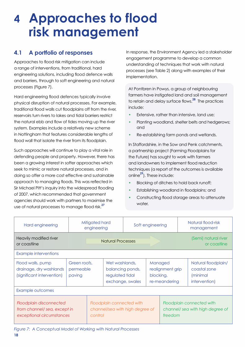
4.1 A portfolio of responsesApproachestofloodriskmitigationcaninclude
a range of interventions, from traditional, hard
engineeringsolutions,includingflooddefencewalls
and barriers, through to soft engineering and natural
processes (Figure 7).
Hardengineeringflooddefencestypicallyinvolve
physical disruption of natural processes. For example,
traditionalfloodwallscutfloodplainsofffromtheriver,
reservoirs turn rivers to lakes and tidal barriers restrict
thenaturalebbandflowoftidesmovinguptheriver
system. Examples include a relatively new scheme
in Nottingham that features considerable lengths of
floodwallthatisolatetheriverfromitsfloodplain.
Such approaches will continue to play a vital role in
defending people and property. However, there has
been a growing interest in softer approaches which
seek to mimic or restore natural processes, and in
doing so offer a more cost effective and sustainable
approachtomanagingfloods.Thiswasreflectedin
SirMichaelPitt’sinquiryintothewidespreadflooding
of 2007, which recommended that government
agencies should work with partners to maximise the
useofnaturalprocessestomanagefloodrisk.27
Figure 7: A Conceptual Model of Working with Natural Processes
Flood walls, pump
drainage, dry washlands
(significantintervention)
Green roofs,
permeable
paving
Wet washlands,
balancing ponds,
regulated tidal
exchange, swales
Managed
realignment grip
blocking,
re-meandering
Naturalfloodplain/
coastalzone
(minimal
intervention)
Hard engineering
Mitigated hard Soft engineering
Naturalflood-risk engineering management
Example interventions
Example outcomes
Floodplain disconnected
from channel/ sea, except in
exceptional circumstances
Floodplain connected with
channel/sea with high degree of
control
Floodplain connected with
channel/ sea with high degree of
freedom
HeavilymodifiedriverNatural Processes
(Semi) natural river or coastline or coastline
At Pontbren in Powys, a group of neighbouring
farmers have instigated land and soil management
toretainanddelaysurfaceflows.28 The practices
include:
• Extensive,ratherthanintensive,landuse;
• Plantingwoodland,shelterbeltsandhedgerows;and
• Re-establishing farm ponds and wetlands.
In Staffordshire, in the Sow and Penk catchments,
a partnership project (Farming Floodplains for
the Future) has sought to work with farmers
andlandownerstoimplementfloodreduction
techniques (a report of the outcomes is available
online29).Theseinclude:
• Blockingofditchestoholdbackrunoff;
• Establishingwoodlandinfloodplains;and
• Constructingfloodstorageareastoattenuate
water.
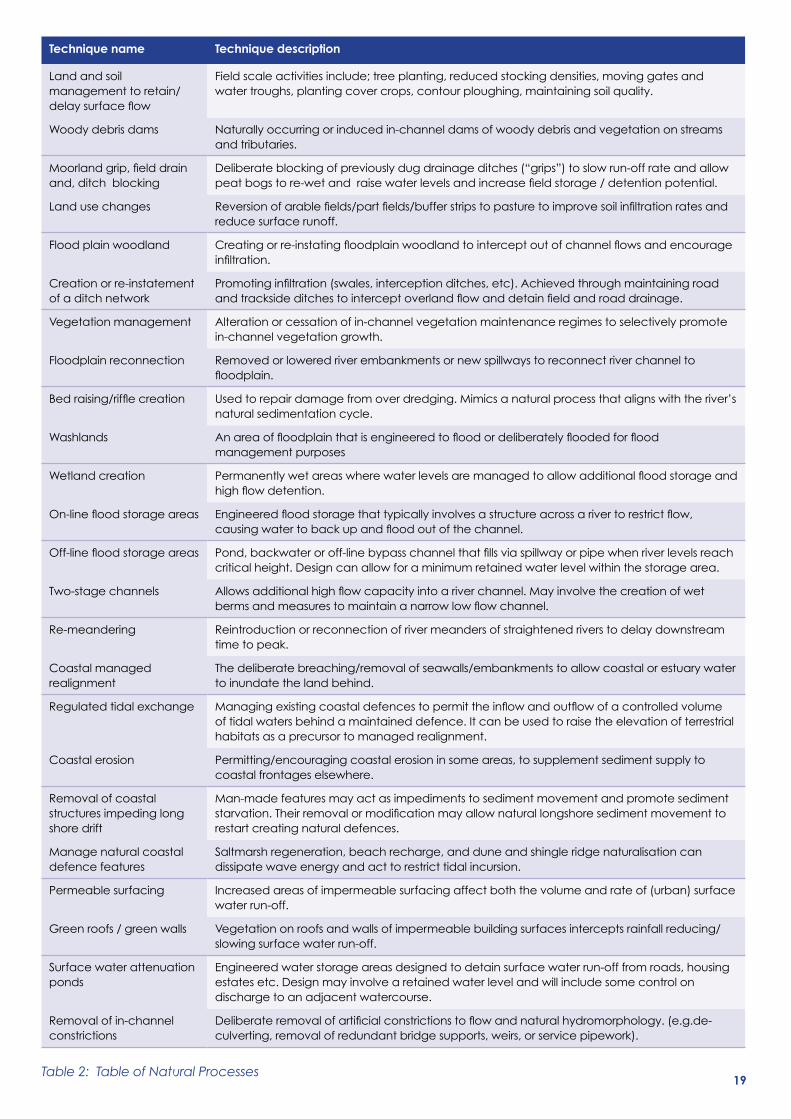
Table 2: Table of Natural Processes
Technique name Technique description
Land and soil management to retain/delaysurfaceflow
Fieldscaleactivitiesinclude;treeplanting,reducedstockingdensities,movinggatesandwater troughs, planting cover crops, contour ploughing, maintaining soil quality.
Woody debris dams Naturally occurring or induced in-channel dams of woody debris and vegetation on streams and tributaries.
Moorlandgrip,fielddrainand, ditch blocking
Deliberateblockingofpreviouslydugdrainageditches(“grips”)toslowrun-offrateandallowpeatbogstore-wetandraisewaterlevelsandincreasefieldstorage/detentionpotential.
Land use changes Reversionofarablefields/partfields/bufferstripstopasturetoimprovesoilinfiltrationratesandreduce surface runoff.
Flood plain woodland Creatingorre-instatingfloodplainwoodlandtointerceptoutofchannelflowsandencourageinfiltration.
Creation or re-instatement of a ditch network
Promotinginfiltration(swales,interceptionditches,etc).Achievedthroughmaintainingroadandtracksideditchestointerceptoverlandflowanddetainfieldandroaddrainage.
Vegetation management Alteration or cessation of in-channel vegetation maintenance regimes to selectively promote in-channel vegetation growth.
Floodplain reconnection Removed or lowered river embankments or new spillways to reconnect river channel to floodplain.
Bedraising/rifflecreation Usedtorepairdamagefromoverdredging.Mimicsanaturalprocessthatalignswiththeriver’snatural sedimentation cycle.
Washlands Anareaoffloodplainthatisengineeredtofloodordeliberatelyfloodedforfloodmanagement purposes
Wetland creation Permanentlywetareaswherewaterlevelsaremanagedtoallowadditionalfloodstorageandhighflowdetention.
On-linefloodstorageareas Engineeredfloodstoragethattypicallyinvolvesastructureacrossarivertorestrictflow,causingwatertobackupandfloodoutofthechannel.
Off-linefloodstorageareas Pond,backwateroroff-linebypasschannelthatfillsviaspillwayorpipewhenriverlevelsreachcriticalheight.Designcanallowforaminimumretainedwaterlevelwithinthestoragearea.
Two-stage channels Allowsadditionalhighflowcapacityintoariverchannel.Mayinvolvethecreationofwetbermsandmeasurestomaintainanarrowlowflowchannel.
Re-meandering Reintroduction or reconnection of river meanders of straightened rivers to delay downstream time to peak.
Coastal managed realignment
The deliberate breaching/removal of seawalls/embankments to allow coastal or estuary water to inundate the land behind.
Regulated tidal exchange Managingexistingcoastaldefencestopermittheinflowandoutflowofacontrolledvolumeof tidal waters behind a maintained defence. It can be used to raise the elevation of terrestrial habitats as a precursor to managed realignment.
Coastal erosion Permitting/encouraging coastal erosion in some areas, to supplement sediment supply to coastal frontages elsewhere.
Removal of coastal structures impeding long shore drift
Man-made features may act as impediments to sediment movement and promote sediment starvation.Theirremovalormodificationmayallownaturallongshoresedimentmovementtorestart creating natural defences.
Manage natural coastal defence features
Saltmarsh regeneration, beach recharge, and dune and shingle ridge naturalisation can dissipate wave energy and act to restrict tidal incursion.
Permeable surfacing Increased areas of impermeable surfacing affect both the volume and rate of (urban) surface water run-off.
Green roofs / green walls Vegetation on roofs and walls of impermeable building surfaces intercepts rainfall reducing/slowing surface water run-off.
Surface water attenuation ponds
Engineered water storage areas designed to detain surface water run-off from roads, housing estatesetc.Designmayinvolvearetainedwaterlevelandwillincludesomecontrolondischarge to an adjacent watercourse.
Removal of in-channel constrictions
Deliberateremovalofartificialconstrictionstoflowandnaturalhydromorphology.(e.g.de-culverting, removal of redundant bridge supports, weirs, or service pipework).
19
20
Theuseofprocessesforslowingtheflowhavebeen
commonplace in dealing with runoff from urban
developments for many years. The use of soakaways,
swalesandbasinsforinfiltrationorattenuationare
all used in drainage design to attenuate runoff from
developmentstopre-developmentorgreenfield
ratesofrunoff.TheCIRIASuDSmanualandtheWWT/
RSPB guidance provide comprehensive guidance for
different methods.30
In the River Quaggy in Sutcliffe Park in London, a
localactiongroupinfluencedthedesignofaflood
alleviationschemesothatitnowfeatures:
• Floodplainreconnectionandwetlandcreation;
• Two-stage channels and re-meandering of
rivers;and
• Off-linefloodstorageareas.
4.2 Managing land useLandisthekeyresourceinanydebateoverflooding
and it is under pressure. Land is in demand for housing,
business, agriculture, leisure activity and for broader
environmental needs. Land use management via the
planningsystemalsoprovidesopportunitiesforflood
risk management, either for storing water in times of
flood,orbyholdingwaterbacktoreduceflooding.
The tensions between competing land uses in relation
tofloodriskarereflectedinthelandzoningthatlies
at the heart of national planning policy guidance.
Developmentinareasathighriskoffloodingis
discouraged through the policy, to protect the
proposeddevelopmentfromfloodingaswellasto
ensure that others are not adversely affected by
flooding.Despitethis,somenewdevelopmentisstill
undertakenonfloodplainswheretheEnvironment
Agencyhasobjectedonfloodriskgrounds,and
it is important that inappropriate development on
floodplainsisproperlycontrolled.
In Montgomeryshire, the Pumlumon Project31 is working with local farmers, foresters and tourism businesses
across150squaremilesoftheCambrianmountains,changinguplandmanagementtoreduceflooding,as
wellasboostingthelocaleconomy,improvingcarbonstorageandsupportingwildlife,by:
• Blockingditchesthatdrainpeatbogs;
• Restoringacidgrassland,hedgerowsanduplandwoodland;
• Improvinginfiltrationbychanginggrazingregimes,reducingstockingdensitiesandplantingbroadleaf
trees;and
• Buffering rivers and streams.
InthePeakDistrict,theMakingSpaceforWaterproject32 is restoring degraded moorland to retain water on
thelandby:
• Blockingerosiongullies;and
• Re-establishing vegetation on bare soils.
In Pickering, in North Yorkshire, the Slowing the Flow Pickering project33 is working to reduce the frequency of
futurefloodsinPickering,aswellasdeliveringarangeofotherenvironmentalandcommunitybenefits,by:
• Constructinglowlevelembankments;
• Creatingriparianandfloodplainwoodland;
• Restoringalargewoodydebrisdam;
• Undertakingfarm-scaletargetedplantingandthecreationofinfiltrationbasins;
• Blockingmoorlanddrains;
• Establishingno-burnzonesalongmoorlandstreams;and
• Restoringstreamsidebufferzonesalongforeststreams.
21
There is an extensive legacy of historical development
inareasatriskofflooding,althoughmostofthese
areas are protected by defences of some form. The
challenges for people living, working and managing
floodriskintheseareasareoftengreat.Inthe
shortterm,managingfloodriskisallaboutmaking
communitiesmore‘resilient’toflooding,through
warnings, provision of emergency support and use of
property and community protection schemes.
However, in the longer term, the strategy is more
challenging. Climate change projections indicate that
floodriskislikelytoincrease,duetorisingsealevels
and increased rainfall. There are also parts of the
country where it is considered uneconomic to defend
land and property, such as some farmland or small or
remote communities. In such locations, resilience to
floodingwillbevitaliftheircommunitiesstillwantto
live and work there. Shoreline Management Plans by
the Local Authorities and Environment Agency, e.g.
SuffolkCoastalDistrictCouncil,presentstrategiesfor
managed retreat for situations where it is deemed
uneconomic to maintain existing defences.34
Theincreasedthreatoffloodingwillpromptacall
for proactive strategies in more areas of the country.
Moreareaswillneedtobeidentifiedforstorageof
floodwatersandtoprotectdownstreamcommunities
(it should be noted that the Environment Agency
alreadyownsoroperatesmorethan800floodstorage
areas, but this requirement is likely to rise).
Thefocusisnotonlyonareasthatneedtobezoned
forstoringfloodwater;themanagementoflandin
catchments will also need to be reviewed in order to
slowtheflowofwaterdown.Someofthesemeasures
havealreadybeenidentifiedintheprevioussection,
includingfloodstorage,lessintensivegrazing,upper
catchment tree planting or ditch blocking, using CIRIA
guidanceonlandusemanagement,floodflowsand
sediments.35
Thewaythatthelandismanagediscrucialtoflood
risk management. It is also important to recognise
thattherearebenefitstowidersocietyfromflood
protection services which may be provided by
managing the land in a certain way.
However delivering changes in land management is
not straightforward, so engagement with residents,
landowners and land managers is a critical element
of any strategy.
Having the right tools is also vital. If a more holistic
approach is to work we will need clarity over
acceptable land use practices to both adapt to and
mitigatefloodrisk.Thismustincludeaclearbaseline
to avoid poor practices leading to increased runoff
water and soil washing into rivers, and ensuring good
managementleadingtohigherinfiltrationrates,as
well as targeted support for additional action. This
could be achieved by requiring higher standards of
soil and water protection in return for farm subsidies,
and effective use of regulation under the Water
FrameworkDirective.Inaddition,anewgenerationof
incentive schemes could provide targeted support to
farming systems and habitats that increase resilience
anddelivermultiplebenefitsfromland.
The decisions will not be easy and there will be
trade-offs to be achieved, but the kind of initiatives
identified(seesection4)provideamodelforsuccess
while the Catchment Based Approach provides a
framework for scaling up initiatives.36

22
Getting the best from our rivers by working with nature – an opinion pieceTony Juniper, environmental advisor,
writer and campaigner
MuchoftheUKgetsalotofrain,andthatiswhy we have more than 389,000 kilometres of river. Essential for the welfare of people nationwide, over the centuries these watery ribbons of life have become subject to growing pressure, not only because of what we have done to them directly but also because of changes in their catchments.
Ourbestrivers,thoseofficiallyrecognisedfortheirnature conservation value, are in a worse state than any other kind of similarly designated habitat in the country. Over-abstraction from rivers and ground water, pollution and physical damage are among the reasons. Nutrient input is an especially big problem that is often linked with soil loss.
Aconsequenceofallthisisreflectedinthebiologicalstate of our rivers. With under a quarter in the ‘good’ conditionrequiredbytheEU’sWaterFrameworkDirective,itisquiteobviousthatmuchmoreneedsto be done in bringing our rivers up to scratch so that they can do all the jobs we need them to do.
These include helping to supply water, permitting navigation, recreation, nature conservation and drainage. All of these services have a value in our crowded islands and we need to make sure we canoptimizehowbesttoachievethemall.Whatis evidently not an intelligent approach, however, is to make policies that place any one of the services above the others. But this is exactly what is in danger ofhappeninginthewakeofrecentfloods.
The inundation of farmland, houses and businesses has rekindled calls for more to be done to harness the drainage service provided by rivers through dredging their channels. It’s a policy that for many will appear superficiallyattractive.Buttearingoutthebedofariver, straightening its channel and de-vegetating its banks could hardly be more destructive, depriving a wide range of aquatic organisms of their habitat and intheprocessdeprivingsocietyofmanybenefits.
Reducingfloodriskneednotentailthiskindofenvironmental damage, however. An alternative approach is to look instead at how aspects of the water environment can be enhanced. Rivers are dynamic and constantly changing systems that are
closely linked with other features in the landscape, includingtheirfloodplainsandwidercatchments.There are, in any case, a host of studies that demonstrate that wholesale dredging has many unintended consequences and can often make downstreamflooding,more,notless,likely.
When taking this wider view it often becomes clear howfloodingislesslinkedtoanabsenceofdredgingand instead damage to the riverine environment. For example building houses or planting crops on floodplainsobviouslyinvitesincreasedfloodrisk.So does the loss of soil from the wider catchment. Causedbycultivationandgrazingpractices,soileroding from the land and entering rivers can lead to several environmental problems, including the silting up of riverbeds.
With all this in mind, it seems logical to consider how besttoreducefloodriskinthecontextofthewiderstate of our river environments and their catchments. By looking at low lying land differently, taking steps to slow down soil loss and through measures to restoreriverflowinthoseareassufferingfromover-abstraction, it would be possible to harness rivers for thefullsuiteofservicesandbenefitstheyprovidetosociety, rather than simply seeing them as a drain.
By taking this route, and avoiding the destructive impacts of dredging, it will be more likely that the UKwillonedaymeettherequirementsoftheEU’sWaterFrameworkDirective,anditsgoaltorestorethe health of surface waters. It is not a question of looking after the environment at the expense of people’s needs. By meeting the objectives in the Directive,notonlywouldwebemakinganimportantcontribution to conserving wildlife and enhancing the recreational value of rivers, we’d be adding to the nation’swatersecurityandreducingfloodrisktoo.
Making this shift toward enhancing the environment rather than causing damage to it will require a more joined up and integrated approach. Simplistic ‘solutions’ like dredging may command some populist support in the short-term, but going down that road is neither the most intelligent nor optimum course we can take.

23
5 GlossaryArterial drainage: a drainage system where
differentnumberofdrainsflowcollectivelyintoone
main channel.
Backwater ponding: where water levels are
influencedbydownstreamfactors–thesemay
include constrictions in the channel, high levels in a
tributary river, or the sea.
Bankfull discharge:theflowcapacityofnaturalriver channels.
Canalisation: the creation of regular channels
often including realignment to increase conveyance.
Conveyance: the theoretical capacity of a river
to carry water.
Drain:anartificiallycreatedchannelorpipe–oftenfor draining agricultural land.
Drainage catchment:anareaofartificiallydrainedland–generallydefinedbythedrainage
network, but can be affected by local water levels.
Dredging: the systematic removal of accumulated
material from river or other watercourse channels.
Desilting:theremovaloffinesiltandsedimentfrom
a watercourse.
Flow rate:theactualflowofwaterthroughariverat a given time.
Highest Astronomical Tide: the highest tide
level which can be predicted to occur under normal
meteorological conditions
Natural catchment: the land drained by a
streamorriver–generallydefinedbythetopography.
Reach: a length of channel.
Rhyne: a drainage ditch or canal, used to turn
areas of wetland at around sea level into pasture.
Sump:aninfiltrationbasinusedtomanagesurface
runoff water and recharge underground aquifers.
Stream power: the energy of a river.
Tide locking: the prevention or reversal of normal
riverflowduetohightidallevels.
24
1. SomersetDrainageBoardConsortium,‘DrainageBoard’s10-pointplantobeatfloodingonthelevels’,www.somersetdrainageboards.gov.uk/notice-board/drainage-boards-10-point-plan-to-beat-flooding-on-the-levels/.
2. EnvironmentAgency(2014)‘RiversandCoastalMaintenanceProgrammes2013-14’,www.environment-agency.gov.uk/homeandleisure/floods/109548.aspx.
3. LancasterUniversity(2008)Analysis of historical datasets to look for impacts of land use and management change on flood generation,DefracommissionedreportFD2120,http://randd.defra.gov.uk/Default.aspx?Menu=Menu&Module=More&Location=None&ProjectID=13972&FromSearch= Y&Publisher=1&SearchText=fd2120&SortString=ProjectCode&SortOrder=Asc&Paging=10.
4. MetOffice2014‘AGlobalPerspectiveontheRecentStormsandFloodsintheUK’,http://www.metoffice.gov.uk/research/news/2014/uk-storms-and-floods.
5. ADA,Dredging: the views and experience of Internal Drainage Boards,www.ada.org.uk/downloads/other/downloads_page/Dredging%20-%20the%20views%20and%20experience%20of%20IDBs.pdf.
6. Institute of Hydrology (1999) The Flood Estimation Handbook.
7. BasedontypicalUKfloodcharacteristicsoutlineintheFloodEstimationHandbook(The Flood Estimation Handbook).
8. Environment Agency (2013) Somerset Levels and Moors Asset Management Strategy Lower Tone and Parrett - Curry Moor and North Moor.
9. Environment Agency (2011) Dredging and Pilot Studies Report.
10. RiverQuaggyFloodAlleviationScheme,www.qwag.org.uk/quaggy/flood.php.
11. Newson,M.D.andRobinson,M.(1983)‘Effectsofagriculturaldrainageonuplandstreamflow:casestudiesinmid-Wales’,TheJournalofEnvironmentalManagement,17:333-48.
12. Robinson,M.andRycroft,D.W.,(1999)‘Theimpactofdrainageonstreamflow’,in:R.W.SkaggsandJ.vanSchilfgaarde(Editors),Agricultural Drainage.
13. Sear,D.,Wilcock,D.,Robinson,M.andFisher,K.(2000)‘RiverchannelmodificationintheUK’.inM.Acreman(Editor),The Hydrology of the UK, A Study of Change, pp.55-81.
14. Bailey,ADandBree,T.(1981)The effect of improved land drainage on river flood flows, in The Flood Studies Report, Five Years On, pp. 131-42.
15. ‘Unintendedconsequencesofdredging’.www.youtube.com/watch?v=OAZ_BuyM41s.
16. MathiasKondolfG.(1994)‘Geomorphicandenvironmentaleffectsofinstreamgravelmining’,LandscapeandUrbanPlanning,Volume28,Issues2–3,April 1994, pp. 225–243.
17. P.J.CosgroveaandL.C.Hastieb(2001)‘Conservationofthreatenedfreshwaterpearlmusselpopulations:rivermanagement,musseltranslocationandconflictresolution’,BiologicalConservationVolume99,Issue2,June2001,pp183–190.
18. StephaniePeay.Guidanceonworksaffectingwhite-clawedcrayfish(2000),ContractReference:EnglishNatureFIN/CON/139.
19. DuringtheEnvironmentAgencydredgingpilotstudies,freshwatermussels,foundintheNorthandSouthDrainsinSomersetwereremovedfromthechannel bed material and placed back into the drain following dredging.
20. The Water Vole is fully protected under Schedule 5 of the Wildlife and Countryside Act 1981 (as amended).
21. Telfer S (2000) The influence of dredging on water vole populations in small ditches (Scottish Natural Heritage commissioned report F99LF13).
22. Good practice guidance is available for mitigating the impacts on water vole of de-silting of small ditches (for example from the Environment Agency, theAssociationofDrainageAuthoritiesandlocalWildlifeTrusts)which,atsomesites,canbebeneficialinthelonger-term-forexamplebyopeningup previously de-silted ditches to increase water levels and extend habitat. All such works require adherence to the relevant legislation and careful assessment on a site-by-site basis.
23. BTO (2012) Bird Atlas 2007-11, www.bto.org/volunteer-surveys/birdatlas.
24. Gov.uk,‘Nation’sbiggestinlandflooddefenceopenedinNottingham’,www.gov.uk/government/news/nation-s-biggest-inland-flood-defence-opened-in-nottingham.
25. EnvironmentAgency,‘BanburyFloodAlleviationScheme’,www.environment-agency.gov.uk/homeandleisure/floods/124750.aspx.
26. RelevantpolicydocumentsincludePlanningPolicyGuidance25:DevelopmentandFloodRisk(PPG25)andPlanningPolicyStatement25:DevelopmentandFloodRisk(PPS25),whichhavebeenincorporatedintotheNationalPlanningPolicyFramework(NPPF).UndertheNPPF,newdevelopmentshouldbedirectedawayfromareasatriskofflooding,anddevelopmentsonthefringesoffloodplainsshoulddemonstrateatapplicationstagethattheyarebothsafeanddonotadverselyaffectthefloodriskforothers.
27. Pitt M. (2008) Learning lessons from the 2007 floods,http://webarchive.nationalarchives.gov.uk/20100807034701/http:/archive.cabinetoffice.gov.uk/pittreview/thepittreview/final_report.html.
28. Pontbren farmers, ‘Pontbren farmers’, www.pontbrenfarmers.co.uk/.
29. Stafffordshire Wildlife Trust, Farming Floodplains for the Future,www.staffs-wildlife.org.uk/sites/default/files/files/Publications/Farming%20Floodplains%20for%20the%20Future%20Final%20Report.pdf.
30. CIRIA (2007) The SUDS Manual, Report C697;WWTandRSPB(2013)Sustainable drainage systems: Maximising the potential for people and wildlife, www.rspb.org.uk/Images/SuDS_report_final_tcm9-338064.pdf.
31. The Wildlife Trusts Montgomeryshire, Invest in the Pumlumon Project, www.montwt.co.uk/images/user/Pum_brochure.pdf.
32. Moors for the Future Partnership, ‘Making Space for Water’, www.moorsforthefuture.org.uk/making-space-water.
33. ForestryCommission,‘SlowingtheFlowatPickering’,www.forestry.gov.uk/website/forestresearch.nsf/ByUnique/INFD-7YML5R.
34. SuffolkCoastalDistrictCouncil,‘ShorelineManagementPlans’,www.suffolkcoastal.gov.uk/yourdistrict/planning/coastal-management/engaging- and-enabling/shoreline-management-plans/.
35. CIRIA, Land use management effects on flood flows and sediments - guidance on prediction (C719), www.ciria.org/service/knowledgebase/AM/ContentManagerNet/ContentDisplay.aspx?Section=knowledgebase&ContentID=25897.
36. Environment Agency, ‘Catchment Based Approach for a healthier environment, www.environment-agency.gov.uk/research/planning/131506.aspx.
End Notes
For further information and contact details visit:
www.blueprintforwater.org.ukYou can also call 020 7820 8600 or email [email protected]
October 2012Design and production: Mark Noad DesignPrinted by rap spiderweb
PhotographyJiri Rezac/WWF-UK – pages 2, 3 (2nd), 6; Sutton and East Surrey Water – page 3 (top); Anglian Water –page 3 (3rd); Matt Oldfield/Marine Conservation Society – page 4 (top); Martin Ross, South West Water – page 4 (2nd); Sally MacKenzie, WWT – page 4 (3rd); Kaleel Zibe (rspb-images.com) – page 4 (4th); Andy Hay (rspb-images.com) – page 4 (bottom); David Norton (rspb-images.com) – page 10 (bottom).
We, a coalition of leading environmental organisations, call on the Government to seize the opportunities 2013 presents to make real and lasting changes, and give our most precious natural resource a sustainable future.
Blueprint for Water is a campaign of Wildlife and Countryside Link
09
About the coalition
Thisreportissupportedbythefollowingorganisations:
TRUSTS
THE
About the coalition
The Blueprint for Water coalition is a unique coalition ofenvironmental,waterefficiency,fishingandanglingorganisations which call on the Government and its agencies to set out the necessary steps to achieve “sustainablewater”.
Photography
JamesLees,WWT-frontcover(top);WithamFourthInternalDrainageBoard- front cover (bottom).
AcknowledgementsPaul Webster - Hydro-Logic Services LLP, Charles Rangeley-Wilson, Tony Juniper and Pete Harrison.