FLOOD STUDY Ocean County, NJ - RAMPP - Risk … · 2011-07-19 · FLOOD STUDY Ocean County, NJ FEMA...
40
FLOOD STUDY Ocean County, NJ FEMA REGION II July 13, 2011 10:00
Transcript of FLOOD STUDY Ocean County, NJ - RAMPP - Risk … · 2011-07-19 · FLOOD STUDY Ocean County, NJ FEMA...

FLOOD STUDYOcean County, NJFEMA REGION IIJuly 13, 201110:00
2
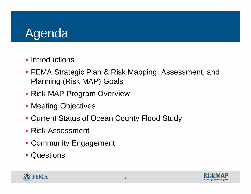
Agenda
IntroductionsFEMA Strategic Plan & Risk Mapping, Assessment, and Planning (Risk MAP) GoalsRisk MAP Program OverviewMeeting ObjectivesCurrent Status of Ocean County Flood StudyRisk AssessmentCommunity EngagementQuestions

3
IntroductionsLocal – Ocean County (Host) & CommunitiesState – New Jersey Department of Environmental Protection (NJDEP)Supervising Engineer: Joseph Ruggeri, PE, CFMSupervising Engineer: John ScordatoProgram Development Specialist: Jim WattSenior Engineer: Kunal Patal
FEMA Region IIMitigation Division Director: Timothy P. CrowleyCommunications / Outreach Lead: William McDonnell Study Project Manager: Paul K. Weberg, PE Floodplain Management and Insurance Lead: Pat GriggsRegional Program Management Lead: Bo Juza, CFM Regional Support Center Coordinator: Andrew Martin, CFMRegional Support Center Outreach Lead: Crystal Smith, CFM

4
FEMA Strategic Plan & Risk MAP GoalsFEMA Strategic Plan Goals 2008-2013
o Lead an integrated approach that strengthens the Nation’s ability to address disasters, emergencies, and terrorist events
o Deliver easily accessible and coordinated assistance for all programso Provide reliable information at the right time for all userso FEMA invests in people and people invest in FEMA to ensure mission
successo Build public trust and confidence through performance and stewardship
FEMA Risk MAP GoalsCollaboration with Federal, State and local stakeholders to achieve goals under Risk MAP:
o Address gaps in flood hazard datao Public Awareness/Outreacho Hazard Mitigation Planningo Enhanced Digital Platformo Alignment and Synergies

5
Guiding PrinciplesEngage communities early and oftenAgree upon and document project outcomes and responsibilitiesCoordinate with other programs operating within the same communityLeverage associations to provide a third-party perspectiveUse local media and language that people understand

6
Risk MAP Program Overview
7
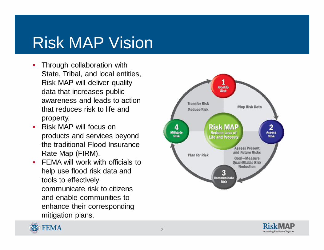
Risk MAP VisionThrough collaboration with State, Tribal, and local entities, Risk MAP will deliver quality data that increases public awareness and leads to action that reduces risk to life and property. Risk MAP will focus on products and services beyond the traditional Flood Insurance Rate Map (FIRM). FEMA will work with officials to help use flood risk data and tools to effectively communicate risk to citizens and enable communities to enhance their corresponding mitigation plans.

8
FEMA’s FY10 Flood Mapping Progress Report and Production Plan
With FY 2009 and FY2010 Congressional appropriations for Flood Hazard Mapping, FEMA is conducting flood map update projects:• Address gaps in required engineering and mapping for
high flood risk areas affected by coastal flooding, levees, and other riverine flood hazards
• Leverage established Cooperating Technical Partner (CTP) relationships
To learn more, see the FEMA’s FY10 Flood Mapping Progress Report and Production Plan on www.fema.gov

9
Recent ActivitiesInitial meetings conducted: ◦ Morris: April, 2010◦ Bergen: June, 2010 & June, 2011◦ Somerset: June, 2010◦ Essex: July, 2010◦ Monmouth: August, 2010◦ Union: August, 2010◦ Cape May: September, 2010◦ Passaic: October, 2010◦ Middlesex: October, 2010◦ Atlantic: November, 2010◦ Ocean: December, 2010◦ Cumberland: February, 2011 & June, 2011◦ Salem: February, 2011
10
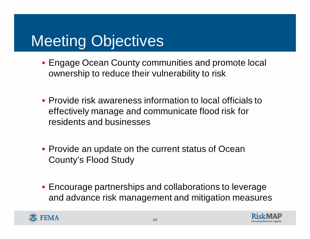
Meeting ObjectivesEngage Ocean County communities and promote local ownership to reduce their vulnerability to risk
Provide risk awareness information to local officials to effectively manage and communicate flood risk for residents and businesses
Provide an update on the current status of Ocean County’s Flood Study
Encourage partnerships and collaborations to leverage and advance risk management and mitigation measures

11
Coastal and riverine analysis to be completed by July 2012
Project Team• Local Officials• New Jersey Department of Environmental Protection
(Cooperating Technical Partner)• FEMA
Risk Assessment, Mapping, and Planning Partners (RAMPP), a joint venture of Dewberry, URS, and ESPRegional Program Management LeadRegional Support Center
Ocean County Flood Study -Overview
12
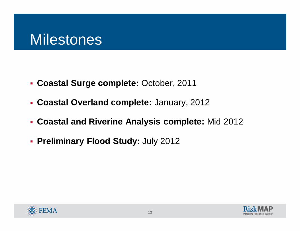
Milestones
Coastal Surge complete: October, 2011
Coastal Overland complete: January, 2012
Coastal and Riverine Analysis complete: Mid 2012
Preliminary Flood Study: July 2012

13
Ocean County Flood Study -Scope
Incorporation of 10.8 miles of new detailed riverine and 64.6 miles of approximate riverine analysis
Restudy of all coastal hazard zones - 45 shoreline miles of detailed coastal analysis
Incorporation of NJFHA boundary (1.25% flood) for detailed riverine analysis to the Flood Insurance Study Report (FIS) profiles and Flood Insurance Rate Maps (FIRM)
14
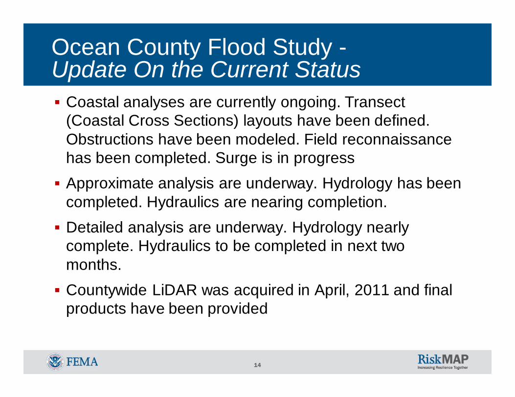
Coastal analyses are currently ongoing. Transect (Coastal Cross Sections) layouts have been defined. Obstructions have been modeled. Field reconnaissance has been completed. Surge is in progressApproximate analysis are underway. Hydrology has been completed. Hydraulics are nearing completion.Detailed analysis are underway. Hydrology nearly complete. Hydraulics to be completed in next two months.Countywide LiDAR was acquired in April, 2011 and final products have been provided
Ocean County Flood Study -Update On the Current Status

15
Ocean County –New Detailed Studies
FLOODING SOURCE Reach Upstream Limit Downstream Limit
North Branch Forked River 4.4 At Garden State Parkway At confluence with Barnegat Bay
Cedar Creek 6.4 At Garden State Parkway At confluence with Barnegat Bay
TOTAL MILEAGE 10.8
16
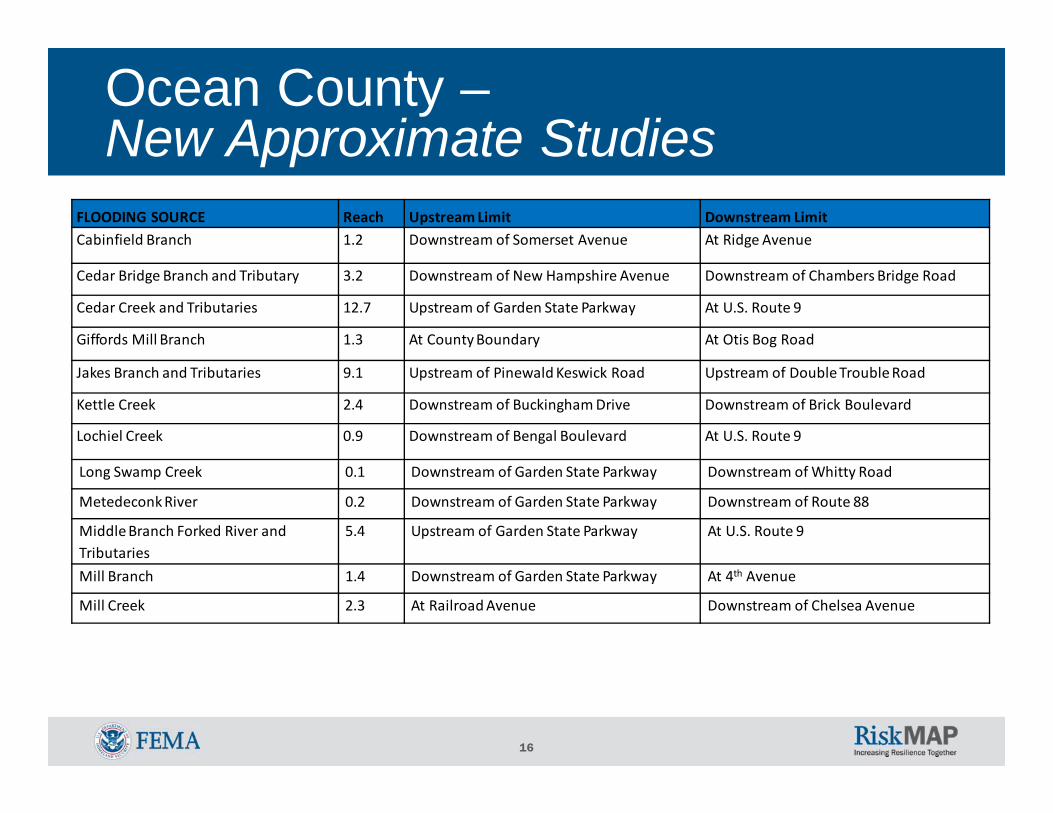
Ocean County –New Approximate Studies
FLOODING SOURCE Reach Upstream Limit Downstream LimitCabinfield Branch 1.2 Downstream of Somerset Avenue At Ridge Avenue
Cedar Bridge Branch and Tributary 3.2 Downstream of New Hampshire Avenue Downstream of Chambers Bridge Road
Cedar Creek and Tributaries 12.7 Upstream of Garden State Parkway At U.S. Route 9
Giffords Mill Branch 1.3 At County Boundary At Otis Bog Road
Jakes Branch and Tributaries 9.1 Upstream of PinewaldKeswick Road Upstream of Double Trouble Road
Kettle Creek 2.4 Downstream of Buckingham Drive Downstream of Brick Boulevard
Lochiel Creek 0.9 Downstream of Bengal Boulevard At U.S. Route 9
Long Swamp Creek 0.1 Downstream of Garden State Parkway Downstream of Whitty Road
MetedeconkRiver 0.2 Downstream of Garden State Parkway Downstream of Route 88
Middle Branch Forked River and Tributaries
5.4 Upstream of Garden State Parkway At U.S. Route 9
Mill Branch 1.4 Downstream of Garden State Parkway At 4th Avenue
Mill Creek 2.3 At Railroad Avenue Downstream of Chelsea Avenue
17
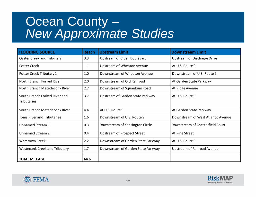
Ocean County –New Approximate Studies
FLOODING SOURCE Reach Upstream Limit Downstream LimitOyster Creek and Tributary 3.3 Upstream of Cluen Boulevard Upstream of Discharge Drive
Potter Creek 1.1 Upstream of WheatonAvenue At U.S. Route 9
Potter Creek Tributary 1 1.0 Downstream of Wheaton Avenue Downstream of U.S. Route 9
North Branch Forked River 2.0 Downstream of Old Railroad At Garden State Parkway
North Branch MetedeconkRiver 2.7 Downstream of SquankumRoad At Ridge Avenue
South Branch Forked River and Tributaries
3.7 Upstream of Garden State Parkway At U.S. Route 9
South Branch Metedeconk River 4.4 At U.S. Route 9 At Garden State Parkway
Toms River and Tributaries 1.6 Downstream of U.S. Route 9 Downstream of West Atlantic Avenue
Unnamed Stream 1 0.3 Downstream of Kensington Circle Downstream of Chesterfield Court
Unnamed Stream 2 0.4 Upstream of Prospect Street At Pine Street
Waretown Creek 2.2 Downstream of Garden State Parkway At U.S. Route 9
Westecunk Creek and Tributary 1.7 Downstream of Garden State Parkway Upstream of Railroad Avenue
TOTAL MILEAGE 64.6

18
Ocean County Flood Study -Affected Panels

19
Local technical data availability?Bridge replacements; new storm water management systems; new H&H studies; new aerial photography and/or topographic information, etc.
Contacted each community letting them know about coastal field reconnaissance and field survey taking place in their communities in November 24, 2009, and data request in January 21, 2010
Received response only from Town of Stafford and Borough of Beach Haven
Levee impacted areas?As part of its effort to reform NFIP, FEMA is exploring more precise approaches for identifying flood hazards in areas impacted by levees
FEMA is replacing the approach currently used and developing alternative ways to analyze and map the flood hazards in areas impacted by levees
Local Communities –Data Gathering

20
Coastal Storm Surge and Overland Wave Hazard Analysis Overview – Gulf & Atlantic
6. Mapping
5. RUNUP
4. WAVES
3. EROSION
2. SETUP
1. SURGE
21
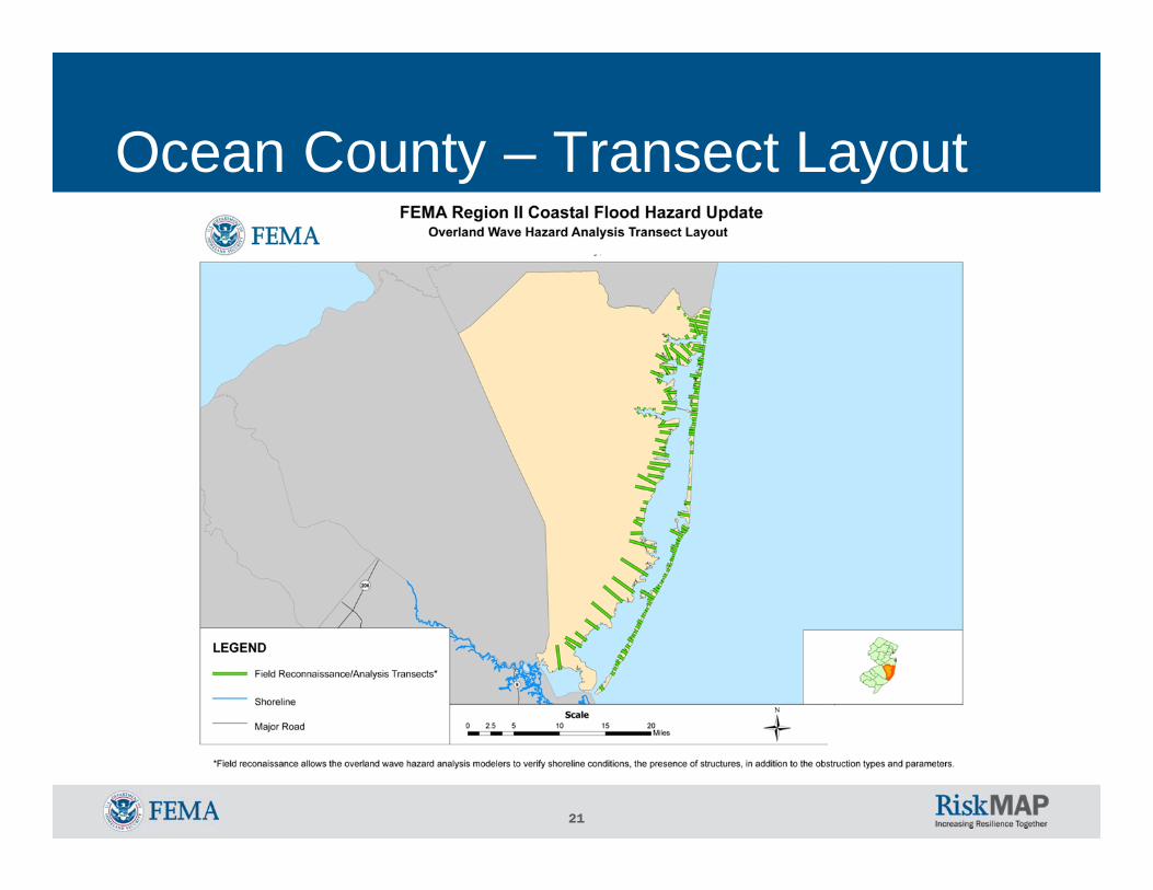
Ocean County – Transect Layout

22
The intent of the technical panel is to engage subject matter experts in coastal engineering analysis process
Meetings were held on:4/14/20115/10/2011
Members:Academics and Other Interested Parties:
Stevens Institute of TechnologyRichard Stockton College of NJCity University of New York – Hunter CollegeCousteau Institute under Rutgers UniversityColumbia UniversityBarnegat Bay Partnership
State and Local Government:New Jersey Department of Environmental ProtectionNew York State Department of Environmental ConservationNew York CityNortheast States Emergency Consortium
Other Federal Agencies:USACENOAAUSGS
Coastal Study Technical Panel
23
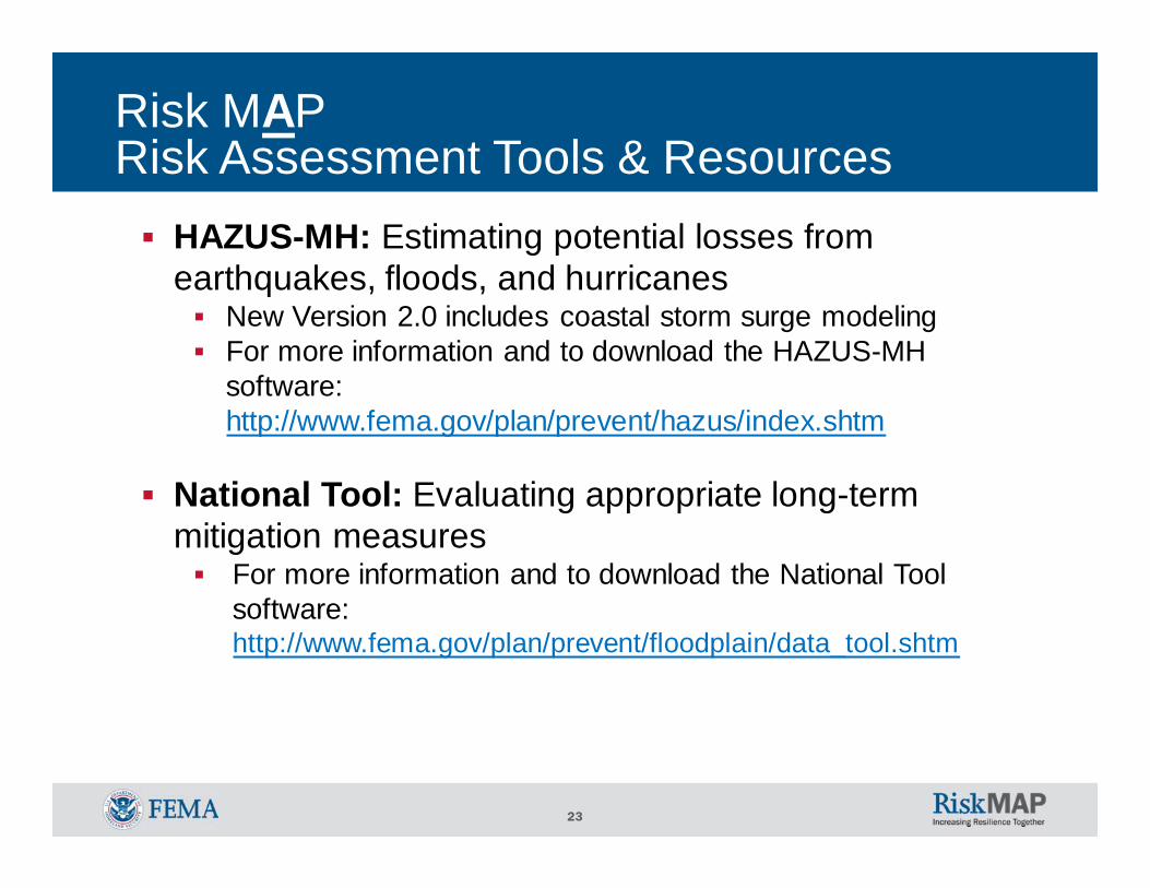
Risk MAPRisk Assessment Tools & Resources
HAZUS-MH: Estimating potential losses from earthquakes, floods, and hurricanes
New Version 2.0 includes coastal storm surge modelingFor more information and to download the HAZUS-MH software: http://www.fema.gov/plan/prevent/hazus/index.shtm
National Tool: Evaluating appropriate long-term mitigation measures
For more information and to download the National Tool software: http://www.fema.gov/plan/prevent/floodplain/data_tool.shtm

24
Ocean County – NFIP Policies, Claims, Repetitive Losses, CRS, CAC & CAV
COMMUNITY Number of Policies
Total Coverage Total Premium
Total Claims Since 1978
Total Paid Since 1978
Number of Repetitive Losses
CRS
CommunityAssistance Contact (CAC)
CommunityAssistance
Visit (CAV)
Borough of Barnegat Light 1,034 $279,170,900 $863,346 64 $309,905 2 YES 2006 1993
Borough of Bay Head 617 $175,174,700 $865,046 200 $1,049,258 24 YES 8/2010 2008
Borough of Beach Haven 2,471 $618,151,500 $2,580,995 949 $8,021,451 152 YES 2007 2007Borough of Beachwood 49 $13,394,100 $32,091 5 $39,786 0 2006 ‐
Borough of Harvey Cedars 1,078 $306,966,800 $985,637 244 $1,318,461 12 YES 3/2011 1992Borough of Island Heights 95 $24,113,300 $54,136 15 $98,313 4 2006 ‐
Borough of Lavallette 2,003 $451,593,000 $1,873,736 283 $1,216,452 16 YES 2/2011 2010
Borough of Mantoloking 502 $153,030,400 $754,745 136 $1,291,319 6 YES 2007 2007
Borough of Ocean Gate 398 $80,694,500 $377,461 85 $445,877 14 2006 1992
Borough of Pine Beach 28 $8,830,800 $15,553 4 $2,244 0 2006 1992
Borough of Point Pleasant 1,696 $420,857,900 $1,425,509 162 $686,371 0 YES 2009 1991Borough of Point Pleasant Beach 1,705 $406,744,300 $2,286,537 488 $3,932,526 61 YES 5/2011 2006
Borough of Seaside Heights 1,417 $234,443,500 $1,277,375 174 $1,199,755 35 6/2010 1991
Borough of Seaside Park 1,390 $301,666,700 $1,420,276 183 $1,142,979 46 YES 8/2010 2005
Borough of Ship Bottom 1,608 $401,512,000 $1,514,015 478 $4,280,709 70 YES 2006 2002

25
Ocean County – NFIP Policies, Claims, Repetitive Losses, CRS, CAC & CAV
COMMUNITY Number of Policies
Total Coverage Total Premium
Total Claims Since 1978
Total Paid Since 1978
Number of Repetitive Losses
CRS
CommunityAssistance Contact (CAC)
CommunityAssistance
Visit (CAV)
Borough of South Toms River 36 $7,094,400 $40,403 21 $141,390 7 ‐ 1992
Borough of Surf City 1,715 $456,155,300 $1,757,178 377 $1,460,221 27 YES 2006 2008
Borough of Tuckerton 612 $132,409,100 $527,509 729 $5,118,659 157 YES 2009 2000Township of Barnegat 516 $130,319,200 $374,781 109 $490,536 20 YES 2007 2001
Township of Berkeley 2,270 $537,386,500 $1,558,202 344 $2,602,248 70 YES 2009 2006Township of Brick 3,741 $975,576,900 $3,570,590 593 $3,204,282 40 12/2010 2009
Township of Eagleswood 102 $23,497,900 $78,351 100 $707,358 38 2006 2000
Township of Lacey 2,895 $710,400,300 $2,268,183 524 $4,136,516 191 YES 5/2010 2007
Township of Lakewood 153 $35,117,500 $83,979 12 $55,617 2 2006 ‐
Township of Little Egg Harbor 3,092 $627,224,900 $3,082,159 1,497 $16,336,290 351 2009 2008
Township of Long Beach 7,295 $2,005,609,200 $7,132,746 2,078 $12,898,571 187 YES 5/2010 2007
Township of Ocean 1,045 $252,732,700 $901,567 273 $1,937,940 33 YES 11/2010 1992
Township of Stafford 3,644 $876,658,900 $3,004,427 1,399 $10,163,405 196 YES 2008 6/2011
Township of Toms River 8,630 $1,887,022,600 $8,078,559 1,741 $11,545,412 290 YES 5/2011 2008
County Total 52,107 $12,601,303,100 $48,989,000 13,317 $95,964,348

26
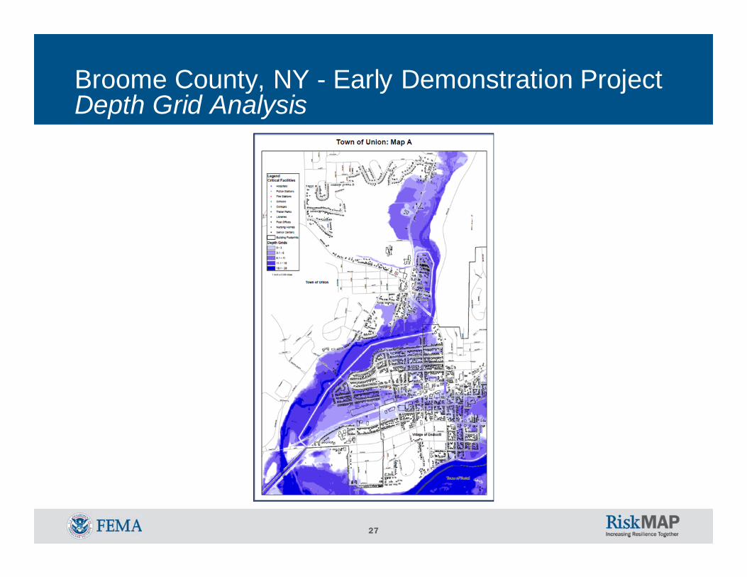
Broome County, NY - Early Demonstration ProjectDepth Grid and HAZUS-MH Development / Area of Mitigation Interest
FEMA Region II developed potential demonstration projects to field test proposed Risk MAP productsWhy in Broome?
o New Hydrology indicated an upward trend in flood discharge
o Increased flow created potential issues due to levee de-accreditation
27
Broome County, NY - Early Demonstration ProjectDepth Grid Analysis

28
Broome County, NY - Early Demonstration Project Example Area of Mitigation Interest
Robinson St. was initially identified as the sole source for flooding of a large area
The area was of interest to the City of Binghamton as a potential economic development site

29
Risk MAPMitigation Planning
Hazard Mitigation Plans:• Guides your decisions on mitigation activities for all hazards you
face• Are an important resource responsible for responding to disasters• Facilitates fast access to federal assistance for mitigation
Ocean County Mitigation Plans: • Funded, but no submittals yet

30
Ocean County, NJ Mitigation Plan Update
31
Hazard Mitigation Assistance (HMA)
HMA grant programs provide funding for eligible mitigation activities that reduce disaster losses and protect life and property from future disaster damages
Communities with approved hazard mitigation plans can apply for Federal Assistance on declared/non-declared disasters
Federal Assistance applications through New Jersey OEM (Bob Little)

32
Community Rating System (CRS)The National Flood Insurance Program's (NFIP) Community Rating System (CRS) is a voluntary incentive program that recognizes and encourages community floodplain management activities that exceed the minimum NFIP requirements
As a result, flood insurance premium rates are discounted to reflect the reduced flood risk resulting from the community actions meeting the three goals of the CRS:• Reduce flood losses;• Facilitate accurate insurance rating; and• Promote the awareness of flood insurance
33
Risk CommunicationsFederal/State/Local goals:• To aid in safer communities and reduce risk to life and
property• To effectively communicate risk and increase public
awareness, leading citizens to make informed decisions regarding their risk
Key factors contributing to successful achievement of these goals are: • Community engagement and exchange of flood risk
information• Effective collaboration through partnerships• Strategic communications plan development

34
Risk CommunicationsAcknowledgement of the challenges in complex, multi-disciplinary, multi-dimensional, and evolving processes of risk communications• Conflicting priorities and messages• Difficulty in translating scientific information• Disagreements on what is risk
FEMA created a list of supporting, customizable tools and templates and is currently developing those materials in order of need as identified by FEMA Regions• Region II is waiting on FEMA HQ’s development and
outcomes• Region II is initiating it’s own risk communications strategy
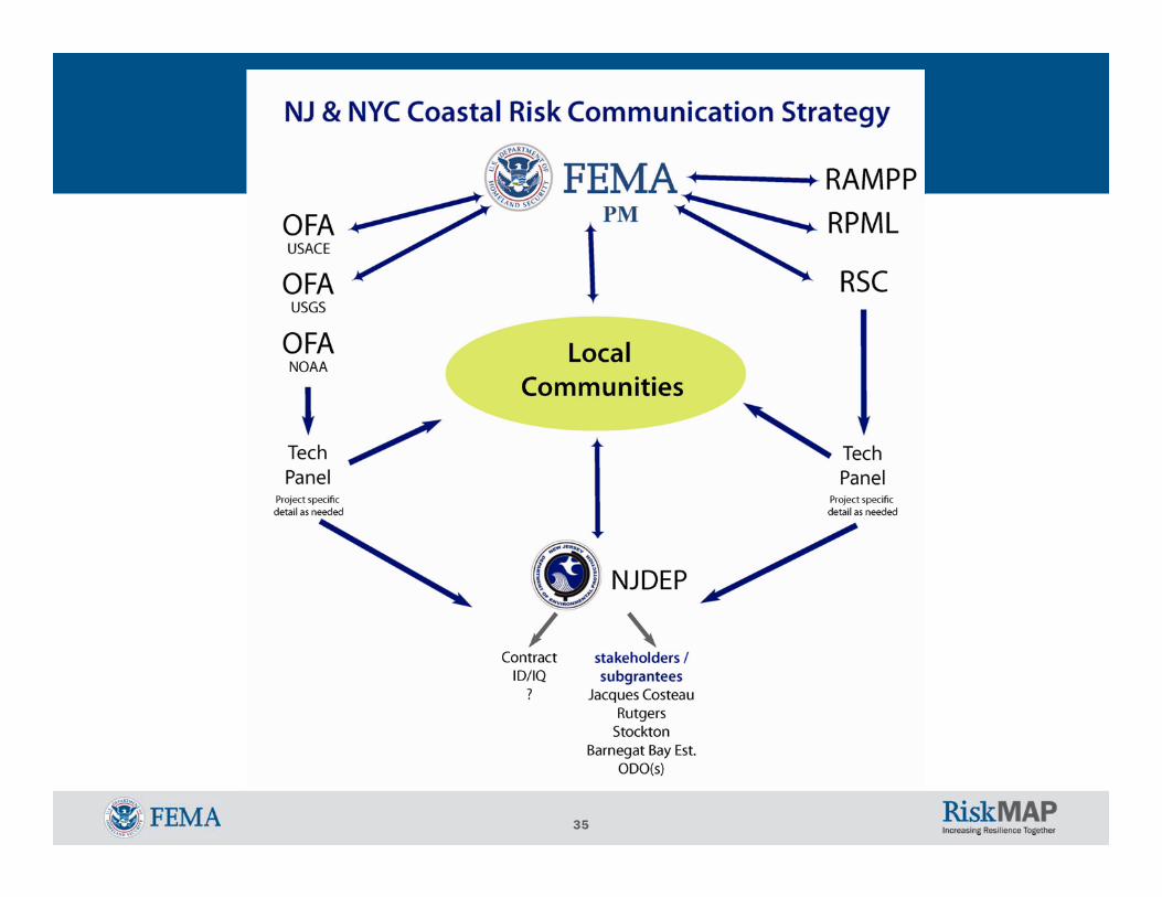
35
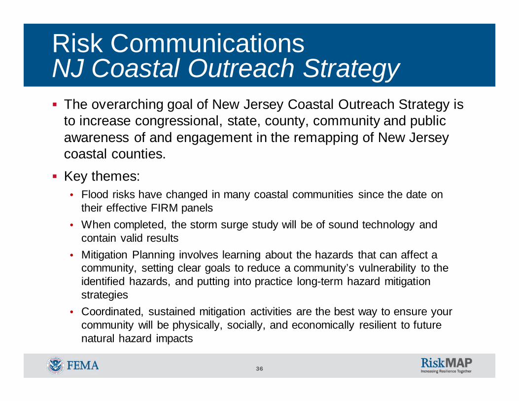
36
The overarching goal of New Jersey Coastal Outreach Strategy is to increase congressional, state, county, community and public awareness of and engagement in the remapping of New Jersey coastal counties. Key themes:
• Flood risks have changed in many coastal communities since the date on their effective FIRM panels
• When completed, the storm surge study will be of sound technology and contain valid results
• Mitigation Planning involves learning about the hazards that can affect a community, setting clear goals to reduce a community’s vulnerability to the identified hazards, and putting into practice long-term hazard mitigation strategies
• Coordinated, sustained mitigation activities are the best way to ensure your community will be physically, socially, and economically resilient to future natural hazard impacts
Risk CommunicationsNJ Coastal Outreach Strategy
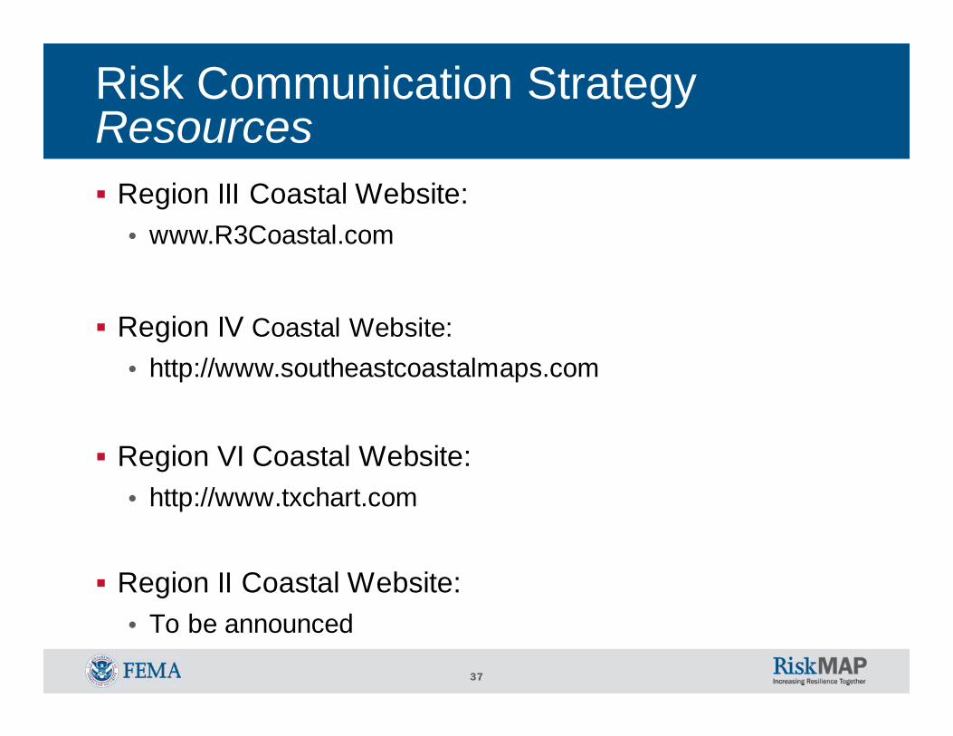
37
Risk Communication StrategyResources
Region III Coastal Website:• www.R3Coastal.com
Region IV Coastal Website:• http://www.southeastcoastalmaps.com
Region VI Coastal Website:• http://www.txchart.com
Region II Coastal Website:• To be announced

38
Example FEMA Region IIRisk MAP Activities Schedule
Current: July, 2011• Risk MAP overview and introduction
September, 2011• Risk communications strategy update
November, 2011• Risk assessment training
January, 2012• Mitigation planning training
March, 2012• Risk communications review and support
May, 2012• Risk assessment review and support
July, 2012• Mitigation planning review and support

39
Resources
FEMA: www.fema.govFloodsmart, the official site of the National Flood Insurance Program (NFIP): www.floodsmart.govRisk Assessment, Mapping and Planning Partners: www.RAMPP-team.comNFIP Reform: www.fema.gov/business/nfip/nfip_reform.shtm HAZUS-MH software: http://www.fema.gov/plan/prevent/hazus/index.shtmNational Tool software: http://www.fema.gov/plan/prevent/floodplain/data_tool.shtmHazus User Groups: http://www.fema.gov/plan/prevent/hazus/hz_users.shtm#4
New Jersey Department of Environmental Protection - NFIP CoordinatorNew Jersey State Office of Emergency Management

40
Questions & FeedbackPlease complete your survey. Your feedback is very important to us.This presentation & hand-outs will be posted at: www.RAMPP-TEAM.com
Contact InformationNJDEPJoseph Ruggeri / John Scordato / Chris Gould NJDEP, Bureau of Dam Safety & Flood ControlPhone: 609-292-2296NJDEP website: www.nj.gov/dep/floodcontrol
FEMAMitigation Division Director: Timothy P. Crowley / 212-680-3627/ [email protected] Analysis Branch Chief: Scott Duell / 212-680-3630 / [email protected] and Outreach: William McDonnell / 212-680-3636 / [email protected] Project Manager: Paul Weberg / 212-680-3638 / [email protected] Insurance & Management: Pat Griggs / 212-680-8523 / [email protected] Planning: Cathleen Carlisle / 212-680-8529 / [email protected] & GIS: Brian Shumon / 212-680-3631 / [email protected] Support Center Coordinator: Andrew Martin / 646-216-3677 / [email protected] Project Management Lead: Bo Juza / 646-801-6460 / [email protected]