Flood Risk Assessment (Black & Veatch) · 2016-04-20 · BLACK & VEATCH ABLE UK LTD 1 1...
30
Annex 36.1 Flood Risk Assessment (Black & Veatch)
Transcript of Flood Risk Assessment (Black & Veatch) · 2016-04-20 · BLACK & VEATCH ABLE UK LTD 1 1...

Annex 36.1
Flood Risk Assessment
(Black & Veatch)


Compensation Site
Flood Risk Assessment Annex 36.1
November 2011

Document Issue Details:
BVL project no. 121726 Client’s ref. no. n/a
Version no. Issue date Issue status Distribution
1.0 28 April 2011 Draft for review Able and consultees
1.2 6 May 2011 Draft for issue Able and Environment Agency
2 23 June 2011 Draft final Able and consultees
3 17th Sept 2011 Final Able and consultees
Final 22nd
Nov 2011 Final Environmental Statement
Quality Assurance Record:
Version no. Issue status Author Checker Reviewer
1.0 Draft P La Roche N Scott D C Keiller
1.2 Draft DC Keiller V Lutyens V Lutyens
2 Draft final DC Keiller V Lutyens V Lutyens
3 Final DC Keiller V Lutyens V Lutyens
Final Final DC Keiller N Meakins N Meakins
Notice:
This report was prepared by Black & Veatch Limited (BVL) solely for use by Able UK Ltd. This
report is not addressed to and may not be relied upon by any person or entity other than Able. for any
purpose without the prior written permission of BVL. BVL, its directors, employees and affiliated
companies accept no responsibility or liability for reliance upon or use of this report (whether or not
permitted) other than by Able for the purposes for which it was originally commissioned and
prepared.
In producing this report, BVL has relied upon information provided by others. The completeness or
accuracy of this information is not guaranteed by BVL.

BLACK & VEATCH ABLE UK LTD
I
CONTENTS
1 INTRODUCTION 1
1.1 FORMAT OF FLOOD RISK ASSESSMENT 1
1.2 BACKGROUND TO THE FLOOD RISK ASSESSMENT 1
1.3 NEED FOR THE DEVELOPMENT AND BENEFITS PROVIDED 2
2 FLOOD RISK ASSESSMENT 8
2.1 INFORMATION ON THE DEVELOPMENT 8
2.2 CURRENT AND FUTURE FLOOD HAZARD AND PROBABILITY 11
2.3 APPLICABILITY OF THE SEQUENTIAL AND EXCEPTION TESTS 15
2.4 RESIDUAL FLOOD RISK AND FUTURE FLOOD RISK MANAGEMENT 16
3 CONCLUSIONS 23
4 BIBLIOGRPAHY 24
FIGURES
Figure 1 Location of the proposed Compensation Site. .................................. 1
Figure 2 Existing site layout at Cherry Cobb Sands ........................................ 4
Figure 3 Future site layout at Cherry Cobb Sands ........................................... 5
Figure 4 Location and existing site layout at Old Little Humber Farm ....... 6
Figure 5 Future site layout at Old Little Humber Farm .................................. 7
Figure 6 Current flood zone mapping at Cherry Cobb Sands from ERYC SFRA
................................................................................................................ 21
Figure 7 Flood zone mapping at Cherry Cobb Sands with realigned defence 22
TABLES
Table 1 Numbers of properties in flood hazard zones ..................................... 19
Table 2 Flood risk to people behind defences (from FD2320) ......................... 19
Table 3 Number of properties in each Flood Risk to People category ........... 20

BLACK & VEATCH ABLE UK LTD
II
This page is intentionally left blank

BLACK & VEATCH ABLE UK LTD
1
1 INTRODUCTION
1.1 FORMAT OF FLOOD RISK ASSESSMENT
1.1.1 This report details the Flood Risk Assessment (FRA) that has been
undertaken for Able‟s proposed Compensation Site on the north bank of the
Humber. The Compensation Site comprises managed realignment works at
Cherry Cobb Sands and the provision of wet grassland at Old Little Humber
Farm until the managed realignment has had time to fully develop the
required functional habitat.
1.1.2 This FRA has been completed in accordance with PPS25. The proposed
Compensation Site is located on the north bank of the Humber Estuary
(central OS grid references TA 224 209 and TA 205 242) (Figure 1) in the area
covered by the East Riding of Yorkshire Strategic Flood Risk Assessment
(SFRA) (ERYC, 2010). The FRA process is detailed in Section 2 of this report
and conclusions presented in Section 3.
Figure 1 Location of the proposed Compensation Site.
1.2 BACKGROUND TO THE FLOOD RISK ASSESSMENT
1.2.1 The purpose of the Compensation Site is to create compensatory habitat for
losses that will be caused by development of the Able Marine Energy Park

BLACK & VEATCH ABLE UK LTD
2
(AMEP). The major requirement is to create a managed realignment site at
Cherry Cobb Sands that will compensate for loss of SAC estuary features and
also provide fully functioning habitat for SPA and Ramsar wading birds and
wildfowl. As fully functioning habitat takes some time to develop in a
managed realignment site, the short term provision of wet grassland at Old
Little Humber farm is also proposed.
1.2.2 The works at Cherry Cobb Sands involve realigning the existing tidal flood
defences further inland. Areas that are currently protected from flooding
will be allowed to flood in order to create wildlife habitat. The project will
also provide a better standard of flood protection than the existing tidal
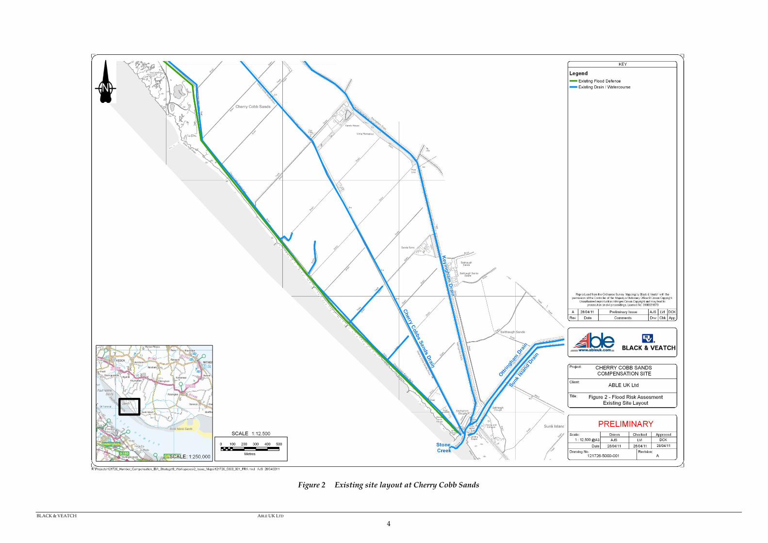
defences. The existing site layout at Cherry Cobb Sands is shown on Figure 2.
The proposed future site layout is shown on Figure 3.
1.2.3 The works at Old Little Humber Farm involve re-profiling the land surface
by creating shallow ridges surrounding shallow furrows and stopping the
existing land drains within the site so that drainage into the surrounding
ditches is impeded. The works will not interfere with any of the existing
drainage ditches. The existing site layout at Old Little Humber Farm site is
shown on Figure 4, whilst the proposed layout is shown in Figure 5.
1.3 NEED FOR THE DEVELOPMENT AND BENEFITS PROVIDED
1.3.1 The need for the AMEP development and the benefits it will provide are
described in Chapters 4 and 5 of the Environmental Statement.
1.3.2 AMEP is located on the south bank of the Humber Estuary, which is
protected under both national and European law, including the EC Habitats
Directive (92/43/EEC). As the proposals for that site will, if consented,
cause the loss of a significant area of inter-tidal mudflat and of sub-tidal
habitat, and those habitats are protected under the Directive, it is necessary
to provide compensatory habitat to ensure the continued coherence of the
Natura 2000 network. Accordingly, a habitat creation site on the north bank
has been proposed to provide new inter-tidal habitat and provide functional
value for those species for which the area has been designated.
1.3.3 The development of AMEP on the south bank of the Humber will lead to the
direct and indirect loss of up to 51.5 ha of internationally designated Humber
Estuary SAC, SPA and Ramsar sites.
1.3.4 To provide compensation for these losses it is proposed to develop a site on
the north bank of the Humber at Cherry Cobb Sands, which would
incorporate 100 ha of new intertidal habitat. In addition 38 ha of wet

BLACK & VEATCH ABLE UK LTD
3
grassland will be provided at Old Little Humber Farm until the habitat at the
managed realignment site becomes fully functional.
BLACK & VEATCH ABLE UK LTD
4
Figure 2 Existing site layout at Cherry Cobb Sands

BLACK & VEATCH ABLE UK LTD
5
Figure 3 Future site layout at Cherry Cobb Sands

BLACK & VEATCH ABLE UK LTD
6
Figure 4 Location and existing site layout at Old Little Humber Farm

BLACK & VEATCH ABLE UK LTD
7
Figure 5 Future site layout at Old Little Humber Farm

BLACK & VEATCH ABLE UK LTD
8
2 FLOOD RISK ASSESSMENT
2.1 INFORMATION ON THE DEVELOPMENT
Description of the Development
Cherry Cobb Sands
2.1.1 Cherry Cobb Sands lies on the north bank of the Humber Estuary,
approximately 5 km south-west of the village of Keyingham and 15 km
south-east of the city of Hull. The site will be located between the Humber
Estuary and Cherry Cobb Sands Road, which provides access to the
properties and radar mast near the drainage sluices at Stone Creek. The site
is agricultural land at present and is owned by the Crown Estate.
2.1.2 It is proposed that a new set-back tidal flood defence embankment be
constructed from material within the site and then the existing embankment
will be breached to create an intertidal area that will compensate for the loss
of 51.5 ha of the Humber Estuary SAC, SPA and Ramsar sites. Within the
intertidal area, ground levels will be re-contoured to provide new habitat of
functional value to wildfowl and wading birds as well as other flora and
fauna.
2.1.3 Cherry Cobb Sands Road and Cherry Cobb Sands Drain will remain on the
defended side of the tidal embankment. The managed realignment area will
comprise intertidal habitat and, hence, will be water compatible
development.
2.1.4 The defended area outside of the site currently comprises the Humber tidal
floodplain and the works will not change this. The Humber tidal floodplain
area will contain all five vulnerability classifications, including essential
infrastructure.
2.1.5 The layout of the scheme is shown in Figure 3. The proposed new flood
defence will tie into the existing flood defence at either end and will include
the diverted PROW that currently runs along the embankment crest. The
embankment will be defended against wave erosion along its seaward face.
2.1.6 A soke dyke will be provided adjacent to the landward toe of the
embankment which will collect any seepage through the embankment. This
soke dyke will connect into the existing soke dyke at the southern end of the
site.

BLACK & VEATCH ABLE UK LTD
9
Old Little Humber Farm
2.1.7 The existing arable fields at Old Little Humber Farm will be re-profiled to
provide a ridge and furrow landscape to support wet grassland habitat. The
soil within the site will be scraped from furrows and formed into
surrounding ridges. The surrounding ridges will be kept 10 m clear of the
drains that mark the field edges. Ridges will be approximately 0.25m higher
than the existing land surface while furrows will be approximately 0.25 m
lower.
Drainage of the Existing Site
Cherry Cobb Sands
2.1.8 Drainage of the Cherry Cobb Sands site is currently via a network of lateral
land drains that run in a generally northwest / southeast orientation across
the fields. These connect to „header‟ land drains that flow northeast to
Cherry Cobb Sands Drain (running along the southern shoulder of Cherry
Cobb Sands Road). Cherry Cobb Sands Drain discharges into the Humber
Estuary at Stone Creek through a sluice structure. Discharge becomes tide-
locked during high tides and the configuration of the sluice prevents sea
water flowing into the Drain.
2.1.9 Immediately landward of the existing flood defence, there is a soke dyke. It
is understood that a small percentage of some of the header land drains may
connect to this dyke. The dyke runs southeast, out of the site and past the
radar mast, before turning northwards and connecting in to Cherry Cobb
Sands Drain, just prior to it discharging into Stone Creek.
2.1.10 Cherry Cobb Sands Drain runs from Little Humber, approximately 2 km
northwest of the site. This watercourse drains all land to the west of
Keyingham Drain. Land to the north of Little Humber is thought to drain
into the Thorngumbald Internal Drainage Board (IDB) catchment.
Old Little Humber Farm
2.1.11 Old Little Humber Farm is currently drained by a series of lateral and header
land drains that discharge into drainage ditches on the field boundaries that
feed into South Ends and Thorney Crofts Drain in the Thorngumbald IDB.

BLACK & VEATCH ABLE UK LTD
10
Compliance of Development with other Studies and Local Development
Documents
2.1.12 At present, the whole Compensation Site is covered by the Joint Structure
Plan for Kingston Upon Hull and the East Riding Of Yorkshire (Hull City
Council & East Riding of Yorkshire Council, 2005) and the Holderness
District Wide Local Plan (1999).
2.1.13 Policy NAT6 from the Joint Structure Plan for Kingston Upon Hull and the East
Riding Of Yorkshire states that:
‘Development in coastal areas should in general, be focused on existing settlements
in accordance with the development strategy. Any new development proposed at an
undeveloped coastal location, or roll back of existing development, should avoid:
(i) the risk from flooding, erosion and landslip, within the lifetime of a building;
(ii) areas subject to managed realignment or monitor/review of coastal defence
management measures;
(iii) a requirement to construct new or to extend or enhance existing coastal
protection or flood defences;
(iv) significant interference with natural coastal or estuarine processes; and
(v) increasing the risk of flooding and coastal erosion, or affecting accretion and
deposition of eroded materials on sites elsewhere.’
2.1.14 Policy Env7 of the Holderness District Wide Local Plan which states that:
‘The Council will allow development in accordance with policy Env5 and the
relevant policies applying to the specific location. Development will be required to
maintain or improve the attractiveness of the local environment and complement the
character of the area. Development will not be allowed to extend laterally along the
cliff top outside existing coast defences’.
2.1.15 Policy Env5 of the Holderness District Wide Local Plan which states that:
‘The Council will only approve development proposals in the Holderness coastal zone
which are not likely during the life expectancy of the development to:
i) lead to a requirement to construct new or to extend or enhance existing coastal
protection or flood defences
ii) interfere significantly with natural coastal or estuarine processes
iii) increase the risk of flooding and coastal erosion on site or elsewhere

BLACK & VEATCH ABLE UK LTD
11
iv) be affected by the risk of coastal erosion within the developments estimated
lifespan
v) conflict with nature conservation policies of this plan.
vi) preclude reasonably practical options to conserve or enhance important coastal
habitats by managed retreat or soft engineering techniques’.
2.1.16 In September 2004, the Planning and Compulsory Purchase Act 2004 brought
in major changes to the development plan system. The old system of
Structure Plans, Local Plans and Supplementary Planning Guidance is being
replaced with Regional Spatial Strategies (RSSs) and Local Development
Frameworks (LDFs).
2.1.17 The draft Core Strategy of the East Riding Local Development Framework
(LDF), which sets out the spatial vision and key strategic policies for growth
and development of the District up to 2026, was consulted on in 2010. A
further round of consultation will end on 19th December 2011.
2.1.18 The Environment Agency recently published the Humber Flood Risk
Management Strategy (Environment Agency, 2008). The Agency has
identified that defences between Stone Creek and Paull Holme Strays are in
good condition and no major works are planned for 40 years, though the
Environment Agency conclude that „in the long term those responsible [for the
defences] may decide it is not worthwhile carrying on.‟ The Environment Agency
„cannot say when this might happen, although [they] think it is unlikely within the
next 20 years’.
2.1.19 Within the Management Strategy, the Cherry Cobb Sands managed
realignment site as illustrated on Figure 4.2 (op. cit. pp29) has been identified
as a „Planned habitat creation site‟ where realignment of estuary defences is
proposed after 2030 (op. cit. pp 17) to meet obligations under the Habitats
Directive to replace losses caused by the strategy (Humber CHaMP), and to
maintain the site in favourable condition. The use of this site for
Compensation as described in this proposal will have implications for the
Environment Agency in the delivery of the habitat creation component of its
Flood Risk Management Strategy.
2.2 CURRENT AND FUTURE FLOOD HAZARD AND PROBABILITY
2.2.1 The following section provides information on flooding mechanisms that
could occur following the scheme, probabilities of occurrence of flooding and
the impact of climate change. It also provides details on Flood Zones.
BLACK & VEATCH ABLE UK LTD
12
Tidal Flood Risk
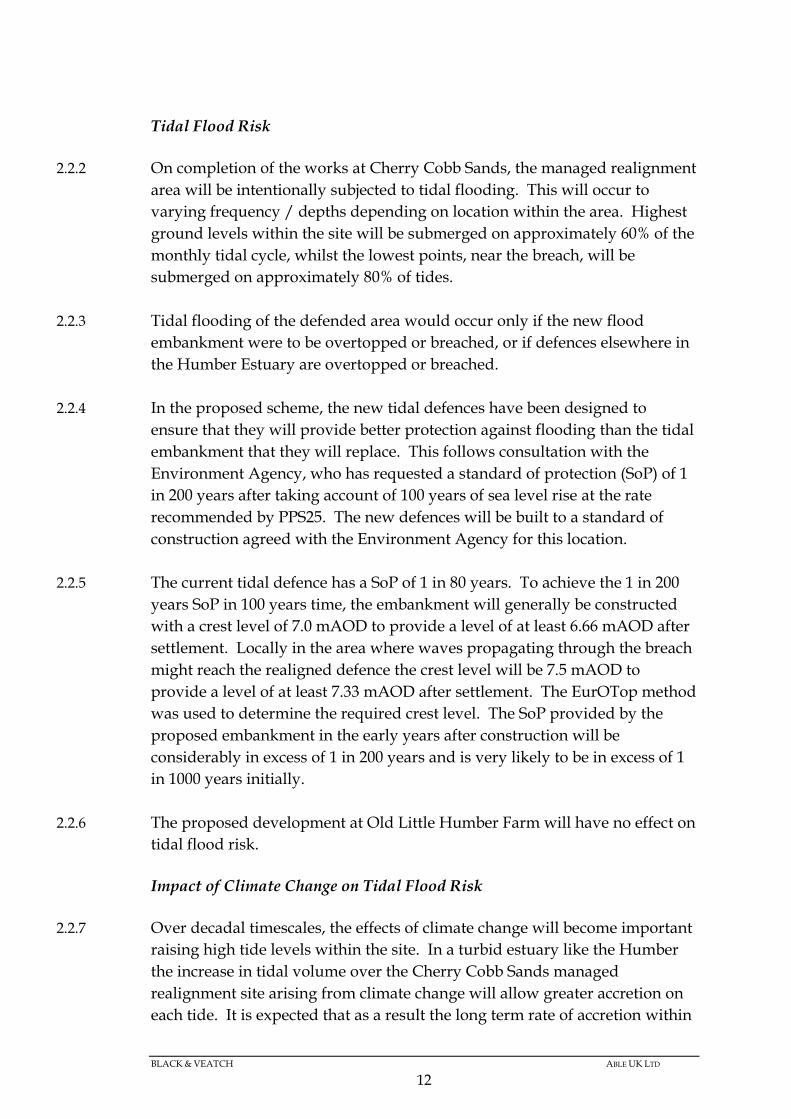
2.2.2 On completion of the works at Cherry Cobb Sands, the managed realignment
area will be intentionally subjected to tidal flooding. This will occur to
varying frequency / depths depending on location within the area. Highest
ground levels within the site will be submerged on approximately 60% of the
monthly tidal cycle, whilst the lowest points, near the breach, will be
submerged on approximately 80% of tides.
2.2.3 Tidal flooding of the defended area would occur only if the new flood
embankment were to be overtopped or breached, or if defences elsewhere in
the Humber Estuary are overtopped or breached.
2.2.4 In the proposed scheme, the new tidal defences have been designed to
ensure that they will provide better protection against flooding than the tidal
embankment that they will replace. This follows consultation with the
Environment Agency, who has requested a standard of protection (SoP) of 1
in 200 years after taking account of 100 years of sea level rise at the rate
recommended by PPS25. The new defences will be built to a standard of
construction agreed with the Environment Agency for this location.
2.2.5 The current tidal defence has a SoP of 1 in 80 years. To achieve the 1 in 200
years SoP in 100 years time, the embankment will generally be constructed
with a crest level of 7.0 mAOD to provide a level of at least 6.66 mAOD after
settlement. Locally in the area where waves propagating through the breach
might reach the realigned defence the crest level will be 7.5 mAOD to
provide a level of at least 7.33 mAOD after settlement. The EurOTop method
was used to determine the required crest level. The SoP provided by the
proposed embankment in the early years after construction will be
considerably in excess of 1 in 200 years and is very likely to be in excess of 1
in 1000 years initially.
2.2.6 The proposed development at Old Little Humber Farm will have no effect on
tidal flood risk.
Impact of Climate Change on Tidal Flood Risk
2.2.7 Over decadal timescales, the effects of climate change will become important
raising high tide levels within the site. In a turbid estuary like the Humber
the increase in tidal volume over the Cherry Cobb Sands managed
realignment site arising from climate change will allow greater accretion on
each tide. It is expected that as a result the long term rate of accretion within

BLACK & VEATCH ABLE UK LTD
13
the managed realignment will match sea level rise and so bed levels within
the site are expected to rise in line with sea level rise. This will have no
detrimental impact on the managed realignment area and is in line with the
project‟s main objective.
2.2.8 The SoP provided by the new embankment will reduce over time from sea
level rise due to climate change. However, the embankment crest levels have
been determined so that the SoP of the proposed defences will remain in
excess of 1 in 200 years in 100 years time.
2.2.9 Climate change will similarly reduce the SoP provided by tidal flood
defences elsewhere in this Flood Cell.
Fluvial and Surface Water Flood Risk
Cherry Cobb Sands
2.2.10 By realigning the Cherry Cobb Sands flood defence embankment, the fluvial
catchment area draining to Cherry Cobb Sands Drain will be reduced by up
to 100 ha (approximately 15% of the catchment). This will have a beneficial
impact on fluvial flood risk. The SFRA (Appendix B) identifies that areas of
historical fluvial flooding in the catchment of the Cherry Cobb Sands Drain
are mostly within the area of the proposed managed realignment site.
2.2.11 The SFRA (Appendix C) also identifies small areas within the proposed
managed realignment site adjacent to existing drains and water features as
being of „Low Hazard Severity‟ for surface water flooding.
2.2.12 A new soke dyke will be constructed between Cherry Cobb Sands Drain and
the new tidal flood embankment. This will capture any seepage through the
new flood defence embankment and any surface water runoff from the
landward face of the embankment. The new dyke will connect with the
existing flood defence soke dyke at the southwest corner of the site. This will
have a minor beneficial impact on surface water flood risk.
2.2.13 Fluvial or surface water flooding of the defended area could occur due to
excessive rainfall overwhelming the Cherry Cobb Sands Drain or the
Keyingham Drain. The proposed scheme reduces the area draining to
Cherry Cobb Sands Drain and will have no effect on the Keyingham Drain
except arising from siltation in Stone Creek that is discussed below.

BLACK & VEATCH ABLE UK LTD
14
Old Little Humber Farm
2.2.14 The proposed development at Old Little Humber Farm will create ridges and
furrows that will retain the rain falling on the land surface for longer than at
present. The stopping of the land drains in these fields will further reduce
the rate of percolation of rainwater from these fields into the surrounding
ditches. This will slightly reduce the runoff into the South Ends and Thorney
Crofts Drain following heavy rain and so help to reduce flood risk in the
catchment of this drain.
Findings on fluvial and surface water flood risk
2.2.15 Both parts of the Compensation Site will slightly reduce the fluvial and
surface water flood risk. Therefore this flood risk assessment does not assess
the risk of fluvial flooding from any of the drains and does not report the
standard of protection provided by any existing fluvial defences that may be
present along the watercourse upstream of the Compensation Site.
Siltation
2.2.16 The SFRA (Appendix A) identifies Keyingham Drain as having a „Localised
Drainage Issue‟. The Environment Agency, local land owners and tenants and
the local Drainage Boards in their Consultation Responses to the Preliminary
Environmental Impact Report (PEIR) all identified that there is a concern
about siltation in Stone Creek which if realised may adversely affect the
discharge capacity of the four drains that discharge into this creek. These
drains are clockwise from north to south: Cherry Cobb Sands Drain,
Keyingham Drain, Ottringham Drain and Sunk Island Drain.
2.2.17 Siltation within Stone Creek has been an issue in recent years and in January
2008 following the major floods in the summer of 2007 the Environment
Agency dredged Stone Creek. Since the dredging occurred, the Internal
Drainage Boards found that silt levels returned to their pre-dredge levels
within one year. The Internal Drainage Boards are pressing the Environment
Agency to dredge Stone Creek again, but have indicated that the
Environment Agency is resisting this demand on the grounds that the benefit
is not sufficient to justify the cost.
2.2.18 The likelihood of the development leading to changes in tidal levels or
increased siltation affecting the performance of the Stone Creek Outfalls is
considered in Chapter 32 of the Environmental Statement and Annex 32.4. An
agreed monitoring and maintenance plan (Environmental Statement paragraph

BLACK & VEATCH ABLE UK LTD
15
28.2.34) will be implemented to determine any impacts of the Compensation
Site on land drainage through Stone Creek. This plan will identify the
circumstances in which mitigation works will be undertaken.
Flood Hazard Zones
2.2.19 Cherry Cobb Sands is currently defended from flooding by tidal
embankments. Ignoring the presence of these embankments (as stipulated in
PPS25) would place the site in Flood Zone 3. As these embankments protect
adequately against the routine inundation of the site, the Environment
Agency has stated that it is not appropriate to classify the site as Functional
Floodplain (Flood Zone 3b). Therefore, the site is currently classified as
Flood Zone 3a (High Risk).
2.2.20 Upon completion of the scheme the managed realignment area will not be
defended, and will become Flood Zone 3b (Functional Floodplain). The
defended area will remain in Flood Zone 3a. This corresponds with the
SFRA, which shows the site lies within PPS25 Zone 3a.
2.2.21 The SFRA also identifies that in the event of a breach, the site lies in an area
of “Danger to All” and there would be <6 hours warning of a breach event.
The SFRA identifies the area of „Danger to All‟ as an approximately 700 m
wide buffer strip adjacent to the existing flood defence. Landward of the
area of „Danger to All‟ there is a further buffer of approximately 1000 m width
identified as „Danger to Most’, followed by a third 1000m buffer of „Danger to
Some‟. Together these buffer strips indicate a zone 2700 m wide of risk to
people landward of the existing Cherry Cobb Sands flood defence. The
width and location of these buffer strips is based on distance from the
defence and the mapping of the SFRA is reproduced on Figure 6 for the
existing defence alignment
2.2.22 The development at Old Little Humber Farm will not affect flood hazard and
this aspect is not considered further for this part of the proposed
Compensation Site.
2.3 APPLICABILITY OF THE SEQUENTIAL AND EXCEPTION TESTS
2.3.1 The applicability of the Sequential Test has been considered as part of this
FRA. Paragraph D1 of PPS25 states:
‘The risk-based Sequential Test should be applied at all stages of planning. Its aim is
to steer new development to areas at the lowest probability of flooding (Zone 1)’.

BLACK & VEATCH ABLE UK LTD
16
2.3.2 So, whilst the Sequential Test is applicable to all developments, its aim (i.e. to
steer development way from areas of high flood risk) is directly
contradictory to the needs of the proposed development. To operate
successfully this scheme must be in an area with a high probability of
flooding and has therefore been located within Flood Zone 3.
2.3.3 The alternative locations for the development of a managed realignment site,
all of which are in Flood Zone 3a, are discussed in Chapter 30 of the
Environmental Statement and Annexes 30.1 and 30.2.
2.3.4 The proposal is to create intertidal habitat and in the process provide a better
standard of flood protection than the existing tidal defence. Section 2.1 of
this FRA explains the objective to create intertidal habitat by allowing land to
flood and that the proposed land uses across the whole site comprise water
compatible development. Reference to Tables D.1 to D.3 of PPS25 shows that:
Water compatible development is appropriate in Flood Zones 3a and
3b.
PPS25 aims to create space for flooding. This aim matches the objective
of the Cherry Cobb Sands scheme.
The exception test is not required.
2.4 RESIDUAL FLOOD RISK AND FUTURE FLOOD RISK MANAGEMENT
Residual Flood Risk - On Site Impacts
2.4.1 Once the works are completed, the managed realignment area will be
routinely inundated during the tidal cycle; the development has been
designed to allow this area to flood to create intertidal wildlife habitats.
2.4.2 Members of the public will be able to traverse the site from a diverted Public
Right of Way along the landward toe of the new flood embankment. This
will replace the Public Right of Way along the crest of the existing defences.
Residual Flood Risk - Off Site Impacts due to overtopping
2.4.3 Since the flood defences for the proposed Cherry Cobb Sands site will be
higher than the existing flood defences, the risk to people associated with
overtopping of these defences will reduce.
2.4.4 The realignment of these defences will, however, bring them closer to Cherry
Cobb Sands Road and some nearby properties. The new embankment will
be situated at least 15 m from Cherry Cobb Sands Drain and include a soke
dyke to collect any water that does overtop the defences during an extreme

BLACK & VEATCH ABLE UK LTD
17
event. With both these watercourses between the embankment and Cherry
Cobb Sands Road, overtopping of the new embankment is unlikely to affect
users of Cherry Cobb Sands Road. The nearby properties are all at least 200
m from the realigned defence so will not be exposed to increased risk as a
result of overtopping.
2.4.5 Users of the realigned footpath along the landward toe of the new
embankment would be unlikely to be on this section of footpath during an
extreme event and would experience greater danger once they moved to the
existing embankment at either end of the realigned section where the
footpath is on the embankment crest and so directly exposed to wave
overtopping. If footpath users were caught unawares on the realigned
footpath they would be able to move away from the embankment toe
towards Cherry Cobb Sands Road.
Residual Flood Risk - Off Site Impacts due to breaching
Method and approach
2.4.6 The Off Site residual impacts due to a breach at Cherry Cobb Sands are
considered using a simplified approach in the ERYC SFRA. The flood
hazard associated with breaching of the existing defences is shown in Figure
6, which is redrawn from the SFRA. The Flood Hazard Zones are based on
the difference between the tidal water level and the local ground level. A
more complete understanding of this flood hazard might be gained by
breach modelling, but in an area of flat floodplain the effects of modelling are
likely to be limited to the width of each Flood Hazard Zone.
2.4.7 The Flood Hazard Zones associated with the development have been
assessed using the same simplified method. This is applicable as the flood
plain is a wide flat area and the land level behind the new defence is the
same as the level behind the existing defence. Breach modelling has not been
used to map the Flood Hazard Zones as it is likely that the findings would
show similar relative differences between the existing and with development
situations. In any event the landward realignment of the existing flood
defences will increase the flood hazard to nearby properties that are closer to
the realigned defence than the existing defence.
2.4.8 The change in flood hazard is discussed in the section Flood hazards associated
with breaching. The effect of the change in flood hazard on the Residual Risk
to People is discussed in the section Residual risk to people.
Effect of new development on probability of breaching

BLACK & VEATCH ABLE UK LTD
18
2.4.9 The present defences at Cherry Cobb Sands were substantially improved
around 25 years ago to a SoP reported as around 1 in 80. The proposed
defences will be raised and so the residual risk of breaching as a result of
overtopping will reduce.
2.4.10 The residual risk of breaching as a result of poor condition will also reduce
initially as the new defence will be built to standards agreed with the
Environment Agency and be of more recent construction than the existing
defence and so initially of improved condition grade.
2.4.11 With maintenance regimes in the future being carried out to standards
agreed with the Environment Agency, the condition grade of the new
defences should continue to be better than the older existing defences
because of the lower age of the new defence. This will ensure that the risk of
breaching due to poor condition is likely to be less for the realigned defence
than the existing defence until such time as the existing defences, upstream
and downstream of the realignment site, are improved in 40 years time, if
they are considered worthwhile improving at that time (paragraph 2.1.15).
Flood hazard associated with breaching
2.4.12 The other residual risk associated with breaching of the new defence at
Cherry Cobb Sands is that the new defence is set back from the existing
defence and so closer to nearby properties and infrastructure than the
existing defences.
2.4.13 Figure 6 maps the existing Flood Hazard Zones from the mapping in the
SFRA. The effect of realigning the flood defence on the Flood Hazard Zones
is shown in Figure 7. The width of each Flood Hazard Zone is unchanged as
the tidal water level and ground level are the same for the existing and
realigned defences. The Flood Hazard Zones have been moved to reflect the
changed alignment of the defences. Table 1 indicates the number of
properties in each zone with the existing defence and with the realigned.
The changed alignment of the flood defence moves 11 properties from the
„Danger to Most’ category to the „Danger to All’ category because of proximity
to the realigned defence.

BLACK & VEATCH ABLE UK LTD
19
Table 1 Numbers of properties in flood hazard zones
Hazard Zone Existing Realigned defence
Danger to All 2 13
Danger to Most 11 3
Danger to Some 6 3
Total 19 19
Residual risk to people
2.4.14 The Intermediate method of assessment outlined in FD 2320 provides a
method that includes consideration of the probability of failure within the
assessment. This identifies how Flood Hazard Zones and probability of
failure can be combined to assess the residual risk to people. This guidance
table is reproduced as Table 2 in this document.
Table 2 Flood risk to people behind defences (from FD2320)
Danger to
People
Annual probability of inundation
Prob ≥ 1% 1%> prob ≥
0.5%
0.5% >prob ≥
0.1%
Prob ≤0.1%
Danger to All High High High Medium
Danger to Most High Medium Medium Low
Danger to Some Medium Medium Low Low
Application to
this study
Existing
defences
Proposed
defence in +100
years
Not used Proposed
defence on
completion
2.4.15 The existing defence has an annual probability of failure that is >1 percent
(SoP of less than 1 in 100 years) and so the residual risk to people is based on
the first column of Table 2. All those living in the area covered by the
„Danger to All‟ and „Danger to Most‟ zones are considered to be at High
residual risk, while those in the „Danger to Some’ zone are considered at
Medium residual risk. For the existing defence alignment, the first column
of Table 3 indicates 13 properties are in the High Flood Risk to People
category and six in the Medium Flood Risk to People category.
2.4.16 The improved SoP of the proposed defence will reduce the annual
probability of failure so that it is very likely to be <0.1 percent (SoP > 1 in
1000 year return period) when first constructed. With rising sea levels, the
annual probability of failure will gradual increase, reaching 0.5 percent (1 in
200 year return period) after 100 years, assuming sea levels rise as

BLACK & VEATCH ABLE UK LTD
20
anticipated in PPS25 and there is continued maintenance of the realigned
defence in accordance with Environment Agency requirements.
2.4.17 The risk assessment with the improved and realigned defence is reported in
the second column of Table 3. This identifies 13 properties at Medium Flood
Risk to People and six in the Low Flood Risk to People category immediately
after completion, declining after 100 years to the same risk as the existing
alignment.
2.4.18 This risk assessment implicitly assumes that the existing defences would also
be raised to the standard of the new defences. In reality this will not occur so
the initial reduction in risk to people would be considerably less than
indicated in Table 3 because of the lengths of defence remaining at the
existing standard of protection.
2.4.19 The risk assessment in Table 3 shows an initial reduction in risk as a result of
the proposed realigned defence. This reduction in risk will reduce with time.
After 100 years, the effect of the realigned flood defence on the risk to people
is likely to be small.
Table 3 Number of properties in each Flood Risk to People category
Flood risk to
People
Existing Realigned defence*
On completion +100 years
High 13 0 13
Medium 6 13 6
Low N/A 6 N/A
Note * Method of interpretation implicitly assumes the existing defences are
at the same standard as the proposed defences
Future Flood Risk Management
2.4.20 The risk of flooding to the defended areas near Cherry Cobb Sands is
currently managed by the Crown Estate, although it has devolved this
responsibility to its tenants. The design and maintenance requirements for
the new defence will be as agreed with the Environment Agency.
2.4.21 The risk of flooding at Old Little Humber Farm is managed by the
Thorngumbald IDB. No changes to the current arrangements are planned.
When the results of the monitoring of the Compensation Site determine that
there is no further need for wet grassland at Old Little Humber Farm, the
land will be levelled, the field drains reinstated and arable farming will
recommence. The runoff from these fields after the wet grassland has been
replaced by arable farming will be similar to that experienced at present.

BLACK & VEATCH ABLE UK LTD
21
Figure 6 Current flood zone mapping at Cherry Cobb Sands from ERYC SFRA

BLACK & VEATCH ABLE UK LTD
22
Figure 7 Flood zone mapping at Cherry Cobb Sands with realigned defence

BLACK & VEATCH ABLE UK LTD
23
3 CONCLUSIONS
3.1.1 This Flood Risk Assessment has considered the risk of both tidal and fluvial
flooding at Cherry Cobb Sands and concludes the following:
The scheme will create areas of intertidal habitat that will be
intentionally flooded on spring tidal cycles.
The proposed tidal defences will provide a higher standard of
protection (SoP) than the defences they will replace.
The reduction in the fluvial catchment area draining to Cherry
Cobb Sands Drain should slightly reduce the probability of fluvial
or surface water flooding.
Residual flood risk mapping indicates that the improved standard
of the proposed defence will lead to an initial reduction in the risk
to people. After 100 years, the effect of the realigned flood defence
on the risk to people is likely to be small.
Siltation in Stone Creek is an issue of concern to consultees. An
agreed monitoring and maintenance plan (Environmental Statement
paragraph 28.2.34) will be implemented to determine any impacts
of the Compensation Site on land drainage through Stone Creek.
This plan will identify the circumstances in which mitigation
works will be undertaken.
3.1.2 This Flood Risk Assessment has considered the risk of fluvial flooding at Old
Little Humber Farm and concludes that:
The re-profiling of the land and the stopping of the field drains
will slightly reduce the probability of fluvial or surface water
flooding in South Ends and Thorney Crofts Drain.
When the need for wet grassland at this site no longer exists, the
land will be returned to arable farming and the flood risk will
return to its current level.
The Compensation Site Flood Risk Assessment, therefore, concludes that the
proposed development will have a minor beneficial impact on the flood risk
of the defended area.

BLACK & VEATCH ABLE UK LTD
24
4 BIBLIOGRPAHY
Planning Policy Statement 25: Development and Flood Risk. Communities and
Local Government, December 2006.
Planning for the Rising Tides: The Humber Flood Risk Management Strategy.
Environment Agency, March 2008. Available online (July 2009) at:
http://www.environment-agency.gov.uk/homeandleisure/floods/31704.aspx
EurOTop Wave Overtopping of Sea Defences and Related Structures, Assessment
Manual, August 2007.
Framework and Guidance for Assessing and Managing Flood Risk for New
Development, Flood Risk Assessment Guidance for New Developments, Defra/EA
Report FD2320/TR2, 2005.
Strategic Flood Risk Assessment (SFRA) Level 1, East Riding of Yorkshire
Council, January 2010.