Flood Induced Heavy Metal and Arsenic Contamination of Elbe River Floodplain Soils
11
Acta hydrochim. hydrobiol. 33 (2005) 5, 455−465 DOI 10.1002/aheh.200400591 455 Frank Krüger a , Flood Induced Heavy Metal and Arsenic Ralph Meissner b , Alexander Gröngröft c , Contamination of Elbe River Floodplain Soils Karsten Grunewald d Although the qualities of the river water and the sediments of the river Elbe have greatly a ELANA Soil Water Monitoring, improved over the past twenty years, both the suspended matter and the sediments are Dorfstr. 55, 39615 Falkenberg, still contaminated with heavy metals and arsenic (HM). This contamination exceeds the Germany b UFZ Centre for Environmental action values specified in the Federal Soil Protection and Contaminated Sites Ordinance Research Leipzig-Halle Ltd., (BBodSchV). The status of floodplain soil contamination with HM along the entire German Department of Soil Science, alluvial Elbe was investigated and evaluated, based on former research activities and Lysimeter Station, Dorfstr. 55, recently performed analyses after the extreme flood event in August 2002 and the sub- 39615 Falkenberg, Germany sequent winter flooding. The section downstream of the river Mulde inflow was contami- c University of Hamburg, Institute nated much higher than the upstream section. With the installation of permanently marked of Soil Science, Allende-Platz 2, observation areas a tool for soil quality monitoring has been established for the future. 20146 Hamburg, Germany d Technical University of Dresden, Institute of Geography, 01062 Dresden, Germany Die hochwasserbedingte Belastung der Auen mit Schwermetallen und Arsen ent- lang der Elbe Obgleich sich die Flusswasser- und Sedimentqualität der Elbe in den letzten 20 Jahren erheblich verbessert haben, sind die Schwebstoffe und schwebstoffbürtigen Sedimente immer noch hoch mit Schwermetallen belastet. Dies führt bei Bodenbildungen aus diesen Substraten häufig zur Überschreitung der in der Bundesbodenschutz- und Altlastenverord- nung (BBodSchV) festgelegten Maßnahmewerte. Basierend auf früheren Untersuchungen und aktuellen Erhebungen während des extremen Hochwassers vom August 2002 und des folgenden Winterhochwassers wurde der gegenwärtige Belastungsstatus der Böden in den Überflutungsgebieten entlang der gesamten deutschen tidefreien Elbe ermittelt und bewertet. Dabei war der Flussabschnitt unterhalb der Muldemündung wesentlich höher als der oberhalb gelegene belastet. Durch die Anlage dauerhaft markierter Beobachtungs- flächen wird es ermöglicht, in Zukunft Veränderungen des Stoffbestandes exakt zu erfas- sen. Keywords: Sediment, Cadmium, Mercury, Zinc, Distribution, Longitudinal Profile, Sampling Strategy, Monitoring Schlagwörter: Boden, Sediment, Cadmium, Quecksilber, Zink, Längsprofil, Proben- nahmestrategie, Monitoring Correspondence: F. Krüger, E-mail: [email protected] © 2005 WILEY-VCH Verlag GmbH & Co. KGaA, Weinheim
-
Upload
frank-krueger -
Category
Documents
-
view
213 -
download
0
Transcript of Flood Induced Heavy Metal and Arsenic Contamination of Elbe River Floodplain Soils

Acta hydrochim. hydrobiol. 33 (2005) 5, 455−465 DOI 10.1002/aheh.200400591 455
Frank Krügera, Flood Induced Heavy Metal and ArsenicRalph Meissnerb,Alexander Gröngröftc, Contamination of Elbe River Floodplain SoilsKarsten Grunewaldd
Although the qualities of the river water and the sediments of the river Elbe have greatlya ELANA Soil Water Monitoring,improved over the past twenty years, both the suspended matter and the sediments areDorfstr. 55, 39615 Falkenberg,still contaminated with heavy metals and arsenic (HM). This contamination exceeds theGermany
b UFZ Centre for Environmental action values specified in the Federal Soil Protection and Contaminated Sites OrdinanceResearch Leipzig-Halle Ltd., (BBodSchV). The status of floodplain soil contamination with HM along the entire GermanDepartment of Soil Science, alluvial Elbe was investigated and evaluated, based on former research activities andLysimeter Station, Dorfstr. 55, recently performed analyses after the extreme flood event in August 2002 and the sub-39615 Falkenberg, Germany sequent winter flooding. The section downstream of the river Mulde inflow was contami-
c University of Hamburg, Institutenated much higher than the upstream section. With the installation of permanently marked
of Soil Science, Allende-Platz 2,observation areas a tool for soil quality monitoring has been established for the future.20146 Hamburg, Germany
d Technical University ofDresden, Institute ofGeography, 01062 Dresden,Germany
Die hochwasserbedingte Belastung der Auen mit Schwermetallen und Arsen ent-lang der Elbe
Obgleich sich die Flusswasser- und Sedimentqualität der Elbe in den letzten 20 Jahrenerheblich verbessert haben, sind die Schwebstoffe und schwebstoffbürtigen Sedimenteimmer noch hoch mit Schwermetallen belastet. Dies führt bei Bodenbildungen aus diesenSubstraten häufig zur Überschreitung der in der Bundesbodenschutz- und Altlastenverord-nung (BBodSchV) festgelegten Maßnahmewerte. Basierend auf früheren Untersuchungenund aktuellen Erhebungen während des extremen Hochwassers vom August 2002 unddes folgenden Winterhochwassers wurde der gegenwärtige Belastungsstatus der Bödenin den Überflutungsgebieten entlang der gesamten deutschen tidefreien Elbe ermittelt undbewertet. Dabei war der Flussabschnitt unterhalb der Muldemündung wesentlich höherals der oberhalb gelegene belastet. Durch die Anlage dauerhaft markierter Beobachtungs-flächen wird es ermöglicht, in Zukunft Veränderungen des Stoffbestandes exakt zu erfas-sen.
Keywords: Sediment, Cadmium, Mercury, Zinc, Distribution, Longitudinal Profile,Sampling Strategy, Monitoring
Schlagwörter: Boden, Sediment, Cadmium, Quecksilber, Zink, Längsprofil, Proben-nahmestrategie, Monitoring
Correspondence: F. Krüger, E-mail: [email protected]
© 2005 WILEY-VCH Verlag GmbH & Co. KGaA, Weinheim

456 F. Krüger et al. Acta hydrochim. hydrobiol. 33 (2005) 5, 455−465
1 Introduction
The contamination of the holocene soils along the river Elbeis very high in several areas [1�10]. The intensity of con-tamination at a given floodplain site largely depends on thelocal flooding conditions during phases of high water as wellas on the quality of suspended matter and sediment of theriver at these times. Although the quality of the river waterof the Elbe has improved over the past twenty years [11],both the suspended matter and the sediments are still con-taminated with heavy metals and arsenic (HM). This con-tamination exceeds the limits, specified in the Federal SoilProtection and Contaminated Site Ordinance [12]. Recentlypublished data by Krüger and Gröngröft [13] on HM concen-trations in Elbe floodplain soils highlighted the wide range ofsoil contamination along the entire German Elbe. But regard-ing the fact that the sampling took place over the past twodecades and the morphological exposure and flooding fre-quency of individual positions are unknown the data neitherallow the direct comparison between different regions northe interpretation of the local variation in time.
Presumably the extreme flooding of the river Elbe in August2002 and the subsequent winter flooding have accumulatedenormous amounts of polluted sediments. The situation hadto be analysed in order to see how the flooding had affectedthe soil. For this purpose, sedimentation rates and HM fluxesin the Middle Elbe floodplains were conducted for the floodevents summer and winter 2002 and compared with pub-lished data from 1997 and 1998 by Rupp et al. [14]. Further-more, a uniform sampling strategy was developed to compilethe up-to-date status of soil contamination along the entireGerman tide-free Elbe section.
2 Materials and methods
2.1 Sediment loads
The sediment loads were determined by sediment traps (ar-tificial turf mats of 30 cm x 40 cm). Before flooding the sedi-
Table 1: Sampling sites for flood sediments.
Probenahmestandorte für Hochflutsedimente.
Name Place Stream km Morphological unit Sampling year
HFSDOMT04 Dommitzsch 170 Flood channel 2003HFSHAVT02 Havelberg 423 Groyne edge 2003HFS01 Schönberg Dike 438 Groyne edge 2002�03HFS14 Schönberg Dike 438 Depression 2002�03HFSSDT32 Schönberg Dike 438 Plateau 2002HFSSDT42 Schönberg Dike 438 Flood channel 2002�03HFSLUET01 Lütkenwisch 476 Flood channel 2003HFSGORT01 Gorleben 492 Low plain 2003
© 2005 WILEY-VCH Verlag GmbH & Co. KGaA, Weinheim www3.interscience.wiley.com/cgi-bin/jhome/5007772
ment traps were positioned at typical morphological posi-tions in the recent floodplain (Table 1) and were attached tothe ground with tent pegs. After the flooding the sedimenttraps were recovered, air-dried and then the sediments werebeaten out using a plastic rod. Composite samples weremade up from five replicates at each position. The sedimen-tation rates were determined by balancing the oven-dried(105 °C) material.
2.2 Soil sampling strategy
In close cooperation with the regional authorities in charge18 floodplain sites for the investigation of the HM distributionwere selected, which were nearly equidistantly distributedalong the German tide-free section of the river Elbe (Fig. 1).Beside of distribution in relation to tributary inflows criteriafor site selection were existing data and morphological diver-sity of the floodplains.
At each site the field studies started with a pedological tran-sect mapping across the floodplain supplemented by a level-ling of all positions in order to assess the flooding frequency.For example, Figure 2 shows the position of the transect onthe Glinde study site (km 301).
Based on the soil mapping 3 to 6 reference positions werechosen on each study site being representative for typicalmorphological (levees, flood channels, plateau areas) andusage units (grassland, arable fields, woodlands). The refer-ence positions differed in height above mean river water le-vel. As an example the location of the reference positionson the Ginde study site are shown in Figure 3. Figure 4 illus-trates the height of all studied positions with respect to themean water level. Below river km 200 the decreasing ele-vation of the floodplain areas corresponds to the expansion ofthe floodplain and the decrease in the water level amplitude.
For the purpose of long-time monitoring [15] the referencepositions downstream of Elbe km 128 were tacheometrically

Acta hydrochim. hydrobiol. 33 (2005) 5, 455−465 Flood Induced Heavy Metal Contamination of Floodplains 457
Fig. 1: Location of the study areasalong the river Elbe.
Lage der Untersuchungsgebieteentlang der Elbe.
Fig. 2: The Glinde study site, river Elbe km 301.
Das Untersuchungsgebiet bei Glinde, Stromkilometer 301.
surveyed and permanently marked. In contrast to the rec-ommendations by the task force “Key Information for SoilProtection” [16] and the BBodSchV [12], which promotes asampling of 1000 m2, the marked areas had a size of100 m2 or 256 m2, a rectangular shape and a minimum sidelength of 4 m. Normally the areas were even sided, but inrelation to the narrow and longitudinal morphological unitsthe areas could become 4 m x 64 m as well.
Composite top soil samples were produced from 10 or 16evenly distributed subsamples on a grid with a depth of0...10 cm (or 0...30 cm on arable land). Figure 5 gives thesampling grid of a square-sized reference position.
© 2005 WILEY-VCH Verlag GmbH & Co. KGaA, Weinheim www3.interscience.wiley.com/cgi-bin/jhome/5007772
2.3 Analysis
The soil and sediment samples were analyzed by the coop-erating laboratories using standard methods (see Table 2).The studies were all performed on the < 2 mm fraction.
3 Results
3.1 Sedimentation rates
After the high water in August 2002 mapping revealed thatrecent sandy depositions of a few centimetres thickness oc-curred only on soils on the river banks, especially atMühlberg (km 128) and Dommitzsch (km 170). On floodedsoils with more distance to the river or further downstreamsituated the sedimentation rates were much lower. On theMiddle Elbe floodplain site Schönberg Dike (km 438) onlyfine-grained muds rich in organic carbon with a thickness ofa thin film were observed. For this site Table 3 shows thesedimentation rates, measured with sediment traps in typicalmorphological positions for five high water situations since1997. The data indicate that during the summer flood 2002and the following winter flood 2002/2003 the sediment loadonto the alluvial soils (200...500 g/m2) was about twice ashigh as for the previous high water events studied. But thisis not true for a position directly on the banks (groyne edges)were sedimentation rates proved to vary extremely betweenhigh water events (127...8321 g/m2). The sedimentationrates were found to be lower than the long-time annual meanvalues (500...1500 g/m2 on plateau areas) determined for aMiddle Elbe position by a Zn balance method [20]. Becauseof the much higher suspended particulate matter load duringsummer 2002 sedimentation on the high-lying plateau areacould be measured (220 g/m2) the first time. The spring high

458 F. Krüger et al. Acta hydrochim. hydrobiol. 33 (2005) 5, 455−465
Fig. 3: Distribution of substratesand soil types on the Glinde studysite (km 301). The arrows indicatereference positions.
Verteilung der Substrate und derBodentypen im Untersuchungsge-biet Glinde (km 301). Die Pfeilezeigen die Lage der Monitoring-Standorte.
Fig. 4: Elevation of samplingpositions in relation to the meanwater level.
Höhenlage der Probenahmeflä-chen zum Mittelwasserstand derElbe.
Fig. 5: Sampling grid (circles) of a square-sized referencesite.
Probenahmeraster (Kreise) einer quadratischen Referenz-fläche.
© 2005 WILEY-VCH Verlag GmbH & Co. KGaA, Weinheim www3.interscience.wiley.com/cgi-bin/jhome/5007772
water 2003 was characterised by very low sedimentationrates (70...127 g/m2), which could be related to the lowerwater discharge. Comparative measurements at four othersites in the recent Elbe floodplains between km 170 to km492 confirmed the low sedimentation rates by the springflood in 2003 (data not presented).
3.2 HM contents in flood sediments
For the calculation of HM loads, the sedimentation rates onthe floodplain soil and the concentrations of HM in the sedi-ments need to be known. In Table 4 the HM concentrationsin recent flood sediments for high water events from 1997until 2003 are presented from a site that is representativefor the lower Middle Elbe. The data from the extreme floodevents in summer 2002 until winter 2002/2003 were inter-pretated together.

Acta hydrochim. hydrobiol. 33 (2005) 5, 455−465 Flood Induced Heavy Metal Contamination of Floodplains 459
Table 2: Methods of soil and sediment analyses.
Boden- und Sedimentuntersuchungsmethoden.
Parameter Method
pH Photometric measurement in soil suspension (CaCl2/KCl), DIN 19648 [17]
Total carbon Combustion at 970 °C and determination of change in thermal conductivity on an elementalanalyser (vario MAX, Elementar Analysensysteme) and wet combustion as described bySpringer and Klee [18]
Concentrations of trace metals Aqua regia digestion pursuant to DIN ISO 11466 [19] followed by measurement by atomicabsorption spectrometry(AAS3000 and FIAS400, Perkin Elmer)
Table 3: Sediment load (SL (dry matter) in g/m2) in the floodplain near Schönberg Deich (km 435...440; MW: above meanwater level).
Sedimenteintrag (SL (Trockensubstanz) in g/m2) am Standort Schönberg Deich (km 435...440; MW: über Mittelwasserstand).
High water Spring 1997 Autumn/winter Summer Summer/winter** Spring1998/99 2002 2002/03 2003
Maximum water discharge rate (m3/s) 1800 2360 3800 3260 1300SL at groyne edge (0.4 m MW) 3810 8321 1485 nsl* 127SL in flood channel (0.4 m MW) 204 242 nsl 405 70SL in depression (0.7 m MW) 298 397 nsl 502 78SL on plateau area (1.5 m MW) nsl nsl 220 nsl nsl
* nsl: no sediment load** Positions flood channel and depression were permanent flooded from summer 2002 until winter 2002/2003; for this reason
separate measurements of sedimentation rates were impossible.
Covering a period of seven years the data indicate a largelyconstant HM contamination of flood sediments. Trends inconcentrations are not obvious. For example, the medianw(Hg) and w(Cd) contents only fluctuate between3.8...4.9 μg/g and 5.5...8.4 μg/g, respectively. Compared tothe top soils of the floodplains the current HM contami-nations of the sediments are within the same range (cf.3.3.1).
For a standardised investigation of grassland soils the up-permost 10 cm have to be sampled. Calculating with a soildensity of 1 g/cm3, a topsoil layer of 10 cm consists of 100kg soil material on a square metre (m2). The sediment loadof 200...500 g/m2 even for the extreme flooding in August2002 in the region of the Middle Elbe causes just 0.2...0.5%of the analysed soil layer. Taking both sedimentation ratesand initial HM concentrations before flooding into account it
© 2005 WILEY-VCH Verlag GmbH & Co. KGaA, Weinheim www3.interscience.wiley.com/cgi-bin/jhome/5007772
can be predicted that the sedimentation from an individualflood event is unable to change the top soil quality of thefloodplain soils markedly.
3.3 HM contents of top soils
3.3.1 Assessment according to BBodSchV
The HM contamination of the recent floodplain soils alongthe Elbe and its tributaries is evaluated according the ‘triggervalues’ and ‘action values’ of the BBodSchV [12]. Forgrassland sites the action values have been defined in orderto limit the possible transfer of pollutants from the soil intofeeding stuffs. For agricultural sites the trigger values areused to secure a crop production with negligible pollutanttransfer. If trigger values are exceeded the soil is supposed

460 F. Krüger et al. Acta hydrochim. hydrobiol. 33 (2005) 5, 455−465
Table 4: HM contents in high-water induced flood sediments (site Schönberg Deich, km 435...440, highest median shownin bold).
Schwermetall- und Arsengehalte in Hochflutsedimenten (Standort Schönberg Deich, km 435...440, höchster Medianwert fett).
Year and qty. TOC As Cd Cr Cu Hg Ni Pb ZnUnit % μg/g
1997 Min 3.9 26 4.1 36 69 3.9 43 62 651n = 12 Med 11.4 41 6.6 106 112 4.9 53 127 1149
Max 23.1 107 11 134 146 6.2 76 420 1981
1998 Min 6.4 9.1 2.7 55 54 4.4 22 74 351n = 13 Med 7.7 25 5.5 110 130 4.5 51 126 816
Max 11 31 8.4 130 143 5.6 62 155 1082
2002/2003 Min n. d. 58 6.1 106 129 4.2 42 71 766n = 4 Med n. d. 68 8.4 210 144 4.6 79 128 834
Max n. d. 86 8.6 268 162 6.8 100 178 1157
2003 Min 4.2 27 4.2 84 62 3.0 55 139 710n = 6 Med 9.2 58 7.4 151 110 3.8 112 153 1007
Max 12.1 92 9.1 228 139 6.3 169 183 1022
to be impaired and further investigations are necessary. Incase of action value exceedance, soil contamination is gen-erally deemed to exist and the regional authorities in chargeof soil protection are obliged to carry out remediation, protec-tion or limitation measures.
The HM concentrations in recent floodplain top soils aresummed up in Table 5 for grassland and Table 6 for arableland. The sections of the river Elbe on both sides of the riverMulde inflow are shown separately because their level ofpollution varies considerably.
The action values for grassland soils are exceeded for As,Cu and Hg whereas for Cd, Ni and Pb all top soil values arebelow the action values, for Cr and Zn no values are defined.In the cases of As and Hg, the action values are exceededat 48% and 52% of the sites respectively; 16% of the sitescontain too much Cu for sheep grazing.
The problematic sites are mainly located on the Elbe sectiondownstream of the river Mulde inflow. Figure 6 shows thelongitudinal profile of Hg concentration of top soils along theElbe. Only 15% of sites downstream of the Mulde inflowhave a Hg level below the action value. The overwhelmingmajority of these sites are located in the Steckby study area(right bank, km 285), indicating that either the contaminatedsuspended matter input from the Mulde (left bank, km 259)is not completely mixed in the high water body, or that theSaale (left bank, km 290) is an even bigger source of the Hgfound in the Elbe. According to Federal Institute of Inland
© 2005 WILEY-VCH Verlag GmbH & Co. KGaA, Weinheim www3.interscience.wiley.com/cgi-bin/jhome/5007772
Water Research [21], in years with medium discharge ratesthe load of suspended matter in the Saale is about ten timeshigher than in the Mulde. All other sites without Hg ex-ceedance of action values are restricted to sandy embank-ments and a tilled plateau on the river Aland-mouth at km475, i.e. special sites of very small proportion within thefloodplains studied.
Figure 7 shows the As concentration of the floodplain topsoil along the river Elbe. Downstream of the Mulde inflow,the action values of As were exceeded at 59% of sites.There are just very few sites where the action value for Cuwere exceeded. On each of this sites high concentrations ofHg were also found.
In total, only four sites downstream of the Mulde inflow, (in-cluding three between Mulde and Saale inflow at km 285)complied with the action values of the BBodSchV [12].
In the floodplain soils of the Elbe upstream of the Muldeused as grassland, the action value of As was exceeded at 9out of 28 sites. This occurred along the Elbe from Zschieren/Pillnitz (km 41) downstream to Wörlitz (km 240) at differentelevations relative to the mean water level. With the flowdirection of the river Elbe the mean As contents in the flood-plain soils are increasing. In contrast to As, only 2 ex-ceedances were noted for Hg: in a flood channel in Wörlitz(km 240) and at the lowest site near Riesa (km 106).
Compared to the data presented by Krüger and Gröngröft[13] for the river Elbe floodplain soils prior to the flooding in

Acta hydrochim. hydrobiol. 33 (2005) 5, 455−465 Flood Induced Heavy Metal Contamination of Floodplains 461
Table 5: HM contents in grassland top soils in Elbe floodplains in 2003 (exceedances of action values according to BBodSchV[12] in bold).
Schwermetall- und Arsengehalte der Oberböden von Grünlandstandorten der Elbauen 2003 (Überschreitungen der Maßnah-menwerte der BbodSchV [12] fett).
River section As Cd Cr Cu Hg Ni Pb ZnPercentile μg/g
Total Elbe floodplains 10 25 1.3 65 34 0.4 28 61 222(km 23...493) 25 37 2.7 90 71 1.0 39 91 351n = 67 Median 50 4.8 113 104 2.1 53 130 604
75 65 7.9 150 163 7.7 68 175 99590 83 10 183 232 12 93 227 1191
Elbe floodplains downstream of the Mulde 10 31 2.9 87 82 1.5 36 91 380(km 259...493) 25 43 4.6 98 103 3.5 47 131 577n = 39 Median 55 7.5 127 146 6.1 58 163 941
75 66 9.3 166 205 11.0 73 205 115890 85 10 201 278 13.4 87 246 1235
Elbe floodplains upstream of the Mulde 10 19 1.0 42 26 0.2 13 50 146(km 23...242) 25 30 1.5 80 36 0.5 31 63 233n = 28 Median 43 2.8 91 66 0.9 41 94 377
75 55 3.7 119 98 1.5 65 122 58890 72 4.9 154 111 1.8 101 137 660
Action value for grassland 1300,50 20 200* 2 1900 1200
* Action value in case of sheep grazing
Table 6: HM contents in top soils of arable land in Elbe floodplains in 2003 (exceedances of test values according to BBodSchVin bold).
Schwermetall- und Arsengehalte der Oberböden von Ackerstandorten der Elbauen 2003 (Überschreitungen der Prüfwerte derBBodSchV fett).
As Cd Cr Cu Hg Ni Pb ZnPercentile μg/g
Total Elbe floodplains 10 11 0.6 28 13 0.1 11 28 100n = 18 25 13 0.8 39 17 0.1 18 42 124
Median 16 1.0 57 20 0.1 21 54 14275 23 1.5 86 32 0.5 39 65 22790 33 2.5 121 54 0.8 71 85 296Max 56 4.1 130 88 3.6 124 140 502
Trigger valuesfor arable land 200/50* 5
* 50 μg/g applies to soils that are sometimes waterlogged
2002, the actual data indicate a slight shift in contamination.The former maximum contents for w(Cd) = 30 μg/g , w(Hg) =30 μg/g and w(As) = 200 μg/g, respectively were not found
© 2005 WILEY-VCH Verlag GmbH & Co. KGaA, Weinheim www3.interscience.wiley.com/cgi-bin/jhome/5007772
in the this study. For Cd, Cr, Cu, Ni, Pb and Zn the medianvalues were enhanced for As equal and for Hg reduced(from w(Hg) = 3.5 to 2.1 μg/g). Regarding the high local

462 F. Krüger et al. Acta hydrochim. hydrobiol. 33 (2005) 5, 455−465
Fig. 6: Longitudinal profile of Hgcontents in recent floodplain topsoils in 2003.
Längsprofil der Hg-Gehalte inAuenoberböden 2003.
Fig. 7: Longitudinal profile of Ascontents in recent floodplain topsoils in 2003.
Längsprofil der As-Gehalte inAuenoberböden 2003.
variability of top soil contents with HM this shift has to beseen as a result of the sampling procedure. With this studythe first time a balanced sample distribution along the riveron the one hand and a comparative representation of mor-phological situations within the study sites on the other handwas achieved. The presented data on HM concentration aremore representative and can be better used for regionalcomparisons.
On arable lands within the floodplains the HM top soil con-centrations are considerably lower than for grassland lo-cations (compare Tables 5 and 6). This can be explained bythe way that arable land sites occupy the highest positionswithin the floodplains, where the sedimentation rates arelowest and where the contaminants are diluted into the top
© 2005 WILEY-VCH Verlag GmbH & Co. KGaA, Weinheim www3.interscience.wiley.com/cgi-bin/jhome/5007772
soil by ploughing. Moreover, most of the arable land withinthe river Elbe floodplains is situated in the section upstreamof the Mulde inflow (16 of 18 samples total). In addition, thetrigger value for Hg with respect to plant quality is muchhigher than the action value for grassland. Only in the caseof As for two positions top soil contents have been measuredwhich exceed the trigger value; for all other positions the topsoil contaminations with HM are uncritical according to theBBodSchV [12].
3.3.2 Correlation analyses and predictabilityof HM concentrations
For all samples the site parameters stream kilometre, dis-tance from the Elbe, elevation above mean water level and
Acta hydrochim. hydrobiol. 33 (2005) 5, 455−465 Flood Induced Heavy Metal Contamination of Floodplains 463
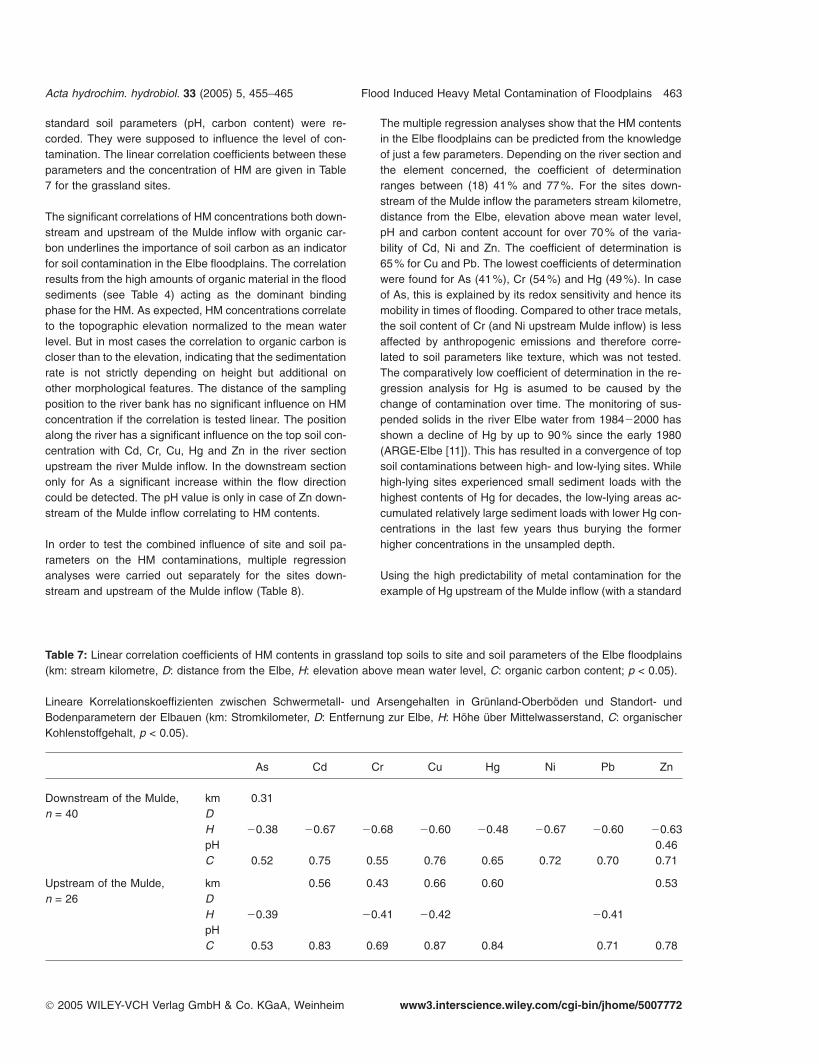
standard soil parameters (pH, carbon content) were re-corded. They were supposed to influence the level of con-tamination. The linear correlation coefficients between theseparameters and the concentration of HM are given in Table7 for the grassland sites.
The significant correlations of HM concentrations both down-stream and upstream of the Mulde inflow with organic car-bon underlines the importance of soil carbon as an indicatorfor soil contamination in the Elbe floodplains. The correlationresults from the high amounts of organic material in the floodsediments (see Table 4) acting as the dominant bindingphase for the HM. As expected, HM concentrations correlateto the topographic elevation normalized to the mean waterlevel. But in most cases the correlation to organic carbon iscloser than to the elevation, indicating that the sedimentationrate is not strictly depending on height but additional onother morphological features. The distance of the samplingposition to the river bank has no significant influence on HMconcentration if the correlation is tested linear. The positionalong the river has a significant influence on the top soil con-centration with Cd, Cr, Cu, Hg and Zn in the river sectionupstream the river Mulde inflow. In the downstream sectiononly for As a significant increase within the flow directioncould be detected. The pH value is only in case of Zn down-stream of the Mulde inflow correlating to HM contents.
In order to test the combined influence of site and soil pa-rameters on the HM contaminations, multiple regressionanalyses were carried out separately for the sites down-stream and upstream of the Mulde inflow (Table 8).
Table 7: Linear correlation coefficients of HM contents in grassland top soils to site and soil parameters of the Elbe floodplains(km: stream kilometre, D: distance from the Elbe, H: elevation above mean water level, C: organic carbon content; p < 0.05).
Lineare Korrelationskoeffizienten zwischen Schwermetall- und Arsengehalten in Grünland-Oberböden und Standort- undBodenparametern der Elbauen (km: Stromkilometer, D: Entfernung zur Elbe, H: Höhe über Mittelwasserstand, C: organischerKohlenstoffgehalt, p < 0.05).
As Cd Cr Cu Hg Ni Pb Zn
Downstream of the Mulde, km 0.31n = 40 D
H �0.38 �0.67 �0.68 �0.60 �0.48 �0.67 �0.60 �0.63pH 0.46C 0.52 0.75 0.55 0.76 0.65 0.72 0.70 0.71
Upstream of the Mulde, km 0.56 0.43 0.66 0.60 0.53n = 26 D
H �0.39 �0.41 �0.42 �0.41pHC 0.53 0.83 0.69 0.87 0.84 0.71 0.78
© 2005 WILEY-VCH Verlag GmbH & Co. KGaA, Weinheim www3.interscience.wiley.com/cgi-bin/jhome/5007772
The multiple regression analyses show that the HM contentsin the Elbe floodplains can be predicted from the knowledgeof just a few parameters. Depending on the river section andthe element concerned, the coefficient of determinationranges between (18) 41% and 77%. For the sites down-stream of the Mulde inflow the parameters stream kilometre,distance from the Elbe, elevation above mean water level,pH and carbon content account for over 70% of the varia-bility of Cd, Ni and Zn. The coefficient of determination is65% for Cu and Pb. The lowest coefficients of determinationwere found for As (41%), Cr (54%) and Hg (49%). In caseof As, this is explained by its redox sensitivity and hence itsmobility in times of flooding. Compared to other trace metals,the soil content of Cr (and Ni upstream Mulde inflow) is lessaffected by anthropogenic emissions and therefore corre-lated to soil parameters like texture, which was not tested.The comparatively low coefficient of determination in the re-gression analysis for Hg is asumed to be caused by thechange of contamination over time. The monitoring of sus-pended solids in the river Elbe water from 1984�2000 hasshown a decline of Hg by up to 90% since the early 1980(ARGE-Elbe [11]). This has resulted in a convergence of topsoil contaminations between high- and low-lying sites. Whilehigh-lying sites experienced small sediment loads with thehighest contents of Hg for decades, the low-lying areas ac-cumulated relatively large sediment loads with lower Hg con-centrations in the last few years thus burying the formerhigher concentrations in the unsampled depth.
Using the high predictability of metal contamination for theexample of Hg upstream of the Mulde inflow (with a standard

464 F. Krüger et al. Acta hydrochim. hydrobiol. 33 (2005) 5, 455−465
Table 8: Results of multiple regression analysis for the grassland sites along the Elbe (km: stream kilometre, D: distance fromthe Elbe, H: elevation above mean water level, C: organic carbon content, R 2: coefficient of determination, SFS : standard errorof estimation; significant relations p < 0.05 are printed in bold).
Ergebnisse der multiplen Regressionsanalyse für Grünlandstandorte entlang der Elbe (km: Stromkilometer, D: Entfernung zurElbe, H: Lage zum Mittelwasserstand, C: organischer Kohlenstoffgehalt, R 2: Bestimmtheitsgrad, SFS : Standardfehler derSchätzung; signifikante Beziehungen p < 0.05 fett).
River section Element Constant km D H pH C R2 SFSβ β β β β μg/g
Downstream of the Mulde, As 6.4 0.31 0.08 �0.03 �0.1 0.52 0.41 16n = 40 Cd �7.7 0.3 �0.14 �0.21 0.19 0.64 0.75 1.5
Cr 35.7 0.04 0.003 �0.49 0.19 0.26 0.54 34Cu �72.6 0.08 �0.12 �0.2 0.1 0.65 0.65 47Hg �16 0.17 �0.07 �0.06 0.2 0.61 0.49 3.8Ni 32.2 �0.18 �0.08 �0.42 0.16 0.45 0.71 12.7Pb �125 0.33 0.00 �0.17 0.12 0.61 0.65 39Zn �1106 0.16 �0.24 �0.2 0.34 0.6 0.77 180
Upstream of the Mulde, As 37.7 �0.56 0.14 �0.18 �0.06 0.81 0.45 20n = 26 Cd �0.57 0.004 �0.084 0.011 0.007 0.85 0.69 0.97
Cr 100.7 �0.07 �0.11 �0.08 �0.17 0.76 0.52 29Cu �30.9 0.06 0.05 �0.05 0.07 0.77 0.77 20Hg �0.52 0.05 �0.05 0.02 0.02 0.81 0.71 0.39Ni 79.7 0.07 �0.89 �0.16 �0.2 0.27 0.18 24Pb 67.4 �0.5 �0.03 �0.08 �0.09 1.05 0.65 26Zn �280.5 �0.17 0.26 �0.04 0.11 0.81 0.65 163
error of w(Hg) = 0.4 μg/g) the grassland-use with regard tosoil protection standards [12] can be estimated for large re-gions with few data. For the application of multiple re-gression equations in the regionalization of HM contents theinfluence of additional morphological parameters has to beproved.
4 Summary
The extreme flooding of the river Elbe in August 2002prompted us to work out a representative data set to assessthe contamination of the Elbe floodplains by heavy metalsand arsenic. In comparison to other flood events the floodingin August 2002 resulted in an increased sediment-borne HMinput in the lower Middle Elbe floodplain soils. However,these loads are to low to change the contamination statusin the soils significantly within the standardised samplingdepth.
The Elbe River floodplain soils accumulated high amountsof HM during at least the last century. The floodplain sectiondownstream of the river Mulde inflow is much higher con-taminated than the upstream section. In the lower section
© 2005 WILEY-VCH Verlag GmbH & Co. KGaA, Weinheim www3.interscience.wiley.com/cgi-bin/jhome/5007772
the action values for grassland-use as specified by theBBodSchV [12] are exceeded by As, Cu and Hg for 59%,12% and 85% of the studied soils, respectively. In the up-stream section top soil concentrations only for As werelarger than the action values (32% of sites). In respect tothe official trigger values, arable land areas within the recentfloodplains are mostly uncritical enriched with HM.
Although the sedimentation rate at the extreme flooding inAugust 2002 was observed to be very high in the upper sec-tion of the river Elbe, the change of top soil contaminationat individual sites could not be estimated owing to the lackof reference values. With a representative sampling of thetop soils and a permanent marking of the investigated sam-pling sites a tool for soil quality observation in the entire ElbeRiver floodplains was established for future research.
With multiple regressions analysis the predictability of topsoil HM contents from easy detectable parameters sepa-rately for both floodplain sections has been proven. Usingthe site parameters stream kilometre, distance from the Elbeand elevation above the mean water level and the soil pa-rameters pH and organic carbon the top soil contents forparticular HM can be predicted with a coefficient of determi-

Acta hydrochim. hydrobiol. 33 (2005) 5, 455−465 Flood Induced Heavy Metal Contamination of Floodplains 465
nation of up to 77%. The comparison between the param-eters revealed that in most cases the organic carbon contenthas the highest influence on the predictability. It is concludedthat with a more detailed consideration of the morphologicalforms of the floodplains the predictability of top soil HM con-tents can be further enhanced in the future and a mappingof large areas becomes possible.
References
[1] Friese, K., Witter, B., Brack, W., Büttner, O., Krüger, F.,
Kunert, M., Rupp, H.: Distribution and fate of organic and
inorganic contaminants in a river floodplain � results of a
case study on the river Elbe, Germany. In: Wise, D. L.,
Trantolo, D. J., Cichon, E. J., Inyang, H. I., Stottmeister,
U. (Eds.): Remediation and Engineering of Contaminated
Soils. Marcel Dekker, New York, 2000, pp. 373�426.
[2] Köster, W., Merkel, D.: Schwermetalluntersuchungen land-
wirtschaftlich genutzter Böden und Pflanzen in Nieder-
sachsen. Landwirtschaftskammer Hannover, 1985.
[3] Krüger, F.: Unpublished Hg-measurements of top soils,
1997.
[4] Krüger, F.: Unpublished data of soils and plants, 2001.
[5] Küster, J.: Bestimmung der pflanzenverfügbaren Schwer-
metallgehalte in ausgewählten Elbvordeichsböden unter
besonderer Berücksichtigung des Transfers Boden/
Pflanze. Diplomarbeit, Universität Hamburg, 1996.
[6] Landesamt für Umweltschutz Sachsen-Anhalt: Unpub-
lished measurements of Elbe River floodplains soils and
plants, 2000.
[7] Landesumweltamt Brandenburg: Pollution of Soils, Crops
and Animal Products from Elbe River Floodplains.
Potsdam, 2000.
[8] Meissner, R., Guhr, H., Rupp, H., Seeger, J., Spott, D.:
Schwermetallbelastung von Böden und Elbsedimenten in
ausgewählten Gebieten Ostdeutschlands. Z. Kulturtech.
Landentwicklung 35, 1�9 (1994).
[9] Miehlich, G.: Schwermetallanreicherung in Böden und
Pflanzen der Pevestorfer Elbaue. Abh. Naturwiss. Verein
Hamburg 25, 75�89 (1983).
[10] Müller, D.: Erfassung und Bewertung von Bodenbelas-
tungen durch anorganische Schadstoffe im Überflutungs-
© 2005 WILEY-VCH Verlag GmbH & Co. KGaA, Weinheim www3.interscience.wiley.com/cgi-bin/jhome/5007772
gebiet oberes Elbtal. Diplomarbeit, Martin Luther Univer-
sität Halle Wittenberg, 1995.
[11] ARGE-Elbe: Tables of Measurements. Arbeitsgemein-
schaft für die Reinhaltung der Elbe, Hamburg,
1984�2000.
[12] Federal Soil Protection and Contaminated Sites Ordinance
(Bundesbodenschutz- und Altlastenverordnung,
BBodSchV) from 12.07.1999.
[13] Krüger, F., Gröngröft, A.: The difficult assessment of heavy
metal contamination of soils and plants in Elbe River flood-
plains. Acta Hydrochim. Hydrobiol. 31, 436�443, 2003.
[14] Rupp, H., Krüger, F., Büttner, O., Kunert, M., Meissner, R.,
Muhs, K., Witter, B., Friese, K.: Impact of High Flood
Events on Floodplain and Agricultural Soil Contamination
from Oka and Elbe. Final Report of a BMBF Funded
German-Russian Project, FKZ 02 WT 9617/0, 2000.
[15] Krüger, F., Gröngröft, A., Grunewald, K., Meissner, R.,
Miehlich, G., Petzoldt, H., Unger, C.: Impact of contami-
nants and pathogenes of high flood sediments on soils and
plants. Final Report of a BMBF Funded Project, FKZ:
0330492, 2004.
[16] Task Force for Key Information for Soil Protection/Sonder-
arbeitsgruppe Informationsgrundlagen Bodenschutz: Kon-
zeption zur Einrichtung von Boden-Dauerbeobach-
tungsflächen. In: Rosenkranz et al. (Eds.): Bodenschutz.
Ergänzendes Handbuch. Erich Schmidt, Berlin, 1993.
[17] DIN 19684-1: Determination of pH value of the soil and
lime requirement. 1977.
[18] Springer, P., Klee, E.: Feststellung der optimalen Reak-
tionsverhältnisse beim reduktometrischen Chromschwefel-
säureverfahren zur Schnellbestimmung von Kohlenstoff
und Vorschlag einer verbesserten Arbeitsweise. Z. Pflan-
zenern., Düngung, Bodenkd. 71, 193�208, 1954.
[19] DIN ISO 11466: Extraction of trace elements soluble in
aqua regia. 1997.
[20] Schwartz, R.: Die Böden der Elbaue bei Lenzen und ihre
möglichen Veränderungen nach Rückdeichung. Disser-
tation. Hamburger Bodenkd. Arbeiten 48, 2001.
[21] Naumann, S., Schriever, S., Möhling, M., Hansen, O.,
Gölz, E.: Bedeutung der Nebenflüsse für den Feststoff-
haushalt der Elbe. Final Report, FKZ 0339600/1, Bundes-
anstalt für Gewässerforschung-1382, 2003.
[Received: 12 October 2004; accepted: 25 January 2005]