
FLOOD HAZARD ASSESSMENT FOR SARPANG DZONGKHAG
66
i FLOOD HAZARD ASSESSMENT FOR SARPANG DZONGKHAG FLOOD ENGINEERING AND MANAGEMENT DIVISION, DEPARTMENT OF ENGINEERING SERVICES MINISTRY OF WORKS AND HUMAN SETTLEMENT YEAR 2019 Reviewed By: Tshering Tashi, Ex. Engineer, FEMD, DES, MoWHS
Transcript of FLOOD HAZARD ASSESSMENT FOR SARPANG DZONGKHAG

i
FLOOD HAZARD ASSESSMENT FOR SARPANG DZONGKHAG FLOOD ENGINEERING AND MANAGEMENT DIVISION,
DEPARTMENT OF ENGINEERING SERVICES
MINISTRY OF WORKS AND HUMAN SETTLEMENT
YEAR 2019
Reviewed By: Tshering Tashi, Ex. Engineer, FEMD, DES, MoWHS

ii
Table of Contents
Acknowledgement 1
Acronyms 2
Executive Summary 3
Introduction 4 Background 4
Objective of the Study 15
Methodology 20
Data Collection and Assessment 21 Hydrological and Meteorological Data 21
Hydro-Met Data 21 DEM (Digital Elevation Model) 22 Land cover Data 22
Site Assessment of the Study Area 22 Shompangkha Gewog in Sarpang Dzongkhag 22
Past Flood Event in The Study Area 38 Identifying Critical River 49 River Cross-Section Survey 50
Development of Model 51 Hydrodynamic Model (HEC-RAS) 51
Result Analysis and Conclusion 53
Recommendation for flood management 55
Interventions 56
Limitations 61
References 62

iii
Figure 1: Bhutan Map showing the area of Interest (Sarpang). ...................................................... 4 Figure 2: Daily Maximum Rainfall (mm) in Sarpang Station. ..................................................... 16 Figure 3: Total Monthly Rainfall recorded at Sarpang Station. .................................................... 16 Figure 4 : Hazard Map for Sarpang Township. ............................................................................ 18 Figure 5: Flood event in Sarpang Dzongkhag .............................................................................. 19
Figure 6: Sarpang Chhu with its tributaries. ................................................................................. 24 Figure 7: Critical areas along Sarpang Chhu. ............................................................................... 25 Figure 8: Flood prone areas in Gakiling Gewog. .......................................................................... 26 Figure 9: (a) Tinpati Khola (b) Leukhola and (c) Dholkhola ....................................................... 27 Figure 10: (a) Big Aipoly and (b) Bhur Khola. ............................................................................ 29
Figure 11: Threat from the Paithra Khola. .................................................................................... 29
Figure 12: Detention pond and floodway in Gelephu. .................................................................. 30 Figure 13 : Mao River in Gelephu with its tributaries. ................................................................. 32
Figure 14: (a) Source of Shetikheri (b) Landslide at source. ........................................................ 33
Figure 15: (a) Scour depth on the pillars (b) Debris collected at the downstream of Shetikheri. . 33 Figure 16: Past interventions along Shetikheri (Gabion walls and floodways). ........................... 34 Figure 17: (a) Dowla Khola and (b) Jogi Khola. .......................................................................... 35
Figure 18 : (a) Left Bank and (b) Right Bank. .............................................................................. 35 Figure 19: (a) Thewar Khola and (B) Masana Khola in Shershong Gewog. ............................... 36
Figure 20 : (a) Mao River and (b) Jangkurung Chhu.................................................................... 37 Figure 21: (a) Flowpath in 2010 (b) Flowpath in 2013. ............................................................... 37 Figure 22: Agricultural field on the left bank of Taklai Chhu. ..................................................... 38
Figure 23: Destruction caused by the flood in July, 2016. ........................................................... 39
Figure 24 : Original river course (along the right bank) before the flooding of July, 2016. ........ 40 Figure 25: Sarpang Chhu changed its course towards the left bank (During Flood). ................... 41 Figure 26: Mao River flowing towards the Infiltration Gallery. .................................................. 42
Figure 27: Destructions caused by Mao River near the Infiltration gallery. ................................ 43 Figure 28: Settlements along Shethikheri affected by the flood. .................................................. 44
Figure 29: Destructions caused by the Shetikheri stream. ............................................................ 45 Figure 30: Damaged wall and affected paddy field locations. ...................................................... 45 Figure 31: Paddy field damage location at Gadhen and Linger Village. ...................................... 46
Figure 32: Minor landslide and scouring along Jangkurung chu. ................................................. 47 Figure 33: Bhur rainfall events. .................................................................................................... 48 Figure 34: Shershong rainfall events. ........................................................................................... 48
Figure 35: Annual maximum rainfall at Bhur and Shershong. ..................................................... 49 Figure 36: Sarpang Chhu cross-section survey ............................................................................. 50
Figure 37: Geometric data used in the River Analysis of Sarpang Chhu. .................................... 52 Figure 38: River Cross-section showing the water level. ............................................................. 53 Figure 39: Preliminary flood hazard mapping for different discharges. ....................................... 54 Figure 40: (a) Exit of the detention basin (b) Baffle walls at the entrance. .................................. 56 Figure 41: Flood damages along small Aipoly. ............................................................................ 57
Figure 42: Typical cross section of a gabion revetment ............................................................... 60

iv
Table 1: Historic flooding events reported by the Sarpang Dzongkhag and Local Government ... 5 Table 2: Historic flooding events reported by the Media ............................................................. 14 Table 3: Discharge of different return period for Sarpang. .......................................................... 21 Table 4: Critical areas under threat from erosion in Shompangkha Gewog. ................................ 23 Table 5: Critical flood prone areas in Gakiling Gewog. ............................................................... 25
Table 6: Critical flood prone area in Dekiling Gewog. ................................................................ 27 Table 7: Flood prone areas in Samtenling Gewog. ....................................................................... 28 Table 8: Flood prone areas in Gelephu Gewog. ........................................................................... 31 Table 9: Flood prone areas in Sershong Gewog. .......................................................................... 36 Table 10: Flood prone areas in Umling Gewog. ........................................................................... 38
Table 11 : Estimated Damages for Sarpang Chhu Flood Protection Works................................. 41
Table 12: Discharge of different Return period for Sarpang ........................................................ 51 Table 13: Estimated damage for detention pond (Small Aipoly). ................................................ 56
Table 14: Estimated Damage for floodway (Small Aipoly). ........................................................ 58
1
Acknowledgement
Flood Engineering and Management Division under Department of Engineering Services,
Ministry of Works and Human Settlement have taken immense initiative and efforts in carrying
out flood hazard assessment for Sarpang Dzongkhag and preparation of the Flood Hazard Map
for Sarpang Chhu in Sarpang Dzongkhag. The Division has successfully completed this project
on time. However, it would not have been possible without the valuable support, guidance and
help of many individuals and organizations. Therefore, we would like to extend our sincere
thanks and appreciation to all of them:
1. National Center for Hydrology and Meteorology, Ministry of Economic Affairs, Bhutan
2. National Statistical Bureau, Bhutan
3. Dzongkhag Administration, Sarpang Dzongkhag
4. Gelephu Thromde
The Flood Engineering and Management Division would also like to acknowledge and thank all
those who have contributed and willingly helped us with their abilities towards carrying out the
flood hazard assessment studies for Sarpang Dzongkhag.

2
Acronyms
FEMD Flood Engineering Management Division.
HEC-RAS
The Hydrologic Engineering Centre, River Analysis System is a computer
program that models the hydraulics of water flow through natural rivers
and other channels. The program is one-dimensional, meaning that there is
no direct modelling of the hydraulic effect of cross section shape changes,
bends, and other two- and three-dimensional aspects of flow. The program
was developed by the US Department of Defence, Army Corps of
Engineers in order to manage the rivers, harbours, and other public works
under their jurisdiction; it has found wide acceptance by many others since
its public release in 1995.
GIS Geographical Information System is a computer-based method for
analysing geographical information and maps.
FHM Flood Hazard Map
FRA Flood Risk Assessment.
AFA Areas for Further Assessment.
MoAF Ministry of Agriculture and Forest.
DDM Department of Disaster Management.
GLOF Glacial Lake Outburst Flood.

3
Executive Summary
The Sarpang Chhu flowing from North to South before entering the Indian territory passes in
between the two towns Sarpang on the left bank and Shechangthang (Ranibagan) on the right
bank. The river has a notorious history of often getting swollen and causing havoc to the
inhabitants in the vicinity. The River changes its course frequently, resulting in its banks getting
wider and shallower day by day, and bringing in huge amounts of silt deposits in summer season.
During the recent flooding in the year 2016, Sarpang Bazaar (Makeshifts) was completely
washed away, with the ongoing flood protection works and stretches of Sarpang-Gelephu
Highway also getting washed away, incurring financial loss of almost Nu.25 Million to the
Government.
Therefore, the FEMD had initiated to undertake Flood Hazard Assessment of the Sarpang
Dzongkhag with the main objective to achieve as follows:
• Flood hazard assessment in Sarpang Dzongkhag and identify areas vulnerable to
flooding in the face of climate change and variability.
• Analyse the AoMI (Areas of Mitigation Interest) assessment in Sarpang Dzongkhag and
identify and prioritize critical flood prone areas within Sarpang Dzongkhag.
• Recommend appropriate flood protection measures along the identified flood prone
areas.
The FEMD has also prepared a Flood Hazard Map for the Sarpang Chhu using the
hydrodynamic Modeling i.e HECRAS. Due to many limitations, the Flood Hazard Map for
Sarpang Chhu is in its preliminary form and needs to be updated in due course of time.
Other critical rivers under Sarpang Dzongkhag such as Mao River, Shetikhari and Aipoly
streams under Gelephu are being taken up as separate studies. Therefore, this Report, presents
critical areas in Sarpang Chhu under Shompangkha Gewog, Sisty Khola under Gakidling Gewog
and Taklai River under Umling Gewog as Areas of Mitigation Interest and recommends for flood
mitigations works.
In the past, different types of Interventions were implemented in Sarpang Dzongkhag, such as
AB Mattress embankments, Gabion walls etc, However, for this study, Gabion Revetment type
of flood interventions are recommended for the identified Areas of Mitigation Interest.

4
Introduction
Background
Figure 1: Bhutan Map showing the area of Interest (Sarpang).
The Sarpang Dzongkhag is situated in the central southern foothills bordering India with a
Latitude of 26°52' N and Longitude 90°16' E. The Dzongkhag shares about 200 km of common
border with the Indian state of Assam to the south and the Dzongkhags of Tsirang and Dagana to
the west, Zhemgang to the east and Trongsa to the north. The total geographical area of the
Dzongkhagis approximately1660.28 Sq.km and has undulated terrain. The Sarpang Dzongkhag
is administratively supported by a Gelephu Dungkhag and consists of 12 Gewogs. Services and
administrative support for five Gewogs, Gakiling(Hilley), Dekiling, Singye, Chhudzom (Dovan)
and Shompangkha are provided from Dzongkhag headquarter. While seven Gewogs namely,
Gelephu, Chuzargang,Umling, Sershong, Taraythang, Jigmechoeling and Samtenling (Bhur) are
provided by Gelephu Drungkhag.1
The major crops cultivated in the area are paddy, maize, wheat, and millet. Orange, areca nut,
cardamom and ginger are also grown as principal cash crops by the farmers of the Dzongkhag.
Favourable terrain and climatic conditions combined with fertile agriculture land offer
tremendous opportunity for farm mechanization and commercial horticultural development.
1Annual Dzongkhag Statistics 2011, Sarpang Dzongkhag, National Statistics Bureau.

5
Table 1: Historic flooding events reported by the Sarpang Dzongkhag and Local Government
Sl.No
.
Name of
Village Name of Geog
Name of
river/stream
Type of
threat
(Agriculture
/Resident
Estimated
Population
Past
flooding
record
1 Daangling
Umling
Langkhar-chu Agriculture 20
(The area lies
in between
these 2
villages)
monsoon
floods yearly
washes the
land near by
the river
2 Doongmin Langkhar-chu Agriculture 20 do
3 Gaden Taklai-chu Agriculture 550 2007
4 Rijong Langkhar-chu Agriculture 350
yearly
monsoon
5 Chhuborshong
Talai-chhu &
Jangkhrung-
chu Agriculture 200
6 Chhuborshong Langkhar-chu Agriculture 50
yearly
monsoon
7 Thongjazor Langkhar-chu Agriculture 20
yearly
monsoon
8 Yoezergang Tareythang
Singye-chu Agriculture 30 h/h 9 Yoezergang Singye-chu Forest
10
Upper
Karbithang
Chuzagang
Mou river
Agriculture
145 Once(2009)
11
Lower
Dawathang Seasonal river 200 Every year
12
Lower
Dawathang Seasonal river 150 Every year
13 Dawathang Taklai river 150 Once
14 Pangzor Seasonal river 50 Every year
15
Lower
Karbithang Mou river
Agriculture/for
estry and
residential 95 Every year
16 Chaskar Mou river Agriculture 31 17 Chaskar Thewar river Agriculture 12 once(1996)
18 Chaskar Martshani river Agriculture 5
19 Daragaon Jigmecholing
Heti Khola
Agriculture/for
estry and
residential 30h/h
20 Chungsing Howangmay Agriculture 5h/h
Landslide
during the
year 2000

6
21 Chungsing
Nabchali Chu Agriculture 6 h/h
Landslide
during the
year 1997
22 Bartsham Kha jantikhola Forestry 7 h/h
Landslide
during past
year(around
1994)
23 Ossey jantikhola
Forestry &
residential 10h/h
landslide
during the
year 2001
24 Tormay Ratipani Forestry 12h/h
landslide
during the
year 1998
25 Sukumbasi Ratipani
Agriculture
4h/h
landslide
during the
year 2001
26 Pakhey Ratikhola 7h/h
landslide
during the
year 1975
27 Bhirgaon Ratikhola 5h/h
landslide
during the
year 1988
28 Reti
Reti chu
Agriculture
& forestry 7h/h
landslide
during the
year2009
29 Kholatar
Agriculture
& forestry 4h/h
landslide
during the
year2004
30 Mongargaon
Agriculture
& residential 6h/h
Soil erosion
in the year
2010
31 Gairigaon 'A'
Agriculture
& residential 12h/h
Landslide in
the year 2010
32 Gairigaon 'B'
Agriculture
& residential 6h/h
Landslide in
the year 2000
33 Gogtsekha
Agriculture
& residential 6h/h
Landslide in
the year 2009
34 Garigaon'C'
Forestry &
Agriculture 9h/h
Landslide in
the year 1992
35 Batasey'A'
Agriculture
& residential 4h/h Landslide
36 Samkhara'A' Beteni river
Agriculture
& residential 6h/h Landslide
37 Beteni Rongchu
Agri.
Forestry &
residential 4h/h Landslide
38 Samkhara'B'
Agriculture
& residential 5 h/h Landslide

7
39 Batasey'B'
Agriculture
& residential 3 h/h Landslide
40 Samkhara 'C'
Agriculture
& residential 6 h/h Landslide
41 Tormay Labray stream
Agriculture
& residential 7h/h Landslide
42 Lekithang
Gelephu
Sanu Aipoli Kamzhing 80
2 times,
heavy flood
in 2010.
43 Pemathang Setikhari
Residential/K
amzhing 1500
Heavy flood
in 2000 &
2010. This
stream is
main risky
44 Dzomlingthang Setichu
Residential/K
amzhing 250
Heavy flood
in 2000 &
2010.
45 Dawlachu
Pelrithang
Khamey
Chuzhing/Ka
mzhing/resid
ential 1200
Heavy flood
in 2000 &
2010. Then
flood will
affect
Pelrithang
Middle
Secondary
School(total
students-
1000 plus)
46
Pelrithang
Khatoe Jogichhu
Chuzhing/Ka
mzhing/resid
ential 100
More of
Chuzhing
will be
affected
47
Pelrithang
Khatoe Passang Chu
Residential &
Water Supply 150
Including
RBA officer
qtr. And the
office
48
Pelrithang
Khatoe AnderiKholsa
Government
Land(GRF) 200
RBP jail and
PWD
workers
49 Samtenthang
Samtenling
Paithakhola Agriculture
Major
disaster in the
year 2010
50 Samtenthang Rana Kholse
Orange
Orchard
Landslide
occurred in
the year
51 Samtenthang Aipoli
Agriculture,
forestry
Flood
occurred in
the year 2010

8
52 Samtenling Paithakhola Agriculture 47
53 Samtenling Gowa Kholse
Residential,
Agriculture 3
Yr. 2000,
house was
taken away
by the flood.
July 2010,
house was at
risk due to
heavy
downpour
54 Dechen Pelri Shetikhari Forestry
Major
landslide at
water source
area
benefiting
Dechenpelri
area
55 Chhokorling Aipoli Kholsa
Orange
Orchard
Orchard of
Purna Bdr.
Rai at risk
56 Khenpagang Kopche Khola
Orange
Orchard,
forestry
57 Paithakhola Paithakhola
Orange
Orchard,
forestry
Orchard of
Budhiman
Rai at risk
58 Pangkhar
Sershong
Pemaling chu Dry land 21
incidence
took place
in2005 &
2009
59 kapong Pemaling chu
Dry land &
wet land 30
incidence
took place
2010
60 sershong Mau chu
Dry land &
wet land 79
incidence
took place
past 15 years
61 sershong Threwar chu
Orange
orchard 17
incidence
took place
2008
62 sershong Thremola chu
Dry land &
wet land 35
incidence
took place
2007
63 Tashiphu
Jangkhurung
chu Dry land 76
incidence
took place
2005
64 Tashiphu Tashiphu chu Wet land 134
Heavy
incidence
took place
2009

9
65 Tashiphu
Jangkhurung
chu Dry land
Lhakhang
area
incidence
took place
2009
66 Barshong Masani chu Wet land 133
incidence
took place
2009
67
Relangthang
(Noonpani)
Gakidling
Khaney Wet land 21 in 2000
68 Getemkha Laring river Govt. land
in 1996,
2006, 2010
69 Kalikhola
Kharey
Kholsa
Dry & wet
land 26
2006
continues
every year
70
Gakidling(Hille
y) Gurung Khola Wet land 31 2000 & 2010
71
Gakidling(Hille
y)
Chowen
Kolsee Wet land 21 2010
72 Bunakha(Bisty) Bistee Khola
Wet & dry
land 25 2010
73 Kami Dara Gurung Khola Dry land 16
2009 &
2011(landslid
e)
74 Fokforay Devi Kholsa Wet land 11 1993
75 Hadisay
Hadisay
Kholsa Dry land 5 2009
76 Khaharay
Khahara
Khola
Orange
Orchard 6 2010
77 Piling
Thotnay
Khola Wet land 21 2007 & 2011
78 Khaharay
Khaharay
Khola Govt. land 1996
79
Khaharay
Kusumay
Khaharay
Khola
Orange
Orchard 14 2010
80 Bimberay
Kataray
Kholsa Dry land 16 1996 & 2007
81 Bimberay
Kafaray
Kholsa &
majitay
Kholsa Dry land 16 2007
82 Yangchenphu
Dekiling
Yangchu
Govt. land. &
agricultural
land 10h/h 2000 & 2010
83 Darbithang
Hamchu/Leok
hola
Agricultural
land 8h/h 2001 & 2010
84 Trashiling
Arnekhola/ma
hechu
Agricultural
land 8h/h 2002 & 2010
85 Darbithang
Leokhola/ham
chu
Agricultural
land 10h/h 2000 & 2010
86 Darbithang Sukhakhola Agricultural 6h/h 2001 & 2010

10
& residential
87 Doloungang
Bichkhola
Agriculture
land
(damaged
irrigation
channel in
past) 10h/h 2002 & 2010
88
Menchungthang/
rateygoen
Rateykhola
Agricultural
land 8h/h 2000 & 2010
89 Chokhorling
Rateykhola
Govt.
land(risk to
irrigation
channel) 10h/h 2000 & 2010
90 Nubgang
Monsoon
season
Below forest
& above
residential
area 4h/h 2001 & 2010
91 Nubgang
Nataykhola
Govt. land &
residential 6h/h 2000 & 2010
92 Nubgang
Kharakhola
Govt. land &
residential 7h/h
93 Khekching
Shompangkha
Khekching
Khola
Orange
Orchard 8h/h, 40 popl.
prone to slide
every
monsoon
season
94 Daleni
Daleni Khola
Agriculture,
orchard &
forestry
11h/h, 55
popl.
prone to slide
every
monsoon
season
95 Lapsi Botay
Khekching &
Noonpani
Agriculture,
orchard &
forestry &
residential 4h/h, 20 popl.
Slide risk
every
monsoon
season
96 Kholmey
Chi-Shiney
Kholsi
Agriculture,
orchard &
forestry &
residential 4h/h, 20 popl.
Slide risk
every
monsoon
season
97 Lower Chaar
Devithan
Kholsi &
Sarpang Chhu
Agriculture,
orchard &
forestry &
residential 6h/h, 30 popl.
Severe flood
in 1996 &
high risk of
flooding
during
monsoon
season
98 Phan-Phanay
Khekching
Khola
Agriculture,
orchard &
forestry &
residential 1h/h, 5 popl.
Slide risk
every
monsoon
season
99 Dharey
Dharey Kholsi
Agriculture,
orchard & 3h/h, 5 popl.
Slide risk
every

11
forestry monsoon
season
100 Kharey-Pakhey
Bala kholsi
Agriculture,
orchard &
forestry &
residential
Slide risk
every
monsoon
season
101
Chishiny
Khanda
Chishiny
khola
Agriculture,
orchard &
forestry 3h/h, 5 popl.
Slide risk
every
monsoon
season
102 Maina Tar
Kharey
Kholsa
Agriculture,
orchard &
forestry 1h/h, 9 popl.
Slide risk
every
monsoon
season
103 Sarpang Bazar
Sarpang Chhu
& Kami
Khola
Agriculture,
orchard &
forestry &
residential 250 popl.
whole town
was washed
away by
flood in
1996. sever
prone to
flood during
monsoon
season
104 Chanao-Tay
Kami Khola
Agriculture,
orchard
&residential 1h/h, 5 popl.
Slide risk
every
monsoon
season
105
Shompangkha
village
Kami Khola
Agriculture,
orchard &
Acrenut
orchard
30h/h, 170
popl.
Slide risk to
irrigation
channel
106 Pakhey Gaon
jaidhan &
Bhauni Kholsi
Agriculture,
Orchard,
RWSS,
forestry &
residential
15h/h, 80
popl.
Slide risk
every
monsoon
season
107 Pakhey Gaon
Chamling
Khola
farm road,
forestry &
residential 2h/h, 13 popl.
severe slide
& flood in
2010. prone
to damage
during
monsoon
season
108 Pakhey Gaon
Lampatey
kholsi
Agriculture,
farm road,
residential &
forestry 3h/h, 17 popl.
Prone to slide
during
monsoon
season
109 Pakhey Gaon
Barar kholsi
Agriculture,
farm road,
residential & 2h/h, 12 popl
Prone to slide
during
monsoon

12
forestry season
110 Pakhey Gaon
Goley Kholsi
Agriculture,
farm road,
residential &
forestry 3h/h, 27 popl.
Prone to slide
during
monsoon
season
111
Khar Khola
Agriculture
& residential
21h/h, 107
popl.
Severe flood
in the year
2000. prone
to flood &
slide every
monsoon
season.
112
Phurpaling
Village
Kafley Khola
Agriculture
& residential
38h/h, 190
popl.
Prone to
flood every
monsoon
season
113 App-Dara
Slide area
Agriculture
& residential 4h/h, 20 popl.
Slide risk
every
monsoon
season
114
Dargaythang
Village
Jesi Kholsi
Agriculture
RWSS &
residential 4h/h, 20 popl.
Slide risk
every
monsoon
season
115
Akhow khola
Agriculture
& residential
16h/h, 80
popl.
Prone to
flood every
monsoon
season
116
Phurpaling
Village
Pailong kholsi
Agriculture
& residential
38h/h, 190
popl.
flood risk
every
monsoon
season
117
Norbugang
village
Kopche Khola
Agriculture
& residential 5h/h
flood risk
every
monsoon
season
118 Alley Tar
Gairi Kholsi
Agriculture,
orange
orchard,
forestry,
residential &
farm road 6h/h, 30 popl.
prone to soil
erosion
during
monsoon
season
119 Tinjurey alley
Alley Kholsi
Farm road,
orchard &
residential 3h/h, 36 popl.
Prone to
flood every
monsoon
season
120
Jogi Dunga
village
Teen-pati
kholsa
Agriculture,
residential,
forestry &
orchard 4h/h, 24 popl.
Slide risk
every
monsoon
season

13
121
Jogi Dunga
village
Saumigairi
kholsi
Orange
orchard 2h/h, 24 popl.
Slide risk
every
monsoon
season
122
Alley Tar
village
Noonpani
kholsi
Orange
orchard 6h/h,33 popl.
Prone to
flood every
monsoon
season
123 Balu-kur
Noonpani
kholsi
Orange
orchard 2h/h, 16 popl.
Flood/slide
risk every
monsoon
season
124 Khoshing
Marshy area Farm road
severe slide
erosion in the
year 2010.
prone slide
during
monsoon.
125 Doban Chudzom
Moukhola
Dry & wet
land
13h/h, 20
popl.
2010
126 Pangkhey
Pangkhey
Khola
Dry & wet
land popl. 20
2006
127 Ghurgring Moukhola Wet land 15 popl. 2010
128
Lhatpsakha/deol
ari Singye
Chawn kholsi Terrace field 50 popl.
4 acres
damaged
129 Thoemba
Mirgay kholsi Dry land 1h/h
60 decimal
damaged
130
Shariphu/Balatu
ng
Halmaji
kholsi
Orange
orchard
1 acre
damaged
131
Peljorgang&yar
pheli
Samatung
kholsi Dry land 2h/h
3.15 acre
damaged
132
Shariphu/Balatu
ng
Balatung
khola
Dry & wet
land 4h/h
1.50 acre
damaged
133 Yarpheling Kaijali kholsi Dry land 4h/h
134 Nyenyul/sisty
Losgunay
kholsi
Land &
residential 25 popl.
Flood & soil
erosion
135 Nyenyul
Chalashi
kholsi
wet land &
residential
13h/h, 16
popl.
Flood & soil
erosion
136 Nyenyul
Sisty
khola&kaijala
y stream
Irrigation
channel
11h/h, 81
popl.
Flood & soil
erosion
137 Nyenyul
Sisty river
Land &
residential 7h/h, 30 popl.
Flood & soil
erosion
138 Nyenyul
Romdali
kholsi
Land &
residential 40 popl.
Soil erosion
139 Rishong/khopan
sisty khola
orange
orchard 1h/h
3 acres
damaged
140 Rishong
sisty khola Wet land
50 decimal
damaged

14
141
Tashitse/laborbo
tey
Kharbari
khola
orange
orchard
2 acres
damaged
142 Tashitse
nurpani khola
orange
orchard
25 decimal
damaged
143 Rishong
Pelsa khola
orange
orchard
30 decimal
damaged
144 Rishong
Santi kholsi Dry land
50 decimal
damaged
145 Sangaythang
Khar khola
orange
orchard
1 acre
damaged
146 Sangaythang
Sadu kolchi
Land &
residential 2h/h, 12 popl.
20 decimal
damaged
147 Sangaythang
Naki chu
orange
orchard
25 decimal
damaged
148 Sangaythang
Samatung
khola Dry land 2h/h, 8 popl.
10 decimal
damaged
Table 2: Historic flooding events reported by the Media
Sl.
No.
Place of
incident
Name of
river/stream Types of threat Flooding Date Remarks
1 Sarpang
Bazaar
Sarpang
Chhu
Shops and vegetable
market area
completely washed
away
25th July 2016 Gelephu Flood
2 Gelephu Shetikhari
Risk to Lives and
damages of, Major
Road Block
25th July 2016 Gelephu Flood
3 Gelephu Small
Aipoly
About 50 meter of
Gelephu -Assam
highway near border
gate was completely
washed away, after
detention pond below
Gelephu Airport Burst
on evening of 27th
Aug, 2017. No
casualty/injury
reported.
27th Aug, 2017 Seasonal Heavy
rainfall
4 Gelephu Small
Aipoly
Incessant rainfall has
caused flash flood
loaded with debris,
damages on const. of
flood protection
gabion wall along
small Aipoly.
10th Sept. 2018 It is a recurrent issue.
15
Objective of the Study
Objective 1: Flood hazard assessment in Sarpang Dzongkhag and identify areas vulnerable to
flooding in the face of climate change and variability.
Objective 2: Analyse the AoMI (Areas of Mitigation Interest) assessment in Sarpang Dzongkhag
and identify and prioritize critical flood prone areas within Sarpang Dzongkhag.
Objective 3: Recommend appropriate flood protection measures along the identified flood prone
areas.
Climate and Hydrology
The climate in Sarpang Dzongkhag is hot, humid sub-tropical climate with an elevation ranging
from 200 m to 3600 m above the mean sea level from the Phibsoo Wildlife Sanctuary in the west
to the Manas National Park in the east. Around three quarters of its land is under forest cover
mostly consisting of the broad leaf subtropical evergreen trees. The winter season is moderately
cool and comfortable whereas summer season is hot and humid. The rainfall in winter is much
lesser than in summer. The average temperature of Sarpang Dzongkhag is about 22.4° C with a
minimum of 18.6°C and maximum of 26.2° C. The daily maximum rainfall for the period 1996
till 2014 is provided in Figure 2. The Sarpang Station received the maximum rainfall of 495 mm
on 3rd August, 2000 as per the record provided by DHMS. Likewise, it also received maximum
daily rainfall of 393 mm on 25th July, 1996 followed by 364 mm of rainfall on 27th June, 2009.
From the figure below, it can also be seen that the maximum daily rainfall occurs between the
months of May till September.

16
Figure 2: Daily Maximum Rainfall (mm) in Sarpang Station.
Similarly, Figure 3 also gives information on the total monthly rainfall for the period 2011 till
2014.
Figure 3: Total Monthly Rainfall recorded at Sarpang Station.
0
100
200
300
400
500
600
19
96
19
97
19
98
19
99
20
00
20
01
20
02
20
03
20
04
20
05
20
06
20
07
20
08
20
09
20
10
20
11
20
12
20
13
20
14
Dai
ly r
ain
fall
in m
m
Year
Daily Maximum Rainfall December
November
October
September
August
July
June
May
April
March
February
January
0
200
400
600
800
1000
1200
Rai
nfa
ll in
mm
Months
Total Monthly Rainfall
2011
2012
2013
2014

17
Geotechnical Investigation2
The geotechnical investigation of Sarpang township has been carried out in May, 2014 by the
“Department of Human Settlement” under MoWHS. The investigation comprised the study of
the nature of slopes, the types of exposed rocks, ground conditions such as presence of sinking
areas, and risks to the site due to flooding and landslides.
Based on the study conducted, the hazard map as shown in Figure 4 is divided into three zones:
high hazard zone (red), medium hazard zones (yellow) and low hazard zones (blue).
High Hazard Zone: The high hazard zone covers the area with slopes greater than 230 (42 %),
and areas which are vulnerable to flood, landslides and other unstable conditions. About 50 % of
the area mapped falls under this zone, which is expected given the nature of the steep
topography, fragile geology and risk of flooding from the Sarpang river as well as seasonal
flooding (debris flow) during monsoon seasons. It is recommended that no settlement is
approved within this zone because of the high risk of property damage and loss of lives.
Medium Hazard Zone: The medium hazard zone covers the area with slopes between 150 and
230 (27 % and 42 %), and areas which could prove to be hazardous in the absence of proper
engineering efforts and mitigation measures. About 10 % of the area mapped falls under this
zone. Although construction could be allowed in this zone on a case by case basis, it is
paramount that destabilizing factors are studied in detail to provide relevant mitigation measures.
Low Hazard Zone: The low hazard zone covers the area with slopes less than 150 (27 %) and
areas with no perceivable dangers to human settlement under normal conditions. About 40 % of
the area mapped falls under this zone. Due to the minimum threat to human lives and property,
this zone is deemed most fit for future settlements and other engineering works. However, it
should be noted that misguided construction and unforeseen natural calamities could destabilize
this zone in the future. Therefore, it is recommended that thorough study of impacts of manmade
structures is done before approval of any projects in this zone as well.
2 Geotechnical Report, Sarpang Township, Bhutan

18
Figure 4 : Hazard Map for Sarpang Township.
Problem Statement
Bhutan is prone to multiple natural hazards that pose varying degrees of risk to the lives and
livelihoods of its population. Flash floods and landslides pose an annual threat to human lives,
properties and livelihoods, especially in the southern parts of the country. Sarpang Dzongkhag
located in the southern part of Bhutan has a history of flooding due to erratic rainfall pattern. The
flooding causes damage to the lives (people and cattle), properties and agricultural lands. The
problem of flooding is aggravated by high rates of erosion due to fragile geology resulting in
rivers changing its course towards the settlements, debris flow, flash flood etc. Geologically,
southern Bhutan falls under Siwalik Zone, where soil predominantly consists of sandstones,
siltstones, clay shale and boulder beds. These types of soils are very susceptible to erosion.
Therefore, the flash flood in the Dzongkhag usually overtops the banks and erodes sediments
from upstream. The sediments are then deposited in large scale in the downstream portion of the
river and finally a new river course is developed over once fertile agricultural land. Some of the
best potential agricultural land is found in the Sarpang Dzongkhag and yield per acre is high

19
where irrigation facilities exist. The favourable terrain and climatic conditions combined with
fertile agriculture land offer tremendous opportunity for farm mechanization and commercial
horticultural development in the Dzongkhag. However, the floods in summer make the once
fertile land infertile and unsuitable for agricultural use.
Further, infrastructure like roads, bridges, flood protection structures etc. are also being washed
away by the flood every year as seen in Figure 5 and hence, the Dzongkhag continue to invest
huge amount of money for reconstruction works every financial year. Huge investment has also
been made in the past for flood protection works. Further, due to climate change, the rainfall
pattern and rainfall intensity has changed increasing the vulnerability of the community to
flooding in the Dzongkhag. Therefore, to reduce the vulnerability of the community to flood,
preliminary flood hazard assessment is carried out to identify the critical river in the Dzongkhag.
Further, for the identified critical river, preliminary flood hazard map will be developed
accordingly.
Figure 5: Flood event in Sarpang Dzongkhag

20
Methodology
Data collectionDesktop study
River cross section survey
Flood Frequency analysis
Result Analysis and Coclusion
Develop 1D Hydrodynamic
Model
Data preparation for Hydrodynamic
Model
Site Assessment of flood exposed
areas

21
Data Collection and Assessment
Hydrological and Meteorological Data
Data collection is the process of gathering relevant information to evaluate outcomes. Accurate
data collection is therefore, essential to maintain the integrity of any research conducted. While
conducting the preliminary flood hazard assessment for Sarpang Dzongkhag, following data
were collected from various sources:
Hydro-Met Data
Gathering hydrologic data directly from rivers and streams is very valuable for modeling
purpose, however, it is difficult and tedious. If such data are collected for many years through
stream gauging, models can be used to determine the frequency of given flood events and also
find the area of inundation. Historical data for at least twenty years are recommended for any
kind of assessment done on rivers. In Bhutan, most of the rivers are ungauged and hence it poses
a challenge while undertaking such kind of assessment. Further, the problem is aggravated by
lack of expertise on the subject like hydrology and hydraulics. The hydro-meteorological data are
maintained by National Center for Hydrology and Meteorology under Ministry of Economic
Affairs.
Sarpang Chhu in Sarpang Dzongkhag is ungauged and hence there is no historical discharge data
for the river at present. As per the detailed engineering and feasibility study for Lhaimoizingkha
and Sarpang flood protection carried out in 2013 by Lhawang Consultancy, the discharge of
different return period for Sarpang Chhu is as presented in Table 3. Furthermore, the only
available data for the Sarpang Dzongkhag is the daily rainfall data collected at Sarpang, Bhur
and I-bridge at Chisopani in Gelephu.
Table 3: Discharge of different return period for Sarpang3.
Sl.No Return Period (year) Discharge (m3/s)
1 25 390
2 50 453
3 100 515
3 Detailed Engineering and Feasibility Study Report for Lhamoizingkha & Sarpang Flood Protection.

22
DEM (Digital Elevation Model)
SRTM (Shuttle Rader Topography Mission) DEM with 30 meter resolution is used for this
project. When the river model simulates the design flows in the river channel and the flow is too
large for the channel, the water comes out of bank and onto the floodplain. The model will then
need elevation data that defines the terrain (topography) in order to simulate where this flood
water will go and how deep it will be. For this, we use a Digital Elevation Model (DEM) and it is
clipped for the study area using the ARC-GIS. The Digital Elevation Model (DEM) represents
the natural topography and manmade feature such as roads, embankments and buildings.
Land cover Data
Land cover data from Department of Forest and Park Services has been collected. However, it
could not be used for modeling purpose since, the soil data collected from National Soil Service
Centre is not enough to derive the curve number.
Site Assessment of the Study Area
Site investigation is required to gather the information on the ground reality (e.g. settlements
along the rivers, existing flood protection structures, river hydraulics, hazards it pose on the
community etc.). The whole site is walked thoroughly to see any particular points of interest
while carrying out the preliminary flood hazard assessment studies.
Shompangkha Gewog in Sarpang Dzongkhag
During the assessment, critical areas which are under the threat from erosion due to flooding in
Shompangkha Gewog are identified as listed in
Table 4. Of the six rivers in the Gewog, Sarpang Chhu and its tributary Kamichu are perennial.
The rest of the rivers in the Gewog are seasonal. The two rivers such as Kamichu and Kharay
Khola are the tributaries of Sarpang Chhu. Rest of the three rivers such as Kafley Khola, Khar
Khola and Akho Khola doesn’t join Sarpang Chhu. In the Gewog, Sarpang Chhu is the most
notorious river causing destructions during the rainy seaons.

23
Table 4: Critical areas under threat from erosion in Shompangkha Gewog.
Sl.
No
Threat from
flood(location)
Gewog Coordinates Elevation
in m
Remarks
Northin
g
Easting
1 Crematorium Shompangkha 26ᵒ51'36
"
90ᵒ15'29" 260 Left bank
2 Piggery farm Shompangkha 26ᵒ51'36
.2"
90ᵒ15'29.8" 261
3 Druk wire
factory
Shompangkha 26ᵒ51'44
.3"
90ᵒ15'36.5" 265
4 Kamichu
confluence
Shompangkha 26ᵒ52'08
"
90ᵒ15'49.4" 285
5 Near BOD Shompangkha 26ᵒ52'18
.4"
90ᵒ16'02.4" 302
6 Kharay Khola Shompangkha 26ᵒ52'39
.4"
90ᵒ16'07.3" 305
7 Hillay check
post
Shompangkha 26ᵒ52'10
"
90ᵒ15'25.6" 290 Right
bank
8 Kaflay Khola Shompangkha 26ᵒ51'32
.1"
90ᵒ18'57.7" 295
9 Khar Khola Shompangkha 26ᵒ51'13
.8"
90ᵒ17'55.1" 271
10 Akho Khola Shompangkha 26ᵒ51'01
.2"
90ᵒ17'14.3" 282
Sarpang Chhu in Sarpang Dzongkhag.
Sarpang Chhu is the main perennial river flowing along Sarpang Bazaar in Shompangkha Gewog
under Sarpang Dzongkhag. The Sarpang Bazaar is the market where commercial transactions of
the towns are carried out. It is mostly made up of bamboo houses (temporary structures)
clustered together along the left bank of Sarpang Chhu. The permanent traditional Bazaar was
washed away during one of the flash floods in the past as per the local residents. The Gelephu-
Tsirang national highway also passes through the Sarpang Chhu.
There are about three tributaries of Sarpang Chhu discharging into the main river below the
downstream of the Hilley Bridge as seen from Figure 6. As per the local residents, Kamichhu is
perennial while Kharey Khola 4 and the third stream are seasonal. The third stream is the
4 Khola is the southern Bhutanese term for a “Stream”

24
discharge from the catchment around BOD in Sarpang Bazaar during rainy seasons. The
existence of the two seasonal streams can be confirmed from the presence of stream flow path
filled with debris of various sizes.
Figure 6: Sarpang Chhu with its tributaries.
The Sarpang Chhu has been creating havoc to the inhabitants and increasing the vulnerability of
communities to the flooding every rainy season as seen from Figure 7. It has been changing its
courses every season thus, rendering some of the fertile agricultural land useless, making people
homeless and causing severe damages to roads and other infrastructures. As per the site
investigations through visual inspection, the catchment of the Sarpang Chhu upstream of Hilley
Bridge looks fragile and fresh landslides were seen. This can be confirmed from the siltation
problem observed in Sarpang Chhu during the rainy season resulting in increased height of river
bed. In the past, Sarpang Chhu has been trained by constructing flood protection structures.
However, the structures had were repeatedly damaged or washed away because of the recurrent
flash floods.
As per the record, lots of investment has been made in the past for flood protection works along
the banks of Sarpang Chhu and still more protection works are required. A mixture of flood
protection works such as embankment with AB mattresses, gabion walls, RRM walls etc. with
different heights and designs have been constructed along the banks of Sarpang Chhu. Some of
the walls are still functioning partially at present.

25
Figure 7: Critical areas along Sarpang Chhu.
Gakiling Gewog in Sarpang Dzongkhag
In the Gakiling Gewog, there are three rivers namely Gurung Khola, Sisty Khola and Hilley
Khola. Out of the three rivers, only Sisty Khola is perennial whereas both the other two rivers
(Gurung Khola and Hilley Khola) are seasonal. The Gurung Khola flows through Gakiling
Gewog and joins Sarpang Chhu at its right bank near the Indo-Bhutan Border. During our
preliminary flood hazard assessment in the Gewog, only four critical flood prone areas are
identified as observed in Table 5.
Table 5: Critical flood prone areas in Gakiling Gewog.
Sl.No Threat
from flood
(Location)
Gewog Coordinates Elevation
in m
Remarks
Northing Easting
1 Gurung
khola
Gakiling 26ᵒ52'10" 90ᵒ15'25.6" 290 Right
bank
2 Gakiling
village
Gakiling 26ᵒ52'00" 90ᵒ15'28.4" 286
3 Sisty khola Gakiling 26ᵒ51'41.8" 90ᵒ13'54.9" 265
4 Hilley khola Gakiling 26ᵒ51'42.2" 90ᵒ14'42.4" 301

26
As per our assessment, the Gurung Khola only affected the agricultural fields in the Gewog and
it was not found to be too critical. Similarly, Hilley Khola also doesn’t pose much danger to the
communities in the Gewog. On the other hand, Sisty Khola was found to be critical since it has
affected settlements, agricultural fields and also infrastructure such as bridge along its left banks.
Through visual inspection, it can be seen that the rivers during the rainy season has caused
scouring along the river banks and also around bridge abutments as presented in Figure 8.
Similarly, it has been observed that the difference in elevation between the river bed level and
top bank level is only about 1.5 m in some stretches along the river. This situation might increase
the vulnerability of the communities to flooding during extreme events. Further, the bridge scour
may lead to the failure of the suspension bridge affecting the connectivity of the Sisty village.
Therefore, if proper interventions are not done at this stage, then there is higher probability of
river breaching their banks and entering the Sisty village. Hence, it is highly recommended to
construct flood protection structures along the left bank of Sisty Khola and also to restore the
foundation of suspension bridge abutment.
Figure 8: Flood prone areas in Gakiling Gewog.
27
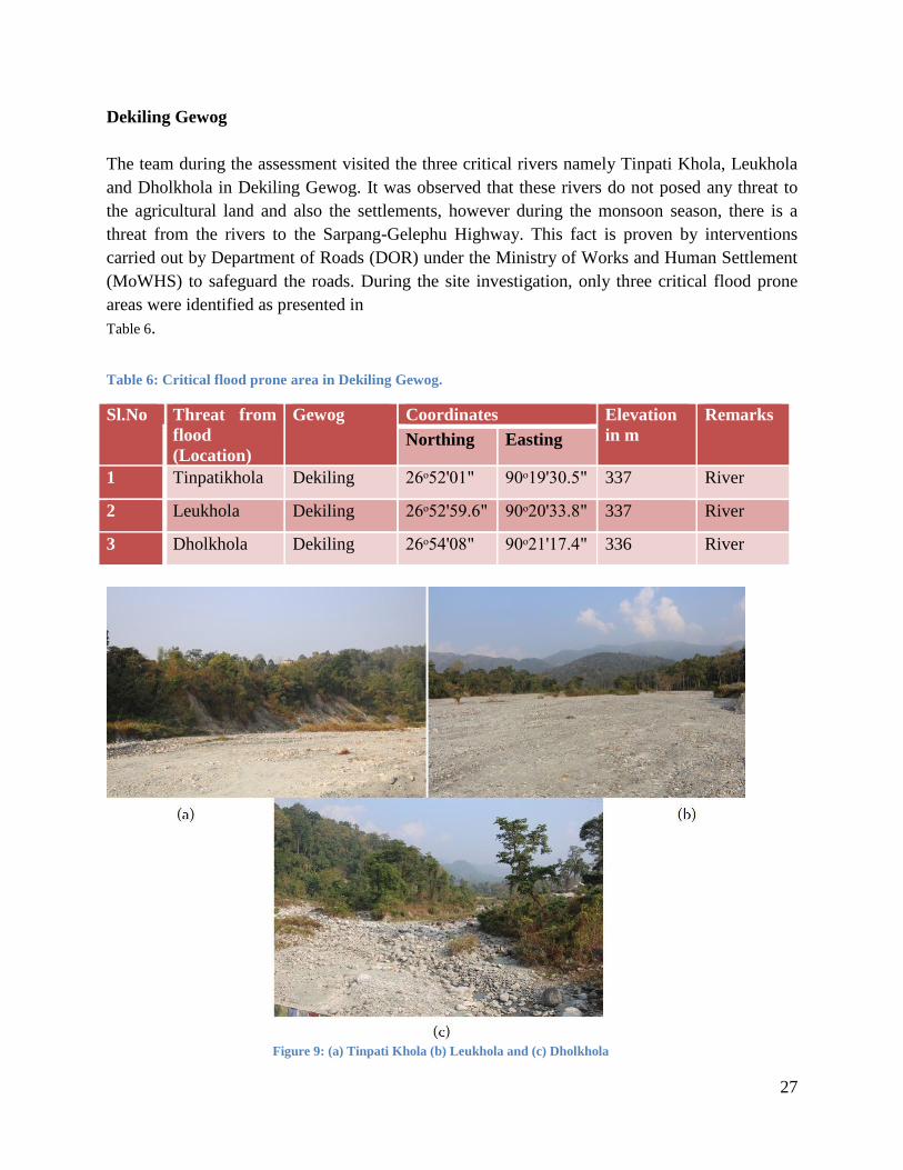
Dekiling Gewog
The team during the assessment visited the three critical rivers namely Tinpati Khola, Leukhola
and Dholkhola in Dekiling Gewog. It was observed that these rivers do not posed any threat to
the agricultural land and also the settlements, however during the monsoon season, there is a
threat from the rivers to the Sarpang-Gelephu Highway. This fact is proven by interventions
carried out by Department of Roads (DOR) under the Ministry of Works and Human Settlement
(MoWHS) to safeguard the roads. During the site investigation, only three critical flood prone
areas were identified as presented in
Table 6.
Table 6: Critical flood prone area in Dekiling Gewog.
Sl.No Threat from
flood
(Location)
Gewog Coordinates Elevation
in m
Remarks
Northing Easting
1 Tinpatikhola Dekiling 26ᵒ52'01" 90ᵒ19'30.5" 337 River
2 Leukhola Dekiling 26ᵒ52'59.6" 90ᵒ20'33.8" 337 River
3 Dholkhola Dekiling 26ᵒ54'08" 90ᵒ21'17.4" 336 River
Figure 9: (a) Tinpati Khola (b) Leukhola and (c) Dholkhola

28
As seen in the Figure 9, the settlements are not located near the rivers,
therefore, there are not so much destructions by the rivers during the rainy seasons. All the three
rivers are seasonal. During the assessment, it has been observed that there is minor scouring
along the river banks of the three rivers. Tinpati Khola and Leukhola are of meandering nature
and lots of forest land has been converted to the flood plains along the rivers.
Samtenling Gewog
In the Samtenling Gewog, there are four rivers namely Bhur Khola, Paithrai Khola, Big Aipoly
and Small Aipoly. Apart from the Bhur Khola, all the other three rivers are seasonal. The site
investigations resulted in identifying four critical areas in Samtenling Gewog as given in
Table 7.
Table 7: Flood prone areas in Samtenling Gewog.
Sl.No Threat from
flood
(Location)
Gewog Coordinates Elevation
in m
Remarks
Northing Easting
1 Bhur Khola Samtenling 26ᵒ55'24.6" 90ᵒ23'55" 337 Left bank
2 Paithrai khola Samtenling 26ᵒ53'40" 90ᵒ26'25.2" 332 Right
bank
3 Big Aipoly Samtenling 26ᵒ54'01.9" 90ᵒ27'23.6" 343
4 Small aipoly Samtenling 26ᵒ52'45.6" 90ᵒ28'22.9" 272
Presently, as per the visual inspection and hearsay during the site investigations, there seems to
be no threat from the Big Aipoly to the settlements and agricultural fields. However, if it changes
is course, the Gelephu Domestic Airport will be under threat from flooding since it flows right
above the airport as shown in Figure 10(a). Likewise, the Bhur Khola also does not pose much
flooding hazard to the settlements and the agricultural fields since it is located far away from the
community. On the contrary, Small Aipoly and Paithrai Khola are the rivers which are prone to
flooding in the Gewog.

29
Figure 10: (a) Big Aipoly and (b) Bhur Khola.
Paithrai Khola in Samtenling Gewog
Figure 11: Threat from the Paithra Khola.
During the site investigation, it has been observed that Paithrai Khola is one of the notorious
rivers posing threat to the settlement and agricultural fields in Samtenling Gewog. This is
confirmed by the fact that Dzongkhag Administration has also carried out interventions in the
past to reduce the vulnerability of community to flooding in Samtenling village as shown in
Figure 11. The past interventions carried out have also failed in some places due to erosive
nature of the river during the rainy season. The river beds are also covered with sediments
implying debris problem in the rivers. From the visual inspection, it can be seen that scouring is
happening along the river banks. Therefore, some more interventions are required to protect both
the settlements and agricultural lands from flooding from Paithrai Khola in the Gewog.

30
Small Aipoly in Samtenling Gewog
The small Aipoly stream during monsoon season always causes the flash flood in and around the
international Check Post at Gelephu making the lives of people living in that locality quite
miserable and even cause damages to the public and private properties. The stream brings in
huge quantities of debris during the rainy season and also keeps on changing its course. The
flood scenario caused by small Aipoly dates back to decades. With the coming up of domestic
airport, flooding situation may have been aggravated as runoff from the airport and surrounding
areas drained off to small Aipoly, thereby increasing the volume. The only solution to prevent
flooding was to divert the small Aipoly stream to the Big Aipoly. However, the diversion work
couldn’t be implemented due to some trans-boundary issues.
Therefore, to reduce the impacts of flooding near the international check post, FEMD
constructed a detention pond with a capacity to store the runoff of 38,100 cum for a certain
period of time as presented in Figure 12. The concept of detention pond was introduced for
Aipoly as a pilot project. The water is to be stored and discharged in a controlled way through
the outlet within the capacity of the storm water drain near the culvert. The detention pond was
designed to be a pool created by excavating the earth below the ground level. The maximum
hydrostatic pressure developed with full capacity would be withstood by the natural ground
without having to reinforce with additional structures other than revetment. Further, a floodway
is also constructed at the downstream of the detention pond to properly discharge the water
retained in the pond to the drain near the international check post.
Figure 12: Detention pond and floodway in Gelephu.

31
Gelephu Gewog
The Gelephu Gewog has five rivers namely Shetikheri, Dowla Khola, Jogi Khola, Lodrai Khola
and Mao River. Except for Mao River being perennial, all other rivers are seasonal flowing only
during the rainy season. During the site visit, eight critical flood hazard areas were identified as
shown in
Table 8. Out of the five rivers, only Shetikher, Mao River and Lodrai Khola cause destructions to
the settlements, agricultural fields and infrastructure during the monsoon season.
Table 8: Flood prone areas in Gelephu Gewog.
Sl.No Threat from
flood (Location)
Gewog Coordinates Elevation
in m
Remarks
Northing Easting
1 Shetikhari Gelephu 26ᵒ53'33.5" 90ᵒ29'54.2" 251 Left bank
2 Dowla khola Gelephu 26ᵒ53'49.6" 90ᵒ30'04.9" 249
3 Jogi Khola Gelephu 26ᵒ54'41" 90ᵒ30'03.7" 269
4 Lodrai Khola Gelephu 26ᵒ55'23.9" 90ᵒ30'16.5" 290
5 Mau Khola Gelephu 26ᵒ54'54.9" 90ᵒ30'31.8" 256 Right Bank
6 Confluence of
Dowla and Mau
khola
Gelephu
26ᵒ59'41.7" 90ᵒ30'10.6" 240 Left bank
7 Confluence of
Shitikhari and
Mau khola
Gelephu 26ᵒ53'37.3" 90ᵒ30'10" 244 Left bank
8 Mau Khola
( infiltration
gallery)
Gelephu 26ᵒ52'49.7" 90ᵒ30'14.2" 255 Left bank
Mao River in Gelephu.
Mao River, over the past many decades, has been eroding both the banks. The Mao River, with
an average flow of just 40 cubic meters per seconds, has developed a very wide channel as seen
from Figure 13. At certain sections, the width of the river channel is as wide as 1,500 meters.
Without immediate attention, these plains are under high risk from the threat of degradation.
During the monsoon period from June till September four gewogs of Sarpang Dzongkhag are
inaccessible due to the Mao River. During the monsoon period the river gets swollen and the
whole area on the left bank is completely cut off, leading to great inconvenience to the entire
population of the four gewogs.

32
Built with a huge cost is the water treatment plant of Gelephu Town, which is located on the
right bank of Mao River. The Mao River Infiltration Gallery which produces 4MLD was
constructed under Danida funding in 2010. There are also other infrastructures like private
houses, private fisheries, Bhutan Olympic committee (BOC) located very close to the right bank.
These infrastructures are in grave risk of being flooded and washed away. Moreover, the left
bank also has been experiencing constant erosion. A few meter width of land is being eroded
every monsoon.
Figure 13 : Mao River in Gelephu with its tributaries.
Shetikheri in Gelephu.
Shetikheri is a tributary of Mao River and it is a seasonal stream. Upon site investigation of the
catchment, numerous landslides were seen. The landslides may be triggered by human activity
such as construction of high tension transmission towers. Further, a road has also been
constructed at the upstream near the source with no proper drainage, this may have also

33
contributed to the increase in runoff and sediment load. The source of the Shetikheri is as shown
in Figure 14.
(a) (b)
Figure 14: (a) Source of Shetikheri (b) Landslide at source.
During heavy rain over an extended period of time, it carries huge volume of debris as given in
Figure 15.
(a) (b)
Figure 15: (a) Scour depth on the pillars (b) Debris collected at the downstream of Shetikheri.
It normally starts to meander along its way causing flooding at various locations downstream. As
per the assessment, there is an erosion of the bank on the upstream portion and thus, the
sediments are transported to the lower plains in the downstream portion of the river during rainy
season. As the sediments are transported to the floodplains, the elevations of the floodplains are
raised and thus, the flow path of the river is reduced. Therefore, the river flows through a new
path during peak season with lower elevation resulting in meandering rivers. The Shetikheri
stream is adjacent to Pelrithang village (Left Bank) and Zomlingthang village (Right Bank) and
encroachment towards these settlements during the monsoon is common due to its meandering
nature. Meandering or change in course is caused mainly due to the deposition of massive
quantity of debris during the flooding.

34
Past interventions for flood protection has also been done by construction gabion walls of height
ranging from 2 to 3 metres at critical points. Further, in order to prevent flooding of the adjacent
villages, channelization/floodway was constructed as given in Figure 16. A floodway of 12m
width was constructed upstream of the culvert on the main highway in the year 2012 with
technical backstopping from FEMD. In the financial year, 2015-2016, floodway of width 20
metres and length 700 metres was awarded to contractor, which was still ongoing at the time of
flooding in July, 2016. Further, during the financial year 2016-2017, gabion walls with apron
have been designed at the identified critical areas by FEMD to reduce the vulnerability of
communities to flooding in Gelephu Gewog.
Figure 16: Past interventions along Shetikheri (Gabion walls and floodways).
Dowla Khola and Jogi Khola in Gelephu.
Both Dowla Khola and Jogi Khola are seasonal and doesn’t pose much danger to Gelephu town.
However, Dowla Khola during rainy season damages the Gelephu- Zhemgang Highway making
it inaccessible to the public. It doesn’t affect the agricultural fields and the settlements. On the
other hand, Jogi Khola affects the settlement and the agricultural fields in and around Gelephu
Gewog since it flows through the settlements as given in Figure 17. If left without any

35
interventions, there is high chance of it changing its course and affecting the settlements in the
Gelephu Thromde.
Figure 17: (a) Dowla Khola and (b) Jogi Khola.
Lodrai Khola in Gelephu.
As per the assessment, the Lodrai Khola does not impact the agricultural fields and settlements
in the Gewog since the Dzongkhag has provided RCC( Reinforced Cement Concrete) flood
protection walls along the right bank of Lodrai. However, the river has eroded the left bank of
Lodrai Khola near the RBA (Royal Bhutan Army) colony at the confluence of Mao River. There
is an urgent requirement of flood protection structures near the colony as seen from Figure 18.
Nevertheless, foundation work for the flood protection works are going on as per our
observations.
Figure 18 : (a) Left Bank and (b) Right Bank.

36
Sershong Gewog.
In the Sershong Gewog, there are three rivers namely Thewar Khola, Masana Khola and
Jangkurung Chhu. In addition to these rivers, the Gewog also is located at the left bank of Mao
River, thereby making it more vulnerable to flooding from the Mao River. The critical flood
prone areas in the Gewog are as given in the Table 9.
Table 9: Flood prone areas in Sershong Gewog.
Sl.No Threat from
flood
(Location)
Gewog Coordinates Elevation
in m
Remarks
Northing Easting
1 Thewar
Khola
Sershong 26ᵒ55'21.1" 90ᵒ31'35.
6"
273 Left bank
2 Masana
Khola
Sershong 26ᵒ54'45.7" 90ᵒ31'07.
7"
259
3 Mao River
Left bank
Sershong 26ᵒ55'39.4" 90ᵒ30'32" 238
Thewar Khola and Masana Khola in Shershong Gewog.
During site investigations, it was found out that both the Thewar Khola and Masana Khola are
seasonal and do not affect the settlements and the agricultural fields at present. However, some
agricultural fields near the rivers are left fallow indicating that minor damages are caused to the
fields nears the rivers. Further, during rainy season both the swollen rivers caused road blockages
since both the rivers pass through the roads as seen in
Figure 19. When the Thewar Khola gets swollen, the connectivity between Shershong village to
Norbuling village in the Shershong Gewog and also connectivity between Shershong Gewog and
Chuzaygang are affected. Similarly, when Masana Khola gets swollen, there are no connectivity
between Shershong Gewog and Chuzaygang Gewog.
(a) (b) Figure 19: (a) Thewar Khola and (B) Masana Khola in Shershong Gewog.

37
Mao River and Jangkurung Chhu in Shershong Gewog.
During the assessment, the team observed the Shershong village located on the left bank of Mao
River is threatened by the Mao River. There are chances of Mao River breaching its bank and
damaging the agricultural fields in Shershong village in future as seen in figure below.
(a) (b)
Figure 20 : (a) Mao River and (b) Jangkurung Chhu.
The team observed that Jangkurung Chhu does not pose much threat to the settlements at present.
However, it has been noticed that a lone house on the right bank of the river is threatened by the
landslides caused by the erosion of the river bank. Therefore, a google image time series analysis
has been carried to see the meandering nature of the stream. It is observed that the river course
changes from time to time as presented in Figure 21.
(a) (b) Figure 21: (a) Flowpath in 2010 (b) Flowpath in 2013.

38
Umling Gewog
In the Umling Gewog, there are only one critical river namely Taklai River. The
Table 10 gives the flood prone areas in Umling Gewog.
Table 10: Flood prone areas in Umling Gewog.
Sl.No Threat from
flood
(Location)
Gewog Coordinates Elevation
in m
Remarks
Northing Easting
1 Taklai Khola Umling 26ᵒ50'34.6" 90ᵒ31'50" 211 Left bank
Taklai Rivers flows through Zamlingthang village under Umling Gewog. Almost 75% of the
paddy field was washed away by flash flood in mid-2016. These areas affected by the flood were
mainly used for agriculture purposes and there were no household. During the site investigations
also, the flooding threat was mainly to the agricultural land used for rice cultivations in the
Gewog. The recent flood in 2016 also resulted in the river bed level reaching almost the same
level as existing ground level as given in Figure 22 and therefore, an appropriate flood protection
structures are required on the left bank of the Taklai River to protect the agricultural field.
Figure 22: Agricultural field on the left bank of Taklai Chhu.
Past Flood Event in The Study Area5
As per the site investigations, it has been learnt that Sarpang Dzongkhag experiences frequent
flooding causing extensive damages to the agricultural fields, infrastructures etc. This is due to
the fact that most of the rivers in the Dzongkhag passes through the settlement. Sarpang Chhu
has temporary structures and agricultural fields along the left and the right banks respectively.
5 Post Flood Report, Department of Engineering Services, MoWHS (August, 2016).

39
Shetikheri, Aipoly and Maochu also flow through settlements and agricultural fields. The
Dzongkhag had experience flooding but don’t have a proper record of the damages caused by the
flood events. The most recent flash flood of July, 2016 in Sarpang caused damages to flood
protection walls, roads, bridge and other infrastructure. The details of the damages caused by the
flood in July, 2016 in Sarpang Dzongkhag are given below.
Sarpang Chhu Flood
Sarpang Dzongkhag experiences heavy rains during summer season every year. The people
living in the Sarpang Bazaar, mostly made up of bamboo houses located on the left bank of
Sarpang Chhu live in fear. As per the local residents, Sarpang town experienced major
devastating flood in the year 1996, which washed away the whole Sarpang Bazaar. Recently, the
flood in July 2016, also caused major damages to the roads, ongoing flood protection structures,
agricultural fields and rendered all the people residing in Sarpang Bazaar homeless as shown in
Figure 23.
Figure 23: Destruction caused by the flood in July, 2016.

40
The recent flood was caused due to continuous rain that lasted for more than a week. Non-stop
rain that started since 14th July led to the swollen Sarpang Chhu which began to change its
course towards the left (Figure 25) from its usual flow along the right bank (Figure 24). The
meandering of the river was caused due to the sedimentation at the low point triggered by the
change in direction upon hitting the huge boulder and RRM wall at the right side of the bridge
abutment. From 21st July morning, the river encroached towards the Sarpang makeshift town
and slowly scoured and carried away the land and the houses. By 25th July, the river had washed
away 480 m of Gelephu-Sarpang-Damphu primary national highway. The river however, didn’t
enter the small island in the midst of Sarpang Chhu which has a Hindu Temple.
Figure 24 : Original river course (along the right bank) before the flooding of July, 2016.

41
Figure 25: Sarpang Chhu changed its course towards the left bank (During Flood).
The estimated damage during the flooding of Sarpang Chhu in 2016 is given in Table 11.
Table 11 : Estimated Damages for Sarpang Chhu Flood Protection Works.
Sl.No Dzongkhag Name of the
Work
Length of
the
Floodway
(KM)
Total
Length
damaged
(KM)
Estimated
damage (Nu)
Remarks
1 Sarpang
River
protection
work along
Sarpang chhu
(Phase-I)
0.4 0.4 10,797,199.54 Construction
was on-going
at the time of
the flood
River
protection
work along
Sarpang chhu
(Phase-II)
0.75 0.75 14,062,542.87 Construction
was on-going
at the time of
the flood
Total Cost Estimates of the Damages 24,859,742.41
(Source: Sarpang Dzongkhag)

42
Mao River in Gelephu Drungkhag
Figure 26: Mao River flowing towards the Infiltration Gallery.
During the flood on 22nd July, 2016 the flood water has entered the infiltration gallery filling it
with huge debris and sediments as seen in
Figure 26. The flood damaged the 500m long spur wall which collapsed resulting in filling up of
the infiltration gallery with debris. It also caused damages to RRM wall. The fencing (MS angle
and MS wire mesh) around the infiltration gallery were also damaged incurring a loss of about
Nu. 0.7 Million.

43
Figure 27: Destructions caused by Mao River near the Infiltration gallery.
The Inner surface of the Infiltration gallery is constructed using gabion walls. The depth of the
infiltration gallery is 13m below the ground. During the flood, although efforts were made to
prevent heavy debris from entering into the infiltration gallery by the Thromde officials with the
help of volunteers, huge amount of silting has been deposited inside the infiltration gallery. This
has resulted in reducing the pump efficiency as well as the quantity of water supply. The
restoration works for the infiltration gallery incurred about Nu.0.4 Million which included the
use of excavators and removing silts deposits from the gallery. Further, the flood also damaged
RRM (Random Rubble Masonry) walls, compound lighting and 2 numbers of submersible
pumps incurring a loss of about 0.9 Million, 0.1 Million and 0.6 Million respectively as given in
Figure 27.
Shetikheri in Gelephu Drungkhag
During the flood in July, 2016, the floodway initially prevented flooding of the settlements near
Shetikheri by restricting the flow through the floodway. However, as soon as it reached the
culvert on the main highway, the flow velocity was reduced as a result of constriction of the
flowpath by the culvert. Then the deposition of the sediment and debris took place as presented
in Figure 28. The deposition of the material near the culvert led to change in course towards the

44
settlement on right bank, damaging the culvert on the right bank in the process. After continuous
deposition on the right bank the river changed its course towards the left affecting the settlement
on the left bank. In this way, lots of settlements were affected and people were evacuated with
their properties to a safe location.
Figure 28: Settlements along Shethikheri affected by the flood.
The flooding also damaged roads, transmission lines and water pipe lines on national highway as
given in Figure 29. The floodway was also damaged and covered with debris. The gabion walls
constructed on the critical areas along Shetikheri was also damaged by the flood of July, 2016.

45
Figure 29: Destructions caused by the Shetikheri stream.
Taklaichu in Umling Gewog.
Figure 30: Damaged wall and affected paddy field locations.
The flood in July, 2016 caused major damages to the agricultural land and minor damages to the
flood protection structures along Taklaichu as presented in Figure 30. It was apparent during the
site visit to the affected area that the debris and sediment from the flooding had severely
submerged some parts of the agricultural land.

46
Figure 31: Paddy field damage location at Gadhen and Linger Village.
With regard to impact of flooding on to the 1000m river training walls that existed just before the
flood, the team was informed by the local representatives that the wall had suffered some minor
damages as a result of floods of 2008 and 2015. Due to shortage of funds, the damaged gabion
walls could not be repaired. And therefore, the recent flood broke through the already damaged
gabion wall which eventually collapsed resulting in free flow of Taklai River towards the paddy
fields, damaging the existing 1000 meter earthen irrigation channel in the process. The earthen
channel also aggravated the flooding by favoring the river flow towards the paddy fields. The
Figure 31 shows the location of the affected paddy field by Taklaichu in 2016. In total, 826
meter of gabion of 4 meter height was completely washed away. The remaining 174 meter
experienced damages to the apron although the wall was still standing at the time of the visit.

47
Jangkurung Chhu in Shershong Gewog
The flood in July, 2016 also causes some minor damages along the river banks of Jangkurung
Chhu as a result of scouring and erosion. The local people informed that there are about 25
households along the right bank of Jangkurung chhu. As per the assessment, there were signs of
fresh scouring and slides along the right bank and one house was found directly exposed to the
risk of flooding as seen in Figure 32. As per the house owner, the recent flood scours the river
bank and created slides, which started to encroach into his land.
Figure 32: Minor landslide and scouring along Jangkurung chu.

48
Rainfall Study for the extreme event in June, 20166
Figure 33: Bhur rainfall events.
Figure 34: Shershong rainfall events.
There are only two rainfall stations in Sarpang which are located in Bhur and I-bridge in
Chisopani in Gelephu. These stations maintain records of daily rainfall in the area. The rainfall
data were compared for different years for the past flood events. The Figure 33 and Figure 34
6Post Flood Report, Department of Engineering Services, MoWHS (August, 2016).

49
illustrates high magnitude of rains received in the month during the past flood events (1996,
2000, 2007, 2008, 2015 and 2016).
From the graph plotted, it is observed that the month of July 2016 received relatively higher
continuous rain in Sarpang and Gelephu indicating the uniqueness of rainfall pattern. Both the
stations recorded continuous daily rainfall of more than 100 mm for more than a week. The
maximum daily rainfall in Bhur and Sershong station were 324 mm and 425 mm respectively.
However, the rainfall recorded during the flood event is less than the annual maximum rainfall
recorded in the previous years as depicted in Figure 35. As illustrated in the Figure 33 and
Figure 34 there has been higher daily rainfall in the past years than the one recorded in July
2016. Therefore, the recent flooding event in Sarpang and Gelephu could be attributed to the
continuous rainfall.
Since rainfall stations locations are not within the catchment area of the flooded rivers, it might
not represent the realistic quantity of rainfall received by the catchments. As seen in the Figure
35, the rainfall quantity in two stations also varies considerably signifying that the data recorded
in these two stations are not enough to analyze the rainfall extremity.
Figure 35: Annual maximum rainfall at Bhur and Shershong.
Identifying Critical River
Based on the extreme past events, threat it poses to the community, investment made for flood
protection works and urgency of situation, Sarpang Chhu and Moa khola has been identified as
critical rivers requiring immediate attention. However, for Mao River our Ministry as the parent

50
agency is drafting proposal to the Dutch Government for technical assistance on “River training
and land reclamation along Moa River.”
The output of the study would be design, drawing and estimate of an appropriate flood protection
structures along Mao River to reduce the vulnerability of communities to flooding. In addition to
this proposal, the Division also has an approved project with the World Bank. This project will
focus on “Flood Hazard Assessment” of the tributaries of Mao River River. This study will
complement the studies proposed to the Dutch Government for the Mao River River. Thus, for
this assessment, Sarpang Chhu flowing through the Sarpang Bazaar has been defined as the
critical river.
River Cross-Section Survey
Figure 36: Sarpang Chhu cross-section survey
Taking cross-section survey of a river channel is important while conducting river analysis to
find the river discharge, velocity, river profile etc. Cross-sections are required to represent
channel geometry in a river hydraulic model. The accuracy of the simulated water levels and the
floodplain delineation largely depends on the shape as well as extent of these cross-sections. For
the assessment, the cross-section data was derived from DEM and also surveying using total
station. The cross-section survey of Sarpang Chhu was carried out by FEMD, DES, MoWHS in
December, 2016 as shown in Figure 36. About 42 numbers of cross-section data were collected
along Sarpang Chhu.

51
Development of Model
Hydrodynamic Model (HEC-RAS)
Sarpang Chhu in Sarpang is ungauged, therefore there was no discharge data for modeling
purpose. The nearest rainfall station is Sarpang “Class C” Station with daily rainfall recorded
from 1996 till July, 2015. However, it closed on July, 2015 and for some years, the data are
missing. Therefore, this rainfall data cannot be used to run rainfall-runoff model to calculate the
discharge of the Sarpang Chhu. The other two stations still maintain records of daily rainfall in
the Dzongkhag but it cannot be used since it does not fall in the Sarpang Chhu catchment.
Therefore, it will not give the realistic spatial distribution of rainfall in the Sarpang Chhu
catchment.
Since there is no rainfall and discharge data for Sarpang Chhu, the discharge of different return
period for Sarpang as calculated by the Lhawang Survey and Design Consultancy, 2013 has been
used to prepare the flood hazard mapping. The discharge data for 25, 50 and 100 year return
period for Sarpang River is obtained from modified Dicken’s method as shown in Table 12.
Return period (yr) Discharge (m3/s)
25 390
50 453
100 515 Table 12: Discharge of different Return period for Sarpang
The surveyed cross-section data could not be used to develop the geometric data since it gave
lots of error while running the river analysis system. In order to utilize collected data for river
modelling in GIS, all data were transformed to a common datum (Drukref 03 Sarpang TM).The
required geometric data for modelling was extracted from the DEM using HEC-GeoRAS, an
extension of ArcGIS as shown in Figure 37.

52
Figure 37: Geometric data used in the River Analysis of Sarpang Chhu.
The RAS Mapper in HEC-RAS 5.0.0 was used in hazard mapping phase to extract water surface
profile data and depth data. The model calibration in HEC-RAS was carried out by assigning the
main input parameters such as flow volume, manning roughness coefficient, channel bed slope,
etc. The probable flooding area was delineated using the water surface data and DEM created for
the catchment. The flood hazard map prepared clearly shows the spatial distribution of the
flooded extent at peak flow which is located at areas with relatively low elevation.

53
Result Analysis and Conclusion
Model output
Figure 38: River Cross-section showing the water level.
River centerline is sketched with the help of given river network from the google earth image.
The river cross-section data used in modeling are obtained from DEM (Digital Elevation Model).
The schematic of geometry in HEC-RAS for Sarpang Chhu are shown in Figure 38. The cross-
section consists of three parts: main channel, left bank and right bank. Manning’s value of about
0.03 is assigned for main stream. As the discharge for certain return period is fixed, steady flow
option is selected. Subcritical flow regime is chosen. Due to the unavailability of other data,
normal depth is assigned as upstream and downstream boundary condition. For the boundary
condition of normal depth, slope of 0.01 is assigned for both the upstream and downstream
condition.
0 50 100 150 200 250 300 350304
306
308
310
312
314
316
318
320
sarpang2 Plan: Plan 01 17-Jul-17
Station (m)
Ele
vatio
n (
m)
Legend
EG PF 3
WS PF 3
Ground
Bank Sta
.03

54
Preliminary flood Hazard Map for different profile
Figure 39: Preliminary flood hazard mapping for different discharges.
The flood maps in Figure 39 show a clear snap shot of the flooding visualization along the river
with elevation levels and areas susceptible to flooding for different scenarios. Generally, high
water depth occur along the main channel and spreads gradually to the flood plains. The
preliminary flood hazard map only identifies the likely areas to be flooded due to extreme
rainfall events and give a mean depth of floodwaters within each region. The maps are based on
the general land characteristics and rainfall pattern over the Sarpang Chhu catchment.
Further, after the preliminary flood map is prepared, the flood map should be validated to
determine the reliability and accuracy of the generated flood hazard maps by comparing the
actual flooding data from the field to the flooding that was generated by the flood model.
55
Recommendation for flood management
Areas of Mitigation Interest (AoMI) are widely stretched under the vast plains of Sarpang
Dzongkhag. Therefore, as per the site investigation, following are the critical locations/ areas to
be prioritized and provided river training works/interventions in order to avert further damages to
public and private infrastructures, agricultural lands and also to avoid loss of lives:
i) Critical areas identified along Sarpang Chhu.
ii) Left bank of Sisty Khola under Gakidling Gewog.
iii) Critical areas along Big and Small Aipoly under Samtenling Gewog.
iv) Critical areas along Mao River and Shetikhari River under Gelephu Gewog.
v) Left bank of Taklai River under Umling Gewog.
The Department of Engineering Services, MoWHS has also outsourced to Consultancy firm, for
Assessment of Flooding Hazards and Development of Climate-Resilient Flood Mitigation
Measures in Shetikhari and Aipoly (Big & Small) Streams under Gelephu through the World
Bank funding. And separate Project, Development to Build (D2B) under Dutch Programe is
carried out on Mao River to identify suitable and sustainable infrastructural flood protection
interventions in order to reduce Gelephu’s vulnerability to flood by the Mao River.
These Projects are intended to bring all-inclusive report and flood mitigation measures that
would immensely abate the flooding problems under Gelephu.

56
Interventions
Past Interventions
Small Aipoly Stream in Gelephu Thromde
Both the construction of the Detention basin and the floodway was ongoing during the flood of
July, 2016. Each structure had suffered some damages during the flood event.
Detention Basin
During the recent flood of July, 2016, the whole of the earthen embankment collapsed due to the
scouring at the exit of the pond caused by the outflow from the hume pipe as given in Figure 41.
This caused flooding at the international check post downstream. The work was still ongoing
during the flood. The physical progress of the work was 80% and the financial progress was 46%
as of 6th July 2016.
(a) (b)
Figure 40: (a) Exit of the detention basin (b) Baffle walls at the entrance.
The estimated damage for the ongoing detention pond is shown in Table 13.
Table 13: Estimated damage for detention pond (Small Aipoly).
Sl.No
Location Damaged structures Estimated
damage
Remarks
1. Detention
Pond, Small
Aipoly,
Gelephu
✓ South-east wall towards the outlet has
collapsed
✓ The humepipe discharge outlet
provisions have been washed away
About 1.00
million
On-going

57
Thromde
✓ The baffle/deflection wall at the
upstream has been submerged by
sand debris
Total Cost Estimates of the Damages 1.0 Million
(Source: Gelephu Thromde)
Floodway
The ongoing floodway construction protected the houses and settlements during the recent flood
as it provided sufficient flow path for the discharge generated after the pond collapsed. The flood
way however got filled up with sediments during the event and scouring of the flood way banks
occurred throughout the entire stretch as given in Figure 41. The physical progress of the work
was 30% and the financial progress was 20% as of 6th July 2016.
Figure 41: Flood damages along small Aipoly.
The estimated damage for the floodway along Aipoly during the floods is as given in
Table 14.

58
Table 14: Estimated Damage for floodway (Small Aipoly).
Sl.No Location Damaged structures Estimated damage Remarks
1. Floodway for
Small Aipoly,
Gelephu
Thromde
✓ Launching apron of
the revetment
✓ Gabion mesh
✓ Backfill materials
washed away
✓ Other stocked
materials washed
away
✓ Floodway filled with
debris
About 1.3 Million On-going
Total Cost Estimates of the Damages 1.3 Million
Gabion revetment
Many different types of interventions have been implemented under the Sarpang Dzongkhag.
Some examples are AB Mattress Flood embankments along Sarpang Chhu, Gabion Floodway
along Shetikhari River and also Cement Concrete walls along Lodrai river etc. Ideally, the
Interventions needs to properly designed.
Design of the structures are required for effective and sustainable flood mitigation and bank
protection of River to protect the lands, properties, human lives and infrastructures along the
bank of the rivers. Sustainability of the flood and bank protection works in the river bed depends
on sound design of the protection works. The protection will establish equilibrium flow regime
and prevent the banks from eroding and overtopping. The design process is as follows:
▪ Interpreting the results of the mathematical model studies and field assessment studies.
▪ Design of river training works according to the type of flooding problem (erosion,
overflow or sediment related problems).
However, due to limited data and modelling challenges, Gabion revetment flood mitigation
measures are found to be more applicable and sustainable to the southern flood plains.

59
The earthen embankments are constructed along the river banks within the flood plains of a river.
The embankments are constructed to confine the river flood water within the cross- section
available between the embankments preventing it from spilling over to the flood plains. This
type of flood protection against flooding has been provided in some flood prone rivers with low
banks in Bhutan. To prevent the erosion of the earthen embankments, it is further protected by
constructing revetments on the riverside of the embankment. When the revetment is constructed
with gabion mattress filled in with stones, it is called gabion revetment. A typical cross section of
a gabion revetment is shown in Figure 42.
Advantages of gabion revetment
• Can be used as path by the pedestrian beside river.
• The construction materials for this type of flood protection structure are easy to transport
and use at site. (Stones, soils and gabion mattresses)
• It can conform to subsidence as it can move with the earth and also dissipate energy from
flowing water.
• Their permeability allows the gabion baskets to drain water easily reducing the pore
pressure.
• They are environmentally friendly (green alternative) and requires no special masonry or
skilled labour to construct it.
Disadvantages of gabion revetment
• Aesthetically not pleasing to sight.
• When the velocity of the streams and rivers are high, the gabion mesh baskets are at risk
of getting torn by the transported boulders or debris.
• The gabion baskets are at risk of being damaged by corrosion if high quality gabion
baskets are not used
• Upon failure of the gabion revetment, the earthen embankment can be easily eroded.

60
Figure 42: Typical cross section of a gabion revetment

61
Limitations
Although the flood hazard map has been prepared for Sarpang Chhu, there are some unavoidable
limitations such as:
✓ The elevation data required for the map was extracted from STRM. A major problem with
using SRTM data for hydrodynamic modelling of a floodplain is that it is not “bare-earth”
and contains information about vegetation and urban areas that block the water movement in
the model.
✓ The reliability of the maps has been affected by the inadequate spatial rainfall data for the
study area. Since there was only one rainfall station in the Sarpang Chhu catchment with
missing data, it was not used for rainfall run-off model.
✓ There is no discharge data for Sarpang Chhu resulting in the use of data from the previous
studies without any validation.
✓ During the study, the Manning’s roughness is considered constant.
✓ The purpose of the flood hazard maps produced in this study is only applicable for flood
prone awareness programs and drafting the flood managing plans. It is not recommended for
any sort administrative zonation purposes since other hazards have not been considered
during the mapping.

62
References
1. Department of Engineering Services, MoWHS, June 2016, Preliminary Flood Hazard
Assessment for Dungsumchu in Samdrupjongkhar Dzongkhag, MoWHS, Thimphu,
Bhutan.
2. Lhawang Survey & Design Consultancy, 2014, Detailed Engineering and Feasibility
study report for Lhamoizingkha & Sarpang flood protection, MoWHS, Thimphu, 70 p.
3. Bhutan Urban Development and Engineering Service, May 2014,Geotechnical Report
Sarpang Township,MoWHS, Thimphu, 125 p.
4. Department of Human Settlement, MoWHS, 2010, Sarpang Structure Plan (2010-2035)
Final Report Volume 01, DHS, MoWHS, Thimphu, 216 p.
5. Department of Human Settlement, MoWHS, 2010, Sarpang Structure Plan (2010-2035)
Final Report Volume 02, DHS, MoWHS, Thimphu, 147 p.
6. Department of Human Settlement, MoWHS, 2010, Shechangthang Local Area Plan
(2010-2035) Final Report Volume 01, DHS, MoWHS, Thimphu, 121 p.
7. National Statistical Bureau, Royal Government of Bhutan, 2011, Annual Dzongkhag
Statistics 2011-Sarpang Dzongkhag Administration, NSB, Thimphu, 63 p.
8. Asian Disaster Preparedness Centre, 2014, Coursework book for Training in Flood Risk
Assessment and Planning of Mitigation Measures, ADPC, Bangkok, Thailand.
9. Engineering Service, Office of Public Works,National Preliminary Flood Risk
Assessment (PFRA), Ireland.
10. Floodplain definition and flood hazard
assessment,http://www.oas.org/CDMp/document/NHP/oea66e/ch08.htm (21st December,
2016)