FIVE Visionary Globe -...
37
FIVE Visionary Globe They marcht not long, when of the arduous Hill They gain the top; where an inameld Flat (In a Field Em’rauld ) powdred ubies fill, Making them think old paradice was That. Heer, in the Ayre a globe (by wondrous skill So fram’d that Thorough Lights) they contemplat, That th’unresisted Eye the Center sees, As plainly as the superficies. —Luis Vaz de Camões, The Lusiads The first-century corpus of global knowledge by Claudius Ptolemy (c. – ) reentered Latin knowledge space as complex transcultural texts tran- scribed and redacted by Arab and Byzantine scholars, as the title Almagest for Ptolemy’s astronomical work indicates.Two versions of the Geography in Byzantium had come from Alexandria via Arabic scholars in Baghdad and Samarkand.¹ Ptolemy’s texts summarized and synthesized oman and Hel- lenistic terrestrial knowledge, offering instructions for calculating and rep- resenting the earth’s spherical form and for recording locations on its sur- face.They were prized equally by Ottoman and Latin enaissance rulers, as much for their antiquity and symbolic authority as for their scientific or practical value.² The full Ptolemaic corpus came to the attention of West- ern scholars at separate moments. The Almagest and the Planisphaerium, describing the earth-centered cosmos and concentric planetary spheres, had been translated into Latin in the twelfth century. A Greek manuscript of the Geography, studied in Byzantium since ,was delivered to the Florentine humanist Pallo Strozzi by Emanuel Chrysoloras in ; a Latin translation by Jacobus Angelus to which he gave the title Cosmographia was available within a decade,and the work circulated rapidly within humanist circles on both sides of the Alps. 102
Transcript of FIVE Visionary Globe -...

FIVE Visionary Globe
They marcht not long, when of the arduous HillThey gain the top; where an inameld Flat(In a Field Em’rauld ) powdred ubies fill,Making them think old paradice was That.Heer, in the Ayre a globe (by wondrous skillSo fram’d that Thorough Lights) they contemplat,That th’unresisted Eye the Center sees,As plainly as the superficies.
—Luis Vaz de Camões, The Lusiads
The first-century corpus of global knowledge by Claudius Ptolemy (c. –) reentered Latin knowledge space as complex transcultural texts tran-scribed and redacted by Arab and Byzantine scholars, as the title Almagestfor Ptolemy’s astronomical work indicates.Two versions of the Geography inByzantium had come from Alexandria via Arabic scholars in Baghdad andSamarkand.¹ Ptolemy’s texts summarized and synthesized oman and Hel-lenistic terrestrial knowledge, offering instructions for calculating and rep-resenting the earth’s spherical form and for recording locations on its sur-face.They were prized equally by Ottoman and Latin enaissance rulers, asmuch for their antiquity and symbolic authority as for their scientific orpractical value.² The full Ptolemaic corpus came to the attention of West-ern scholars at separate moments. The Almagest and the Planisphaerium,describing the earth-centered cosmos and concentric planetary spheres, hadbeen translated into Latin in the twelfth century. A Greek manuscript of theGeography, studied in Byzantium since , was delivered to the Florentinehumanist Pallo Strozzi by Emanuel Chrysoloras in ; a Latin translationby Jacobus Angelus to which he gave the title Cosmographia was availablewithin a decade, and the work circulated rapidly within humanist circles onboth sides of the Alps.
102

Beyond the prestige of an ancient text to be decorated, presented, andpossessed as an item of cultural capital, three specific features of Ptolemy’sGeography helped alter the West’s global image: Ptolemy’s scientific hierar-chy of spatial representation (book ), his methodological descriptions forplotting the sphere on the plane (books and ), and the eight thousandcoordinates for places across the ancient ecumene (books –). From thisgazetteer a set of world and regional maps (tabulae) could be constructed.These graphic images, initially in manuscript form but by the final quarterof the fifteenth century cut and engraved on wood or copper plates for print-ing, offered a visual bridge to the imperial spaces of antiquity. The agencyof print expanded their circulation and speeded the processes of criticismand emendation. The Geography offered a model for the atlas, the mathe-matically coordinated and systematically scaled representation of terrestrialspatiality that connected Western global representation to the book.Whatthe globe illustrated in three dimensions,Ptolemy’s opening map,Typus orbisterrarum (see Fig. .), projected onto two, the controlling image for the sys-tematic spatial subdivision that followed.
Ptolemaic spatial order would be extended in the sixteenth century to athreefold hierarchy. Cosmography represented the totality of a spherical cos-mos, geography provided geometrically exact images of the earth’s sphericalsurface and its major divisions, and chorography pictured the form and char-acter of localized spaces and places. This was a different spatiality from thenavigator’s or the chartmaker’s. Ptolemaic science fitted a theoretically un-limited set of spatial data onto a geometrically predetermined surface. Fit-ting empirical (oceanic) information within the new spatial framework wasa long, critical, and very public process, enabled largely by print culture.³Incunable editions of the Geography were printed in ome, Bologna, Ulm,and Vicenza. By new tabulae, or maps illustrating differences betweenancient and modern geography, were being bound into the text, a processof hybridizing the classical work that opened up the possibility for progres-sive addition of maps showing spaces unknown to the ancients and the ulti-mate erasure of the received world image.⁴ Within a century of its printingthe Geography had become a historical item only, a structural trace in Abra-ham Ortelius’s Theatrum orbis terrarum of and the pedigree of atlases thatfollowed.
But the Ptolemaic contribution to an Apollonian imperial discourse ofglobal sovereignty in the early modern West and its implications for con-ceptions of a global humanity were vital. Through the graticule, globalismemerged as a conception that connected discourses of humanity and civi-
V I S I O N A R Y G L O B E 103

lization. In the maritime and intellectual centers of Europe, Abraham Or-telius, Gerard Mercator, and Jodocus Hondius followed earlier cosmogra-phers—Martin Waldseemüller, Oronce Fine, Peter Apian, and others—inelaborating ways of picturing a habitable earth, not a restricted ecumene, bymeans of illustrated globes and atlases.These pictured in detail a great the-ater of the world wherein dreams of Christian redemption,global imperium,and a singular humanity might be projected and rhetorically secured.
Ptolemaic Perspective
The figure of Claudius Ptolemy is widely represented in art of the late Mid-dle Ages and the enaissance, grasping the armillary sphere or astrolabe thatrepresents the cosmic scope of his work. He is clothed as an Arab or orien-tal seer, not uncommonly a magus, frequently sharing the iconography ofthe Wise Men, whose cosmographic skills foretold the birth of the Christ-Apollo (Fig. .).⁵ His Almagest catalogued , visible stars and twenty-one constellations, and its calculation of planetary movements was theempirical foundation for astrology, connecting the Alexandrian astronomerto ancient Egyptian esotericism. The most striking feature of the carvedwood Ptolemy in the choir stalls at Ulm, the location for an early printingof the Geography, is his narrowed eyes staring intently at the armillary sphere.The astronomer’s vision extends over space and time. While the marinerscans the horizon and interrogates the compass, the astronomer’s vision risesconceptually over the surface, escaping the contingencies of location andmoment in order to grasp a cosmic order and regularity.The cosmographiclanguage is geometry, in the view of Platonizing enaissance cosmographersthe divine language of creation.⁶
This conceptual capacity to grasp the earthly sphere from a cosmic loca-tion is essential to Ptolemaic mapping. In the Almagest Ptolemy details con-structional techniques for making a celestial globe, emphasizing its value indisplaying the heavens to the eye.⁷ The Geography is driven by the idea ofrendering visible the form and pattern of the earthly sphere. Geographyis founded on geometry,“the art of delineating solid objects upon a planesurface so that the drawing produces the same impression of apparent rela-tive positions and magnitudes, or of distance, as do the actual objects whenviewed from a particular point.” Geographical science draws on geometryto make “an imitation and description of the whole of the known world andall the things which are almost universally related to it.”⁸ The globe is bestrepresented by a graticule of lines of longitude converging at the poles
104 A P O L L O ’ S E Y E

and degrees of parallel latitudinal lines measured from the equator. Co-ordinating these numbered lines allows point location to be precisely deter-mined on the conceptual surface. The implications of representing earthspace through an infinite array of fixed points are more than merely instru-mental. The graticule flattens and equalizes as it universalizes space, privi-leging no specific point and allowing a frictionless extension of the spatialplot. At the same time it territorializes locations by fixing their relative posi-
V I S I O N A R Y G L O B E 105
5.1. Claudius Ptolemy examines the heavens and the terrestrial globe in a fifteenth-century manuscript
copy of the Geography. Photograph from Bibliothèque nationale de France, Paris.
Image not available.

tions across a uniformly scaled surface. Its geometry is centric only at thepoles, which, practically speaking, are the least accessible points on its sur-face; otherwise it extends a nonhierarchic net across the sphere. Geometricprojection allows the spherical surface to be transformed and molded on theplane while retaining consistency of locational relationships. What DavidWoodward has called the route-enhancing properties of the portolano andthe center-enhancing structure of a Jerusalem-centered mappa mundi aredisplaced in favor of the space-equalizing and area-fixing properties of thegraticule.⁹
Ptolemy offers four techniques for transforming the sphere into a two-dimensional surface,each involving areal and directional distortion.The sim-plest inscribes parallels and meridians as a rectangular grid, rapidly distortingshape and scale as one moves away from the equator.Two “conic” transfor-mations seek to accommodate spherical curvature, one by radiating straightmeridians from the poles to the equator across curving parallels, the otherby maintaining a straight central meridian while progressively curving thelongitudinal lines to its right and left, thereby maintaining their true posi-tion at both pole and equator and giving a visual impression of sphericity.In book Ptolemy describes a fourth alternative, placing the observer’s eyeat a position where the visual axis is in a latitudinal plane; the earth is seenfrontally, and mathematical calculations are made from a distance point lo-cated within the sphere. Ptolemy effectively represents the earth as a trans-parent sphere, similar to the astronomer’s hand-held armillary. While thisfourth “projection” cannot be produced mathematically, unlike the stereo-graphic projection described in Ptolemy’s Planisphaerium, it conjures an imageof how the earth might look from space—the Apollonian perspective.Theclose historical and cultural affinities between the reappearance and dissem-ination of Ptolemy’s fourth model and the pictorial method of linear per-spective demonstrated by Filippo Brunelleschi in and theorized byLeon Battista Alberti a decade later have been widely remarked.¹⁰ epre-sentational space was subjected to the conceptual logic of ocular vision inthe opening years of the West’s historic encounter with transoceanic globalspace. Given the increased mobility of reproduced images promoted bymovable type,printmaking, and small-scale oil painting on canvas, the imag-inative and intellectual possibilities opened up by Ptolemaic mapping wereconsiderable. It entered and enhanced a culture in which visual images ofterrestrial, architectural, and natural spaces at a variety of scales circulatedwidely.¹¹
Ptolemy’s graticule covers degrees, and his transformations can gen-
106 A P O L L O ’ S E Y E

erate flat maps of the sphere. But the specific locations coordinated in histext are limited to the classical ecumene. Conical sections easily accommo-date this curving rectangle, largely confined to the Northern Hemisphere.Ptolemy’s text thus confirmed the continental image on Macrobian mapswhile more precisely elaborating it.¹² It described the same coasts as por-tolanos did, reinforcing a sense of an unmediated inheritance of classical em-pire, while the graticule offered the flexibility of assimilating and integrat-ing ancient authority with empirical discovery.Thus Giovanni Leardo’s andFra Mauro’s mid-fifteenth-century circular mappae mundi combine Ptole-maic and maritime modes of representing global space.For the scholars whointroduced the Geography to the West, and for those who financed transla-tions and reproductions of its text and maps—the Medici in Florence, theMontefeltri in Urbino, the Este in Ferrara, Aeneas Silvius Piccolomini(Pope Pius II) in ome, and Mehmed II in Istanbul—accommodating newknowledge into its picture of the earth was not a primary concern. Its imageof ecumenical space assumed significance in the context of other ancienttexts and of competing claims to the imperial inheritance of ome morethan that of oceanic navigation. As the Greek scholar Trepuzuntios put it toMehmed II,“You are the emperor of the omans.Whoever holds by rightthe centre of the Empire is Emperor and the centre of the Empire is Con-stantinople.”¹³ Ptolemy’s tabulae demonstrated such claims graphically.To addnew maps that covered areas unknown to the ancients and to “correct”errors in the Geography’s image of the ecumene (proclaimed as the victoryof experience over authority) reflected an intense geopolitical and moraldebate over the patrimony of classical empire in a modern world.
Like manuscript copies of the Geography, incunable editions were lavishlyilluminated and dedicated to competitively acquisitive patrons. In the six-teenth century, the number of editions and commentaries rapidly increasedas it was translated into Italian and German and became a standard librarywork. The Greek manuscript from which Chrysoloras and d’Angelo hadworked, together with an illustrated copy of their Latin translation, wassecured by Duke Federigo da Montefeltro at Urbino, part of a collec-tion of more than eighteen hundred classical manuscripts.¹⁴Vitruvian archi-tectural proportion and geometry are the governing spatial principles ofFederigo’s palace at Urbino and its managed views over ducal territory.Thesumptuous decoration of the bound manuscript of the Geography closelymirrors that of the palace. Like Ambrogio Lorenzetti’s fourteenth-centurydisk map at Siena, Federigo’s Geography is more than simply an item of cul-tural capital; its images of terrestrial space participate in a cosmographic
V I S I O N A R Y G L O B E 107

rhetoric connecting Montefeltro’s tiny territory across time to the classicalempire and across space to the great orb itself.¹⁵ The imperial conceit is pur-sued in the marginal decoration, which includes Federigo’s stemma inter-twined with portraits of oman emperors and set against the landscape ofthe Italian Marches, over which the duke actually ruled.The decoration ofthis codex is especially extravagant, but printed editions of the Geographywere similarly lavish, testimony to the Geography’s cultural significance in aenaissance visual discourse of territorial authority.
In a poetic rendering of the Geography was dedicated to Federigo.The work, by the Florentine Francesco Berlinghieri (–), offers aninsight into the cultural context into which the Ptolemaic perspective onthe globe was precipitated.Berlinghieri, trained in Greek,rhetoric,and poet-ics, pursued his humanist career as an orator at the Este court in Mantua andlater at Lorenzo di Medici’s Florentine court.¹⁶ He was a member of thegroup that gathered around the Greek scholar and Platonist Marsilio Ficino,with whom Berlinghieri debated Ptolemy’s intellectual significance.¹⁷ Ficino’sown Latin translation and commentary on Plato’s works, to which Ber-linghieri contributed financially, was a defining achievement of enaissancehumanism, a task interrupted briefly in by Lorenzo’s demand that Fi-cino translate Hermes Trismegistus’s writings, supposedly the pre-Mosaicteachings of an Egyptian priest,philosopher,and king.¹⁸ Berlinghieri’s poeticrendering of Ptolemy’s Geography was begun in , making it preciselycontemporary with Ficino’s work. It was prepared in two huge, magnifi-
cently decorated codices, and the printed edition by the German NicolausLaurentii was illustrated with copper engraved maps.¹⁹ The dedicatory lines,composed by Marsilio Ficino himself, make explicit reference to the Her-metic theme of spiritual ascension through the spheres. In this context Ber-linghieri’s poetic rendering of the Apollonian perspective and its elegantvisual realization in copper engraving clothe Ptolemy’s Geography in the quasi-spiritual habits of Ficinian philosophy. The dedication to Federigo in theprinted edition links this Platonic embrace of the sphere to the more secu-lar conceit of imperial subjection of the globe.
This Neoplatonic rendering of the Geography into Dantean verse waspublished in as Septe giornate della geografia di Francesco Berlinghieri Fio-rentino, a title suggestive of the Creation narrative in Genesis. Berlinghierifollows the structure of Ptolemy’s text but incorporates commentaries onhumanist themes such as the mythical and poetic origins of classical places,producing a book that is more philological than scientific. In book , a longdilation on ancient Egyptian burial and other sacred rituals draws upon
108 A P O L L O ’ S E Y E

Strabo, Pliny, and other ancient sources as well as on medieval texts, con-temporary nautical maps, and chorographies of Britain, France, Spain, Italy,and the Holy Land, implying that Ptolemy offers a foundation for cosmo-graphic knowledge.Berlinghieri draws upon Buondelmonti’s Liber insularumarchipelagi,²⁰ whose author was familiar to the Florentine circle as the dis-coverer of Horapollo’s Hieroglyphica, the foundational text on Egyptian hiero-glyphics as the original universal language.²¹ Appropriately, therefore, Ber-linghieri’s opening paean to geography places its study at the heart of alllearning:“How many [disciplines] are affected by the delay of this great work,which takes into full view the whole earth. It feeds not only military art butalso philosophy, scripture, history, and poetry.The sweet life of agriculture,medicine, and art that animates the love of nature in the human breast. Insum, no greater need have our faculties than knowledge of the earth.”²²
Ptolemy is the “light and ample glory of the world” who “raises us abovethe limits of an earth obscured by clouds, which hide our view of the sur-face.” Berlinghieri appeals directly to Apollo and the angelic choirs to raisehis poetic imagination to the task of presenting the whole universe to themarveling human eye. His song will follow Apollo’s curving path over theearth to offer a conspectus, a vision of its surface, without yielding to thetemptation of Icarus. His achievement betrays the imaginative power ofgeography, which permits an intellectual vision of the globe:“It offers divineintellect to human ingenuity, as if it were by nature celestial, demonstratinghow with true discipline, we can leap up within ourselves, without the aidof wings, so that we may view the earth through an image marked on aparchment. Its truth and greatness declared, we may circle all or part of it,pilgrims through the colors of a flat parchment, around which the heavensand the stars revolve.”²³ Imaginative vision across celestial space was a com-monplace of the Ficinian discourse. The ascent of the soul through thestages of sensual, emotional, and intellectual love, corresponding to the ter-restrial, celestial, and supercelestial realms of the Ptolemaic cosmos, respec-tively, was achieved by spiritual purification and contemplation. Its ultimateattainment, a beatific vision of universal love, was a key theme in Ficino’sattempted synthesis of Hellenistic philosophy and Christian theology. Ber-linghieri’s “human genius,” “divine intellect,” and “rising up within our-selves” echo the language of the prisca theologia, the supposed pre-Mosaicanticipation of the Christ-Apollo’s global redemption and renewal.²⁴ Therecovery of the Ptolemaic perspective restimulated the poetic associationbetween global vision and Apollonian ascent.
The actual itinerary that Berlinghieri constructs across the Ptolemaic ecu-
V I S I O N A R Y G L O B E 109
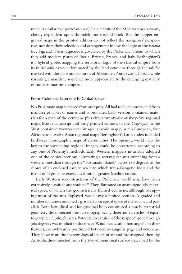
mene is similar to a portolano periplus, a circuit of the Mediterranean coasts,closely dependent upon Buondelmonti’s island book. But the copper en-graved maps in the printed edition do not reflect the navigators’ perspec-tive, nor does their selection and arrangement follow the logic of the isolario(see Fig..).Their sequence is governed by the Ptolemaic tabulae, to whichthey add modern plates of Iberia, Britain, France, and Italy. Berlinghieri’sis a hybrid globe, mapping the territorial logic of the classical empire fromits initial orbis terrarum dominated by the land ecumene through the tabulaemarked with the altars and columns of Alexander,Pompey,and Caesar,whilenarrating a maritime sequence more appropriate to the emerging spatialityof modern maritime empire.
From Ptolemaic Ecumene to Global Space
No Ptolemaic map survived from antiquity. All had to be reconstructed frommanuscript tables of names and coordinates. Each version contained mate-rials for a map of the ecumene plus either twenty-six or sixty-five regionalmaps. Most manuscript and early printed editions of the Geography in theWest contained twenty-seven images: a world map plus ten European, fourAfrican,and twelve Asian regional maps.Berlinghieri’s Latin codex includedbird’s-eye chorographic maps of eleven cities.The opening world map, thekey to the succeeding regional images, could be constructed according toany one of Ptolemy’s methods. Early Western mappers invariably adoptedone of the conical sections, illustrating a rectangular area stretching from awestern meridian through the “Fortunate Islands” across degrees to theshores of an enclosed eastern sea into which trans-Gangetic India and theisland of Taprobane extend as if into a greater Mediterranean.
Early Western reconstructions of the Ptolemaic world map have beenextensively classified and studied.²⁵They illustrated an unambiguously spher-ical space, of which the geometrically framed ecumene, although occupy-ing most of the area displayed, was clearly a limited section. A graded andnumbered frame contained a gridded conceptual space of meridians and par-allels. Both latitudinal and longitudinal lines constituted a purely terrestrialgeometry disconnected from cosmographically determined circles of equa-tor, tropic,ecliptic,climates.Potential expansion of the mapped space through degrees was implicit in the image.Wind heads, still often angelic in theirfeatures, are awkwardly positioned between rectangular page and ecumene.They blow from the meteorological spaces of air and fire assigned them byAristotle, disconnected from the two-dimensional surface described by the
110 A P O L L O ’ S E Y E

graticule, their gaze mirroring that of the human spectator. Framing, shape,and measure rather than the pattern of lands and seas are novel. Thus theworld map in Nicolaus Germanus’s Ulm edition of the Geography quitedramatically diminishes the space of Ocean, presenting a land-dominatedworld.²⁶ Ptolemy’s African east coast extended degrees below the equa-tor, necessitating a corresponding Atlantic coastline, currently the object ofPortuguese navigation. Nicolaus extends Africa westward from the “Gulf ofHesperus” into oceanic space and eastward to connect with Asia, throughterra incognita secundum Ptolemeum, reinforcing the graphic argument on allearly Ptolemaic maps of a land-dominated global surface.
The distinction between Ptolemaic and oceanic images is epistemologi-cal rather than consistently representational. The former assumed a retro-spective spatiality of territorial empire easily appropriated to the Medi-terranean geopolitical context after and reinforced by its incidentalcontents of classical triumphs, columns, and altars.Both genres still pepperedthe spaces beyond the ecumene with anthropophagi and ichthyophagi andother inherited “marvels” and “monsters.” From their first appearance,how-ever,Ptolemaic and oceanic perspectives were brought into dialogue in shap-ing Western globalism. This is apparent, for example, in the form of coastson the maps accompanying Berlinghieri’s text.They reveal the typical scal-loped form of island-book maps. And the frame of the Ptolemaic ecumenewas immediately placed under pressure from oceanic knowledge, literallyapparent in Nicolaus Germanus’s Ulm world map, where, at the northwestcorner of the ecumene, the north parallel breaks to incorporate themare glaciale, the Scandinavian lands and various north Atlantic islands. By, cosmographers such as Martin Waldseemüller could locate oceanicknowledge within the Ptolemaic conceptual frame and challenge its terri-torial emphasis, although the addition of a distinct carta marina endured insixteenth-century editions of the Geography alongside a world map on a pro-jected graticule until Gerardus Mercator’s graphic marriage of the twospatialities.
Fusion of the territorial and oceanic perspectives was a northern Euro-pean rather than a Mediterranean achievement, as was the introduction ofthe new cosmography to a wide reading public. By the Grüningerworkshop in Strasbourg was reproducing large-scale woodcut maps in sig-nificant numbers; it printed five editions of Waldseemüller’s Cosmographiaintroductio between and and two Ptolemy editions in and.²⁷ Lorenz Fries’s German-language edition of the Geography, basedon Angelus’s Latin translation and using Waldseemüller’s maps, competed
V I S I O N A R Y G L O B E 111

with Waldseemüller’s text as an accessible guide to cosmography. It was ac-companied by fifty folded maps and a twelve-sheet carta marina, the first in-dexed world map in a vernacular language. Although it explained how tocoordinate a projection, Fries’s map was not itself a projection; it reducedthe known oceanic space, reinforcing the image of a Mediterranean-cen-tered terrestrial world. In Nuremberg, where egiomontanus’s mathemati-cal legacy combined with the patrician humanism of Willibald Pirckheimer’scircle, interest in Ptolemy was part of a broader cultural interest in space andits representation, facilitated by the exchange of letters, books, and instru-ments between European centers, from navigators in Lisbon to Copernicusin Frauenburg.“Inquire into the hidden and powerful workings of the earth,”proclaimed Pirckheimer, a translator of Ptolemy whose study of Germanplace names, Germaniae explicatio, appeared in .²⁸ The planetary spacesof the cosmos and the territorial spaces of painted landscape concerned thisgroup as much as the oceanic space of navigation, although like those Vene-tians who saw in the Aztec capital,Tenochtitlan, a New World reflection oftheir own city, Nurembergers imagined a mirror of their own city at efu-gio,on the New England coast.²⁹ Pirckheimer’s close friend Albrecht Dürer,who contributed along with Michael Wöhlgemut and Wilhelm Pleyden-wurff to Hartmann Schedel’s Liber chronicarum, in designed a widely re-produced globe woodcut illustrating Ptolemy’s fourth projection,while Nu-remberg merchants commissioned the instrument makers Martin Behaimand Johann Schöner to produce some of the earliest terrestrial globes.Along-side his advanced mathematical texts, Peter Apian published the popularcosmographic handbook Cosmographicus liber in , the first to distinguishand illustrate cosmography, geography, and chorography, whose clear de-scriptions and cleverly inserted vovelles allowed ordinary readers to under-stand the calendrical and seasonal implications of planetary motion and aspherical earth.³⁰ The Latin work was translated into French,Flemish, Span-ish, and Italian, and it was revised and republished into the s.³¹
In northern Europe,Ptolemaic science entered a context of intense moraland theological as well as commercial debate. Ottoman expansion into thelower Danube and the Lutheran challenge to ome cast the idea of a Chris-tian ecumene in serious doubt.The simple, uncompromising black lines ofGerman woodcut prints are less seductive as images of global harmony thanlavish courtly images of Italy and Iberia. Lutherans saw the Ottoman ex-pansion as divine judgment on a corrupt Christendom;some responded witha quietist and familist idea of concord that in some respects paralleled Cath-olic Neoplatonism in Italy.³² The cordiform map projection, pioneered by
112 A P O L L O ’ S E Y E

Oronce Fine for François I of France in and printed for the first timeby Apian as Tabula orbis cogniti in , would become a specific object ofcontemplation among northern familists, its heart shape signifying a worldruled by love in an age of intensifying doctrinal hate.³³
Gerardus Mercator’s mathematical resolution of oceanic and Ptolemaicimages by means of a cylindrical projection, which retained the Ptolemaicgrid’s geographical coordinates while incorporating the mariner’s loxo-dromes, has been criticized as a Eurocentric image, enlarging the temperateregions at the expense of the tropical regions of European imperial expan-sion. At the time of its making the map diminished the areal significance ofEurope, and its relations with empire are subtle. Blending the practical, sur-face spatiality of the navigator with the conceptual, Apollonian eye of Ptole-maic mapping, Mercator’s world map offered a graphic solution to the six-teenth century’s growing tension between textual authority and empiricalevidence as foundations of secure knowledge. At the same time, Mercator’sprofound interest in hermeticism, the power of terrestrial magnetism, andPythagorean metaphysics, apparent in his Typus vel symbolum universitatis,suggests that for Mercator resolving different modes of vision through themathematics of spherical projection was as much a spiritual as a geopoliti-cal act.³⁴
Certainly, the technical combination of oceanic and Ptolemaic visionsdepended on the capacity to think globally, to break the frame of the clas-sical ecumene and imagine the world as a spherical surface.This epistemo-logical break owed more to Ptolemy’s textual descriptions of a sphericalearth within a mathematically structured cosmos and its subjection to geo-metrical manipulation than to Ptolemaic maps.³⁵ As the Geography circu-lated in Europe’s courts, terrestrial globes began to be constructed.The ear-liest extant example is Martin Behaim’s Erdapfel of , commissioned byNuremberg merchants the previous year, although a Vienna-Klosterneuburgmanuscript of the s refers to the manufacture of spherical world maps,and in Guillaume Hobit, astronomer to the duke of Burgundy, con-structed a “round world map in the form of an apple” based on Ptolemy’sdescription. In Pope Sixtus IV obtained from the Ptolemaic mapmakerNicolaus Germanus a terrestrial and a celestial globe for the new VaticanLibrary.³⁶ Bramante’s Heraclitus and Democritus, dating from the same years asBehaim’s commission, clearly intends to show a spherical earth. These ex-amples all point to a widespread interest in the fifteenth century in repre-senting a spherical earth.
The Magellan circumnavigation prompted an explosion of globe mak-
V I S I O N A R Y G L O B E 113

ing, both engraved metallic spheres and, more commonly, printed gores at-tached to wooden globes. Globes now became essential instruments forpolitical strategy, academic study, and trade, if not practical navigation. Asso-ciation with the spherical globe signified the social, intellectual, and moralstatus of “a man of vision” in the sixteenth century. One of the two tapes-tries called The Spheres, a set commissioned by João III of Portugal in thes, shows “Earth under the protection of Jupiter and Juno”: the Por-tuguese sovereigns gesture toward a terrestrial globe, contained by the grati-cule, the Mediterranean ecumene entirely diminished in scale by the spacesof Portuguese navigation (Fig. .). In Holbein’s Ambassadors globes accom-pany an array of astronomical and navigational instruments that underlinethe moral stature of the Frenchmen de Dinteville and de Selve, signal theauthority and fortune of England’s Henry VIII, and respond to Pirckheimer’sinjunction to “Inquire into the hidden and powerful workings of the earth.”³⁷
Ptolemy’s graticule, so emphatically represented in these images, allowsspaces to be “envisioned” before they are encountered and tied logically intouniform global space. Globes and manuscript maps were the means ofachieving this. In the late s Henricus Martellus extended Ptolemy’s -degree ecumene by nearly degrees of longitude;in his Cosmographia Mar-tin Waldseemüller pushed it to degrees. By a “whole-earth” mapcovering degrees of latitude and extending to both poles had been con-structed by Francesco oselli,“drawn on an oval projection into which everypoint on earth could be theoretically plotted and on which every potentialroute for exploration could be shown.”³⁸
The Cosmographic Globe
The Apollonian gaze assumed by Behaim’s globe,oselli’s map,and João III’stapestry is a powerful theme in sixteenth-century art and literature. Cos-mography became the discourse that brought together celestial and geo-graphic exploration, represented space and scale, and theorized the place ofhumans within nature.³⁹ This globalism was underscored by moral pressuresresulting from both reformation and discovery to bring within a single intel-lectual frame the emerging enaissance sense of the sovereign individual, sopowerfully explored in Dürer’s self-portraits, and an expanding world ofhumanity.⁴⁰ This required simultaneously engaging with the globe’s materi-ality and rising above it into the celestial spaces of imaginative vision. InBernard van Orley’s Spheres image sun,moon,planets, and stars have no log-ical location other than that determined by design considerations.Their disks
114 A P O L L O ’ S E Y E

5.2. The imperial globe presented and protected by the Portuguese monarchs, as Jupiter and Juno.
Tapestry by Bernard van Orley, “Earth under the protection of Jupiter and Juno.” © Patrimonio
Nacional, Madrid.
Image not available.

are subordinated to a dominating global sphere, to which the Portuguesemonarchs gesture, at once recognizable individuals and personifications ofJupiter and Juno.They share the firmament with angelic wind heads at themargins of celestial space.The image contrasts with the cosmos in HartmanSchedel’s Liber chronicarum, an encyclopedia,bestiary, and wonder bookcombined, published in Nuremberg, in which a seated patriarchal God ac-companied by fixed ranks of angels and saints oversees a tightly bound cos-mos whose central earth with its continents is the merest button (see Fig..).⁴¹ The Chronicle fits its geography into a Christianized cosmographicnarrative divided into seven ages, an amalgam of biblical and classical learn-ing. The image of the cosmos succeeds six woodcuts illustrating the Cre-ation and is followed by a simplified Ptolemaic ecumene and a chorographyof Eden.⁴² There follow a synopsis of biblical history, lives of the saints, talesfrom Homer,Ovid, and other classical writers, a geographical description ofthe parts of the earth, and illustrations of its cities.The sixth, or current, ageis followed by blank pages, to be filled in the immediate future, before theseventh age, which describes the Apocalypse, judgment, and the dance ofdeath. It is this linear and hierarchical cosmography that van Orley’s global-ism unconsciously subverts.
Schedel’s terrestrial globe is firmly contained within the enclosing spheresof a greater cosmos (although his brief reference to Martin Behaim’s “dis-covery” of islands in the Ocean Sea indicates Nuremberg’s close contactswith Iberian events).The noncentric arrangement of supercelestial and tem-poral spheres illustrates the Aristotelian separation of incorruptible,“simple”heavens from the corruptible, “composed” earth. South of the Alps, theThomist conviction that no direct interaction was possible between thesespheres was under challenge from Platonic thinkers who emphasized the phil-osophic implications of spherical harmony and universal unity. Sixteenth-century cosmographic images such as van Orley’s reflect a simultaneous ero-sion of physical and metaphysical boundaries upon and between globes, thephilosophical legacy of thinkers from the previous century, such as MarsilioFicino and Nicholas of Cusa (–). Cusanus (his humanist name), whohad been a student at Heidelberg and Padua, would play a key role in thoseattempts to reunify Christianity before the fall of Byzantium, which hadbrought Greek and Latin scholarship into such close contact.⁴³ A key figurein the Platonic critique of scholastic Aristotelianism,Cusanus was also closelyinvolved with Ptolemaic science, purchasing cartographic materials fromthe Klosterneuburg monastery in , discussing with German scholars atome in possible new tabulae to supplement the Geography, and pro-
116 A P O L L O ’ S E Y E

ducing his own map of central Europe,the source for that in Schedel’s Chron-icle.⁴⁴ Cusanus was a global thinker, both theoretically and practically, whosedriving belief was unity. Spherical geometry offered him intellectual evi-dence of divinity, “propounding the idea of an infinitely open universe,whose center was everywhere and whose circumference nowhere. As an in-finite being, God transcended all limits and overcame every opposition. Asthe diameter of a circle [or sphere] increased, its curvature diminished; so atits limit its circumference became a straight line of infinite length. Likewise,in God all opposites coincide . . . in the universe God is both centre and cir-cumference.”⁴⁵
Cusanus was equally committed to the unification of faiths and peoples,proposing “a comprehensive vision of all reality,God, the world and man.”⁴⁶
Developing the Majorcan amon Lull’s argument that Christ’s incarna-tion was necessary to unite divine and human natures and based on his ownknowledge of Greek sources, Cusanus published De docta ignorantia in .According to Cusanus, Christ is the necessary union between the cosmicspheres, which Thomism had seen as unable to communicate. ConsultingTimaeus in the original Greek rather than its Macrobian Latin summary,Cusanus argued for a created world animated by divine love, whose expres-sion is optical geometry.The subcelestial realm moves toward a perfect orderof the supercelestial sphere,which may itself therefore be imag(in)ed throughvisual observations received by the globe of the human eye from the mate-rial cosmos.⁴⁷ Cusanus lectured on optics at Padua, where one of his stu-dents was Paolo dal Pozzo Toscanelli, who later corresponded with Colum-bus about the size of the globe. Cusanus’s thinking gave an almost divinesignificance to the sun as the source of light, reinforcing the imaginative ap-peal of the Christ-Apollo, an indirect stimulus to Copernicanism, whoseauthor had also studied at Padua.⁴⁸ Cusanus’s surveying and mapping con-cerns complement his interest in spherical geometry and optics, as well ashis interest in Christendom’s geopolitics. In the aftermath of he evenflirted with the idea that Mehmed II might be the agent of global religiousand political unity.⁴⁹
Among the theological implications of Cusanus’s work was a renewedand distinctive emphasis on the medieval motif of the human microcosm,connecting it to the Platonic ascent of the soul, uniting the individual andthe cosmos. For Cusanus,“man is a microcosm not because he comprises inhimself all the different degrees of reality and thus is subject to all its con-flicting forces, but rather because—situated at the centre of creation, at thehorizon of time and eternity—he unites in himself the lowest level of intel-
V I S I O N A R Y G L O B E 117

lectual reality and the highest reach of sensible nature and is thus a bondwhich holds creation together.”⁵⁰ Cusanus offers a mapping conception ofthe microcosm: the human individual is literally relocated at the center ofthe cosmos, capable of rising imaginatively and spiritually above the globeas an eyewitness to the beauty and harmony of creation. Physical light con-nects the spheres of earth and eye within a spherical cosmos,while the divineillumination of universal love is its metaphysical equivalent. Imaginativemapping of the human individual within the cosmos was an insistent themeamong Ficino’s Florentine group. According to Paul Kristeller,Ficino’s com-mentary on Plato’s Symposium “treats love as a cosmological principle of theunity of things, as a viriculum mundi, while his Platonic Theology gives the samerole to the rational soul.”⁵¹
Ficino’s brilliant young colleague Giovanni Pico della Mirandola (–) pushed the autonomy of the microcosm even further in his Ora-tion on the Dignity of Man, detaching the human individual from any fixedcosmic location, freeing it to “observe whatever is in the world,” determin-ing its own place in creation:“Thou canst grow downward into the lowernatures which are brutes.Thou canst again grow upward from thy soul’s rea-son into the higher natures which are divine.”⁵² Pico owned a personal copyof Berlinghieri’s poetic translation of the Geography, which offers a readingof Ptolemy’s work as a realization of the cosmographic ascension.⁵³ The ele-vated perspective is given moral superiority over any surface view. Corre-spondence between microcosm and macrocosm is figured through physicaland imaginative vision: “Without some voyage of the soul, there can be noinstantaneous point of view over the cosmos. The kinship between cos-mography and sacred poetry was . . . essential and primary.”⁵⁴
Terrestrial and ocular globes connect in the metaphor of the mirror, thespeculum, an insistent trope in sixteenth-century culture.Apian’s most sophis-ticated vovelle, based on an azimuthal world map, is called a cosmographicspeculum, or “mirror,” illustrating the motion of the globe to the eye. TheFrench moral philosopher Charles de Bovelles (–) refers to the hu-man individual as a “mirror who stands outside and opposite the rest of cre-ation in order to observe and reflect the world. He is thus the focal point ofthe universe in which all degrees of reality converge.”⁵⁵ Cosmography thuslaid claim to being “the most fundamental science” in the sixteenth century,dealing with the implications of this revolutionary relocation of a humanindividual liberated to soar imaginatively above the earth through the spheresof creation.⁵⁶ Uniting moral and natural philosophy within the universalscope of cosmography yielded both Copernicus’s reordering of the plane-
118 A P O L L O ’ S E Y E

tary spheres in De revolutionibus orbium caelestium () and the speculativehermeticism of such figures as Cornelius Agrippa.⁵⁷
Sixteenth-century cosmography was a pan-European project. By
printing presses competed to produce texts such as Apian’s Cosmographicusand, from , Oronce Fine’s De mundi sphaerae, sive cosmographia, libri V inlarge numbers for a mass market.⁵⁸ Broader in conception were texts suchas Sebastian Franck’s World Book:The Mirror and Portrait of the Earth ()and Sebastian Münster’s Cosmographiae universalis, which appeared in
and was republished into the s. Part universal history, part contempo-rary encyclopedia and news journal, part geographical gazetteer or evenatlas, these works continued the tradition established by Schedel,ollewink,and others, complex publishing ventures in both Latin and vernacular lan-guages. Münster, a professor of Hebrew at Basel, had produced his own edi-tion of Ptolemy in . His Cosmographia was structured through the con-ventional microcosms of annus, mundus, and homo, dealing, respectively, withastronomical knowledge, global geography, and the human body. Its scopeand the continuous incorporation of new information produced a textualcollection of marvels. Common to such texts was a recognition of the illus-trative and explanatory attraction of the visual images that engraving andprinting techniques allowed. But the coherence of cosmographic texts thatsought to retain the medieval encyclopedic model of universal history wasincreasingly undermined by the desire to incorporate a totality of knowl-edge, producing the disconnected, fragmentary, and even contradictory col-lections of texts and images into which the popular cosmographic projecteventually collapsed.⁵⁹
Cosmography was both instrumental and intellectual, increasingly re-quired in the sixteenth century to accommodate sectional interests withinits universalizing premise as its various activities became harnessed to a com-petitive imperialism among the Christian nations. Cosmographers such asAndré Thevet and Guillaume Postel in France or the Hakluyts and JohnDee in England promoted and recorded the course of their nations’ discov-eries. Spain’s Alonso de Santa Cruz wrote a Historia universal in , a trans-lation of Aristotle in , and an Isolario general in , as well as a geog-raphy of Peru and a brief introduction to the sphere.⁶⁰ Pedro de Medina,official cosmographer to the Casa de Contratación from , includedamong his tasks examining ships’ pilots and navigational instruments. Nico-las Nicolai, the official cosmographer to Henry II of France, had similarduties, while in England William Digges and William Cuningham titledthemselves cosmographers and competed for influence in the court of Eliz-
V I S I O N A R Y G L O B E 119

abeth I.⁶¹ In Venice the cartographer Giacomo Gastaldo was given the titlecosmografo, while Pope Gregory’s official cosmographer, Egnazio Danti, wascentrally involved in the reform of the Christian calendar.⁶²
Portuguese cosmography offers an example of how these competitivedemands on cosmography spread its influence widely over the sciences andthe arts. One of João II’s negotiators at Tordesillas, Duarte Pacheco Pereira,published his Esmeraldo de situ orbis in . Principally a mathematical trea-tise on the sphere, it also includes a universal history and geography.⁶³ Ber-nard van Orley’s tapestries, as we have seen, appropriate cosmography’sgraphic elements to signify the Portuguese crown’s claim to universal empire.By the late sixteenth century Luis de Camões was deploying cosmographyto construct a national rather than a universal history and geography. TheLusiads, whose lines open this chapter, concludes with its hero Vasco daGama, here a heroic literary hybrid of Ulysses and Aeneas, offered a visionby the goddess Tethys from the mountainous peak of her island realm.⁶⁴ Hesees a crystalline globe, “infinite, perfect, uniform, self-poised,” a model ofthe fabric of creation, made “by that All-wisdome, that All-eye.”Vasco’s own“unresisted eye” penetrates to its very center, piercing the transparent orbsof individual planets and stars to reach the earthly sphere at its center:
. . . . . . . . . . . . . . . . . . the seat of man:Who, not content in his presumptuous prideT’expose to all Earth’s Mischiefs his life’s span,Trusts it to the unconstant Ocean wide.⁶⁵
In the tradition of Cicero’s Scipio, da Gama is literally seized with wonderand desire at his Ptolemaic vision. Tethys describes the earth’s oceans andcontinents, bequeathing them to imperial Portugal, ruled by a ChristianAlexander, who “through the world shall spread.” An oceanic empire, itsdetailed geography narrated coastwise like a portolano itinerary, is markedupon the cosmographic sphere.⁶⁶Vasco’s ascent and vision leads to Aeneas’schoice at Dido’s Carthage between an imperial vision ad termini orbis terrarumand insular confinement in the arms of a desirable and available woman.Similar episodes recur throughout enaissance literary cosmography, forexample, in the lunar episode of cantos – of Ariosto’s Orlando furioso,whose printed editions included Ptolemaic maps of oland’s African andAsian adventures.⁶⁷
In a series of illustrations to the Genesis narrative, Camões’s contempo-rary Francisco de Holanda (–), the Portuguese humanist and artist,seems almost to illustrate Vasco’s vision and Lusitanian cosmography’s asso-
120 A P O L L O ’ S E Y E

5.3. The origins of the elemental sphere: Day One of Genesis according to Francisco de Holanda.
Gouache on paper, from a set of six images, 1545–47. Courtesy Biblioteca Nacional, Madrid.
Image not available.

ciation of spherical geometry and Neoplatonic speculation.⁶⁸ In hecompleted work on gouache illustrations titled De aetatibus mundi imag-ines. These apply the sacred geometry of sphere and triangle, light, andvision as cosmogonic principles to the hexaemeron, drawing upon sourcesincluding Cusanus and Sacrobosco.⁶⁹ De Holanda represents the first day ofCreation by means of a transparent heavenly globe, dividing light from darkthrough a trinity of triangles, simultaneously penetrating and containingwith fire the other three elements of corruptible matter.The words Fiat Luxtransform these from chaos into a spinning volumetric globe of Earth (Fig..).The image, which owes its geometrical construction to illustrations ofCusanus’s De coniecturis, allows the Father, represented by the innermost,equilateral triangle, literally to “compass” the created cosmos.⁷⁰ Ficino hadincluded the circle and triangle in his translation of the Timaeus, the soleillustration in his Complete Works of Plato. A and Ω in de Holanda’s imagerepresent the divine closure of time as well as space, the ends of creation. Inthe words of de Holanda’s contemporary the English cosmographer WilliamCuningham,“Whatsoever is betwixt the seate of the almighty governour of
122 A P O L L O ’ S E Y E
5.4. Copernicus’s helio-
centric cosmos, from
De revolutionibus
orbium coelestium
(Nuremberg, 1543). By
permission of the British
Library.
Image not available.

all lyving creatures, and the centre of the earth: is called the world, and it iscompared to a round ball and globe.”⁷¹ De Holanda’s second day illustratesthe Christ-Apollo as human microcosm creating the concentric transparentorbs of the firmament, again recalling Camões’s image.The breath of life isillustrated by a cartographic wind head.The separation of lands and waterson the third day stretches scalloped coastline and islands over the curvingsurface of the globe under the eye of the Trinity and choirs of angels.Theillumination of the planetary firmament on the fourth day draws directlyfrom illustrations of the lunar eclipse in Sacrobosco’s text, its tiny centralearth turned to reveal a distinctly Portuguese global space:Western Europe,Africa, the Indian Ocean, and the Brazilian land of Santa Cruz.
These cosmogonic images replace an anthropomorphized Father withpure geometry,while the process of creation becomes a play of triangles andglobes.Cosmography,“a Science which considereth and describeth the mag-nitudes and motions of the celestiall or superior bodies,”⁷² is here renderedas mystical geometry.The mystery that drew cosmography repeatedly towardspeculation was the paradox of planetary motion within an immutable cos-mic order.Copernicus’s contribution to that question made his simple imageof a pure cosmographic vision (Fig. .).
The Geographic Globe
To geography is given “knowledge teaching to describe the whole earth andall the places contained therein, whereby universall maps and Cardes of theearth and sea are made.”⁷³ Sixteenth-century geography was a hybrid of tex-tual authority and empirical observation that opened a broad space for imag-ination and invention in representing the global surface.⁷⁴ As for Camões’sVasco da Gama, the Apollonian gaze authorized both an individualist, impe-rial quest for Fama (Fame) and a more structured metaphysics of global orderand harmony.⁷⁵ Global geographic space is examined here as it appeared inthree significant locations in sixteenth-century culture: the princely mapgallery, the world landscape painting, and the printed atlas.
The Map Gallery
More than twenty sixteenth-century galleries of painted map cycles arescattered across Europe,notably in the Italian courts. Popes and princes cen-tered themselves imaginatively on the global stage by commissioning imagesof cosmography, geography, and chorography for their palaces.The tradition
V I S I O N A R Y G L O B E 123

traces back at least to Augustus’s mausoleum complex in imperial ome.Lorenzetti’s work at Siena included the now lost disc referred to by Ghi-berti as a “cosmografia,” possibly an astronomical or calendrical device butequally likely an image of the ecumene, integrated into the chorographicpanoramas of Siena’s territories. At Windsor and Winchester in Englandworld maps and tapestries were hung in direct line of sight from the throneas signs of monarchy.
Ptolemaic study, oceanic navigation, and mathematical representation al-tered the content and form of such schemes, while astrological and allegor-ical conceits such as those connecting Cosimo de Medici’s name to celestialimages and Medicean iconographic use of Galileo’s discovery of Jupiter’smoons further elaborated their meanings.⁷⁶ Two of the most elaborate cycleswere the inspiration of Egnazio Danti (–), cosmographer to PopeGregory XIII and adviser on the reform of the Western calendar.Danti helda chair of mathematics at Bologna, where he designed the great gnomon onthe floor of San Petronio; he edited Sacrobosco, surveyed, mapped, and en-gineered fortifications and watercourses for various Italian states, and in
raised the great obelisk in St. Peter’s Square as a Christianized gnomonaround which global time and space revolved.⁷⁷ Danti’s first map gallery wasa room of fifty-seven Ptolemaic maps commissioned for the Uffizi Palace in by Cosimo de Medici and based on Girolamo uscelli’s Ptolemy. Be-low the maps were paintings of the plants and animals of each region, andabove them were portraits of their rulers. From the ceiling, which was dec-orated with zodiacal signs, a great terrestrial globe could be lowered bywindlass,“so that, when fixed, all the pictures and the maps on the cabinetwill be reflected therein, each part being thus readily found on the sphere.”⁷⁸
Cosimo could stand at the very center of space surveying heavenly andearthly globes.
Even grander in conception was Danti’s work between and forthe Bolognese Gregory XIII, undertaken in the Vatican’s Terza Loggia andon the upper floors of the Belvedere, a scheme including mechanical globes,painted planispheres, Ptolemaic tables, and forty geographic maps showingthe papal dominions in Italy. A connection between cosmos and globe ismade at the Tower of the Winds, whose astronomical instruments fix theequinox and solstice for the longitude of ome, as towers in Athens andome had done in antiquity. Its interior decorative scheme demonstrates thelatest theories of light and perspective. An astrolabe depicting the cosmosand a terrestrial globe were incorporated into the scheme, so that the Ptole-maic wall maps in the Terza Loggia were related to the spherical earth—cos-
124 A P O L L O ’ S E Y E

mography to geography.⁷⁹The vaulted Gallery of Geographical Maps is con-cerned less with the expansion of faith than with the affirmation of ome’scontinued global centrality.Thus Danti’s map of Italia Antiqua quotes Pliny:“Italy is a land which is at once the foster child and the parent of other lands,chosen by the providence of God to make heaven itself more glorious, tounite scattered empires, to make manners gentle and to become throughoutthe world the single fatherland of all peoples.”⁸⁰The decorative scheme com-prises scenes from Old Testament and church history connected to forty re-gional wall maps of classical and papal Italy in a geohistorical defense ofCatholic orthodoxy.
Danti’s images lead the eye from a vertical perspective over the territory,through high-angled bird’s-eye views, into intimate landscape scenes: theverdant slopes of Etna, the monuments of ome, the vine-hung terracesof Campania, and then upward toward the infinite emptiness of cosmichorizons. In the Liguria panel, for example, the eye ascends from the twopilgrims following their winding road through an Apennine valley to apanorama of the Gulf of Genoa and the cities along its coast. In the depthof the image the alchemical symbol of angler and stream allegorizes terri-torial fortune. Passing over the sea toward the Corsican coast, the eye isarrested by two images. On the left a Christian captive aboard a Berber shipsignifies Christendom’s threats to south and east, while on the right Nep-tune drives a chariot toward the western Ocean, its gilded seat occupied byChristopher Columbus, son of Genoa,whose fame in discovering a new orbis proclaimed by Neptune’s banner (Fig. .). The vignette captures papalglobalism a century after Pius II’s cosmography pleaded for a crusade againstthe Ottoman conquest of eastern Christendom.
World Landscape Painting
Danti’s images reflect a connection between painting and global mappingfound in the key centers of printing and map production in the enaissance,notably southern Germany, Antwerp, and Venice. It was also in these centersthat a genre of “world landscapes” became popular in both the opening andthe closing decades of the sixteenth century.⁸¹ Panel painting was held upby humanists such as Pirckheimer as a more appropriate format for cosmo-graphic description than language, and world landscapes appear on panels,small, framed canvases, or etchings.They are portable images, responding tothe demands of a bourgeois clientele that might own or be familiar withApian’s handbook or Münster’s encyclopedia. As Juan Vives wrote in ,
V I S I O N A R Y G L O B E 125

Image not available.

5.5. Egnazio Danti’s
chorographic map of
Liguria, with a detail
showing Columbus
riding Neptune’s
chariot to an imperial
destiny in the west.
Galleria delle mappe
geografiche, Vaticana.
© Biblioteca Apos-
tolica Vaticana.
Image not available.

“The whole globe is opened up to the human race, so that no one is soignorant of events as to think that the wanderings of the ancients (whosefame reached to heaven) are to be compared with the journeys of these trav-ellers [contemporary explorers], either in the magnitude of their journey-ings, or in the difficulty of their routes.”⁸²
World landscapes appear to illustrate a substantial segment of the globe’ssurface, a vast panorama with multiple viewpoints, “dazzling the spectatorwith a rich profusion of natural scenery:mountains,plains, and valleys, riversand seas, harbours and castles, and villages. . . . The sense of vastness is en-hanced by the unnaturally elevated horizons . . . and the clarity with whicheven remote regions are often shown.”⁸³The earliest examples are by JoachimPatinir of Antwerp,Lucas Cranach of Vienna,and Albrecht Altdorfer of e-gensburg in the years immediately preceding Magellan’s circumnavigation.Patinir’s Martyrdom of St.Catherine typically removes the narrative content toone side of the frame, allowing the eye to sweep out over a wide estuarywith its portolano-style scalloped bays. Like the angel who hovers over thedying saint, the viewpoint is high above an incidental world of locations andevents. Patinir’s round earth appears as a marvelous, glittering jewel, recall-ing Erasmus’s words, “What spectacle can be more splendid than the sightof this world?”⁸⁴
Albrecht Altdorfer achieved even more dramatic effects in a series of he-roic scenes from antiquity commissioned by Wilhelm IV of Bavaria. TheBattle of Issus of illustrates Alexander’s defeat of Darius in b.c.e.,which opened Asia to European empire (Fig. .). From the foregrounddetails of combat, the eye passes mountains and cities, ascending across theLevantine coast and a foreshortened Cyprus to a vision of three continentsmeeting in the eastern Mediterranean, the Isthmus of Suez, and the NileDelta.The ed Sea stretches to the horizon, while above the cosmic swirlof cloud, sun and moon occupy opposite corners of the firmament.⁸⁵ In TheConquest of Tunis, a set of tapestries commissioned to celebrate Charles V’sAfrican campaign of , a similar perspective over the Mediterranean re-works ome’s defeat of Carthage in a much more explicitly cartographicrendering of a transhistorical struggle for global empire.⁸⁶
World landscape painting peaked in the work of Pieter Bruegel the Elder(–) in the s, losing appeal by the time of Peter Paul ubens, thelast great painter to follow the genre.Bruegel’s world landscapes, such as TheTower of Babel and Magpie on the Gallows, are characteristically vast in con-ception yet jewel-like in detail, visual equivalents of contemporary cosmo-graphies in their search to frame both the scale of an ordered globe and the
128 A P O L L O ’ S E Y E

5.6. The Battle of Issus, oil painting by Albrecht Altdorfer, 1529, a world landscape view of a
foundational moment of the European imperial imagination. Alte Pinakothek, Munich.
Image not available.

fragmentary and contingent nature of its contents. Landscape with the Fall ofIcarus () adopts the most appropriate of all themes for representing globallandscape, incorporating Ovid’s story within a single, curving horizon.Theimage captures the moment when Icarus, his waxen wings melted by Apol-lonian fire, disappears below the waves, falling unnoticed as the globe turns,the plowman marks the changing seasons, and the galleon slips out into thegulf.⁸⁷ The scalloped lines of promontories and bays are echoed in the formsof the setting sun, the plow lines, and the lateen rigging of the ship. And thecycle of cultural time is captured within the frame by the movement fromfisherman to shepherd to plowman to mercantile city.⁸⁸
Printed Atlas
Among Pieter Bruegel’s closest associates was Abraham Ortelius (–),an Antwerp antiquarian and map publisher at the center of a European“republic of letters.”⁸⁹ Ortelius’s Theatrum orbis terrarum of , a collectionof fifty-three maps engraved to a uniform format by Franz Hogenberg, syn-thesized the printed cosmography and Ptolemaic Geography to produce a“theater,” conspectus, or mirror of the whole earth. Its inspirational sourceswere Ptolemy’s Geography, now thoroughly superseded as an image of knowngeography, popular cosmographies such as Schedel’s and Münster’s, and thebound but unsystematic collections of printed maps sold by printers such asBertelli,Forlani, and Camoccio.⁹⁰ The Theatrum was predominantly graphic,Latin text being located to the left of the maps, whose order followed a rig-orous geographical logic: from globe to continents to countries and regions.It was hugely successful commercially, reprinted four times in its first year,regularly updated and translated into six languages by , and continuedby Mercator; its lineage is traceable through the seventeenth-century Dutchatlases of Jodocus Hondius and the Blaeu family.Ortelius’s work encouragedthe idea of private, vicarious enjoyment of geographic discovery, which hadbecome a common feature of mapping rhetoric.⁹¹The individual could mas-ter the globe at a single glance.The Apollonian dream was domesticated, apoint emphasized in the laudatory poems that introduce Ortelius’s venture.Adolphus Mekerchus, for example, describes the editor seated with Phoe-bus Apollo, witness to the world (“qui conspicit omni”), himself a discov-erer of unknown places and peoples hidden in the remotenesses of the globe:
Ortelius, whom Phoebus Apollo has allowed to be conveyed withhimself in the four-horsed chariot over the air, from where he may
130 A P O L L O ’ S E Y E

circle the lands that lie below and the [Ocean] depths that flowaround. Let men say that to him [Ortelius], Phoebus—who sees allthings—has shown regions utterly unknown and situated far belowthe vault of Heaven, formerly known only to natives, and disclosed anew orb, and races and peoples and the secrets of a new world.⁹²
The totality of Ortelius’s vision is illustrated in his frontispiece. A Doricarch supports a crowned Europa robed in imperial purple and seated belowa vine-entangled pergola. She holds the orb and scepter of universal rule.⁹³At her sides are celestial and terrestrial globes,while below stand female per-sonifications of the other two ancient continents and their value to Europe:Asia in bejeweled silks, holding an urn of smoking myrrh, and black Africa,seminaked under the sun of the torrid zone, holding a branch of balsam.Below and between the columns of this arched entrance to the printed earthsits nude America, decorated only with feathers, holding bow and arrows inone hand and the medicinal wood guanacum, supposedly a cure for syphilis.She carries a severed European head, signifying the monstrous nature of herpeoples. A fifth head emerges from a block of stone: terra incognita of the un-discovered southern continent, heir to the classical antipodes, which Or-telius’s world map marks as a vast extension of Tierra del Fuego (Fig .).Ortelius explains that the map shows the earth given by God to the sons ofNoah, as well as a fourth continent and a fifth yet to be fully known. Theethnological assumptions of his sexualized iconography reveal both the con-tinued resonance of humanist,“Mediterranean” spatiality and the desires andfears of a patriarchal culture.This image and the opening Typus orbis terrarum(see Fig. .) construct a spatial dialogue between a narrative of surface dis-covery—through a proscenium arch or the Pillars of Hercules—and a cos-mographic synopsis from which the eye swoops to examine selected loca-tions in greater detail.⁹⁴
If Ortelius’s frontispiece emphasizes a European global territoriality,Typusorbis terrarum, which colors continents distinctly, makes Europe’s diminishedcontinental size and northerly location on a globe of degrees instantlyapparent, prompting for the critical reader those moral questions of Euro-pean normalcy and superiority raised in Montaigne’s precisely contempo-rary essay on cannibals.⁹⁵ The cylindrical globe projects from encirclingclouds within a rectangular frame. It is a predominantly terrestrial space; theship-filled ocean occupies no more than a quarter of its surface.The Stoictheme so consistent in humanist global images is stressed by Cicero’s epi-grammatic question,“What in human affairs can appear great to him who
V I S I O N A R Y G L O B E 131

5.7. Frontispiece to the German edition of Abraham Ortelius’s Theatrum orbis terrarum with figural
images of the continents. Harry Ransom Humanities Research Center, The University of Texas at Austin.
Image not available.

is familiar with all eternity and the size of the whole world?”⁹⁶ The revisedTypus of carries further epigrams from Cicero and Seneca dignifyingcontemplation of the earth as a defining feature of humanity while mock-ing human pride and folly, such as the following from Seneca:“Is this thatpinpoint divided by sword and fire between so many peoples? How ridicu-lous are the boundaries of mortals.”⁹⁷
Ortelius’s humanist commitment structures the Parergon, a companionvolume to the Theatrum, which maps an antiquity now disconnected intextual space and time from the modern globe but still its guiding moral in-fluence.This volume constructs an image of ancient empire,Ulysses’ and St.Paul’s Mediterranean odysseys, and the Holy Land.Together Ortelius’s twocollections consummate a global vision of Christendom, transcending pro-found religious and political divides in the republic of images produced byCatholic,Lutheran, and Calvinist mapmakers.Like Oronce Fine’s cordiformworld projection,overseen in Apian’s Cosmographicus by Apollo and theHabsburg emperor (Fig. .), Ortelius’s Christian humanism deploys theauthority of antiquity to create a moralized geopolitical globe. Mercator’s Atlas further developed Ortelius’s concept into his cosmographic ocu-lus mundi. Mercator’s preface outlines a “planetary strategy” for a Europediminished only in geographical scale to realize its historical telos in imper-ial conquest:“Here [Europe] wee have the right of Lawes, the dignity of theChristian religion, the forces of Armes . . . Moreover, Europe manageth allArts and sciences with such dexterity, that for the invention of manie thingsshee may be truely called a Mother . . . she hath . . . all manner of learning,whereas other Countries are all of them, overspread with Barbarisme.”⁹⁸
Despite this triumphalist rhetoric,however,sixteenth-century atlas makers—those of Flanders above all—could scarcely ignore Christian Europe’s owndoctrinal barbarism. The Stoic marginalia to their maps should be read inthe light of Ortelius’s pietism and Mercator’s hermeticism and his arrestfor heresy.The vision of a unitary globe,graphically revealed by the map andatlas makers,was intellectually appealing to humanist scholars in the contextof Calvinist and Tridentine Catholic fundamentalism. Jodocus Hondius’sheart-shaped projection, based on Ortelius’s map and suspended fromthe hand of God, became a common emblem of universal love at the end ofthe century (Fig. .).⁹⁹
The global territoriality envisioned by Ortelius and Mercator was com-plemented by the six-volume Civitates orbis terrarum (–), edited byGeorg Braun and Franz Hogenberg,whose selection of city images mappedEurope’s claims as the location of civis and thus civilization. While Braun
V I S I O N A R Y G L O B E 133

5.8. Oroncé Fine’s
cordiform world map,
1534. Photograph
from Bibliothèque
nationale de France,
Paris.
Image not available.

and Hogenberg’s collection, like Ortelius’s, offers ample graphic testimonyto trans-Danubian,non-Latin territorialities,Mediterranean antiquity is stillprivileged as the source of civilization.Thus Civitates orbis terrarum includesa set of images by Georg Hoefnagel (–) illustrating his journey withAbraham Ortelius from Salzburg to southern Italy.¹⁰⁰ The northern human-ists visit landscapes, ruins, and natural wonders of antiquity. From omethe Appian Way leads them to the Bay of Naples and the Straits of Messinawith views of Etna.Wide panoramas record Hadrian’s Tivoli, the festoonedvineyards of the Campania, Scylla and Charybdis. Ortelius’s presence as atraveler in these images provides eyewitness authentication for the vicariousexplorer in library or study of a historical narrative that reaches into the heartof the Mediterranean, paralleling the geographical narrative of Ortelius’sTheatrum images, extending the eye to terra incognita at the edges of theearth.¹⁰¹
Envisioning Global Humanity
Petrus de Turre’s De locis et mirabilis mundi, a medieval corruption of He-rodotus and Pliny summarizing the marvels and monsters to be found at theedges of the earth was bound into many early printed editions of Ptolemy’sGeography.¹⁰² Petrus described the monstrous races, the earthly paradise withits four rivers and angelic guards,Taprobane’s elephants,gold,jewels,and treesthat never shed their leaves, India’s variety of serpents, Arabia’s phoenix, andCentral Asia’s cannibals.Descriptions of the Fortunate Isles to the west antic-ipate the ambiguities of New World landscapes, at once Edenic gardens andhowling wildernesses.¹⁰³ As the true dimensions of the globe, America’scontinental size, and oceanic space became recognized, Europe’s spatiotem-poral centrality, implicit in Ortelius’s frontispiece, figured Asia in terms ofan exotic past and the transoceanic West as an unformed future.¹⁰⁴ Hybridhuman-animal creatures are more explicitly territorialized. Some, like thekunokephaloi and the sciopedes, remained outside empirical known space,whileothers, most dramatically the anthropophagi, threateningly within it.
The expansion of Ptolemy’s ecumene raised immediate and insistent ques-tions about how those creatures—who were physically human and capableof speech but whose appearance, cultures, languages, and practices appearedutterly alien—might fit within the scheme of salvation through which Euro-peans had normalized their humanity. From the time of Aristotle languageand evidence of a settled “community” had signified humanity, while suchsigns as nakedness, body hair, “nomadism,” and lack of agriculture or per-
V I S I O N A R Y G L O B E 135

manent settlement revealed proximity to animal nature. Christianity hadadded monotheism and rejected divinity in nature as pagan.enaissance con-cepts of selfhood and human dignity emphasized conscious distancing from“animal nature,” shaping responses to other peoples. At the extreme, NewWorld observers such as the Spanish colonizer Genesium Sepulveda arguedthat Americans had no souls, conveniently excluding them from redemp-tion and placing them in the category of animals.Others, such as BartoloméLas Casas,whose observations were eagerly seized upon in Protestant Europeas evidence of Spanish brutality, adopted the inclusive view of humanityadopted by the papal bull Sublimis Deus, of ,which pronounced all suchpeoples capable of redemption,guaranteeing their humanity even as it legit-
136 A P O L L O ’ S E Y E
5.9. Emblematic use of
the cordiform map:
map by Jodocus
Hondius in Pieter de
Hondt’s Album
amicorum, 1589 (KBR,
II 2254). Copyright
Brussels, Royal Library.
Image not available.

imated for some the infliction of unspeakable brutalities on fallen bodies forthe sake of saving souls.¹⁰⁵
Attitudes toward the humanity of newly discovered peoples were neithersimple nor consistent.The inheritance of Greek ethnocentrism was perva-sive. No longer were Europeans presented only with images of other beingsagainst whom to define their own humanity; in American and later oceanicdiscoveries they were presented with physical people. esolving the com-plex tensions between image and embodiment has since remained a centralethical issue for Western culture.“The problem,then,” according to AnthonyPagden,“was precisely how to understand ‘otherness’ in terms which madesense both as an account of ‘their’ lives or beliefs, and as an account of thelives and beliefs of beings who were still sufficiently like ‘us’ to be clearly rec-ognizable as part of what all contemporary Europeans understood to be the‘brotherhood of man.’”¹⁰⁶ The Stoic epigrams commonly attached to six-teenth-century global images normalized brotherhood along ChristianizedPlatonic lines. Inevitably, globe images neglect the atomistic Epicurean tra-dition associated with Lucretius’s De rerum naturum (actually condemned byFicino in ),with its historical account of chance human separation fromanimals. Amerigo Vespucci himself referred to South Americans as Epi-cureans rather than Stoics, thus placing them ex leges, sharing the naturalmorality of beasts.Confronting the moral challenge of cultural difference innew worlds, writers such as Montaigne embraced the relativist position, re-fusing to pass judgment on unfamiliar conduct and accepting the domesticprimitivism of New World peoples.
In practice, the European response to global difference was to domesti-cate nature by colonization and cultivation.Even though Columbus reportedhis discoveries in the language of marvel and monster, the seventeen shipsof his second voyage bore people, plants, and animals to settle Hispaniola.¹⁰⁷His own name plays are instructive: he signed himself “Christian ferrens”(Christ-bearer) and acknowledged Colón, his family name,as meaning “some-one who settles a land for the first time.” By his fourth voyage, the eschato-logical themes of Columbus’s letters reveal his self-image as embodying thetelos of Christendom.¹⁰⁸ By Spain had codified the equirimiento, anauthenticating sign of linguistic colonization to be delivered within the hear-ing of aboriginal inhabitants. Like Schedel’s chronicle, the equirimiento nar-rated the history of the world up to the time of the first pope and requiredthe listeners’ submission to the king of Spain. It was a “cosmogonic” speech,bringing new space into Christendom’s temporal framework and justifyinga physical colonization that would translate nature to culture and redeem
V I S I O N A R Y G L O B E 137

fallen peoples. For Las Casas, it would introduce a second Fall to the globe’sother Eden.¹⁰⁹
The confusion of experience and representation that shaped the Euro-pean global vision in the sixteenth century is graphically evident in theFrankfurt engraver and publisher Theodore de Bry’s fourteen-volume Grandsvoyages—historia Americae (–).¹¹⁰ Gianbattista amusio’s earlier Nav-igazioni et viaggi narratives of the Atlantic discoveries had lacked illustrations,partly because their maps were destroyed by fire, and the impact of de Bry’scopper-engraved illustrations was considerable. Opening with an image ofAdam and Eve under the tree of knowledge, de Bry locates the New Worldwithin Christian space and time.His characteristic mode of geographic rep-resentation resembles Danti’s Vatican chorographies in its synoptic view overa mapped coastline, sweeping down to details of topography, ecology, andethnography. ecognizably human and far removed from the monstrousraces, the peoples of the New World—naked, exotic, ornamented, dignifiedin posture and conduct—often assume the pose and stature of classical fig-ures. A questioning of normative European humanity similar to Montaigne’sis suggested by de Bry’s inclusion of ancient peoples drawn from beyond theclassical Mediterranean ecumene, for example, Picts and ancient Britons.Their savage posture and painted bodies place a question mark over the Euro-pean reader’s own cultural inheritance.¹¹¹
Not only Europe’s past offered challenges to the image of global harmonyimplicit in the Apollonian vision. An extraordinary mid-sixteenth-centuryengraving by Pierre Eskrich accompanying a cosmographic text by Jean Bap-tiste Trento uses the Ptolemaic picture in a devastating Calvinist parody ofpapal claims to global mission.The Mappe-monde nouvelle papistique illustratesthe whole earth contained within Satan’s gaping maw, the wind heads notangels but fire-spitting devils.¹¹² Papal imperialism is a lust for power, theNew World’s spices are the opium of Catholic superstition, the Mass itself aconflation of cannibalism and theophagy. Habsburg geopolitics circle theglobe in a belt of human destruction.The map adopts even as it subverts theprinciples of cosmographic science, its fanaticism shaping the image of theworld into a labyrinthine representation of ome’s urban topography.
The papist world map’s emblematic use of the global image exemplifiesan important feature of late enaissance cosmographic discourse. In his NewAtlantis of Francis Bacon wrote that “the end of our foundation is theknowledge of causes, and secret motions of things; and the enlarging of thebounds of human empire.”¹¹³ Bacon’s triad would find graphic expressionin the emblematic globe.
138 A P O L L O ’ S E Y E