FISHERIES AND OCEANS CANADIAN ENVIRONMENTAL …
19
Page 1 of 12 FISHERIES AND OCEANS CANADIAN ENVIRONMENTAL ASSESSMENT ACT (CEAA) 2012 PROJECT EFFECTS DETERMINATION REPORT GENERAL INFORMATION 1. Project Title: Leonardville, Harbour Improvements 2 Proponent: Fisheries and Oceans Canada - Small Craft Harbours Branch (DFO-SCH) Other __________________________ (proponent ’s name) 3. Other Contacts (Proponent, Consultant, Contractor or another DFO Sector): n/a 4. Role of each contact: n/a 5. Source of Project Information if project is a referral (DFO sector, company, organization, provincial or federal department): Fisheries and Oceans Canada - Small Craft Harbours Branch 6. Project Review Start Date: 2015/05/01 7. PATH No.: 8. DFO-FPP File No: TBD 9. Other relevant file numbers: TC-NPP File No.: TBD BACKGROUND 10. Background about Proposed Development (including a description of the proposed development): The proposed infrastructure construction and dredging activities will take place at a developed and active Small Craft Harbour facility. The harbour is a Class B facility (300 to 900 vessel metres) and is located in Southwestern New Brunswick on Deer Island, in the Bay of Fundy. Leonardville is an active harbour servicing both the commercial and recreational fishery. The Small Craft Harbour facility currently consists of a concrete-deck wharf, groundout, breakwater, floats and a parking/service area. The proposed scope of the Project includes the construction of a marginal wharf, service area, and shore protection as well as basin dredging. The approximate coordinates of the project area are: 44 o 58’16”N and 66 o 57’10”W The proposed schedule for the construction activities is for the work to commence in the Fall of 2015 and is expected to be completed by the winter of 2018. PROJECT REVIEW 11. DFO’s rationale for the project review: Project is on federal land and; DFO is the proponent DFO to issue Fisheries Act Authorization or Species at Risk Act Permit DFO to provide financial assistance to another party to enable the project to proceed DFO to issue licence or lease federal land to enable the project to proceed 12. Fisheries Act Section(s) (if applicable): TBD 13. Species at Risk Act Section(s) (If applicable): n/a 14. Primary Authority: DFO-SCH 15. Primary Authority’s rationale for involvement: DFO- SCH is the proponent.
Transcript of FISHERIES AND OCEANS CANADIAN ENVIRONMENTAL …

Page 1 of 12
FISHERIES AND OCEANS CANADIAN ENVIRONMENTAL ASSESSMENT ACT (CEAA) 2012
PROJECT EFFECTS DETERMINATION REPORT
GENERAL INFORMATION
1. Project Title: Leonardville, Harbour Improvements
2 Proponent: Fisheries and Oceans Canada - Small Craft Harbours Branch (DFO-SCH) Other __________________________ (proponent’s name)
3. Other Contacts (Proponent, Consultant, Contractor or another
DFO Sector):
n/a
4. Role of each contact:
n/a
5. Source of Project Information if project is a referral (DFO sector, company, organization, provincial or federal department):
Fisheries and Oceans Canada - Small Craft Harbours Branch
6. Project Review Start Date: 2015/05/01
7. PATH No.: 8. DFO-FPP File No: TBD
9. Other relevant file numbers: TC-NPP File No.: TBD
BACKGROUND
10. Background about Proposed Development (including a description of the proposed development): The proposed infrastructure construction and dredging activities will take place at a developed and active Small Craft Harbour facility. The harbour is a Class B facility (300 to 900 vessel metres) and is located in Southwestern New Brunswick on Deer Island, in the Bay of Fundy. Leonardville is an active harbour servicing both the commercial and recreational fishery. The Small Craft Harbour facility currently consists of a concrete-deck wharf, groundout, breakwater, floats and a parking/service area. The proposed scope of the Project includes the construction of a marginal wharf, service area, and shore protection as well as basin dredging. The approximate coordinates of the project area are: 44
o58’16”N and 66
o57’10”W
The proposed schedule for the construction activities is for the work to commence in the Fall of 2015 and is expected to be completed by the winter of 2018.
PROJECT REVIEW
11. DFO’s rationale for the project review:
Project is on federal land and;
DFO is the proponent DFO to issue Fisheries Act Authorization or Species at Risk Act Permit DFO to provide financial assistance to another party to enable the project to proceed DFO to issue licence or lease federal land to enable the project to proceed
12. Fisheries Act Section(s) (if applicable): TBD 13. Species at Risk Act Section(s) (If applicable): n/a
14. Primary Authority: DFO-SCH
15. Primary Authority’s rationale for involvement: DFO-SCH is the proponent.

Page 2 of 12
16. Other Authorities involved in review:
Transport Canada DFO - Fisheries Protection Program
17. Each Authority’s rationale for involvement: Approval Requirement: The Navigation Protection Act NPA approval and review process is being conducted for the proposed project. The proponent will comply with all/any conditions of the NPA approval. Permit Requirement: The project was referred to the DFO- Fisheries Protection Program (FPP) and is currently in review. The proponent will comply with all/any of the conditions of the FPP letter/approval.
18. Other Jurisdictions involved in review: n/a
19. Other Expert Departments Providing Advice:
20. Areas of Interest of Other Expert Departments:
21. Other Contacts and Responses:
n/a
22. Scope of Project (details of the project subject to review):
Project Description The proposed scope of the Project includes the dredging of the habour channel (Approx. 7,500m
2), construction of a
service area (approximately 6,800m2) and new breakwater spurs (approx. 3,800m
2). Refer to Figure 4 in Appendix A for
a plan of the proposed work. Scheduling The proposed schedule for the construction activities is for the work to commence in the Fall of 2015 and is expected to be completed by the winter of 2018. 23. Location of Project: The approximate coordinates of the project area are: 44
o58’16”N and 66
o57’10”W. The proposed project occurs with the
existing waterlot of the developed and active Small Craft Harbour facility in Leonardville, Fundy NB. Refer to Figures 1 to 3 in Appendix A for maps and an aerial photo showing the proposed project location and surrounding area.
24. Environment Description:
Physical Environment:
The main wharf is formed by a pile supported 190 m long concrete deck with a trestle approach. Several small floating wharves are attached to the north side of the main wharf. One small private wharf not administered by the harbor authority is also located on the north side of the main wharf. This pile supported wharf has a wooden deck which supports two small bait/equipment sheds. One navigational beacon is located at the southern elbow of the main wharf. A 470m long break water extends in a southwest direction from the southwestern tip of Bar Island to the harbour entrance. Flounder and lobster pounds are located adjacent the north and east sides of the water lot, respectively. The regional overburden geology is comprised of a thin, discontinuous veneer of sand, some gravel and silt and rare clay over rock (Rampton et al., 1984). Where present, the thickness of this material is typically less than 0.5 m. Regarding the regional bedrock geology, the study area is underlain by rhyolite, trachyte, tuff and related intrusive rocks and minor basic flows (Potter et al., 1968) A marine sediment sampling program (MSSP) was conducted within the proposed dredge footprint in Leonardville DFO-

Page 3 of 12
SCH in August, 2015. Below is the resulting substrate distribution chart:
The material did not meet the Canadian Environmental Protection Act (CEPA) Disposal at Sea (DAS) guidelines due to a PAH exceedance in sample L-2. Therefore, the material is planned to be utilized as fill material within the proposed service area on site. See Appendix C for the MSSP report and full sediment chemical analysis results. Canadian Climate Normals (1971-2000) recorded from the climate station at Pennfield, Charlotte County, New Brunswick (Latitude: 45°6’N and Longitude: 66°43’W), and elevation 22.9 m, indicate an annual daily mean temperature of 5.2 °C, with extremes ranging from –15.5 °C to +25.6 °C. Measurable precipitation averages 1,434.0 mm annually. Extreme daily precipitation has been recorded at 81.0 mm. Biological Environment:
The proposed work site is located at a commercial wharf in Leonardville, a harbor located on Deer Island along the southwest coast of the Bay of Fundy. The harbour is host to typical north temperate marine vertebrates, invertebrates, and plants. None are present in commercial quantities in the immediate vicinity of the work area.
In the waters of the Bay of Fundy, the area is frequented by migratory fish species such as mackerel (Scomber scombrus), herring (Clupea harengus), gaspereau (Alosa pseudoharengus), flounder (Paralichthys dentatus) and American eel (Anguilla rostrata) which have an associated fishing industry. Sea-run brook trout (Salvelinus fontinalis) and Atlantic salmon (Salmo salar) populations exist in the Bay of Fundy; however they are not expected to be observed in the area. Harbour porpoises (Phocoena phocoena) and seals (Phoca vitualina concolor) are occasional visitors to the area. A benthic habitat survey was conducted July 25
th, 2015 by AMEC Foster Wheeler. The survey concluded the following:
There were three distinct areas with a particular substrate within the harbour. The intertidal portions of the transects could feature boulder and rock or bare areas consisting of silt and sand but were predominantly cobble. The deeper areas of the harbour in the navigational channel were predominantly silt with lesser amounts of sand and cobble. The transition areas between these two zones were generally a mix of silt and cobble. Macrofaunal life was observed in all five of the transects and almost 85% of the 5 m segments with a total of 13 unique species. In areas with hard bottom, Northern rock barnacles and periwinkles were prevalent with uncommon to abundant occurrences. In areas dominated by silt, green sea urchins were observed with uncommon to common occurrences. The remainder of the species were limited to uncommon or occasional occurrences and included green crab, white cross jellyfish, moon jellyfish, winter flounder, rock crab, hermit crab, seastar, burrowing anemone, sea cucumber, waved whelk, and unidentified fish species. In addition, benthic worm burrows were noted throughout the areas of silty substrate. Shell hash was observed throughout all five transects. Macrofloral life was observed in all five transects surveyed and over 92% of the 5 m segments. Macrofloral cover could be
Page 4 of 12
divided into two broad zones; the intertidal zone that was primarily rockweed and bladderwrack with some brown alga and had a relatively high cover, and the channel that had a reduced algal cover and consisted of spiny sour weed, sugar kelp, sea lettuce, red alga, green alga, dulse, and encrusting algae. Macrofloral debris was noted in each transect in the areas where silty substrate was prominent. Intertidal portions of the transects (all except T2) provided quality habitat with high algal cover and substrate that offer refuge. Portions of the transects in the navigation channel, in general, offered poor habitat because of reduced or absent algal cover and no refuge. The fauna in this area was limited to a few scavengers and filter feeders. The transition areas between these two broad habitats did offer some refuge and cover but in general could only be considered mediocre habitat. See Appendix B for report. A search of the Atlantic Canada Conservation Data Centre (ACCDC) database was conducted within a 5 km radius of the proposed project location (ACCDC 2015). The search yielded 32 species of concern with documented sightings within the search area; six of these species have a provincial S1 designation; Small-flowered Bittercress (Cadamine parviflora var.arenicola), Kalm’s Hawkweed (Hieracium kalmia var.fascicilatum), Arctic Tern (Sterna paradisaea), Harlequin Duck – Eastern pop. (Histrionicus histrionicus pop 1), Black-legged Kittiwake (Rissa tridactyla) and the Black-crowned Night Heron (Nycticorax nycticorax). The S1 species noted above were cross-referenced with the Species at Risk Schedule 1 and no species were found to have SARA Schedule 1 status. There were no observations of any species of concern within the proposed project footprint.
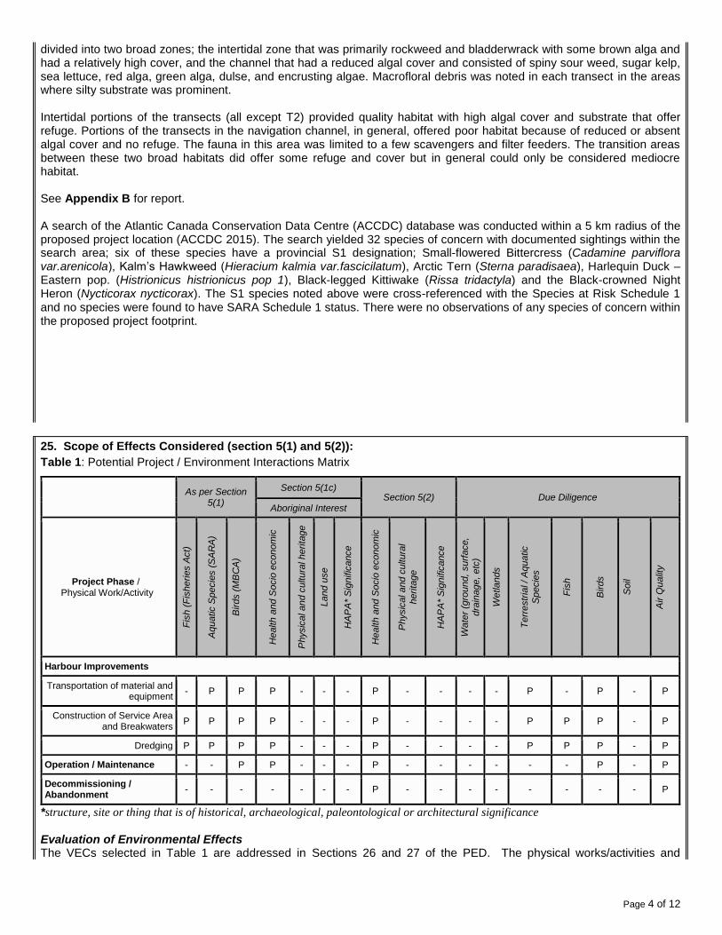
25. Scope of Effects Considered (section 5(1) and 5(2)):
Table 1: Potential Project / Environment Interactions Matrix
As per Section
5(1)
Section 5(1c) Section 5(2) Due Diligence
Aboriginal Interest
Project Phase / Physical Work/Activity
Fis
h (
Fis
heries A
ct)
Aquatic S
pecie
s (
SA
RA
)
Birds (
MB
CA
)
Health a
nd S
ocio
econom
ic
Physic
al and c
ultura
l herita
ge
Land u
se
HA
PA
* S
ignific
ance
Health a
nd S
ocio
econom
ic
Physic
al and c
ultura
l
herita
ge
HA
PA
* S
ignific
ance
Wate
r (g
round,
surf
ace,
dra
inage,
etc
)
Wetla
nds
Te
rrestr
ial / A
quatic
Specie
s
Fis
h
Birds
Soil
Air Q
ualit
y
Harbour Improvements
Transportation of material and equipment
- P P P - - - P - - - - P - P - P
Construction of Service Area and Breakwaters
P P P P - - - P - - - - P P P - P
Dredging P P P P - - - P - - - - P P P - P
Operation / Maintenance - - P P - - - P - - - - - - P - P
Decommissioning / Abandonment
- - - - - - - P - - - - - - - - P
*structure, site or thing that is of historical, archaeological, paleontological or architectural significance Evaluation of Environmental Effects The VECs selected in Table 1 are addressed in Sections 26 and 27 of the PED. The physical works/activities and

Page 5 of 12
required mitigation measures are detailed. The following ratings are based on:
information provided by the proponent;
a review of project related activities;
an appraisal of the environmental setting, and identification of resources at risk;
the identification of potential impacts within the temporal and spatial bounds; and
personal knowledge and professional judgment of the assessor. The significance of project related impacts was determined in consideration of their frequency, the duration and geographical extent of the effects, magnitude relative to natural or background levels, and whether the effects are reversible or are positive or negative in nature. These criteria are indicated in Table 2. Direct effects on navigation are not considered in the Project Effects Determination (PED) report, but any measures necessary to mitigate direct effects will be included as terms and conditions associated with any work approved or permitted pursuant to the Navigation Protection Act.
Table 2: Assessment Criteria for Determination of Significance
Magnitude
Magnitude, in general terms, may vary among Issues, but is a factor that accounts for size, intensity, concentration, importance, volume and social or monetary value. It is rated as compared with background conditions, protective standards or normal variability.
Small Relative to natural or background levels
Moderate Relative to natural or background levels
Large Relative to natural or background levels
Reversibility Reversible Effect can be reversed
Irreversible Effects are permanent
Geographic Extent
Immediate Confined to project site
Local Effects beyond immediate project site but not regional in scale
Regional Effects on a wide scale
Duration
Short Term Between 0 and 6 months in duration
Medium Term Between 6 months and 2 years
Long Term Beyond 2 years
Frequency
Once Occurs only once
Intermittent Occurs occasionally at irregular intervals
Continuous Occurs on a regular basis and regular intervals
Methodology The environmental effects evaluation methodology used in this report focuses the evaluation on those environmental components of greatest concern. The Valued Ecological Components (VECs) most likely to be affected by the project as described are indicated in Table 1. VECs were selected based on ecological importance to the existing environment (above), the relative sensitivity of environmental components to project influences and their relative social, cultural or
economic importance. The potential impacts resulting from these interactions are described below. Scoping This environmental effects evaluation considers the full range of project / environment interactions and the environmental factors that could be affected by the project as defined above and the significance of related impacts with mitigation.
26. Environmental Effects of Project:
Potential Project/Environment Interactions and their effects are outlined below. Transportation of material and equipment:.
Project activities may result in debris/material entering the marine environment.
Potential adverse effects to migratory birds during site access.
Use of heavy machinery may cause short-term elevated noise levels and emissions at the site.

Page 6 of 12
Construction of Service Area, Breakwaters and dredging:.
Project activities may result in debris/material entering the marine environment.
Potential adverse effects to migratory birds during site access.
Potential to enhance populations of predators in the harbour area for the duration of all project phases.
Activities may result in construction related debris or toxic materials affecting marine water quality.
Potential for suspended solids/sediments and turbidity immediately adjacent to the project site affecting fish/fish habitat.
Potential for introduction of invasive species into the marine environment.
Noise and dust generated as a result of the construction activities.
Use of heavy machinery may cause short-term elevated noise levels and emissions at the site.
Potential Impacts to fish habitat due to in-filling for service area and breakwaters.
Safety hazards to workers during construction. Operation/Maintenance:
Safety hazards to workers during operation/maintenance.
Decommissioning/Abandonment:
Safety hazards to workers during decommissioning/abandonment.
27. Mitigation Measures for Project (including Habitat Compensation if applicable):
Potential Effect Mitigation
Construction of Service Area, Breakwaters and dredging
Reversible, immediate degradation of groundwater/marine water quality and fish/fish habitat occurring once and over the short term
A request for review has been submitted to DFO-FPP. The project will incorporate the recommended mitigation once an approval/letter of advice is received.
Any equipment that has been in the marine environment will be cleaned of any sediments, plants or animals and washed with freshwater and/or sprayed with undiluted vinegar prior to being mobilized to the project site.
If a marine mammal (specifically whales or porpoises) is identified within the vicinity of the project, work shall stop until the animal is gone.
Waste materials are not to be buried on site. Demolition debris and waste materials will be disposed of in accordance with Provincial Waste Management Regulations.
Activities must be completed in such a way as to minimize the amount of fines and organic debris that may enter nearby aquatic environments.
Marine equipment may be inspected by PWGSC or DFO to ensure invasive species are not introduced to the marine environment.
No construction or infill material may be obtained from any coastal feature, namely a beach, dune, or coastal wetland.
Onsite crews must have emergency spill clean-up equipment, adequate for the activity involved, must be on-site. Spill equipment will include, as a minimum, at least one 250L (i.e., 55 gallon) overpak spill kit containing items to prevent a spill from spreading; absorbent booms, pillows, and mats; rubber

Page 7 of 12
gloves; and plastic disposal bags. All spills or leaks must be promptly contained, cleaned up, and reported to the 24-Hour Environmental Emergencies Report System (1-800-565-1633).
Visual monitoring of the turbidity will be required in the vicinity of the project to ensure that the turbidity is limited. If excessive change occurs in the turbidity that differs from the existing conditions of the surrounding water body (i.e., distinct colour difference) as a result of the project activities, the work will stop and DFO-Fisheries Protection Program (FPP) will be contacted (506-851-2824).
Small, immediate disturbance of birds/bird habitat over the short term
All machinery must be well muffled. If necessary, trucks may be required to avoid the use of “hammer” braking along specific sections of the route.
Adherence to the regulations set out by the Migratory Birds Convention Act.
Contractors must ensure that food scraps and garbage are not left at the work site.
Concentrations of seabirds, waterfowl, or shorebirds must not be approached when accessing the project site by water, or when ferrying supplies.
All equipment must be maintained in proper running order to prevent leaking or spilling of potentially hazardous or toxic products. This includes hydraulic fluid, diesel, gasoline and other petroleum products.
With the exception of blasting/dredging and related equipment, refueling operations will take place at least 30 metres from any watercourse and harbour and the refueling will take place on a prepared impermeable surface with a collection system.
All equipment to be used in or over the marine environment is to be free from leaks or coating of hydrocarbon-based fluids and/or lubricants harmful to the environment. Hoses and tanks are to be inspected on a regular basis to prevent fractures and breaks.
Construction activities will be carried out during times acceptable to local authorities.
All construction waste material will be disposed of in a provincially approved manner.
Small, immediate disturbance to territorial/aquatic species over the short term
Wetlands or sensitive coastal habitats (i.e., any area in which plant or animal life or their habitats are either rare or especially valuable) must not be accessed nor used as staging areas.
All vessels and machinery should be well muffled, and maintained in proper working order and must be regularly checked for leakage of lubricants or fuel.
Waste or any miscellaneous unused materials must be recovered for either disposal in a designated facility or placed in storage. Under no circumstances will materials be deliberately thrown into the marine or terrestrial environment.
Immediate reduction in air quality due to noise and dust occurring once and over the short term
Construction activities must be carried out during times acceptable to local authorities and smaller, less disturbing equipment will be used where possible.
Dust suppression by the application of water must be employed when required. The project authority shall determine locations where water is to be applied, the amount of water to be applied, and the times at which it shall be applied. Waste oil must not to be used for dust control under any circumstances.
Significance of Adverse Environmental Effects: Although the potential exists for short-term environmental effects during the project, the implementation of recommended mitigation measures will result in insignificant impacts. DFO concludes that this project will not likely contribute to significant adverse environmental effects, provided that the above

Page 8 of 12
recommended mitigation measures are applied.
Operation/Maintenance, Decommissioning/Abandonment
Immediate worker health and safety hazards over the short term
Site access must be restricted to construction personnel and authorized visitors.
All personnel involved with activities must be adequately trained and utilize appropriate personal protective equipment.
Significance of Adverse Environmental Effects: Although the potential exists for short-term environmental effects during the project, the implementation of recommended mitigation measures will result in insignificant impacts. DFO concludes that this project will not likely contribute to significant adverse environmental effects, provided that the above recommended mitigation measures are applied.
28. Description of any Significant Adverse Environmental Effects of the project (after applying mitigation):
Significant adverse environmental effects are unlikely, taking into account mitigation measures.
29. Other Considerations (Public Consultation, Aboriginal Consultation, Follow-up)
Public Consultation The harbor improvements at Leonardville Harbour will increase the overall operational capacity and safety of the harbour and for harbour users (harbour for fishers, aquaculture, recreational users, and tourists) to conduct harbour activities, allowing the harbour to continue being a viable resource to the commercial fishery. The proposed project will increase the sustainability of the commercial fisheries at this location. No negative public concern is expected as a result of this project. In addition, the Harbour Authority consultation indicated that no fishermen, individuals, or groups disapprove of the proposed project. Aboriginal Consultation PWGSC, on behalf of DFO-SCH, carried out an Aboriginal Assessment at Leonardville Harbour in accordance with DFO-SCH’s Preliminary Duty to Consult Assessment Guide. This Guide is intended to provide basic information to DFO-SCH in the Maritimes and Gulf Regions and to assist its Program Managers in making informed, prudent decisions that take into account statutory and other legal obligations, as well as policy objectives, related to Aboriginal and treaty rights. The Supreme Court of Canada has held that the Crown has a duty to consult and, where appropriate, accommodate when the Crown contemplates conduct that might adversely impact potential or established Aboriginal or treaty rights. While there may be other reasons to undertake consultations (e.g. good governance, policy-based, etc.), three elements are required for a legal duty to consult to arise: 1. There is contemplated or proposed Crown conduct; 2. The Crown has knowledge of potential or established Aboriginal or treaty rights; and 3. The potential or established Aboriginal or treaty rights may be adversely impacted by the Crown The Leonardville Harbour Authority advised that there no known Aboriginal vessels operate out of the harbour. To their knowledge, the harbour is not utilized for Aboriginal commercial, traditional, food or ceremonial fisheries. The proposed project site was also reviewed for archaeological potential with known archeological sites (pre-contact, historic, burial) in the area of the site, the scope and type of work to be conducted to deduce a residual archaeological potential. The DFO Area Aboriginal Programs Coordinator was also consulted during the Duty to Consult (DTC) assessment process. As a result of the DTC assessment, aboriginal consultation was not pursued further for this project as it is not likely to be impacts on potential or established Aboriginal or Treaty Rights. Government Consultation Federal and provincial authorities likely to have an interest in the project were consulted by Public Works & Government Services Canada, Environmental Services during the course of this assessment. A project description was distributed to the following federal and provincial authorities: Fisheries and Oceans Canada - Fisheries Protection Program, Transport Canada – Environmental Affairs and Aboriginal Consultation Unit, Transport Canada – Navigable Protections unit, New Brunswick Department of Environment – Environmental Impact Assessment group.

Page 9 of 12
Accuracy and Compliance Monitoring
Site monitoring (accuracy and compliance monitoring) may be conducted to verify whether required mitigation measures were implemented. The proponent must provide site access to Responsible Authority officials and/or its agents upon request.
30. Other Monitoring and Compliance Requirements (e.g. Fisheries Act or Species at Risk Act requirements)
n/a
CONCLUSION
31. Conclusion on Significance of Adverse Environmental Effects:
The Federal Authority has evaluated the project in accordance with Section 67 of Canadian Environmental Assessment Act (CEAA), 2012. On the basis of this evaluation, the department has determined that the project is not likely to cause significant adverse environmental effects with mitigation and therefore can proceed using mitigative measures as outlined.
32. Prepared by: 33. Date: August 12, 2015
34. Name: Jason Keys
35. Title: Environmental Specialist, PWGSC
36. Approved by: _______________________________ 37. Date: ________________
38. Name: Raymond Losier
39. Title: DFO-SCH Senior Project Engineer, NB
DECISION
40. Decision Taken
The project is not likely to cause significant adverse environmental effects, and DFO may exercise its power, duty or function.
The project is likely to cause significant adverse environmental effects, and DFO has decided not to exercise its power, duty or function.
The project is likely to cause significant adverse environmental effects, and DFO will ask the Governor in Council to determine if the significant adverse environmental effects are justified in the circumstances
41. Approved by: _______________________________ 42. Date: ________________
43. Name: Raymond Losier
44. Title: DFO-SCH Senio r Project Engineer, NB

Page 10 of 12
46. References:
ACCDC (Atlantic Canada Conservation Data Centre). ACCDC data response for Leonardville, New-Brunswick. Accessed at PWGSC Atlantic region GIS http://gis2.gisatl.ca/ceaaflex/index.html in August 14, 2015. Harbour Authority Consultation – Personal Communication with Michael Silvaggio, June 11, 2015 DFO-Aboriginal Programs Coordinator – Personal communication and email with Anne Harrington, July 6, 2015. Environment Canada. 2014a. Canadian Climate Normals 1971-2000. Pennfield, New Brunswick. Accessed June 30, 2015 at: http://www.climate.weatheroffice.ec.gc.ca/climate_normals/index_e.html. Environment Canada. 2014b. Species at Risk Registry. Accessed June 30, 2015 at http://www.sararegistry.gc.ca.

Appendix A
Figures

Figure 1: Map of New Brunswick showing the location of the proposed project in Leonardville Harbour.
Location of proposed work

Figure 2: Topographic map indicating proposed project site, Leonardville Harbour, Charlotte County, New Brunswick.
Location of
proposed work

Figure 3: Aerial photo of Leonardville Small Craft Harbour, Charlotte County, New Brunswick.

Figure 4: Site plan showing proposed service area, dredging and breakwaters at Leonardville Harbour, Charlotte County, N.B
Service Area
Existing wharf
Re-enforcing Existing
Breakwater
Proposed Breakwaters
Approx. Dredge Area

Figure 5: Site plan showing proposed service area, dredging and breakwaters at Leonardville Harbour, Charlotte County, N.B


Appendix B
Underwater Benthic Habitat Survey

Appendix C
Marine Sediment Sampling Program Leonardville