Fish Island Area Action Plan 2011 Draft
136
FISH ISLAND FISH ISLAND AREA ACTION PLAN Draft Submission Document DECEMBER 2011
-
Upload
marblemovieskie -
Category
Documents
-
view
213 -
download
0
Transcript of Fish Island Area Action Plan 2011 Draft

FISH ISLANDFISH ISLANDAREA ACTION PLAN
Draft Submission Document
DECEMBER 2011

The AAP Team
Paul Buckenham
Jack Ettinger
Jonny Moore
Sripriya Sudhakar
Simone Williams
Philip Waters
Urban Graphics
James Lewis
Sophie Medhurst
Bally Meeda
Asha Rajput
Mark Woolf
Graphic design and cartography by:
www.urban-graphics.co.ukwww.towerhamlets.gov.uk
C o m m u n i c a t i n g R e g e n e r a t i o n
FISH ISLANDFISH ISLANDAREA ACTION PLAN
Draft Submission Document
DECEMBER 2011

FISH
ISLA
ND
AREA
AC
TIO
N P
LAN
Fish Island is an area with outstanding potential that provides a key link between the established communities of Tower Hamlets and the 2012 Olympic Legacy - the most exciting urban regeneration project in Europe. Against this backdrop, Fish Island will evolve to become an area where people choose to live, work and visit.
With the adopted Core Strategy in place, this Area Action Plan provides local development guidance and sets out investment priorities to support delivery of our vision for Fish Island. The plan will help us all maximise the benefi ts of the Olympics legacy by ensuring a balanced approach to meeting the needs of our community and the wider area.
The Mayor’s Pledges for more affordable family sized housing, maximising job opportunities, and improving the built environment and public realm, will be key regeneration drivers for Fish Island. We want to retain and enhance Fish Island’s distinctive character, whilst allowing for managed transformation to deliver new homes and jobs.
The AAP shows how up to 2,800 new homes in mixed developments could be delivered, including family and affordable housing. A new hub at Hackney Wick supported by better public transport will support the development of sustainable communities.
The biggest challenges will be to make sure that Fish Island becomes better connected to its surroundings and that we plan for the schools, open space and health facilities that will be needed to support new and existing communities.
The Area Action Plan has emerged through extensive consultation with residents, local businesses and land owners. I offer my thanks to everyone who has contributed towards the development of the AAP, all input has been valuable.
Councilor Rabina KhanLead member for Housing
FOREWORD
5
SPATIAL THEMES
Setting the scene001 1
A vision for Fish Island031 2
Connecting Fish Island039 3
Delivering new homes and jobs053 4
A hub at Hackney Wick071 5
Creating a high quality environment081 6
Delivering sustainable regeneration101 7
117
Appendix 2 - Implementation plan
Appendix 1 - Evidence base
Appendix 3 - Managed workspace guidelines
8
CONTENTS
FISH
ISLA
ND
AREA
AC
TIO
N P
LAN

FISH
ISLA
ND
AREA
AC
TIO
N P
LAN
1
1Se
tting
the
scen
e
1
FISH
ISLA
ND
AREA
AC
TIO
N P
LAN
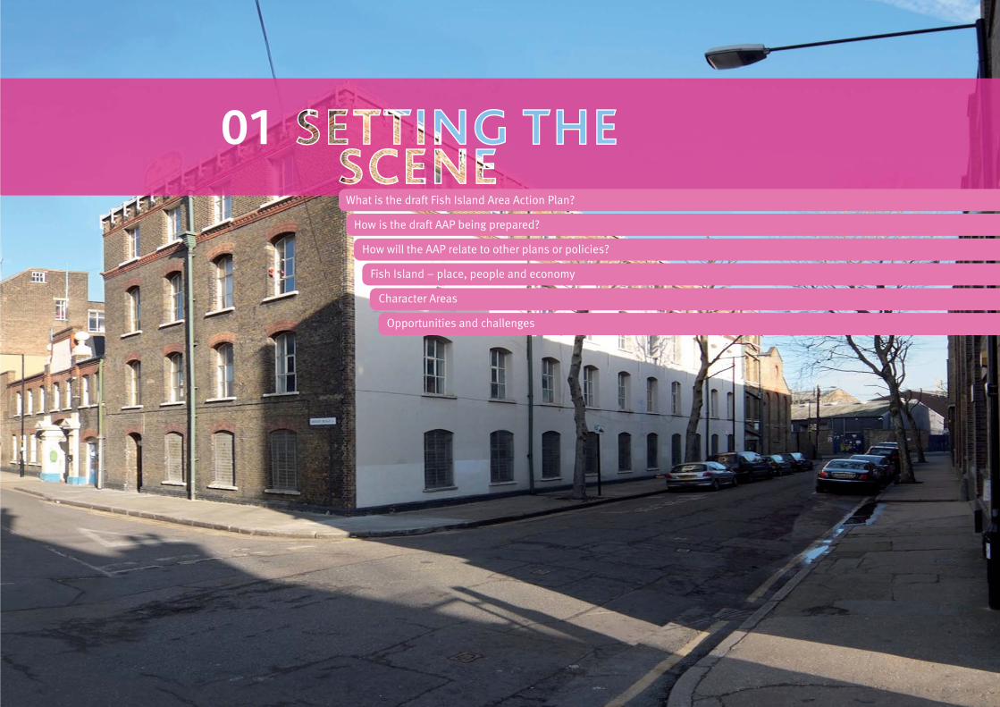
What is the draft Fish Island Area Action Plan?
How is the draft AAP being prepared?
How will the AAP relate to other plans or policies?
Fish Island – place, people and economy
Character Areas
Opportunities and challenges
01

WHAT IS THE DRAFT FISH ISLAND
AREA ACTION PLAN?
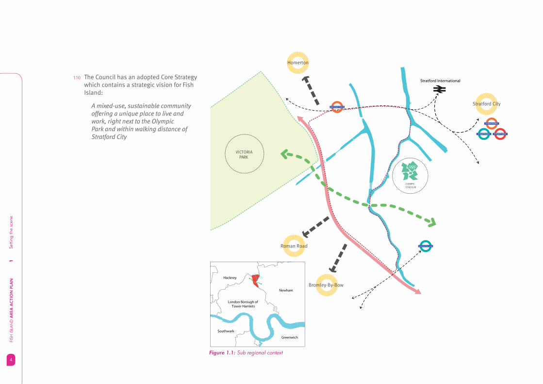
1.1 Fish Island is a place full of potential. It occupies a strategic position between established communities in Tower Hamlets and the biggest and most exciting urban regeneration project in Europe. Unprecedented resources are being invested to develop the sports facilities and infrastructure to stage the Olympic and Paralympic Games in 2012. Figure 1.1 shows Fish Island in relation to its surrounding context.
1.2 The Olympic Park is taking shape with more than 200 hectares of land and waterways (bigger than Hyde Park) being transformed to create a world class setting for the Games. Meanwhile a further £4 billion has been invested in Stratford City next to the Olympic Park, creating thousands of job opportunities and a new focus for business, shopping and leisure.
1.3 During the summer of 2012, the world’s attention will be focussed on east London. But the story won’t stop there – the 2012 Games will be the catalyst to transform the Lower Lea Valley. In time, the Olympic Legacy will deliver permanent world class sports venues alongside thousands of new homes set within sustainable communities, with schools and health facilities, parks and open spaces, new connections and public transport.
SETTING THE SCENE
Setti
ng th
e sc
ene
FISH
ISLA
ND
AREA
AC
TIO
N P
LAN
2
3
1Se
tting
the
scen
e
3
FISH
ISLA
ND
AREA
AC
TIO
N P
LAN
1.4 The lasting Olympic legacy will be more than physical – it will help to raise the overall living standards for people in east London, creating access to new jobs, training opportunities, education, sport and physical activity. A whole new quarter of London will grow and develop, becoming a destination for visitors and a place that people will choose to live, work and enjoy. The priority for regeneration is that within 20 years the communities who host the 2012 Olympic and Paralympic Games will have the same social and economic chances as their neighbours across London. This is often called the principle of ‘convergence’.
1.5 Tower Hamlets Council wants to maximise the Olympic Legacy opportunities for everyone living or working in Tower Hamlets. To help achieve this we need to look closely at the future of Fish Island to see how this area can respond to the unique set of opportunities by providing the link between the established communities in Tower Hamlets and the Olympic Legacy development.
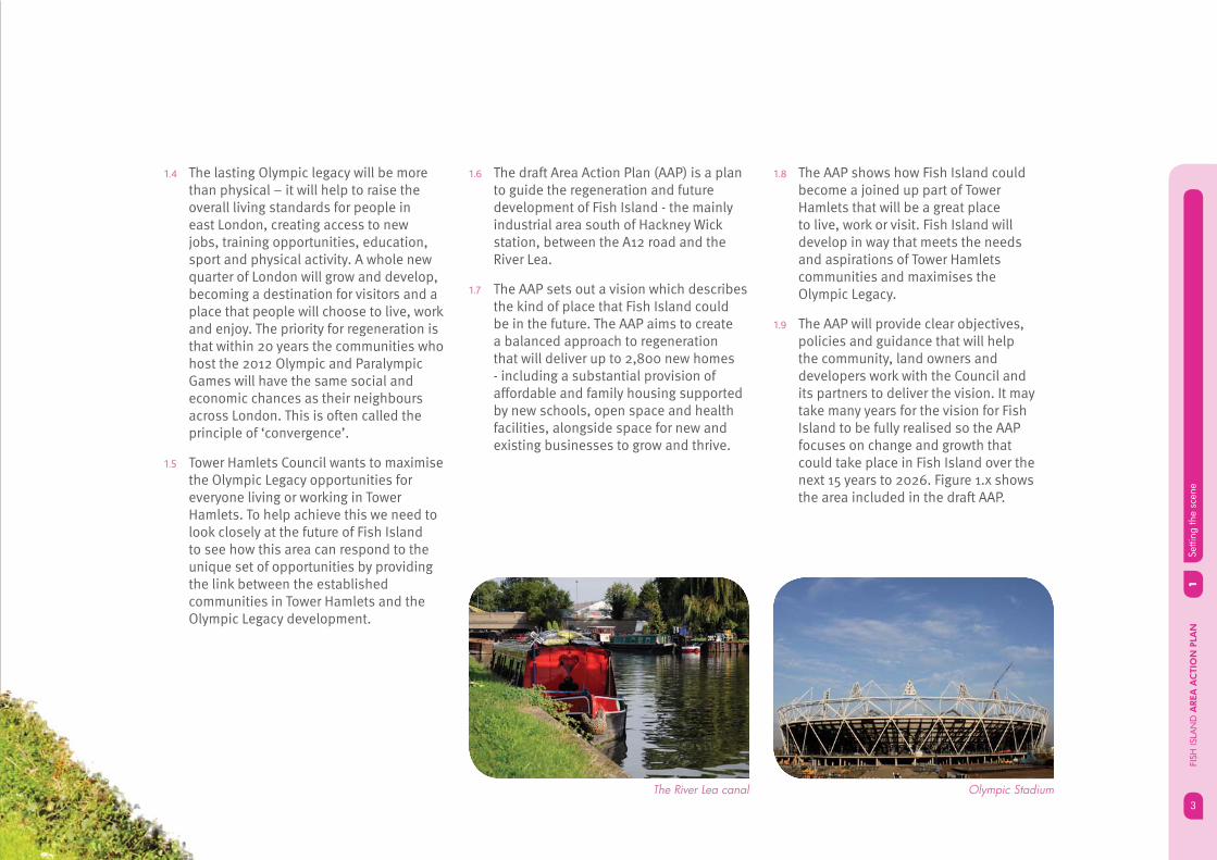
1.6 The draft Area Action Plan (AAP) is a plan to guide the regeneration and future development of Fish Island - the mainly industrial area south of Hackney Wick station, between the A12 road and the River Lea.
1.7 The AAP sets out a vision which describes the kind of place that Fish Island could be in the future. The AAP aims to create a balanced approach to regeneration that will deliver up to 2,800 new homes - including a substantial provision of affordable and family housing supported by new schools, open space and health facilities, alongside space for new and existing businesses to grow and thrive.
1.8 The AAP shows how Fish Island could become a joined up part of Tower Hamlets that will be a great place to live, work or visit. Fish Island will develop in way that meets the needs and aspirations of Tower Hamlets communities and maximises the Olympic Legacy.
1.9 The AAP will provide clear objectives, policies and guidance that will help the community, land owners and developers work with the Council and its partners to deliver the vision. It may take many years for the vision for Fish Island to be fully realised so the AAP focuses on change and growth that could take place in Fish Island over the next 15 years to 2026. Figure 1.x shows the area included in the draft AAP.
Olympic StadiumThe River Lea canal
1Se
tting
the
scen
eFI
SH IS
LAN
D A
REA
AC
TIO
N P
LAN
4
1.10 The Council has an adopted Core Strategy which contains a strategic vision for Fish Island:
A mixed-use, sustainable community offering a unique place to live and work, right next to the Olympic Park and within walking distance of Stratford City
Stratford International
Stratford City
London Borough of Tower Hamlets
Newham
Greenwich
Southwark
Hackney
OLYMPICSTAD IU M
VICTORIA PARK
Homerton
Bromley-By-Bow
Roman Road
STRATFORD
STRATFORD
STRATFORD
PUDDING MILL LANE
HACKNEY WICK
A12
A12
Figure 1.1: Sub regional context
PUDDING MILL LANE

5
1Se
tting
the
scen
e
5
FISH
ISLA
ND
AREA
AC
TIO
N P
LAN
Figure 1.2: Aerial view of Fish Island
1Se
tting
the
scen
eFI
SH IS
LAN
D A
REA
AC
TIO
N P
LAN
6
1.13 The AAP will show how the community, local authorities, land owners, public bodies can work together to realise opportunities and deliver a sustainable future for Fish Island.
1.14 The Council believes an Area Action Plan is the right way of coordinating and implementing the spatial vision for Fish Island in the Core Strategy. It will focus on managing change over the next 15 years by providing a mix of detailed guidance, policies and priorities for investment. The AAP will show how the local community, the Council and its partners, land owners, developers and public organisations can play a part in realising opportunities and delivering a sustainable future for Fish Island.
1.15 The draft AAP will be used by:
the local community to infl uence • sustainable development in Fish Island;
land owners, business owners to help • them contribute to delivering the overall vision;
local government and public sector • organisations to bring forward infrastructure that supports sustainable development;
local planning authorities making • decisions on planning applications.
1.11 The Core Strategy provides a strategic vision for Fish Island and acknowledges that because of the complex issues that would have to be addressed – including the managed release of strategic industrial land - an Area Action Plan should be prepared.
1.12 The draft National Planning Policy Framework (NPPF) says that each local planning authority should produce a Local Plan for its area and additional development plan documents should only be used where clearly justifi ed.
7
1Se
tting
the
scen
e
7
FISH
ISLA
ND
AREA
AC
TIO
N P
LAN
HOW IS THE DRAFT AAP BEING
PREPARED?
1.16 The Council is not starting the draft Area Action Plan from scratch. Information sources (known as the evidence base) help to build the foundations of the document. These sources include work carried out to prepare the draft Hackney Wick and Fish Island Masterplan, feedback from previous consultation, and technical studies that support the Core Strategy.
DRAFT HACKNEY WICK AND FISH ISLAND
MASTERPLAN
1.17 In 2007, Tower hamlets Council, Hackney Council and LTGDC embarked on a master-planning process for Hackney Wick and Fish Island to ensure the vision and aspirations for the area are aligned. The work undertaken during the master-planning process has helped to prioritise investment in public realm improvements prior to the 2012 Olympic Games and forms part of the evidence base for the Core Strategy and draft Fish Island AAP.
CONSULTATION AND ENGAGEMENT
1.18 Information received from previous LDF consultation has been used to help shape the fi rst engagement draft AAP. A full picture of the feedback received is available in the LDF Consultation Report.
1.19 Consultation on the fi rst (engagement) draft of the AAP took place between May and July 2011. Over 100 people took part in consultation events and written comments were received from 123 individuals or organisations. The main issues raised in relation to the AAP were:
Support for improved connections but • mixed views on the position and type of connections over the canals;
More clarity on land use polices should be • provided;
More support for creative industries could • be included in the AAP;
Greater emphasis on the importance of • the waterways in defi ning local character should be included;
Support for protecting heritage assets in • and beyond the existing conservation area;
Concerns about the impact of the proposed • waste to energy facility.

1Se
tting
the
scen
eFI
SH IS
LAN
D A
REA
AC
TIO
N P
LAN
8
1.20 The proposed submission version of the AAP has been amended to address these issues as far as possible within the context of the Core Strategy. A detailed consultation report sets out the full range of issues and the Council’s response. An explanation has been provided for ideas and issues which cannot be accommodated.
TECHNICAL STUDIES AND ASSESSMENTS
1.21 Technical studies include evidence base developed for the Core Strategy and related Council strategies. Examples relevant to the draft Fish Island AAP include the Industrial Land Study, the Urban Characterisation Study and the Fish Island Conservation Area Character Appraisal and Management Plan (2009). A borough wide employment study with a specifi c focus on Fish Island was also undertaken in 2011. Appendix 1 lists the evidence base that underpins the AAP.
1.22 The AAP is also informed by the results of a Sustainability Appraisal and Equalities Impact Assessment. These documents have been published alongside the AAP.

9
1Se
tting
the
scen
e
9
FISH
ISLA
ND
AREA
AC
TIO
N P
LAN
HOW WILL THE AAP RELATE TO
OTHER PLANS OR POLICIES?
LONDON PLAN
1.23 The London Plan adopted in 2011 is the overall strategic plan for London, setting out an integrated economic, environmental, transport and social framework for London over the next 20-25 years. The London Plan states that successful, viable and sustainable regeneration of the Olympic Park and surrounding area is the London Mayor’s highest regeneration priority. The Mayor of London will work with partners to realise the full benefi ts of the 2012 games for London. The Mayor of London’s priorities for the Olympic Park and the surrounding areas will be set out in his Olympic Legacy Supplementary Planning Guidance (OLSPG).
OLYMPIC LEGACY SUPPLEMENTARY
PLANNING GUIDANCE (OLSPG)
1.24 The Mayor of London’s OLSPG will set out strategic policies and guidance for the Olympic Park and surrounding areas. The draft OLSPG was published for consultation on 6 September 2011. The OLSPG will help to inform the more detailed guidance in the Area Action Plan.
TOWER HAMLETS LOCAL DEVELOPMENT
FRAMEWORK (LDF)
1.25 The Local Development Framework (LDF) guides the regeneration and sustainable development of Tower Hamlets by implementing the spatial aspects of the Community Plan. It is a suite of planning documents which include the Core Strategy, Development Plan Documents (DPDs), Supplementary Planning Documents (SPDs) and Area Action Plans and masterplans.
LDFTOWER HAMLETS
Adopted September 2010
2025
Consultation draft - August 2011
Olympic LegacySupplementary Planning Guidance
THE LONDON PLANSPATIAL DEVELOPMENT STRATEGY FOR GREATER LONDONJULY 2011
1Se
tting
the
scen
eFI
SH IS
LAN
D A
REA
AC
TIO
N P
LAN
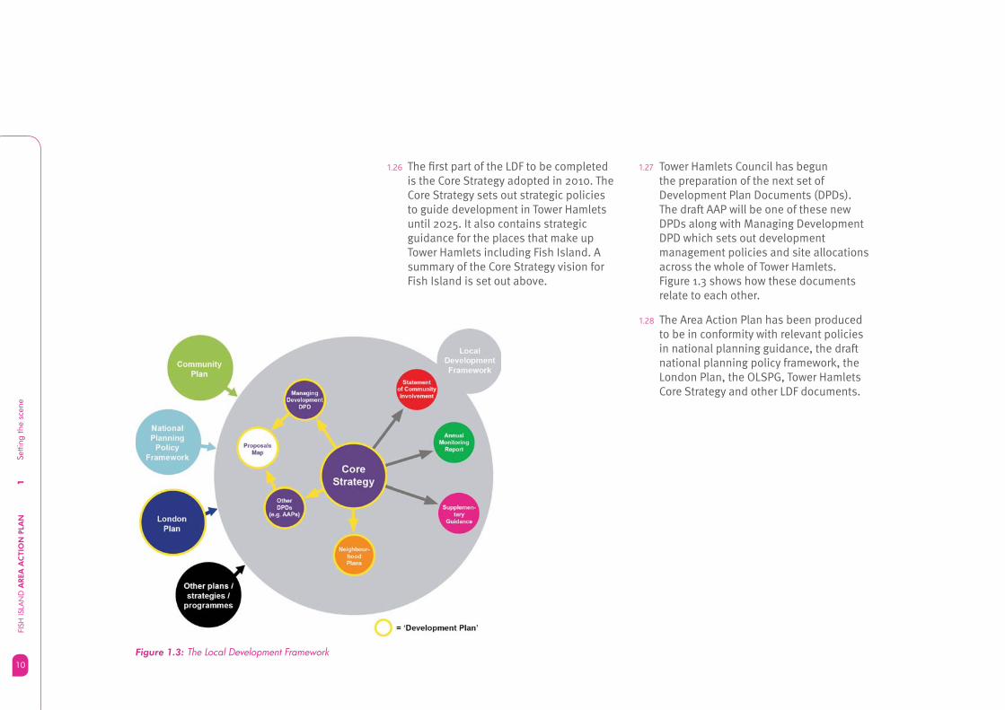
10Figure 1.3: The Local Development Framework
1.26 The fi rst part of the LDF to be completed is the Core Strategy adopted in 2010. The Core Strategy sets out strategic policies to guide development in Tower Hamlets until 2025. It also contains strategic guidance for the places that make up Tower Hamlets including Fish Island. A summary of the Core Strategy vision for Fish Island is set out above.
1.27 Tower Hamlets Council has begun the preparation of the next set of Development Plan Documents (DPDs). The draft AAP will be one of these new DPDs along with Managing Development DPD which sets out development management policies and site allocations across the whole of Tower Hamlets. Figure 1.3 shows how these documents relate to each other.
1.28 The Area Action Plan has been produced to be in conformity with relevant policies in national planning guidance, the draft national planning policy framework, the London Plan, the OLSPG, Tower Hamlets Core Strategy and other LDF documents.
11
1Se
tting
the
scen
e
11
FISH
ISLA
ND
AREA
AC
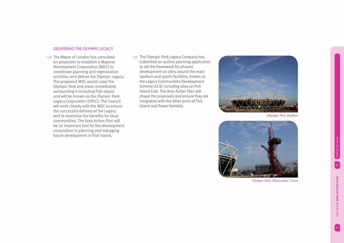
TIO
N P
LAN
DELIVERING THE OLYMPIC LEGACY
1.29 The Mayor of London has consulted on proposals to establish a Mayoral Development Corporation (MDC) to coordinate planning and regeneration activities and deliver the Olympic Legacy. The proposed MDC would cover the Olympic Park and areas immediately surrounding it including Fish Island and will be known as the Olympic Park Legacy Corporation (OPLC). The Council will work closely with the MDC to ensure the successful delivery of the Legacy and to maximise the benefi ts for local communities. The Area Action Plan will be an important tool for the development corporation in planning and managing future development in Fish Island.
1.30 The Olympic Park Legacy Company has submitted an outline planning application to set the framework for phased development on sites around the main stadium and sports facilities, known as the Legacy Communities Development Scheme (LCS) including sites on Fish Island East. The Area Action Plan will shape the proposals and ensure they are integrated with the other parts of Fish Island and Tower Hamlets.
Olympic Park Stadium
Olympic Park Observation Tower

1Se
tting
the
scen
eFI
SH IS
LAN
D A
REA
AC
TIO
N P
LAN
12
Figure 1.4: Fish Island – Tower Hamlets context
FISH ISLAND – PLACE, PEOPLE
AND ECONOMY
1.31 Fish Island is located in the north east part of Tower Hamlets in Bow East ward, close to Hackney Wick, on the boundary with Hackney and Newham Councils. The area covered by this AAP is bordered by the River Lea, the London Overground railway and the A12 Blackwall Tunnel approach road. Fish Island is so called because of the street names, which include Roach Road, Dace Road and Bream Street.
HISTORIC CONTEXT
1.32 The area covered by the Fish Island AAP was previously known as Old Ford and up until the 1800s was a predominantly marshy area alongside the banks of the River Lea, Canals were cut across the marsh in the late 18th century and early 19th century. Railways followed shortly afterwards and Industry began to establish here in the mid 1800s.
1.33 The sale of surplus railway land led eventually to the development of a small ”factory town” in the southern part of Old Ford Marsh in the second part of the 19th century. A network of new roads, with terraced houses, factories and a school were developed between the Northern Outfall Sewer (now known as the Greenway) and the North London railway. The enclosed area was known to local residents as “the Island”; and later, Fish Island.

13
1Se
tting
the
scen
e
13
FISH
ISLA
ND
AREA
AC
TIO
N P
LAN
1.34 By the beginning of the 20th century Fish Island was an area of intense and diverse industrial activity including food processing and importing and processing and raw materials such as crude oil, rubber and iron and engineering works that used the imported materials.
Figure 1.7: Fish Island in 2010Figure 1.5: Historic map: 1896 Figure 1.6: Historic map: 1968
1.35 The areas north and south of the Hertford Union Canal suffered heavy bomb damage in the Second World War. Post war redevelopment saw much of the housing cleared and the area developed as predominantly industrial with few other uses.
1.36 The Blackwall Tunnel Approach Road, originally known as the East Cross Route, was constructed in the early 1970s as part of a proposed network of high speed motorways intended to serve central London. The road is now part of the A12 and is strategically important as an urban motorway.

1Se
tting
the
scen
eFI
SH IS
LAN
D A
REA
AC
TIO
N P
LAN
14
THE AREA TODAY
1.37 Industrial activity defi nes much of the character of Fish Island today. There is a mix of industrial buildings, ranging from two and three-storey brick warehouses and factories dating from the 19th century, to more recent post-war factories, and storage and distribution units.
1.38 Some of the older factory buildings have been converted to smaller units that provide space for small businesses. There is a signifi cant cluster of creative industries focussed around art and design. Some 600 artists’ studios are clustered in Fish Island in the area south of Monier Road and close to Hackney wick Station.
1.39 There are other clusters of buildings refl ecting the industrial heritage of Fish Island close to Hackney wick station and south of Monier Road. Elsewhere newer industrial units have been created north of Monier Road, towards the A12 and in the areas north and south of White Post Lane.
1.40 Fish Island suffers from extreme severance and is cut off from the west by the A12 road with only a limited number of crossing points for pedestrians, cyclists and other vehicles.
1.41 The Hertford Union and Lea Navigation canals that run through Fish Island, along with the River Lea, help to defi ne the unique waterside character of the area. Recent improvements to the towpath network have helped to enhance connections along the waterways however there are currently few bridges, reducing connectivity within Fish Island.
1.42 The Greenway is an important route for pedestrians and cyclists that connects Victoria Park through Fish Island to Pudding Mill DLR Station and Stratford High Street via the southern edge of the Olympic Park.
Olympic Park
Old Ford Lock
View looking south from Hackney Wick Station
15
1Se
tting
the
scen
e
15
FISH
ISLA
ND
AREA
AC
TIO
N P
LAN
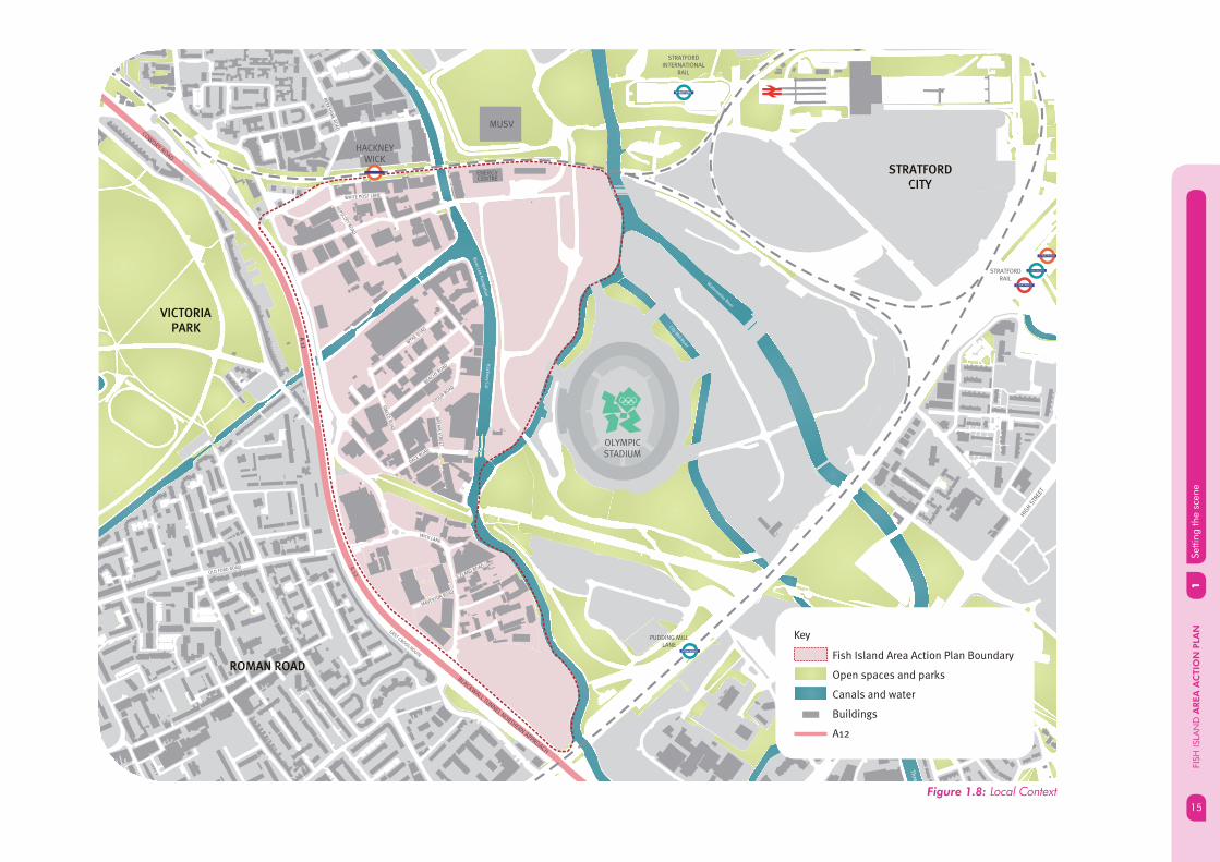
Figure 1.8: Local Context
Waterw
orks River
City Mill River
Ha
ckn
ey C
ut
Rive
r Lee
Na
viga
tion
A 12
BLACKWALL TUNNEL NORTHERN APPROACH
Thre
e
HIG
H S
TREE
T
COWDRY ROAD
Bow Back River
A 1
2
OLYMPICSTADIUM
VICTORIA
PARK
HACKNEY WICK
MUSV
ENERGYCENTRE
EAST CROSS ROUTE
HIG
H S
TREE
T
BER
KS
HIR
E RO
AD
ROTHBURY ROAD
WICK LANE
MAVERTON ROAD
WHITE POST LANE
BEACHY ROAD
BR
EA
M S
TRE
ET
WYKE R
OAD
STOUR ROAD
DACE ROAD
SM
EE
D R
OA
D
HEPSC
OTT RO
AD
ICELAND ROAD
OLD FORD ROAD
D
STRATFORD
CITY
STRATFORD
STRATFORDRAIL
STRATFORDINTERNATIONAL
RAIL
PUDDING MILLLANE
STRATFORD
STRATFORD
STRATFORD
STRATFORD
ROMAN ROAD
Key
Fish Island Area Action Plan Boundary
Open spaces and parks
Canals and water
Buildings
A12
1Se
tting
the
scen
eFI
SH IS
LAN
D A
REA
AC
TIO
N P
LAN
16
1.43 The northern part of Fish Island benefi ts from good public transport connections to north and east London via the London Overground services at Hackney Wick Station. Pudding Mill Lane DLR station is becoming increasingly important due to the direct connections via services to Stratford, Canary Wharf and central London. Bus services provide links to Stratford, Newham, Hackney, Bromley by Bow and Poplar.
1.44 Fish Island currently has a very small residential population due to the mainly industrial character. Planning policies have restricted residential development, apart from a limited number of live/work developments. Approximately 600 people currently live within the AAP boundary. This is very low for an area so close to central London and contrasts with nearly 9000 people living within 5 just minutes walk of Fish Island. The existing residential population is also relatively young. 40% are aged between 25-49 years old.
1.45 Fish Island is one of few remaining areas in Tower Hamlets that has a concentration of heavy industrial uses, notably food processing, waste management, printing, motor trades and construction industry. Proximity to the A12 has resulted in warehousing, catering and distribution activities, which support the City of London and Canary Wharf.
1.46 Fish Island also has a growing number of creative and cultural industries that sit alongside and compliment the more traditional industries, taking advantage of the conversion of older buildings that are no longer suitable for modern requirements.
1.47 Research undertaken by the London Development Agency (LDA) identifi ed 610 studios across the Hackney Wick and Fish Island area. The studio spaces are not only occupied by creative practitioners such as designers, artists & galleries but also by a variety of supporting businesses from printers to fi nancial consultants.
1.48 A separate study by MUF Architecture, also commissioned by the LDA showed that Fish Island had a cluster of 600 small businesses engaged in a wide range of economic activities.

FISH ISLAND
SOUTH
FISH ISLAND
NORTH
FISH ISLAND
MID
FISH ISLAND
EAST
STRATFORD
INTERNATIONAL
HACKNEY
WICK
EAST CROSS ROUTE
A 12
BLACKWALL TUNNEL NORTHERN APPROACH
A 1
2
A 12
RIV
ER
LEA
HERTFORD U
NION C
ANAL
OLYMPICSTADIUM
VICTORIA
PARK
STRATFORD
CITY
ROMAN
ROAD
BOW
17
1Se
tting
the
scen
e
17
FISH
ISLA
ND
AREA
AC
TIO
N P
LAN
Figure 1.9: Character Areas
Key
Fish Island Area Action Plan Boundary
Fish Island North
Fish Island Mid
Fish Island Area East
Fish Island South
The Greenway
Rail
A12
Waterways
CHARACTER AREAS OF FISH ISLAND
1.49 The existing characteristics of Fish Island have helped to identify four character areas, which benefi t from four different place making responses, which have infl uenced the AAP.

NORTH1
Setti
ng th
e sc
ene
FISH
ISLA
ND
AREA
AC
TIO
N P
LAN
18
Artist Studios
Queens Yard
Hackney Wick Station
Roach Point Crossing over the Hertford Union CanalView from Hertford Union Canal of Opportunity Site 2 (McGrath Waste Transfer Site)
Opportunity Site 1 (Site North of White Post Lane)
CHARACTER AREAS
FISH ISLAND NORTH
1.50 This is the area between the Overground railway, the A12, the Hertford Union canal and the Lea Navigation. This area is mainly industrial in character with warehousing, artist studios and out-door storage space, and some derelict sites and a scrap yard. Hackney Wick Station and a cluster of older industrial buildings on White Post Lane including Queens Yard and the White Building are the main local land marks. A pedestrian bridge provides access across the A12 to Victoria Park; however the quality of the environment where the bridge lands in Wallis Road is poor. White Post Lane provides a connection across the Lea Navigation to Fish Island East .
FISH ISLAND
SOUTH
FISH ISLAND
NORTH
FISH ISLAND
MID
FISH ISLAND
EAST

19
1Se
tting
the
scen
e
19
FISH
ISLA
ND
AREA
AC
TIO
N P
LAN
Pedestrian bridge crossing the A12 provides access to Victoria Park

Iron Works near Old Ford LocksConservation Area
Old Ford LocksH. Forman & Son on Stour Road
A12 underpass to Victoria Park on the GreenwayKey connection - Monier Road
1Se
tting
the
scen
eFI
SH IS
LAN
D A
REA
AC
TIO
N P
LAN
20
MIDFISH ISLAND MID
1.51 The area south of the Hertford Union canal to the Greenway includes a mix of older and modern industrial buildings. The largest singles site is the former Scottish and Newcastle brewery site on Wyke Road. The cluster of late 19th and early 20th century factory buildings within Fish Island Conservation Area give the streets around Stour Road and Dace Road a strong identity. Many of these buildings have been converted to artist studios or managed space for small businesses. There are two recent live work developments: Omega Works on the junction of the Hertford Union Canal and Lea Navigation and Iron Works near Old Ford Locks. H. Forman and Sons smoked salmon factory on Stour Road is another a prominent local landmark. The Greenway marks the southern extent of Mid Fish Island and provides walking and cycling routes towards Victoria Park and east towards Pudding Mill Lane.
FISH ISLAND
SOUTH
FISH ISLAND
NORTH
FISH ISLAND
MID
FISH ISLAND
EAST

Old Ford Locks21
1Se
tting
the
scen
e
21
FISH
ISLA
ND
AREA
AC
TIO
N P
LAN
SOUTH1
Setti
ng th
e sc
ene
FISH
ISLA
ND
AREA
AC
TIO
N P
LAN
22
Bow Midland Yard WestWick Lane crossing the A12
417 Wick LanePedestrian bidge over the A12
Live-work developmentMission Church on Crown Close
FISH ISLAND
SOUTH
FISH ISLAND
NORTH
FISH ISLAND
MID
FISH ISLAND
EAST
FISH ISLAND SOUTH
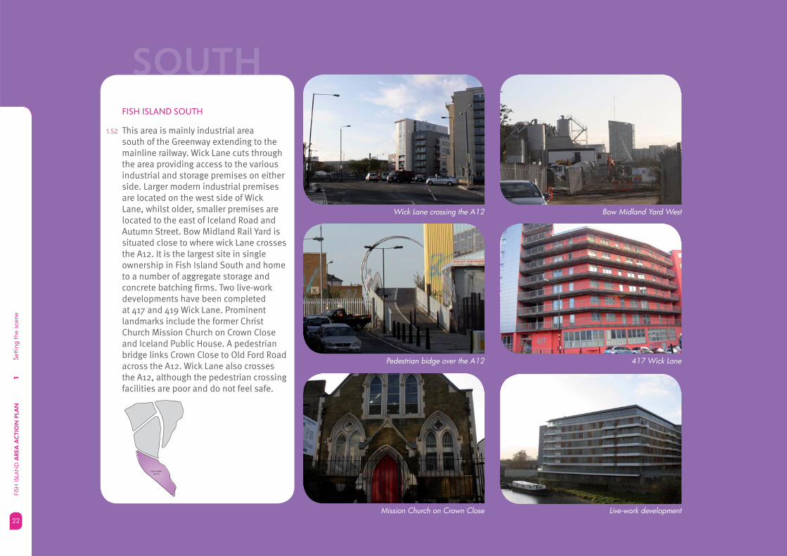
1.52 This area is mainly industrial area south of the Greenway extending to the mainline railway. Wick Lane cuts through the area providing access to the various industrial and storage premises on either side. Larger modern industrial premises are located on the west side of Wick Lane, whilst older, smaller premises are located to the east of Iceland Road and Autumn Street. Bow Midland Rail Yard is situated close to where wick Lane crosses the A12. It is the largest site in single ownership in Fish Island South and home to a number of aggregate storage and concrete batching fi rms. Two live-work developments have been completed at 417 and 419 Wick Lane. Prominent landmarks include the former Christ Church Mission Church on Crown Close and Iceland Public House. A pedestrian bridge links Crown Close to Old Ford Road across the A12. Wick Lane also crosses the A12, although the pedestrian crossing facilities are poor and do not feel safe.

Big Yellow Self Storage23
1Se
tting
the
scen
e
23
FISH
ISLA
ND
AREA
AC
TIO
N P
LAN

EAST1
Setti
ng th
e sc
ene
FISH
ISLA
ND
AREA
AC
TIO
N P
LAN
24
Energy Centre off White Post Lane Energy Centre off White Post Lane
View of Fish Island East from Hertford Union Canal
View overlooking Hackney Cut towards Fish Island East
FISH ISLAND
SOUTH
FISH ISLAND
NORTH
FISH ISLAND
MID
FISH ISLAND
EAST
FISH ISLAND EAST
1.53 The area between the Lea Navigation and River Lea which will be developed as part of the Olympic Legacy and is now mainly a cleared site. The main buildings of prominence are Kings Yard Olympic Energy Centre off White Post Lane which was formerly part of the Clarico Sweet Factory and Lock Keepers cottage adjacent to Old Ford Lock in the southern part of this area.
1.54 The Hertford Union Canal, Lea Navigation and River Lea help to defi ne the different sub areas but equally act as unifying elements by promoting movement between and through the character areas either on water or along the waterside footways.

View of Fish Island East from Hackney Cut with the Olympic Stadium behind25
1Se
tting
the
scen
e
25
FISH
ISLA
ND
AREA
AC
TIO
N P
LAN

1Se
tting
the
scen
eFI
SH IS
LAN
D A
REA
AC
TIO
N P
LAN
26
OPPORTUNITIES AND
CHALLENGES
1.55 Delivering a future vision for Fish Island will depend on understanding the opportunities and challenges presented by the current context. In summary these include:
The Olympic inheritance• – The Olympic Games and Legacy Development will provide a catalyst for regeneration by bringing investment in infrastructure and changing the perception of the area. Inheritance will include a multi-use sports venue, the Olympic stadium and aquatics centre, a combined heat and power station, new or improved bridges, opportunities for investment in the International Broadcast Centre (IBC) / Media Broadcast Centre (MBC).
Connections• – Overcoming the perception of severance caused by the A12 road will be vital if Fish Island is to become a more integrated place and connect with Tower Hamlets’ communities. Similarly strong and direct connections across the Lea Navigation, Hertford Union Canal and River Lea will be needed to link Fish Island with the major regeneration opportunities created by the Olympic investment. Maximising the proximity to strategic transport connections such as Stratford Regional and International Stations will help to improve connectivity and support future growth.
A12
Barriers to movement
Wa
terw
orks R
iver
Bow Bac
STRATFORDINTERNATIONAL
HACKNEY WICK
PUDDING MILL LANE
BARRIERS TO MOVEMENT
LOCALCONNECTIONS
BARRIERS TO MOVEMENT
OLYMPICSTADIUM
VICTORIA PARK
STRATFORD

27
1Se
tting
the
scen
e
27
FISH
ISLA
ND
AREA
AC
TIO
N P
LAN
• Character and Heritage - Fish Island boasts a strong and unique character as a result of its historic buildings, interesting streetscape and remaining industrial features. These elements should be seen as a signifi cant regeneration opportunity to infl uence future development proposals and contribute towards creating a sense of place.
Creative and Cultural Industries• - Over the past few decades the creative economy has spread east from Soho into areas such as Clerkenwell and Shoreditch and now into the East End. There is a signifi cant cluster of CCIs within Fish Island and there are opportunities to consolidate and promote this cluster to contribute to a diverse local economy.
Waterways• - Fish Island benefi ts from being crossed north to south by the Lea Navigation and River Lea and West to East by the Hertford Union Canal. These waterways and their tow paths provide signifi cant opportunities for walking, cycling, boating, transportation of goods and waste, and improving ecology as well as providing a setting for future development.
Hertford Union Canal
Big Yellow Self Storage Chimney

1Se
tting
the
scen
eFI
SH IS
LAN
D A
REA
AC
TIO
N P
LAN
28
• Parks and open space - Fish Island is situated between two signifi cant public parks, Victoria Park to the west and the future Legacy Park on the east. There are opportunities to make better connections to these important open spaces for the benefi t of new communities and to establish smaller local parks and open spaces within the AAP boundary.
Development pressure• - Ensuring a balanced and managed approach to the release of industrial land to ensure that mixed use and residential development does not come forward in a piecemeal way.
Victoria Park
Fish Island South Industrial Land
• Responding to fl ood risk – the whole of Fish Island is subject to tidal and fl uvial fl ood risk from the Thames and River Lea. This will infl uence the nature and design of future development in the area.
• Supporting new communities – ensuring residential development is supported with the right social infrastructure, such as schools, health and community facilities in the right locations and at the right time will be essential to create balanced, sustainable communities.

29
1Se
tting
the
scen
e
29
FISH
ISLA
ND
AREA
AC
TIO
N P
LAN
Figure 1.10: Land Ownership
Waterw
orks River
City Mill River
Ha
ckn
ey C
ut
Rive
r Lee
Na
viga
tion
A 12
BLACKWALL TUNNEL NORTHERN APPROACH
A 1
2
OLYMPICSTADIUM
VICTORIA PARK
STRATFORDINTERNATIONAL
STRATFORDCITY
HACKNEY WICK
PUDDING MILL LANE
MUSV
ENERGYCENTRE
EAST CROSS ROUTE
BER
KS
HIR
E RO
AD
ROTHBURY ROAD
WICK LANE
MAVERTON ROAD
WHITE POST LANE
BEACHY ROAD
BR
EA
M S
TRE
ET
WYKE R
OAD
STOUR ROAD
DACE ROAD
SM
EE
D R
OA
D
HEPSC
OTT RO
AD
ICELAND ROAD
OLD FORD ROAD
D
ROMAN ROAD
STRATFORD
• Land ownership – Fish Island has a complex pattern of land ownership, with very little public ownership. This means that land owners, business owners and developers will need to work collaboratively to implement the future vision.
Key
Fish Island Area Action Plan Boundary
Individual land ownerships within Fish Island
A12
1Se
tting
the
scen
eFI
SH IS
LAN
D A
REA
AC
TIO
N P
LAN
30
STRATFORD
CITY
CANARY
WHARF
CITY OF
LONDON
FISH
ISLAND
Figure 1.11: Fish Island and the major growth areas in east London
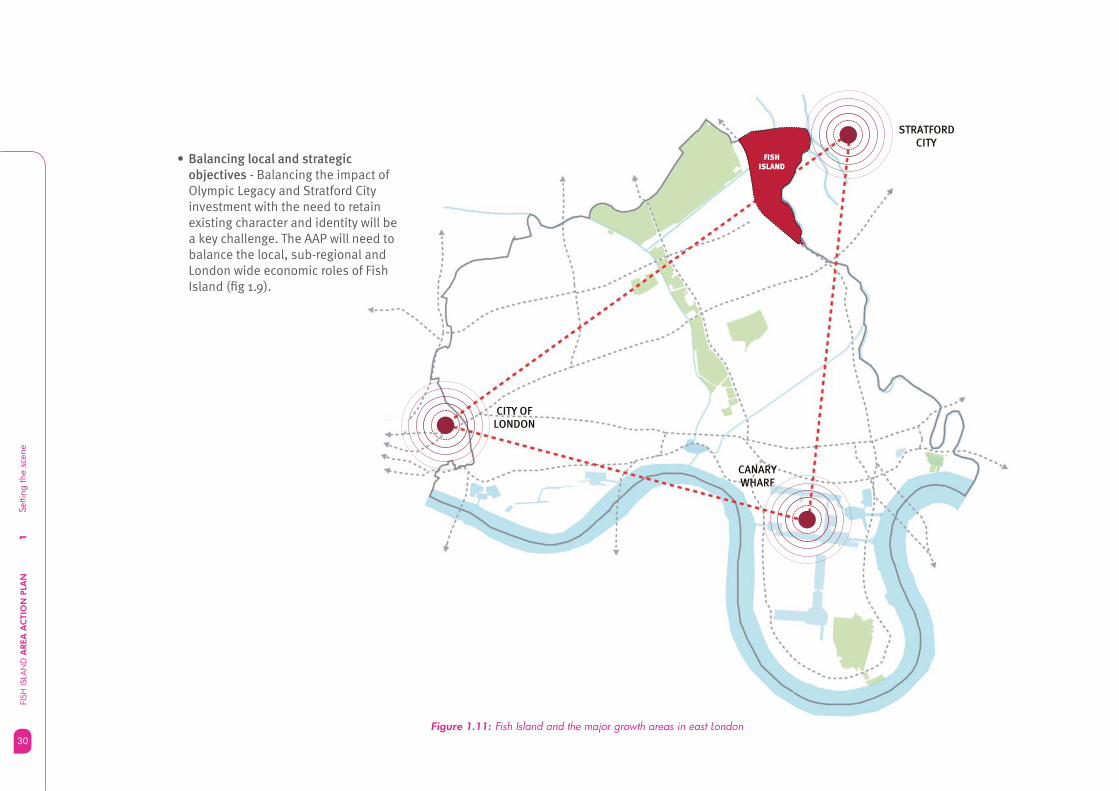
Balancing local and strategic • objectives - Balancing the impact of Olympic Legacy and Stratford City investment with the need to retain existing character and identity will be a key challenge. The AAP will need to balance the local, sub-regional and London wide economic roles of Fish Island (fi g 1.9).

31
2A
vis
ion
for
Fish
Isla
nd
31
FISH
ISLA
ND
AREA
AC
TIO
N P
LAN
Fish island character areas
How will the AAP deliver the vision?
02

2.1 Tower Hamlets Core Strategy contains a strategic vision for Fish Island. The Area Action Plan takes the vision to a new level of detail. The AAP vision is set out below.
2.2 The AAP vision takes account of the opportunities and challenges and is based on the fundamental principles of:
Creating a well connected place that • becomes a joined up part of East London
Making the most of the • transformational effect of the Olympic Legacy investment and Stratford City
Managing the release of industrial land • for other uses that contribute towards creating sustainable communities
Retaining a strong identify and sense • of place based on the unique industrial heritage and waterside location
Ensuring that new homes are • supported with the right infrastructure.
2.3 The Area Action Plan estimates that up to 2,800 new homes could come forward in Fish Island alongside 175,000 sq.m. of new or revitalised employment fl oor space, creating around 3,500 new jobs.
A VISION FOR FISH ISLAND
2Se
tting
the
scen
eFI
SH IS
LAN
D A
REA
AC
TIO
N P
LAN
32
Fish Island will develop as an integrated part of Tower Hamlets to become a great place to live, work and visit, with new homes, affordable housing and space for business, innovation and industry. Fish Island will benefi t from a unique setting that links together the Olympic Park and legacy opportunities to the east with existing communities to the west.
Fish Island will be well connected to its surroundings in East London with new streets, bridges and public transport, making it easy to get to and from. A neighbourhood centre at Hackney Wick, with shops and services focussed around a revitalised station, along with schools, health facilities and open spaces will ensure sustainable communities can fl ourish.
New development will be carefully managed to create a high quality environment that reinforces the strong local character in Fish Island based on the industrial heritage and waterways.
Figure 2.1a: Barriers to movement
Wa
terw
orks R
iver
Bow Back
STRATFORDINTERNATIONAL
HACKNEY WICK
PUDDING MILL LANE
BARRIERS TO MOVEMENT
LOCALCONNECTIONS
BARRIERS TO MOVEMENT
OLYMPICSTADIUM
VICTORIA PARK
STRATFORD
Figure 2.1b: Connecting Fish Island
Wa
terw
orks R
iver
Bow Back
STRATFORDINTERNATIONAL
HACKNEY WICK
PUDDING MILL LANE
OLYMPICSTADIUM
VICTORIA PARK
STRATFORD

33
2A
vis
ion
for
Fish
Isla
nd
33
FISH
ISLA
ND
AREA
AC
TIO
N P
LAN
Figure 2.2: Key diagram
River Lee N
aviga
tion
Hertford
Unio
n Canal
Waterw
orks River
City Mill River
Ha
ckn
ey C
ut
A 12
BLACKWALL TUNNEL NORTHERN APPROACH
Thre
e M
ills Wa
ll Rive
r
Bow Back River
A 1
2
OLYMPICSTADIUM
EAST CROSS ROUTE
HIG
H S
TREE
T
MUSV
ENERGYCENTRE
WA
LLIS
RO
AD
BER
KS
HIR
E RO
AD
OLD FORD ROAD
TREDEGAR R
OAD
VICTORIA
PARK
HACKNEY
WICK
STRATFORDINTERNATIONAL
RAIL
PUDDING MILLLANE
ROMAN ROAD
BOW
STRATFORD
CITY
STRATFORD
Key
Fish Island Area Action Plan Boundary
A12
Railway lines
The Greenway
Focus for creative industries
Mixed use regeneration
Residential led regeneration
Employment led regeneration
Strategic Industrial Location (SIL)
The Hub
Potential location for primary school
Potential location for secondary school
Proposed Open Space
Potential for local open space
Strategic connections
Priority for connectivity improvements
Enhanced towpath

2Se
tting
the
scen
eFI
SH IS
LAN
D A
REA
AC
TIO
N P
LAN
34
THE HUB AND FISH ISLAND NORTH
(from the Overground railway to the Hertford Union Canal and between the A12 and Lea Navigation)
2.5 The Hub will be a new neighbourhood centre for Fish Island and Hackney Wick, with a mix of local shops, services, cafes and restaurants to support new residential and working communities. At the heart of the Hub will be an improved Hackney Wick Station. New entrances, station facilities and public squares linking either side of the railway will create an attractive transport interchange and a gateway to the wider Fish Island area.
2.6 Improved train and bus services will connect the Hub and Fish Island North to Bow and Roman Road to the west, and new communities and the Olympic Park to the east.
2.7 Hackney Wick Hub will be the focus for more intensive forms of development designed to enhance the setting of existing heritage buildings which defi ne local character and help to establish a sense of place. Higher density housing will be appropriate close to the station, with opportunities for lower density family housing outside of the core Hub area.
2.8 New development will open up access to the Hertford Union Canal and Lea Navigation, to provide activity along the waterways. Development will provide opportunities for the established cluster of creative industries to grow and for new small businesses to start up.
2.9 Better pedestrian and cycle links will connect the Hub with the Olympic park to the east, Victoria Park to the west and across the canal to Fish Island Mid. Redevelopment of larger industrial sites will create new routes for people to walk or cycle through Fish Island north.
2.10 There will be opportunities to create a mix of linked open spaces throughout Fish Island North including a new local park to support the anticipated growth in residential population.
FISH ISLAND CHARACTER AREAS
2.4 The Core Strategy sets out the need to consider four place making responses to the four character areas of Fish Island (fi g 55, Adopted Core Strategy). A summary vision for each of these character areas is described below. These in turn have set the strategic direction for the more detailed policies and guidance in the AAP.
FISH ISLAND
SOUTH
FISH ISLAND
NORTH
FISH ISLAND
MID
FISH ISLAND
EAST

35
2A
vis
ion
for
Fish
Isla
nd
35
FISH
ISLA
ND
AREA
AC
TIO
N P
LAN
FISH ISLAND MID
(From the Hertford Union Canal down to the Greenway and across to the Lea Navigation)
2.11 Fish Island Mid will prosper through conservation and heritage led regeneration. New development will compliment existing buildings and activities, enabling a close knit mix of workshops, studios, offi ces, light industry and residential to develop side by side. The cluster of creative industries and small businesses within the network of streets south of Stour Road (Fish Island Conservation Area) will compliment the main centre of activity at Hackney Wick Hub. Conversion of older industrial buildings will provide a unique place for innovation and start up businesses to fl ourish. There will be opportunities for residential led development to activate the waterfronts with new homes and work spaces.
2.12 Fish Island Mid will become a destination for visitors to enjoy the combination of waterside setting, high quality industrial heritage, galleries and shops.
2.13 Fish Island East and on towards the Olympic Park and Stratford will be created at Monier Road and Dace Road. Improved links across the Hertford Union Canal will provide better access to shops and facilities at Hackney Wick Hub.
2.14 Wansbeck Road and Monier Road will provide the main north-south and east-west routes allowing the tranquil character of the Conservation Area to be maintained. Extensions to existing bus services will reinforce connections between Fish Island Mid, communities to the west and new communities in the Olympic Legacy area.
2.15 Enhanced access to the Greenway, the new Lea Valley Walk, and improvements to Wick Lane under the A12 will ensure that people can walk and cycle easily and safely between Fish Island Mid and the surrounding areas.
FISH ISLAND
SOUTH
FISH ISLAND
NORTH
FISH ISLAND
MID
FISH ISLAND
EAST

2Se
tting
the
scen
eFI
SH IS
LAN
D A
REA
AC
TIO
N P
LAN
36
FISH ISLAND SOUTH
(from the Greenway to the A12 and main line railway)
2.16 Fish Island South will remain an industrial area with opportunities to intensify and redevelop existing sites for modern industries including environmental, food processing and manufacturing. Over time the industrial area will become a better neighbour to Fish Island Mid through improvements to the public realm and buildings.
2.17 Improvements to access and the proximity to strategic transport routes will make Fish Island South a location of choice for industry and businesses that support the major employment hubs at Stratford, Canary Wharf and the City of London.
2.18 Improvements to the Greenway and a better connection from Crown Close to Old Ford Road will reinstate the historic street pattern and help to integrate Fish Island South with its surroundings. Improved pedestrian and cycle links combined with extended bus services and routes to Hackney Wick Station will ensure that communities in Bow and Roman Road can access jobs created locally and at Stratford.
2.19 Older industrial sites will be developed with modern sustainable buildings and designed to improve access to the River Lea with high quality landscaped areas.
2.20 Sites that overlook the Greenway will develop for employment led mixed use, to provide a natural buffer between the industrial character south of Wick Lane and to the established live-work units.
FISH ISLAND
SOUTH
FISH ISLAND
NORTH
FISH ISLAND
MID
FISH ISLAND
EAST

37
2A
vis
ion
for
Fish
Isla
nd
37
FISH
ISLA
ND
AREA
AC
TIO
N P
LAN
FISH ISLAND EAST
(between the River Lea, Lea Navigation and Overground railway, part of the Olympic Legacy development)
2.21 Fish Island East will become a new residential community with up to 800 new homes coming forward over through the Olympic Legacy. The character will be defi ned by lower density housing for families with easy access to the waterways, parks, sports and leisure facilities inherited from the 2012 games. A new School, playing fi elds, community facilities and a local park will provide a focus for new communities in Fish Island East.
2.22 New connections combined with improved bus services will link Fish Island East to the Hub at Hackney Wick, the Olympic Park and Stratford. New development will address the waterways to enhance their setting, set back to allow safe, attractive walking and cycling routes alongside.
2.23 There will be opportunities for a range of building types and architectural styles to come forward designed to relate to the medium scale of buildings west of the Lea Navigation. A new network of streets and spaces will develop that refl ect the established urban character west of the canal with strong connections to the rest of Fish Island and the Olympic Park to make Fish Island East a genuinely joined up part of London.
FISH ISLAND
SOUTH
FISH ISLAND
NORTH
FISH ISLAND
MID
FISH ISLAND
EAST

2Se
tting
the
scen
eFI
SH IS
LAN
D A
REA
AC
TIO
N P
LAN
38
HOW WILL THE AAP DELIVER THE
VISION?
2.24 The AAP will set out a mix of planning policies, design guidance and priorities for infrastructure projects that will deliver the vision. The AAP will be used to target public and private sector investment and will be a the basis for determining planning applications for sites within Fish Island, including development coming forward as a part of the Olympic Legacy.
2.25 The AAP and the policies and interventions it contains will have relevance and signifi cance at different spatial scales. Fish Island will therefore play a different role within the Borough, within the Olympic Legacy area, and within London.
2.26 Taking into account the four character areas in Fish Island the AAP is structured around the following spatial themes:
Connecting Fish Island• - This section sets out the strategic connections needed to make Fish Island work as a joined up part of London and sets out the opportunities to improve pedestrian, cycle and public transport connections.
Delivering new homes and jobs• - This section deals with the managed release of land currently designated as Strategic Industrial Land and sets out a planning framework to mange the delivery of new homes and jobs.
A Hub at Hackney Wick• - This covers detailed guidance on creating a new focus of activity around Hackney Wick Station, including the intensifi cation of employment uses, introduction of retail and other town centre uses and improvements to the station.
A high quality environment• - This section looks at how the positive aspects of the environment and unique character of Fish Island could be enhanced and used to guide future development and improvements to aspects that are less good, focussing on urban design principles, heritage assets, water space, open space and public realm.
2.27 The fi nal section sets out how sustainable regeneration can be delivered by managing fl ood risk, mitigating climate change and ensuring high quality sustainable development is the driver for future regeneration. Guidance on phasing, development management and opportunity sites is also provided.

39
3C
onne
ctin
g Fi
sh Is
land
39
FISH
ISLA
ND
AREA
AC
TIO
N P
LAN
Achieving connectivity
Overcoming the barrier of the A12
Connections over the waterways
Enhancing the Greenway
Connections within Fish Island
Better public transport
03SPATIAL THEMES

3C
onne
ctin
g Fi
sh Is
land
FISH
ISLA
ND
AREA
AC
TIO
N P
LAN
40
3.1 A defi ning character of Fish Island is its relative isolation from surrounding communities due to physical barriers created by the A12 road, railways, rivers and canals.
CONNECTING FISH ISLAND
3.3 The A12 is the most fundamental barrier to connectivity in Fish Island. The presence of the road itself helps to reinforce the island characteristic of this area. While there are places to cross from the established communities in Bow and Roman Road the connections that do exist are often of poor quality (e.g. Wick Lane/A12 junction see Figure 3.1a) and do not encourage easy or safe walking and cycling journeys. The quality of the existing connections is largely a legacy of the mainly industrial character of the area and the construction of the A12 as one of London’s strategic transport routes in the 1970s.
3.2 Fish Island suffers from poor internal and external connectivity despite being relatively well served at a strategic level and much of the area has low access to public transport. Enhancing connectivity between Fish Island and its surroundings to make a genuinely joined up place in East London will be essential to secure sustainable development and ensure that the communities in Tower Hamlets can enjoy the benefi ts fl owing from the Olympic Legacy and Stratford City developments.

41
3C
onne
ctin
g Fi
sh Is
land
41
FISH
ISLA
ND
AREA
AC
TIO
N P
LANFigure 3.1a: Poor quality connections
Wa
terw
orks R
iver
Thre
e M
ills Wa
ll Rive
r
Bow Back River
STRATFORDINTERNATIONAL
HACKNEY WICK
PUDDING MILL LANE
BARRIERS TO MOVEMENT
LOCALCONNECTIONS
BARRIERS TO MOVEMENT
OLYMPICSTADIUM
VICTORIA PARK
STRATFORDWallis Road pedestrian bridge over A12 connection to Victoria Park
Crown Close pedestrian bridge
A12 underpass
A12 overpass at Wick Lane: pedestrian is obsructed and has no crossing facilities

3C
onne
ctin
g Fi
sh Is
land
FISH
ISLA
ND
AREA
AC
TIO
N P
LAN
42
3.4 The street networks in Fish Island, north and south of the Hertford Union Canal are relatively self-contained with limited opportunities to travel on direct desire lines. Large industrial sites located adjacent to the canal (e.g. north of Wyke Road and south of Trego Road, see Figure 3.1b) reduce permeability and restrict movement through the area.
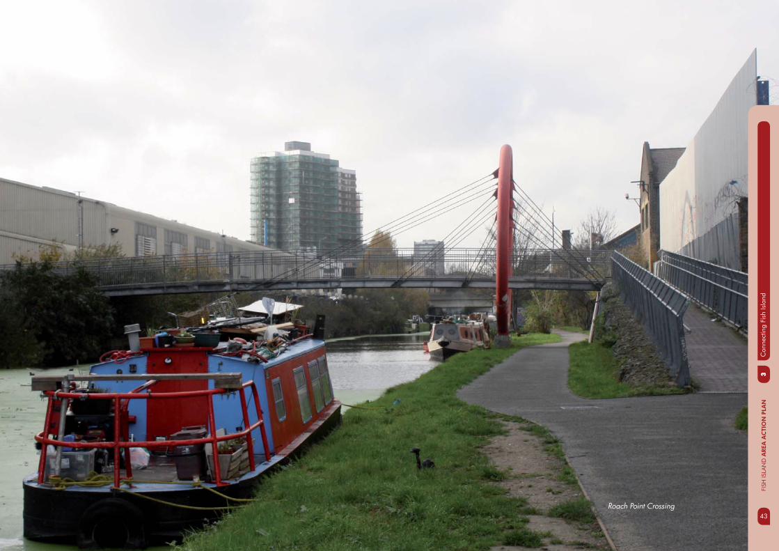
Figure 3.1b: Roach Point Crossing: Indirect connection from Hackney Wick Station
3.5 An integrated network of streets connecting the character areas of Fish Island would create better access to Hackney Wick Station and enhance the potential for regeneration with development linked to public transport.
3.6 Fish Island East will be developed with up to 900 new homes as part of the Olympic Legacy development. Connections across the Lea Navigation will be essential to ensure that future residents can integrate with existing communities, access job opportunities and get to services such as shops, schools and health facilities.
43
3C
onne
ctin
g Fi
sh Is
land
43
FISH
ISLA
ND
AREA
AC
TIO
N P
LAN
Roach Point Crossing
3C
onne
ctin
g Fi
sh Is
land
FISH
ISLA
ND
AREA
AC
TIO
N P
LAN
44
3.7 The issue of poor connectivity from Fish Island to surrounding areas has also been recognised in numerous documents and studies including our adopted Core Strategy. This is refl ected in its vision for Fish Island:
Connecting Fish Island will see improvements to the strategic and local movement network, making Fish Island an easier place to get to and move through. The creation of a joined up street pattern with new and improved bridges, an enhanced Greenway and tow paths will make Fish Island a more accessible place, on foot and bicycle, maximising connections to the Olympic Park and Stratford City.
3.8 The Core Strategy sets out three priorities for connections and transport serving Fish Island. These priorities have been incorporated in to the AAP to serve as guiding principles for the connectivity and transport requirements for development in Fish Island.
3.9 FI 3.1 provides a framework within the AAP to identify and prioritise interventions and policies to deliver connectivity and transport improvements that support the vision for Fish Island.
3.10 When considering proposed improvements it is important to note that Fish Island has the benefi t of being served by the Capital Ring and Lea Valley Walk strategic walking routes as well as the NCN+1 and LCN16 cycling routes. These strategic walking and cycling routes (shown on Figure 3.2) can provide a foundation on which improvements to key routes and local networks can be built.
3.11 The key routes that link the main centres of activity in Fish Island to each other, adjacent areas and public transport have been identifi ed are shown on Figure 3.2. Existing bus routes serving the area are shown in Figure 3.4.
3.12 Realising the key routes shown on Figure 3.2 will depend on a number of local infrastructure and public realm improvements. The options for new or enhanced connections are arranged by broad connectivity objective and together offer a comprehensive package of measures to deliver the Key Connectivity and Transport Principles.
AAP POLICY FI 3.1
KEY CONNECTIVITY AND TRANSPORT
PRINCIPLES
1. To signifi cantly improve strategic connections by overcoming the barrier of the A12, providing bridge connections across the waterways, enhancing the Greenway and creating new routes to the Olympic Legacy area.
2. To improve local connections by creating a street pattern that allows for ease of movement on foot or bicycle
3. To work with Transport for London and others to improve Hackney Wick transport hub and connections to it.

45
3C
onne
ctin
g Fi
sh Is
land
45
FISH
ISLA
ND
AREA
AC
TIO
N P
LAN
Figure 3.2: Connecting Fish Island
STRATFORDINTERNATIONAL
HACKNEY WICK
PUDDING MILL LANE
OLYMPICSTADIUM
VICTORIA PARK
STRATFORD

3C
onne
ctin
g Fi
sh Is
land
FISH
ISLA
ND
AREA
AC
TIO
N P
LAN
46
ACHIEVING CONNECTIVITY
OVERCOMING THE BARRIER OF THE A12
3.13 The A12 defi nes the western boundary of the ‘Island’, contributing to the area’s relative isolation from adjacent neighbourhoods to the west. Currently, fi ve crossing points, two of which cater for vehicular movements, provide access across the A12 into Fish Island. The existing connections across the A12 typically provide a poor and unwelcoming environment for pedestrians and cyclists.
3.14 The Engagement Version of the AAP included proposals for additional vehicle crossings across the A12 to Fish Island that received little support during public consultation. Improvements should instead focus on maximising the use of existing connections by ensuring they are effectively integrated into the wider walking and cycling networks on either side of the A12 and are themselves amenable to pedestrians and cyclists.
CONNECTIONS OVER THE WATERWAYS
3.15 The waterways of Fish Island offer the opportunity to create attractive walking and cycling routes along towpaths. The existing provision of crossings over these waterways does not suffi ciently connect areas where signifi cant residential and employment growth is expected to take place. Additional connections over the waterways are needed to support the anticipated levels of growth in Fish Island, improve access to services and public transport and ensure the Olympic Legacy is properly integrated.
AAP POLICY FI 3.2
PRIORITY ACTIONS TO IMPROVE
ACCESS ACROSS THE A12
IMPLEMENTATION
1. Upgrade of the existing pedestrian and cycle bridge over the A12 linking Old Ford Road to Crown Close with improved signage and public realm improvements on the landing site on Crown Close;
2. Signifi cant improvements to the pedestrian bridge over the A12 linking Victoria Park to Rothbury Road;
3. Improvements to create a safer and more attractive walking and cycling route on Wick Lane between Monier Road and Victoria Park;
4. Pedestrian and cycle crossing improvements at the junction of Tredegar Road and Wick lane with the A12.
A12 from Crown Close pedestrian bridge

47
3C
onne
ctin
g Fi
sh Is
land
47
FISH
ISLA
ND
AREA
AC
TIO
N P
LAN
3.16 Consideration of a new bridge across the River Lea at Autumn Street or Riverside Wharf to create a more direct route between Roman Road/Bow and Stratford will be given in the long term but will depend on the future of Bow Midland East rail yard in Newham.
ENHANCING THE GREENWAY
3.17 The Greenway forms part of a strategic east-west walking and cycling route that links Fish Island to destinations to the east. It also provides an important route to Pudding Mill Station, which offers rail access serving Fish Island Mid and Fish Island south.
3.18 Improving access from Fish Island onto the Greenway will encourage its use and reduce walking times between Fish Island and Pudding Mill Station.
AAP POLICY FI 3.3
PRIORITY ACTIONS TO IMPROVE
CONNECTIONS OVER THE WATERWAYS
AAP POLICY FI 3.4
PRIORITY ACTIONS TO ENHANCE
ACCESS TO THE GREENWAY
IMPLEMENTATION
1. A new all modes bridge over the Lea Navigation linking Monier Road to Fish Island East;
2. A new pedestrian and cycle bridge connecting the corner of Roach Road and Beachy Road to Fish Island East;
3. Improved connectivity over the Hertford Union Canal between Fish Island North and Fish Island Mid. (See section below titled ‘Improving Internal Connections’);
4. Re-opening and upgrading the all modes bridge at White Post Lane;
5. Modifi ed lock on Hertford Union Canal to create an additional crossing for pedestrians and cycles;
6. Environmental improvements to Wansbeck Road (including an upgrade of the bridge over the Hertford Union canal).
IMPLEMENTATION
1. Upgrade of the existing connection from Dace Road to the Greenway;
2. A new pedestrian/cycling connection from Wick Lane (between Crown Close and Riverside Wharf) to the Greenway;
3. A new pedestrian and cycle connection from Riverside Wharf to the Greenway bridge over the River Lea
The Greenway
3C
onne
ctin
g Fi
sh Is
land
FISH
ISLA
ND
AREA
AC
TIO
N P
LAN
48
CONNECTIONS WITHIN FISH ISLAND
3.19 Internal connections within Fish Island can be poor, with particular issues between the different character areas, largely caused by limited crossing points over the Hertford Union canal and Lea Navigation, the existing street layout and large industrial sites either side of the Hertford Union Canal.
3.20 Improved internal connections within Fish Island are needed to increase permeability, create new pedestrian and cycle routes, enhance access to public transport, shops and services and increase capacity for the intensifi cation of traffi c to support development and encourage sustainable travel.
AAP POLICY FI 3.5
PRIORITY ACTIONS TO IMPROVE INTERNAL
CONNECTIVITY IN FISH LSLAND
DEVELOPMENT MANAGEMENT
1. Development sites located between White Post Lane and Wyke Road will need to safeguard pedestrian and cycle routes to improve permeability and deliver key routes between the hub at Hackney Wick and Fish Island Mid.
IMPLEMENTATION
2. A new link between Fish Island North and Fish Island Mid to provide a more direct route between the hub at Hackney Wick and Fish Island Mid. Options for this connection include:
i. Upgrade of the Roach Point Bridge. The existing bridge is narrow and would be unable to accommodate a substantial intensifi cation of pedestrian and cycle traffi c. Upgrading of this bridge will be contingent on securing a direct route between Hackney Wick and Roach Point Bridge.
ii. An additional cycle and pedestrian crossing over the Hertford Union canal. This option is contingent on the availability of improved access to the bridge landing points north and south of the canal.
3. A new pedestrian and cycle underpass through the railway embankment to link the hub at Hackney Wick to White Post Lane. The link would facilitate a new station entrance on each side of the embankment.
49
3C
onne
ctin
g Fi
sh Is
land
49
FISH
ISLA
ND
AREA
AC
TIO
N P
LAN
3.21 The actions proposed in this chapter that could deliver improved connectivity within and across Fish Island are shown on Table 3.1 and Figure 3.3. Appendix 1 provides further detail on these interventions, identifying priorities and whether funding has been committed in full or part.
Option Proposal
1 Upgraded pedestrian/cycle connection over the A12 from Wallis Road to Cadogan Terrace
2 New pedestrian/ cycle underpass linking White Post Lane with the hub at Hackney Wick
3 New all modes route linking the footbridge north of Roach Road to White Post Lane and the hub at Hackney Wick, accessible by all modes except over the existing footbridge and railway underpass
4a New pedestrian and cycle route linking Wyke Road to Trego Road including new bridge over Hertford Union Canal
4b New pedestrian and cycle route and linking Wyke Road to Hepscott Road including new bridge over Hertford Union Canal
5 Upgraded pedestrian and cycling facilities at White Post Lane bridge
6 Upgraded pedestrian and cyclist link on Wick Lane from the Greenway to Victoria Park
7 New all modes vehicle bridge linking Monier Road to Fish Island East
8 New pedestrian and cycle bridge connecting the corner of Roach Road and Beachy Road to Fish Island East
9 Upgrading of Lea crossing at Bow Locks
10 Upgrade of existing pedestrian and cycle route at Crown Close
11 New pedestrian and cycle connection from Wick Lane to the Greenway
12 New pedestrian and cycle connection from Riverside Wharf/Wick Lane to the Greenway bridge over the River Lea
13 New bridge connection across the River Lea at Autumn Street or Riverside Wharf (Dependent on the future of Bow Midland East rail yard in Newham).
14 Upgraded pedestrian and cycling facilities at Wick Lane/ A12 junction
15 New north-south all modes route on Fish Island East linking Carpenters Road to Monier Road and Fish Island East to East Wick and the stadium.
16 New east west all modes connection on Fish Island East linking the proposed Monier Road bridge to a new north-south link
17 New east west all modes connection on Fish Island east linking White Post Lane toward Stratford
18 Upgraded pedestrian and cycle facilities at Wansbeck Road crossing
Table 3.1: Priority Options for Improved Connections

3C
onne
ctin
g Fi
sh Is
land
FISH
ISLA
ND
AREA
AC
TIO
N P
LAN
50
Figure 3.3: Priority options for key connections in Fish Island improved
Key
Fish Island Area Action Plan Boundary
A12
Existing connections
Upgraded connections
New connections
Waterw
orks River
City Mill River
Ha
ckn
ey C
ut
Hertford
Unio
n Canal
Rive
r Lee
Na
viga
tion
STRATFORDINTERNATIONAL
RAIL
A 12
BLACKWALL TUNNEL NORTHERN APPROACH
W
A 1
2
OLYMPICSTADIUM
VICTORIA PARK
EAST CROSS ROUTE
MUSV
STRATFORDINTERNATIONAL
HACKNEY WICK
PUDDING MILL LANE
ENERGYCENTRE
WICK LANE
MAVERTON ROAD
WHITE POST LANE
BEACHY ROAD
BR
EA
M S
TRE
ET
WYKE R
OAD
STOUR ROAD
DACE ROAD
SM
EE
D R
OA
D
HEPSC
OTT RO
AD
ICELAND ROAD
OLD FORD ROAD
STRATFORDCITY
ROMAN ROAD
15
17
16
74a
4b
2
11
12
13
1
18
3
6
10
14
9
5
8
STRATFORD
51
3C
onne
ctin
g Fi
sh Is
land
51
FISH
ISLA
ND
AREA
AC
TIO
N P
LAN
BETTER PUBLIC TRANSPORT
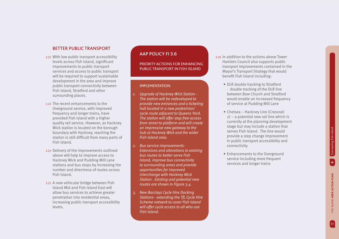
3.22 With low public transport accessibility levels across Fish Island, signifi cant improvements to public transport services and access to public transport will be required to support sustainable development in the area and improve public transport connectivity between Fish Island, Stratford and other surrounding places.
3.23 The recent enhancements to the Overground service, with improved frequency and longer trains, have provided Fish Island with a higher quality rail service. However, as Hackney Wick station is located on the borough boundary with Hackney, reaching the station is still diffi cult from many parts of Fish Island.
3.24 Delivery of the improvements outlined above will help to improve access to Hackney Wick and Pudding Mill Lane stations and bus stops by increasing the number and directness of routes across Fish Island.
3.25 A new vehicular bridge between Fish Island Mid and Fish Island East will allow bus services to achieve greater penetration into residential areas, increasing public transport accessibility levels.
AAP POLICY FI 3.6
PRIORITY ACTIONS FOR ENHANCING
PUBLIC TRANSPORT IN FISH ISLAND
IMPLEMENTATION
1. Upgrade of Hackney Wick Station - The station will be redeveloped to provide new entrances and a ticketing hall located in a new pedestrian/cycle route adjacent to Queens Yard. The station will offer step free access from street to platform and will create an impressive new gateway to the hub at Hackney Wick and the wider Fish Island area.
2. Bus service improvements- Extensions and alterations to existing bus routes to better serve Fish Island, improve bus connectivity to surrounding areas and provide opportunities for improved interchange with Hackney Wick Station . Existing and potential new routes are shown in Figure 3.4.
3. New Barclays Cycle Hire Docking Stations - extending the TfL Cycle Hire Scheme network to cover Fish Island will offer cycle access to all who use Fish Island.
3.26 In addition to the actions above Tower Hamlets Council also supports public transport improvements contained in the Mayor’s Transport Strategy that would benefi t Fish Island including:
DLR double tracking to Stratford • - double tracking of the DLR line between Bow Church and Stratford would enable an increased frequency of service at Pudding Mill Lane
Chelsea – Hackney Line (Crossrail • 2) – a potential new rail line which is currently at the planning development stage but may include a station that serves Fish Island. The line would provide a step change improvement in public transport accessibility and connectivity.
Enhancements to the Overground • service including more frequent services and longer trains

3C
onne
ctin
g Fi
sh Is
land
FISH
ISLA
ND
AREA
AC
TIO
N P
LAN
52
Figure 3.4: Existing and potential bus routes serving Fish Island
Key
Fish Island Area Action Plan Boundary
Bus route 8
Bus route 276
Bus route 488
Bus route 339
339 extension
262 extension
Potential routes for new/and or extended services
A12
Waterw
orks River
City Mill River
Ha
ckn
ey C
ut
Hertford
Unio
n Canal
Rive
r Lee
Na
viga
tion
STRATFORDINTERNATIONAL
RAIL
WICK LANE
MAVERTON ROAD
WHITE POST LANE
BEACHY ROAD
BR
EA
M S
TRE
ET
WYKE R
OAD
STOUR ROAD
DACE ROAD
SM
EE
D R
OA
D
HEPSC
OTT RO
AD
ICELAND ROAD
OLD FORD ROAD
488
276
339A
12
BLACKWALL TUNNEL NORTHERN APPROACH
W
A 1
2
OLYMPICSTADIUM
VICTORIA PARK
EAST CROSS ROUTE
MUSV
ENERGYCENTRE
STRATFORDINTERNATIONAL
HACKNEY WICK
PUDDING MILL LANE
WA
LLIS
RO
AD
BER
KS
HIR
E RO
AD
STRATFORDCITY
ROMAN ROAD
STRATFORD
53
4C
reat
ing
new
hom
es a
nd jo
bs
53
FISH
ISLA
ND
AREA
AC
TIO
N P
LAN
Opportunities for jobs and business
Creative industry and small businesses
Managing the release of industrial sites
New homes in Fish Island
Density and type of new housing
Affordable and family housing
Creating sustainable neighbourhoods
04SPATIAL THEMES
4C
reat
ing
new
hom
es a
nd jo
bsFI
SH IS
LAN
D A
REA
AC
TIO
N P
LAN
54
4.1 Fish Island is an area where business and industry have fl ourished since the 19th century. Old and modern industrial buildings and yards dominate the character of Fish Island today. Traditional industry such as printing, food processing and light manufacturing continue to exist but have been joined more recently by waste management, warehousing and storage. Estimates suggest that 3,000 jobs are accommodated in Fish Island and immediate surroundings (Tower Hamlets Spatial Economy Study).
4.2 Fish Island is also home to a fl ourishing creative arts community, which co-exists with complementary industries in particular the printing industry but also other businesses such as building material suppliers and some specialist creative arts businesses.
4.3 The whole of Fish Island (except the Olympic Legacy area, east of the Lea Navigation) is currently defi ned as Strategic Industrial Land (SIL), which has helped to maintain space for larger scale industries, but this has prevented other non-industrial uses from coming forward.
CREATING NEW HOMES AND JOBS
4.4 The Core Strategy seeks to ensure a managed approach to industrial land for the borough in order to assist in creating sustainable communities. This will be achieved by releasing between 30 and 50 ha of SIL up to 2025. There is an opportunity for the managed release SIL in Fish Island and to promote a more fl exible approach to land use to maximise the benefi ts of the Olympic Legacy, whilst retaining and intensifying a smaller area of SIL in Fish Island South.
4.5 New residential development will be appropriate in some areas supported by new and enhanced community facilities and infrastructure. The Core Strategy housing trajectory indicates that Fish Island could accommodate up to 2,400 new homes over the period to 2025, but notes that this fi gure will be confi rmed through the AAP process.
4.6 This section sets out proposals for introducing more fl exibility in planning policy to allow a balanced mix of uses to come forward and allow new homes to be delivered in conjunction with the managed release of existing industrial land, whilst maintaining space for existing businesses to stay in Fish Island and new ones to locate there. Fig 4.1 shows the overall land use planning strategy.
4.7 The AAP strategy for providing a balanced mix of uses will be:
Consolidate heavier industrial • activities in a new Strategic Industrial Location in Fish Island South;
Set out the opportunities for • redevelopment of sites in Fish Island Mid and North;
Set out an approach for promoting • and enhancing the cluster of creative industries in Fish Island Mid;
Provide space for existing businesses • that provide an important local function to remain;
Promote residential led development • in Fish Island East and Fish Island North and promote mixed uses along the main canal frontages in Fish Island Mid and Fish Island North.
Set out guidance for the location, • type and quantity of new residential development.

55
4C
reat
ing
new
hom
es a
nd jo
bs
55
FISH
ISLA
ND
AREA
AC
TIO
N P
LAN
Figure 4.1: Fish Island land use strategy
Key
Fish Island Area Action Plan Boundary
A12
Railway lines
The Greenway
Hackney Wick Hub (LB Tower Hamlets)
Hackney Wick Hub (LB Hackney)
Potential location for primary school
Focus for creative industries
Waterfront character predominantly green space
W
Mixed use regeneration
Residential led regeneration
Employment led regeneration
Local Industrial Location (LIL)
Strategic Industrial Location (SIL)
The Hub
Proposed Open Space
Potential location for secondary school
aterfront character predominantly residential character
Waterfront character industrial character
Waterw
orks River
City Mill River
Ha
ckn
ey C
ut
Hertford
Unio
n Canal
River Lee N
aviga
tion
A 12
BLACKWALL TUNNEL NORTHERN APPROACH
A 1
2
OLYMPICSTADIUM
VICTORIA PARK
EAST CROSS ROUTE
MUSV
ENERGYCENTRE
STRATFORDINTERNATIONAL
PUDDING MILL LANE
WA
LLIS
RO
AD
BER
KS
HIR
E RO
AD
OLD FORD ROAD
STRATFORD
Fish Island Mid
Heritage-led mixed use with residential regeneration on the
water fronts
Fish Island East
New residential community delivered through the Olympic
Legacy
Fish Island
South
Focus for employment and
industry
Fish Island
North
Mixed use employment and housing
regeneration around a neighbourhood centre
and transport hub.
STRATFORDINTERNATIONAL
RAIL
HACKNEY
WICK
STRATFORDCITY
ROMAN ROAD
STRATFORDINTERNATIONAL
4C
reat
ing
new
hom
es a
nd jo
bsFI
SH IS
LAN
D A
REA
AC
TIO
N P
LAN
56
OPPORTUNITIES FOR JOBS
AND BUSINESS
FISH ISLAND SOUTH - STRATEGIC
INDUSTRIAL LOCATION
4.8 The Core Strategy seeks to ensure “ a managed coordinated and phased regeneration programme and partial release of SIL in Fish Island to maximise the opportunities and benefi ts from the Olympic Legacy.” and “to retain Strategic Industrial Land for heavier industrial uses in the south of Fish Island.”
4.9 Some industrial activities benefi t from being clustered in one location to make use of existing strategic infrastructure or to minimise negative impacts on residents of other businesses.
4.10 Tower Hamlets Spatial Economy Study (2011) assesses the release of employment land for other uses, building on the conclusions of the previous Employment Land Study (2009). It concludes that substantially less land has been protected than envisaged by the ELS and substantially more land released for non industrial and employment uses.
4.11 Qualitative assessment carried out by the GLA shows that the areas south of the Greenway score well against criteria identifi ed for Strategic Industrial Locations. Sites south of Crown Close and Wick Lane score the highest. This analysis has been endorsed through the Employment Land Study which recommends a tightly drawn SIL boundary covering all Fish Island South up to the Greenway or restricting SIL to the area south of Crown Close and Wick Lane with the northern area retained as a Local Industrial Location.
4.12 To respond to the aims of the Core Strategy, the AAP proposes a new consolidated SIL in Fish Island South to maintain an appropriate supply of SIL for Tower Hamlets and London. The new SIL will be the area bounded by the A12, the Lea Navigation, Wick Lane and Crown Close. It will include the existing Bow Midland Rail Yard and industrial estates at Autumn Street and Iceland Road (fi g 4.2)

57
4C
reat
ing
new
hom
es a
nd jo
bs
57
FISH
ISLA
ND
AREA
AC
TIO
N P
LAN
Figure 4.2: Fish Island SIL boundary OS extract by LBTH
Key
Fish Island Area Action Plan Boundary
Strategic Industrial Land (SIL)
A12
Waterw
orks River
City Mill River
Ha
ckn
ey C
ut
Hertford
Unio
n Canal
STRATFORDINTERNATIONAL
RAIL
A 12
BLACKWALL TUNNEL NORTHERN APPROACH
A 1
2
OLYMPICSTADIUM
EAST CROSS ROUTE
MUSV
ENERGYCENTRE
STRATFORDINTERNATIONAL
HACKNEY WICK
PUDDING MILL LANE
WA
LLIS
RO
AD
BER
KS
HIR
E RO
AD
VICTORIA PARK
MAVERTON ROAD
WHITE POST LANE
BEACHY ROAD
BR
EA
M S
TRE
ET
WYKE R
OAD
STOUR ROAD
DACE ROAD
SM
EE
D R
OA
D
HEPSC
OTT RO
AD
OLD FORD ROAD
STRATFORDCITY
ROMAN ROAD
STRATFORD
4C
reat
ing
new
hom
es a
nd jo
bsFI
SH IS
LAN
D A
REA
AC
TIO
N P
LAN
58
4.13 Industrial uses in the retained SIL should be intensifi ed and sites promoted for development of high tech manufacturing, environmental industries, waste management and energy generation. These will support the emerging requirements of existing and new development in the area for industrial uses (falling mainly within class B2, B8), including high tech manufacturing, construction, waste management, freight, storage and logistics.
4.14 Improved access and environmental quality in Fish Island South, which will be a priority to make this a location of choice for high value modern manufacturing, technology and distribution businesses.
AAP POLICY FI 4.1
DEVELOPMENT MANAGEMENT
1. The area between the A12, Wick Lane, Crown Close, Autumn Street and the River Lea will be designated as Strategic Industrial Location (SIL). The boundary of SIL is shown on fi g 4.2.
2. Within the proposed SIL, land will be promoted and safeguarded for employment and industrial uses falling mainly within use classes B1(c), B2 and B8 as set out in the London Plan, the Industrial Capacity (London Plan) SPG 2008 and Tower Hamlets Core Strategy.
3. Provision of small scale “walk to” amenities such as crèches, cafes, and small local shops that serve the needs of people working in the industrial area and the occupiers of the adjacent live work accommodation on Wick Lane will be supported in line with the Industrial Capacity (London Plan) SPG.
IMPLEMENTATION
Prepare detailed design guidance for the SIL to show how sites can be redeveloped to provide a range of different types of industrial premises to meet local and London wide demand.
Work with partners and the GLA to develop a regeneration and investment strategy for Fish Island SIL to encourage the redevelopment and enhance the offer as a competitive location attractive to modern industry

59
4C
reat
ing
new
hom
es a
nd jo
bs
59
FISH
ISLA
ND
AREA
AC
TIO
N P
LAN
LOCAL INDUSTRIAL LOCATION
4.15 The area north of Wick Lane between the proposed SIL and the Greenway will be more transitional in character. Heavier industrial uses would not be appropriate in this location due to the potential environmental and amenity impacts on the Greenway as a strategic pedestrian route and the existing live-work developments.
4.16 Promoting smaller scale industrial uses and fl exible space for small businesses in the area north of Wick Lane will provide a suitable transition between the more intensively used industrial area and the more mixed character of Fish Island Mid. This will be achieved by releasing the SIL and designating this area as a Local Industrial Location (LIL). The policies in the Core Strategy and draft Managing Development DPD will apply here. The boundary of the proposed SIL and LIL in Fish Island South is shown on fi g 4.3. There will be opportunities for intensifi cation of industrial and employment uses within the LIL, but the starting principle will be no net loss of employment fl oor space.
Figure 4.3: Fish Island LIL boundary on OS extract by LBTH
Key
Fish Island Area Action Plan Boundary
Local Industrial Location (LIL)
A12
Waterw
orks River
City Mill River
Ha
ckn
ey C
ut
Hertford
Unio
n Canal
Rive
r Lee
Na
viga
tion
STRATFORDINTERNATIONAL
RAIL
A 12
BLACKWALL TUNNEL NORTHERN APPROACH
A 1
2
OLYMPICSTADIUM
VICTORIA PARK
EAST CROSS ROUTE
MUSV
ENERGYCENTRE
STRATFORDINTERNATIONAL
HACKNEY WICK
PUDDING MILL LANE
WA
LLIS
RO
AD
BER
KS
HIR
E RO
AD
WICK LANE
MAVERTON ROAD
WHITE POST LANE
BEACHY ROAD
BR
EA
M S
TRE
ET
WYKE R
OAD
STOUR ROAD
DACE ROAD
SM
EE
D R
OA
D
HEPSC
OTT RO
AD
OLD FORD ROAD
STRATFORDCITY
ROMAN ROAD
STRATFORD

4C
reat
ing
new
hom
es a
nd jo
bsFI
SH IS
LAN
D A
REA
AC
TIO
N P
LAN
60
AAP POLICY FI 4.2
DEVELOPMENT MANAGEMENT
1. Development resulting in the net loss of industrial fl oor space within Fish Island LIL will not be supported.
2. The redevelopment of sites with existing industrial (class B1 (b & c) or B2) fl oor space to include residential uses will only be supported if the existing industrial fl oor space is re-provided on site and the criteria in draft Managing Development policy DM17 are met
FISH ISLAND NORTH AND HACKNEY
WICK HUB
4.17 The Core Strategy states that a mix of uses including commercial, retail, leisure, work spaces and residential will be set around an improved public transport hub and neighbourhood centre at Hackney Wick.
4.18 Hackney Wick Hub has the potential to provide a variety of employment opportunities in Fish Island as part of the vision to create a neighbourhood centre to focus activity around the station and a distinctive gateway to and from Fish Island. Concentration of employment activity at Hackney Wick would help to deliver the Core Strategy objective of delivering successful employment hubs, concentrated in locations with good access to public transport.
4.19 There will be opportunities to exploit the proximity of Hackney Wick to the International Broadcast Centre/Main Press Centre which may come forward as fl exible business space for the ‘Creative Media City’ concept after the Olympic Games.
4.20 Employment space in the Hub and Fish Island North will be delivered by:
Removing the existing SIL designation; •
Allowing a broader mix of more • intensive and high value employment uses to come forward as part of mixed use development within the Hub core area
Promoting fl exible work space for small • and medium enterprises including creative industries, media and information technology;
Focussing on employment fl oor space • that is compatible with residential use and a high quality environment such as offi ces, studios, small scale light industrial (use classes B1(a), (b) and (c).

61
4C
reat
ing
new
hom
es a
nd jo
bs
61
FISH
ISLA
ND
AREA
AC
TIO
N P
LAN
EMPLOYMENT AND MIXED USE IN FISH
ISLAND MID
4.21 The Core Strategy states that Fish Island Mid will “prosper through conservation and heritage led renewal that will promote a mix of uses including new residential, workshops, creative and cultural industries, studios and light industry.
4.22 Fish Island Mid is an economically active area that is home to numerous businesses that support the local economy in Tower Hamlets. Fish Island is well placed as a location for fi rms needing quick and effi cient access to service the major employment centres of Canary Wharf and the City.
4.23 There is potential to build on the existing cluster of creative industries within the Conservation Area buildings by focussing on heritage-led regeneration. There is a synergy between the industrial character of Fish Island Conservation Area and the re-use of older buildings for fl exible and affordable workspace. This clustering of small scale creative businesses helps to create a unique character for Fish Island which could be exploited as regeneration takes place. Conservation Area management policies could be used to help address the tension between rising land values driven by the Olympic Legacy investment and the need for fl exible and affordable workspace.
4.24 Within Fish Island Mid three broad sub areas can be identifi ed in terms of character and location:
1. Sites along the Lea Navigation and Hertford Union Canal waterfronts;
2. Post war industrial sites adjacent to the A12 road
3. The concentration of older industrial buildings within Fish Island Conservation Area;
4.25 Sites along the canal frontages benefi t from good outlook, amenity and environmental improvements associated with the Olympic Legacy development. Improvements to the towpaths will provide good pedestrian and cycle access. These sites are further from main roads and have poorer vehicular access and so are less suited to modern industrial requirements. Waterfront sites such as Neptune Wharf and former warehouses on Bream Street will be suitable for predominantly residential development with active uses fronting the waterway, and associated supporting social and physical infrastructure.
4.26 Sites close to the A12, west of Smeed Road benefi t from good vehicular access which is essential for servicing requirements of modern light industrial uses. The environment here is affected by road noise and vibration and so less suited to residential use. The AAP proposes to safeguard this area for employment-led development through the designation of a new Local Industrial Location.
4.27 The area between Smeed Road, Wyke Road, Roach Road, Bream Street and the Greenway, which includes Fish Island Conservation Area includes a number of small scale light industrial uses and is home to a cluster of creative and cultural industries. This area will need to play an important role as a transitional zone between the mainly residential focus adjacent to the waterways and the more industrial character south of the Greenway and westwards towards the A12.

4C
reat
ing
new
hom
es a
nd jo
bsFI
SH IS
LAN
D A
REA
AC
TIO
N P
LAN
62
CREATIVE INDUSTRY AND SMALL
BUSINESSES
4.28 Over the last several decades, London’s creative sector has spread eastwards, and Hackney Wick and Fish island is at the heart of a range of signifi cant creative and cultural economic activity, with substantial new areas of space coming forward in the Lower Lea Valley.
4.29 Creative and cultural industries (CCIs) are defi ned by the Department for Culture, Media and Sport (DCMS) as:
“...those industries which have their origin in individual creativity, skill and talent which have a potential for job and wealth creation through the generation and exploitation of intellectual property” (‘Creative Industries Mapping Document’, DCMS, 2001).
The standard defi nition of the creative industries used by the DCMS includes 13 industries, including, advertising; architecture; art and antiques; crafts; design; designer fashion; fi lm and video; music and publishing.
4.30 It is widely recognised that London’s CCIs are both a driver and a consequence of its broader economic success. Tower Hamlets has the second highest (following Hackney with the highest) number of artists’ studios and groups, with 28% of all of London’s artists’ studio buildings and 43% of units (Mayor’s Cultural Strategy 2010). The concentration of CCIs and small businesses in Hackney Wick and Fish island plays a central part in the future evolution of the vision for the area.
4.31 Due to the defi nition and nature of these businesses, there is a lack of data and information provided by offi cial statistics to capture CCIs activity accurately. A mapping audit exercise undertaken by the London Development Agency (LDA), (dated 2009) identifi ed 610 studios (including live/work) across the Hackney Wick and Fish Island area. The studio spaces are not only occupied by creative practitioners such as designers, artists & galleries but also by a variety of supporting businesses from printers to fi nancial consultants.
4.32 The Olympic Legacy International Broadcasting Centre and Main Press Centre (IBC/MPC), in the London Borough of Hackney, will provide substantial new employment space, which could be occupied by large scale creative media, broadcasting, digital and related uses. Capitalising and nurturing the eastward shift of CCIs is of high importance for Hackney Wick and Fish island. There is now the opportunity to support, enhance and grow this economic activity, to create an area of international signifi cance. Building on the existing economic assets in Hackney Wick and Fish island, could attract media businesses to the IBC/MPC, which value the close proximity to the existing CCIs and small businesses for idea’s and innovation.
63
4C
reat
ing
new
hom
es a
nd jo
bs
63
FISH
ISLA
ND
AREA
AC
TIO
N P
LAN
4.33 CCIs create local job opportunities, in particular start-up space for Small Medium Enterprises (SMEs) or the self employed, but also contribute towards place making and the area’s distinct character. Many of Fish Island’s historical buildings, which are no longer suitable for traditional industrial activity have been adapted to create workspace for CCIs and other small businesses, which have encouraged this sector to fl ourish and grow in and around the Fish Island Conservation Area and Hackney Wick Station. The reuse of existing buildings, new developments and utilising space for active uses, will promote heritage-led renewal. This approach would support and enhance the character of the Fish Island Conservation Area and Locally Listed Buildings, to avoid the loss of existing fl exible workspaces spaces through new large scale developments.
4.34 There is evidence of a demand for further fl exible affordable workspaces in the area, as the waiting list for managed workspace continues to grow. Given the area’s location and redevelopment opportunities, the existing CCIs are challenged with signifi cant pressure for other land uses, which provide higher land value returns. It is of high importance for Fish Island to protect and promote CCIs and small businesses, to drive regeneration and ensure an appropriate balance is established and introduced in the area (in particular Old Ford Conservation Area and Hackney Wick Station), to achieve a mix of uses that add vibrancy to the area.
4.35 Developers will be encouraged to retain existing and to provide new employment uses and spaces, with a particular focus on fl exible managed workspaces for CCIs and SMEs, through the redevelopment of existing or new buildings. Developers will also be encouraged to enter into discussions with managed workspace providers in order to ascertain local employment needs for any particular development opportunity. Workspace providers can play a signifi cant role in the management and maintenance of employment spaces as part of a mix use developments.
AAP POLICY FI 4.3
DEVELOPMENT MANAGEMENT
1 The re-use, refurbishment and conversion of older industrial buildings within Fish Island Conservation Area, proposed White Post Lane Conservation Area and proposed locally Listed Buildings, for fl exible and managed workspaces, suitable for small businesses and creative industries will be encouraged.
2 New development opportunities should include fl exible employment fl oor space suitable for occupation by SMEs in accordance with guidance set out in appendix2 of the AAP and policies FI4.1 and FI4.2. New development should include a proportion of employment fl oor space provided at below market rents to attract new and start up businesses.

4C
reat
ing
new
hom
es a
nd jo
bsFI
SH IS
LAN
D A
REA
AC
TIO
N P
LAN
64
MANAGING THE RELEASE OF
INDUSTRIAL SITES
4.36 The sections above explain how existing land use policies could be altered to achieve a better balance of uses across Fish Island by consolidating the Strategic Industrial Location in Fish Island South, designating a Local Industrial Location in parts of Fish Island Mid and Fish Island South and promoting the existing clusters of Creative industries and small businesses.
4.37 Managing the release of existing industrial and employment sites for mixed use development across the whole of Fish Island outside of the Strategic and Local Industrial Locations and the Legacy development area will be achieved through the statutory development management process. The spatial approach set out above will be complimented with clear criteria that will be used to assess proposals for redevelopment.
AAP POLICY FI 4.4
DEVELOPMENT MANAGEMENT
1. Proposals for redevelopment of existing industrial sites outside of the SIL and LIL, for mixed use including residential will be considered favourably if they meet the following criteria:
The proposals would maintain or • increase employment density - i.e. more jobs would be created) when compared with the existing or last permitted use of the site;
The proposals would retain • and / or refurbishes heritage assets including buildings within Fish Island Conservation Area and Buildings of townscape merit;
The proposal would provide • improved connections and / or enhanced public realm that would help to deliver the AAP vision;
A re-location strategy for • existing businesses affected by the redevelopment has been provided;
The development would provide • or contribute to the social and community facilities required to support new housing development;
Proposals for mixed use • development that include housing would not result in any signifi cant confl ict between employment and residential uses (including those on adjacent sites);
Proposals would include fl exible • workspace for small and medium enterprises and/or creative industries.
65
4C
reat
ing
new
hom
es a
nd jo
bs
65
FISH
ISLA
ND
AREA
AC
TIO
N P
LAN
NEW HOMES IN FISH ISLAND
4.38 Residential development will be appropriate in Fish Island outside of the proposed SIL designation in order to create a mixed-use environment alongside other uses including employment and commercial and retail development, supported by local services and community facilities.
4.39 Initial work suggests that through careful planning and innovative design, new development could deliver up to 2,800 new homes across Fish Island, including a signifi cant proportion of affordable and family housing, in line with core strategy and development management policies.
4.40 The provision of facilities such as schools, health facilities and open space will be essential to support the development of Fish Island alongside housing and other uses.
4.41 Fish Island is well placed to take advantage of Victoria Park and the Queen Elizabeth Olympic Park, subject to establishing good connections between these open spaces and the residential communities in Fish Island. In addition to this, evidence suggests (through the Tower Hamlets Open Space Strategy) that there is also a requirement to provide access to more local open spaces close to homes, so that there is a choice of different types of open space available from play areas through to sporting activities. To achieve this, the AAP will need to identify opportunities for smaller open spaces to come forward as sites are re-developed. Further detail on the provision of new open space in Fish Island is provided in Section 6.
FISH ISLAND NORTH
4.42 Good public transport access through the redevelopment of Hackney Wick Station and proximity to the emerging hub at Hackney Wick means that Fish Island North will be one of the key areas of change and see signifi cant levels of residential development coming forward over the lifetime of the AAP.
4.43 Residential development in Fish Island North will include both new homes and the re-use of existing buildings, all of which should respond to the character and setting of the area. The main opportunities for new homes in Fish Island North will be through the redevelopment of sites close to Hackney Wick Station for mixed use development and the comprehensive development of the larger sites adjacent to Hertford Union Canal.
4C
reat
ing
new
hom
es a
nd jo
bsFI
SH IS
LAN
D A
REA
AC
TIO
N P
LAN
66
4.44 Residential development in Fish Island North should protect, enhance and respond to the character, setting, scale and urban grain of the area; through both the creative and adaptive reuse of existing historic buildings and well designed modern buildings. The proposed White Post Lane Conservation Area will provide additional guidance as to how new development is integrated within the historic environment and heritage assets along White Post Lane.
FISH ISLAND MID
4.45 Residential development is seen as an important part of the vision for Fish Island Mid including family housing and residential development as part of mixed-use developments, where housing can add value to waterside locations. Residential development must also respond to the character appraisal and management guidelines within the Fish Island Conservation Area policies.
4.46 The main opportunities for residential development in Fish Island Mid will be on sites fronting the Hertford Union Canal and Lea Navigation and through the comprehensive redevelopment of large scale sites such as Neptune Wharf.
FISH ISLAND EAST
4.47 Fish Island East will undergo comprehensive redevelopment as part of the Olympic Legacy development proposals. Fish Island East will become a new residential neighbourhood that will include a range of house types with a focus on higher amounts of family housing and provision of substantial affordable housing. There is an opportunity in Fish Island East to create a brand new high quality residential neighbourhood in a high quality environment using innovative design that responds to the positive characteristics of adjoining parts of Fish Island and the Olympic Park.
4.48 New physical and social infrastructure will need to be provided for new and existing residents, which includes new primary or secondary school provision, local open space, and community provision. Improved connections to neighbouring areas (as described in the connectivity section) will ensure the new communities on Fish Island East become integrated with existing communities in Tower Hamlets and that community facilities provided here can be used by people living outside the immediate area.
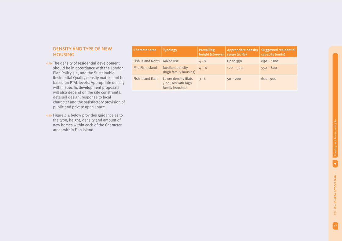
67
4C
reat
ing
new
hom
es a
nd jo
bs
67
FISH
ISLA
ND
AREA
AC
TIO
N P
LAN
DENSITY AND TYPE OF NEW
HOUSING
4.49 The density of residential development should be in accordance with the London Plan Policy 3.4, and the Sustainable Residential Quality density matrix, and be based on PTAL levels. Appropriate density within specifi c development proposals will also depend on the site constraints, detailed design, response to local character and the satisfactory provision of public and private open space.
4.50 Figure 4.4 below provides guidance as to the type, height, density and amount of new homes within each of the Character areas within Fish Island.
Character area Typology Prevailing height (storeys)
Appropriate density range (u/Ha)
Suggested residential capacity (units)
Fish Island North Mixed use 4 - 8 Up to 350 850 – 1100
Mid Fish Island Medium density (high family housing)
4 – 6 120 – 300 550 – 800
Fish Island East Lower density (fl ats / houses with high family housing)
3 - 6 50 – 200 600 - 900

4C
reat
ing
new
hom
es a
nd jo
bsFI
SH IS
LAN
D A
REA
AC
TIO
N P
LAN
68
AFFORDABLE AND FAMILY
HOUSING
4.51 New housing coming forward in Fish Island will need to meet a range of different housing needs. The provision of affordable housing is a key priority for Tower Hamlets. The Core Strategy sets an overall target of 50% affordable housing across the borough. This will be achieved by seeking at least 35% affordable housing as a component of any residential development. There are signifi cant opportunities for sites subject to redevelopment to contribute towards meeting the Borough’s overall affordable housing needs through the provision of on-site affordable housing.
AAP POLICIES FI 4.5
DEVELOPMENT MANAGEMENT
1. Development proposals including 10 or more new homes must provide a minimum of 35% affordable housing as set out in Tower Hamlets Core Stratregy and the draft Managing Development DPD.
2. Affordable housing should be split between intermediate (30%) and social rent (70%). Affordable rented accommodation (as defi ned in PPS3) will only be acceptable where social rented accommodation would render the proposals unviable.
3. Housing should provide for a range of house types and sizes in accordance with guidance set out on Tower Hamlets Core Strategy, draft Managing Development DPD, Interim Planning Guidance and the Mayor of London’s Housing SPG.
4.52 There is also substantial demand for family housing (homes with three or more bedrooms) across Tower Hamlets. Development in Fish Island has the potential to contribute to the provision of family accommodation with access to high quality environment, amenities such as green space, public transport, leisure and sports facilities. The Mayor of London has stated that homes for families will be signifi cant focus of the Olympic Legacy development. This is confi rmed in the draft Olympic Legacy SPG.
69
4C
reat
ing
new
hom
es a
nd jo
bs
69
FISH
ISLA
ND
AREA
AC
TIO
N P
LAN
CREATING SUSTAINABLE
NEIGHBOURHOODS
4.53 Housing growth in Fish Island will need to come forward with appropriate supporting infrastructure to ensure the creation of sustainable neighbourhoods. The Core Strategy and Infrastructure Delivery Plan identify areas of search for new primary and secondary schools and a primary care health facility to support anticipated housing growth in Fish Island and also to support wider demands in Tower Hamlets..
EDUCATION
4.54 Suffi cient school places will need to be provided within Fish Island to meet the demand for places arising from residential development including the Olympic Legacy development.
4.55 The Core Strategy identifi ed Fish Island as an area of search for both new Secondary and Primary Schools to support anticipated housing growth in Fish Island and also to support demand for additional school places arising from growth across Tower Hamlets. The principles that underpin the Olympic Legacy objective of “convergence” support the provision of new schools and high quality education for children from both existing and new communities in and around Fish Island and the Olympic fringe.
4.56 Primary school places will be provided in either one or two primary schools within Fish Island and potentially one secondary school, subject to the amount of development being proposed. A joint approach with adjoining boroughs, OPLC and the GLA will be needed to understand the most appropriate strategy for providing primary and seondary school places across Fish Island and Hackney Wick.
4.57 The Council’s projections identify the need for two additional secondary schools to be provided within Tower Hamlets during the LDF plan period to 2025. This is over and above the increase in capacity secured through the expansion of existing schools under the Council’s Building Schools for the Future programme and takes into account the need to re-provide the four forms of entry currently provided by Bow Boys School which is not considered fi t for purpose to remain as a secondary school. This demand has been verifi ed by the GLA’s own Pupil Place Planning Projection fi gures. Hackney Council has also identifi ed a need for additional secondary school places, in the East of its Borough.
4.58 The Council has identifi ed the Bow Lock site to provide the fi rst of these new schools, with the aim of a new nine form entry school opening by 2014. This will accommodate the 4 forms of entry from Bow Boys School and provide a further fi ve forms of additional capacity. A further site would be required to deliver a second school by 2018 with the demand arising from the East of the Borough.
4.59 Following the assessment of a number of sites on Fish Island North and Fish Island Mid, there is no single site west of the Lea Navigation large enough to deliver a secondary school, and there are considerable risks attached to the fi nancial viability and deliverability of assembling a site through CPO processes. A primary school site alongside other forms of development potentially as part of a mixed use development in Fish Island Mid, is considered deliverable.
4.60 Comprehensive redevelopment of Fish Island East provides an opportunity to deliver a secondary school as part of a wider residential led development, particularly as this area is under the single ownership of the OPLC. This would be in a suitable location to help meet demand arising in eastern parts of Hackney.
4C
reat
ing
new
hom
es a
nd jo
bsFI
SH IS
LAN
D A
REA
AC
TIO
N P
LAN
70
AAP POLICIES FI 4.6 AAP POLICY FI 4.7
DEVELOPMENT MANAGEMENT
1. Residential development in Fish Island should contribute to the provision of additional school places in accordance with the Tower Hamlets Core Strategy and draft Planning Obligations SPD.
IMPLEMENTATION
2. Work with OPLC to identify an appropriate site and delivery mechanism to provide a six form entry secondary school (1.5 ha approx) within Fish Island East as part of the comprehensive legacy development.
3. Work with land owners in Fish Island Mid to safeguard a site for the provision of a three form entry primary school (0.5 ha approx) as part of the future comprehensive development of site(s) adjacent to the Hertford Union canal.
DEVELOPMENT MANAGEMENT
1. Residential development in Fish Island should contribute towards the provision of health care facilities in accordance with Tower Hamlets Core Strategy and the draft planning obligations SPD.
IMPLEMENTATION
2. Work with partners and land owners to provide a suitable location, as part of a mixed-use development or a stand-alone facility, for new primary care facility (4 GPs – TBC) within the Hackney Wick Neighbourhood Centre
HEALTH CARE
4.61 All homes within Fish Island should have access to a primary health care facility which is located in an accessible location with good access via public transport. The focus of activity in the Hub at Hackney Wick will provide opportunities for a range of community facilities including primary health care facilities such as GP surgeries, clinics, dental practices and walk in centres.

71
5A
hub
at H
ackn
ey W
ick
71
FISH
ISLA
ND
AREA
AC
TIO
N P
LAN
Role and function of the Hub
Defi ning a core for the Hub
Hackney Wick Station improvements
Connecting the Hub to the wider area
Introducing retail and other town centre uses
05SPATIAL THEMES
5A
hub
at H
ackn
ey W
ick
FISH
ISLA
ND
AREA
AC
TIO
N P
LAN
72
5.1 The area around Hackney Wick Station has been identifi ed in Tower Hamlets Core Strategy and the draft OLSPG as an opportunity to deliver a new neighbourhood centre. The Hackney Wick area will offer a range of shops and services in a unique setting, focussed on improved transport links and connections at Hackney Wick Station.
A HUB AT HACKNEY WICK
5.2 Hackney Wick will become a Hub, providing access to local shops, services, leisure and community facilities to support growth and regeneration in the wider Fish Island and Hackney Wick area. The Hub also represents a unique opportunity to support and enhance creative industries in the Fish Island and Hackney Wick area. These industries will play a signifi cant role in the delivery of an active employment hub for micro and small businesses, as well as a vibrant retail hub, which together will provide a mix of services to support the local community.
5.3 The area included in the Hub will straddle the boundaries between Tower Hamlets and Hackney, to focus activity either side of Hackney Wick Station. Enhanced public realm, a proposed connection beneath the railway viaduct and improvements to Hackney Wick Station will ensure the two parts of the Hub are joined up.
5.4 High quality new architecture will complement the reuse of existing buildings and create a mixed use environment with innovative approaches to incorporating employment and residential uses within developments. The Hub will undergo mixed-use, heritage-led regeneration to form part of the aspirations to connect to the area to the wider Hackney Wick area in London Borough of Hackney.

73
5A
hub
at H
ackn
ey W
ick
73
FISH
ISLA
ND
AREA
AC
TIO
N P
LAN
ROLE AND FUNCTION
OF THE HUB
5.5 The Hub is in close proximity to other major retail town centres, such as Roman Road and Westfi eld Stratford City, which provide local residents with retail comparison products, such as clothes and household goods. The Hub will complement these major town centres, and offer a different shopping experience by providing a range of shops and unit sizes, to access day-to-day convenience goods that serve the local catchment area, accessible by walking and cycling. It will also differentiate itself, by providing a range of employment spaces, particular in the creative and cultural sector, enabling start up micro and small businesses to develop and pool resources in the local area, where appropriate.
5.6 The Hub will act as a gateway to the Hackney Wick and Fish Island area, as well as the future Queen Elizabeth park and associated Olympic legacy facilities. Activity will be along key routes towards the station, which will create a network of interconnected routes and spaces of activity and uses. There is also an opportunity to capitalise on the visitor economy offer from Westfi eld Stratford City, the Olympic Legacy facilities and associated events. As such, potential uses in the Hub will provide a mix of uses, which could also serve the visitor economy.
5.7 The overarching principles, for the Hackney Wick Hub are:
Ensure a coordinated approach to • development of the Hub either side of the railway line and borough boundary.
A Hub of employment and retail activity, • that builds on the character and ‘unique selling point’ of Hackney Wick and Fish Island to defi ne a neighbourhood centre that complements (rather than competes with) existing town centres, such as Roman Road and Stratford City;
Heritage led renewal which builds on • the unique character and heritage across the area through innovative and creative principles.
A Hub that integrates well with it • surroundings and enhances routes to, from and within the neighbourhood centre to the wider Fish Island and Hackney Wick area and to the Olympic Park.
A coordinated approach to the, development of the Hub area station improvements, either side of the railway line and borough boundary, including the creation of a station square and new links to join the two parts of the Hub either side of the railway.
Covent GardenBrick Lane
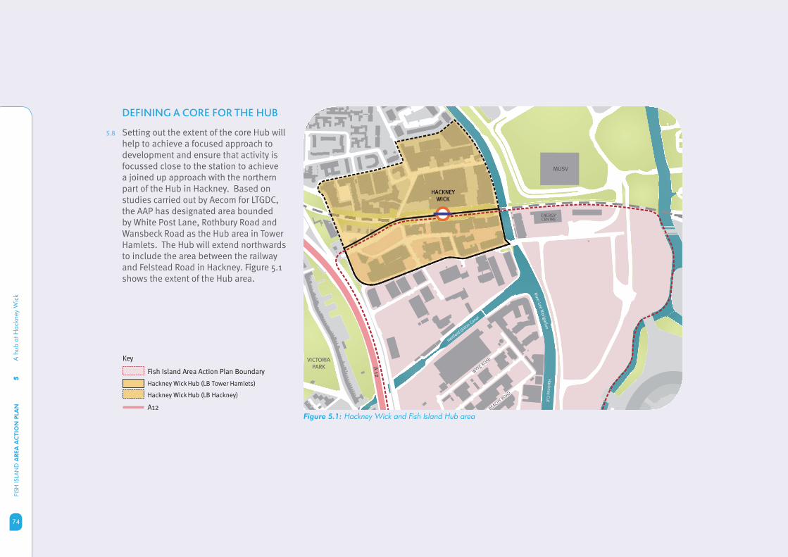
5A
hub
at H
ackn
ey W
ick
FISH
ISLA
ND
AREA
AC
TIO
N P
LAN
74
Figure 5.1: Hackney Wick and Fish Island Hub area
DEFINING A CORE FOR THE HUB
5.8 Setting out the extent of the core Hub will help to achieve a focused approach to development and ensure that activity is focussed close to the station to achieve a joined up approach with the northern part of the Hub in Hackney. Based on studies carried out by Aecom for LTGDC, the AAP has designated area bounded by White Post Lane, Rothbury Road and Wansbeck Road as the Hub area in Tower Hamlets. The Hub will extend northwards to include the area between the railway and Felstead Road in Hackney. Figure 5.1 shows the extent of the Hub area.
Ha
ckn
ey C
ut
Hertford
Unio
n Canal
Rive
r Lee
Na
viga
tion
A 1
2BEACHY R
OAD
WYKE R
OAD
HACKNEY
WICK
VICTORIA PARK
MUSV
ENERGYCENTRE
Key
Fish Island Area Action Plan Boundary
Hackney Wick Hub (LB Tower Hamlets)
Hackney Wick Hub (LB Hackney)
A12
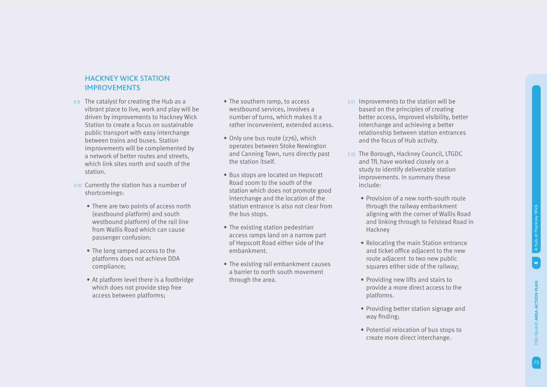
75
5A
hub
at H
ackn
ey W
ick
75
FISH
ISLA
ND
AREA
AC
TIO
N P
LAN
HACKNEY WICK STATION
IMPROVEMENTS
5.9 The catalyst for creating the Hub as a vibrant place to live, work and play will be driven by improvements to Hackney Wick Station to create a focus on sustainable public transport with easy interchange between trains and buses. Station improvements will be complemented by a network of better routes and streets, which link sites north and south of the station.
5.10 Currently the station has a number of shortcomings:
There are two points of access north • (eastbound platform) and south westbound platform) of the rail line from Wallis Road which can cause passenger confusion;
The long ramped access to the • platforms does not achieve DDA compliance;
At platform level there is a footbridge • which does not provide step free access between platforms;
The southern ramp, to access • westbound services, involves a number of turns, which makes it a rather inconvenient, extended access.
Only one bus route (276), which • operates between Stoke Newington and Canning Town, runs directly past the station itself.
Bus stops are located on Hepscott • Road 100m to the south of the station which does not promote good interchange and the location of the station entrance is also not clear from the bus stops.
The existing station pedestrian • access ramps land on a narrow part of Hepscott Road either side of the embankment.
The existing rail embankment causes • a barrier to north south movement through the area.
5.11 Improvements to the station will be based on the principles of creating better access, improved visibility, better interchange and achieving a better relationship between station entrances and the focus of Hub activity.
5.12 The Borough, Hackney Council, LTGDC and TfL have worked closely on a study to identify deliverable station improvements. In summary these include:
Provision of a new north-south route • through the railway embankment aligning with the corner of Wallis Road and linking through to Felstead Road in Hackney
Relocating the main Station entrance • and ticket offi ce adjacent to the new route adjacent to two new public squares either side of the railway;
Providing new lifts and stairs to • provide a more direct access to the platforms.
Providing better station signage and • way fi nding;
Potential relocation of bus stops to • create more direct interchange.

5A
hub
at H
ackn
ey W
ick
FISH
ISLA
ND
AREA
AC
TIO
N P
LAN
76
Figure 5.2: Conceptual image of Hackney Wick Station
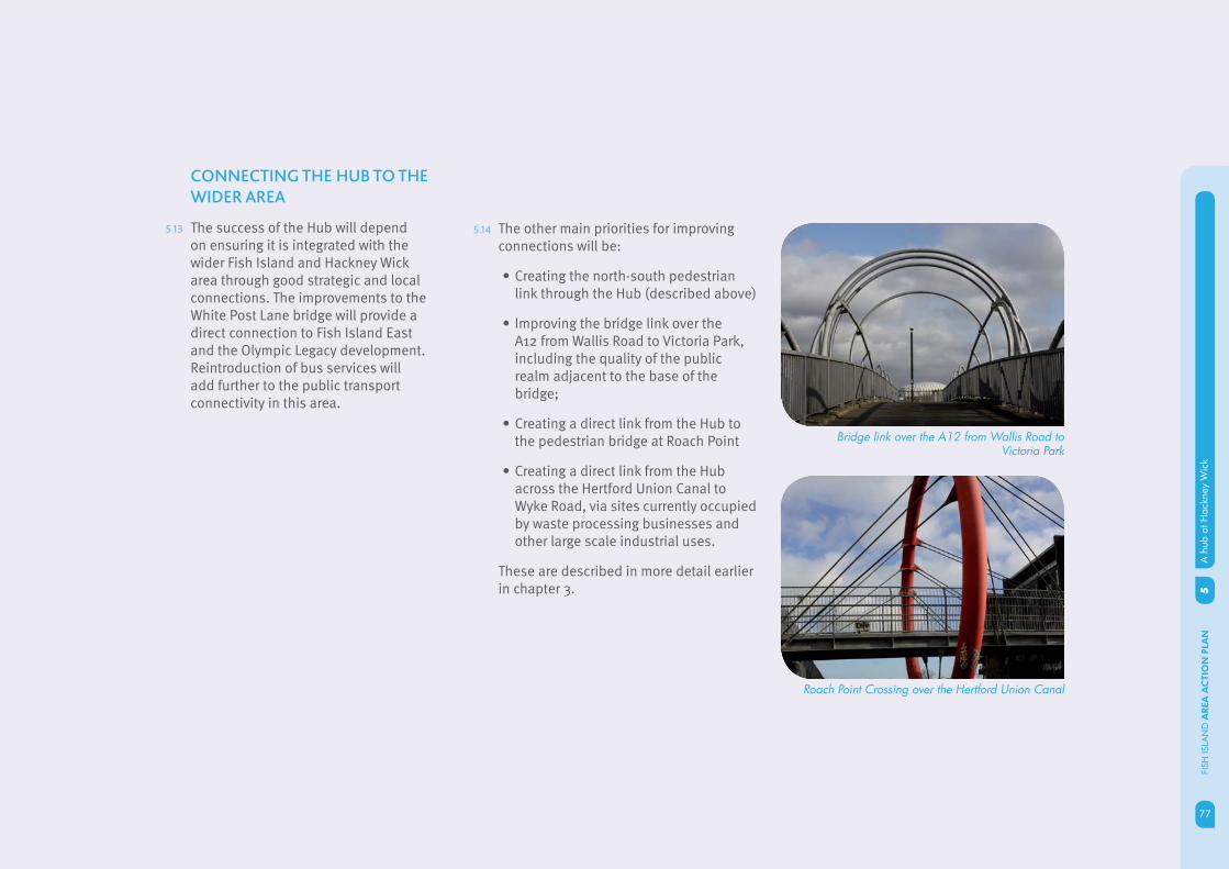
77
5A
hub
at H
ackn
ey W
ick
77
FISH
ISLA
ND
AREA
AC
TIO
N P
LAN
CONNECTING THE HUB TO THE
WIDER AREA
5.13 The success of the Hub will depend on ensuring it is integrated with the wider Fish Island and Hackney Wick area through good strategic and local connections. The improvements to the White Post Lane bridge will provide a direct connection to Fish Island East and the Olympic Legacy development. Reintroduction of bus services will add further to the public transport connectivity in this area.
5.14 The other main priorities for improving connections will be:
Creating the north-south pedestrian • link through the Hub (described above)
Improving the bridge link over the • A12 from Wallis Road to Victoria Park, including the quality of the public realm adjacent to the base of the bridge;
Creating a direct link from the Hub to • the pedestrian bridge at Roach Point
Creating a direct link from the Hub • across the Hertford Union Canal to Wyke Road, via sites currently occupied by waste processing businesses and other large scale industrial uses.
These are described in more detail earlier in chapter 3.
Bridge link over the A12 from Wallis Road to Victoria Park
Roach Point Crossing over the Hertford Union Canal

5A
hub
at H
ackn
ey W
ick
FISH
ISLA
ND
AREA
AC
TIO
N P
LAN
78
INTRODUCING RETAIL AND
OTHER TOWN CENTRE USES
5.15 Retail and employment activity will be focussed in the Hub area (defi ned above) to encourage as much activity as possible around the proposed public square and improved Station. Retail and employment uses in the Hub area will be located on the ground and lower fl oors of mixed-use developments, to ensure active street frontages. The Hub will also have an important role in supporting the cluster of small and micro businesses, particular in the creative sector that have established in Fish Island. A range of retail shop units and employment business spaces will be provided, including small shops and workspaces suitable for independent operators. This in turn will encourage more people to use the Station as a gateway to the area.
5.16 To create a vibrant neighbourhood centre that meets day to day needs of local communities, the mix of uses that will be encouraged will include:
Residential (above ground fl oor) (C3)
Workspace Studios (B1)
Galleries and exhibition space (D1)
Cafés, bars and restaurants (A3)
Convenience food shopping (A1)
Education (D1)
Community facilities (D1)
Creative industries workspace (i.e. artists, printing, fi lm, media) (B1)
Business innovation centre (B1)
This is to ensure an appropriate balance of uses in the Hub and non retail uses do not detract from or threaten the role and function of the Hub.
CREATING ACTIVE FRONTAGES
5.17 Active frontages are part of the character of important streets and ensures that the life of the building helps animate the street making it feel safer and more welcoming. Active frontages are particularly important on key routes as they not only provide opportunities for business activity and contribute to local character and identity, but also provide natural surveillance.
5.18 It is essential that an appropriate balance is achieved between busy streets and quieter streets, and that suffi cient active frontages are developed, particularly in the Hub. Building frontage should be substantially transparent so that the activity within the building is visible from the street, as well as including entries to buildings. This should also include opportunities for activity to spill out onto pavements through street cafes and shop displays. These active frontages should ideally relate to ground fl oor retail spaces, cafes, restaurants, public facilities, offi ce receptions, galleries and public facilities.
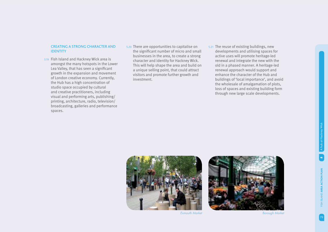
79
5A
hub
at H
ackn
ey W
ick
79
FISH
ISLA
ND
AREA
AC
TIO
N P
LAN
5.20 There are opportunities to capitalise on the signifi cant number of micro and small businesses in the area, to create a strong character and identity for Hackney Wick. This will help shape the area and build on a unique selling point, that could attract visitors and promote further growth and investment.
CREATING A STRONG CHARACTER AND
IDENTITY
5.19 Fish Island and Hackney Wick area is amongst the many hotspots in the Lower Lea Valley, that has seen a signifi cant growth in the expansion and movement of London creative economy. Currently, the Hub has a high concentration of studio space occupied by cultural and creative practitioners, including visual and performing arts, publishing/printing, architecture, radio, television/broadcasting, galleries and performance spaces.
Exmouth Market Borough Market
5.21 The reuse of existing buildings, new developments and utilising spaces for active uses will promote heritage-led renewal and integrate the new with the old in a phased manner. A heritage-led renewal approach would support and enhance the character of the Hub and buildings of ‘local importance’, and avoid the wholesale of amalgamation of plots, loss of spaces and existing building form through new large scale developments.
5A
hub
at H
ackn
ey W
ick
FISH
ISLA
ND
AREA
AC
TIO
N P
LAN
80
AAP POLICY FI 5.1
DEVELOPMENT MANAGEMENT
1. Development within Hackney Wick Hub should provide a mix of uses, and employment types for smaller businesses, which will be focussed around Hackney Wick Station, and a series of interconnected routes and spaces which form part of the Hub boundary.
2. New developments to ensure a coordinated approach to the delivery of the Hub either side of the railway line and borough boundary, and where appropriate, contribute to the improvements and upgrade of Hackney Wick Station .
3. New developments to provide a range of retail uses and unit sizes, in particular smaller units aimed at independent retail providers, to increase the retail offer and meet the future demands.
4. New developments should provide active ground fl oor frontages onto key routes, public spaces and fronting Hackney Wick Station. Careful consideration to the character of frontages, to ensure ground fl oor activity and animation is appropriate to the areas character.
5. Development at Hackney Wick should build on the unique character and of Hackney Wick and Fish Island by heritage-led renewal. Locally Listed Buildings and buildings of townscape merit within the Conservation Area, should be retained and reused where possible, and new developments should of a high quality and design, contributing to the architectural heritage of the area.
6. New developments to be well integrated into the Hub and its surroundings, enhancing routes to, from and within the Hub to the wider Fish Island, Hackney Wick area and to the future Queen Elizabeth Park.
IMPLEMENTATION
7. Work with partners to deliver comprehensive improvements and upgrade to Hackney Wick station linking surrounding developments, to create a public square and north/south route under the railway viaduct.
8. Detailed Development Brief for White Post Lane to facilitate the delivery of Hackney Wick Hub and associated station improvements and upgrade.
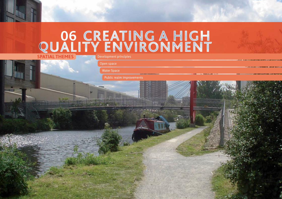
81
6C
reat
ing
a hi
gh q
ualit
y en
viro
nmen
t
81
FISH
ISLA
ND
AREA
AC
TIO
N P
LAN
Development principles
Open space
Water Space
Public realm improvements
06SPATIAL THEMES
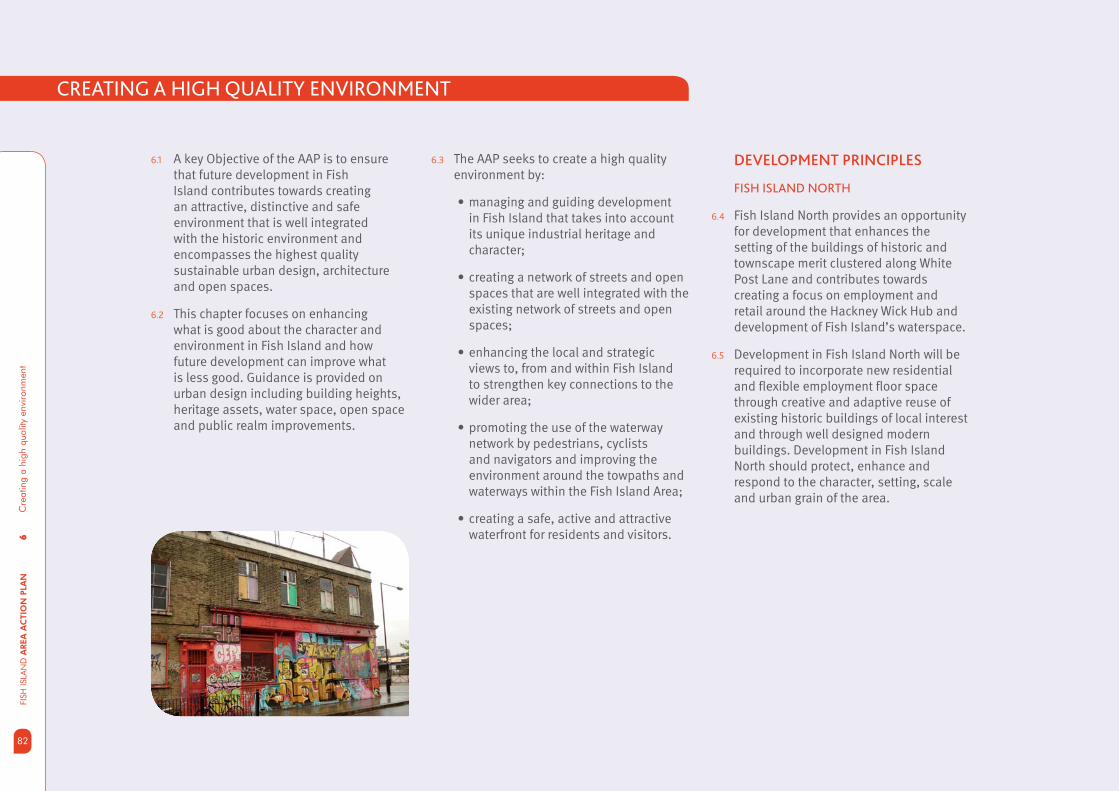
6C
reat
ing
a hi
gh q
ualit
y en
viro
nmen
tFI
SH IS
LAN
D A
REA
AC
TIO
N P
LAN
82
6.1 A key Objective of the AAP is to ensure that future development in Fish Island contributes towards creating an attractive, distinctive and safe environment that is well integrated with the historic environment and encompasses the highest quality sustainable urban design, architecture and open spaces.
6.2 This chapter focuses on enhancing what is good about the character and environment in Fish Island and how future development can improve what is less good. Guidance is provided on urban design including building heights, heritage assets, water space, open space and public realm improvements.
DEVELOPMENT PRINCIPLES
FISH ISLAND NORTH
6.4 Fish Island North provides an opportunity for development that enhances the setting of the buildings of historic and townscape merit clustered along White Post Lane and contributes towards creating a focus on employment and retail around the Hackney Wick Hub and development of Fish Island’s waterspace.
6.5 Development in Fish Island North will be required to incorporate new residential and fl exible employment fl oor space through creative and adaptive reuse of existing historic buildings of local interest and through well designed modern buildings. Development in Fish Island North should protect, enhance and respond to the character, setting, scale and urban grain of the area.
CREATING A HIGH QUALITY ENVIRONMENT
6.3 The AAP seeks to create a high quality environment by:
managing and guiding development • in Fish Island that takes into account its unique industrial heritage and character;
creating a network of streets and open • spaces that are well integrated with the existing network of streets and open spaces;
enhancing the local and strategic • views to, from and within Fish Island to strengthen key connections to the wider area;
promoting the use of the waterway • network by pedestrians, cyclists and navigators and improving the environment around the towpaths and waterways within the Fish Island Area;
creating a safe, active and attractive • waterfront for residents and visitors.

83
6C
reat
ing
a hi
gh q
ualit
y en
viro
nmen
t
83
FISH
ISLA
ND
AREA
AC
TIO
N P
LAN
6.6 A cluster of locally listed buildings and buildings of townscape merit north of the railway line are part of the Hackney Wick Conservation Area. South of the railway, buildings of local interest or townscape merit in Fish Island north are clustered around White Post Lane. These buildings, from various periods and exhibiting various styles, defi ne the industrial heritage of the area. There is an opportunity to designate a new Conservation Area that recognises the group value and townscape merit of these buildings.
6.7 The proposed conservation area is drawn tightly around the existing cluster of buildings of townscape merit and borders the canal edge to the east and to the south. The designation would enable special architectural and historic character of this area to be preserved or enhanced through new development, re-use and stewardship of the existing buildings. An indicative Conservation Area boundary is shown on fi g 6.1.
6.8 In addition to this, the buildings of townscape merit at the junction of Hepscott Road and White post Lane are proposed to be locally listed. Hackney Wick Hub would be at the heart of the neighbourhood centre where developments will be designed to complement the existing heritage assets within the area and Hackney Wick Conservation Area to the north of the railway line. The heritage assets designated in Hackney AAP shall also be carefully considered in the development of sites to create a balanced, heritage led redevelopment of the area.
6.9 The waterways are an important heritage asset and are integral to the area’s industrial character .Development will be promoted which enhances and stimulates activity along the canal front and increases access to the historic Hertford Union Canal and the Hackney Cut - Lea Navigation.
6.10 The proposed neighbourhood centre will generate activity and promote a number of new developments. Proposed building heights and massing needs to be carefully managed to facilitate developments that are considerate and respectful of the historic environment to the north (Hackney Wick Conservation Area), heritage assets in the area and the proposed locally listed buildings and Conservation Areas.
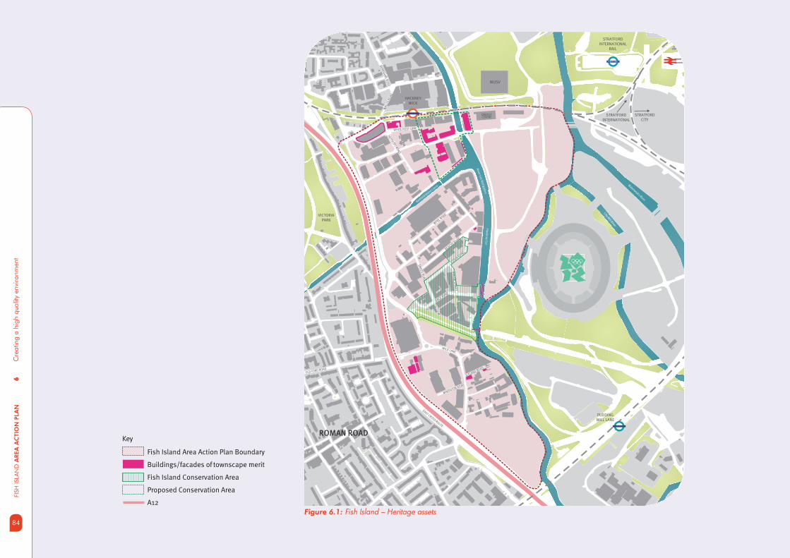
6C
reat
ing
a hi
gh q
ualit
y en
viro
nmen
tFI
SH IS
LAN
D A
REA
AC
TIO
N P
LAN
84
Figure 6.1: Fish Island – Heritage assets
Key
Fish Island Area Action Plan Boundary
Buildings/facades of townscape merit
Fish Island Conservation Area
Proposed Conservation Area
A12
Waterw
orks River
City Mill River
Ha
ckn
ey C
ut
Hertford
Unio
n Canal
Rive
r Lee
Na
viga
tion
STRATFORDINTERNATIONAL
RAIL
STRATFORD
VICTORIA PARK
EAST CROSS ROUTE
MUSV
ENERGYCENTRE
STRATFORDINTERNATIONAL
HACKNEY WICK
PUDDING MILL LANE
WA
LLIS
RO
AD
BER
KS
HIR
E R
OA
D
WICK LANE
MAVERTON ROAD
WHITE POST LANE
BEACHY ROAD
BR
EA
M S
TRE
ET
WYKE R
OAD
STOUR ROAD
DACE ROAD
SM
EE
D R
OA
D
HEPSC
OTT RO
AD
ICELAND ROAD
OLD FORD ROAD
STRATFORDCITY
ROMAN ROAD
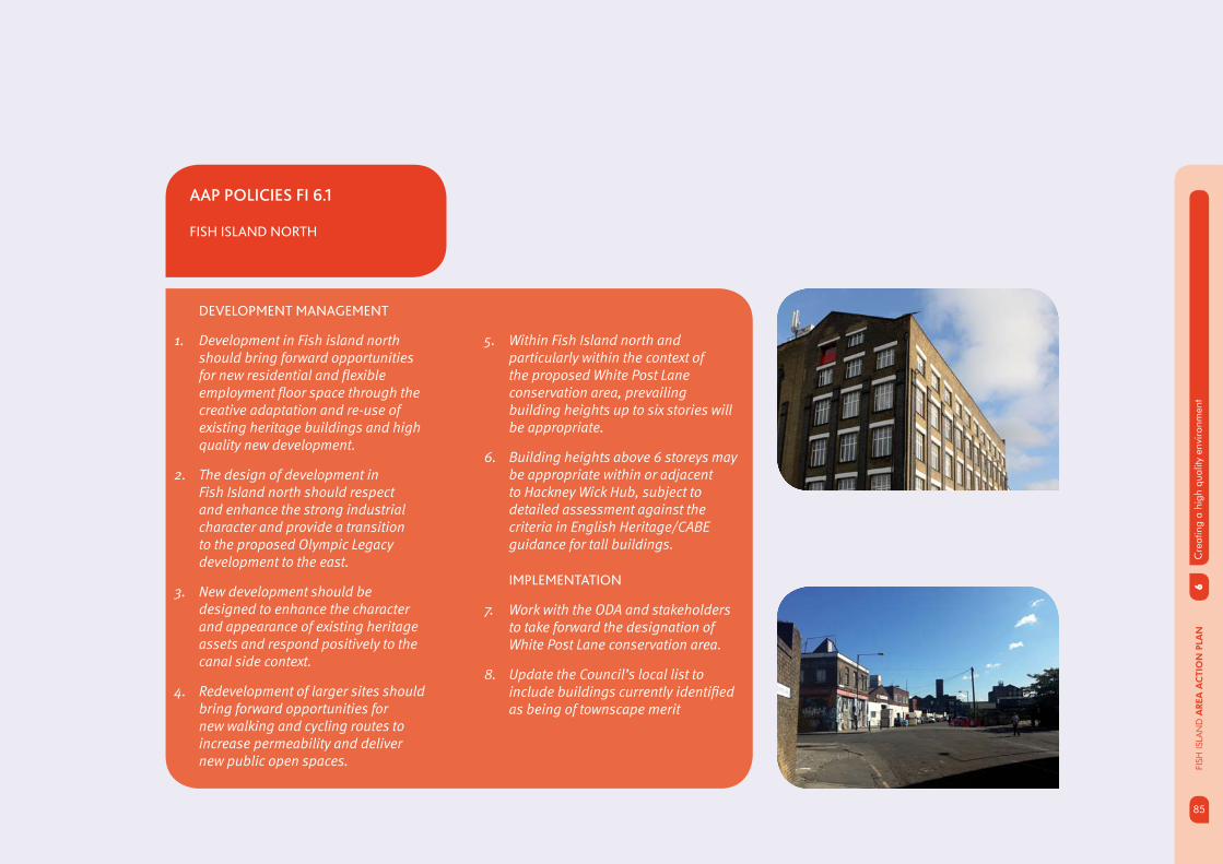
85
6C
reat
ing
a hi
gh q
ualit
y en
viro
nmen
t
85
FISH
ISLA
ND
AREA
AC
TIO
N P
LAN
AAP POLICIES FI 6.1
FISH ISLAND NORTH
DEVELOPMENT MANAGEMENT
1. Development in Fish island north should bring forward opportunities for new residential and fl exible employment fl oor space through the creative adaptation and re-use of existing heritage buildings and high quality new development.
2. The design of development in Fish Island north should respect and enhance the strong industrial character and provide a transition to the proposed Olympic Legacy development to the east.
3. New development should be designed to enhance the character and appearance of existing heritage assets and respond positively to the canal side context.
4. Redevelopment of larger sites should bring forward opportunities for new walking and cycling routes to increase permeability and deliver new public open spaces.
5. Within Fish Island north and particularly within the context of the proposed White Post Lane conservation area, prevailing building heights up to six stories will be appropriate.
6. Building heights above 6 storeys may be appropriate within or adjacent to Hackney Wick Hub, subject to detailed assessment against the criteria in English Heritage/CABE guidance for tall buildings.
IMPLEMENTATION
7. Work with the ODA and stakeholders to take forward the designation of White Post Lane conservation area.
8. Update the Council’s local list to include buildings currently identifi ed as being of townscape merit
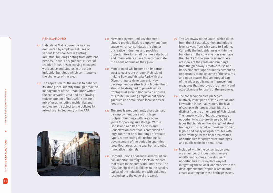
6C
reat
ing
a hi
gh q
ualit
y en
viro
nmen
tFI
SH IS
LAN
D A
REA
AC
TIO
N P
LAN
86
6.13 New employment-led development should provide fl exible employment fl oor space which consolidates the cluster of creative industries and provides opportunities for small business start-ups and intermediate space to accommodate the needs of fi rms as they grow.
6.14 Monier Road will become an important west to east route through Fish Island linking Bow and Victoria Park with the Olympic legacy development. New development on sites facing Monier Road should be designed to provide active frontages at ground fl oor which address this route, including employment space, galleries and small scale local shops or services.
6.15 The area is predominantly characterised by employment uses within large footprint buildings with large open yards for parking and storage. Within Fish Island Mid lies the Fish Island Conservation Area that is comprised of large footprint brick buildings of various types, representing the technological advancement of the period in spanning large fl oor areas using cast iron and other innovative materials.
6.16 Hertford Union Canal and Hackney Cut are two important heritage assets in the area that relate to the area’s industrial past. The relationship of the buildings to the canal is typical of the industrial era with buildings located up to the edge of the canal.
6.17 The Greenway to the south, which dates from the 1860s, takes high and middle level sewers from Wick Lane to Barking. Currently the industrial uses within the buildings in the conservation area have their backs to the greenway and there are views of the yards and buildings from the greenway. Creative reuse and Redevelopment opportunities present an opportunity to make some of these yards and open spaces into an integral part of the wider public realm improvement measures that improves the amenity and attractiveness for users of the greenway.
6.18 The conservation area preserves relatively intact parts of late Victorian and Edwardian industrial estates. The layout of streets with narrow urban blocks is distinct from the other parts of Fish Island. The narrow width of blocks presents an opportunity to explore diverse building types that builds on the strength of street frontages. The layout with well networked, legible and easily navigable routes with more frontage for the fl oor area creates opportunities for active street frontages and public realm in a small area.
6.19 Included within the conservation area are a number of industrial chimneys of different typology. Development opportunities must explore ways of integrating these local landmarks with the development and /or public realm and create a setting for these heritage assets.
FISH ISLAND MID
6.11 Fish Island Mid is currently an area dominated by employment uses of various kinds housed in existing industrial buildings dating from different periods. There is a signifi cant cluster of creative industries occupying managed work space and studios in the older industrial buildings which contribute to the character of the area.
6.12 The aspiration for the area is to enhance its strong local identity through proactive management of the urban fabric within the conservation area and by allowing redevelopment of industrial sites for a mix of uses including residential and employment, subject to the policies for mixed use, in Section 4 of the AAP.

87
6C
reat
ing
a hi
gh q
ualit
y en
viro
nmen
t
87
FISH
ISLA
ND
AREA
AC
TIO
N P
LAN
6.20 New developments present opportunities to create new links across the waterways and establish new connections and enhance existing links through and to Fish Island. The new connections are also opportunities for place making that recognises the local context and heritage assets in the immediate setting. Public realm improvements and considered design response to new links are fundamental in delivering the vision for the Fish Island AAP.
6.21 Wansbeck Road, which runs parallel to A12,is an important link within Fish Island which connects Fish Island with the wider area. Currently, due to the industrial uses along this stretch, Wansbeck road is characterised by dead frontages and poor quality public realm. Public realm improvement projects have been identifi ed along this stretch and some of these works will commence this year. The nature and quality of employment uses proposed as part of the AAP provides an opportunity for the development to create a presence on Wansbeck Road and create active frontages at ground level. Redevelopment of sites along Wansbeck Road also provides an opportunity to enhance the quality of public realm and improve the environment for pedestrians and cyclists.
AAP POLICIES FI 6.2
FISH ISLAND MID
DEVELOPMENT MANAGEMENT
1. Development in Fish Island mid should respect and enhance the unique street layout, urban form and fi ne grain character to provide opportunities to enhance the experience of the historic built environment.
2. Re-use and adaptation of historic factory and warehouse buildings, including sympathetic alterations or additions will be encouraged where it preserves and enhances the character and appearance of Fish Island conservation area, taking account of the Council’s published Conservation Area Character Appraisal and Management Guidelines.
3. Redevelopment of larger sites should bring forward opportunities for new walking and cycling routes and public open space to increase permeability and open up views to the waterways and across to the Olympic Park.
4. Within Fish island mid and particularly within the immediate setting of the conservation area, building heights of 4-6 storeys will be appropriate.
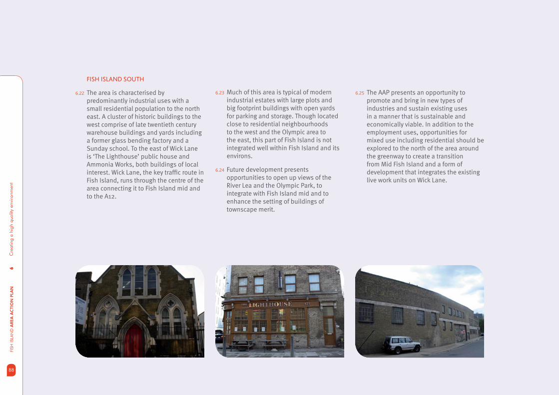
6C
reat
ing
a hi
gh q
ualit
y en
viro
nmen
tFI
SH IS
LAN
D A
REA
AC
TIO
N P
LAN
88
FISH ISLAND SOUTH
6.22 The area is characterised by predominantly industrial uses with a small residential population to the north east. A cluster of historic buildings to the west comprise of late twentieth century warehouse buildings and yards including a former glass bending factory and a Sunday school. To the east of Wick Lane is ‘The Lighthouse’ public house and Ammonia Works, both buildings of local interest. Wick Lane, the key traffi c route in Fish Island, runs through the centre of the area connecting it to Fish Island mid and to the A12.
6.23 Much of this area is typical of modern industrial estates with large plots and big footprint buildings with open yards for parking and storage. Though located close to residential neighbourhoods to the west and the Olympic area to the east, this part of Fish Island is not integrated well within Fish Island and its environs.
6.24 Future development presents opportunities to open up views of the River Lea and the Olympic Park, to integrate with Fish Island mid and to enhance the setting of buildings of townscape merit.
6.25 The AAP presents an opportunity to promote and bring in new types of industries and sustain existing uses in a manner that is sustainable and economically viable. In addition to the employment uses, opportunities for mixed use including residential should be explored to the north of the area around the greenway to create a transition from Mid Fish Island and a form of development that integrates the existing live work units on Wick Lane.

89
6C
reat
ing
a hi
gh q
ualit
y en
viro
nmen
t
89
FISH
ISLA
ND
AREA
AC
TIO
N P
LAN
AAP POLICIES FI 6.3
FISH ISLAND SOUTH
DEVELOPMENT MANAGEMENT
1. Comprehensive redevelopment of existing small scale industrial units will be supported where it delivers the key principles of intensifying industrial or employment fl oor space and provides employment fl oor space suitable for modern industry.
2. New development should be designed to provide active building frontages to Wick Lane to enhance natural surveillance and improve the quality of the built environment.
3. New development should incorporate opportunities to enhance the setting of existing buildings of townscape merit on Crown Close and Wick Lane.
4. Development should incorporate opportunities to increase views of the River Lea and across to the Olympic Park.
5. New development should be designed to rationalise and improve vehicular access arrangements.
6. Development either side of Wick Lane should be designed to respond positively to the existing live work units in terms of scale and location of the less intensive employment uses on the site.
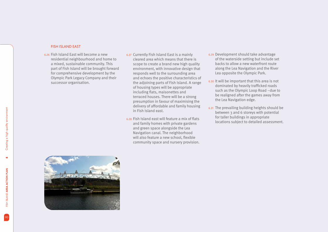
6C
reat
ing
a hi
gh q
ualit
y en
viro
nmen
tFI
SH IS
LAN
D A
REA
AC
TIO
N P
LAN
90
FISH ISLAND EAST
6.26 Fish Island East will become a new residential neighbourhood and home to a mixed, sustainable community. This part of Fish Island will be brought forward for comprehensive development by the Olympic Park Legacy Company and their successor organisation.
6.27 Currently Fish Island East is a mainly cleared area which means that there is scope to create a brand new high quality environment, with innovative design that responds well to the surrounding area and echoes the positive characteristics of the adjoining parts of Fish Island. A range of housing types will be appropriate including fl ats, maisonettes and terraced houses. There will be a strong presumption in favour of maximising the delivery of affordable and family housing in Fish Island east.
6.28 Fish Island east will feature a mix of fl ats and family homes with private gardens and green space alongside the Lea Navigation canal. The neighborhood will also feature a new school, fl exible community space and nursery provision.
6.29 Development should take advantage of the waterside setting but include set backs to allow a new waterfront route along the Lea Navigation and the River Lea opposite the Olympic Park.
6.30 It will be important that this area is not dominated by heavily traffi cked roads such as the Olympic Loop Road –due to be realigned after the games away from the Lea Navigation edge.
6.31 The prevailing building heights should be between 3 and 6 storeys with potential for taller buildings in appropriate locations subject to detailed assessment.
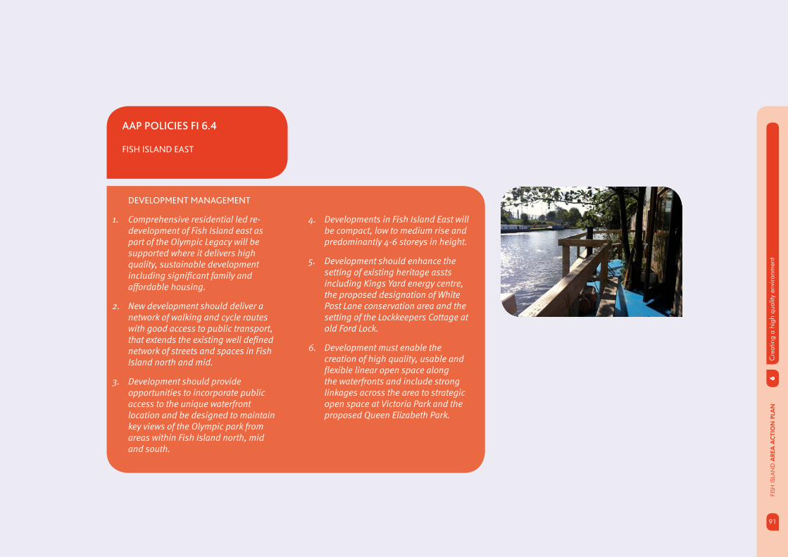
91
6C
reat
ing
a hi
gh q
ualit
y en
viro
nmen
t
91
FISH
ISLA
ND
AREA
AC
TIO
N P
LAN
AAP POLICIES FI 6.4
FISH ISLAND EAST
DEVELOPMENT MANAGEMENT
1. Comprehensive residential led re-development of Fish Island east as part of the Olympic Legacy will be supported where it delivers high quality, sustainable development including signifi cant family and affordable housing.
2. New development should deliver a network of walking and cycle routes with good access to public transport, that extends the existing well defi ned network of streets and spaces in Fish Island north and mid.
3. Development should provide opportunities to incorporate public access to the unique waterfront location and be designed to maintain key views of the Olympic park from areas within Fish Island north, mid and south.
4. Developments in Fish Island East will be compact, low to medium rise and predominantly 4-6 storeys in height.
5. Development should enhance the setting of existing heritage assts including Kings Yard energy centre, the proposed designation of White Post Lane conservation area and the setting of the Lockkeepers Cottage at old Ford Lock.
6. Development must enable the creation of high quality, usable and fl exible linear open space along the waterfronts and include strong linkages across the area to strategic open space at Victoria Park and the proposed Queen Elizabeth Park.

6C
reat
ing
a hi
gh q
ualit
y en
viro
nmen
tFI
SH IS
LAN
D A
REA
AC
TIO
N P
LAN
92
OPEN SPACE
6.32 Fish Island is well placed to take advantage of major open spaces at Victoria Park and those emerging within the Olympic Park. Establishing good connections between the new residential communities in north, mid and eastern parts of Fish Island and these open spaces will be essential to allow the level of growth expected over the next 15 years.
6.33 In addition, new residents and families will need to have easy access to more local open spaces close to where they live, so that a choice of different types of open space catering for activities ranging from informal play through to sporting activities are available.
6.34 To achieve this, the AAP will need to identify opportunities for a network of local open spaces to come forward as sites are re-developed. The main opportunities for new public open space will be:
public square or piazza as part of the • Hub at Hackney Wick to provide a focus for activity and improved links to Hackney Wick Station;
new green space (up to 1 ha) as part of • the comprehensive redevelopment of larger sites north of the Hertford Union Canal;
new green space (up to 1 ha) a part of • the comprehensive redevelopment of larger sites south of the Hertford Union canal;
a new informal open space in the • vicinity of the historic chimney at the junction of Stour Road and Beachy Road;
a new local or open square with • connections to and from the Greenway in Fish Island south adjacent to 417 Wick Lane.
6.35 In addition, the comprehensive redevelopment of Fish Island east presents the opportunity to provide new linear open spaces alongside the Lea Navigation and River Lea. Additional green space should be provided alongside the proposed school in a central, accessible location along the proposed extension of Monier Road through the development.
6.36 Fig 6.2 demonstrates how the provision of the local open spaces and the larger strategic opens paces could be linked in a network through the Greenway, a park to park route from Victoria Park to Queen Elizabeth II Park and via improvements to the network of streets in Fish Island. This will assist in implementing Tower Hamlets Green Grid across Fish Island and into the Olympic Legacy Area.
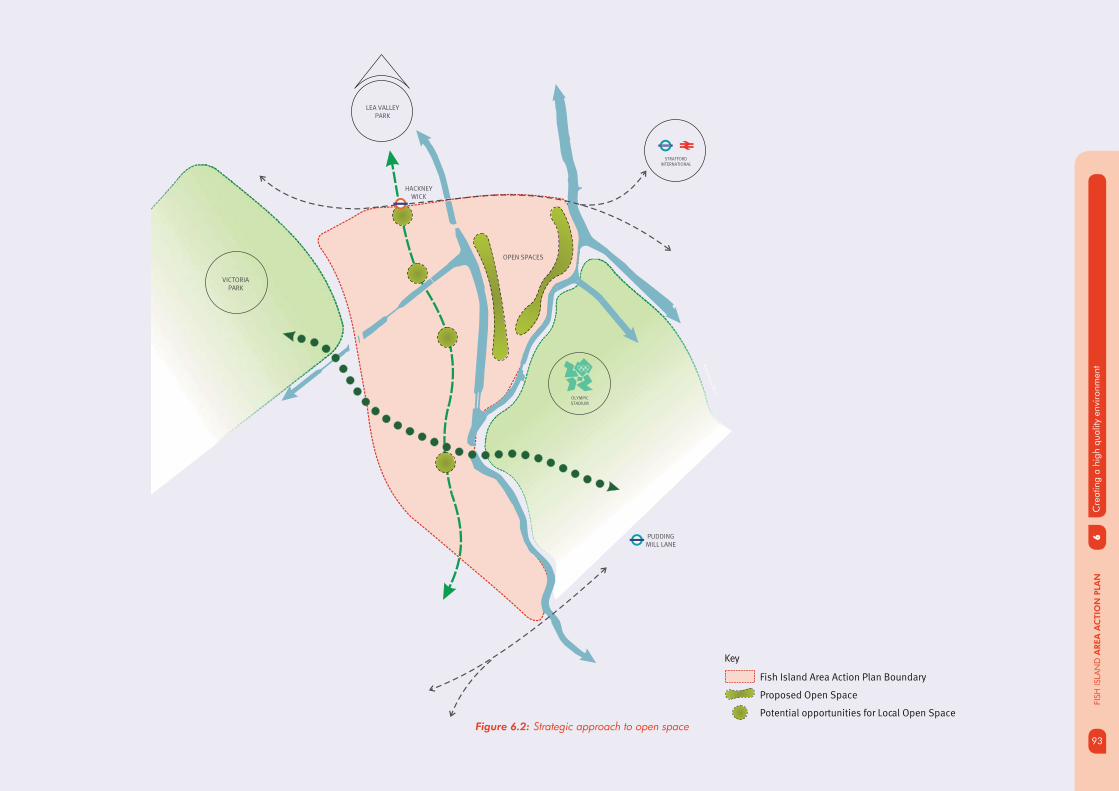
93
6C
reat
ing
a hi
gh q
ualit
y en
viro
nmen
t
93
FISH
ISLA
ND
AREA
AC
TIO
N P
LAN
Figure 6.2: Strategic approach to open space
Key
Fish Island Area Action Plan Boundary
Proposed Open Space
Potential opportunities for Local Open Space
Wa
terw
orks R
iver
Bow Back River
STRATFORDINTERNATIONAL
HACKNEY WICK
PUDDING MILL LANE
LEA VALLEYPARK
OPEN SPACES
OLYMPICSTADIUM
VICTORIA PARK
STRATFORD

6C
reat
ing
a hi
gh q
ualit
y en
viro
nmen
tFI
SH IS
LAN
D A
REA
AC
TIO
N P
LAN
94
WATER SPACE
6.37 Fish Island enjoys extensive stretches of water frontage along the Lea Navigation, Hertford Union Canal and River Lea. Redevelopment along the waterfront has the potential to make this area one of the most enjoyable segments of the waterways within Tower Hamlets. This will provide an opportunity to enhance connections between places, both visually and physically, and reinvigorate waterspaces by supporting development of active frontages along the waterways.
6.38 Currently the waterfront preserves an industrial character as a legacy of Fish Island’s industrial heritage. The industrial frontages include old and new buildings many of which are in industrial use alongside some modern live work developments. The industrial character of the waterfront is well preserved in comparison to other stretches of London’s waterway and lends the area a distinctive attractiveness.
The waterways are an important source of recreation and sport for locals and visitors alike and Fish Island’s waterspace has the potential to become a visitor destination in its own right and attract investment, businesses and new residents. The waterways also play an important role for houseboats and navigation of other waterborne traffi c. In the context of the redevelopment opportunities and aspirations for the area, the waterfront can be broadly defi ned in three distinct character zones defi ned by uses, building types and relationship to waterfront (fi g 6.2).
1. Residential zone - This zone includes the Lea Navigation canal frontage and Hertford Union Canal frontage in Fish Island North and Fish Island Mid.
2. Industrial zone – this zone includes the Lea Navigation canal frontage in Fish Island South
3. Green space zone – this is the zone along the Lea Navigation between Fish Island East and the Olympic Park.
6.39 The waterways which divide Fish Island have contributed to the uniqueness of its constituent parts. The waterways must be managed to provide an attractive setting for movement between the different areas along tow paths and also provide appropriate and suffi cient crossings so that the waterways become connectors and not dividers.
6.40 The canal will be enlivened with active frontages and access points that stimulate busy thoroughfares which add to the area’s natural surveillance and the perceived safety of the area. Connectivity options should therefore encourage people to use the towpaths where possible rather than to simply pass over the waterways. The proposed pedestrian crossing over the Hertford Union lock provides an example of actively encouraging interaction with the canals.

95
6C
reat
ing
a hi
gh q
ualit
y en
viro
nmen
t
95
FISH
ISLA
ND
AREA
AC
TIO
N P
LAN
6.41 In the residential and green space zone dynamic uses of the waterways will be supported to enhance the character and activity of the areas. Cities which have undergone waterspace regeneration in the past have encouraged enhanced mooring facilities, fl oating commercial vessels such as cafes and restaurants, ‘park and glide’ schemes, angling, punting and kayaking centres. Introduction of canal side lighting will be considered if it enhances the safety of pedestrian and cycle traffi c. Amsterdam, Venice and Copenhagen provide examples of dynamic utilitarian approaches to waterside development. Development proposals will be considered in light of their complementarity to the British Waterways Lower Lea Valley Waterspace Strategy.
6.42 The water network is currently navigated by residential and commercial vessels and a number of residential boats use the area for mooring. The requirements of boaters must be integral to development on the waterways. The permanent and temporary mooring of boats provides regenerative benefi ts and the accommodation of mooring facilities will be supported where appropriate, as will water based attractions or diverse water uses such as ‘working afl oat’.
6.43 Development in Fish Island South will need to be sensitive to the water frontage and not harm the visual attractiveness of the area. Canal side development should consider strategic location in terms of proximity to the waterways for logistical and industrial operations, including loading and unloading of freight. Finding new uses for historic buildings is encouraged and should follow the principles of minimum intervention.
6.44 Heritage Assessments and Character Appraisals must be carried out at the initial stages of a project to consider the signifi cance of waterway surroundings. Townscape and waterspace assessment must be carried out in conjunction with other appraisals to fully assess the impact of development. Further design guidance informed by the character assessments and the emerging Lower Lea Valley Waterspace Strategy will be developed for each of the character zones in the next stage of the AAP.

6C
reat
ing
a hi
gh q
ualit
y en
viro
nmen
tFI
SH IS
LAN
D A
REA
AC
TIO
N P
LAN
96
AAP POLICIES FI 6.5
WATER SPACE
DEVELOPMENT MANAGEMENT
New development should adhere to design principles appropriate to the waterside setting and encourage activity and interaction by:
• providing views from within the built up area to the waterways. Enhancing the main public views along the waterways including the long distance view along the Hertford Union Canal towards the City of London;
• providing buildings of an appropriate scale to defi ne the edges of the waterways;
• introducing active frontages adjacent to the water’s edge including small scale cafés, bars, galleries, workshops and visually active areas within industrial developments;
• providing new or contributing to improvements to existing canal-side access points;
• contributing towards public realm improvements and waterspace infrastructure that benefi t the waterways directly or enhance access to the waterways;
• protecting the ecological values of the waterspace and ensuring any negative environmental impacts are minimised and mitigated;
• safeguarding space to enhance existing tow path connections;
• maintaining an open and inviting public realm, avoiding walls, fences or other divides between the public realm and the waterfront;
• making use of the waterways for industrial uses including transportation of freight.
IMPLEMENTATION
Working with partners on the delivery of the Lower Lea Valley Waterspace Strategy and the Blue Grid Network
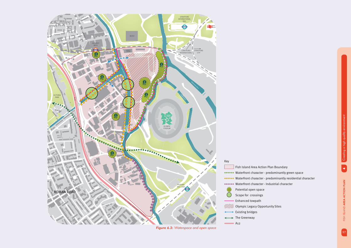
97
6C
reat
ing
a hi
gh q
ualit
y en
viro
nmen
t
97
FISH
ISLA
ND
AREA
AC
TIO
N P
LAN
Waterw
orks River
City Mill River
Ha
ckn
ey C
ut
Hertford
Unio
n Canal
River Lee N
aviga
tion
STRATFORDINTERNATIONAL
RAIL
A 12
BLACKWALL TUNNEL NORTHERN APPROACH
A 1
2
OLYMPICSTADIUM
VICTORIA PARK
EAST CROSS ROUTE
MUSV
ENERGYCENTRE
STRATFORDINTERNATIONAL
HACKNEY WICK
PUDDING MILL LANE
WA
LLIS
RO
AD
BER
KS
HIR
E RO
AD
WICK LANE
MAVERTON ROAD
WHITE POST LANE
BEACHY ROAD
BR
EA
M S
TRE
ET
WYKE R
OAD
STOUR ROAD
DACE ROAD
SM
EE
D R
OA
D
HEPSC
OTT RO
AD
ICELAND ROAD
OLD FORD ROAD
STRATFORDCITY
ROMAN ROAD
STRATFORD
Figure 6.3: Waterspace and open space
Key
Fish Island Area Action Plan Boundary
Waterfront character - predominantly green space
Waterfront character - predominantly residential character
Waterfront character - Industrial character
Potential open space
Scope for crossings
Enhanced towpath
Olympic Legacy Opportunity Sites
Existing bridges
The Greenway
A12

6C
reat
ing
a hi
gh q
ualit
y en
viro
nmen
tFI
SH IS
LAN
D A
REA
AC
TIO
N P
LAN
98
PUBLIC REALM IMPROVEMENTS
6.45 To support the delivery of effective and high quality new and improved walking, cycling and vehicle routes, there is a need to improve the public realm and local environment to create better connections to and from Fish Island. Public realm interventions will need to enhance existing and proposed routes, and where appropriate deliver public amenity space that act as a focus of activity and navigates pedestrian and cyclist through the area. The canals and the Greenway form part of the area’s network of walking and cycling green routes, which link Fish Island to the Olympic Park. There is potential to create a programme of new or improved green spaces or active uses along key walking and cycling routes, which will link into the wider open space network. This fi ts into the wider Green Grid Strategy in the borough to improve the walking and cycling links between open spaces.
6.46 As the area begins to transform from its historic industrial nature to mixed use, the hierarchy of the street network will change, as new streets and routes are delivered to improve connectivity and accessibility within the area. Public realm improvements to routes and areas, that form key strategic walking and cycling links into the Olympic Park through Fish Island, will reinforce local connections and increase permeability. The delivery of interconnected high quality routes and spaces will signifi cantly improve the local environment for future residents, workers and visitors alike.
6.47 The Council has been working with partner agencies to identify public realm ‘strategic interventions’ to improve key routes and areas within or adjacent to Fish Island, in response to the priorities for Fish Island, 2012 Olympic and Para-Olympic games, and legacy facilities. These key routes play a signifi cant role at a strategic and local level, to ensure the community are able to access the facilities and opportunities in Fish Island and the surrounding neighbourhood.
6.48 The area has been subject to a number of public realm interventions to key routes which are funded by different agencies (Olympic Park Legacy Company, London Thames Gateway Development Corporation and Olympic Delivery Authority) and coordinated to deliver a strategic network of improvements across the area. These improvements are in response to the signifi cant investment required to improve the pedestrian and cyclist environment pre Olympics.
6.49 The regeneration of Fish Island will undergo continuous transition, as it develops from industrial employment to other uses such residential and retail. Further investment in the local environment and public realm are required to maximise the quality of the environment, and support the future needs of existing and future communities. Several key priority walking and cycling routes have been identifi ed to ensure future public realm provision further enhances accessibility and legibility within the area. Public realm interventions on these key priority routes, bring together a programme of environmental improvements to existing and proposed routes. These routes shown on fi g 6.4.
99
6C
reat
ing
a hi
gh q
ualit
y en
viro
nmen
t
99
FISH
ISLA
ND
AREA
AC
TIO
N P
LAN
AAP POLICIES FI 6.6
PUBLIC REALM
DEVELOPMENT MANAGEMENT
The council will expect new development to adhere to the following public realm principles and where appropriate, contribute to their delivery:
• Enhance the open space network by providing greener routes and the introduction of new spaces that navigate people through the area in line with the Green Grid Strategy.
• Contribute to high quality public realm improvements which link into the wider movement pattern in the area and ensures a legible, attractive and safe environment for pedestrians and cyclists.
• Public realm improvements to promote a strong sense of place, a distinct and positive identity which respects the historic environment and character of the area.
• New developments to reconfi gure connections to respond to pedestrian desire lines and/ or establish future desire lines, by creating a seamless public realm which co-ordinates existing and new development.
IMPLEMENTATION
Priorities for public realm improvements to support the overall vision for Fish Island will be:
• Wansbeck Road corridor to improve the overall environmental quality and experience for cyclists and pedestrians;
• Crown Close and Wick Lane to enhance the quality and experience of the key connection across the A12, to mitigate the impact of traffi c related to industrial uses on Wick Lane and to improve pedestrian and cycle links across the A12;
• White Post Lane and Rothbury Road to improve the setting of locally listed buildings and those within the proposed conservation area;
• Dace Road and Old Ford Lock to improve the setting of Fish Island Conservation Area buildings and the setting of the historic locks;
• Monier Road to enhance the future role of this connection to Fish Island East and to complement proposed junction alterations at Monier Road and Wansbeck Road.
• Wallis Road to strengthen the key route from Victoria Park and future Queen Elizabeth Park to deliver a new park to park east-west route by enhancing the pedestrian and cycle environment.
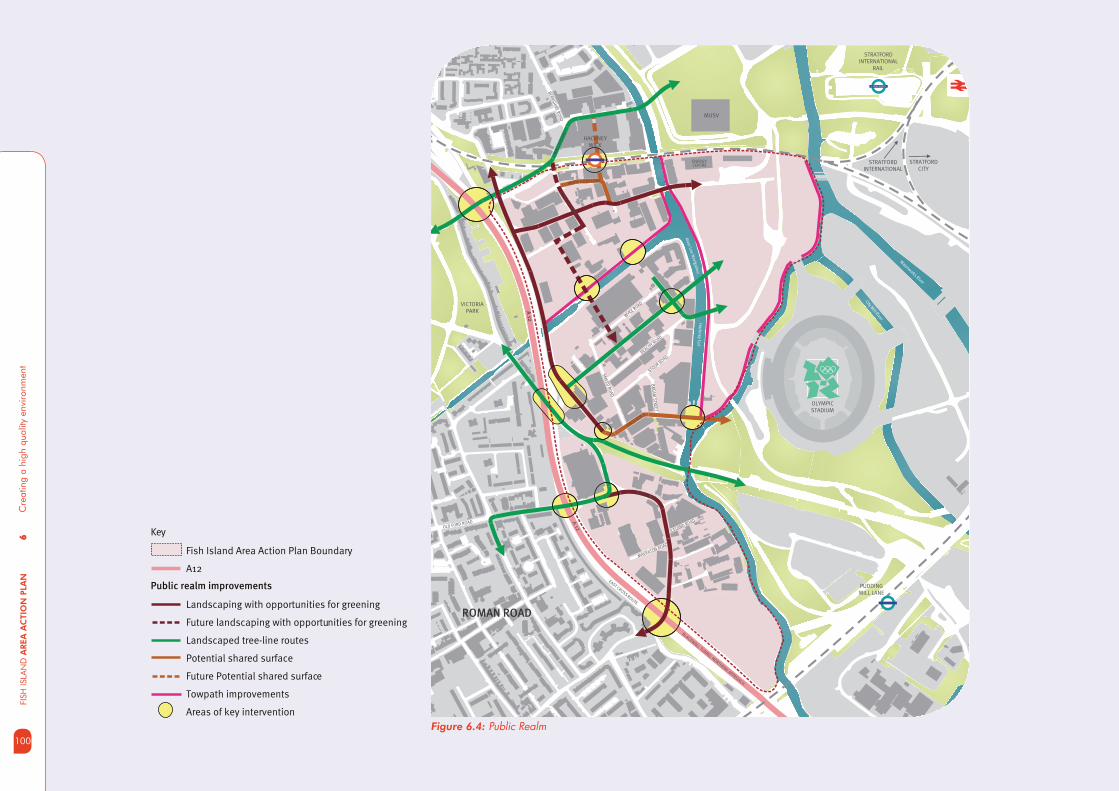
6C
reat
ing
a hi
gh q
ualit
y en
viro
nmen
tFI
SH IS
LAN
D A
REA
AC
TIO
N P
LAN
100
Figure 6.4: Public Realm
Key
Fish Island Area Action Plan Boundary
A12
Landscaping with opportunities for greening
Future landscaping with opportunities for greening
Landscaped tree-line routes
Potential shared surface
Future Potential shared surface
Towpath improvements
Areas of key intervention
Public realm improvements
Waterw
orks River
City Mill River
Ha
ckn
ey C
ut
Rive
r Lee
Na
viga
tion
STRATFORDINTERNATIONAL
RAIL
A 12
BLACKWALL TUNNEL NORTHERN APPROACH
A 1
2
OLYMPICSTADIUM
VICTORIA PARK
EAST CROSS ROUTE
MUSV
ENERGYCENTRE
STRATFORDINTERNATIONAL
HACKNEY WICK
PUDDING MILL LANE
WA
LLIS
RO
AD
BER
KS
HIR
E RO
AD
WICK LANE
MAVERTON ROAD
WHITE POST LANE
BEACHY ROAD
BR
EA
M S
TRE
ET
WYKE R
OAD
STOUR ROAD
DACE ROAD
SM
EE
D R
OA
D
HEPSC
OTT RO
AD
ICELAND ROAD
OLD FORD ROAD
STRATFORDCITY
ROMAN ROAD
STRATFORD

101
7D
eliv
erin
g su
stai
nabl
e re
gene
ratio
n
101
FISH
ISLA
ND
AREA
AC
TIO
N P
LAN
Climate Change and energy effi ciency
Managing Flood Risk
Delivering the AAP
Opportunity sites
Funding and delivering infrastructure
Monitoring
Next steps
07

7D
eliv
erin
g su
stai
nabl
e re
gene
ratio
nFI
SH IS
LAN
D A
REA
AC
TIO
N P
LAN
102
7.1 Development in Fish Island is expected to deliver a signifi cant number of new jobs and homes over the next 15 -20 years. This presents an opportunity to provide a place which promotes sustainable lifestyles through well designed buildings and spaces, and that help to enhance local biodiversity, use energy effi ciently, mange the impact of waste, mitigate the impact of climate change and promote walking, cycling and the use of public transport.
ACHIEVING SUSTAINABLE DEVELOPMENT
7.2 The Core Strategy seeks to achieve wider economic and environmental sustainability simultaneously and recognises the important interrelated health benefi ts of well designed neighbourhoods, high quality housing, access to employment opportunities, access to open space and access to shops and services.
7.3 The preceding sections of the AAP set out how these principles can apply to the future vision of development in Fish Island. This section sets out some of the key considerations for achieving environmental sustainability in future development.
7.4 The Area Action Plan will seek to achieve sustainable development by:
• Minimising carbon emission through the use of energy effi cient and renewable technologies
• Exploring the opportunities to create a low carbon area.
• Promote an integrated and sustainable approach to the management of development and fl ood risk to ensure sustainable growth and development into the future.
• Ensure new developments adopt sustainable design and construction measures.
• To plan for future change and demand, new developments should be adaptable and fl exible of use during their lifetime.
103
7D
eliv
erin
g su
stai
nabl
e re
gene
ratio
n
103
FISH
ISLA
ND
AREA
AC
TIO
N P
LAN
CLIMATE CHANGE AND
ENERGY EFFICIENCY
7.5 The London plan seeks to achieve an overall reduction in London’s carbon dioxide emissions (CO2) of 60% by 2025 (based on 1990 levels). The Mayor of London expects boroughs to contribute to meeting this target through their plan making and development management responsibilities.
7.6 Tower Hamlets Core Strategy seeks to achieve a zero carbon borough by 2025 and sets out a strategic approach to achieving this through the designation of low carbon areas in which new development should achieve higher levels of carbon reductions than elsewhere in the borough. These areas are based in the concentration of future development sites. Fish Island is included as a low carbon area.
7.7 The Olympic Energy Centre at Kings Yard in Fish Island East provides the opportunity for new developments in the area to connect to a new decentralised energy network which is interlinked into the wider energy network. A local heat and power network would make it affordable for new developments to make greater carbon savings.
7.8 The Council will work with its partners, land owners and developers to develop an area wide energy strategy and explore opportunities to interconnect and link into wider energy networks to improve energy and low carbon effi ciency in Fish Island.
7.9 Adaptation to the effects of climate change will be as important as minimising the contribution that new development and infrastructure makes towards those effects. Given this, new developments will need to demonstrate exemplary water effi ciency measures and landscape planting that will thrive at increased temperatures (and lower precipitation levels) whilst providing shade, enhancements to biodiversity and aesthetic value. Where possible, onsite renewable energy generation for both residential and industrial development will also increase the level of self suffi ciency across Fish Island.
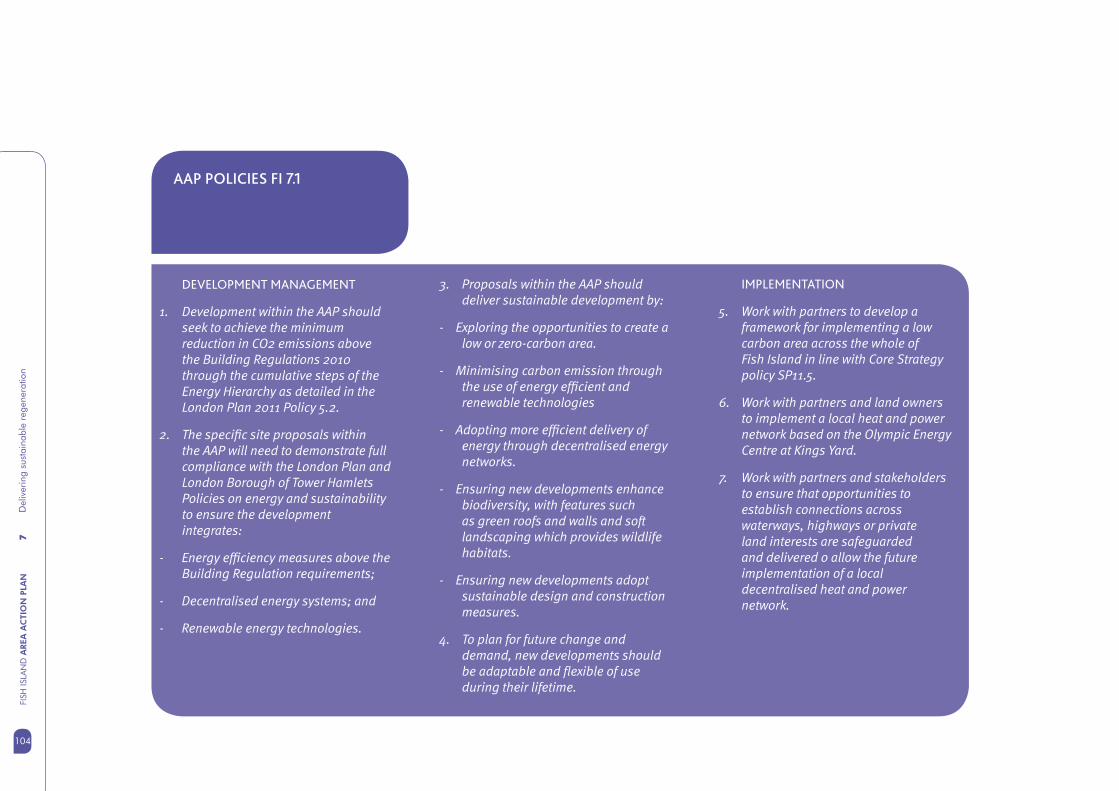
7D
eliv
erin
g su
stai
nabl
e re
gene
ratio
nFI
SH IS
LAN
D A
REA
AC
TIO
N P
LAN
104
AAP POLICIES FI 7.1
DEVELOPMENT MANAGEMENT
1. Development within the AAP should seek to achieve the minimum reduction in CO2 emissions above the Building Regulations 2010 through the cumulative steps of the Energy Hierarchy as detailed in the London Plan 2011 Policy 5.2.
2. The specifi c site proposals within the AAP will need to demonstrate full compliance with the London Plan and London Borough of Tower Hamlets Policies on energy and sustainability to ensure the development integrates:
- Energy effi ciency measures above the Building Regulation requirements;
- Decentralised energy systems; and
- Renewable energy technologies.
3. Proposals within the AAP should deliver sustainable development by:
- Exploring the opportunities to create a low or zero-carbon area.
- Minimising carbon emission through the use of energy effi cient and renewable technologies
- Adopting more effi cient delivery of energy through decentralised energy networks.
- Ensuring new developments enhance biodiversity, with features such as green roofs and walls and soft landscaping which provides wildlife habitats.
- Ensuring new developments adopt sustainable design and construction measures.
4. To plan for future change and demand, new developments should be adaptable and fl exible of use during their lifetime.
IMPLEMENTATION
5. Work with partners to develop a framework for implementing a low carbon area across the whole of Fish Island in line with Core Strategy policy SP11.5.
6. Work with partners and land owners to implement a local heat and power network based on the Olympic Energy Centre at Kings Yard.
7. Work with partners and stakeholders to ensure that opportunities to establish connections across waterways, highways or private land interests are safeguarded and delivered o allow the future implementation of a local decentralised heat and power network.

105
7D
eliv
erin
g su
stai
nabl
e re
gene
ratio
n
105
FISH
ISLA
ND
AREA
AC
TIO
N P
LAN
7.11 In accordance with Table D2 of PPS 25, the classifi cations of the proposed land uses that will come forward through the AAP are as follows:
7.12 The current site frontage with the River Lee Navigation in Fish Island East predominantly consists of concrete and sheet pile hard edge. The Thames River Basin Management Plan has identifi ed mitigation measures for the watercourse to help achieve a ‘good’ ecological status. Development provides the opportunity to enhance the river frontage encouraging both habitat creation and public access to the water whilst also acting to prevent erosion and provide fl ood protection to the area.
Proposed Land Use Vulnerability Classifi cation
Housing development More vulnerable
Commercial development including offi ces, industrial development, shops, cafes, restaurants, leisure and community uses
Less vulnerable
Primary / Secondary Schools More vulnerable
Open Space Water-compatible development
Health facility More vulnerable
Waste management / District heating facility Essential infrastructure
MANAGING FLOOD RISK
7.10 The Fish Island AAP lies within a combination of Flood Zones 1, 2 and 3. (see Fig 7.x). This means that certain parts of Fish Island have either a low, medium or high probability of fl ooding based on the Environment Agency defi nition of fl ood risk. In responding to and managing the impact of fl ood risk, there is the opportunity to adopt the sequential approach to development layout by locating more vulnerable and essential infrastructure within the Flood Zone 1 and 2 areas on site and ‘water compatible’ uses located within Flood Zone 3 and closer to the watercourses. The location of more vulnerable and essential infrastructure uses within Flood Zone 3 will require the Exception Test as set out PPS25. (Development and Flood Risk)
7.13 The Council has carried out a borough wide Strategic Flood Risk Assessment and a more detailed site assessment to inform how development in Fish Island should respond to Flood Risk.
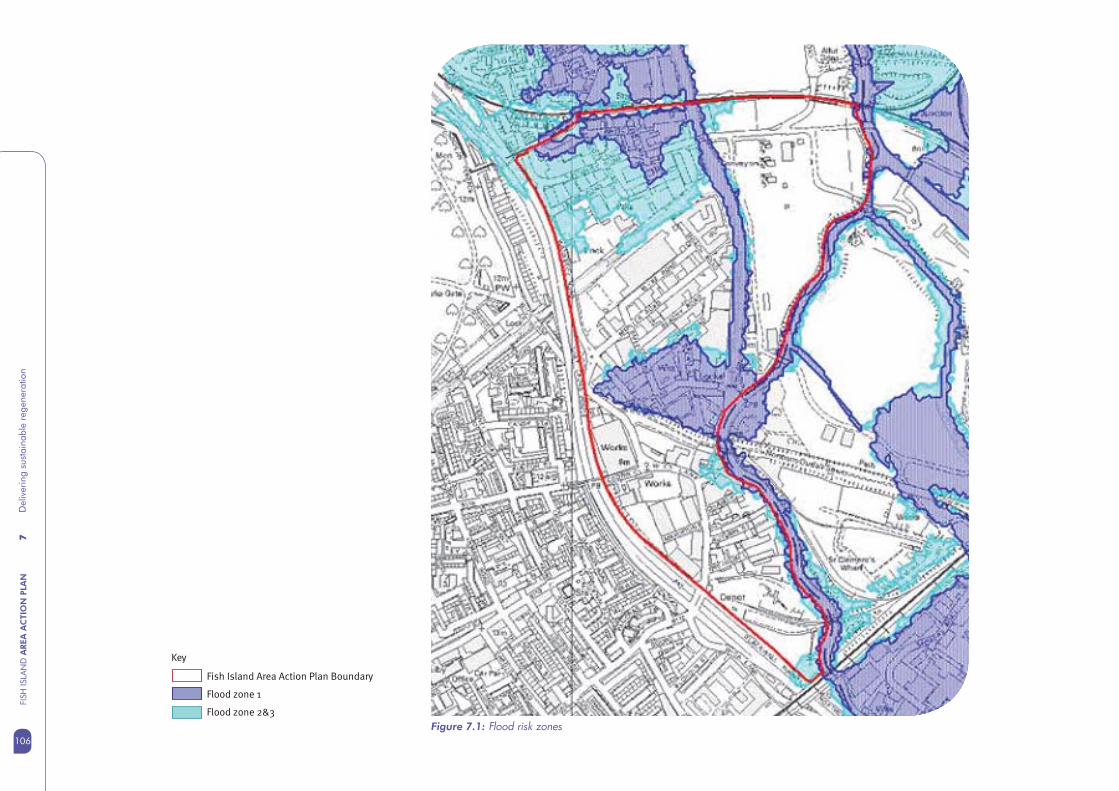
7D
eliv
erin
g su
stai
nabl
e re
gene
ratio
nFI
SH IS
LAN
D A
REA
AC
TIO
N P
LAN
106
Figure 7.1: Flood risk zones
Key
Fish Island Area Action Plan Boundary
Flood zone 1
Flood zone 2&3
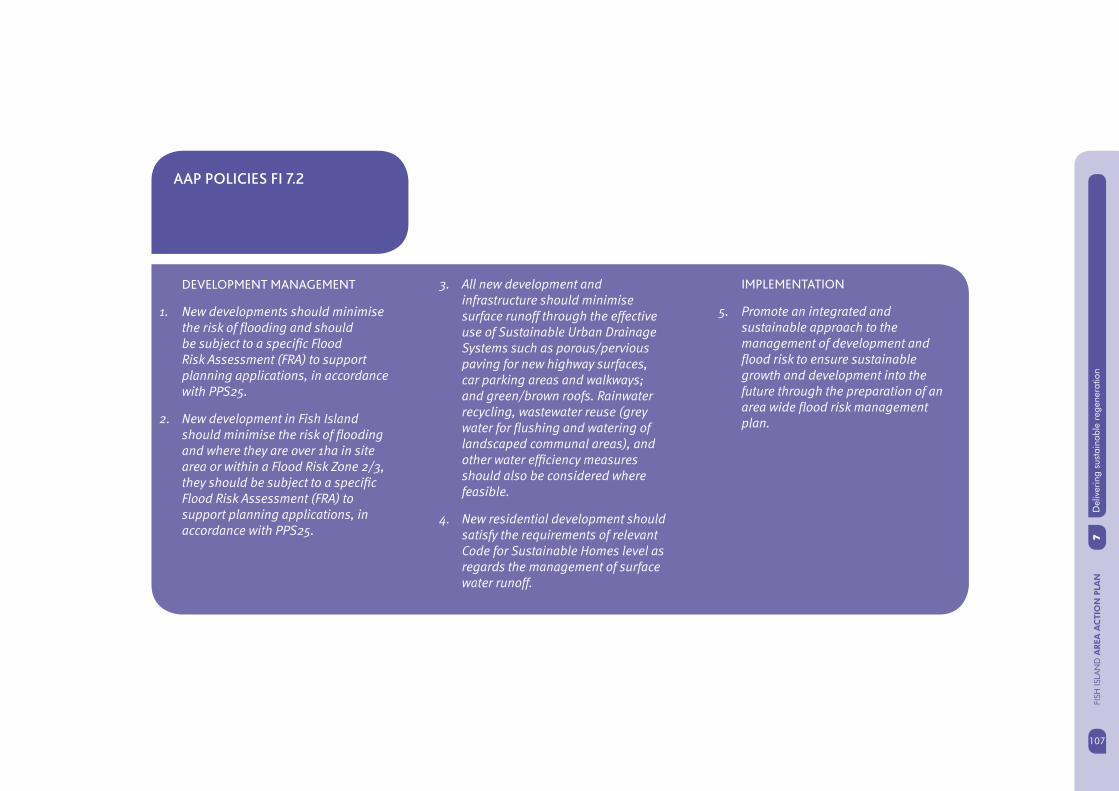
107
7D
eliv
erin
g su
stai
nabl
e re
gene
ratio
n
107
FISH
ISLA
ND
AREA
AC
TIO
N P
LAN
AAP POLICIES FI 7.2
DEVELOPMENT MANAGEMENT
1. New developments should minimise the risk of fl ooding and should be subject to a specifi c Flood Risk Assessment (FRA) to support planning applications, in accordance with PPS25.
2. New development in Fish Island should minimise the risk of fl ooding and where they are over 1ha in site area or within a Flood Risk Zone 2/3, they should be subject to a specifi c Flood Risk Assessment (FRA) to support planning applications, in accordance with PPS25.
3. All new development and infrastructure should minimise surface runoff through the effective use of Sustainable Urban Drainage Systems such as porous/pervious paving for new highway surfaces, car parking areas and walkways; and green/brown roofs. Rainwater recycling, wastewater reuse (grey water for fl ushing and watering of landscaped communal areas), and other water effi ciency measures should also be considered where feasible.
4. New residential development should satisfy the requirements of relevant Code for Sustainable Homes level as regards the management of surface water runoff.
IMPLEMENTATION
5. Promote an integrated and sustainable approach to the management of development and fl ood risk to ensure sustainable growth and development into the future through the preparation of an area wide fl ood risk management plan.

7D
eliv
erin
g su
stai
nabl
e re
gene
ratio
nFI
SH IS
LAN
D A
REA
AC
TIO
N P
LAN
108
DELIVERING THE AAP
7.14 Planning for the delivery of the proposals described within the draft Fish Island AAP is particularly important because of the many land owners, stakeholders, organisations and partners involved. The AAP vision also relies on the delivery of signifi cant infrastructure projects, such as new bridges, station improvements and public realm enhancement. Transforming parts of Fish Island to provide new housing will depend on the provision of social and community facilities to respond to the growth anticipated, such as new schools or health facilities.
7.15 Development coming forward as part of the Olympic and Paralympic Games and the delivery of the legacy by the Olympic Park Legacy Company (OPLC) needs to be managed and coordinated to compliment delivery of the non Olympic projects and development within Fish Island. Most of the area in the Olympic Park, including Fish Island East will not be available for development until 2013.
WORKING WITH PARTNERS
7.16 The Council has worked successfully with partners including London Thames Gateway Development Corporation and the London Development Agency to deliver and secure funding for pre-Olympic projects in Fish Island and will continue to do so.
7.17 New arrangements for planning and regeneration in the Lower Lea Valley will come into place during the lifetime of the Area Action Plan. LTGDC will cease operations in 2012/13. The Mayor of London has published consultation proposals for a Mayoral Development Corporation (MDC) to be known as the Olympic Park Legacy Corporation.
7.18 The proposed MDC boundary will include Fish Island and the new body would take on assets and projects from the LTGDC, Olympic Park Legacy Company and other organisations working in this area. The MDC could also have powers for plan making and determining planning applications. The Council will seek to establish a positive and effective working relationship with the proposed MDC (or other successor bodies) to drive forward the vision in the AAP.
DEVELOPMENT MANAGEMENT
7.19 The Area Action Plan will be a material consideration in determining planning applications within Fish Island, alongside the Core Strategy, other DPDs and the London Plan. The weight attached to the draft AAP will increase as it progresses towards the submission stage.
7.20 The Council has a positive and collaborative approach to development management and encourages anyone considering making an application for planning permission to take advantage of the pre-application advice service. Structured pre-application discussions help to provide certainty over the likelihood of planning permission being granted and help to iron out diffi cult planning issues at an early stage in the development design process.
7.21 In Fish Island, applications for certain larger scale developments are determined by London Thames Gateway Development Corporation or the Olympic Delivery Authority. Both of these organisations offer pre-application advice which is often provided jointly with the Council. In future it is likely that the development management functions will be taken over by the proposed Mayoral Development Corporation.
109
7D
eliv
erin
g su
stai
nabl
e re
gene
ratio
n
109
FISH
ISLA
ND
AREA
AC
TIO
N P
LAN
DEVELOPMENT PHASING
7.22 Development in Fish Island will be incremental and driven largely by the market and prevailing economic conditions. It is possible that the vision set out in the AAP will not be realised fully within the fi rst 15 years. Most land in Fish Island is in private ownership and the pattern of ownership is varied and complex. This presents a challenge to achieving comprehensive development.
7.23 The Council and its partners will encourage land owners to work collaboratively to achieve the best possible outcomes in delivering the vision in Fish Island. The Council and its partners will help to facilitate this process where possible by assisting with negotiations and by working closely with everyone who has an interest in delivering the agreed vision.
OPPORTUNITY SITES
7.26 There are a number of sites across Fish Island that are suitable for redevelopment (subject to certain constraints) and where the size and location of the site means that they are strategically important in realising the overall vision for the area. These include:
Sites north of White Post Lane, • adjacent to London Overground railway
McGrath Waste Transfer Site, Trego • Road
Neptune Wharf (former Scottish and • Newcastle brewery), Wyke Road;
Former Warehouses Bream Street•
Site north of Wick Lane •
These sites are shown on fi g 7.2.
7.24 Phasing of development should be linked closely to the delivery of infrastructure and public transport improvements. A detailed phasing strategy will be produced at the next stage following public consultation. In general, phasing of new development will be based on the key principles of:
Development in Fish Island North • linked to station infrastructure improvements
Development in mid Fish Island linked • to improved north south connections including new connections across the Hertford Union Canal
Development in Fish Island East linked • to commitments for new bridges across the Lea Navigation.
7.25 All new development in Fish Island will be expected to contribute to improving vital connections across the A12 to ensure Fish Island becomes an integrated part of Tower Hamlets.

7D
eliv
erin
g su
stai
nabl
e re
gene
ratio
nFI
SH IS
LAN
D A
REA
AC
TIO
N P
LAN
110
Figure 7.2: Location plan of opportunity sites
7.27 The following sections describe how the key AAP principles could be applied to the opportunity sites. This guidance is strategic and detailed site development briefs should be prepared either by the owners or local planning authority. This guidance is not exhaustive and development proposals will need to take into account other national, regional and local planning policies.
Key
Fish Island Area Action Plan Boundary
Opportunity sites
White Post Lane
McGrath Site
Neptune Wharf
Former Wharehouses, Bream Street
415 Wick Lane
Olympic Legacy Opportunity Sites
A12
1
2
3
4
5
Waterw
orks River
City Mill River
Ha
ckn
ey C
ut
Hertford
Unio
n Canal
Rive
r Lee
Na
viga
tion
STRATFORDINTERNATIONAL
RAIL
WICK LANE
MAVERTON ROAD
WHITE POST LANE
BEACHY ROAD
BR
EA
M S
TRE
ET
WYKE R
OAD
STOUR ROAD
DACE ROAD
SM
EE
D R
OA
D
HEPSC
OTT RO
AD
ICELAND ROAD
OLD FORD ROAD A 12
BLACKWALL TUNNEL NORTHERN APPROACH
A 1
2
OLYMPICSTADIUM
VICTORIA PARK
EAST CROSS ROUTE
MUSV
ENERGYCENTRE
STRATFORDINTERNATIONAL
HACKNEY WICK
PUDDING MILL LANE
WA
LLIS
RO
AD
BER
KS
HIR
E RO
AD
STRATFORDCITY
ROMAN ROAD
1
2
3
4
5
STRATFORD
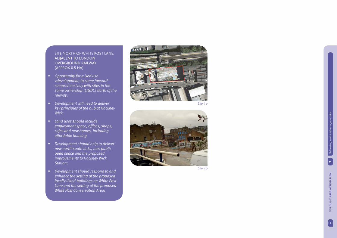
111
7D
eliv
erin
g su
stai
nabl
e re
gene
ratio
n
111
FISH
ISLA
ND
AREA
AC
TIO
N P
LAN
SITE NORTH OF WHITE POST LANE,
ADJACENT TO LONDON
OVERGROUND RAILWAY
(APPROX 0.5 HA)
• Opportunity for mixed use vdevelopment, to come forward comprehensively with sites in the same ownership (LTGDC) north of the railway;
• Development will need to deliver key principles of the hub at Hackney Wick;
• Land uses should include employment space, offi ces, shops, cafes and new homes, including affordable housing
• Development should help to deliver new north-south links, new public open space and the proposed improvements to Hackney Wick Station;
• Development should respond to and enhance the setting of the proposed locally listed buildings on White Post Lane and the setting of the proposed White Post Conservation Area;
Site 1a
Site 1b

7D
eliv
erin
g su
stai
nabl
e re
gene
ratio
nFI
SH IS
LAN
D A
REA
AC
TIO
N P
LAN
112
MCGRATH WASTE TRANSFER SITE,
TREGO ROAD (APPROX 2.86 HA)
• Site cannot come forward until policies that safeguard waste sites in the London Plan and TH Core Strategy can be satisfi ed;
• Opportunity for mixed use development including employment uses, galleries; residential, affordable housing, community uses and small scale retail;
• Opportunity to provide signifi cant public open space to serve the wider area, up to 1 ha green space;
• Development should provide new walking and cycling routes through the site providing connections to the Hertford Union canal tow path and Roach Point bridge;
• Development should respond positively to the waterside setting, enhance the character of the canal and enhance strategic views west towards central London;
• Proposals should provide a high quality frontage and deliver public realm improvements to Wansbeck Road;
• Opportunity to improve north south connections across the canal;
• Form of development needs to be considered jointly with the Neptune Wharf site opposite
Site 2a
Site 2b
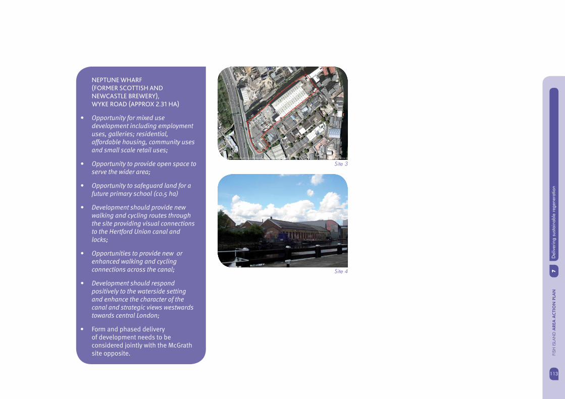
113
7D
eliv
erin
g su
stai
nabl
e re
gene
ratio
n
113
FISH
ISLA
ND
AREA
AC
TIO
N P
LAN
Site 3
Site 4
NEPTUNE WHARF
(FORMER SCOTTISH AND
NEWCASTLE BREWERY),
WYKE ROAD (APPROX 2.31 HA)
• Opportunity for mixed use development including employment uses, galleries; residential, affordable housing, community uses and small scale retail uses;
• Opportunity to provide open space to serve the wider area;
• Opportunity to safeguard land for a future primary school (c0.5 ha)
• Development should provide new walking and cycling routes through the site providing visual connections to the Hertford Union canal and locks;
• Opportunities to provide new or enhanced walking and cycling connections across the canal;
• Development should respond positively to the waterside setting and enhance the character of the canal and strategic views westwards towards central London;
• Form and phased delivery of development needs to be considered jointly with the McGrath site opposite.
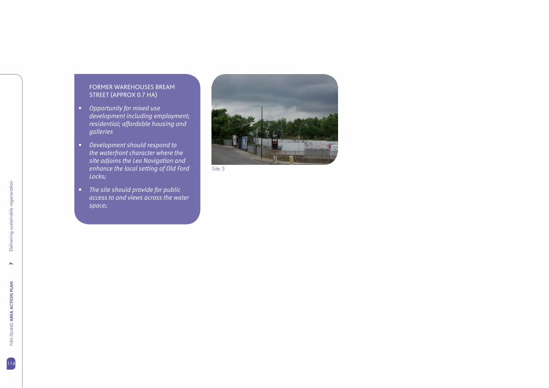
7D
eliv
erin
g su
stai
nabl
e re
gene
ratio
nFI
SH IS
LAN
D A
REA
AC
TIO
N P
LAN
114
FORMER WAREHOUSES BREAM
STREET (APPROX 0.7 HA)
• Opportunity for mixed use development including employment; residential; affordable housing and galleries
• Development should respond to the waterfront character where the site adjoins the Lea Navigation and enhance the local setting of Old Ford Locks;
• The site should provide for public access to and views across the water space;
Site 5

115
7D
eliv
erin
g su
stai
nabl
e re
gene
ratio
n
115
FISH
ISLA
ND
AREA
AC
TIO
N P
LAN
7.30 It is likely that public sector funding for major infrastructure projects such as those required to deliver the AAP vision will become more constrained over the coming years. The role of developer contributions through planning obligations (Section 106 agreements) and the future introduction of a Community Infrastructure Levy will become increasingly important in providing vital resources to help deliver the necessary infrastructure to make development both possible and sustainable.
7.31 The Council will explore different options for the use of developer contributions either through the pooling of resources secured through S106 planning obligations on groups of up to fi ve sites (as allowed by current Community Infrastructure Levy Regulations); through a borough wide Community Infrastructure Levy (CIL) or through targeting of the proposed MDC CIL powers.
FUNDING AND DELIVERING
INFRASTRUCTURE
7.28 LTGDC has begun working with Network Rail and Transport for London to look at delivery options for the proposed station improvements. The Olympic Park Legacy Company has made commitments to deliver key bridge connections across the Lea Navigation, some of which will come forward before the Games in 2012.
7.29 The Council supports these initiatives and will work with the proposed MDC or successor body to maintain momentum on the Hackney Wick Station improvements and ensure that commitments to provide bridges across the Lea Navigation through the Olympic Legacy development are honoured.
7.32 The fi nal AAP will include a detailed implementation plan. A key role of the Implementation Plan will be to identify the funds needed to deliver projects, set out relative priorities and to seek funding from a variety of sources.
7.33 The Implementation Plan will form the basis of a ‘rolling programme’ of projects and tasks that will be continually updated to refl ect projects completed and new projects initiated, whether these are led by the Council, LTGDC the proposed MDC, private developers or other key partners.

7D
eliv
erin
g su
stai
nabl
e re
gene
ratio
nFI
SH IS
LAN
D A
REA
AC
TIO
N P
LAN
116
NEXT STEPS
7.35 The preferred submission version of the draft AAP will be subject to public consultation for a 6 week period over December 2011 and January 2012. This is a formal consultation and is known as the call for representations. The representations received will help to inform what further work will be required to take the AAP to fi nal adoption stage. It is likely that the agreed vision and development principles set out in the AAP will need to be supported by an assessment of development viability, further environmental studies, detailed development briefs for key strategic sites and complimentary regeneration strategies such as an inward investment plan.
MONITORING
7.34 The development principles and actions outlined in the AAP will be monitored against the indicators for relevant policies contained in the Core Strategy and against new indicators specifi c to the AAP developed at the fi nal adoption stage. Progress against the agreed development principles will be reported as part of the Council’s LDF Annual Monitoring Report.
7.36 Further feasibility and design work will be carried out to test the proposals for new infrastructure such as bridge connections, sites for schools and open space and the waste to energy opportunity.
7.37 Publication of this draft engagement document is an important step towards achieving a sustainable and deliverable future for Fish Island.

117
8A
ppen
dix
117
FISH
ISLA
ND
AREA
AC
TIO
N P
LAN
Appendix 1
08

8A
ppen
dix
FISH
ISLA
ND
AREA
AC
TIO
N P
LAN
118
APPENDIX
APPENDIX 1
Author Publication Year
British Waterways Lower Lea Valley Waterspace Strategy (Draft) 2011
British Waterways and English Heritage
Promoting high quality waterside development 2009
GLA Housing in London 2008
GLA Industrial Land Study
GLA London Plan 2011
LBH Hackney Wick / Fish Island Masterplan Baseline and Stage 2 Report 2008
LBH Hackney Wick Phase 1 Area Action Plan 2010
LBTH Core Strategy 2010
LBTH Borough Portrait of Tower Hamlets 2009
LBTH Local Economic Assessment 2010
LBTH Retail and Leisure Capacity Study 2009
LBTH Town Centre Spatial Strategy 2009
LBTH Unique Selling Point Study 2010
LBTH Employment Land Study Final
LBTH Housing Strategy 2009
LBTH Infrastructure Delivery Plan 2009
LBTH Local Economic Assessment 2011
LBTH Making Connected Places 2008
LBTH Managing Development DPD (Draft) 2011
LBTH Planning for Population Change and Growth Capacity Assessment –Baseline Report 2009
LBTH Public transport capacity statement 2006
Evidence base which supports the Fish Island Area Action Plan
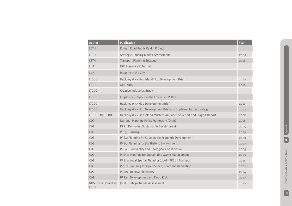
119
8A
ppen
dix
119
FISH
ISLA
ND
AREA
AC
TIO
N P
LAN
Author Publication Year
LBTH Roman Road Public Realm Project
LBTH Strategic Housing Market Assessment 2009
LBTH Transport Planning Strategy 2011
LDA HWFI Creative Potential
LDA Industry in the City
LTGDC Hackney Wick Fish Island Hub Development Brief 2010
LTGDC A12 Study 2010
LTGDC Creative Industries Study
LTGDC Employment Space in the Lower Lea Valley
LTGDC Hackney Wick Hub Development Brief 2010
LTGDC Hackney Wick Hub Development Brief and Implementation Strategy 2010
LTGDC/LBTH/LBH Hackney Wick Fish Island Masterplan Baseline Report and Stage 2 Report 2008
CLG National Planning Policy Framework (Draft) 2011
CLG PPS1: Delivering Sustainable Development 2005
CLG PPS3: Housing 2005
CLG PPS4: Planning for Sustainable Economic Development 2009
CLG PPS5: Planning for the Historic Environment 2010
CLG PPS9: Biodiversity and Geological Conservation 2005
CLG PPS10: Planning for Sustainable Waste Management 2005
CLG PPS12: Local Spatial Planning (2008) PPS13: Transport 2011
CLG PPS17: Planning for Open Space, Sport and Recreation 2002
CLG PPS22: Renewable Energy 2004
CLG PPS25: Development and Flood Risk 2010
NHS Tower Hamlets/LBTH
Joint Strategic Needs Assessment 2010
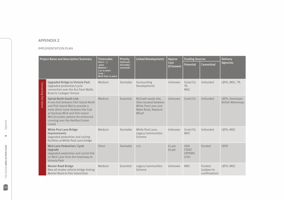
8A
ppen
dix
FISH
ISLA
ND
AREA
AC
TIO
N P
LAN
120
APPENDIX 2
Project Name and Description/Summary TimescalesShort – 3 yearsMedium – 3 to 10 yearsLong – More than 10 years
Priority(Optional/ desirable/ essential)
Linked Developments Approx Cost (if known)
Funding Sources Delivery Agencies
Potential Committed
Upgraded Bridge to Victoria ParkUpgraded pedestrian/cycle connection over the A12 from Wallis Road to Cadogan Terrace
Medium Desirable Surrounding Developments
Unknown S106/CILTfLMDC
Unfunded LBTH, MDC, TfL
Spinal North-South LinkA new link between Fish Island North and Fish Island Mid to provide a more direct route between the hub at Hackney Wick and Fish Island Mid (includes options for enhanced crossing over the Hertford Union Canal)
Medium Essential McGrath waste site, Sites located between White Post Lane and Wyke Road, Neptune Wharf
Unknown S106/CIL Unfunded LBTH, Developer, British Waterways
White Post Lane Bridge ImprovementsUpgraded pedestrian and cycling facilities at White Post Lane bridge
Medium Desirable White Post Lane, Legacy Communities Scheme
Unknown S106/CILMDC
Unfunded LBTH, MDC
Wick Lane Pedestrian/ Cycle UpgradeUpgraded pedestrian and cyclist link on Wick Lane from the Greenway to Victoria Park
Short Desirable n/a £1.9m£119k
ODALTGDCOPTEMSLCN+
Funded LBTH
Monier Road BridgeNew all modes vehicle bridge linking Monier Road to Fish Island East
Medium Essential Legacy Communities Scheme
Unknown MDC Funded (subject to confi rmation)
LBTH, MDC
Connecting Fish Island
IMPLEMENTATION PLAN
Implementation plan
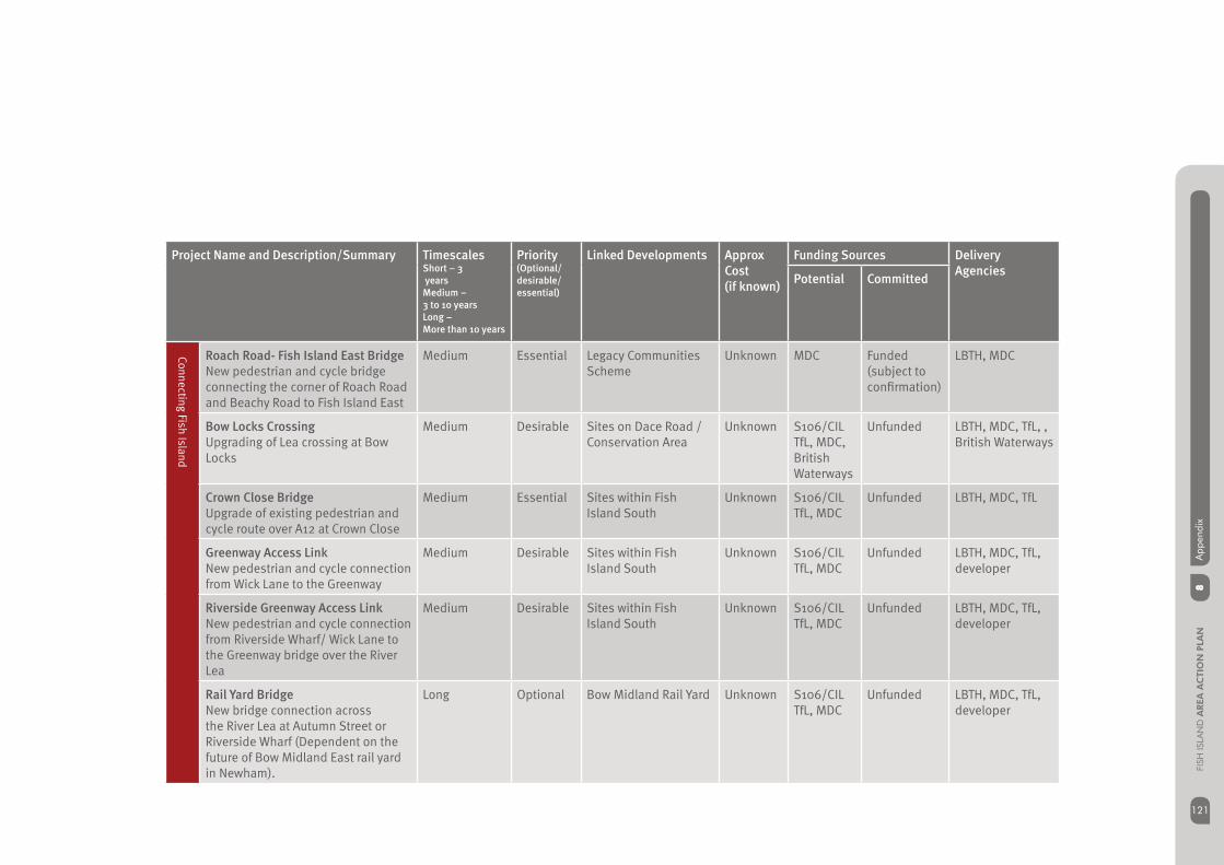
121
8A
ppen
dix
121
FISH
ISLA
ND
AREA
AC
TIO
N P
LAN
Project Name and Description/Summary TimescalesShort – 3 yearsMedium – 3 to 10 yearsLong – More than 10 years
Priority(Optional/ desirable/ essential)
Linked Developments Approx Cost (if known)
Funding Sources Delivery Agencies
Potential Committed
Roach Road- Fish Island East BridgeNew pedestrian and cycle bridge connecting the corner of Roach Road and Beachy Road to Fish Island East
Medium Essential Legacy Communities Scheme
Unknown MDC Funded (subject to confi rmation)
LBTH, MDC
Bow Locks CrossingUpgrading of Lea crossing at Bow Locks
Medium Desirable Sites on Dace Road / Conservation Area
Unknown S106/CILTfL, MDC, British Waterways
Unfunded LBTH, MDC, TfL, , British Waterways
Crown Close BridgeUpgrade of existing pedestrian and cycle route over A12 at Crown Close
Medium Essential Sites within Fish Island South
Unknown S106/CIL TfL, MDC
Unfunded LBTH, MDC, TfL
Greenway Access LinkNew pedestrian and cycle connection from Wick Lane to the Greenway
Medium Desirable Sites within Fish Island South
Unknown S106/CILTfL, MDC
Unfunded LBTH, MDC, TfL, developer
Riverside Greenway Access LinkNew pedestrian and cycle connection from Riverside Wharf/ Wick Lane to the Greenway bridge over the River Lea
Medium Desirable Sites within Fish Island South
Unknown S106/CILTfL, MDC
Unfunded LBTH, MDC, TfL, developer
Rail Yard BridgeNew bridge connection across the River Lea at Autumn Street or Riverside Wharf (Dependent on the future of Bow Midland East rail yard in Newham).
Long Optional Bow Midland Rail Yard Unknown S106/CIL TfL, MDC
Unfunded LBTH, MDC, TfL, developer
Connecting Fish Island
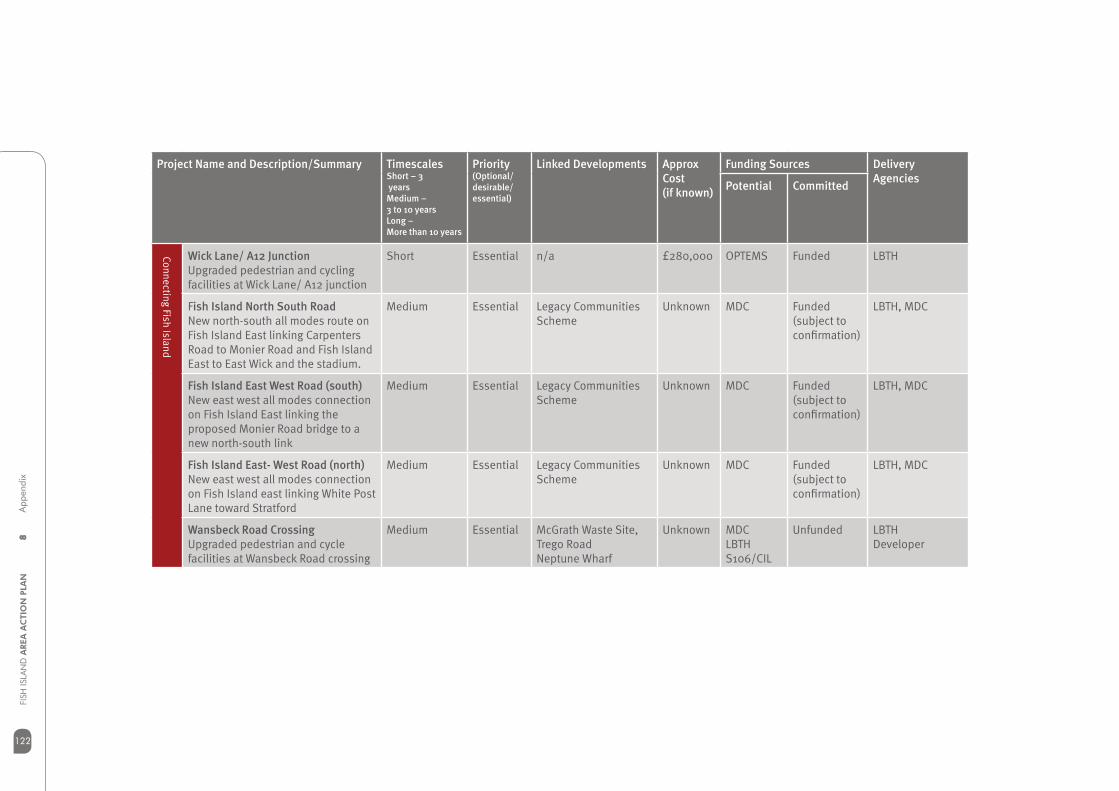
8A
ppen
dix
FISH
ISLA
ND
AREA
AC
TIO
N P
LAN
122
Project Name and Description/Summary TimescalesShort – 3 yearsMedium – 3 to 10 yearsLong – More than 10 years
Priority(Optional/ desirable/ essential)
Linked Developments Approx Cost (if known)
Funding Sources Delivery Agencies
Potential Committed
Wick Lane/ A12 JunctionUpgraded pedestrian and cycling facilities at Wick Lane/ A12 junction
Short Essential n/a £280,000 OPTEMS Funded LBTH
Fish Island North South RoadNew north-south all modes route on Fish Island East linking Carpenters Road to Monier Road and Fish Island East to East Wick and the stadium.
Medium Essential Legacy Communities Scheme
Unknown MDC Funded (subject to confi rmation)
LBTH, MDC
Fish Island East West Road (south)New east west all modes connection on Fish Island East linking the proposed Monier Road bridge to a new north-south link
Medium Essential Legacy Communities Scheme
Unknown MDC Funded (subject to confi rmation)
LBTH, MDC
Fish Island East- West Road (north)New east west all modes connection on Fish Island east linking White Post Lane toward Stratford
Medium Essential Legacy Communities Scheme
Unknown MDC Funded (subject to confi rmation)
LBTH, MDC
Wansbeck Road CrossingUpgraded pedestrian and cycle facilities at Wansbeck Road crossing
Medium Essential McGrath Waste Site,Trego Road Neptune Wharf
Unknown MDCLBTHS106/CIL
Unfunded LBTHDeveloper
Connecting Fish Island
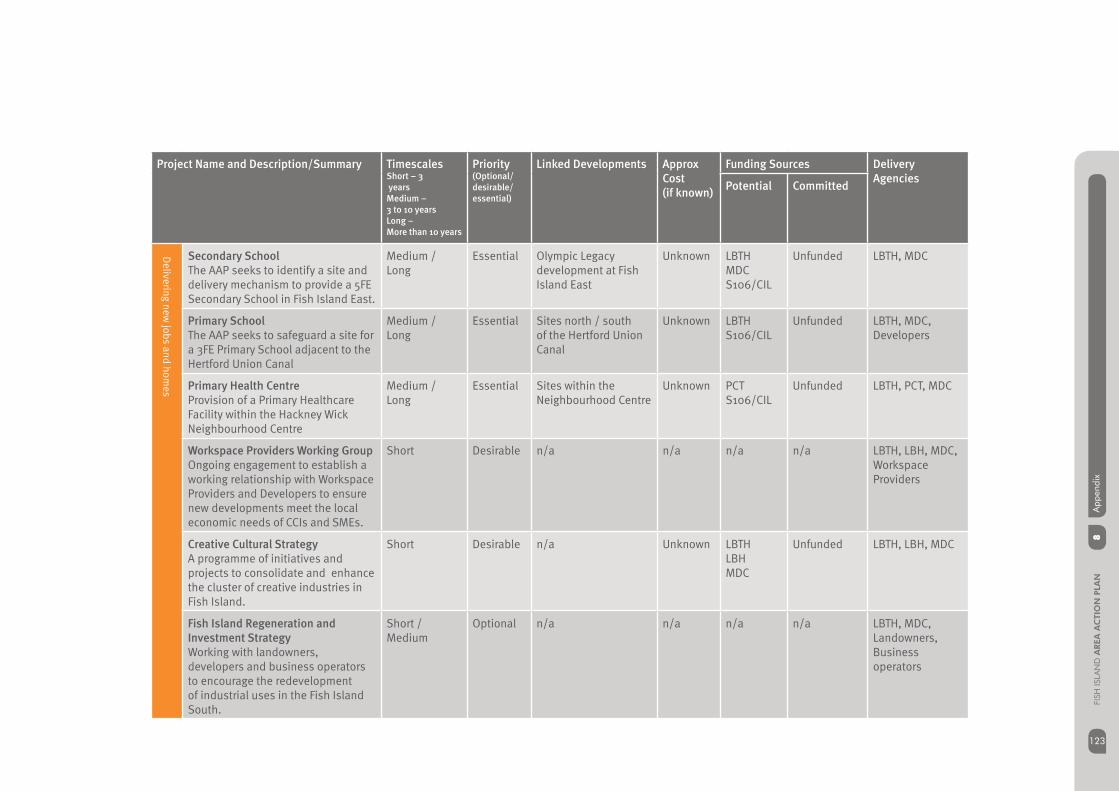
123
8A
ppen
dix
123
FISH
ISLA
ND
AREA
AC
TIO
N P
LAN
Project Name and Description/Summary TimescalesShort – 3 yearsMedium – 3 to 10 yearsLong – More than 10 years
Priority(Optional/ desirable/ essential)
Linked Developments Approx Cost (if known)
Funding Sources Delivery Agencies
Potential Committed
Secondary SchoolThe AAP seeks to identify a site and delivery mechanism to provide a 5FE Secondary School in Fish Island East.
Medium / Long
Essential Olympic Legacy development at Fish Island East
Unknown LBTHMDCS106/CIL
Unfunded LBTH, MDC
Primary SchoolThe AAP seeks to safeguard a site for a 3FE Primary School adjacent to the Hertford Union Canal
Medium / Long
Essential Sites north / south of the Hertford Union Canal
Unknown LBTHS106/CIL
Unfunded LBTH, MDC, Developers
Primary Health CentreProvision of a Primary Healthcare Facility within the Hackney Wick Neighbourhood Centre
Medium / Long
Essential Sites within the Neighbourhood Centre
Unknown PCTS106/CIL
Unfunded LBTH, PCT, MDC
Workspace Providers Working Group Ongoing engagement to establish a working relationship with Workspace Providers and Developers to ensure new developments meet the local economic needs of CCIs and SMEs.
Short Desirable n/a n/a n/a n/a LBTH, LBH, MDC, Workspace Providers
Creative Cultural Strategy A programme of initiatives and projects to consolidate and enhance the cluster of creative industries in Fish Island.
Short Desirable n/a Unknown LBTHLBHMDC
Unfunded LBTH, LBH, MDC
Fish Island Regeneration and Investment StrategyWorking with landowners, developers and business operators to encourage the redevelopment of industrial uses in the Fish Island South.
Short / Medium
Optional n/a n/a n/a n/a LBTH, MDC,Landowners,Business operators
Delivering new
jobs and homes

8A
ppen
dix
FISH
ISLA
ND
AREA
AC
TIO
N P
LAN
124
Project Name and Description/Summary TimescalesShort – 3 yearsMedium – 3 to 10 yearsLong – More than 10 years
Priority(Optional/ desirable/ essential)
Linked Developments Approx Cost (if known)
Funding Sources Delivery Agencies
Potential Committed
Hackney Wick StationComprehensive redevelopment of Hackney Wick Station, linked to surrounding developments and creation of a public square and north/south route.
Medium Essential White Post Lane £10m LTGDC/MDCS106/SILTfL/LULNetwork Rail
Unfunded LBTH, TfL/LUL, LBH, MDC, Network Rail
Development briefs for opportunity sitesFurther detailed planning and design guidance, to fully realise the development potential of key sites, and to ensure comprehensive delivery of the necessary infrastructure to support development in the area.
Short / Medium
Desirable Sites notrth of WhitePost Lane McGrath Waste Site,Trego RoadNeptune WharfFormer Warehouses,Bream StreetSite north of WickLane
Unknown LBTH Unfunded LBTH
Industrial Design GuidanceDetailed design guidance for the LIL and SIL to guide and support the redevelopment of the area, providing a range of different types of industrial premises, which can site alongside other uses.
Short / Medium
Desirable Sites located within LIL and SIL
Unknown LBTH, MDCDfL
Unfunded LBTH MDCDfL
Wansbeck Road Corridor to improve the overall environmental quality and experience for cyclists and pedestrians.
Short / Medium
Essential McGrath Waste Site,Trego RoadNeptune Wharf
Unknown LBTH, MDCS106/CIL
OPLC LBTHDeveloper
A hub at H
ackney Wick
Creating a high quality environment

125
8A
ppen
dix
125
FISH
ISLA
ND
AREA
AC
TIO
N P
LAN
Project Name and Description/Summary TimescalesShort – 3 yearsMedium – 3 to 10 yearsLong – More than 10 years
Priority(Optional/ desirable/ essential)
Linked Developments Approx Cost (if known)
Funding Sources Delivery Agencies
Potential Committed
Crown Close and Wick Lane Enhance the quality and experience of the key connection across the A12, to mitigate the impact of traffi c related to industrial uses on Wick Lane and to improve pedestrian and cycle links across the A12.
Short / Medium
Essential Sites within Fish Island South
Unknown LBTH, MDC,S106/CIL
LTGDC LBTHDeveloper
Dace Road and Old Ford Lock Improve the setting of Fish IslandConservation Area, the buildings within, and the setting of the historic locks through public realm enhancements and wayfi nding.
Short / Medium
Essential Dace Road / Conservation Area
Unknown LBTH, MDC, British Waterways
OPLC LBTHBritish WaterwaysDeveloper
Monier RoadEnhance the future role of this connection to Fish Island East and to complement proposed junction alterations at Monier Road and Wansbeck Road.
Short / Medium
Essential Sites on Monier Road Unknown LBTH, MDC, S106/CIL
Unfunded LBTHDeveloper
Wallis Road Strengthen the key route from Victoria Park and future Queen Elizabeth Park, by enhance the pedestrian and cycle environment.
Short / Medium
Essential Sites on Wallis Road Unknown LBTHS106/CIL
LTGDC LBTHDeveloper
White Post Lane and Rothbury RoadImprove the setting of the proposed Conservation Area and building of local signifi cance. Enhancements to assist with the delivery of the proposed station and new north/south link to create a public square.
Short / Medium
Essential Sites north south of White Post Lane and Rothbury Road
LBTHMDCS106/CIL
Unfunded LBTHDeveloper
Creating a high quality environment

8A
ppen
dix
FISH
ISLA
ND
AREA
AC
TIO
N P
LAN
126
APPENDIX 3
MANAGED WORKSPACE GUIDELINES
The vision in the Fish Island AAP, seeks to support, retain and enhance micro and small businesses, particular in the creative and cultural sector, that forms part and complements the existing character of the area. Further guidance is required to guide employment regeneration of this nature in the area.
This appendix sets out Managed Workspace Guidelines for the general management, design and delivery principles for B1 employment workspace. The principles contained within this section is supplementary to Fish Island AAP, which will assist developers and other stakeholders to deliver the employment policies within the Fish Island AAP. Proposals delivering employment workspace as part of new developments in the Fish Island area, should apply the principles contained within this guidance.
Securing and Delivering Employment Workspaces
Partnership working - Developers are encouraged to work with Managed Workspace Providers to ensure that employment workspace is fl exible and response to the local economic needs of micro and small businesses, when considering employment proposals. Early discussion with Managed Workspace Providers, will ensure that proposals are viable and sustainable, to meet the needs of the local economy.
Acme Studios
SPACE
Mother Studios
Urban Space
Workspace Group
Bow Arts Trust
Chisenhale Art Place
Acava
Shoreditch Trust
Stourspace
*This is not an exhaustive list
Employment type and quantum - Successful employment workspace projects could range in scale. New developments incorporating employment will be encouraged to provide a minimum of 500 sqm of fl exible employment workspace. This amounts to typically 20 to 25 workspaces, to provide suffi cient critical mass to enable the development of a viable business plan to deliver and manage workspaces, and to ensure an appropriate and sustainable environment for networking and local facilities to assist with economic growth.

127
8A
ppen
dix
127
FISH
ISLA
ND
AREA
AC
TIO
N P
LAN
EXAMPLE PROJECTS
Leven Road London, E14 Bridget Riley and Britannia, Fish Island Bow Road Studios, E3
LEVEN ROAD LONDON, E14
Description
Mixed-use development comprising 21 self-contained studios ranging from 18.1 to 35.3 sqm per unit and 66 affordable housing units.
Partnership
Swan Housing and Acmehttp://www.acme.org.uk/leven.php
BRIDGET RILEY AND BRITANNIA, FISH ISLAND
Description
Conversion of a historic peanut factory in Fish Island which provides 37 studios in Bridget Riley Studios and 55 studios in Britannia. Units vary in size.
Partnership
Cultural-led regeneration of two historic buildings. SPACE have a long term lease on both sites.http://www.spacestudios.org.uk/studios/studio-sites/bridget-riley-studios-e3
BOW ROAD STUDIOS, E3
Description
Two large adjacent buildings on Bow Road, comprising 90 artist studios. Studios are self contained, with open plan communal areas. The studios cover a wide range of sizes and are suitable for a range of different art practices.
Partnership
Delivered and managed by Bow Arts Trusthttp://www.bowarts.org/studios/bow-road-studios
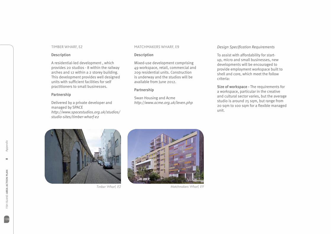
8A
ppen
dix
FISH
ISLA
ND
AREA
AC
TIO
N P
LAN
128
Timber Wharf, E2 Matchmakers Wharf, E9
TIMBER WHARF, E2
Description
A residential-led development , which provides 20 studios - 8 within the railway arches and 12 within a 2 storey building. This development provides well designed units with suffi cient facilities for self practitioners to small businesses.
Partnership
Delivered by a private developer and managed by SPACEhttp://www.spacestudios.org.uk/studios/studio-sites/timber-wharf-e2
MATCHMAKERS WHARF, E9
Description
Mixed-use development comprising 49 workspace, retail, commercial and 209 residential units. Construction is underway and the studios will be available from June 2012.
Partnership
Swan Housing and Acmehttp://www.acme.org.uk/leven.php
Design Specifi cation Requirements
To assist with affordability for start-up, micro and small businesses, new developments will be encouraged to provide employment workspace built to shell and core, which meet the follow criteria:
Size of workspace - The requirements for a workspace, particular in the creative and cultural sector varies, but the average studio is around 25 sqm, but range from 20 sqm to 100 sqm for a fl exible managed unit.
129
8A
ppen
dix
129
FISH
ISLA
ND
AREA
AC
TIO
N P
LAN
Unit design and access - There is no blueprint for a workspace unit, but generally there are typical requirements that can accommodate a fl exible workspace, such as;
Self-contained•
Higher ceilings than normal offi ce or • domestic space
Good natural lighting and ventilation•
Shared supporting facilities such as • telecommunication networks, and other equipment including broadband
DDA complaint design and access •
Good security with 24 hour access•
Managing Flexible Workspaces
Lease Arrangements – A key component for sustainable workspaces is security and fl exibility - ‘easy-in, easy-out’ lease terms. The ability to adapt to a sudden change of circumstances, and the scope to terminate a lease at short notice, is desirable for many micro and small businesses. The fl exibility, coupled with a long term lease so that micro and small businesses can plan ahead is encouraged.
REFERENCE DOCUMENTS
Artist’s Studios: A guide to securing, supporting and creating affordable studio in Loncon, 2007, Capital Studios – the London Artists’ Studios Development Programme and Acme
Industry in the City, LDA, 2006
Investing in Creative Communities, The Provision of Affordable of Artists’ Studios -A role for Spatial Planning, 2011, National Federation of Artists’
Studio Providers,
London’s creative workforce, 2009 (update), GLA
Working Paper 40: London’s creative workforce, 2010 (update), GLA

8A
ppen
dix
FISH
ISLA
ND
AREA
AC
TIO
N P
LAN
130
London Borough of Tower Hamlets
Anchorage House
Clove Crescent
London E14 2BG
020 7364 2502
www.towerhamlets.gov.uk