Finding The “Kam Zero” · downed Japanese plane crashed into the ordnance machine shop. The...
17
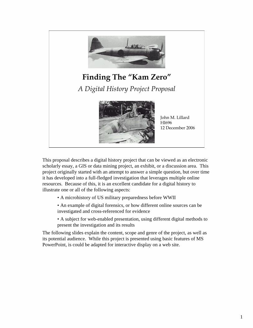
1 Finding The “Kam Zero” A Digital History Project Proposal John M. Lillard HI696 12 December 2006 This proposal describes a digital history project that can be viewed as an electronic scholarly essay, a GIS or data mining project, an exhibit, or a discussion area. This project originally started with an attempt to answer a simple question, but over time it has developed into a full-fledged investigation that leverages multiple online resources. Because of this, it is an excellent candidate for a digital history to illustrate one or all of the following aspects: • A microhistory of US military preparedness before WWII • An example of digital forensics, or how different online sources can be investigated and cross-referenced for evidence • A subject for web-enabled presentation, using different digital methods to present the investigation and its results The following slides explain the content, scope and genre of the project, as well as its potential audience. While this project is presented using basic features of MS PowerPoint, is could be adapted for interactive display on a web site.
Transcript of Finding The “Kam Zero” · downed Japanese plane crashed into the ordnance machine shop. The...
1
Finding The “Kam Zero”A Digital History Project Proposal
John M. LillardHI69612 December 2006
This proposal describes a digital history project that can be viewed as an electronic scholarly essay, a GIS or data mining project, an exhibit, or a discussion area. This project originally started with an attempt to answer a simple question, but over time it has developed into a full-fledged investigation that leverages multiple online resources. Because of this, it is an excellent candidate for a digital history to illustrate one or all of the following aspects:
• A microhistory of US military preparedness before WWII• An example of digital forensics, or how different online sources can be investigated and cross-referenced for evidence• A subject for web-enabled presentation, using different digital methods to present the investigation and its results
The following slides explain the content, scope and genre of the project, as well as its potential audience. While this project is presented using basic features of MS PowerPoint, is could be adapted for interactive display on a web site.

2
Wreckage of the Kam Zero
• Where did it crash? Into Quarters #1?• Why and how did it crash?• Where is it now?• Who was the pilot, and what happened to him?
Typical Ft KamOfficer’s Quarters
Note similar roof and window styles
On December 7th, 1941, a Japanese Mitsubishi Type O (“Zero”) crashed on the site of what was then part of the US Army Coast Artillery post of Fort Kamehameha. A US Navy photograph of the crashed Zero is one of the better known images of the attack, appearing in many books and online documents. These sources identified the crash site as “Building 52” or a machine shop. Today, many of the original buildings on the site of the fort have been demolished, and there is currently no Building 52. The only structures remaining are the old officer’s quarters, which are still in use. During the mid-1970’s, my family lived at Fort Kamehameha (“Fort Kam” as it was known) in Quarters 4. These houses began at the east end of the Fort and were numbered sequentially along Worchester Road, the main street. Curiously, the first house was Quarters 2. Legend among the residents was that Quarters 1 had been destroyed on December 7th. The photo of the Kam Zero, with buildings that looked much like the officers quarters in the background, lent credence to this legend.A few years ago, the question of where the Zero crashed and what happened to the plane and it’s pilot were raised again. Using mostly online resources, I commenced to find out.

3
Fort Kamehameha Circa 1922
Worchester Road
Seaman Road
12” Mortar
3” Pedestal Gun
12” Disappearing Gun
6” Disappearing Gun
The first step in the internet investigation was to determine what Fort Kam looked like in the 1940’s. Google searches eventually turned up a 1922 survey of all the coastal defenses of the United States and territories, including Hawaii. The map above, from that survey, shows the shoreline, batteries, and major roads of Fort Kam when it was the largest of a group of forts that protected the island of Oahu and was home to three regiments of Coast Artillery. Note the long east-west road, now named Worchester Road, and the north-south road, now named Seaman Road. Fort Kam featured a number of large and medium caliber gun emplacements, or batteries. Four of these, Batteries Hasbrouck, Selfridge, Jackson, and Hawkins, were grouped in the western half of the fort near the enlisted barracks and officers quarters. The photographs show examples of the type of guns that were mounted at these batteries. While the guns were removed long ago, the concrete batteries are still in place and would provide important landmarks for determining locations of old structures.

4
Hickam AFB and Fort Kam - 1941
Worchester RoadSeaman RoadBarracks Area
Officer Housing
Battery Closson Engineering RR Engineering Wharf
Additional searches were unable to find comprehensive maps of Fort Kam dated any later than the 1922 survey. There was, however, some photographic material available. This aerial photograph, taken in October 1941, shows the proximity of Fort Kam to Hickam Field, one of the major targets of the Japanese attack on December 7th. Major landmarks on the Fort are indicated on the picture, and show that the Fort did not change appreciably during the years between the 1922 survey and the 1941.

5
Fort Kam circa 2006
Worchester Road
Seaman Road
HI ANG Area
Marina
The US Army Coast Artillery Corps was disestablished after the end of WWII. The structures on Fort Kam remained in use through the 1950s, but by the mid-1970s the only buildings remaining of the Coast Artillery era were the batteries and the officer’s quarters. The Hawaii Air National Guard hangers and ramp area, seen above in the MapQuest image, was constructed over the areas that the Fort barracks and other structures once occupied. Worchester Road, originally extending uninterrupted from one end of the fort to the other, was cut by the ANG area. To allow for access from the western end of the fort to the eastern areas, Harbor Drive (the red and white dashed road indicated on the map above) was constructed to run along the shoreline. It rejoins Worchester Road just west of the canal. The MapQuest image shows some structures that are not present (such as the buildings on Seaman Road) and does not show the position of the Batteries or any of the WWII structures west of the Officers Quarters. Therefore, the site of the crash could not be deduced from maps alone. Accordingly, the investigation branched out into more primary sources such as official reports, eyewitness accounts and contemporary photographs.

6
The Japanese Attack Force
Mitsubishi Type 00 “Zero” flown by NAP 1/c Takeshi Hirano, 1st Attack Wave, 3rd Group, 2nd Division
The organization of the Japanese attack has been well documented, and details are available from multiple online sources. Identified by it’s tail number (AI-154) and red fuselage stripe, the Kam Zero was part of the 1st Fighter Combat Unit, originating from the carrier Akagi. The Kam Zero was assigned to the First Wave, Third Group / 2nd Division consisting of 9 Zeros under the command of Lieutenant Commander Shigeru Itaya. Their mission was to strafe both Hickam Field and EwaMarine Corps Air Station. Papers recovered from the pilot’s body after the crash identified him as Naval Air Pilot First Class Takeshi Hirano.

7
The Attack on Hickam Field15th Attack Unit
1st & 2nd Division“Val” Dive Bombers
1st Combat Unit3rd Group / 2nd Division
Zero Fighters
6th Attack Unit“Kate” Level Bombers
Continued Google searches uncovered a wealth of official and personal recollections of the attack. Several of these references made specific mention of the site and effects of the Kam Zero crash.
"Four men of Fort Kamehameha's Ordnance Detachment were killed when a downed Japanese plane crashed into the ordnance machine shop. The plane had swooped down to strafe the flight line, it's propeller was damaged when it struck the concrete runway, and the airplane was unable to regain altitude. The fort's ordnance machine shop was located in line with the damaged plane. All told, seven men were killed and at least twelve wounded at Fort Kamehameha during the attack.” [Dorrance]
There were no definitive reasons given for the crash, but it is unlikely that the KamZero was brought down by gunfire. During the attack, the Ft. Kam soldiers set up machine guns in the barracks quadrangles to shoot at the Japanese planes. According to some accounts, first they had to shoot off the locks of the weapon supply rooms, because no one could locate a key. One man interviewed for a book said that the gun mounts were not sandbagged, and as result the machine guns were dancing about with the recoil, making accurate fire impossible.

8
Kam Zero In Situ Examination
• Official US Army Photos provided by David Aiken
• Building in foreground is clearly not a residence
• Data stencil visible in lower left photo
Contact was made with David Aiken, a historian who has documented every Japanese plane lost during the attack. He provided additional images of the investigation conducted the day after the attack, taken from several angles. These views show several US Army personnel grouped around the cockpit. These photographs show rather conclusively that the site of the crash was not a residence, but an industrial building with a long concrete loading dock.

9
Kam Zero Prior to Examination
• Photos taken by men attached to Fort Kam units on December 7th
1941– Upper left - William A. Vigus– Upper and lower right - Jacques
Fuselier• Name of the building “Ordnance
Machine Shop” is clearly readable in the upper right photo
• Zero’s canopy is still in place
The above photographs were taken by servicemen who were attached to Ft. Kam on December 7th. All appear to show the Kam Zero prior to examination, because the canopy is still in place and palm fronds still cover much of the fuselage. The official photos of the Kam Zero on the previous page show the cockpit empty and the canopy removed. These pictures give credence to the assertion that the pilot’s body remained in the cockpit after impact. In the upper right photo, a sign with the name of the building “Ordnance Machine Shop” is clearly visible. The presence of the guard and the in-place canopy indicate that these photos were taken on the day of the attack. Eyewitness accounts also confirm that Takeshi’s body remained in the cockpit when the Kam Zero came to rest.
“The men on the strip in Hickam shot down one of the Zeros. When it fell, it hit one of the machine shops on Fort Kam killing five men. About a half-hour later, I was ordered to leave the 50 caliber and go to the large coastal guns where I was in charge of the range section. As we went by the machine shop, I walked over and looked at the dead Jap pilot. He had a scarf around his neck that I would have liked to had, but the area was under guard so I had to leave it” (Carl Loughborough).

10
Central Ft Kam Layout – Dec 7th 1941
Ordnance Department Storehouse and Machine ShopQuarters #1
The detailed map of Fort Kam from the 1922 survey, which was split between two pages, was printed and pieced together into one continuous map. This map was then scanned into a digital file aligned to true north. The resultant image above shows the “Ordnance Department Storehouse and Machine Shop” as building #33 on the south side of Worchester Road. With the location of the Ordnance Machine Shop at the eastern end of the Fort, the structures in the background of the KamZero photo are not officer’s quarters, but probably barracks on the north side of Worchester Road. Though there is no structure directly across the road from the Ordnance Machine Shop in the 1922 map, a later map from the Dorrance book shows a sixth barracks building on the north side of the road across from the Machine Shop.The challenge now is to position the crash site geographically, relative to buildings that are no longer standing.

11
Satellite Photo of Fort Kam
Battery Selfridge
Battery Hasbrouck
Engineering Wharf
Worchester Roadextended through
original route
Battery Jackson
The key to positioning the crash site on today’s geography is to use datum points that existed in 1941 and today. Ideally, these points would surround the site, providing sufficient reference point to align the 1922 map with a current image. Fortunately, the batteries, engineering wharf and Worchester Road still exist. This satellite photograph from GoogleEarth shows the modern Fort Kam area, the Air National Guard hanger, ramp, and taxiway. The empty gun emplacements of Batteries Hasbrouck, Jackson and Selfridge are clearly seen, though the structures are overgrown with shrubs or trees on their seaward upper surfaces. Worchester Road is visible extending from the Engineering Wharf west to the edge of the ANG ramp. This same road picks up again west of the taxiway. The dashed red line indicates where the road originally passed before the construction of the ANG ramp.

12
Kam Zero Crash Site
The image of the 1922 map was modified to remove the white background, leaving only the black markings. Superimposing this modified map over the current satellite photograph and aligning the images based on the structures that remain –the Batteries, the Engineering Wharf and Worchester Road – allows the original Ordnance Machine Shop position and the Kam Zero crash site to be fixed with reasonable accuracy on the northern edge of the ANG ramp, as indicated by the yellow circle.

13
Kam Zero Engineering Examination
Regarding the disposition of the Kam Zero, Todd Pederson posted a number of photographs of an engineering examination in one of the hangars at Hickam. This corroborates documentation that the wreckage “was reported to have been removed to the Hawaiian Air Depot on December 8th.” As it was the first Zero to fall into US hands, it was of major interest to US technical intelligence organizations and it was eventually shipped to Wright-Patterson AFB for more detailed analysis.The ultimate fate of the Kam Zero after its movement to the states is unknown. It was far too damaged to allow for repair and flight testing, and it would be seven more months before a flyable example of a Zero would be recovered and tested by the US. However, pieces of the Kam Zero were removed and are now in the Lee County Historical Society Museum and in the collection of Todd Pederson. These images above came from a site that discussed paint schemes of WWII aircraft.

14
Kam Zero Website: 1st Edition
• Preliminary edition of site constructed at http://mysite.verizon.net/vzesjnq0/using Verizon Site Builder
• Site is currently populated with masjority of text and images, though navigation is rudimentary
While the story of the Kam Zero can be told through a simple PowerPoint presentation, a much more useful medium would be a website. Accordingly, a first edition of the story of the Kam Zero has been posted to a website at http://mysite.verizon.net/vzesjnq0/. This website is currently under construction, though the majority of the text and images have been loaded and organized. The site builder has only rudimentary navigation functionality, and improving this will be a primary goal of a second edition of the site.

15
2nd Edition Web Site Map
Micro-History
USAPrepared-
ness
FortKam
JapanAttack
PearlHarbor
Attack Preparations
Japanese Naval Aviation
Mitsubishi Zero
US Coastal Defenses
Eyewitness Accounts
Official Inquiries
Eyewitness Accounts
DigitalForensics
Maps
Documents
Searches
Images
Official Inquiries
PersonalWebsites
Official Websites
Prior tocrash
Insitu
Post-crashdisposition
Fort structuresPast & current
The Attack
The second edition website would be constructed in the manner illustrated above. Graphical user interfaces through maps and large scale images could, for example, link the 1922 map to images of the Kam Zero and other landmarks taken from various perspectives. This map interface is similar to “The Valley of the Shadow: Two Communities in the American Civil War” website (http://valley.vcdh.virginia.edu/). This site features unit histories, letters, maps and photographs that are cross-referenced. The spatially displayed, “floor plan” site map of this website was the basis of the map shown above. The connection of text to images is similar to the “History Wired: A Few of Our Favorite Things”(http://historywired.si.edu/index.html) site developed by the Museum of American History. The text explaining each artifact on that site is very brief and somewhat superficial and does not provide any other links, however.The National Geographic site “Remembering Pearl Harbor”(http://plasma.nationalgeographic.com/pearlharbor/) is a close parallel to the proposed Kam Zero site, though the Pearl Harbor site sacrifices detail for special effects such as audio links and videos. The proposed Kam Zero site would provide the level of detail and the interconnections that the National geographic site lacks.

16
Kam Zero Website GUI Mockup
Kam Zero 7 Dec
Micro-History
USAPrepared-
ness
FortKam
JapanAttack
PearlHarbor
DigitalForensics
Maps
Documents
Searches
Images
This photograph was taken on December 7th by Jacques Fuselier, a soldier attached to the 55th Coast Artillery Regiment. It shows the Kam Zero prior to in situ examination. Fuselier wrote about the KamZero in his diary entry of that day, describing the wreck and the pilot’s body within it.
Finding the Kam Zero – Maps of Fort Kam, 1941
The slide above shows how GUIs could facilitate movement throughout the improved site by linking associated images and text. In this example, the viewer is on a master map page. By moving his cursor over certain points in the map, the viewer is linked to photographs of that point, with arrows indicating the perspective of the photo. The text in the lower left corner describes the photo and associated information, and also provides Wikipedia-like links to pages that provide more in-depth information about that subject. The viewer has selected a photo of the KamZero taken by Jacques Fuselier. The text provides links to Fuselier’s biography, which comes from his personal website, a unit history of his regiment, a description of the later official examination, and an extract of Fuselier’s letter describing his taking of the photo. The icons in the upper left corner show the viewer where he is in the website, and allow him to navigate to other “rooms.”

17
Resources• Online
– Naval History Foundation Photo Archives• www.history.navy.mil/photos/events/wwii-pac/pearlhbr
– Coast Defense Study Group Inc.• www.cdsg.org
– Pearl Harbor History Associates• www.ibiblio.org/phha
– Historic Military Quarters Handbook• www.denix.osd.mil/denix/Public/ES-Programs/Conservation/Quarters
– MapQuest– GoogleEarth– Todd Pederson Collection of Original Hickam AFB Photo Laboratory
Records of the Pearl Harbor Attack• www.j-aircraft.com/research/jimlansdale/pearl
– Various personal websites• Jacques Fuselier: http://carol_fus.tripod.com/army_hero_jacqfus.html
• Hard Copy– Fort Kamehameha: The Story of the Harbor Defenses of Pearl Harbor
• William Henry Dorrance
Collection of the material to support this project should not require a great deal of resources, since most of the materials are already identified and captured in this presentation (sources are listed in the slide above). On the other hand, developing the video files of the maps and the interfaces between the various “rooms” in the virtual museum would take some financial and technical resources. Possible sources of funding or sponsorship for this site could include:
• Naval Historical Foundation• Pearl Harbor Memorial• US Army Museum of Hawaii• Hawaii Air National Guard (which occupies the site of the crash)• University of Hawaii