Finding potential new bike parking facility locations€¦ · Finding potential new bike parking...
16
Vance 1 Steven Vance For UPP 508 at University of Illinois at Chicago December 4, 2009 Finding potential new bike parking facility locations Introduction I will show you how to use Geographic Information Systems (GIS) to methodically and systematically find potential new locations at which to install bike parking facilities (BPF). The project is heavily dependent on the availability of several datasets: land use polygons classified by type; locations of existing bike parking facilities 1 ; and locations of bikeways (on-street facilities are preferable to all other types). With these datasets, we can use GIS to locate places of popular destinations types along bikeways that are not currently served by a BPF. These places represent "good locations" for a new BPF. Problem This GIS project addresses a specific problem: Imagine you’re the project manager at an agency tasked with finding good locations for the 1,000 bike racks your agency just purchased. Your city has an extensive bikeway network and your goal is to optimize the facilities. Bikeways tend to attract bicyclists to the roadways on which they’re installed over roadways lacking facilities 2 . You also need to install them where bicyclists are likely to use them; particularly at the most popular types of destinations for bicycle trips. It's possible to determine these types without conducting a survey: destinations popular for bicycle trips are often the same destinations for trips made by automobile and other transportation modes. For this project, I have selected three categories, based on the data available: Shopping centers, mixed use, and education facilities. If the land use data had a classification for fast food, restaurants, and grocery stores, I would have included these as a fourth category for the analysis. 1 A Bicycle Parking Facility (BPF) is the presence of at least one bike rack at a discrete location. 2 The accuracy of this statement is heavily dependent on the route options a bicyclist has for a particular trip. Many bicyclists take into consideration the route deviation required by an "out of the way" bikeway.
-
Upload
nguyencong -
Category
Documents
-
view
220 -
download
3
Transcript of Finding potential new bike parking facility locations€¦ · Finding potential new bike parking...

Vance 1
Steven Vance
For UPP 508 at University of Illinois at Chicago
December 4, 2009
Finding potential new bike parking facility locations Introduction
I will show you how to use Geographic Information Systems (GIS) to methodically and
systematically find potential new locations at which to install bike parking facilities (BPF). The
project is heavily dependent on the availability of several datasets: land use polygons classified
by type; locations of existing bike parking facilities1; and locations of bikeways (on-street
facilities are preferable to all other types). With these datasets, we can use GIS to locate places of
popular destinations types along bikeways that are not currently served by a BPF. These places
represent "good locations" for a new BPF.
Problem
This GIS project addresses a specific problem: Imagine you’re the project manager at an agency
tasked with finding good locations for the 1,000 bike racks your agency just purchased. Your
city has an extensive bikeway network and your goal is to optimize the facilities. Bikeways tend
to attract bicyclists to the roadways on which they’re installed over roadways lacking facilities2.
You also need to install them where bicyclists are likely to use them; particularly at the most
popular types of destinations for bicycle trips. It's possible to determine these types without
conducting a survey: destinations popular for bicycle trips are often the same destinations for
trips made by automobile and other transportation modes. For this project, I have selected three
categories, based on the data available: Shopping centers, mixed use, and education facilities. If
the land use data had a classification for fast food, restaurants, and grocery stores, I would have
included these as a fourth category for the analysis.
1 A Bicycle Parking Facility (BPF) is the presence of at least one bike rack at a discrete location. 2 The accuracy of this statement is heavily dependent on the route options a bicyclist has for a particular trip. Many bicyclists take into consideration the route deviation required by an "out of the way" bikeway.

Vance 2
Desired Output
The project will be designed to output a table of street addresses. With this information, a staff
member can perform an on-site survey of the location and determine the location's physical
suitability for installing a new BPF.
Method
The project will involve several steps in a suitable GIS application3. It’s helpful to create a
conceptual workflow prior to beginning work in the software (see "Abbreviated Workflow"
box). I don’t have the skills to create a multi-threaded, visual
workflow; a list works better for me. I constantly referred to
this while working on the project to ensure I was moving on
the right track.
Spending time to carefully craft a framework for the project
will reduce the amount of tangents and misdirections you
might experience. I reviewed this workflow after the project
and found it to reflect 90% of the tasks I performed. Absent
from the workflow are the steps involving the reverse
geocoding process; I missed this task because I didn't know until part way through the project
that the land use dataset I used lacked street addresses.
Step 1 ‐ Gather Data
See the attached GIS Project Materials Index for a complete list and description of the data I
used. All of the data save for BPF locations were already projected with identical Geographic
and Projected coordinate systems. Because I knew the BPF locations were geocoded using the
World Geodetic System of 1984, I could run the Project tool in ArcCatalog using one of the built
in transformation libraries.
Step 2 ‐ Land Uses
The land use data contains over 97,000 records. The first task would be to eliminate, by clipping,
all land use polygons outside your area of analysis. For this project I clipped the data to the city
3 I used ESRI's ArcGIS Deskstop suite, specifically ArcMap version 9.3.
Abbreviated Workflow
• Gather data
• Clip land uses in Chicago
• Select desired land use types
• Add a buffer on bikeways
• Clip land use polygons
• Select land use near existing
bike parking facilities
• Invert selection
Vance 3
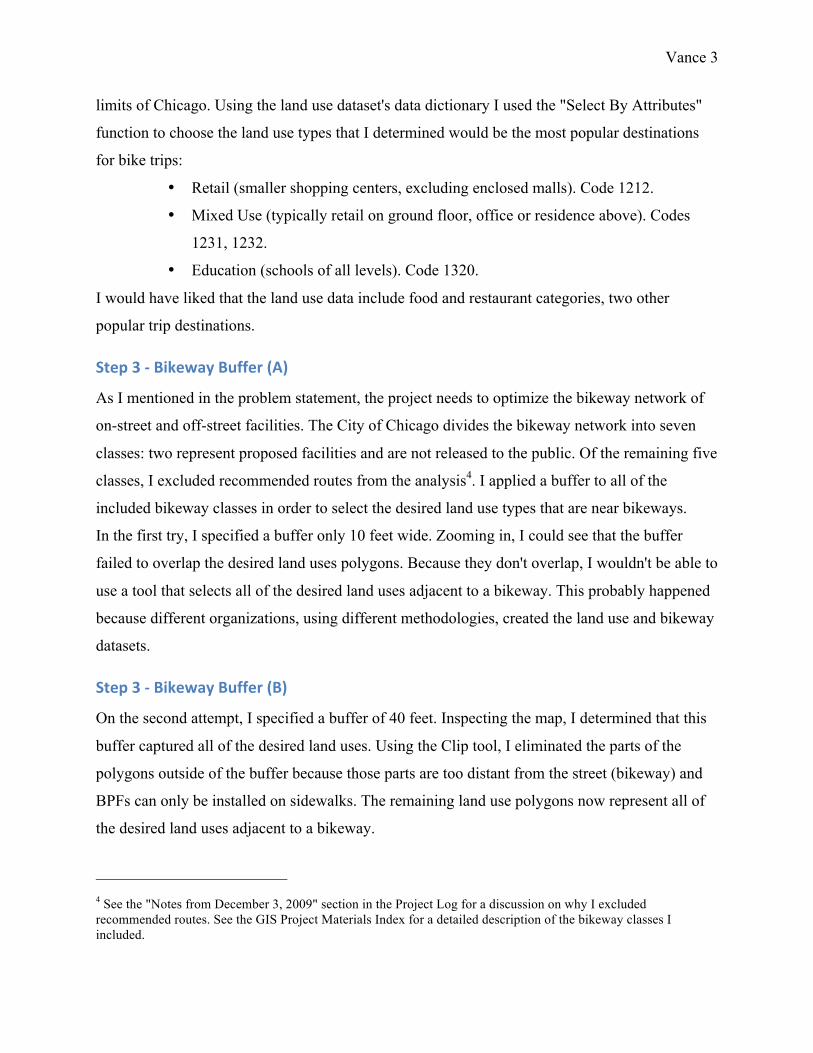
limits of Chicago. Using the land use dataset's data dictionary I used the "Select By Attributes"
function to choose the land use types that I determined would be the most popular destinations
for bike trips:
• Retail (smaller shopping centers, excluding enclosed malls). Code 1212.
• Mixed Use (typically retail on ground floor, office or residence above). Codes
1231, 1232.
• Education (schools of all levels). Code 1320.
I would have liked that the land use data include food and restaurant categories, two other
popular trip destinations.
Step 3 ‐ Bikeway Buffer (A)
As I mentioned in the problem statement, the project needs to optimize the bikeway network of
on-street and off-street facilities. The City of Chicago divides the bikeway network into seven
classes: two represent proposed facilities and are not released to the public. Of the remaining five
classes, I excluded recommended routes from the analysis4. I applied a buffer to all of the
included bikeway classes in order to select the desired land use types that are near bikeways.
In the first try, I specified a buffer only 10 feet wide. Zooming in, I could see that the buffer
failed to overlap the desired land uses polygons. Because they don't overlap, I wouldn't be able to
use a tool that selects all of the desired land uses adjacent to a bikeway. This probably happened
because different organizations, using different methodologies, created the land use and bikeway
datasets.
Step 3 ‐ Bikeway Buffer (B)
On the second attempt, I specified a buffer of 40 feet. Inspecting the map, I determined that this
buffer captured all of the desired land uses. Using the Clip tool, I eliminated the parts of the
polygons outside of the buffer because those parts are too distant from the street (bikeway) and
BPFs can only be installed on sidewalks. The remaining land use polygons now represent all of
the desired land uses adjacent to a bikeway.
4 See the "Notes from December 3, 2009" section in the Project Log for a discussion on why I excluded recommended routes. See the GIS Project Materials Index for a detailed description of the bikeway classes I included.

Vance 4
Step 4 ‐ Existing Bike Parking Facilities
Now I want to find all of the desired land uses that are not in a convenient distance to an existing
BPF. I determined this distance to be 50 feet5. Use the Select By Location tool to select all land
uses within 50 feet of a BPF. In the Attribute Table, invert (or switch) the selection so that now
all land uses not within 50 feet of a BPF are selected. These land use polygons far away from
existing BPF are the places I should survey to see if I can install a new bike rack. These are the
locations I want in the output table.
With these locations, calculate the coordinates of the centroid in the Attribute Table using the
Calculate Geometry function so there’s some semblance of a geographic location. I call these
data "potentials," as in potential new locations for bike parking facilities.
Desired Outcome
The table of potentials looks like this: A feature ID, their respective land use types, and their
geographic coordinates. Geographic coordinates are not helpful to the staff member who had to
perform the on-site survey. Street addresses are more useful. I could use a GPS device, but I
don’t have that equipment and addresses are easier to comprehend and locate. The solution is to
use reverse geocoding. See the table "Before RG" in the Output Table file.
Finding Addresses
A website called BatchGeocode.com will perform reverse geocoding: it accepts geographic
coordinates and returns to the user approximated street addresses. It hooks into a system offered
by Google’s Maps division. The process will turn the table of coordinates into a table of street
addresses. This table is described in the GIS Project Materials Index. See the table "After RG"
in the Output Table file.
Limitations
The GIS project as I just described isn’t without limitations.
• Because the provided land use data lacks street addresses, I had to reverse geocode. This
introduces another level of data inaccuracy and returns only approximations.
5 I don't have research that supports using this distance. In the Bicycle Parking Program at the City of Chicago, it is our policy to avoid installing bike parking facilities further than this from the destination. Anecdotally, we've often witnessed bicyclists lock their bicycles to inferior objects in what we see as a demonstration of the desire for convenience.

Vance 5
• The online reverse geocoder has a limit of how many requests can be made by all users in
a single day.
• The reverse geocoding process, like forward geocoding, gives only an approximation
based on the data available. See three examples of these approximations in the Output
Table file (attached).
• The centroid calculation technique I used to determine the land use polygons’ addresses
(by reverse geocoding) only tells me about the center of the polygon and may even exist
outside the polygon depending on its shape. This can be overcome by using the Feature to
Point tool (and specifying the point to be inside the polygon) instead of using Calculate
Geometry. It will also be overcome with a staff member's on-site survey who will find
the best location at the site.
Conclusion
This project shows how geographic information systems can be used to develop a process for
selecting potential good locations for new bike parking facilities. This process should be
considered another way a bike parking program can use to find locations for bike parking. It can
be used in concert with existing and other methods to find locations for bike parking.
Additionally, I have mentioned several ways how the process I developed for the project can be
expanded and enhanced. This process is especially helpful because it outputs a table that shows
the locations that meet my program's criteria for installing BPFs: good locations near bikeways
and away from existing BPFs.
It’s time to survey!
Credits: I would like to thank Nina and Diego for imagining the concept and helping me design
the workflow.
Appendix A ‐ List of tools and functions used
Tools (T) and functions (F) in ArcGIS ArcMap.
• Project T • Select By Attributes F • Buffer T • Clip T • Select By Location F • Switch Selection F • Calculate Geometry F • Export as DBF F

Vance 6
GIS Project Materials Index
This document lists and describes the materials in the project entitled “Finding potential new
bike parking locations.” The index is divided into the Maps, Tables, and Data Sources sections.
Maps
Maps are available visually in ArcMap-native MXD, as well as PDF and PNG formats. The
maps’ filenames are prefixed with “map01.”
Map F is the most descriptive map and the only map included in the printed report. You should
inspect this map first. The remaining maps show the procession of the tasks performed to obtain
the final map and output table.
A
This map is not included. This map document includes all of the data necessary to produced the
data in the succeeding maps as well as the output tables. It is only available as MXD.
B
This map shows the City of Chicago and all land use polygons of the four desired types:
• 1212 – Retail Centers • 1231 – Urban Mix with dedicated parking • 1232 – Urban Mix without dedicated parking • 1320 – Education Facilities
Each type is symbolized.
C
This map shows the City of Chicago, major roads, and selected bikeway classes:
• 1 – On-street bike lane – Indicated on the road pavement with a left and right stripe, containing a bicycle symbol and arrow indicating the direction of traffic.
• 2 – Marked shared lane – Indicated on the road pavement with a right stripe, with a bicycle symbol and two chevron symbols several feet to the left.
• 5 – Off-street trail. The Lakefront Trail falls under this category. These facilities are also known as multi-use paths or trails.
• 7 – Access path (these are short off-street routes that lead bicyclists to off-street trails are most often found leading to the Lakefront Trail via under or overpasses).
Each type is symbolized. Class 4 is available in the shapefile data but was excluded for this
analysis. Skipped values, 3 and 6, indicate proposed routes and are protected information.
Only selected Class 1 and 5 bikeways are labeled. Roads are not labeled.

Vance 7
D
This map shows the clipped desired land use types in the City of Chicago. This map essentially
shows where maps B and C overlap.
This is the map that generated the resulting table of the desired land use types adjacent to
Bikeways (classes 1, 2, 5, and 7).
E
This map is similar to map D with the addition of Bikeways. Only selected Class 1 and 5
bikeways are labeled.
F (final map)
This map is similar to map E with the addition of major roads. Only selected Class 1 and 5
bikeways are labeled. Roads are not labeled.
Tables
The three tables described below are found in the file, “Output Table."
"Potential Locations"
Also called "Complete address list after reverse geocoding function."
This worksheet shows the complete table of street addresses representing desired land use types
near bikeways in the City of Chicago. The most reliable piece of information is the geographic
coordinates because the street addresses are estimates.6 This data is represented by Maps D, E,
and F. The printed report only includes the first of 18 pages.
Before RG”
Also called "Sample address list before reverse geocoding function."
This worksheet has a sample list with locations identical to those in the “After Reverse
Geocoding” worksheet but without the information obtained from the reverse geocoding
function.
"After RG”
Also called "Sample address list after reverse geocoding function."
6 The reverse geocoding function is run through the BatchGeocode.com website using the Google Maps API.

Vance 8
This worksheet has a sample list of street addresses obtained through the reverse geocoding
function. The function has multiple output limitations. Three are identified and noted in the
Remarks column.
Data Sources
I used data from only two sources.
City of Chicago
Data procured from the City of Chicago website, <http://www.cityofchicago.org>. Look under
Departments, find the Department of Innovation and Technology. From there, select GIS Team
and then look under the Data section.
• Bikeways network (shapefile) • City boundary (shapefile) - This dataset was used to clip the CMAP Land Use data. • Roads (shapefile) - This dataset was used only for map display purposes and comes from
the larger Transportation dataset. • Existing bike parking facilities (Excel) - I had access to the complete, unfiltered database,
but now the data is publicly available in a machine-readable format at <http://www.chicagobikes.org/bikeparking>.
The first three shapefiles are all conveniently projected with NAD1983 Illinois StatePlane Feet
East. The bike parking facilities information contained geographic coordinates using the
WGS1984 geographic coordinate system and was projected to NAD1983 Illinois StatePlane Feet
East using ArcGIS's built in transformation between the two coordinate systems.
Chicago Metropolitan Agency for Planning
Land use data came from Chicago Metropolitan Agency for Planning’s 2001 land use inventory,
available on the Blackboard for the class, UPP 508. The shapefile is conveniently projected with
NAD1983 Illinois StatePlane Feet East.
These pages follow:
• Map F • Output Tables
o Potential Locations - "Complete address list after reverse geocoding function" - Only the first of 18 pages is included.
o Before Reverse Geocoding - "Sample address list before reverse geocoding function"
o After Reverse Geocoding - "Sample address list before reverse geocoding function"
• Project Log

N ELSTON AVE
S LAKEFRONT TRAIL
N LAKEFRONT TRAIL
N HA
LSTE
D ST
W MARQUETTE RD S SOUTH CHICAGO AVE
W ROOSEVELT RD
N DA
MEN
AVE
MAJOR TAYLOR TRAIL
W WASHINGTON BLVDW WARREN BLVD
W LAWRENCE AVE
E MARQUETTE RD
S HA
LSTE
D ST
W PRATT BLVD
S DREXEL BLVD
S DA
MEN
AVE
N DA
MEN
AVE
Desired Land Use Types near Bikeways in ChicagoLegend
BikewaysMajor Roads
Desired Land Use Types near Bikeways1212 - Retail Centers1231 - Mixed use, with parking1232 - Mixed use, without parking1320 - Education Facilities
0 3 61.5 Miles¯
Only selected on-street bikelanes and off-street trails arelabeled. Only selected roadsare displayed.Map prepared by Steven Vanceon December 3, 2009, usingBikeways, Roads, andBoundary data from the City ofChicago and Land Use datafrom CMAP 2001 Land UseSurvey. Map is projected inNAD1983 Illinois StatePlaneFeet East.
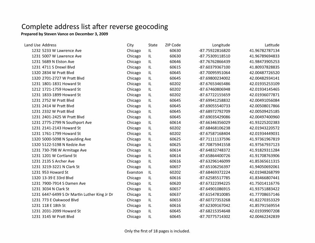
Only the first of 18 pages is included.
Complete address list a:er reverse geocodingPrepared by Steven Vance on December 3, 2009
Land Use Address City State ZIP Code Longitude LaCtude1232 5233 W Lawrence Ave Chicago IL 60630 ‐87.75922816820 41.967827871341231 5007 W Lawrence Ave Chicago IL 60630 ‐87.75309118510 41.967896948331231 5689 N Elston Ave Chicago IL 60646 ‐87.76762866439 41.984739052531231 4711 S Drexel Blvd Chicago IL 60615 ‐87.60379367100 41.809378288351320 2834 W PraT Blvd Chicago IL 60645 ‐87.70095951064 42.004877265201320 2701‐2727 W PraT Blvd Chicago IL 60645 ‐87.69800234002 42.004829341411231 1801‐1831 Howard St Chicago IL 60202 ‐87.67653465486 42.019352531091212 1721‐1759 Howard St Chicago IL 60202 ‐87.67460806948 42.019341454651231 1833‐1899 Howard St Chicago IL 60202 ‐87.67722155659 42.019360778711231 2752 W PraT Blvd Chicago IL 60645 ‐87.69941258832 42.004910560841231 2414 W PraT Blvd Chicago IL 60645 ‐87.69055540733 42.005080178661231 2332 W PraT Blvd Chicago IL 60645 ‐87.68972792709 42.005094251851231 2401‐2425 W PraT Blvd Chicago IL 60645 ‐87.69035429086 42.004974009601231 2775‐2799 N Southport Ave Chicago IL 60614 ‐87.66346356029 41.932252023831231 2141‐2143 Howard St Chicago IL 60202 ‐87.68468106238 42.019432205721231 1761‐1799 Howard St Chicago IL 60202 ‐87.67587168404 42.019344490311320 5000‐5098 N Spaulding Ave Chicago IL 60625 ‐87.71111137596 41.973619678191320 5122‐5198 N Kedzie Ave Chicago IL 60625 ‐87.70875941558 41.975679371231231 730‐798 W Armitage Ave Chicago IL 60614 ‐87.64832748372 41.918293112841231 1201 W Cortland St Chicago IL 60614 ‐87.65864400726 41.917087639061231 2135 S Archer Ave Chicago IL 60616 ‐87.63296146099 41.853656113151231 3219‐3221 N Clark St Chicago IL 60657 ‐87.65106256397 41.940506920611231 953 Howard St Evanston IL 60202 ‐87.68469372224 42.019482687991320 13‐39 E 33rd Blvd Chicago IL 60616 ‐87.62585517785 41.834668074411231 7900‐7914 S Damen Ave Chicago IL 60620 ‐87.67322394225 41.750141167761231 3034 N Clark St Chicago IL 60657 ‐87.64901086915 41.937518834221231 6447‐6499 S Dr MarCn Luther King Jr Dr Chicago IL 60637 ‐87.61547810085 41.777086571461231 773 E Oakwood Blvd Chicago IL 60653 ‐87.60727353268 41.822703533291231 118 E 18th St Chicago IL 60616 ‐87.62309167042 41.857915695541231 2031‐2099 Howard St Chicago IL 60645 ‐87.68215354648 42.019399072081231 3145 W PraT Blvd Chicago IL 60645 ‐87.70775714302 42.00462242839

Sample address list before reverse geocoding func5on
ID Land Use Longitude La5tude0 1232 ‐87.75922816820 41.967827871341 1231 ‐87.75309118510 41.967896948332 1231 ‐87.76762866439 41.984739052533 1231 ‐87.60379367100 41.809378288354 1320 ‐87.70095951064 42.004877265205 1320 ‐87.69800234002 42.004829341416 1231 ‐87.67653465486 42.019352531097 1212 ‐87.67460806948 42.019341454658 1231 ‐87.67722155659 42.019360778719 1231 ‐87.69941258832 42.0049105608410 1231 ‐87.69055540733 42.0050801786611 1231 ‐87.68972792709 42.0050942518512 1231 ‐87.69035429086 42.0049740096013 1231 ‐87.66346356029 41.9322520238314 1231 ‐87.68468106238 42.0194322057215 1231 ‐87.67587168404 42.0193444903116 1320 ‐87.71111137596 41.9736196781917 1320 ‐87.70875941558 41.9756793712318 1231 ‐87.64832748372 41.9182931128419 1231 ‐87.65864400726 41.9170876390620 1231 ‐87.63296146099 41.8536561131521 1231 ‐87.65106256397 41.9405069206122 1231 ‐87.68469372224 42.0194826879923 1320 ‐87.62585517785 41.8346680744124 1231 ‐87.67322394225 41.7501411677625 1231 ‐87.64901086915 41.9375188342226 1231 ‐87.61547810085 41.7770865714627 1232 ‐87.64224653212 41.67921611058
Prepared by Steven Vance on December 3, 2009.

Sample address list a-er reverse geocoding func5on
Land Use Address City State ZIP Code Longitude La5tude Remarks1232 5233 W Lawrence Ave Chicago IL 60630 ‐87.75922816820 41.967827871341231 5007 W Lawrence Ave Chicago IL 60630 ‐87.75309118510 41.967896948331231 5689 N Elston Ave Chicago IL 60646 ‐87.76762866439 41.984739052531231 4711 S Drexel Blvd Chicago IL 60615 ‐87.60379367100 41.809378288351320 2834 W PraT Blvd Chicago IL 60645 ‐87.70095951064 42.004877265201320 2701‐2727 W PraT Blvd Chicago IL 60645 ‐87.69800234002 42.00482934141 Reverse geocoding func5on returned a range of
street addresses. This may mean that no parcel at this coordinate was found and the func5on selected the street segment instead.
1231 1801‐1831 Howard St Chicago IL 60202 ‐87.67653465486 42.019352531091212 1721‐1759 Howard St Chicago IL 60202 ‐87.67460806948 42.019341454651231 1833‐1899 Howard St Chicago IL 60202 ‐87.67722155659 42.019360778711231 2752 W PraT Blvd Chicago IL 60645 ‐87.69941258832 42.004910560841231 2414 W PraT Blvd Chicago IL 60645 ‐87.69055540733 42.005080178661231 2332 W PraT Blvd Chicago IL 60645 ‐87.68972792709 42.005094251851231 2401‐2425 W PraT Blvd Chicago IL 60645 ‐87.69035429086 42.004974009601231 2775‐2799 N Southport Ave Chicago IL 60614 ‐87.66346356029 41.932252023831231 2141‐2143 Howard St Chicago IL 60202 ‐87.68468106238 42.019432205721231 1761‐1799 Howard St Chicago IL 60202 ‐87.67587168404 42.019344490311320 5000‐5098 N Spaulding Ave Chicago IL 60625 ‐87.71111137596 41.973619678191320 5122‐5198 N Kedzie Ave Chicago IL 60625 ‐87.70875941558 41.975679371231231 730‐798 W Armitage Ave Chicago IL 60614 ‐87.64832748372 41.918293112841231 1201 W Cortland St Chicago IL 60614 ‐87.65864400726 41.917087639061231 2135 S Archer Ave Chicago IL 60616 ‐87.63296146099 41.853656113151231 3219‐3221 N Clark St Chicago IL 60657 ‐87.65106256397 41.940506920611231 953 Howard St Evanston IL 60202 ‐87.68469372224 42.01948268799 This address is outside of Chicago and is a result of
the reverse geocoding func5on. The actual land use polygon is within Chicago.
1320 13‐39 E 33rd Blvd Chicago IL 60616 ‐87.62585517785 41.834668074411231 7900‐7914 S Damen Ave Chicago IL 60620 ‐87.67322394225 41.750141167761231 3034 N Clark St Chicago IL 60657 ‐87.64901086915 41.937518834221231 6447‐6499 S Dr Mar5n Luther King Jr Dr Chicago IL 60637 ‐87.61547810085 41.777086571461232 Major Taylor Trail Chicago IL 60643 ‐87.64224653212 41.67921611058 A street address was not found by the reverse
geocoding func5on.
Prepared by Steven Vance on December 3, 2009.

Vance 1
Can Haz:Users:stevevance:Documents:School:UPP 508 GIS:FinalProject_2:Final
120409:Project Log.docx
Procedures for Final Project (Project Log)
November 12, 2009
Steven Vance
Opened new, blank map at SEL2058 on ArcGIS 9.3, build 1770.
Problem: Find good locations (popular destinations) on the bikeway away from existing bike
parking facilities.
Two final products:
Projected Workflow
1. A GIS session is created with the following data: the Chicago bikeway network,
the locations of existing bike parking facilities and the number of bike racks and spaces at
each, and lastly a land use survey whose data is formatted using polygons.
2. The relevant land use types are identified and selected (using a Select By
Attributes function) so that all other land use types are no longer featured in the GIS
session. These relevant land use types will come from commercial and retail categories,
or whatever categories are identified as being the largest attractor of non-recreational
trips on bike
3. A buffer of 10 feet is added to the bike routes polylines. This is so that we can
find all of the attracting land use types (commercial, retail) and select them. The land use
data is then clipped using the bike route buffer to create a dataset that lists all preferential
land uses along bike routes.
4. Using the Select By Location function, the land use polygons that are within 50
feet of a bike parking facility are selected. Export this selection as a layer called
"landuse_with_bikeparking." Invert the selection by using the Switch Selection. Now,
only land use polygons that are not within 50 feet of a bike parking facility are selected.
Export this selection as a new layer called "landuse_without_bikeparking."
!"#"$%
• &'()*"+,-./0-12,342%!"#"%567),%8967%:!;<%='()%>96?9"72%<3',%@"#"%3",%&))A%
5B)"A)@%&+%:!;<%869%4C&B'5%56A,C74#'6A2%!"#"%5C99)A#%",%68%-.D/0DE--12%
o F6*,$%GHI%
o :6B,$%/H%
o <3)%<J>K%8')B@%3",%.%CA'LC)%M"BC),2%<3),)%"9)%&'()*"+%5B",,),2%<3)%5B",,),%
"9)$%! 1 on street bike lane
! 2 on street shared lane
! 4 recommended bike route
! 5 off street trail
! 7 access path
o The skipped or missing values indicate proposed routes and are protected
information.
• &'()9"5(,N&2OB,%
o F6*,$%.EE/%
o :6B,$%/-%
Vance 2
Can Haz:Users:stevevance:Documents:School:UPP 508 GIS:FinalProject_2:Final
120409:Project Log.docx
o P",%Q!%8')B@%#3"#%9)49),)A#,%#3)%F"5(Q!R%*3'53%9)49),)A#,%"%&'()%4"9('A?%
8"5'B'#+%'A,#"BB"#'6A%*'#3%6A)%69%769)%&'()%9"5(,2%
• &'()9"5(,N&2@&8%
o F6*,$%.EE/%
o :6B,$%//%
• &'()9"5(,2,34%69%2OB,2%!"#"%567),%8967%:!;<%='()%>96?9"72%Q%,#'BB%A))@%#6%?)#%#3',%
@"#"%8967%#3)%%
• B"A@C,)N53'5"?6N7+56@),2,34%
o F6*,$%.-GH%
o :6B$%G%
o <3',%,3"4)8'B)%9)49),)A#,%"BB%B"A@%C,)%46B+?6A,%'A%:3'5"?6%#3"#%7"#53)@%#3)%
B"A@%C,)%56@),%Q%*"A#)@$%/E/ER%/EI/R%/EIER%"A@%/IE-2%S))%&)B6*%869%#3)'9%
A"7),2%S))%TU-/N,53)7)2@65%869%#3)'9%@)8'A'#'6A,2%
• B"A@C,)N53'5"?62,34%
o F6*,$%/HV-1%
o :6B,$%GR%*",%1%
o =)5"C,)%#3',%,3"4)8'B)%',%?)A)9"#)@%M'"%5B'4%8967%B"A@C,)2,34R%#3)%S3"4)NT)A?%
"A@%S3"4)NW9)"%8')B@,%"9)%76,#%B'()B+%M)9+%'A"55C9"#)2%F)76M)%#3),)%8')B@,2%
:"A%"@@%B"#)9%"A@%9)@6%?)67)#9+2%
• B"A@C,)2,34%
o F6*,$%1GGHH%
o :6B,$%1%
o P",%S3"4)NT)A?%"A@%S3"4)NW9)"%8')B@,2%XC,#%9)5"B5CB"#)%#3),)2%
Y)9,'6A%E2/%68%#3)%E--/%T"A@%U,)%QAM)A#69+%'A%W95ZQS%,3"4)8'B)%8697"#2%QA5BC@),%
#3)%86BB6*'A?%!=[%#"&B),%#6%,)9M)%",%B66(C4%#"&B),$%
T"A@C,)!67"'AT',#2@&8$%T66(C4%#"&B)%869%TW\!USK%8')B@%
T"A@C,)E!67"'AT',#2@&8$%T66(C4%#"&B)%869%TW\!USKE%8')B@%
;4)AS4"5)!67"'AT',#2@&8$%T66(C4%#"&B)%869%;SN;]\:;!K%8')B@%
% S))%6#3)9%8'B),%'A%#3)%^B"A@C,)^%86B@)9R%'A5BC@'A?%9)"@7)2@65R%TU-/N,53)7)2@652%
<",(,%
• //^/I^E--1%G$//%>X%
• QA%X+S_T%"@7'A',#9"#'6AR%?"#3)9%@"#"%869%&'()9"5(,2OB,2%%
o U,)%LC)9+$%SKTK:<%'@R%`B"#`R%`B6A?`R%#+4)NWIR%#+4)NW.R%#+4)N=R%#+4)N4B"a"R%
#+4)N4B"a"X'A'R%#+4)N4B"a"P"B8R%#+4)N*"BB%[F;X%`9"5(N96C#)4B"A`%]PKFK%
@"#)N'A,#"BB)@%b%-%;F%3',#69'5"B%c%/%
o <3)A%5B'5(%KO469#%"#%#3)%&6##67%68%#3)%4"?)2%S)B)5#%X'596,68#%KO5)B%E---R%
53)5(%d>C#%8')B@%A"7),%'A%8'9,#%96*2e%
o S"M)%8'B)%",%&'()9"5(,N"2OB,%%
o ;4)A%8'B)2%:6AM)9#%"BB%dAC7&)9,%,#69)@%",%#)O#e%#6%AC7&)9,2%
o S"M)%8'B)%",%&'()9"5(,N&2OB,R%5366,'A?%X'596,68#%KO5)B%E--I%8697"#%f869%,67)%
9)",6A%KO5)B%#36C?3#%#3',%*",%"%])&%4"?)^P<XT%@65C7)A#g2%
o :B6,)%KO5)B2%
• ;4)A%W95X"4%*'#3%"%A)*R%&B"A(%7"42%
• W@@%&'()9"5(,N&2OB,%#6%<"&B)%68%:6A#)A#,%f<;:g%
o ;4)A%#3',%#"&B)%"A@%M)9'8+%'#%3",%#3)%5699)5#%AC7&)9%68%96*,2%
o KO469#%",%!=[%8'B)2%\"7)%'#%&'()9"5(,N&2@&8%

Vance 3
Can Haz:Users:stevevance:Documents:School:UPP 508 GIS:FinalProject_2:Final
120409:Project Log.docx
o F'?3#D5B'5(%#3)%&'()9"5(,N&%'A%<;:%"A@%5B'5(%d!',4B"+%hJ%!"#"2e%<3)%8CA5#'6A%
*'BB%"C#67"#'5"BB+%,)B)5#%#3)%5699)5#%8')B@,R%&C#%iC,#%'A%5",)R%869%7)%'#%,)B)5#)@%
B6A?%",%hR%B"#%",%J2%
o S)B)5#%"%49)@)8'A)@%5669@'A"#)%,+,#)7$%Z:S%]ZS%/1V02%f<3',%*6CB@%&)%#3)%
,"7)%",%!)8'A)%>96i)5#'6A%#66B2g%
o &'()9"5(,N&%KM)A#,%B"+)9%*",%59)"#)@%
o \6*R%*)%A))@%#6%496i)5#%'#%6A#6%6C9%,6C95)%@"#"R%*3'53%*'BB%&)%S#"#)>B"A)%
QBB'A6',%[Q>S%K",#%f[))#g%\W!%/1VI2%
• ;4)A%W95<66B&6O%"A@%,)B)5#%#3)%>96i)5#%#66B2%%
o QA4C#$%%% % % &'()9"5(,N&%KM)A#,%
o ;C#4C#$%% % % &'()9"5(,N5%
o ;C#4C#%:669@'A"#)%S+,#)7$
% \W!N/1VINS#"#)>B"A)NQBB'A6',NK",#N[Q>SN/E-/N[))#%
o :6AM)9,'6A%X)#36@$% % \W!N/1VIN#6N]ZSN/1V0N/%
o :B'5(%6("+2%
o ]WF\Q\Z%---HIE$%!"#C7%56A8B'5#%&)#*))A%7"4%"A@%6C#4C#2%
• //^/I^E--1%G$I/%>X%
• S'A5)%#3)%!"#"%[9"7)%"@64#)@%#3)%Z:S%68%#3)%&'()9"5(,N&2@8&%8'B)R%#3)A%#3)%M')*%*'BB%
&)%'A"55C9"#)2%
o :B6,)%W95X"4%j%@6Ak#%,"M)2%
o ;4)A%W95X"4%*'#3%"%A)*R%&B"A(%7"42%
o W@@%!"#"$%&'()9"5(,N52,34R%5'#+&6CA@"9+2,34R%#9"A,469#"#'6A2,34R%B"A@C,)2,34%
o \6*%#3)%M')*%',%"55C9"#)l%
• S"M)%7"4%",%7"4-/"27O@%
• \;<K$%Q#%"44)"9,%#3"#%[Q!%IEIH%f'@%0.HHg%',%,36*'A?%6C#,'@)%#3)%5'#+%B'7'#,2%Qk7%
?6'A?%#6%'?A69)%#3',%869%A6*2%Q#%496&"&B+%3",%"A%'A"55C9"#)%hJ%5669@'A"#)2%
• //^/I^E--1%G$0G%>X%
• KO469#)@%7"4%",%',2%S"M)@%",%7"4-/"N-/24A?%
• Q%3"M)%769)%B"A@%C,)%@"#"%#3"A%Q%A))@%j%'#%,))7,%#6%,36*%B"A@%C,)%@"#"%869%,'O%
56CA#'),2%Qk7%?6'A?%#6%5B'4%688%#3)%"9)",%6C#,'@)%68%:3'5"?62%
o QA4C#$% % B"A@C,)%
o :B'4%[)"#C9)$% %5'#+&6CA@"9+%
o ;C#4C#$% % B"A@C,)N53'5"?6%
o :B'5(%6("+2%
• Q#%,))7,%#3"#%Q%3"M)%"BB%#3)%@"#"%Q%A))@%6A%#3',%7"42%\6*%Q%A))@%#6%'@)A#'8+%#3)%
"449649'"#)%B"A@%C,)%56@),2%Q%3"M)%#3)%@"#"%@'5#'6A"9+%869%#3)%B"A@%C,)%56@),%*3'53%
5"7)%*'#3%#3)%B"A@C,)%,3"4)8'B)2%Q%*"A#%#6%8'A@%56@),%#3"#%9)49),)A#%5677)95'"BR%
9)#"'BR%"A@%,5366B,2%;4)A%8'B)%TU-/N,53)7)2@652%
• Q%*"A#%#3)%86BB6*'A?%56@),$%
o /E/E%j%F)#"'B%:)A#)9,2%Q%'A#)949)#%#3',%",%,#9'4%7"BBR%68%*3'53%:3'5"?6%3",%"%B6#%
682%W%m)*)B%69%!67'A'5(k,%?965)9+%,#69)%',%6M)9%I-R---%,LC"9)%8))#%"A@%"B6A?%
*'#3%"%S#"4B),%69%n7"9#R%#3)%/--R---%,LC"9)%8))#%#39),36B@%#6%&)%'A5BC@)@%'A%
#3',%5"#)?69+%',%)",'B+%9)"53)@2%UA869#CA"#)B+R%#36C?3R%#3),)%,#9'4%7"BB,%"9)%
M)9+%&'()%CA89')A@B+%&)5"C,)%#3)+%"9)%C,C"BB+%8"9%&"5(%8967%#3)%,#9))#%,6%"%
&'5+5B',#%7C,#%9'@)%#396C?3%"%4"9('A?%B6#%#3"#%)A@"A?)9,%&'5+5B',#,2%F'?3#%A6*R%
#3)%:'#+%68%:3'5"?6%5"AA6#%'A,#"BB%6A%49'M"#)%4964)9#+%"A@%,'A5)%#3)%@',#"A5)%
Vance 4
Can Haz:Users:stevevance:Documents:School:UPP 508 GIS:FinalProject_2:Final
120409:Project Log.docx
&)#*))A%#3)%,#9))#^,'@)*"B(%f*3)9)%#3)%:'#+%6*A,%#3)%9'?3#%68%*"+%4964)9#+g%
',%#66%?9)"#R%*)%"&,#"'A%8967%'A,#"BB'A?%&'()%9"5(,%3)9)2%
o /EI/%j%U9&"A%X'O%*'#3%@)@'5"#)@%4"9('A?%
o /EIE%j%U9&"A%X'O%*'#36C#%@)@'5"#)@%4"9('A?%
o /IE-%j%K@C5"#'6A%["5'B'#'),%
• S)B)5#%#3),)%9)569@,%C,'A?%S)B)5#%=+%W##9'&C#),2%U,)%#3',%LC)9+$%oTW\!USKo%c%p/E/Ep%
;F%oTW\!USKo%c%p/EI/p%;F%oTW\!USKo%c%p/EIEp%;F%oTW\!USKo%c%p/IE-p%
• KO469#%#3',%,)B)5#'6A%",%"%A)*%,3"4)8'B)%5"BB)@%B"A@C,)N53'5"?6N7+56@),2,34%
f7+56@),g%"A@%"@@%#3',%@"#"%#6%#3)%7"42%
• <C9A%688%"BB%B"+)9,%)O5)4#%869%7+56@),%R%&'()*"+,R%"A@%5'#+&6CA@"9+%#6%,))%*3)9)%
#3),)%B"A@%C,)%46B+?6A,%B')2%Q%A6#'5)@%#3)+%86BB6*%#3)%,#9))#%?9'@2%Q%)O4)5#)@%#3',2%
<3)+%@6Ak#%86BB6*%iC,#%"A+%,#9))#R%#36C?3R%#3)+%86BB6*%#3)%"9#)9'"B,%f/%7'B)g%"A@%
,)56A@"9+%"9#)9'"B,%f3"B8%7'B)g2%%
• <3)9)%"9)%.%5B",,),%68%&'()*"+,%f,))%B',#'A?%"&6M)%'A%@"#"%@'5#'6A"9+g2%
o [69%#3)%8'9,#%&C88)9R%Qk7%?6'A?%#6%)O5BC@)%9)5677)A@)@%96C#),%"A@%6AB+%
'A5BC@)%6AD,#9))#%69%688D,#9))#%8"5'B'#'),2%QA%>964)9#'),b!)8'A'#'6A%_C)9+R%
'A,)9#%o<J>Ko%qb%p0p%
o [69%,)56A@%&C88)9R%Q%,36CB@%,)B)5#%@'88)9)A#%5B",,),2%U>!W<K$%Q%A)M)9%59)"#)@%"%
,)56A@%&C88)9%#3"#%C,)@%"%@'88)9)A#%&'()*"+%5B",,R%&C#%Q%@'@%59)"#)%#*6%&C88)9,%
f6A)%/-%8))#%*'@)R%&C#%9)4B"5)@%*'#3%6A)%0-%8))#%*'@)g2%
• //^/I^E--1%V$EE%>X%
• :9)"#)%8'9,#%&C88)92%
o QA4C#$% % &'()*"+,%
o ;C#4C#$% % &'()*"+,N&C88)9N)O5BC@)02,34%
o !',#"A5)$% T'A)"9%UA'#$%/-%8))#2%
o S'#)%<+4)$% [CBB%
o KA@%<+4)$%% F6CA@%f#3',%',%@)8"CB#%64#'6A2%Qk7%5366,'A?%#3',%&)5"C,)%
W95Y')*R%W95K@'#69%@6Ak#%3"M)%[B"#%5"4"&'B'#+g%
o !',,6BM)%<+4)$% WBB%fQ%A))@%"BB%68%#3)%&C88)9,%'A%"%,'A?B)%,3"4)%,6%'#k,%
)",')9%869%7)%#6%,)B)5#%#3)%&'()%9"5(%8)"#C9),%*'#3'A%#3)%&C88)9g2%
o \6%!',,6BM)%[')B@,2%Q8%Q%(A)*%769)%"&6C#%*3"#%Q%*",%@6'A?R%'#%,))7,%B'()%#3',%
*6CB@%&)%"%4B"5)%#3"#%*6CB@%,"M)%7)%#'7)%6M)9%59)"#'A?%7CB#'4B)%&C88)9,%
&)5"C,)%#3',%*6CB@%59)"#)%7CB#'4B)%&C88)9,%f/%4)9%&'()*"+%5B",,g%'A%#3)%,"7)%
)O)5C#'6A%68%#3',%#66B2%
o :B'5(%6("+2%
o KO)5C#'A?$%=C88)9%&'()*"+,%
K$rU>>.-VNZQSr['A"B>96i)5#NEr@"#"r&'()*"+,N&C88)9N)O5BC@)02,34%o/-%
[))#o%[UTT%F;U\!%WTT%s%
S#"9#%<'7)$%[9'%\6M%/I%E-$E0$E.%E--1%
KO)5C#)@%f=C88)9g%,C55),,8CBB+2%
KA@%<'7)$%[9'%\6M%/I%E-$E0$IG%E--1%fKB"4,)@%<'7)$%/E2--%,)56A@,g%
o <66(%,59))A,36#$%7"4-/"N-E24A?%
• =C88)9%',%59)"#)@2%Q%a667%'A%"96CA@%UQ:%"#%P"B,#)@%"A@%<"+B69%"A@%Q%8'A@%#3"#%#3)%/-%
866#%&C88)9%',%A6#%)A6C?32%Q%*'BB%@)B)#)%#3',%,3"4)8'B)%"A@%#9+%"?"'AR%&C#%*'#3%0-%8))#2%
o S"7)%4"9"7)#)9,%",%"&6M)R%&C#%A6*%0-%8))#2%

Vance 5
Can Haz:Users:stevevance:Documents:School:UPP 508 GIS:FinalProject_2:Final
120409:Project Log.docx
o KO)5C#'A?$%=C88)9%&'()*"+,%
K$rU>>.-VNZQSr['A"B>96i)5#NEr@"#"r!"#$%&'()!*++$,)$-./*0$1)!2(345o0-%
[))#o%[UTT%F;U\!%WTT%s%
S#"9#%<'7)$%[9'%\6M%/I%E-$EH$.1%E--1%
KO)5C#)@%f=C88)9g%,C55),,8CBB+2%
KA@%<'7)$%[9'%\6M%/I%E-$EG$-G%E--1%fKB"4,)@%<'7)$%V2--%,)56A@,g%
• <3)%0-%866#%&C88)9%',%?9)"#2%Q#%A6*%6M)9B"4,%#3)%B"A@%C,)%46B+?6A,%"#%UQ:%"#%P"B,#)@%
"A@%<"+B692%\;<Q:K$%<3)%A)*%A"7)%68%#3)%&C88)9%,3"4)8'B)%"&6M)%'A%&6B@2%
• \6*%Q%*"A#%#6%5B'4%"BB%68%#3)%B"A@%C,)%46B+?6A,%#3"#%"9)%'A,'@)%#3)%&C88)92%<3',%7)"A,%
#3"#%"BB%B"A@%C,)%46B+?6A,%6C#,'@)%#3)%&C88)9%*'BB%@',"44)"9%f&C#%,#'BB%&)%'A%#3)%
69'?'A"B%B"+)9g2%
o QA4C#%%[)"#C9),$%% B"A@C,)N53'5"?6N7+56@),%
o :B'4%[)"#C9),$%% &'()*"+,N&C88)9N)O5BC@)0N&%
o ;C#4C#$% % % B"A@C,)N'A,'@)N&C88)9N)O5BC@)0N&2,34%
o :B'5(%6("+2%
o KO)5C#'A?$%:B'4%B"A@C,)N53'5"?6N7+56@),%&'()*"+,N&C88)9N)O5BC@)0N&%
K$rU>>.-VNZQSr['A"B>96i)5#NEr@"#"rB"A@C,)N'A,'@)N&C88)9N)O5BC@)0N&2,34%s%
S#"9#%<'7)$%[9'%\6M%/I%E-$II$E-%E--1%
F)"@'A?%[)"#C9),222%
:9"5('A?%[)"#C9),222%
W,,)7&B'A?%[)"#C9),222%
KO)5C#)@%f:B'4g%,C55),,8CBB+2%
KA@%<'7)$%[9'%\6M%/I%E-$II$I/%E--1%fKB"4,)@%<'7)$%//2--%,)56A@,g%
o <66(%,59))A,36#$%7"4-/"N-I24A?%
• \6*%3'@)%#3)%B"+)9R%B"A@C,)N53'5"?6N7+56@),2%
• QA%#3)%A)*%B"A@C,)%B"+)9R%#3)9)%"9)%//EE%9)569@,2%<3"#%7)"A,%#3)9)%"9)%//EE%B"A@%
C,)%46B+?6A,%#3"#%"9)%68%#3)%86C9%@),'9)@%56@),%"A@%*'#3'A%0-%8))#%68%"%&'()*"+%
f)O5BC@'A?%9)5677)A@)@%96C#),g2%:674"9)%#3"#%AC7&)9%#6%#3)%69'?'A"B%.-GH%
9)569@,%68%#3)%86C9%@),'9)@%56@),2%
• !',4B"+%#3)%&'()9"5(,%B"+)92%
• \6*R%S)B)5#%=+%T65"#'6A%fS=TgR%8)"#C9),%8967%B"A@C,)N'A,'@)N&C88)9N)O5BC@)0N&%#3"#%
"9)%*'#3'A%"%@',#"A5)%68%#3)%8)"#C9),%'A%#3)%&'()9"5(,N5%B"+)92%:3)5(%688%d"44B+%&C88)9e%
"A@%'A4C#%.-%8))#2%
o :B'5(%W44B+2%
o ;4)A%#3)%"##9'&C#)%#"&B)%869%B"A@C,)N'A,'@)N&C88)9N)O5BC@)0N&%
o 0V0%9)569@,%,)B)5#)@R%*'#3'A%.-%8))#%68%&'()%4"9('A?%8"5'B'#+2%<3',%7)"A,%#3"#%
#3)9)%"9)%HIV%B"A@%C,)%46B+?6A,%f68%#3)%@),'9)@%56@),g%#3"#%"9)%\;<%*'#3'A%
.-%8))#%68%"%&'()%4"9('A?%8"5'B'#+R%"A@%56CB@%496&"&B+%C,)%6A)2%
o ]'#3%S=T%,#'BB%64)AR%53"A?)%.-%#6%/--%"A@%5B'5(%W44B+2%;4)A%#3)%"##9'&C#)%
#"&B)2%
o H-0%9)569@,%,)B)5#)@R%*'#3'A%/--%8))#%68%&'()%4"9('A?%8"5'B'#+2%<3',%7)"A,%#3"#%
#3)9)%"9)%./V%B"A@%C,)%46B+?6A,%f68%#3)%@),'9)@%56@),g%#3"#%"9)%\;<%*'#3'A%
.-%8))#%68%"%&'()%4"9('A?%8"5'B'#+R%"A@%56CB@%496&"&B+%C,)%6A)2%
o Qk7%?6'A?%&"5(%#6%.-%8))#%&)5"C,)%Q%*"A#%769)%B65"#'6A,%#6%,C9M)+%869%
46#)A#'"B%'A,#"BB"#'6A%68%"%&'()%4"9('A?%8"5'B'#+%f*'#3%6A)%69%769)%&'()%9"5(,g2%
<3',%',%'A%5",)%Q%3"M)%#6%9)i)5#%"%,'?A'8'5"A#%469#'6A%68%#3)%B65"#'6A,2%
Vance 6
Can Haz:Users:stevevance:Documents:School:UPP 508 GIS:FinalProject_2:Final
120409:Project Log.docx
• //^/I^E--1%V$00%>X%
• W8#)9%53"A?'A?%#3)%&C88)9%&"5(%#6%.-%8))#R%64)A%#3)%"##9'&C#)%#"&B)%"A@%5B'5(%
;4#'6A,bS*'#53%S)B)5#'6A2%<3',%A)*%,)B)5#'6A%68%HIV%9)569@,%"9)%#3)%B65"#'6A,%#6%
,C9M)+%869%46#)A#'"B%'A,#"BB"#'6A%68%"%&'()%4"9('A?%8"5'B'#+2%
• KO469#%#3',%,)B)5#'6A%",%46#)A#'"BNHIV2,34%
o !)B)#)%8')B@,$%]W<N\WXKR%;SN;]\:;!K%
• t667%#6%B"+)92%<3)A%,+7&6B'a)%#3),)%46B+?6A,%*'#3%"%*'@)%6C#B'A)%,6%+6C%5"A%,))%
#3)72%%
• <66(%,59))A,36#$%7"4-/"N-024A?%
• \6*%#3"#%Q%(A6*%"BB%#3)%46#)A#'"B%B65"#'6A,R%36*%@6%Q%8'A@%#3)7%69%?)#%#3)'9%
"@@9),,),u%
o F)M)9,)%?)656@)$%<C9A%"A%hJ%'A#6%"A%"@@9),,u%
• ="#53Z)656@)2567^9)M)9,)%
o W@@%8')B@,%dB"#e%"A@%dB6Ae%#6%46#)A#'"BNHIVR%!6C&B)R%/VR%//2%
o :"B5CB"#)%Z)67)#9+$%B6A%c%hR%B"#%c%Jv%@6%#3',%'A%!)5'7"B%!)?9)),2%
o KO469#%",%46#)A#'"BNHIVN9?2@&8%f9?%c%9)M)9,)%?)656@)g%
o ;4)A%'A%KO5)B2%:64+%"BB%9)569@,R%#3)A%4",#)%'A#6%="#53Z)656@)2567^9)M)9,)2%
• //^/I^E--1%1$/1%>X%
• ="#53Z)656@)2567^9)M)9,)%56A#'AC),w%
o ;AB+%9CA%x/--%9)569@,%"#%"%#'7)2%[69%)M)9+%&"#53R%+6C%7C,#%'A,)9#%#3)%KO5)B%
3)"@)9%96*%"#%#3)%#642%
o :B'5(%Y"B'@"#)%S6C95)2%
o KA,C9)%#3)%*)&4"?)%7"44)@%+6C9%@"#"%#6%#3)%9'?3#%8')B@,2%=Z%"C#67"#'5"BB+%
59)"#),%#3)%A)*%8')B@,%+6C%A))@%f"@@9),,R%5'#+R%,#"#)R%tQ>g%"8#)9%+6C%5B'5(%FCA%
F)M)9,)%Z)656@)92%
o :B'5(%FCA%F)M)9,)%Z)656@)92%T)#%'#%9CA2%
o P'?3B'?3#%"BB%#3)%9),CB#,%"A@%4",#)%#3),)%'A#6%"%A)*%*69(,3))#%'A%#3)%,"7)%
KO5)B%@65C7)A#2%
o <3)9)k,%"%@"'B+%B'7'#%#6%#3)%AC7&)9%68%9)569@,%#3)%*)&,'#)%5"A%?)656@)2%S6%@6%
'#%)"9B+%'A%#3)%769A'A?R%*3)A%#3)%B'7'#,%9),)#,l%
• //^/I^E--1%1$I1%>X%
• <66(%,59))A,36#$%7"4-/"N-.24A?2%S36*,%#3)%46#)A#'"B%B65"#'6A,%#6%,C9M)+2%
%
\6#),%8967%!)5)7&)9%IR%E--1%
• <3)%496i)5#%7"A"?)9%,36CB@%@)#)97'A)%'8%#3)%='()*"+,%#+4)%d9)5677)A@)@%96C#),e%
,36CB@%&)%'A5BC@)@%'A%#3)%"A"B+,',2%F)5677)A@)@%96C#),%"9)%A6#%"B*"+,%,'?A)@%6A%
#3)%96"@*"+%f,67)%"9)%4"9#%68%#3)%d,'?A)@%96C#)%A)#*69(ve%"BB%,'?A)@%96C#),%"9)%
9)5677)A@)@%96C#),R%&C#%#3)%9)M)9,)%',%A6#%#9C)v%#3)%,'?A)@%96C#)%A)#*69(%'A5BC@),%
?9))A%&"5(?96CA@%,'?A,%#3"#%B',#%"%@),#'A"#'6AR%@',#"A5)%"A@%@'9)5#'6Av%#3)%,'?A)@%
96C#)%A)#*69(%@6),%A6#%3"M)%#9"88'5%"C#369'#+%,'?A,%B'()%d&'()%B"A)%&)?'A,eg%"A@%"9)%
76,#%68#)A%@',56M)9)@%&+%&'5+5B',#,%#396C?3%"%,C9M)+%68%#3)%:3'5"?6%='()%X"42%
F)5677)A@)@%96C#),%B"5(%4"M)7)A#%7"9('A?,%"A@%#9"88'5%"C#369'#+%,'?A,%fB'()%d&'()%
B"A)%&)?'A,eg%'A@'5"#'A?%#3)'9%49),)A5)2%
• <3',%'#)9"#'6A%68%#3)%"A"B+,',%)O5BC@)@%9)5677)A@)@%96C#),2%%
• ]3"#%Q%9)5677)A@$%='()*"+%5B",,%5"A%&)%C,)@%",%"%#')9)@%4965),,%69%,59))A'A?%
7)#36@2%['9,#R%#3)%"A"B+,',%,36CB@%6AB+%'A5BC@)%6AD,#9))#%8"5'B'#'),R%76,#%B'()B+%#6%&)%

Vance 7
Can Haz:Users:stevevance:Documents:School:UPP 508 GIS:FinalProject_2:Final
120409:Project Log.docx
A)"9%#3)%@),'9)@%B"A@%C,)%#+4),2%<3',%'A5BC@),%6AB+%#3)%#+4),%d&'()%B"A),e%"A@%
d7"9()@%,3"9)@%B"A),2e%S)56A@R%#3)%"A"B+,',%,36CB@%'A5BC@)%#3)%6A%"A@%688D,#9))#%
8"5'B'#'),%68%#+4),%d"55),,%#9"'Be%"A@%d688D,#9))#%#9"'Be%f4B"AA)9,%7"+%"B,6%(A6*%#3',%",%
"%7CB#'DC,)%4"#3g%j%#3),)%#*6%#+4),%"9)%#3)%B)",#%B'()B+%#6%&)%'A%#3)%M'5'A'#+%68%@),'9)@%
B"A@%C,)%#+4),2%['A"BB+R%#3)%B",#%"A"B+,',%5"A%'A5BC@)%9)5677)A@)@%96C#),2%
• <6%7"()%7"4-/@$%
o <3)%7"4%',Ak#%M)9+%56AM'A5'A?%,36*'A?%#3)%,7"BBR%A"996*%,B'M)9,%68%#3)%B"A@%
C,)%46B+?6A,%Q%*"A#2%S6%7+%4B"A%',%#6%'A#)9,)5#%f9)"BB+R%S)B)5#%&+%T65"#'6Ag%#3)%
8CBB%,'a)@%46B+?6A,%*'#3%#3)%A"996*%6A),%,6%#3"#%#3)%A"996*%6A),%9)?"'A%#3)'9%
69'?'A"B%,'a)2%WBB%68%#3)%46B+?6A,%#3"#%"9)Ak#%A)"9%&'()*"+,%*6Ak#%"44)"92%%
o S)B)5#%8)"#C9),%8967%B"A@C,)N53'5"?6N7+56@),2,34%#3"#%'A#)9,)5#%8)"#C9),%
8967%B"A@C,)N'A,'@)N&C88)9N)O5BC@)0N&2,34%
o <3)AR%9'?3#%5B'5(%B"A@C,)N53'5"?6N7+56@),2,34%"A@%5366,)%S)B)5#'6Ab:9)"#)%
\)*%T"+)9%8967%S)B)5#)@%[)"#C9),2%%
o F)A"7)%#3)%A)*B+%59)"#)@%B"+)9%d!),'9)@%T"A@%U,)%<+4),%A)"9%='()*"+,2e%
• F)M)9,)%?)656@'A?%B'7'#"#'6A,$%S67)#'7),%9)#C9A,%A"7)%68%#9"'B2%S))%X"i69%<"+B69%
"A@%Y"BB)+%T'A)%'A%#3)%KO5)B%@65C7)A#2%