Final Report - Southern Grampians Shire Council - … SWOT Analysis ..... 14 5.1 Strengths .....14...
56
Final Report Hamilton Airport Master Plan 2011 Prepared for Southern Grampians Shire Council By Airports Plus Pty Ltd in association with Kneebush Planning Pty Ltd Adopted by Council on 9 March 2011
Transcript of Final Report - Southern Grampians Shire Council - … SWOT Analysis ..... 14 5.1 Strengths .....14...
Final Report
Hamilton Airport Master Plan 2011
Prepared for Southern Grampians Shire Council
By Airports Plus Pty Ltd in association with Kneebush Planning Pty Ltd
Adopted by Council on 9 March 2011

Hamilton Airport Master Plan
Page i
Table of Contents
1 Introduction .......................................................................................................... 1
1.1 Overview of Master Plan ........................................................................................ 1
1.2 Master Plan Objectives .......................................................................................... 1
1.3 Methodology and Consultation .............................................................................. 1
1.4 Report Structure ..................................................................................................... 3
2 Existing Situation ................................................................................................ 3
2.1 Airport Site .............................................................................................................. 3
2.2 Existing Airport Activities ........................................................................................ 4
2.3 Existing Airport Facilities ........................................................................................ 4
2.4 Assessment of Facilities ......................................................................................... 6
2.5 Utility Services ........................................................................................................ 7
2.6 Surrounding Land ................................................................................................... 7
3 Planning Policy Context ...................................................................................... 8
3.1 Council Plan 2009-2013 ......................................................................................... 8
3.2 Tourism Strategic Plan 2010-2015 ........................................................................ 8
3.3 Municipal Strategic Statement ............................................................................... 9
3.4 Hamilton Airfield and Surrounds Policy.................................................................. 9
3.5 Economic Development Strategy 2004 ............................................................... 10
3.6 Planning Scheme Review 2010 ........................................................................... 10
3.7 Hamilton Structure Plan 2010 .............................................................................. 11
4 Airport Planning Criteria .................................................................................... 11
4.1 Aerodrome Reference Code ................................................................................ 11
4.2 Determining Runway Length, Width and Strength .............................................. 12
4.3 Selected Design Aircraft ....................................................................................... 13
4.4 Aircraft Activity Forecast ...................................................................................... 13
5 SWOT Analysis .................................................................................................. 14
5.1 Strengths .............................................................................................................. 14
5.2 Weaknesses ......................................................................................................... 14
5.3 Opportunities ........................................................................................................ 15
5.4 Threats ................................................................................................................. 15
6 Strategic Vision and Objectives ........................................................................ 16
6.1 Vision for Hamilton Airport ................................................................................... 16
6.2 Objectives for Hamilton Airport ............................................................................ 16
7 Land Use Plan .................................................................................................... 16
7.1 Land Use Precincts Plan ...................................................................................... 16
7.2 Land Use Precincts .............................................................................................. 17
7.3 Land Use Guidelines ............................................................................................ 20
7.4 Further Investigations ........................................................................................... 21

Hamilton Airport Master Plan
Page ii
7.5 Native Grass Requirements ................................................................................. 21
8 Facilities Plan ..................................................................................................... 21
8.1 Airfield Facilities ................................................................................................... 21
8.2 Terminal Precinct Facilities .................................................................................. 23
8.3 Hangar Facilities ................................................................................................... 24
8.4 Utility Services ...................................................................................................... 25
9 Obstacle Limitation Surfaces ............................................................................ 26
9.1 Overview............................................................................................................... 26
9.2 OLS Chart............................................................................................................. 27
9.3 Planning Scheme Overlay Control ....................................................................... 27
10 Australian Noise Exposure Forecast ................................................................ 27
10.1 Overview............................................................................................................... 27
10.2 ANEF Contours Map ............................................................................................ 27
10.3 Australian Standard AS2021-2000 ...................................................................... 28
10.4 Planning Scheme Overlay Control ....................................................................... 28
11 Planning Scheme Amendments ........................................................................ 29
11.1 Municipal Strategic Statement ............................................................................. 29
11.2 Local Planning Policy ........................................................................................... 29
11.3 Zones .................................................................................................................... 29
11.4 Overlays ............................................................................................................... 30
12 Implementation Plan .......................................................................................... 31
Appendices
Appendix 1 – Existing Conditions - Airport Site and Surrounds
Appendix 2 – Land Use Precincts Plan
Appendix 3 – Terminal and Hangar Area Concept Plan
Appendix 4 – Airfield and Runway Extension Precincts Concept Plan
Appendix 5 – Terminal Precinct Concept Plan
Appendix 6 – Hangar and Hangar Expansion Precincts Concept Plan
Appendix 7 – Services Layout Plan
Appendix 8 – Obstacle Limitation Surfaces Plan
Appendix 9 – Australian Noise Exposure Forecast

Hamilton Airport Master Plan
Page 1
1 Introduction
Hamilton Airport is a Registered Aerodrome owned and operated by the Shire of Southern
Grampians. The airport is an important community asset for the Shire which must be carefully
managed to ensure that Hamilton and the wider region continue to benefit from its existence
well into the future. To this end, in June 2010 Airports Plus Pty Ltd was commissioned by the
Shire to prepare this Master Plan for the airport.
1.1 Overview of Master Plan
The central goal of this Master Plan is to provide a strategic planning document for the airport‘s
future growth and development.
The Hamilton Airport Master Plan provides Council with a long term (20 year) planning
framework for the safe, secure, efficient, and sustainable use and development of the airport
site. It provides clear direction as to how growth is to be accommodated, particularly continued
growth and expansion of Regular Passenger Transport services and General Aviation
activities, and how a balance is to be achieved between airport functions and various forms of
surrounding land use. The Master Plan provides an optimal spatial outcome for the airport in
keeping with commercial business objectives and environmental, planning, security and
operational obligations.
The emphasis of the Master Plan is on aviation growth and development, and protecting the
site for the future expansion of aviation facilities. However, parts of the site have been
identified for possible future non-aviation uses on land that is not likely to be required for
aviation purposes.
1.2 Master Plan Objectives
The key objectives of the Master Plan as set out in the original project brief are to:
Ensure long-term sustainability of Hamilton Airport, by providing the Framework to best utilise existing facilities and facilitate additional business and commercial (including non-aviation) development at Hamilton Airport;
Identify strategies to allow for the continued growth and expansion of passenger services and passengers;
Identify the need for and location of precincts both within the airport and surrounding land, taking into consideration services required;
Identify strategies and facilities required to ensure the long term development of the airport as a Pilot Training Centre;
Ensure Hamilton Airport continues to be managed, operated and maintained at a high standard to meet the needs of existing and future users in compliance with regulatory requirements;
Accommodate increases in tourist passenger traffic at the airport;
Facilitate the continued presence of CFA and DSE fire fighting facilities as well as all other emergency services.
1.3 Methodology and Consultation
The methodology used to prepare the Master Plan comprised the following stages and tasks.
Throughout the project there were regular meetings with the Project Control Group (PCG)
which comprised senior representatives of all relevant Council departments.

Hamilton Airport Master Plan
Page 2
Stage 1 – Project Inception
Project inception meeting.
Preparation of a Consultation Strategy.
Stage 2 – Background Review & Strategic Context
Review of existing background information, previous studies and other information provided by Southern Grampians Shire Council and obtained from other sources.
Assessment of existing planning scheme policies and controls.
A review and assessment of existing airport infrastructure and facilities.
A review of the relevant Aircraft Planning Criteria.
Collection of data regarding the types of aircraft being operated, the number of movements, runway use, flight tracks and future aircraft types that may be introduced;
Aircraft activity forecast.
Liaison with relevant Council staff, utility companies and emergency services agencies.
Liaison with Sharp Airlines to ascertain current and future business needs.
Identification of key issues, constraints and opportunities relevant to the airport.
Preparation of a SWOT analysis based on all of the above.
Preparation of a draft vision and objectives for the airport.
Stakeholder workshops to discuss and test the identified constraints, opportunities and aspirations for the airport:
o Workshop with the Key Stakeholders Advisory Group on 31 August 2010. o Workshop with Councillors on 1 September 2010. o Workshop with airport tenants/users and surrounding landowners on 1 September
2010.
Stage 3 – Preparation of Draft Master Plan Elements
Amendment of vision and objectives based on consultation feedback.
Preparation of a draft precinct plan for the airport site.
Preparation of draft concept plans for key precincts and facilities.
Identification of major infrastructure and facility requirements based on the future forecasts and user needs.
Preparation of a draft OLS chart.
Preparation of a draft ANEF plan.
Preparation of draft Planning Scheme Amendment recommendations.
Stakeholder workshops to present the draft Master Plan elements and seek feedback: o Workshop with Councillors on 13 October 2010. o Workshop with the Key Stakeholders Advisory Group on 14 October 2010. o Workshop with airport tenants/users and surrounding landowners on 14 October
2010.
Stage 4 – Final Master Plan
Preparation of a draft Master Plan report.
Preparation of a draft ANEF report.
Preparation of a draft Planning Scheme Amendment.
Submission of the draft Master Plan report, ANEF report and Planning Scheme Amendment to the PCG for review.
Submission of the draft ANEF report and plan to DPCD and Airservices Australia for endorsement.
Finalisation of the Master Plan report, ANEF report and Planning Scheme Amendment.
Hamilton Airport Master Plan
Page 3
1.4 Report Structure
This report has been structured to provide a clear description of the issues that have been
considered in the preparation of the Master Plan and the elements that comprise the Master
Plan.
Section 1 of this report introduces the Master Plan and explains the scope of the project.
Section 2 describes the existing situation. This includes a description of the airport site and
surrounds and the existing airport facilities, activities and utility services.
Section 3 provides an outline of the underlying planning policy context relevant to the airport
and preparation of this Master Plan.
Section 4 provides an analysis of the airport against the relevant airport planning criteria.
Section 5 of this report sets out the key findings of the airport SWOT analysis.
Section 6 sets out the strategic vision and objectives for the airport which provides broad
guidance and direction for the future use and development of the airport.
Section 7 of this report sets out the land use plan for the airport, including a description of the
Master Plan‘s land use precincts and general land use guidelines.
Section 8 sets out the facilities plan for the airport, which describes the major physical facilities
and infrastructure requirements.
Section 9 describes the Obstacles Limitation Surfaces (OLS) chart which was prepared to
assist in the ongoing protection of the airport‘s airspace.
Section 10 describes the Australian Noise Exposure Forecast (ANEF) which was prepared to
provide an understanding of the airport‘s potential aircraft noise impact for future land use
planning purposes.
Section 11 sets out a number of recommendations for amendment of the Southern Grampians
Planning Scheme.
Finally, Section 12 of this report provides recommendations on how to best implement the
Master Plan, including trigger points and estimated timing for key actions.
2 Existing Situation
The following section provides information regarding the existing site conditions and the
surrounding land. The plan at Appendix 1 shows the site and surrounds.
2.1 Airport Site
Hamilton Airport is located approximately 11km north of the Hamilton town centre on the north-
east corner of Hensley Park Road and Menzels Road. The airport site has a total area of 176
hectares. Access to the airport is off Hensley Park Road.
Southern Grampians Shire Council owns the entire site and is the operator of the airport.
The airport site is zoned Farming Zone (FZ) under the Southern Grampians Planning Scheme.

Hamilton Airport Master Plan
Page 4
2.2 Existing Airport Activities
Activities at the airport currently comprise a Regular Passenger Transport (RPT) service and a
pilot training school, both operated by Sharp Airlines, in addition to a range of General Aviation
(GA) activities.
The RPT service currently uses Metro III/23 aircraft with 19 passenger seats and connects to
Melbourne (Essendon) and Adelaide. The pilot training school conducts circuit training using
both runways.
GA activities include:
Hamilton Aero Club (which conducts some occasional pilot training)
Emergency services
Charter services
Air freight
Private / recreational flying
Aerial agriculture
2.3 Existing Airport Facilities
2.3.1 Runway 17/35
Runway 17/35 is oriented north-south and is 1404m long and 30m wide. The runway strip
associated with runway 17/35 is 1524m long and 150m wide. The surface of the runway is a
bituminous sprayed seal that has been applied as a double coat and 14 mm/7 mm aggregate
has been applied to the bituminous coat.
The runway has a published PCN of 10 and a tyre pressure restriction of 600 Kpa (87 PSI)
which is in the mid range of pavement ratings.
Runway 17/35 is the primary runway due to the prevailing wind and night lighting. Aircraft
operating on runway 17/35 undertake normal left hand circuits. Runway 17 and 35 directions
have GPS Non-Precision Approach procedures designed by Airservices Australia to allow
aircraft to make a straight in approach with a minima for pilots to continue their approach at
516 ft and 539 ft respectively above the aerodrome elevation.
Runway 17/35 is equipped with runway edge lighting and visual slope guidance known as T-
VASIS which are located on both sides of the runway and at both ends of the runway.
2.3.2 Runway 10/28
Runway 10/28 is oriented in the northwest-southeast direction and is 1233m long and 30m
wide. The surface of the runway consists of graded and compacted gravel and has a PCN of 6
and a tyre pressure of 400 Kpa (58 PSI). This runway can be used by aircraft such as Kingair
200 and Metro III/23 if the primary runway is not available.
Aircraft operating on runway 10/28 undertake normal left hand circuits and as this is a Non-
Instrument Runway there are no published approach procedures that can be used by pilots to
operate approaches to the runway.
There is no lighting provided on this runway.

Hamilton Airport Master Plan
Page 5
2.3.3 Taxiways
There are two bituminous sprayed seal taxiways connecting runway 17/35 with the apron
parking area that are each approximately 115m long. The northern taxiway is the same
strength as the runway and apron and is constructed 15 m wide which allows Code C aircraft
to operate. The southern taxiway is constructed 10.5m wide and is of a lower strength than the
runway and has an aircraft weight restriction that only allows a maximum weight of 5,700 kg.
The taxiway is only suitable for Code B aircraft operations.
A gravel taxiway connects the northern edge of the main apron to the threshold of runway 10
and is approximately 170m long and is primarily used by fire suppression aircraft when
operating at the airport.
2.3.4 Aprons
Hamilton Airport only has one apron area consisting of two sections. The first section is
approximately 140m x 60m wide and is a similar strength to the runway and has a double
bituminous sprayed seal surface. A concrete pad, approximately 40m x 20m has been
constructed in front of the aircraft refuelling bowsers. The second section of apron is
approximately 70m x 25m and is restricted to aircraft below 5,700 kg and has a single coat
bituminous sprayed seal. A bituminous sprayed seal taxi lane and apron area approximately
60m x 30m provides access to a number of aircraft hangars and is a similar strength to the
main apron.
2.3.5 Buildings
The terminal building is approximately 400 m2 and consists of a passenger waiting area,
male/female toilets, a small kitchen area and an office area for Sharp Airlines that includes a
check-in counter. A pilot training facility in a demountable building is owned and operated by
Sharp Airlines and is located adjacent to the terminal building on the landside of the airport.
There are six hangars of various sizes used for the storage of aircraft. One hangar is attached
to the Hamilton Aero Club clubrooms south of the terminal building.
The remaining buildings on the airport consist of a residence for Council staff currently
occupied by the Senior Aerodrome Reporting Officer and a shed and carport housing
maintenance equipment and the Senior Reporting Officer‘s office.
2.3.6 Other Facilities
Two aircraft refuelling facilities operate on the airport; one for the supply of AVGAS and the
other for the supply of Jet A1. The AVGAS facility consists of an underground storage tank
with a total capacity of 55,000 litres and is operated by the Aero Club and the Jet A1 facility
consists of an above ground tank with a capacity of 9,000 litres and is operated by Sharp
Airlines in conjunction with the Council. Fuel is supplied to the facilities by Air BP. The fuel
facility is adjacent to the main apron immediately south of the terminal building.
A Non-Directional Beacon (NDB), owned and operated by Airservices Australia, is located west
of the building area adjacent to Hensley Park Road on airport land. An approach procedure for
pilots to find the airport using the NDB is published in Aeronautical Information Publications.
A permanent fire suppression base has been established north of the terminal building
adjacent to the gravel taxiway. This base contains a shed with water pumping equipment, fire
retardant mixing equipment and water storage tanks.

Hamilton Airport Master Plan
Page 6
A weather station owned by the Bureau of Meteorology is situated east of runway 17/35 which
provides pilots with weather information via a telephone number. This weather station also
supplies the Bureau of Meteorology with local weather information to assist in preparing
terminal area forecasts (TAF).
A small car park with 14 spaces is located adjacent to the terminal building.
2.4 Assessment of Facilities
2.4.1 Runways
Runway 17/35 has been assessed as a separate project to this Master Plan and included
geotechnical testing of the pavement materials. Findings from this testing have been
considered by the Council and were the basis of a successful application for funding from the
State Government. Work on improving the runway surface will be undertaken as a separate
project to any other recommendations made in this Master Plan. Upgrading of the runway
visual aids has also been included in the project funded by the State Government. Runway
10/28 is in reasonable condition and the Council is intending to re-gravel the runway in the
near future. The area between the threshold of runway 10 at the west end of the runway and
the intersection of runway 17/35 shows signs of more prop wash erosion than other parts of the
runway due to the gravel taxiway connecting to the threshold of runway 10.
2.4.2 Taxiways
The southern taxiway is in poor condition as the surface of the taxiway is cracking and failing in
several areas. The Council is planning, as part of the upgrade project funded by the State
Government, to repair this taxiway and improve the surface. The gravel taxiway used by fire
suppression aircraft is in good condition.
2.4.3 Apron
The main area of apron is suitable for current aircraft operations and provides adequate
parking for RPT aircraft and a small number of itinerant aircraft. However, when the airport is
being used by additional aircraft undertaking fire suppression activities and/or agricultural
spraying activities then there is not enough capacity to allow the parking and taxiing of aircraft
during loading operations. Additional aircraft parking areas have been identified in this Master
Plan.
2.4.4 Terminal
The current passenger check-in and lounge areas in the terminal building are adequate for
handling a single RPT aircraft flight (19 seats) at a time. When Sharp Airlines expands its
routes it is possible that an increased number of passengers could be using the terminal
facilities at the same time. The location of the Sharp Airlines corporate office in the southern
section of the terminal prevents further expansion of the passenger handling areas. The
terminal would not be large enough if passenger screening and checked bag screening were
introduced by the Commonwealth Government for aircraft down to the size of the current RPT
aircraft operating into Hamilton Airport. Expansion of the terminal has been identified in this
Master Plan.
2.4.5 Other Facilities
The weather station will have equipment installed under the State Government funded project
that will broadcast the weather information to pilots on a specific frequency (AWIB).

Hamilton Airport Master Plan
Page 7
2.5 Utility Services
Given the airport‘s rural location and the distance from the Hamilton urban area, the provision
of utility services to the site is currently limited and requires upgrading to support future
development.
Water is currently sourced via a water main directly from the nearby Hayes Reservoir and from
rainwater tanks. The supply from Hayes Reservoir is untreated raw water and is not potable.
The rainwater tanks are the only source of drinking water. The nearest town water main is in
Beveridges Road, approximately 7km south of the airport. However, the Council is currently in
the process of installing an on-site treatment system which will treat the raw water from Hayes
Reservoir with the intent of making it suitable for drinking.
Wastewater is currently disposed of via a number of on-site septic tank systems. There is
currently no reticulated sewerage. The nearest sewer main is near the corner of North
Boundary Road and Hensley Park Road, approximately 9km south of the airport. The existing
septic tank systems are generally regarded as inadequate, particularly in the context of an
expanding airport, and an alternative, more modern, wastewater disposal system is
recommended.
Electricity is currently supplied to the airport by a two phase overhead powerline to a main pole
and transformer located behind the existing caretaker‘s residence. Power is also supplied from
this transformer to Hensley Park Homes located opposite the airport. Over the past few years
the airport has experienced several full power outages and part power outages. The last
Powercor works on the transformer to address these problems resulted in an increase of power
output from the transformer to its limit. In recent times increased power usage, especially in
the terminal building and pilot training facility, has overloaded and tripped safety switches on
several occasions. However, Powercor has advised that the power supply to the airport could
be upgraded to address these issues and provide capacity for future development.
Telecommunication services at the airport are limited by ―older style‖ infrastructure. However,
there is an optical fibre telecommunications cable running along Hensley Park Road which
Telstra has indicated could be accessed to provide substantially improved services to the
airport. This requirement is particularly important for Sharp Airlines and the pilot training
school.
Minimal stormwater drainage facilities currently exist on the site. There are minimal
underground drainage assets. Stormwater drainage is generally managed by open unlined
drains but there are no retention basins to control stormwater flows exiting the site. Adjacent
landowners have indicated that stormwater flows off the airport site can be a problem.
Minimal fire fighting facilities exist for the protection of the buildings on the site. There is no fire
fighting water supply or hydrant system on the site. The CFA have advised that the current fire
fighting facilities do not meet their requirements.
Section 8.4 of this report makes a number of recommendations for upgrading of the existing
utility services.
2.6 Surrounding Land
As can be seen on the Existing Conditions plan at Appendix 1, the airport site is generally
surrounded by broadacre farming land. All of the surrounding land is zoned Farming Zone (FZ)
under the Southern Grampians Planning Scheme.
Hamilton Airport Master Plan
Page 8
Hensley Park Homes, a manufacturer of transportable / relocatable homes, is located directly
opposite the airport on the west side of Hensley Park Road.
There are only two houses in the immediate vicinity of the airport site. The closest is located
approximately 250m north-east of the northern end of Runway 17/35. The other house is
located approximately 500m east of the airport site‘s eastern boundary.
3 Planning Policy Context
This section provides an overview of the planning policy context relevant to the airport and
preparation of this Master Plan. There are a number of policy documents that will guide or
influence the future use and development of the Hamilton Airport and which therefore need to
be considered. As this is the first Master Plan for Hamilton Airport, it is important to understand
this underlying planning context to determine any land use directions and development
guidelines relevant to the achievement of the Master Plan objectives.
3.1 Council Plan 2009-2013
The Southern Grampians Shire Council Plan 2009-2013 contains the Council‘s vision,
fundamental objectives and strategies to achieve those objectives.
The Council Plan contains the following vision and objectives:
“The Southern Grampians Shire’s Vision is to be Australia’s Most Liveable Provincial
Community.
To achieve our vision we have developed five fundamental objectives. These are our goals.
These are the key things we must do to become the most liveable provincial community.
We will:
Provide the people of the Southern Grampians Shire with the highest standards of good governance.
Plan for and foster economic growth and prosperity.
Ensure a wide range of quality services are available to our community.
Help communities in our Shire feel strong and safe.
Pursue environmental sustainability in our Shire.”
In relation to the economic growth and prosperity objective, the Council Plan includes the
following strategy:
“Undertaking feasibility studies at Hamilton Airport to clearly establish opportunities for the
Airport to drive new business investment in the Shire.”
3.2 Tourism Strategic Plan 2010-2015
The Southern Grampians Shire Tourism Strategic Plan 2010-2015 aims to “guide SGSC’s
resourcing of tourism marketing and development activities, inform the work portfolios of staff,
and to communicate Council’s tourism priorities to tourism operators and the broader
community”.
Tourism plays an important role in the Shire‘s economic prosperity. The Tourism Strategic
Plan states:

Hamilton Airport Master Plan
Page 9
“The tourism industry in Southern Grampians Shire (SGS) makes a substantial contribution to
the local economy by bringing new dollars into the shire which are spent on a wide range of
services, from the retail sector to accommodation, restaurants and attractions. This income
further supports industry sectors that rely on business from tourism operators such as
tradesmen, builders, accountants, lawyers, etc.”
The Tourism Strategic Plan recognises the important role the airport plays in relation to tourism
in the Shire. It recognises that ―Hamilton Airport is the only airport in the Grampians region that
conducts flights to major cities‖. One of the plan‘s strategic actions is:
“Support the upgrade of the airport so it can carry larger aircraft.”
3.3 Municipal Strategic Statement
Council‘s Municipal Strategic Statement (MSS) contains the following vision statement:
“The Vision Statement for land use planning and development builds on the Shire’s Corporate
Vision and establishes a desired future. The Vision for the Southern Grampians Shire is to:
Encourage and support uses and development which more efficiently use and manage land, water and other finite resources;
Diversify the economic base of Hamilton, the smaller townships and the rural areas by attracting further investment, generating new employment opportunities and strengthening the role and identity of Hamilton as a regional service centre;
Protect and promote the cultural and environmental heritage of the Shire;
Manage the natural resources in a sustainable way to; secure the Shire’s environmental assets, improve water quality and supply, and the condition of the catchments and environmental flows of the Shire’s rivers and streams.”
The MSS contains two strategies relating to Hamilton Airport. In relation to settlement issues,
the MSS states:
“Ensure that the use and development of land in the vicinity of the Hamilton airfield does not
adversely affect its operation.”
In relation to industrial development, the MSS states:
“Support the development of industrial uses at the Hamilton airfield where such uses
complement the use of the airfield.”
3.4 Hamilton Airfield and Surrounds Policy
Clause 22.04-1 of the Southern Grampians Planning Scheme sets out a Local Planning Policy
specifically relating to the airport and surrounding land.
Under the heading ―Policy Basis‖ this policy states:
“The Hamilton airfield is an important economic asset. Opportunities exist to expand the air
services to Hamilton and to develop aircraft related industries. Development within the vicinity
of the airfield should not limit the potential for these activities.”
The objective of this policy is:
“To ensure that the use and development takes advantage of the opportunities provided by the
Hamilton Airfield and that the capacity of the Airfield to operate and support a range of
industries and businesses complementary to this airfield is not compromised by inappropriate
land use and development.”

Hamilton Airport Master Plan
Page 10
Under the heading ―Implementation‖ it states:
It is policy that:
The use and development of land adjacent and nearby to the Hamilton Airfield shoould be
managed so it does not lessen the capacity of the operation of the airfield or the
development of businesses and industries related to the aircraft industry.
Preference should be given to business and industry related to the aircraft industry or that
can capitalise on the airfield to locate in the vicinity of the airfield.
Noise sensitive uses will be discouraged from locating within the vicinity of the airfield and
flight paths.
If noise sensitive uses are located within the vicinity of the airfield, requirements for
appropriate noise amelioration measures may be included on any permit.
3.5 Economic Development Strategy 2004
The Southern Grampians Shire Economic Development Strategy 2004 sets out a strategic
framework to support the economic growth of the Shire. The strategy aims to build on the
Shire‘s competitive advantages. In this regard the strategy states:
“As a rural municipality, primary production has historically been the predominant income
earning activity however this has changed in recent times to encompass agricultural
diversification, tourism, service and retail industry development as well as the pending mineral
sands processing facility.
The Shire now has in place several competitive advantages that need to be strengthened and
marketed to attract both transient and permanent visitors. These include the education sector,
the natural environment, a strong agricultural base, and the mining and manufacturing sector.
This is enhanced by the positive sentiment of its business and residents.”
“The Shire townships and Hamilton in particular, provide the liveability mix of a sustainable
environment, recreational pursuits and support of infrastructure in health and education.
Additional emphasis needs to be placed on the Shire’s proximity to natural assets, and position
it regionally and promote the distinct advantages it has relative to surrounding regions.”
The document outlines strategies to direct resources towards the critical areas. This includes
the airport which is recognised as a critical asset requiring the following actions:
“Plan future infrastructure for Hamilton airport.”
“Investigate and identify future infrastructure requirements for the Hamilton Airport.”
3.6 Planning Scheme Review 2010
The Southern Grampians Shire Council Planning Scheme Review 2010 identifies a series of
major strategic issues facing the Shire. The review proposes a comprehensive set of future
initiatives to resolve strategic gaps and address predicted future strategic issues. The review
identifies that following specific actions relating to Hamilton Airport:
“Prepare Hamilton Airport Master plan, incorporate updated Airport Environs Overlay to protect
aircraft flight paths into Scheme, and consider inclusion of Design and Development Overlay
for aircraft noise.”

Hamilton Airport Master Plan
Page 11
“Strengthening the Hamilton Airfield Local Policy with height limitations for structures in and
around the Airport.”
“Undertake corrections amendment to apply correct Zones and Overlays: Hamilton Airport
(currently FZ, should be PUZ4).”
The development of a Master Plan for Hamilton Airport is identified as an urgent priority.
3.7 Hamilton Structure Plan 2010
Southern Grampians Shire Council is currently in the process of preparing a Structure Plan for
Hamilton. As part of this project a Residential and Industrial Land Assessment has been
undertaken. This assessment has found that there is currently an adequate supply of industrial
land in Hamilton. The report states:
“This reasonable scenario suggests that the industrial land requirement for the period from
2010 to 2031 is likely to be around 44 ha. This compares with a vacant industrial land supply of
200 ha (or 104 ha excluding the land zoned Industrial 2).”
In relation to Hamilton Airport, the report states:
“Hamilton Airport is likely to expand its operation in coming years. This will generate demand
for airport-related industries, particularly storage, servicing and maintenance which can be
located on land within the airport boundary. Presently this area is not fully serviced and would
be unsuitable for more general industrial expansion.”
In addition, a Draft Hamilton Investment Attraction Strategy has also been prepared. This draft
strategy identifies the airport as a key strength of Hamilton, and which provides the following
opportunities:
“Promote high end tourism to the region, with operators co-operating on packages
Establish airport services precinct for airport-related businesses including training academy
Establish accommodation for air-training facility “
4 Airport Planning Criteria
The CASA Manual of Standards Part 139 - Aerodromes sets out the relevant airport planning
criteria. This section provides an analysis of the airport against those criteria.
4.1 Aerodrome Reference Code
The Aerodrome Reference Code is based on the characteristics of an aeroplane not the
aerodrome. Once the critical aeroplane is determined then the aerodrome facilities are
designed and built to meet those characteristics. The primary runway, taxiway and apron at
Hamilton Airport have been constructed to Code 3C standards. The following table indicates
the size of aircraft that determine the Aerodrome Reference Code.

Hamilton Airport Master Plan
Page 12
Table 1 - Aerodrome Reference Code extracted from MOS Part 139 - Aerodromes
Aerodrome Reference Code
Code Element 1 Code Element 2
Code
number
Aeroplane reference field
length
Code
letter Wing span
Outer main gear
wheel span
1 Less than 800 m A Up to but not
including 15 m
Up to but not including
4.5 m
2 800 m up to but not
including 1200 m
B 15 m up to but
not including 24
m
4.5 m up to but not
including 6 m
3 1200 m up to but not
including 1800 m
C 24 m up to but
not including 36
m
6 m up to but not
including 9 m
4 1800 m and over D 36 m up to but
not including 52
m
9 m up to but not
including 14 m
E 52 m up to but
not including 65
m
9 m up to but not
including 14 m
F 65 m up to but
not including 80
m
14 m up to but not
including 16 m
4.2 Determining Runway Length, Width and Strength
The Aeroplane Reference Field Length (ARFL) published by aircraft manufacturers for each
aircraft type is a guide only when determining suitable runway length; many other factors can
also influence usable runway length including air temperature, runway slope and elevation.
There are a number of aircraft commonly used in the Australian aviation industry for regional
passenger operations and for business charter. The most commonly used RPT aircraft
operating in regional centres on the eastern seaboard are turbo prop aircraft such as the Dash
8, SAAB 340 and Metro III/23.
Commonly used business charter aircraft include the Canadair Challenger 604 which is used
by the RAAF to transport Federal Parliamentarians within Australia and the Cessna
Citation/Learjet which is used by many businesses to transport senior management within
Australia. These aircraft can operate into Hamilton Airport with some restrictions in its current
configuration (i.e. the runway length and the current pavement strength place some limits on
these aircraft types).
The construction materials used and the constructed depth of the pavement determine
pavement strength. For a pavement to be determined suitable for an aircraft operation the
designated Pavement Classification Number (PCN) should match the Aircraft Classification
Number (ACN) given to an aircraft by the manufacturer.
Runway strength is the limiting factor that can restrict larger aircraft from operating. Runway
17/35 pavement strength at Hamilton Airport has a published low PCN (10) but this may have
been lowered over the years to preserve the pavements. A pavement strength study was

Hamilton Airport Master Plan
Page 13
undertaken by Aurecon Pty Ltd separate to this report which made recommendations on how
to improve the pavement.
Table 2 - Typical Aircraft Types
Aircraft Seats ARFL MTOW (kg) ACN
Dash 8-300 50 1122 18642 14
Dash 8 Q400 70 1354 29000 17
Jetstream 31 32 1440 7000 6
Kingair 350 12 1100 6800 8
SAAB-340 30 1220 12370 8
Metro III 18 991 6577 4
Metro 23 18 1341 7484 6
Challenger 604 12 1780 21500 17
Learjet 55 8 1292 9298 10
4.3 Selected Design Aircraft
For the purpose of this Master Plan the critical deign aircraft selected is a Dash Q400. This
aircraft can operate at Code 3C aerodromes and Hamilton Airport‘s primary facilities are built to
Code 3C standard. However this does not take into account pavement strength and as
Hamilton Airport has a PCN of 10, this aircraft would be weight restricted until the pavements
were upgraded.
4.4 Aircraft Activity Forecast
Master Plans usually include aircraft activity forecasts. Hamilton Airport has no historical
statistical records of annual aircraft activity so an estimate of annual movements and of
forecast growth of annual movements has been prepared. This estimate is used to check that
the current airport facilities are adequate for the indicated movements and also to indicate the
timing for future airport infrastructure development.
The estimate of annual movements is based on information received regarding daily and
weekly movements observed by airport staff and users. A movement is defined as the landing
or take-off of an aircraft. Based on this advice there are currently approximately 10,656
movements per year at Hamilton Airport, or 29.19 per day.
Growth in general aviation in Australia has been stable at 1 - 2% per annum for the last twenty
years. The Commonwealth Department of Infrastructure produces general aviation activity
reports annually verifying this growth trend. At Hamilton Airport a specific area of growth that
may occur is with pilot training. Taking into consideration these factors, a 1.5% compound
growth rate has been applied for all aircraft activity at Hamilton Airport. Applying this growth
rate indicates that the forecast movements in the year 2030 will be approximately 14,352
movements per annum, or 39.32 movements per day.
The capacity of the current runway and taxiway configuration is much greater than the number
of aircraft movements forecast. The current runway configuration has the capacity for handling
over 60,000 movements per annum.

Hamilton Airport Master Plan
Page 14
5 SWOT Analysis
To help clarify the future direction of the airport and key issues to be addressed in the Master
Plan, a SWOT analysis of the airport was undertaken. The following points summarise the
airport‘s strengths, weaknesses/constraints, opportunities and threats. The SWOT analysis
was based on an assessment of the existing facilities, a review of background information,
relevant policies and the airport planning criteria and consultation with stakeholders. These
issues were then used to guide the preparation of the strategic vision/objectives and the
Master Plan elements.
5.1 Strengths
The key strengths of the airport are considered to be:
Southern Grampians Shire owns the airport site.
Distance from urban / residential areas.
Main runway has correct orientation for prevailing winds.
Runway 17/35 is 30 metres wide and can except aircraft up to 36m wing span.
Runway 10/28 has a gravel surface which is good for training student pilots.
Large land holding (176 hectares).
Proactive Council.
Sharp Airlines RPT services.
Sharp Airlines training school.
Hamilton Aero Club.
Regional prosperity.
Mining and industrial activity in the region.
Twin link taxiways allow good traffic management.
Reasonable base of itinerant traffic.
Local Planning Policy in Southern Grampians Planning Scheme (Clause 22.04-1: Hamilton Airfield and Surrounds).
Distance from Melbourne and Adelaide (4-5 hour drive) makes flying attractive.
Geographical/central location.
5.2 Weaknesses
The key weaknesses of the airport are considered to be:
Length of main runway restricts passenger/freight loads.
Land would need to be acquired for runway extension.
Existing dwelling located near north end of main runway.
Runway 17/35 longitudinal slope prevents pilots from viewing the other end of the runway when lined up for takeoff.
Runway 17/35 is restricted by the pavement strength.
Runway 17/35 is not long enough for unrestricted operations of current operator RPT aircraft (Metro III/23) when temperature is over 30°C.
No Obstacle Limitation Surfaces (OLS) chart for the airport.
No Australian Noise Exposure Forecast (ANEF).
No aircraft movement data.
Distance from town (10km).
Site totally surrounded by private land holdings.
Site is zoned Farming Zone (FZ).
Inadequate planning controls in place.
Gravel runway 10/28 restricts operations in wet weather.
Terminal building needs upgrading/expansion.

Hamilton Airport Master Plan
Page 15
Low population base.
No fee/revenue system.
No Automatic Weather Information Broadcast (AWIB) facility.
Insufficient space in terminal building for Sharp administration and passenger check in area for the future.
Ageing infrastructure.
No reticulated sewerage.
Water supply (not potable, low pressure).
Power supply needs upgrading.
Location of Non-Directional Beacon (NDB) could restrict future development to the south (150m buffer requirement).
Minimal promotion of airport to attract development, tourism and business.
Limited access to technology infrastructure such as telephone and internet.
Development has occurred without a long term plan.
5.3 Opportunities
The key opportunities for the airport are considered to be:
Runway extension would provide improved access for the region.
Disposal of land not required for aviation purposes in the long-term.
Surplus land could be made available for non-aeronautical development (property development) including light industrial or business uses.
Land south of the existing terminal and hangar precinct could be used for further hangar and industrial developments.
Land north of the existing terminal and hanger precinct (north of Runway 10/28) could be used for industrial development.
Develop/offer hangar space to private operators (there have been a number of enquiries for new hangars).
Develop residential airpark?
Further development of RPT services.
Growth from mining and industrial traffic.
Growth from tourism traffic.
Expansion of existing terminal building, or develop new terminal building.
Increased aviation revenues.
Investigate sealing of Runway 10/28 for cross wind RPT operations?
Rezone site to Special Use Zone to facilitate future development.
Amend Airport Environs Overlay to correctly relate to ANEF contours.
Apply Design and Development Overlay to protect Obstacle Limitation Surfaces.
Investigate the provision of environmental friendly electricity and wastewater treatment to make the airport a green site.
More pilot training.
Coaxial, optical fibre technology for pilot training.
Parking for aircraft and passenger vehicles.
5.4 Threats
The threats to the airport are considered to be:
Potential for native grasses on land required for expansion.
Maintenance costs.
Good and improving road access to Melbourne as a realistic alternative to flying.
Competition - other no fee aerodromes.
Competition - other development sites in Hamilton.

Hamilton Airport Master Plan
Page 16
Bird hazards.
Kangaroos on airfield.
Airport security costs increasing.
Older technology landing aids: T-VASIS and runway lighting increasingly expensive to maintain, ultimately require replacement.
Costs for long-term asset renewal.
Construction of dwellings around the airport site.
Construction of structures around the airport which infringe the Obstacle Limitation Surfaces.
6 Strategic Vision and Objectives
The vision statement and objectives for the airport provide broad guidance and direction for the
development of the Hamilton Airport Master Plan and its 20 year planning horizon.
6.1 Vision for Hamilton Airport
Building on the vision statements contained in the Council Plan and Municipal Strategic
Statement, the vision for Hamilton Airport is:
Hamilton Airport is a significant aviation facility servicing Western Victoria and will be further
developed to support a greater range of related activities and businesses which will provide
tangible benefits for the community and economy of Southern Grampians Shire.
6.2 Objectives for Hamilton Airport
The key objectives for Hamilton Airport are:
Protect the airport‘s primary function for aviation.
Recognise the airport as a valuable community asset.
Create positive gains for the community & economy.
Support the growth of RPT and pilot training activities.
Support aviation-related development on the site.
Support the growth of tourist passenger traffic.
Support the ongoing use by the Aero Club.
Support the ongoing use by agricultural aircraft.
Support the ongoing use by emergency services.
Ensure that appropriate infrastructure is provided.
Allow appropriate development of surplus land.
7 Land Use Plan
This section sets out the land use plan for the airport, including a description of the Master
Plan‘s land use precincts and general land use guidelines.
7.1 Land Use Precincts Plan
To assist Southern Grampians Shire Council in planning future use and development of the
airport site, a Land Use Precincts Plan has been prepared. This plan forms the basis of the
Master Plan for the future use and development of the site. The proposed Land Use Precincts
Plan for the airport is attached at Appendix 2. A plan showing greater detail of the terminal and
hangar area is attached at Appendix 3.

Hamilton Airport Master Plan
Page 17
The Land Use Precincts Plan shows the following 11 precincts:
Airfield
Runway Extension
Terminal
Hangar
Hangar Expansion
Caretakers Residence
Maintenance Precinct
Fire Base
Non-Directional Beacon
Development Opportunity (on-airport)
Surplus Land
Each of the land use precincts shown on the plan has different characteristics and objectives.
These details are discussed in the following section of this report (Section 7.2). More detailed
concept plans have also been prepared for the airfield, terminal and hangar areas to show how
facilities in these areas should be developed in the future (see Appendices 4, 5 and 6). These
plans are discussed in section 8.
7.2 Land Use Precincts
The use and development of the precincts shown on the Land Use Concept Plan (Appendix 2)
should be consistent with the following guidelines and requirements.
7.2.1 Airfield Precinct
The Airfield Precinct contains the existing airfield facilities, including the runways, taxiways,
aprons and navigational aids. This precinct must be retained and protected for future airport
operations and facilities.
The protection of the runway strip associated with runway 17/35 to 300m in width instead of the
current 150m width is shown in this precinct. The reason for this increase is principally that
there are currently no structures that prevent the 300m strip being protected other than the
primary wind indicator. Furthermore, this will enable GPS Precision Navigation to apply to
Hamilton Airport as a 300m runway strip will be required as part of the facilities needed for this
technology. A primary wind indicator is planned to be relocated as part of the airport lighting
upgrade.
7.2.2 Runway Extension Precinct
The Runway Extension Precinct is designed to provide for the proposed 300m extension to
runway 17/35. This precinct is currently on private land, and is the subject of discussions and
negotiations between the Council and the landowners which will ultimately decide if the runway
extension is possible.

Hamilton Airport Master Plan
Page 18
If and when the runway extension is constructed, this precinct will form part of the Airfield
Precinct.
A concept plan for the Airfield and Runway Extension Precincts is provided at Appendix 4.
This is discussed in section 8.1.
7.2.3 Terminal Precinct
This precinct contains the existing terminal, pilot training and Aero Club buildings, the fuel
facility and car parking. A large portion of this precinct, between Hensley Park Road and the
existing car park, contains a number of trees in a garden or park-like setting. There is only a
small area of land available for development in this precinct, which should be reserved for uses
directly related to RPT and pilot training activities. The ―park‖ area should be maintained and
enhanced where possible as it provides a pleasant environment for users of this precinct,
particularly RPT passengers and employees.
A ―Terminal Precinct Concept Plan‖ has been prepared which shows how this precinct should
be developed in the future. This plan is attached at Appendix 5 and is discussed in more detail
in section 8.2 below.
7.2.4 Hangar Precinct
This precinct contains the existing hangar buildings and the aprons that service the hangars.
This precinct should be used only for hangar purposes or activities directly related to aircraft
storage, loading or unloading.
There is space available in this precinct to build four or five new hangars.
7.2.5 Hangar Expansion Precinct
This precinct is the ideal area for expansion of aviation activity, in particular further hangar
construction, and should be reserved for that purpose.
A concept plan for the Hangar and Hangar Expansion Precincts is provided at Appendix 6.
This is discussed in section 8.3.
7.2.6 Caretakers Residence
This precinct contains the existing caretaker‘s residence. This is an appropriate location for the
caretaker‘s residence and the precinct should be retained and protected for this purpose.
7.2.7 Maintenance Precinct
This precinct contains the existing maintenance facilities including the plant and equipment
sheds. This is an appropriate location for the maintenance facilities and the precinct should be
retained and protected for this purpose.
7.2.8 Fire Base Precinct
This precinct contains the existing fire base facilities used by CFA and DSE for fire suppression
aircraft. This is an appropriate location for the fire base and the precinct should be retained
and protected for this purpose.

Hamilton Airport Master Plan
Page 19
7.2.9 Non-Directional Beacon Precinct
This precinct contains the existing Non-Directional Beacon (NDB). Whilst the land is owned by
the Shire, the NDB facility itself is provided and maintained by Airservices Australia.
The location of the NDB facility, and particularly its proximity to the terminal and hangar
precincts, is not ideal due to the following requirement at Clause 11.1.13 of the Manual of
Standards Part 139—Aerodromes:
“Obstructions. The immediate surrounding area within a radius of 150 m of the antenna should
be free of buildings exceeding 2.5 m in any dimension, vegetation should be kept below a
height of 0.6 m. Small buildings of substantially non-metallic construction extending less than
2.5 m in any dimension may be erected no closer than 60 m to the antenna.”
The 150m buffer area around the Hamilton Airport NDB is shown on the Land Use Precincts
Plan (Appendix 2) and the Terminal and Hangar Area Concept Plan (Appendix 3). It is noted
that some of the proposed new building sites shown on the concept plans forming part of this
Master Plan are located within the 150m buffer. However, only a very small portion of the
Hangar Expansion Precinct is within this buffer area, and none of the proposed new hangar
sites within this precinct are affected.
The following points should be noted in relation to the NDB:
Whilst the NDB location is not ideal, it is not unusual for NDB‘s to be located very close to
the terminal and hangar buildings at other regional airports.
Whilst there is a requirement for the area within a radius of 150m of the antenna to be kept
free of substantial buildings, there are many examples of where buildings have been built
within this area, including at Hamilton Airport.
It is not known whether Airservices Australia approved the hangars constructed within the
NDB‘s 150m radius at Hamilton Airport, but the author is aware of cases where Airservices
allowed this at other airports.
Aviation in Australia is moving to the next generation of GPS navigation. This will include
more accurate information being provided to pilots enabling them to conduct precision
navigation in all weather conditions including precision approaches. When this system is
fully implemented NDB‘s are likely to become redundant.
The cost of relocating the NDB away from the terminal and hangar precincts would be
significant.
Given all of the above, it is recommended that the NDB remain in its current location. Any new
development within a radius of 150m of the NDB will need to be discussed with Airservices,
particularly the construction of new hangars within the existing Hangar Precinct. As previously
noted, none of the proposed new hangar sites within the Hangar Expansion Precinct (which is
the primary area for the construction of new hangars) is within the NDB buffer area.
7.2.10 Development Opportunity Precincts
The Land Use Concept Plan identifies two Development Opportunity Precincts. These
precincts are areas of land within the airport site that are not required for airfield, terminal or
hangar purposes and are set aside for possible future development. This could take the form
of aviation-related development, or non-aviation activities, such as industrial or commercial
land uses.

Hamilton Airport Master Plan
Page 20
The northern-most Development Opportunity Precinct abuts the Airfield Precinct, and it is
therefore recommended that this precinct be reserved for aviation-related development that
may require airside access.
In both cases, the development of land in these precincts for any form of substantial use or
activity will be constrained by the utility services currently available (refer to sections 2.4 and
8.4 of this report for further details).
7.2.11 Surplus Land Precincts
Two Surplus Land Precincts have been identified on the east side of Runway 17/35. Like the
above precincts, the Surplus Land Precincts are not required for airfield, terminal or hangar
purposes, but they are not considered suitable or appropriate for development due to their
location.
Whilst the land comprising these precincts is considered surplus to airport requirements, it
should remain in Council ownership in order to provide a safeguarding buffer. These precincts
are currently leased for grazing or cropping, and it is recommended that this continue.
7.2.12 Surrounding Land
The key issue in relation to land surrounding the airport is to ensure that its use and
development does not prejudice the ongoing operation of the aerodrome. This primarily
involves ensuring that:
development proposals near the airport do conflict with the airport‘s Obstacle Limitation
Surfaces (OLS); and
changes of land use near the airport are not for land uses which may be sensitive to aircraft
noise (e.g. residential land uses).
These matters are discussed further in sections 9 and 10 of this report.
7.3 Land Use Guidelines
Use and development of the individual precincts should comply with the following general
guidelines:
Future use and development must comply with the Master Plan and be compatible with ongoing airport operations.
Land should be reserved for its designated use in accordance with the Land Use Precinct Plan.
A detailed precinct development plan should be prepared prior to development in any individual precinct.
Environmental and cultural heritage constraints need to be identified and managed.
Ensure that appropriate utility services are provided for new development.
Ensure that industrial activities do not produce air emissions that are likely to impact on aviation activities.
Ensure that building lighting does not impact on airport operations.
Ensure that landscaping is not bird-attracting.
Ensure that buildings do not exceed the heights specified in the Obstacle Limitation Surfaces (OLS) chart that will impact on flight paths or airport operations.
Ensure that land use and development restrictions relating to the NBD are met.
Ensure that land uses are not sensitive to aircraft noise (residential uses should generally be discouraged).
Ensure that convenient, safe and efficient vehicle access is provided within and to the site.

Hamilton Airport Master Plan
Page 21
7.4 Further Investigations
At the time precinct development plans are prepared, further detailed investigations of the
following will be required:
The requirements for and sequencing of utility service and stormwater drainage upgrades.
Definition of building envelopes to achieve OLS requirements so that proposed structures do not interfere with future aviation operations.
Environmental constraints (for example analysis of significant vegetation) and ensuring that future precinct plans acknowledge and manage these constraints.
Cultural heritage – identifying any items or areas of cultural heritage significance and ensuring that ongoing management of cultural heritage values is reflected in the detailed planning of each precinct.
Building restrictions relating to the Non-Directional Beacon.
7.5 Native Grass Requirements
In relation to environmental constraints, it should be noted that there is anecdotal evidence that
there may be native grasses on the airport site, possibly including in the Hangar Expansion
Precinct.
The airport site is located in the Victorian Volcanic Plain bioregion, where the Natural
Temperate Grassland can be found.
The Natural Temperate Grassland of the Victorian Volcanic Plain is a native grassland which is
a critically endangered ecological community under the Australian Government‘s Environment
Protection and Biodiversity Conservation Act 1999. The vegetation is dominated by a native
ground layer of tussock-forming perennial grasses interspersed with a variety of wildflowers.
Few, if any, large shrubs and trees are present.
The grassland corresponds most closely with two Victorian Ecological Vegetation Classes
(EVC) that occur in the region. These are: EVC 132 Plains Grassland and EVC 654 Creekline
Tussock Grassland. The grassland is also listed as a threatened community under Victorian
environmental laws, where it is known as the Western Basalt Plains Grassland Community.
The potential existence of this grassland community on the airport site needs to be determined.
If the grassland exists on the site, preparation of a Native Vegetation Precinct Plan, in
consultation with the relevant government agencies, may be appropriate.
8 Facilities Plan
This section outlines the future facility (physical infrastructure) requirements for Hamilton
Airport.
8.1 Airfield Facilities
Refer to the ―Airfield and Runway Extension Precincts Concept Plan‖ (Appendix 4).
8.1.1 Runway 17/35
Sharp Airlines have indicated that they will continue to operate Metro III/23 aircraft as the
primary aircraft for RPT operations from Hamilton Airport. In summer when the air
temperatures are higher this aircraft cannot operate fully loaded on the existing runway length.
The need to extend the runway to cater for these aircraft is an important facet in the ongoing

Hamilton Airport Master Plan
Page 22
operation of Sharp Airlines at Hamilton Airport. The extension of the runway in either direction
was initially investigated and due to the terrain at the south end of the runway it was
determined not to be possible to extend the runway in that direction without significant
engineering design and cost.
Extension of runway 17/35 to the north is feasible as long as the adjoining private land
becomes available for this construction. An estimate of the cost of this extension has already
been determined by the Council. An extension of runway 17/35 will trigger the requirement by
CASA to relocate the runway end safety areas (RESA) outside of the runway strip. Currently
the RESA, which is 60m long x 60m wide, commences at the end of the runway pavement. It
is possible to provide the new RESA outside the runway strip at the south end within the airport
property. The widening of the runway strip to 300m has been discussed in section 7.2.1 of this
report.
The improvements to the runway surface are planned to be undertaken as part of the State
Government funded project. However, it is recommended that some runway surface correction
be addressed as part of the project to improve the drainage of the central portion of the runway
where wheel loadings have caused a slight depression before a new runway surface is applied.
The runway lighting upgrade and associated visual slope guidance have already been allowed
for in the State Government funded project. This upgrade should include relocating the runway
edge lighting to 60m spacing to allow pilots to execute low visibility take-offs and the provision
of an emergency power generator that senses power outage and is capable of providing
emergency power in less than 15 seconds to the runway lighting.
8.1.2 Runway 10/28
This runway has a gravel surface which if well maintained provides a suitable second runway
for Hamilton Airport. This runway surface is a useful training aid for pilots operating at
Hamilton Airport. It is also a good surface for agricultural aircraft to operate when landing at
the airport to refill during aerial spraying and fire suppression activities. As indicated earlier in
this report, the area between the threshold of runway 10 and the intersection of runway 17/35
does suffer from prop wash erosion. The application of a bituminous sprayed seal on this
section of the runway would protect the runway surface from increased take-offs of aircraft
involved in fire suppression activity as the permanent fire base enlarges in size. It may be
feasible to seal only the central 18m of this section of the runway to limit the monetary cost.
8.1.3 Taxiways
As aircraft operations increase due to pilot training which is envisaged to occur in the next few
years the need to reduce runway occupancy time by aircraft taxiing on the runway will become
more important. The provision of a parallel taxiway will greatly improve the capacity of runway
17/35 and will provide for safer operations of all aircraft using Hamilton Airport. Initially the
south portion of a parallel taxiway would be constructed as this will also provide access to the
new hangar development precinct recommended in this Master Plan. It is recommended that
the taxiway be constructed as a Code C taxiway 15 m wide. The north portion of the parallel
taxiway would not be constructed for some years and would only be required if aircraft
operations grew beyond those currently forecast.
The parallel taxiway centreline should be located 168m from the centreline of runway 17/35 in
accordance with the standards in MOS Part 139 - Aerodromes, chapter 6, table 6.3-5 for a
Code 3C runway where precision approach procedures are available. It is expected that GPS
Precision Approach Procedures will be available in the next three years and so it is important
to build this taxiway to enable these procedures to apply at Hamilton Airport.

Hamilton Airport Master Plan
Page 23
The gravel taxiway providing access to runway 10 should be provided with a bituminous
sprayed seal to ensure that this taxiway can be used in all weather conditions. This will be
particularly important if the portion of runway 10/28 is sealed as recommended above.
Consideration should be given to widening this taxiway to Code C standards (15m wide) as this
will then enhance the taxiway system as this taxiway will become the first portion of the parallel
taxiway north of the main apron and will allow aircraft to taxi to runway 17/35 via the sealed
portion of runway 10/28.
8.1.4 Weather Station
Installation of equipment that would assist pilots operating at Hamilton Airport are instruments
that can measure visibility (transmissometer) and the height of cloud above the aerodrome
(ceilometer). This equipment can be supplied and installed by the Bureau of Meteorology and
the Council would need to negotiate directly with the Bureau for this upgrade to take place.
8.2 Terminal Precinct Facilities
Refer to ―Terminal Precinct Concept Plan‖ (Appendix 5).
8.2.1 Terminal Building
The terminal building was built in 1980. A recent building inspection highlighted a number of
defects that will need to be addressed to keep the building functional, including rotting timber in
many of facias and window frames and damage to the ceiling due to water ingress through the
roof. The report also indicated that the building does not comply with disabled access
requirements. The heating and cooling systems are inadequate due to the design of the
building and the toilets require refurbishment.
Expansion of the terminal building may also be required in the next two years due to an
increase in the number of passenger flights from Hamilton to locations other than Melbourne.
The terminal can be expanded on the existing site with a Stage 1 expansion to the west which
would enable an increase in passenger facilities and remove one of the major problems being
a glass wall which affects the heating and cooling properties of the building.
A Stage 2 expansion, as well as incorporating the current office area occupied by Sharp
Airlines, can also be connected to the north of the existing building. The requirement for this
expansion would be triggered by the instigation of passenger and checked bag screening by
the Commonwealth Government Office of Transport Security for aircraft down to the size
operated by the current airline operator or the commencement of a second airline operator with
larger aircraft.
A Stage 3 expansion is possible also in a northerly direction in the terminal precinct.
8.2.2 New Commercial Building
During key stakeholder discussions Sharp Airlines indicated that they would like to establish
their corporate headquarters at Hamilton Airport to consolidate all their personnel currently
located at four airports and their pilot training school in the one building. Sharp Airlines
indicated that the building would need to accommodate up to forty personnel and therefore
using normal practice for space allocation, a 400m2 building would be required on the site. If
the building was a two storey construction then the pilot training school could be
accommodated on the second floor.
This building should be constructed under commercial terms negotiated between Sharp
Airlines and a property developer. The Council should assist this process by permitting a long

Hamilton Airport Master Plan
Page 24
term lease of the site determined during this Master Plan. The lease terms should be a
minimum of twenty years with at least a ten year extension option. This building should be
designed to complement the existing terminal building and any future expansion.
8.2.3 Car Park
The current car park layout will need to be relocated and expanded before the terminal building
is expanded in Stage 1 and after the Sharp Airlines commercial building has been constructed
and the current portable building housing the Sharp Pilot Training School has been removed.
The car park expansion will accommodate at least sixty spaces to cater for airline passengers,
visitors and Sharp Airlines personnel and students. The location of the car park in the Master
Plan will have minimum impact on vegetation.
8.2.4 Main Access Road
The main access road entrance should be improved to enhance the first impression that
visitors gain of Hamilton Airport. These improvements should include the removal of the cattle
grid on both the entrance and exit roads, improved road surface condition and an enhanced
entranceway that clearly defines for visitors that they have arrived at Hamilton Airport‘s primary
access.
8.3 Hangar Facilities
Refer to ―Hangar and Hangar Expansion Precincts Concept Plan‖ (Appendix 6).
8.3.1 Hangar Area Expansion
Currently there are only two small sites available for new hangar construction within the
existing apron area. There is current demand for larger hangar sites that cannot be provided
within the existing apron area. This Master Plan allows for hangar expansion to the south of
the existing hangars in a layout that allows separation of the airside and landside areas.
The hangar layout depicted in Stage 1 allows aircraft up to Code B wingspan (24m) to operate
under power to and from the hangars. The taxiway strip for a Code B taxiway is a total width of
43m and 15m has been allowed for aircraft parking in front of each hangar. This means that
the total width between the hangars is 73m. Road access is provided at the rear of the
hangars and services can also be located in this road reserve. With adequate fencing and
locked gates the airside of the airport can be protected from inappropriate vehicle access.
Stage 1 also allows access to at least two additional hangar sites next to an existing hangar.
Stage 2 of the hangar layout allows for larger hangars to be constructed and for Code C
aircraft (36m wingspan) to access these hangars. These larger hangars could be used by
aircraft maintenance organisations.
Both stages are accessed by the parallel taxiway proposed to be constructed south of the main
apron. Further stages using the same layout as Stage 1 can continue south of Stage 2 if
required.
When Ambulance Victoria aircraft are undertaking patient transfers there is currently no
nominated aircraft parking position and there is no undercover area that can be used to
remove patients from a road ambulance in preparation for loading on aircraft and vice versa. It
is recommended that a vacant hangar site, immediately east of the most southern existing
hangar, be reserved for Ambulance Victoria for the construction of a carport suitable for the
parking of ambulance vehicles and for the transfer of patients. This site is immediately
adjacent to an existing pavement that is suitable for the Ambulance Victoria aircraft.

Hamilton Airport Master Plan
Page 25
8.3.2 New Access Road
With the development of the hangar precinct south it also provides the opportunity to provide a
secondary access road to this section of the airport. This road is particularly important as it
can be utilised as the heavy vehicle access onto the airside of the airport to facilitate the
transfer of chemicals to aircraft during the agricultural spraying season. This road would also
be used by other heavy vehicles accessing the airport including water trucks during fire
suppression activities. The road should be designed and constructed to cater for 20 tonne
vehicles at a minimum. An access gate from the road onto the proposed parallel taxiway will
complete the secondary access.
8.3.3 Services Compound
An area has been designated as the location for the static water supply for fire fighting and for
the bio-cycle system that would handle waste water. This site has been located just outside
the southern boundary of the NDB Precinct which is land that cannot be used for other
purposes.
8.4 Utility Services
The existing situation with respect to utility services was outlined in section 2.4 of this report.
The section below outlines the requirements for upgrading of the services to support the future
development of the airport.
8.4.1 Water Supply
Council is currently in the process of installing an on-site treatment system which will treat the
raw water from Hayes Reservoir with the intent of making it suitable for drinking and hand
washing. This system, combined with rainwater tanks, should be adequate for the next few
years at least. Additional treatment systems can be added as water demand increases.
In the long term, a connection to the town water supply at Beveridges Road (approx. 7km from
the airport) may need to be considered. This would require construction of a pipe to the
airport, booster pump and balancing tank at the airport. Wannon Water has no limitations on
providing the daily volumes envisaged.
8.4.2 Wastewater
As the wastewater load associated with the airport is low, it is recommended that a small Bio-
cycle plant be installed to service all premises on the airport site. The treated effluent can then
be disposed of by irrigation.
The Bio-cycle plant should be located in the services compound shown on the ―Services
Layout Plan‖ at Appendix 7. This plan also shows the recommended alignment of the
wastewater collection system.
8.4.3 Power
Powercor has advised that the power supply to the airport could be upgraded to address the
current issues and provide capacity for future development. The upgrade would involve
converting the existing high voltage single phase power supply to three phase and upgrading
the existing substation to three phase 100kVA.

Hamilton Airport Master Plan
Page 26
It is expected that the current trend of power usage will continue when further hangars are
developed. It is not expected that airport tenants will have a need for large capacity electrical
use as it is not envisaged that industrial plant and equipment will be operated on the airport.
In the Hangar Expansion Precinct it is recommended that all electrical power lines be placed
underground along the access roads servicing the hangars. This would ensure that there is no
conflict with aircraft operations and would provide a safer environment within the aviation
development area.
8.4.4 Telecommunications
There is an optical fibre telecommunications cable running along Hensley Park Road which
Telstra has indicated could be accessed to provide substantially improved services to the
airport. Council has already commenced negotiations with Telstra in relation to this matter.
8.4.5 Stormwater Drainage
An improved stormwater drainage system is required on the site, in order to accommodate the
increased hard surfaces that will be introduced over time, and to minimise drainage problems
both on and off the airport site. It is also considered that Council should investigate the option
of stormwater harvesting on the site to enable reuse of rainwater which would otherwise end
up leaving the site. Two indicative stormwater retarding basins are shown on the Land Use
Precincts Plan (Appendix 2) for this purpose. However, this matter requires a separate,
detailed study in order to develop a drainage system design which addresses the specific
requirements of this site.
8.4.6 Fire Fighting Water Supply
The provision of an on-site fire fighting water supply system is required. The CFA has advised
that they would require a static 288,000 litre water supply (two 144,000 litre tanks) with a
pressure pump and a flow rate of 20 litres per second. This static storage should be connected
to a reticulated hydrant system, with the hydrants at a maximum of 100m spacing.
The fire fighting water supply tanks should be located in the services compound shown on the
―Services Layout Plan‖ at Appendix 7. This plan also shows the recommended alignment of
the fire hydrant reticulation system.
The final capacity and layout of the fire fighting reticulation system will need to be negotiated
with, and approved by, the CFA.
Council should also consider installing a large (say 100,000 litre) rainwater tank in the Fire
Base Precinct to capture and store rainwater off the roof of the Terminal building (and
potentially other buildings in the Terminal Precinct). This tank could then supply water to the
Terminal Precinct but also the Fire Base if required during the fire season.
9 Obstacle Limitation Surfaces
9.1 Overview
The CASA Manual of Standards Part 139 - Aerodromes defines Obstacle Limitation Surfaces
(OLS) as:

Hamilton Airport Master Plan
Page 27
“A series of planes associated with each runway at an aerodrome that defines the desirable
limits to which objects may project into the airspace around the aerodrome so that aircraft
operations at the aerodrome may be conducted safely.”
The OLS are determined by the Aerodrome Reference Code for each runway. At Hamilton
Airport the runways are both Code 3C.
9.2 OLS Chart
An OLS chart for Hamilton Airport has been produced by Airport Survey Consultants in
association with this Master Plan (see Appendix 8). This chart is based on the Code 3C
runways and a 300 metre wide runway strip.
There are no significant obstacles in relation to Hamilton Airport that penetrate the obstacle
free gradients for approach and take-off for all four runway ends.
The future building area in the Hangar Expansion Precinct will not be affected by the OLS,
provided development closest to the runway is below approximately 6m (to be confirmed by
survey). The height of development further away from the runway can be increased in
accordance with the OLS chart. Future buildings erected close to both runways will be
required to have a maximum building height restriction applied to ensure that they remain
below the transitional surface.
9.3 Planning Scheme Overlay Control
The OLS chart should be incorporated into the Southern Grampians Planning Scheme via an
overlay control. This is discussed further in section 11 of this report.
10 Australian Noise Exposure Forecast
10.1 Overview
An Australian Noise Exposure Forecast (ANEF) is a contour map showing the forecast of
aircraft noise levels that are expected to exist around an airport in the future.
The assessment of aircraft noise effects is an important consideration in the development of an
airport Master Plan. It aims to ensure that:
Sensitive land uses are not located in areas of unacceptable aircraft noise;
The amenity of other surrounding developments is not adversely affected by aircraft noise; and
Airport operations are protected long term from conflicts due to the encroachment of inappropriate development into noise affected areas.
10.2 ANEF Contours Map
An ANEF contours map has been prepared for Hamilton Airport based on a forecast of aircraft
activity in the year 2030 and including the proposed 300m extension to runway 17/35. The
resulting ANEF map is attached at Appendix 9. The ANEF methodology and input data are
discussed in a separate report. The ANEF has not yet been endorsed by Airservices Australia.
It is noted that there is only one existing house located within the ANEF contours. This house
is located approximately 240 metres north-east of the existing north end of Runway 17/35. The
house is located in the 20-25 ANEF zone.

Hamilton Airport Master Plan
Page 28
10.3 Australian Standard AS2021-2000
Recommendations relating to land use within the ANEF contours are contained in Australian
Standard AS2021-2000 ―Acoustics – Aircraft Noise Intrusion – Building Siting and
Construction‖. These recommendations are summarised in Table 3 below. This is a summary
only; Council should consult the Australian Standard for full details of the land use
recommendations, and associated notes and conditions.
Table 3: Building Site Acceptability Based on ANEF Zones
(Based on Australian Standard AS 2021-2000 Table 2.1)
Building Type
ANEF Zone of Site
Acceptable Conditional Unacceptable
House, home unit,
flat, caravan park
Less than 20 ANEF 20 to 25 ANEF Greater than 25
ANEF
Hotel, motel, hostel Less than 25 ANEF 25 to 30 ANEF Greater than 30
ANEF
School, university Less than 20 ANEF 20 to 25 ANEF Greater than 25
ANEF
Hospital, nursing
home
Less than 20 ANEF 20 to 25 ANEF Greater than 25
ANEF
Public building Less than 20 ANEF 20 to 30 ANEF Greater than 30
ANEF
Commercial
building
Less than 25 ANEF 25 to 35 ANEF Greater than 35
ANEF
Light industrial Less than 30 ANEF 30 to 40 ANEF Greater than 40
ANEF
Other industrial Acceptable in all ANEF zones
‗Acceptable‘ means that special measures are usually not required to reduce aircraft noise. ‗Conditional‘ means that special measures (noise attenuation) are required to reduce aircraft noise. ‗Unacceptable‘ means that the development should not normally be considered.
10.4 Planning Scheme Overlay Control
In Victorian Planning Schemes, the Airport Environs Overlay (AEO) is used to implement the
ANEF and AS2021-2000 land use recommendations. Whilst an AEO currently applies over the
Hamilton Airport site and surrounds, due to its rectangular shape it is obviously not based on
any ANEF contours.
It is recommended that the AEO be amended to correctly relate to the ANEF contours map and
AS2021-2000. The ANEF contours map will need to be submitted to and endorsed by
Airservices Australia prior to preparation of a Planning Scheme Amendment.

Hamilton Airport Master Plan
Page 29
11 Planning Scheme Amendments
The following amendments to the Southern Grampians Planning Scheme are recommended in
order to reflect this Master Plan. This is an outline only; the full set of amendments will be set
out in the Planning Scheme Amendment documents.
11.1 Municipal Strategic Statement
Despite its importance, there are currently only two references to Hamilton Airport in the
Municipal Strategic Statement (in Clause 21.08 – Objectives, Strategies and Implementation).
They are:
Settlement
“Ensure that the use and development of land in the vicinity of the Hamilton airfield does not
adversely affect its operation.”
Industrial Development
“Support the development of industrial uses at the Hamilton airfield where such uses
complement the use of the airfield.”
It is recommended that the following changes be made to the MSS to strengthen its recognition
of Hamilton Airport and the role it plays in the local and regional context:
Clause 21.04-2 Hamilton – The Regional Centre: add reference to Hamilton Airport as an important transport hub.
Clause 21.04-8 Tourism: add reference to Hamilton Airport as an important asset for future tourism growth.
Clause 21.08-1 Settlement: add reference to the Hamilton Airport Master Plan.
Clause 21.08-3 Tourism: add reference to Hamilton Airport as an important asset for future tourism growth.
Clause 21.08-3 Industrial Development: add reference to Hamilton Airport Master Plan.
11.2 Local Planning Policy
The Southern Grampians Planning Scheme contains a Local Planning Policy specifically
relating to Hamilton Airport (Clause 22.04-1 Hamilton Airfield and Surrounds). This policy is an
appropriate and valuable tool for the ongoing protection of the airport, however some
improvements are recommended.
It is recommended that the following changes be made to the policy:
Add reference to the Hamilton Airport Master Plan.
Add reference to the Obstacle Limitation Surfaces chart in relation to the assessment of development proposals around the airport.
Add reference to the Australian Noise Exposure Forecast in relation to the assessment of noise sensitive uses.
11.3 Zones
The airport site is currently zoned Farming Zone (FZ) under the Southern Grampians Planning
Scheme. This zoning is not appropriate having regard to the planning policy context (outlined
in section 3) and the vision and objectives for the airport (outline in section 6).

Hamilton Airport Master Plan
Page 30
It is recommended that the airport site should be rezoned from Farming Zone (FZ) to Special
Use Zone (SUZ) similar to the Special Use Zones that apply to Mildura Airport, Ballarat
Aerodrome and Bendigo Aerodrome and the zone that is proposed to apply to the Echuca
Aerodrome. The Farming Zone does not facilitate the proposed future development of the site
as outlined in this Master Plan. A Special Use Zone, on the other hand, can be tailored to the
specific objectives and requirements for this site.
11.4 Overlays
11.4.1 Airport Environs Overlay
As stated in section 10 of this report, an Airport Environs Overlay (AEO) already exists in the
Southern Grampians Planning Scheme but due to its shape it is obviously not based on any
ANEF contours. It is recommended that the AEO be amended to correctly relate to the ANEF
contours map and AS2021-2000.
The ANEF contours map will need to be submitted to and endorsed by Airservices Australia
prior to preparation of a Planning Scheme Amendment.
11.4.2 Design and Development Overlay
The Design and Development Overlay (DDO) should be applied to protect the Obstacle
Limitation Surfaces (OLS) and thereby ensure that the height of future development on, and in
proximity of, the airport site does not adversely impact on or constrain the future operations of
the Hamilton Airport. This overlay is currently used at a number of aerodromes in Victoria to
protect their OLS through planning scheme controls (e.g. Mildura Airport and Ballarat
Aerodrome).
The most critical surfaces to protect via the DDO are the take-off, approach and transitional
surfaces (all surfaces inside the inner horizontal surface) as these are the lowest and closest to
the airport. However the other (higher) surfaces can also be protected if required.
The DDO controls should specify the heights above which a permit must be obtained for
buildings or works, based on the OLS chart. Because the OLS chart comprises numerous
surfaces (many of which are not horizontal) it is not possible to convert every single surface
into a specific DDO height control. The OLS heights will therefore need to be simplified, or
minimised, adopting a conservative approach. This will require at least two or three schedules
to the DDO, each specifying a different height control.

Hamilton Airport Master Plan
Page 31
12 Implementation Plan
The following table sets out the key actions required to implement this Master Plan. It includes
trigger points and a broad indication of likely timing for each action.
Table 4: Implementation Plan
Action Trigger Point Timing
Adopt Master Plan Finalisation of Master Plan Immediate
Endorsement of ANEF by
Airservices
Adoption of Master Plan Immediate
Discuss NDB buffer
requirements with Airservices
Australia
Adoption of Master Plan Immediate
Planning scheme amendment Adoption of Master Plan Immediate
Flora and fauna study Adoption of Master Plan Immediate
Cultural heritage study Adoption of Master Plan Immediate
Stormwater drainage study Adoption of Master Plan Immediate
Extension of runway 17/35 Successful negotiation with adjacent
landowner
Immediate – 12
months
Infrastructure upgrades,
water, wastewater, power,
telecommunications,
stormwater, fire fighting water
supply
Adoption of Master Plan Immediate – 12
months
Construction of parallel
taxiway to south and apron
area – stage 1
Increased aircraft movements,
particularly pilot training
Immediate – 12
months
Upgrading of Gravel Taxiway Adoption of Master Plan Immediate – 12
months
Construction of new access
road into hangar precinct
Demand for more hangar sites and
heavy vehicle access
Immediate – 12
months
Preparation of development
plan for Hangar Expansion
Precinct
Demand for more hangar sites 1-2 years
Preparation of development
plan for Terminal Precinct
Demand for new/expanded terminal
building or new commercial building
1-2 years

Hamilton Airport Master Plan
Page 32
Expanded terminal building –
stage 1
Increased RPT passenger numbers 1-2 years
Construction of new
commercial building
When required by Sharp Airlines 1-2 years
New car park in terminal
precinct
Construction of either new/expanded
terminal building or new commercial
building
1-2 years
Expanded terminal building –
stage 2
Passenger and Checked bag
screening
2-5 years
Construction of parallel
taxiway to south and apron
area – stage 2
Demand, increased movements 2-5 years
Preparation of development
plan for Development
Opportunity Precincts
Development proposal 5-10 years
Construction of parallel
taxiway to north
Increased aircraft movements, or
development of north-west
Development Opportunity Precinct
5-10 years

Appendix 1

HEN
SLEY
P
ARK
R
D
MENZELS RD
MENZELS RD
HE
NS
LEY
P
AR
K
RD
235
234
236
232
230
238
234.
5
231
235.5
233.5
232.5
225
237.5
229.5
231.5
226.5
225.5
244
240.5
224.5223.5
244.5
223
237
246
226
222
221.5
221
227.
5
228.
5
245
229
233
248
228
239
243
240
236.5
243.5
230.
5
234.5
231.
5
236
238
232.5
237
227.5
235.5
233.5234
226
235
235
228
232
228.5
231
236
233
229
237
236
226
236.5
244236.5
234
222
226
231
245
244.5
226
228
234.5
17
35
28
10
Hensley ParkHomes
ExistingDwelling
Hamilton Airport Master Plan
Existing Conditions - Airport Site and Surrounds
¤0 200 400 600m Aerodrome Study Area Contours (0.5m)
Drawing No.: 2010-HAMP-001 | Rev. No.: C | Date: 09-03-11Prepared for Southern Grampians Shire Council by Airports Plus, Kneebush Planning and Globe Cartographics.

Appendix 2

!
HEN
SLEY
P
ARK
R
D
MENZELS RD
MENZELS RD
HE
NS
LEY
P
AR
K
RD
17
35
28
10
Hensley ParkHomes
ExistingDwelling
DO
DO
SL
SL
AFAF
AF
HE
HANDB
TE
MACR
RE
FB
Refer to Terminal & HangarArea map for greater detail
Caretakers Residence (CR) Maintenance (MA) Surplus Land (SL) Non-Directional Beacon (NDB) Development Opportunity (DO) Runway Extension (RE) Fire Base (FB)
Aerodrome Study Area NDB (and 150m Buffer) Runway Extension Stormwater Retarding Basin Precincts Airfield (AF) Terminal (TE) Hangar (HA) Hangar Expansion (HE)
Hamilton Airport Master Plan
Land Use Precincts Plan
¤0 200 400 600m!
Drawing No.: 2010-HAMP-002 | Rev. No.: G | Date: 09-03-11Prepared for Southern Grampians Shire Council by Airports Plus, Kneebush Planning and Globe Cartographics.

Appendix 3

STAGE 1 CONSTRUCTION
STAGE 2 CONSTRUCTION
!
See Termainal Precinctmap for greater detail
See Hangar Precinctmap for greater detail
HE
NS
LEY
P
AR
K
RD
Hensley ParkHomes
TERMINAL
CARPARK
HANGAR
HANGAR
HANGAR
HANGAR
HANGAR
HANGAR
AIRCRAFTPARKING
PAVED APRONAREA
AIRCRAFTPARKING
APRON
SEALED TAXIWAY
SEALED TAXIWAY
RUNW
AY
17 -
35
(SEA
LED)
CONCRETEREFUELING
AREA
SEALED APRON
RESIDENCE PLANTSHED
EQUIPMENT FLARESHED
N D B
RUNWAY 10 - 28
GRAV
EL TA
XIW
AY
PROPOSED NEWCOMMERCIAL
BUILDING
FUELFACILITY
NEW ACCESSROAD
CODE
C TA
XIW
AY
(15
m PA
VEME
NT &
52m
TAXI
WAY
STR
IP)
Airfield
HangarPrecinct
TerminalPrecinct
MaintenancePrecinct
Airfield
Airfield
Hensley ParkHomes
150mFuture runway strip
DevelopmentOpportunity
DevelopmentOpportunity
168m
26m
Fire BasePrecinct
Gable Marker (GM)
GM
GM
75mExisting Runway Strip
150mFuture runway strip
TERMINAL
CARPARK
HANGAR
HANGAR
HANGAR
HANGAR
HANGAR
HANGAR
AIRCRAFTPARKING
PAVED APRONAREA
AIRCRAFTPARKING
APRON
SEALED TAXIWAY
SEALED TAXIWAY
RUNW
AY
17 -
35
(SEA
LED)
CONCRETEREFUELING
AREA
SEALED APRON
RESIDENCE PLANTSHED
EQUIPMENT FLARESHED
N D B
RUNWAY 10 - 28
GRAV
EL TA
XIW
AY
PROPOSED NEWCOMMERCIAL
BUILDING
FUELFACILITY
NEW ACCESSROAD
CODE
C TA
XIW
AY
(15
m PA
VEME
NT &
52m
TAXI
WAY
STR
IP)
PROPOSED HANGAR
EXPANSION
PROPOSED HANGAR
EXPANSION
PROPOSED HANGAR EXPANSION
PROPOSED HANGAR EXPANSION
PATIENTTRANSFERFACILITY
PATIENTTRANSFERFACILITYSERVICES
COMPOUNDSERVICES
COMPOUND
PROPOSED TERMINALBUILDING
EXPANSION
PROPOSED TERMINALBUILDING
EXPANSION
Precincts Airfield Non-Directional Beacon (existing) Hangar (existing hangar buildings) Hangar Expansion (south of existing hangars) Terminal Precinct (terminal building, car parks) Caretakers Residence (existing residence) Maintenance Precinct (existing plant and equipment sheds and storage area) Fire Base Precinct
Aerodrome Study Area NDB (and 150m Buffer) Proposed 300m wide runway strip Existing 75m runway strip Existing Buildings New Buildings New Access Road
Hamilton Airport Master Plan
Terminal and Hangar Area Concept Plan
0 25 50 100m ¤!
Drawing No.: 2010-HAMP-003 | Rev. No.: F | Date: 09-03-11Prepared for Southern Grampians Shire Council by Airports Plus, Kneebush Planning and Globe Cartographics.

Appendix 4

!
HEN
SLEY
P
ARK
R
D
MENZELS RD
MENZELS RD
HE
NS
LEY
P
AR
K
RD
17
35
28
10
Proposed RunwayExtension
300m
Hensley ParkHomes
ExistingDwelling
AFAF
AF
RE
409m
437m
300m
150m
FutureTaxiway
UpgradedTaxiway
Refer to Terminal & HangarArea map for greater detail
300m
150m
Future 300mwide runway
strip
Existing 150mwide runway
strip
OLS ProtectionArea
OLS ProtectionArea
Aerodrome Study Area NDB (and 150m Buffer) Runway Extension New parallel taxiway New access road Stormwater Retarding Basin Precincts Airfield (AF) Runway Extension (RE)
Hamilton Airport Master Plan
Airfield & Runway Extension Precincts Concept Plan
¤0 200 400 600m!
Drawing No.: 2010-HAMP-014 | Rev. No.: C | Date: 09-03-11Prepared for Southern Grampians Shire Council by Airports Plus, Kneebush Planning and Globe Cartographics.

Appendix 5

HANGAR
SEALED TAXIWAY
CONCRETEREFUELING
AREA
FLARESHED
GRAV
EL TA
XIW
AY
FUELFACILITY
EXISTINGTERMINALBUILDING
PROPOSEDTERMINALBUILDING
EXPANSION
(STAGE 2)
PROPOSEDTERMINALBUILDING
EXPANSION
(STAGE 3)
EXISTINGTERMINALBUILDING
NEW ANDRELOCATED
CARPARK
NEW ANDRELOCATED
CARPARK
AERO CLUB &HANGAR
AERO CLUB &HANGARHANGAR
SEALED TAXIWAY
CONCRETEREFUELING
AREA
FLARESHED
GRAV
EL TA
XIW
AY
PROPOSED2 STOREY
COMMERCIALBUILDING
(Approx. 400m2)
PROPOSED2 STOREY
COMMERCIALBUILDING
(Approx. 400m2)
FUELFACILITY
PROPOSEDTERMINALBUILDING
EXPANSION
(STAGE 2)
PROPOSEDTERMINALBUILDING
EXPANSION
(STAGE 1)(APPROX 150m2)
PROPOSEDTERMINALBUILDING
EXPANSION
(STAGE 1)(APPROX 150m2)
PROPOSEDTERMINALBUILDING
EXPANSION
(STAGE 3)
PRIMARY ACCESS GATEPRIMARY ACCESS GATE
ACCESS ROADACCESS ROAD
Hamilton Airport Master Plan
Terminal Precinct Concept Plan
¤
Drawing No.: 2010-HAMP-004 | Rev. No.: F | Date: 09-03-11Prepared for Southern Grampians Shire Council by Airports Plus, Kneebush Planning and Globe Cartographics.
0 5 10 20m

Appendix 6
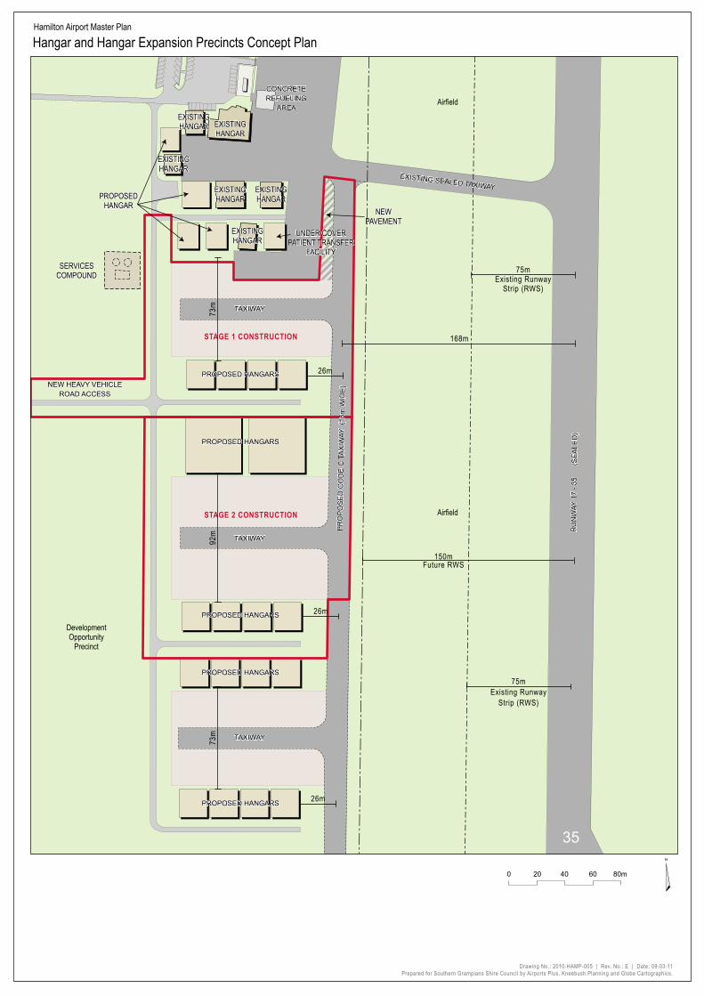
STAGE 1 CONSTRUCTION
STAGE 2 CONSTRUCTION
EXISTINGHANGAR
EXISTINGHANGAR
EXISTINGHANGAR
EXISTINGHANGAR
EXISTINGHANGAR
EXISTINGHANGAR
PROPOSED HANGARS
PROPOSED HANGARS
PROPOSED HANGARS
PROPOSED HANGARS
PROPOSED HANGARS
TAXIWAY
TAXIWAY
TAXIWAY
RU
NW
AY 1
7 - 3
5
(S
EA
LED
)
CONCRETEREFUELING
AREA
NEW HEAVY VEHICLEROAD ACCESS
EXISTINGHANGAR
EXISTINGHANGAR
EXISTINGHANGAR
EXISTINGHANGAR
EXISTINGHANGAR
EXISTINGHANGAR
PROPOSED HANGARS
PROPOSED HANGARS
PROPOSED HANGARS
PROPOSED HANGARS
PROPOSED HANGARS
TAXIWAY
TAXIWAY
TAXIWAY
PR
OP
OS
ED
CO
DE
C T
AX
IWAY
(15
m W
IDE
)P
RO
PO
SE
D C
OD
E C
TA
XIW
AY (
15m
WID
E)
35
RU
NW
AY 1
7 - 3
5
(S
EA
LED
)
EXISTING SEALED TAXIWAYEXISTING SEALED TAXIWAY
CONCRETEREFUELING
AREA
NEW HEAVY VEHICLEROAD ACCESS
PROPOSEDHANGAR
PROPOSEDHANGAR
UNDER COVERPATIENT TRANSFER
FACILITY
UNDER COVERPATIENT TRANSFER
FACILITY
DevelopmentOpportunity
Precinct
Airfield
Airfield
168m
73m
73m
92m
SERVICESCOMPOUNDSERVICES
COMPOUND
NEWPAVEMENT
NEWPAVEMENT
75mExisting Runway
Strip (RWS)
75mExisting Runway
Strip (RWS)
26m
26m
26m
150mFuture RWS
Hamilton Airport Master Plan
Hangar and Hangar Expansion Precincts Concept Plan
¤
Drawing No.: 2010-HAMP-005 | Rev. No.: E | Date: 09-03-11Prepared for Southern Grampians Shire Council by Airports Plus, Kneebush Planning and Globe Cartographics.
0 20 40 60 80m

Appendix 7

HE
NS
LEY
P
AR
K
RD
Hensley ParkHomes
TERMINAL
CARPARK
HANGAR
HANGAR
HANGAR
HANGAR
HANGAR
HANGAR
AIRCRAFTPARKING
PAVED APRONAREA
AIRCRAFTPARKING
APRON
SEALED TAXIWAY
SEALED TAXIWAY
RUNW
AY
17 -
35
(SEA
LED)
CONCRETEREFUELING
AREA
SEALED APRON
RESIDENCE PLANTSHED
EQUIPMENT FLARESHED
N D B
RUNWAY 10 - 28
GRAV
EL TA
XIW
AY
FUELFACILITY
CODE
C TA
XIW
AY
(15
m PA
VEME
NT &
52m
TAXI
WAY
STR
IP)
Airfield
HangarPrecinct
Airfield
Airfield
Hensley ParkHomes
Fire BasePrecinct
TERMINAL
CARPARK
HANGAR
HANGAR
HANGAR
HANGAR
HANGAR
HANGAR
AIRCRAFTPARKING
PAVED APRONAREA
AIRCRAFTPARKING
APRON
SEALED TAXIWAY
SEALED TAXIWAY
RUNW
AY
17 -
35
(SEA
LED)
CONCRETEREFUELING
AREA
SEALED APRON
RESIDENCE PLANTSHED
EQUIPMENT FLARESHED
N D B
RUNWAY 10 - 28
GRAV
EL TA
XIW
AY
FUELFACILITY
CODE
C TA
XIW
AY
(15
m PA
VEME
NT &
52m
TAXI
WAY
STR
IP)
PROPOSED HANGAR
EXPANSION
PROPOSED HANGAR
EXPANSION
PROPOSED HANGAR EXPANSION
PROPOSED HANGAR EXPANSION
SERVICESCOMPOUNDSERVICES
COMPOUND
Fire BasePrecinct
Hamilton Airport Master Plan
0 25 50 100m ¤
Services Layout Plan (Fire Hydrant & Waste Water Reticulation)
Drawing No.: 2010-HAMP-013 | Rev. No.: B | Date: 09-03-11Prepared for Southern Grampians Shire Council by Airports Plus, Kneebush Planning and Globe Cartographics.
Aerodrome Study Area NDB (and 150m Buffer) Proposed 300m wide runway strip Existing Buildings New Buildings New Access Road Airfield Waste Water Reticulation Fire Hydrant Reticulation
!

Appendix 8


Appendix 9

HEN
SLEY
P
ARK
R
D
MENZELS RD
MENZELS RD
HE
NS
LEY
P
AR
K
RD
FORTS RD
Hamilton Airport Master Plan
Australian Noise Exposure Forecast
0 500 1,000 1,500m
DRAFT
Drawing No.: 2010-HAMP-011 | Rev. No.: B | Date: 09-10-10Prepared for Southern Grampians Shire Council by Airports Plus, Kneebush Planning and Globe Cartographics.
ANEF 15
ANEF 20
ANEF 25
Aerodrome Study Area ANEF 15 ANEF 20 ANEF 25 ANEF 30 ANEF 35 ANEF 40 ANEF 45
¤