Final Report of Findings - nhstateparks.org
106
June 2018 Coos County Trails Network Project Final Report of Findings 2016 - 2018
Transcript of Final Report of Findings - nhstateparks.org

June 2018
Coos County Trails Network Project
Final Report of Findings 2016 - 2018

This project has been funded the New Hampshire Charitable Foundation, The Department of Natural and Cultural Resources Division of Parks and Recreation Bureau of Trails, and the United States Department of Agriculture Rural Development. During the course of this project North Country Council created an on-road ATV study, created a survey instrument, conducted interviews of stakeholders, collected data on a variety of sources, facilitated a public meeting to present draft results, and created a working group to collaborate on the planning process. The working group will be convened throughout the planning process to provide feedback and ensure that the work is on a proper trajectory.

Table of Contents INTRODUCTION .......................................................................................................................... 1
Background ............................................................................................................................................... 2
RECREATION TRENDS .................................................................................................................. 2
Non-Motorized Use ............................................................................................................................... 2
Motorized Use ....................................................................................................................................... 5
Types of Use .......................................................................................................................................... 6
Extent of Trails ...................................................................................................................................... 9
Land Base Ownership .......................................................................................................................... 12
IMPACTS OF TRAIL NETWORKS ..................................................................................................... 14
Natural Resources ................................................................................................................................... 14
Hiking .................................................................................................................................................. 16
Equestrian ........................................................................................................................................... 16
Mountain Biking .................................................................................................................................. 16
OHRV/Snowmobile Impacts ................................................................................................................ 16
Social Impacts ......................................................................................................................................... 17
Shared Experiences ............................................................................................................................. 17
Health Impacts ........................................................................................................................................ 18
Economic ................................................................................................................................................. 18
OHRV Economic Impact ...................................................................................................................... 21
Snowmobiling Economic Impact ......................................................................................................... 22
Mushing Economic Impact .................................................................................................................. 23
FINANCIAL RESOURCES .............................................................................................................. 24
APPLICABLE LAWS AFFECTING THE USE OF TRAILS ............................................................................. 27
OHRV & Snowmobile Regulations .......................................................................................................... 28
Enforcement of OHRV and Snowmobile Laws .................................................................................... 31
Sound Levels and Tests ....................................................................................................................... 31
Accidents ............................................................................................................................................. 31
Equestrian Regulations ........................................................................................................................... 33
Hiking and Walking Regulations .............................................................................................................. 33
US Forest Service ................................................................................................................................ 33
Wilderness Regulations ....................................................................................................................... 34
Thru-Hiking Permits and Regulations (Appalachian Trail) .................................................................. 35

NH Hike Safe Program ......................................................................................................................... 35
Rail Trails ............................................................................................................................................. 35
Paddling and Boating Regulations ...................................................................................................... 36
Biking Regulations ............................................................................................................................... 38
UNOFFICIAL TRAIL RULES AND ETIQUETTE ....................................................................................... 40
INTERVIEW DATA ..................................................................................................................... 42
When asked to elaborate .................................................................................................................... 50
Connectivity ........................................................................................................................................ 53
WORKING GROUP .................................................................................................................... 54
Summary of Discussions ......................................................................................................................... 55
Development of Vision and Guiding Principles ....................................................................................... 56
VISION .................................................................................................................................................. 56
GUIDING PRINCIPLES ............................................................................................................................... 56
Identified Priority Needs, Issues & Concerns .......................................................................................... 57
SUMMARY ............................................................................................................................. 61
RECOMMENDATIONS................................................................................................................. 61
Planning Framework ............................................................................................................................... 62
Engagement Process ............................................................................................................................... 64
Addressing Conflict ................................................................................................................................. 65
Addressing Carrying Capacity ................................................................................................................. 66
Asset Inventory ....................................................................................................................................... 67
Economic Impact Assessment ................................................................................................................. 69
Needs Assessment and Analysis Existing Conditions .............................................................................. 71
Assisting with Decision Making ............................................................................................................... 72
Trail Entry Point Sign Consistency ........................................................................................................... 73
Coos County Trail Network Symposium ................................................................................................. 74
Comprehensive Coos County Trails Network Plan .................................................................................. 74
Systematic Understanding of Compatible Use ....................................................................................... 75
Increased Volunteerism .......................................................................................................................... 76
Funding Source Evaluation...................................................................................................................... 76
SCOPE OF WORK COMPREHENSIVE TRAILS PLAN FOR COOS COUNTY ..................................................... 77
Purpose and Goals .................................................................................................................................. 77
General Information and County Background ........................................................................................ 77

VISION .................................................................................................................................................. 77
GUIDING PRINCIPLES ............................................................................................................................... 77
IDENTIFIED PRIORITY NEEDS, ISSUES & CONCERNS ...................................................................................... 78
Specific Task Requirements .................................................................................................................... 79
APPENDIX .............................................................................................................................. 83
ON-ROAD OHRV SAFETY REPORT ............................................................................................... 85
WORKS CITED ......................................................................................................................... 92


The Coos County Trails Project began in 2016 with an on-road ATV Study, conducting research, holding stakeholder interviews, and the development of a Scope of Work for Coos County Comprehensive Trails Plan. The project was expanded to include key processes that would assist in managing outdoor recreation growth through stakeholder collaboration. There has been a boom in the interest of trail activity including mapping efforts, economic impacts, community conflicts, studies in recreational value, and the emerging businesses that play a significant role in the industry. The trails project recognized that there are many longstanding needs and key points made for trails in the region. Among these needs are inventorying assets, increasing funding, diversifying opportunities, maintaining and constructing trails, private land, and compatible use. Many have been carried down since the 1970s,including the need for master planning and the need to provide adequate trail user services. Progress has been seen on each of these issues with each passing decade. There is no time like the present to develop a comprehensive plan that includes action regarding these longstanding goals and visions that have always been left unfinished. The following findings and recommendations are a snapshot of the rapidly changing trail environment in Coos County. It will be essential to collaborate fully with all stakeholders to promote and guide the healthy and sustainable development of the Coos County Trail Network. This collaboration will bring a positive contribution to building the Coos County Comprehensive Trails Plan. The plan will need to take into consideration property owners, trail managers, trail users, community, organizations, diverse trail uses, and the natural environment. It will need to be a steady, deliberative process that is often revisited, adapted where needed, and implementated. The Coos County Trails Network can be considered an opportunity for the North County to enter into an era of change. This change built upon outdoor recreation will connect people to place through a resilient and sustainable network of diverse trails. Much work remains to develop a plan that is fully informed by the public and stakeholders. This plan will be pivotal to guide the development of the growing Coos County Trail Network.


1 | P a g e
Introduction Coos County is the largest County in the state, encompassing 1,801 square miles. The County is comprised of nineteen towns, one city, and twenty-three unincorporated places. For over 200 years County residents continued to have a strong sense of place and to cherish the bounty of natural resources that the County was built on. The County is home to the highest peak in the Northeast, Mount Washington, at 6,289 feet. It is bordered to the North by Canada, to the West by Vermont, and to the East by Maine. Coos County is home to a population of 32,219 representing two percent of the population of New Hampshire (U.S. Census Bureau, 2016). Since 1970, the County has experienced a decline in population resulting in an out-migration of six percent while over the same period New Hampshire’s population has increased by eighty percent. There is a new sense of optimism outdoor recreation brings to the region as the County is in the midst of an economic reinvention based on the foundation of outdoor recreation. This trail project originated from the regional plan “A Plan for New Hampshire’s North Country” adopted in 2014. The plan identified the world-class trails throughout the region spanning all user types. The plan further highlights the opportunities these trails allow to increase the resiliency of Coos County, boost the regional economy, and create healthy outdoor activities for residents and visitors alike. In general, a Comprehensive Trails Plan provides overall direction for developing a coordinated and effective trail network which includes not just the physical location of existing networks but provides guidance on future planning efforts, best practices, and priorities. The purpose of this report is to present the findings of the project and foundation of data that a future trails plan will be built on. This plan will inform work toward creating a resilient trail network in Coos County. North Country Council staff used research, reports, field work, and working group sessions to provide a complete picture of the impacts Coos County trails have on people and place. This report also focuses on the people and groups who have organized clubs, associations, and coalitions build, manage, use and maintain the trails. These groups have a passion for the outdoors and for supporting and improving the trails for use by residents and visitors to the region. The explosion of trail-use in the Coos County has affected these groups and their communities in various ways. This report offers a means to understand how these communities have been impacted and helps lay the groundwork for how best to move forward to create a resilient, sustainable trail network in Coos County for all stakeholders including residents, users, and local communities.

2 | P a g e
Background The natural and scenic beauty of Northern New Hampshire has been a draw for visitors since the late nineteenth century. The paper industry was steadfast of the economy in Coos County for much of its history, supplying thousands of jobs for Coos County residents. Today, the number of jobs in the paper industry has dwindled, changing not only the economy of the region but also the relationships among communities. North County communities once tightly tied together through the paper industry are now learning to strengthen partnerships with trail groups and the many networks to stabilize and grow the economy through outdoor recreation. The sustainability of the trail network relies on developing and maintaining positive collaborations between user groups, communities, and landowners. The North Country is home to a world-class trail network that has been built around the region’s natural environment. Trails are the backbone of the outdoor recreation economy in Coos County and allow a diverse range of uses, economic opportunities, and improved quality of life for residents. A wide range of outdoor recreation opportunities are available within the county including hiking, biking, off-highway recreational vehicle (OHRV) riding, snowmobiling, cross-country skiing, mushing, horseback riding, snowshoeing, and paddling. These activities attract New Hampshire residents as well as many other visitors from New England and beyond. To visitors, they offer opportunities to interact with communities and the natural environment while experiencing the outdoors.
Recreation Trends Outdoor recreation organizations were established to promote, conserving, maintaining, and building trail networks in the North Country since the late 19th century. One of the first major outdoor organizations to be founded was the Appalachian Mountain Club founded in Boston in 1876 by Edward Pickering and thirty-three other outdoor enthusiasts. The Weeks Act was a foundational piece of legislation that helped spur the protection of natural areas and manage them for recreational uses. The Weeks Act authorized government agencies to purchase land that was necessary for protecting river watersheds and headwaters and allowed for these lands to be administered as National Forest areas. Up until the mid-twentieth century, these organizations in the region were focused on non-motorized recreation, especially hiking. New developments such as snowmobiles in the 1960s and mountain bikes in the 1980s began to diversify the different trails created throughout Coos County. The 1990s increased the development of OHRVs, becoming a popular form of recreation nationwide and continues to grow to this day.
Shared Experiences
Connection to nature and scenic beauty
Quality of life improvement
Economic benefits
Connectivity to communities
Creating community buy-in is critical to the planning process because local resident will be the ones directly impacted by new activities and developments.

3 | P a g e
Shared experienced sought after by trail users vary according to a method of use, ability, and age. Despite differences, many individuals share similar reasons why trails are important to the County, communities and personally. Trails are a vital, growing aspect that allows people to access nature and connect with friends and family to share experiences. In 2013 a study completed for the Outdoor Industry Association recognized the following in US adults that
participate in outdoor recreation by type in 2012. It is noted that over have of the adult population participate in some form of outdoor recreation.
Non-Motorized
Trail sports 27.9% Bicycling 29.2% Camping 18.7% Snow sports 7.9%
Water sports 12.8% Any 51.9%
Motorized
Motorcycling 9.3% Off-road riding 12.0% Boating 12.1% Snowmobiling 2.2% RV'ing 6.1%
Any 26.8%
Any Outdoor 57.5%
Non-Motorized
Trail sports 6.9 Bicycling 24.6 Camping 11.0 Snow sports 10.6 Water sports 7.0
Total 40.3
Motorized Motorcycling 16.5 Off-road riding 16.2 Boating 14.0 Snowmobiling 7.7
RV'ing 14.1 Total 23.2
Percent of US adults who
participate in outdoor
recreation, by type of
recreation, 2012.
Average number of trips for US adults who
participate in outdoor recreation, by type of
recreation, 2012.
A finding of this project was that regardless of user group; greater education is needed, proper sound maintenance and construction methods are key, and respect for relationships is vital to a positive experience.

2 | P a g e
NON-MOTORIZED USE Non-motorized outdoor recreation has been in existence throughout the world since early explores set out on adventures to discover new land. Through the decades people have been spending time outdoors to meet the basic needs to survive and exploration via boat, horse, foot and more. Although in our modern world we rely much less on the need to hunt, fish and gather to survive we still spend a significant amount of time outdoors exploring and seeking new experiences.
The Outdoor Foundation data on the number of New Hampshire residents who participate in active outdoor recreation. This report was first published in 2006 but provides a valuable snapshot of the scope and scale of non-motorized activity on a state-wide level.
New Hampshire Residents Participate in Active Outdoor Recreation
Activity Category Number of Participants % of Population
Bicycling 241,000 24%
Camping 238,895 24%
Fishing 142,149 13%
Hunting 51,116 5%
Paddling 225,662 22%
Snow Sports 254,233 25%
Trail 349,570 35%
Wildlife Viewing 445,000 42%
Source: Outdoor Foundation, 2006
Annual Outdoor Outings, outdoor participants Age Six+
Number of Outings Percentage
One to Three 12%
Four to Eleven 20%
Twelve to Twenty-three 14%
Twenty-four to Fifty-one 18%
Fifty-two to 103 15%
104 to 259 14%
260+ 7%
Source: Outdoor Foundation, 2017

3 | P a g e
The following chart presents the average participation of the population by regions. Despite only five percent of New England active in recreation, this translates to around 735,000 people recreating annually.
Region Participation Rate (Ages 6+)
East North Central 15%
East South Central 5%
Middle Atlantic 13%
Mountain 8%
New England 5%
Pacific 17%
South Atlantic 19%
West North Central 8%
West South Central 11%
Source: Outdoor Foundation, 2017
The majority of outdoor participants have been part of the outdoor community for more than ten years. It was estimated that the average participant had twenty-one years of experience enjoying outdoor recreation.
Figure 1 Outdoor Foundation, 2017
14%
11%
13%
4%
58%
Time Spent as an Outdoor Participant
1 year
2-3 Years
4-6 years
7-9 Years
10+ Years

4 | P a g e
Below presents data on the spending habits of those participating in outdoor recreation ages six and over. Expenditures for equipment and accessories for non-motorized recreation, U.S.
Expenditures for equipment and accessories for motorized recreation, U.S.
Source: The Economic Contributions of Outdoor Recreation: technical Report on Methods and Findings March, 2013 Outdoor recreation plays an increasingly significant role in people’s lives, improving one's health, allowing individuals to strengthen relationships with friends and family, builds memories and traditions, and allows people to experience the natural world. The Appalachian Mountain Club manages 1,800 miles of trail from Virginia to Maine including the Appalachian Trail. The AMC 2016 Annual Report provides a view of recreation along a major portion of the national scenic trail.
181,324 overnight visitor experiences at lodges, huts, shelters, camps, cabins
275,000+ constituents including members, guests, advocates, supporters
39,303 volunteer trail hours donated
8,000 volunteer-led activities including chapter and Adventure Travel programs
89,853 kids experienced the outdoors through AMC programs and destinations
124,137 days of youth experiences provided (Appalachian Mountain Club, 2016)

5 | P a g e
MOTORIZED USE Motorized recreation has been a constant in New Hampshire since the late 1950s. The two major activities of snowmobiling and OHRVing have differing seasons, laws, and age of the sport, but they have become known as ways for families and individuals of all ages and abilities to access and enjoy outdoor recreation. Snowmobiling first took off in New Hampshire in 1959. Within a decade clubs were established across the state. The New Hampshire Snowmobile Association, or NHSA, was created to act as a support system and advocate for the sport at a state-wide level. The many snowmobile clubs in the state have evolved and expanded since the late 1950s to have thousands of members, a variety of events supporting different causes and fundraising efforts, and a major economic impact to the state (New Hampshire Snowmobile Association, https://nhsa.com/nhsa-history/). In the state OHRV trails have been managed since the 1970’s, just after the invention of what was called All-Terrain Vechicles (ATV). This brought about the establihment of clubs specific to OHRV’s in the mid 1990’s as this recreational activity grew. In 2001 the State of New Hampshire recognized that OHRVs use was on the rise as a recreatioal activity and since OHRV registrations in New Hampshire have steadily risen over the past seventeen year. Jericho Mountain State Park was established in Berlin in 2006 due to this growing interest and demand for motorized recreation in the region. Jericho evolved through the City government and opened with fifteen miles. Jericho is the first park of its kind in the Northeast and has expanded to seventy-five miles of trails and overnight camping sites. The development of Jericho was a pivotal point in OHRV establishing itself as a popular three-season recreation activity in Coos County. In 2013, Jericho made the connection to an estimated 1,000 miles of trails as part of the Ride the Wilds network. Ride the Wilds was established in 2013 to connect and market the many different OHRV trail networks in Coos County. This network is made up of eleven major clubs who work to construct, maintain and patrol the trails. Within the connected network are more than 1,000 miles of trails that make all day riding possible with opportunities for food, supplies, and services along the way. OHRV use has been said to be a building economic driver in a region in the midst of economic transition.
64,681 72,426 77,422
55,242
84,073
2013 2014 2015 2016 2017
Total Snowmobile & OHRV Registrations
Figure 2 New Hampshire Fish and Game

6 | P a g e
Current Coos County Trail Network Resources
Coos County is home to a wide array of trail resources that are some of the most scenic and captivating experiences in the Northeast. The Trail networks of Coos County connect with well-established organizations such as the Appalachian Mountain Club, Randolph Mountain Club, Connecticut River Paddlers Trail, Pittsburg Ridge Runners, and North Country ATV Club along with smaller local clubs with locally-maintained trail networks supported through volunteers and dedicated members. Both types of groups are equally valued by users and the communities as a whole for their contributions to the maintenance and stewardship of the trails.
Coos County has a rich history of trail use dating back to the 1800’s. Trails originally used as the main routes of travel evolved into attractions for visitors to explore the scenic beauty and clean air of the
region. Today, there is a multitude of trails to access throughout the county, with many active uses coexisting across the region overlapping in physical areas.
TYPES OF USE According to the NH Outdoors 2008-2013 Statewide Comprehension Outdoor Recreation Plan (SCORP) by NH OEP, more people are participating in a wider variety of activities now than was true 10-20 years ago. This increase in outdoor enthusiasts has led to an increase in diversified activities spanning both motorized and non-motorized recreation. The Comprehensive State Trails Study of 1997 provided a baseline measure for the composition of trails throughout New Hampshire.
The composition of statewide trails in the 1997 study has not been updated since.
55.1%
25.7%
10.0% 3.2% 1.6% 1.5% 1.5% 0.6%
Snowmobile Hiking Bicycling X-Country Moto-Bike 4 Wheel /ATV
MountianBike
Equestrian
1997 Composition of NH Trail Types
Figure 3 Comprehensive Statewide Trails Study, June 1997, New Hampshire Office of State Planning
Figure 2 New Hampshire Fish and Game

7 | P a g e
There is currently no state or Coos County wide breakdown of trail mileage. This information has proven to be a challenge to acquire. Below is information regarding recreational trails in Coos County that was available via NH GRANIT. A further breakdown of specific use was not available in a central location. It should be mentioned that this is not a complete dataset and should not be considered fully exhaustive.
Coos County Recreational Trails
Trail Type Miles (2016) Percent of Total (2016)
Multi-Use 474.21 15.5%
Multi-Use Non-Motorized 63.81 2.1%
Single-Use 2,531.22 82.5%
Total 3,069.24 100.0%
Source: NH Recreational Trails Layer, 2016
Source: 1997 Statewide Trails Study – Chapter 8 Issues, Goals, Recommendations, and Evaluations & Conclusions
8 | P a g e

9 | P a g e
EXTENT OF TRAILS There is an estimated 3,000 miles of trails across the many different networks and uses in Coos County. These networks connect the different communities and also connect with our neighboring states and Canada. Trails cross a wide array of land owned by Federal, State, municipal, and private groups having various configurations of easements, and permissions. Connectivity is a linchpin of the system, connecting people to places, services, and other destinations. During the research phase of this project, we learned that for many people, connectivity means increased accessibility. Trails with better accesses to be used by more diverse and differently-abled populations. Connectivity means working with other groups to link new places for people to enjoy. This allows more people to access new landscapes and have new experiences. Interconnected trails also can create a collective impact by bringing together nearby towns and linking them to a larger system. In other ways, cellular connectivity helps first responders get to emergency situations on the trails faster and with less difficulty. Listed below are some of the trail systems within Coos County. Androscoggin River Trail 168 miles Management: Androscoggin River Watershed Council Use Types: canoeing, kayaking, camping, fishing, wildlife viewing
Cape Horn State Forest 2,043 acres Management: NH Department of Natural & Cultural Resources Use Types: hunting, camping, hiking, day use, wildlife viewing
Connecticut Lakes State Forest 1,812 acres Management: NH Department of Natural and Cultural Resources Use Types: hunting, hiking, fishing, cross country skiing, kayaking, canoeing, snowmobiling, ATVing
Connecticut River Paddlers Trail 111 miles (Approx. in Coos County County) Management: The Vermont Conservancy Use Types: canoeing, kayaking, fishing, wildlife viewing, primitive camping
Dixville Notch State Park 127 Acres Management: NH Department of Natural & Cultural Resources Use Types: hiking, walking
The Fourth Connecticut Lake 1.7 Miles Management: The Nature Conservancy, N NH Department of Natural & Cultural Resources Use Types: hiking,
Connectivity will remain a
major talking point as
communities and clubs
seek to organize their trails
into connected networks
to allow users to access
new places, services and
area.

10 | P a g e
Great Glen Trails 24 miles Management: Great Glen Outfitters Use Types: hiking, mountain biking, walking, cross country skiing, fat biking
Jericho Mountain State Park 85 miles Management: NH Department of Natural & Cultural Resources Use Types: Multi-use ATV, UTV, TB, trucks, jeeps, snowmobiles, equestrian, sled dogs, biking, walking
Kauffmann Forest 3.6 miles Management: Society for the Protection of New Hampshire Forests (SPNHF), Percy Summer Club Use Types: cross country skiing, hiking, hunting, fishing, snowmobiling, snowshoeing, canoeing, kayaking
Milan Hill State Park 5.3 miles Management: NH Department of Natural & Cultural Resources Use Types: cross-country skiing, snowshoeing, hiking, dog walking Moose Brook State Park 755 Acres Management: NH Department of Natural & Cultural Resources Use Types: mountain biking, hiking, fishing, swimming, and camping
Mount Magalloway 2.2 miles Management: NH Department of Natural & Cultural Resources Use Types: non-motorized, hiking
Northern Forest Canoe Trail 72 miles (NH), (740 miles through ME, NH, VT, QC, NY) Management: Northern Forest Canoe Trail volunteers Use Types: canoeing, kayaking, fishing, camping, wildlife viewing
Pittsburg Snowmobile Trails 250 miles Management: Pittsburg Ridge Runners Use Types: snowmobile
The Cohos Trail 165 miles Management: Cohos Trail Association Use Types: hiking
Presidential Ridge Rail Trail 20 miles Management: NH Department of Natural & Cultural Resources Use Types: skiing, hiking, horseback riding, biking, dog sled, snowmobiling and snowshoeing ATV use allowed only in winter with snow cover

11 | P a g e
Randolph Trail Network 102 miles Management: Randolph Mountain Club Use Types: non-motorized, primarily hiking
Second College Grant 25 miles Management: Dartmouth College Outdoor Programs Office Use Types: non-motorized hiking, biking, snowshoeing, cross-country skiing, snowmobile, canoeing, kayaking, hunting, fishing
Shelburne Trail Network 25 miles Management: Shelburne Trails Club Use Types: non-motorized uses hiking, snowshoeing, cross-country skiing, biking
Success Pond Trail 20 miles Management: Androscoggin Valley ATV Club Use Types: motorized including OHRV, snowmobile
The Clarksville Freedom Trail 1 mile Management: Volunteers Use Types: non-motorized, hiking, walking
Table Rock Trail 0.3 miles Management: Volunteers Use Types: non-motorized, hiking
Twin Mountain Trails 85 miles Management: Twin Mountain Snowmobile Club, White Mountain National Forest Use Types: snowmobile, hiking, biking
Upper Coos Recreational Rail Trail 10 miles Management: Colebrook Ski Bees, NH Department of Natural & Cultural Resources Use Types: cross country skiing, hiking, horseback riding, biking, sledding, OHRV, snowmobiling, snowshoeing
Washburn Family Forest 5 miles Management: Society for the Protection of New Hampshire Forests (SPNHF) Use Types: hiking, fishing, hunting, cycling, snowmobiling, snowshoeing, cross country skiing
White Mountain National Forest 750,000 acres Management: White Mountain National Forest, U.S. Forest Service Use Types: hiking, mountain biking, cross country skiing, camping

12 | P a g e
LAND BASE OWNERSHIP New Hampshire has 9,000 square miles of land for outdoor recreation (NH State Parks, 2013). Additionally, New Hampshire has one million acres of private forest and agricultural land available for recreational use. This includes 730,000 acres of White Mountain National Forest with over 500 miles of trails in Coos County. Coos County covers the top fifth of the state and is composed of 1,830 square miles of Federal, State, municipalities, and private land. The northern part of the state tends to be dominated by large tracks of publicly-owned lands such as White Mountain National Forest and large tracts of privately held lands, much of which belongs to large land management companies. Landowners are the gatekeepers of the Coos County trails network. The research revealed that the majority of trails in Coos County run over private land. Throughout the research, it was recognized that there would be no trail network without the support of private landowners. Landowners are often times hesitant to allow access to their lands because of concern over negative land impacts, congestion, and unwanted behavior by users. Clubs have worked to create relationships with landowners by properly maintaining access routes, posting signs prohibiting unwanted behavior, patrolling, and reporting reckless users. The following presents an updated map of the recreation trails in Coos County overlaid on the different types of land ownership. This information was prepared by North Country Council staff with information from 2016 via NH GRANIT. It should be mentioned that this is not a complete dataset and should not be considered fully exhaustive.
Ownership - Protection Type Acres (2013)
Federal - Fee Ownership 263,124
Federal - Easement 2,392
State - Fee Ownership 92,456
State - Easement 156,642
Municipal - Fee Ownership 8,699
Municipal - Easement 16,933
Private Non-Profit - Fee Ownership 44,166
Private Non-Profit Easement 9,319
Other Public/Quasi-Public Entity - Fee Ownership 0
Other Public/Quasi-Public Entity - Easement 538
TOTALS 594,267
Source: NH GRANIT - Conservation Lands, 2013

13 | P a g e

14 | P a g e
Impacts of Trail Networks Coos County was historically a center of hiking and snowmobiling, and the new growth in different types of trail use has boosted the numbers of people coming into the region to new heights. This boost in recreation trail seekers brings with it new expectations and impacts. As with any development or growth consideration must be given to the potential impacts both positive and negative on all aspects. Growing recreational uses to ensure the sustainability of this network from the perspective of both natural resources and communities to which support them is critical. Interviews conducted by North Country Council staff with trail user groups found no overwhelming concern for overuse leading to immediate impacts. There were found to be isolated locations where high usage has led to significant impacts such as illegal or unsafe parking, trail erosion, quality of life concerns, and user-resident conflicts. Research and the collected data has shown that trail use can both positively and negatively impact natural resources, infrastructure, local communities, and economies. Positive impacts potentially include improved health from outdoor activity, boosted property values, job and business growth, and opportunities for volunteering and community involvement. Negative impacts potentially include soil erosion, wildlife habitat fragmentation, noise pollution, dust pollution, and increased burdens placed on community services and infrastructure. Some communities with growing on-road OHRV use have not had an organic process to establish road accesses as others. The community of Berlin had legalized OHRV use on their road network over a period of years through long-term public processes. The neighboring community of Gorham has become a focal point of trail conflict in recent years due to its wide array of lodging establishments and strategic location near the many trail connections located in proximity. Despite these issues, it could be very productive for communities to come together with their residents to work on the major issues regarding OHRV ridership. It is important to not stereotype riders and to collaborate to find solutions to the challenges at hand.
Natural Resources Trails are an essential component of outdoor recreation. Trails provide access to off-road areas for increased recreational opportunities and protect resources by concentrating use on hardened surfaces. Major challenges for trail groups are how to maintain trails best, mitigate degradation, and manage recreational use. Different types of trail use lead to varying types of and levels of impact on the surrounding area. Some of the impacts trails can have on the natural environment include:
Vegetation loss and changes
Soil compaction
Root exposure leaving plant species vulnerable
Trail widening
Erosion

15 | P a g e
These distributed impacts are well-articulated in an article published in the Journal of Park and Recreation Administration:
Different Forms of Trail Resource Impact and Their Ecological and Social Effects
Effect
Form of Impact Ecological Social
Soil Erosion Soil and nutrient loss, water turbidity/sedimentation, alteration of water runoff, most permanent impact
Increased travel difficulty degraded aesthetics, safety
Exposed Roots Root damage, reduces tree health, intolerance to drought
Degraded aesthetics, safety
Secondary Treads Vegetation loss, exposed soil Degraded aesthetics
Wet Soils Prone to soil puddling, increased water runoff
Increased travel difficulty, degraded aesthetics
Running Water Accelerated erosion rates Increased travel difficulty
Widening Vegetation loss, soil exposure Degraded aesthetics
Visitor-Created Trails Vegetation loss, wildlife habitat fragmentation
Evidence of human disturbance, degraded aesthetics
Source: Marion and Leung, Fall 2001 Trail placement, the type of use, and the amount of use can have both a negative and positive impact on wildlife depending on the situation. Impacts that can potentially be seen are fragmentation of wildlife habitat, and both avoidance and attraction behavior, for example, bears being conditioned to human food sources. The majority of impacts are a result of the trail corridors themselves and can result in impacts that are restricted to the physical corridor and can extend beyond into the surrounding area. Some of the common impacts include:
Introduction of invasive species
Changes in surface water drainage
Disturbance of wildlife
Damage to threatened, rare and endangered species Some of the factors that influence the extent of impact on natural resources are the type, amount, and behavior of use combined with the physical environmental characteristics that the use is occurring within. Such as steep slopes, wet areas or sensitive habitat areas.

16 | P a g e
HIKING Hiking is one of the most widespread trail activities. In Coos County, some of the most heavily used non-motorized trails are in the White Mountain National Forest, which sees over 2 million visitors every year and has an estimated 500 miles of hiking trail within the County. Some of the impacts of hiking include (Pickering 2009):
Soil compaction and loss
reduced soil moisture
loss of organic litter
loss of ground cover vegetation, the loss of native plant species
Introduction of invasive species that change the vegetation composition
In some cases, human waste not properly disposed of from hikers can have social and biological impacts, especially near water sources.
EQUESTRIAN Equestrian usage makes up a small part of trail use in the County. Equestrian use on trails can have a major impact on natural resources, but due to low user levels in the region, the long-term effects are minimal. Many types of impacts from horses are similar to those from hiking, particularly soil compaction and erosion, loss of organic litter, loss of ground cover vegetation, loss of species, trail erosion and widening, and potentially the spread of invasive species and pathogens into natural
vegetation. A major difference, however, is the level of impact, the greater weight of horses can result in more damage to vegetation and soil than a lone hiker. (Pickering et al., 2009). As a result of greater weight, erosion and trampling-related impacts on vegetation have been found to be higher than hikers, mountain bikers and even some off-road motorcycles (Marion, 2006). Despite evidence that equestrian use causes issues with trail degradation and vegetation trampling, these issues remain few and far between in Coos County. The number of equestrians who use the trails in the region is minimal, with only occasional events where riders travel the trails together or are
traveling regularly over the trails.
MOUNTAIN BIKING Mountain bikes tend to impact trails similarly to hikers. These impacts include trail widening, soil erosion, and rutting. Another major impact seen in many regions is the creation of informal, or “bandit” trails. These informal networks of trails can create drainage and runoff issues, erosion issues, and cause damage to local vegetation. These informal networks tend to attract particular riding styles such as downhill riding and dirt jumping which affect local natural resources further (Pickering et al., 2009).
OHRV/SNOWMOBILE IMPACTS Stokowski and Lapointe, writing in “Environmental and Social Effects of ATV’s and ORV’s” summarize a variety of major trail impacts which are listed below:
The general impact of trail use can be summarized as, “Regardless of vehicle type (ATVs, ORVs, snowmobiles), research generally shows very similar impacts; differences in impact level is due

17 | P a g e
to intensity of use or use characteristics, in combination with the level of fragility of the affected environment.”
Trails quality impacts by trail use can be summarized as, “Trail erosion and compaction caused by off-road and all-terrain vehicles reduce the quality of recreational trails and require enhanced management action to develop and maintain safe, usable trails.”
Wildlife impacts by trail use can be summarized as, “Wildlife is negatively impacted by the presence and noise of ATVs, ORVs, and snowmobiles, although some mammals (deer, for example) may become, over time, habituated to these vehicles. Snow compaction also affects the survival and activities of small mammals.”
Lastly, the impacts of snowmobile users can be summarized as, “Studies show that snowmobiles compact insulating layers of snow and thus compromise the habitat of mammals living below the snow layer. Their noise also puts stress on large ungulates, including moose and deer.”
In 2008 the United State Department of Agriculture-Forest Service released a study titled Effects of All-Terrain Vehicles on Forested Lands and Grasslands. The study estimates that 5% of all recreation visits to all national forests are ATV use. This excludes the White Mountain National Forest where ATV use is prohibited. The study concluded through the testing of different equipment and scenarios that ATVs affect local natural resources. However, the levels of impact can be reduced through proper trails design and maintenance.
Social Impacts Access to trail networks can have a major impact on residents, visitors and the communities that trails pass through. The social impacts of a trail network can take many shapes depending on the network, user, connectivity, and location and can be both positive and negative. Impacts can include:
User and landowner conflicts
Community cohesion
Community placemaking
Improper disposal of trash, human waste
Increased financial burdens Trails can be a place of personal accomplishment, a pathway to a destination, or a gathering place for communities and families. Trails provide an opportunity for individuals from diverse interests to interact with each other and the natural world. Trails foster community involvement and volunteerism offering accessibility to individuals of all income groups and abilities. There can be conflict when different user groups interact out on the trails. Managing these conflicts in a non-biased and respectful manner is important to minimize negative social and community impacts.
SHARED EXPERIENCES Desired experiences sought after by trail users vary according to method of use, ability, and age. Despite some differences, many share similar reasons why trails were important to the County and to their
Knowing that trails are an essential and growing component of the North Country economy, high quality natural resources, proper design, construction and maintenance will be critical to sustainability.

18 | P a g e
communities. Trails are a vital aspect of communities that allow people to access nature, experience solitude, and connect with friends and family to share experiences. Trails help to develop relationships between people and place. Trail projects bring together many different groups including businesses, residents, local officials and advocacy groups to support and
utilize local resources. Trails can bring people together to enjoy their communities, the surrounding environment, and each other in new ways. Trails have enabled people to get out into nature and experience new landscapes and natural beauty. Opening trailheads and access-points close to residential neighborhoods can open residents to new places they would not normally visit or experience. Trails such as rail trails also
are relatively easy to traverse, allowing people of all levels of mobility and ability to experience what the outdoors has to offer. Having a variety of ways to enjoy the landscape is an important factor making Coos County trails special, enjoyed by all manner of use. Motorized and non-motorized trails have overlapping uses such as hiking, biking, cross-country skiing, snowshoeing, mushing, and snowmobiling and OHRVing. This variety allows users to revisit places time and again and to create new experiences
Health Impacts Outdoor recreation has a major positive impact on an individual’s health and wellbeing. It is known that regular exercise improves overall health, lengthens and increases individual’s quality of life. Regular physical activity lessens the risk for a range of diseases, and physical activity relieves symptoms of depression, anxiety, improves mood, and enhances well-being. In 2011 the results of the York University’s Study on the “Fitness and Health Benefits of Off-Road Vehicle Riding” confirmed that OHRVing contributes to individual and family emotional and physical well-being. This 2011 study was the first ever comprehensive study of this topic.
Economic Outdoor recreation is an important part of New Hampshire’s economy. Data from the Outdoor Industry Association shows that in 2016, outdoor recreation contributed $8.7 billion in consumer spending, $528 million in state and local tax revenue and created 79,000 direct jobs. New Hampshire communities recognize outdoor recreation as an asset, for both the economic opportunities it brings, the health benefits it provides and quality of life it contributes to. It is unsurprising that sixty-nine percent of New Hampshire residents participate in outdoor recreation (Outdoor Foundation, 2017).
Residents feel more ingrained in
a community when they are
encouraged to be involved in a
community-focused project like
a trails project.
The White Mountain
National Forest attracts
well over two million
visitors per year, while
NH State Parks can see
upwards of six million
visitors annually.

19 | P a g e
In Coos County, outdoor recreation is growing in importance as a foundational component of the economic base. Since 2010, a slight increase in the industry sector that includes recreation was seen while a more dramatic decline of almost 3.5% occurred in the manufacturing industry (U.S Census Bureau, 2016). Also, according to the Coos County Economic Index (produced by Plymouth State University) Coos County’s rooms and meals tax revenue has seen relative steady increase since 2012. This data provides an indication as to how the tourism sector is doing, but it does not capture day travelers or travelers staying in unreported accommodations. (Plymouth State University, 2016)
Another indicator that Coos County recreation economy is growing is the 6% growth from 1998 to 2015 in total private employment in industries that include travel and tourism (Headwaters Economics 2017).
Figure 5 Plymouth State University Coos County Economic Index
0.0%
5.0%
10.0%
15.0%
20.0%
25.0%
30.0%
35.0%
19
99
20
00
20
01
20
02
20
03
20
04
20
05
20
06
20
07
20
08
20
09
20
10
20
11
20
12
20
13
20
14
20
15
Percent of Total Private Employment in Industries that Include Travel & Tourism, Coos County, NH, 1998-2015
Figure 4 Plymouth State University Coos County Economic Index

20 | P a g e
Outdoor recreation has the potential to sustainably grow jobs and drive the regional economy if we continue to invest wisely and manage our parks, waters, and trails as an integrated network. Coos County is in the growth phase of this process. There is a great deal of activity bringing together trails into organized networks and to develop marketing to attract visitors from across the country and world. Natural amenities such as trails, parks, open spaces and wildlife habitat play a vital role in the tourism and recreation economy. Studies have shown that communities located near recently opened trail networks see boosts in local business. The many types of businesses experiencing this boost include lodging establishments, restaurants, bike rentals, and bed and breakfasts (McDonald and Brown, 2015). The recreation economy supports a wide variety of career options and opportunities. Spending on outdoor trips directly supports professional guides, outfitters, hotel owners, park managers, retail, and a variety of small businesses (Outdoor Industry Association, 2012). The New Hampshire recreation economy creates a great deal of jobs, tax revenue, and profit for recreation-related companies. The numerous economic benefits of trail networks can include increased property value of nearby homes, health benefits, and reduced environmental impact. Studies have shown that trail users spend money on food, beverages, camping, bike rentals, and accommodations, all of which stimulate the local economy. Current estimates show the recreation economy supporting 61,820 jobs, with $4.3 billion in direct spending (NH State Parks, 2013). The statewide park's network has an estimated six million visitors per year that contribute a total of $500 million to the New Hampshire economy. These contributions come in the form of tax revenues from restaurants, accommodations, retail trade, services, and transportation. The spending associated with these services provides direct support for more than 79,000 jobs statewide. (Outdoor Industry Association, 2017). Motorized recreational use in the state of New Hampshire has steadily increased over the last 20 years. This increased trend in off-highway recreational vehicles (OHRV) has created jobs, attracted many recreational users, and boosted tourism and the local economy in some communities. There has been much press about the transformation many communities in Coos County have been going through. Motorized recreation has been harnessed in some communities as an economic driver, and many other organizations have discussed these developments at length and how this opportunity may be replicated as in other parts of the country or expanded.

21 | P a g e
OHRV ECONOMIC IMPACT Plymouth State University worked with the Granite State All-Terrain Vehicle Association to develop an economic impact report on ATV/Trail Bike spending in New Hampshire for the seasons from 2002-2003. The report was able to estimate the amount each travel party was spending, and the estimated number of trips residents of New Hampshire and nonresidents were spending. The $123.8 million total ATV/Trail bike spending supported 1,995 direct full and part-time jobs annually, with an additional 384 full or part-time indirect jobs supported.
ATV/Trail Biking Travel party Spending July 2002 to June 2003
Direct % of Total
Eating and Drinking $21.6 17.4%
Accommodations $14.7 11.9%
Recreation $10.0 8.1%
Food Stores $9.5 7.7%
Other Retail Stores $37.5 30.3%
Ground Transportation $13.9 11.2%
Services & Other $16.6 13.4%
Total in Millions of Dollars $123.8 100.0%
Source: Plymouth State University, 2007
Jobs from Direct Traveler Spending July 2002 to June 2003
Direct % of Total
Eating and Drinking 483 24.2%
Accommodations 329 16.5%
Recreation 164 8.2%
Food Stores 48 2.4%
Other Retail Stores 728 36.5%
Ground Transportation 93 4.7%
Services & Other 150 7.5%
Total 1,995 100.0%
Source: Plymouth State University, 2007

22 | P a g e
Direct and Indirect Traveler Supported Employment
Sector Direct Indirect Total Jobs % of Total
Construction/Agriculture/Mining/Forestry 5 31 36 1.5%
Manufacturing 0 5 5 0.2%
Hospitality & Leisure 976 11 987 41.5%
Retail Trade 827 4 831 34.9%
Transportation/Utilities/Wholesale Trade/Information 2 47 49 2.1%
Fire 18 42 60 2.5%
Services 88 157 245 10.3%
Government 79 87 166 7%
Total 1,995 384 2,379 100.0%
Source: Plymouth State University, 2007
SNOWMOBILING ECONOMIC IMPACT The New Hampshire Snowmobile Association and Plymouth State University collaborated on an economic impact analysis of the Snowmobile industry in New Hampshire in 2011. This report highlighted the snowmobiling industry as a major driver of the Coos County and Grafton County economies. Listed below are some of the main highlights.
Snowmobiling has an economic impact of $586 million on the state annually.
Spending by snowmobilers was 0.3% of the gross state product and more than 5.2% of all travelers spending in the state.
Snowmobile traveler spending supported 2,394 direct full and part-time jobs, while indirect spending supported an additional 680 full and part-time jobs.
Average spending per visitor per day in New Hampshire was $79.00 per resident and $114.00 from non-residents. In addition to spending on their trips, each snowmobiler spends $1,307 annually, and each out of state snowmobiler spent $1,179 annually on equipment, clothing, club membership, insurance, and state licensing fees.

23 | P a g e
MUSHING ECONOMIC IMPACT The Institute for New Hampshire Studies at Plymouth State University released a Financial Impact Study on the Mushing Community in New Hampshire in 2011. The report tracked the financial impact through surveys and interviews surrounding three separate events throughout the mushing season. The report identified a multiplier factor for both spectator spending and musher spending throughout the year. Spectator spending was multiplied by a factor of 2.77 while Musher spending was multiplied by a factor of 2.45. This report is based on 241 completed spectator surveys at three sled dog racing events. In addition to these, the New Hampshire Mushers Association (NHMA) mailed 144 surveys to known mushers in the New England region. Of these 144 mailed out, 27 were returned, 19 of these were New Hampshire based and were used to establish spending totals. Totals were then applied to mushers based out of state. Below you will find a summary of the data collected and analyzed by the NHMA and Institute for New Hampshire Studies. (Okrant et al. 2011)
Combined Spectator and Musher Event Spending
Total estimated direct spending in New Hampshire at the three events: $285,274.
When multiplied by the respective multipliers the total spending was: $776,419. Total Financial Impact Spending
Total financial impact spending for 2011 Mushing year was estimated at $3,501,430.
Total state government taxes and fees collected due to estimated direct spending by spectators and mushers was estimated at $138,353.

24 | P a g e
Financial Resources There is a wide array of funding sources helping to maintain, construct, and plan trails. User fees paid through registration and licensing provide a large amount of funding for Fish and Game trail administration and enforcement, and the grants which directly help to maintain and construct trails. It is important to note that clubs shoulder a heavy burden to locate and maintain match funding. It will be important to find alternative funding sources and new innovative structures to help support trail groups and users in the future.
IDENTIFIED EXISTING FUNDING SOURCES
Motorized Groups Non-Motorized Groups
Recreational Trails Program Hike Safe (only for rescue)
Registrations
Club Fees
Grant In Aid
Fundraisers/Events
In-Kind Match
Retail - Maps etc.
Sponsorships/Advertising
Donations
Opportunities for Broadening Funding Sources
Non-Traditional Grant Sources
Collaboration of Volunteer Support for In-Kind Matching
Technology
Improved Mapping
Applications – Mobile Apps

25 | P a g e
The Recreational Trails Program, or RTP, is a Federal grant program offering funding for public trail projects throughout New Hampshire. These funds are generated through federal gas tax dollars on fuel purchases for OHRVs and snowmobiles. These grants are available for motorized, non-motorized, and collaborative trail projects. Funds can be utilized for maintenance and restoration of trails, construction of new trails, and the development and rehabilitation of trailheads. These funds can be used by private non-profit, educational institutions, municipalities, state agencies and federal agencies and are awarded in the manner of 30% to motorized trail projects, 30% of non-motorized projects and 40% for diversified projects. Diversified trails are open to both motorized and non-motorized uses. Since 2013 there has been over four million dollars awarded for trail project through the RTP program.
Figure 6 http://www.nhstateparks.org
The Grant-In-Aid (GIA) program assists OHRV and Snowmobile clubs, and municipalities for projects that will benefit ridership for those motorized recreation activities. Funds are gathered from OHRV and Snowmobile registration fees and un-refunded gas taxes. These funds are dedicated solely to the GIA program and cannot be used for other purposes. GIA application support three types of maintenance, winter snowmobile grooming, summer snowmobile trail maintenance, construction and equipment and summer OHRV trail maintenance, construction, grading, and equipment.
$366,759.65 $366,759.65
$489,012.86
$216,772.55 $216,772.55
$289,030.06 $267,179.69 $267,179.69
$356,239.59
MOTORIZED NON-MOTORIZED DIVERSIFIED
Recreational Trails Program Funding (RTP)
2014 2015 2016

26 | P a g e
Snowmobile Registration NH Resident & Club Member
$66.00 – Total
Agent Fee $3.00
Online Vendor Fee $2.00
Fish & Game Search and Rescue $1.00
$47.00 to Trails Bureau $13.00 to Fish & Game
GIA Equipment Grants $6.70 Registration
GIA Maintenance Grants $26.60 Law Enforcement
Operations $9.70 Safety Education
BOT Trail Maintenance $4.00
Snowmobile Registration NH Resident & Non-Club Member
$96.00 – Total
Agent Fee $3.00
Online Vendor Fee $2.00
Fish & Game Search and Rescue $1.00
$77.00 to Trails Bureau $13.00 to Fish & Game
GIA Equipment Grants $6.70 Registration
GIA Maintenance Grants $56.60 Law Enforcement
Operations $9.70 Safety Education
Trail Maintenance $4.00
Source: https://www.nhstateparks.org/Activities/snowmobiling/user-information.aspx
Snowmobile Registration Non- Resident & Club Member
$86.00 – Total
Agent Fee $3.00
Online Vendor Fee $2.00
Fish & Game Search and Rescue $1.00
$64.20 to Trails Bureau $15.80 to Fish & Game
GIA Equipment Grants $6.70 Registration
GIA Maintenance Grants $41.50 Law Enforcement
Operations $12.00 Safety Education
Trail Maintenance $4.00
Snowmobile Registration Non-Resident & Non-Club Member
$116.00 – Total
Agent Fee $3.00
Online Vendor Fee $2.00
Fish & Game Search and Rescue $1.00
$94.20 to Trails Bureau $15.80 to Fish & Game
GIA Equipment Grants $6.70 Registration
GIA Maintenance Grants $71.50 Law Enforcement
Operations $12.00 Safety Education
Trail Maintenance $4.00

27 | P a g e
Applicable Laws Affecting the Use of Trails New Hampshire has a patchwork of regulations and legal statutes that govern the many different trail uses. There is currently no legislative commissioner/body dedicated to all trails, and only the motorized trails have a governing body to help coordinate efforts (New Hampshire Bureau of Trails). Motorized trail use has a wide range of statutory references, and typically it is statutes that govern how motorized trails exist and are used. Most other public uses of land are only addressed in liability statues such as RSA 508:14 Landowner Liability Limited and RSA 212:34 Duty of Care. 508:14 Landowner Liability Limited
I. An owner, occupant, or lessee of land, including the state or any political subdivision, who without charge permits any person to use the land for recreational purposes or as a spectator of recreational activity, shall not be liable for personal injury or property damage in the absence of intentionally caused injury or damage.
II. Any individual, corporation, or other nonprofit legal entity, or any individual who performs services for a nonprofit entity, that constructs, maintains, or improves trails for public recreational use shall not be liable for personal injury or property damage in the absence of gross negligence or willful or wanton misconduct.
III. An owner of land who permits another person to gather the produce of the land under pick-your-own or cut-your-own arrangements, provided said person is not an employee of the landowner and notwithstanding that the person picking or cutting the produce may make remuneration for the produce to the landowner, shall not be liable for personal injury or property damage to any person in the absence of willful, wanton, or reckless conduct by such owner. (Source. 1975, 231:1. 1979, 439:1. 1981, 293:2. 1985, 193:2. 2006, 5:1, eff. Feb. 3, 2006.)
212:34 Duty of Care II. A landowner owes no duty of care to keep the premises safe for entry or use by others for outdoor recreational activity or to give any warning of hazardous conditions, uses of, structures, or activities on such premises to persons entering for such purposes, except as provided in paragraph V. III. A landowner who gives permission to another to enter or use the premises for outdoor recreational activity does not thereby: (a) Extend any assurance that the premises are safe for such purpose; (b) Confer to the person to whom permission has been granted the legal status of an invitee to whom a duty of care is owed; or (c) Assume responsibility for or incur liability for an injury to person or property caused by any act of such person to whom permission has been granted, except as provided in paragraph V. IV. Any warning given by a landowner, whether oral or by sign, guard, or issued by other means, shall not be the basis of liability for a claim that such warning was inadequate or insufficient unless otherwise required under subparagraph V(a). V. This section does not limit the liability which otherwise exists: (a) For willful or malicious failure to guard or warn against a dangerous condition, use, structure or activity; (b) For injury suffered in any case where permission to enter or use the premises for outdoor recreational activity was granted for a charge other than the consideration if any, paid to said landowner by the state; (c) When the injury was caused by acts of persons to whom permission to enter or use the premises for outdoor recreational activity was granted, to third persons as to whom the landowner owed a duty to keep the premises safe or to warn of danger; or (d) When the injury suffered was caused by the intentional act of the landowner. VI. Except as provided in paragraph V, no cause of action shall exist for a person injured using the premises as provided in paragraph II or given permission as provided in paragraph III. VII. If, as to any action against a landowner, the court finds against the claimant because of the application of this section, it shall determine whether the claimant had a reasonable basis for bringing the action, and if no reasonable basis is found, shall order the claimant to pay for the reasonable attorneys' fees and costs incurred by the landowner in defending against the action. (Source. 1961, 201:1. 1969, 77:1-3. 1973, 560:4. 1977, 208:1. 1981, 538:7. 2003, 29:1. 2005, 172:2; 210:11. 2010, 131:1, eff. Jan. 1, 2011. 2012, 214:1, eff. June 13, 2012.)

28 | P a g e
It was widely recognized that the trail network in Coos County exists largely due to landowners offering their property for the enjoyment of others. These statues are generally referred to as "recreational use" statutes. The limited liability in all of the recreational use statutes is based on the premise that the public is allowed to use the property without being charged a fee by the landowner to use the property. TITLE LII ACTIONS, PROCESS, AND SERVICE OF PROCESS, CHAPTER 508, LIMITATION OF ACTIONS Section 508:14 TITLE XVIII, FISH AND GAME, CHAPTER 212, PROPAGATION OF FISH AND GAME, Liability of Landowners Section 212:34 Furthermore there are sections of trails (the majority of which are non-motorized) that fall under the regulations of federal CFR’s as in the case with trails within the White Mountain National Forest. In addition to the established legal statutes, a plethora of unofficial codes of conduct, best practices, and codes of etiquette exist. These span the many different trail activities in the County but include many common themes of courteousness and proper preparation.
OHRV & Snowmobile Regulations There are various regulations and rules that are applicable to OHRV & snowmobile use in the state of New Hampshire that are enforceable by law (http://www.wildlife.state.nh.us/ohrv/) Below are some of the highlights:
All must be registered yearly if operated off of owner property with exception of youth model ATV’s, trail bikes of snowmobiles with operator under the age of 12 and accompanied by an adult. These are snowmobiles 125cc or less and ATV’s, trail bikes 95cc or less.
Motorcycles that are being used both on and off road must be registered for highways use and as an OHRV.
New Hampshire does not title off-highway recreational vehicles or snowmobiles. Title, bill of sale or previous registration is required to register an off-highway recreational vehicle or snowmobile.
Currently, there is no reciprocity between NH and other states. Through North Country Council conducted interviews it was expressed that having reciprocity between neighboring states would benefit the connectivity of the network.
It is illegal to operate OHRV or snowmobile while under the influence of alcohol and/or drugs, or with a blood alcohol concentration greater than .08% or .02% if less than 21 years old. Penalties for snowmobile and OHRV DWI correspond with Motor Vehicle DWI. Failure to consent to a test results in the loss of the operator’s driver’s license.
Unlawful to operate an OHRV or snowmobile while driver’s license is under suspension or revocation from any state or Canadian province. (RSAs 215-A:29,XIX(a) and 215-C49, XXI(a)
Riding in wetlands is against the law, riders can be fined up to $10,000 and may be required to restore damages. RSAs482-Aand 485-A
During the survey process North Country Council staff there were many comments regarding age and regulations regarding the age of OHRV and snowmobile operators and concern for safety.

29 | P a g e
SNOWMOBILE
Operating On Personally owned & Public Property Operating On private and/or Public Property
AGE Helmet & Eye
Protection
Accompanied by
Licensed Adult over 18
Operate Across Roads
Driver’s License or Safety Certificate
Under 12 YES YES NO NO
12 or 13 YES YES YES YES
14 or 15 YES NO YES YES
16 or 17 YES NO YES YES
18 and over NO NO YES YES
OHRV/WHEELED VEHICLES
Operating On Personally owned & Public Property Operating On private and/or Public Property
AGE Helmet &
Eye Protection
Carry passengers
on ATV
Accompanied by Licensed
Adult over 18
Driver’s License or
Safety Certificate
Operate Across Roads
Operate ON
designated Roads*
Under 12 YES NO YES NO NO NO
12 or 13 YES NO YES YES YES YES*
14 or 15 YES NO NO YES YES YES*
16 or 17 YES NO NO YES YES YES*
18 and over NO YES NO YES YES YES*
* To operate on approved roads, must possess a valid driver’s license OR must possess valid safety certificate and must be accompanied by an adult at least 18 years of age who possesses a valid driver’s license (age of accompanying adult subject to change; see ride.nh.gov for updates).
Riders that are twelve years old or older and do not have a valid driver’s license are required to take the OHRV/Snowmobile Rider’s Education Course through New Hampshire Fish and Game. This certification can be taken online for a fee.

30 | P a g e
OHRV & snowmobile use cover various types or registrations from antique to discount for club membership and temporary registrations.
2017 Registration
Type Fee Valid Dates Restrictions
RESIDENT Snowmobile (Club Member)* $66.00 7/1/2017 – 6/30/2018
Must show proof of residency and age
Snowmobile (Non-Club Member)
$96.00 7/1/2017 – 6/30/2018
ATV, UTV, or other OHRV** $57.00 7/1/2017 – 6/30/2018
ATV, UTV, or other OHRV14-
Month** $66.00 5/1/2017 – 6/30/2018
Trail Bike** $48.00 7/1/2017 – 6/30/2018
Trail Bike 14-Month** $55.00 5/1/2017 – 6/30/2018
Transfer $23.50 Remainder of
Registration Year. Available to registrant only if sold or traded.
Lost/Damaged Decals $23.50 Remainder of
Registration Year.
Antique Snowmobile $52.50 Permanent. Available at Fish & Game only.
Vehicle must be at least 25 years old.***
Antique ATV $52.50 Permanent. Available at Fish & Game only.
Vehicle must be at least 25 years old.***
Antique Trail Bike $52.50 Permanent. Available at Fish & Game only.
Vehicle must be at least 25 years old.***
NONRESIDENT Snowmobile (Club Member)* $86.00 7/1/2017 – 6/30/2018
Must show proof of age
Snowmobile (Non-Club Member)
$116.00 7/1/2017 – 6/30/2018
ATV, UTV, or other OHRV** $76.00 7/1/2017 – 6/30/2018
ATV, UTV, or other OHRV14-
Month** $88.00 5/1/2017 – 6/30/2018
Trail Bike** $67.00 7/1/2017 – 6/30/2018
Trail Bike 14-Month** $78.00 5/1/2017 – 6/30/2018
10-Day Temporary OHRV $40.00 May–October. Valid
only for 10 consecutive days.
Available only at select agents.
Transfer $23.50 Remainder of
Registration Year. Available to registrant only if sold or traded.
Lost/Damaged Decals $23.50 Remainder of
Registration Year.

31 | P a g e
ENFORCEMENT OF OHRV AND SNOWMOBILE LAWS Persons breaking the law while operating OHRV and snowmobiles may receive a summons to appear in court or receive a ticket. The majority of violation offensives can carry a penalty of up to $1,000. There are existing statutes that are considered criminal misdemeanors and are punishable by higher fines or jail time.
Any offense that occurs within a public right-of-way can be considered a motor vehicle offense and motor vehicle laws may apply, impacting a person’s driver’s license privileges.
When a person under 16 years old breaks the law, the officer can have the vehicle towed and impounded for up to 24 hours. A summons may also be issued. If an adult knows that a child under the age of 16 was operating the vehicle illegally, the adult may be liable for the actions of the child.
SOUND LEVELS AND TESTS The primary cause of landowner complaints come from loud OHRV’s and snowmobiles. It is illegal to modify an exhaust network in any manner that increases noise and must comply with manufacturer specifications. OHRVs (including trail bikes) operating in woodlands and that emit exhaust within 4 feet of the ground, must be equipped with a spark arrestor. These regulations can be found in RSAs 215-C:30 and 215-A:12
ACCIDENTS Accidents must be reported if:
Anyone is injured or killed.
Property damage is over $500.
A person who is involved in a reportable accident must: o Stop and give their information to others who were involved in the accident or whose
property was damaged; o Report accident to nearest Police officer or Police Station; and o File a report with Fish and Game within 5 days.
Any person who fails to report an accident involving death or personal injury shall be guilty of a Class B felony.

32 | P a g e
OHRV/Wheeled Vehicle Youth Operator Requirements
Under Age 12 Age 12 or 13 Age 14 or 15 Age 16 or 17 18 or older
While operating on personal property or other public property and trails must have helmet and eye protection and cannot carry passengers on an ATV or ride along or across any public road. While operating on public property or trails (other than personal property)
Must be accompanied by a licensed adult over 18 years of age at all times.
Cannot operate across or on public roads.
May take an OHRV Safety class but cannot be certified (11 year olds may take class and receive card — becomes valid on 12th birthday).
While operating on their own personal property or other public property and trails must have helmet and eye protection and cannot carry passengers on an ATV. Must possess an OHRV Safety Certificate if off of personal property. While operating on public property or trails:
Must be accompanied by a licensed adult over 18 years of age at all times.
May cross roads.
May operate on approved roads but must be accompanied by a licensed adult over 18 years of age at all times.*
While operating on personal property or other public property and trails must have helmet and eye protection and cannot carry passengers on an ATV. Must possess an OHRV Safety Certificate if off of personal property. While operating on public property or trails:
Not required to be accompanied.
May cross roads.
May operate on approved roads but must be accompanied by a licensed adult over 18 years of age at all times.*
While operating on personal property or other public property and trails must have helmet and eye protection and cannot carry passengers on an ATV. Must possess an OHRV Safety Certificate if off of personal property or must possess a valid motor vehicle driver’s license. While operating on public property or trails:
Not required to be accompanied.
May cross roads. If not licensed to drive a motor vehicle, may operate on approved roads but must be accompanied by a licensed adult over 18 years of age at all times.*
While operating on personal property or other public property and trails helmet and eye protection recommended. May carry passengers on an ATV. Must possess an OHRV Safety Certificate if off of personal property or must possess a valid motor vehicle driver’s license. May cross roads. If not licensed to drive a motor vehicle, may operate on approved roads but must be accompanied by a licensed adult at least 18 years of age at all times.*
* Age of accompanying adult subject to change; see ride.nh.gov for updates.
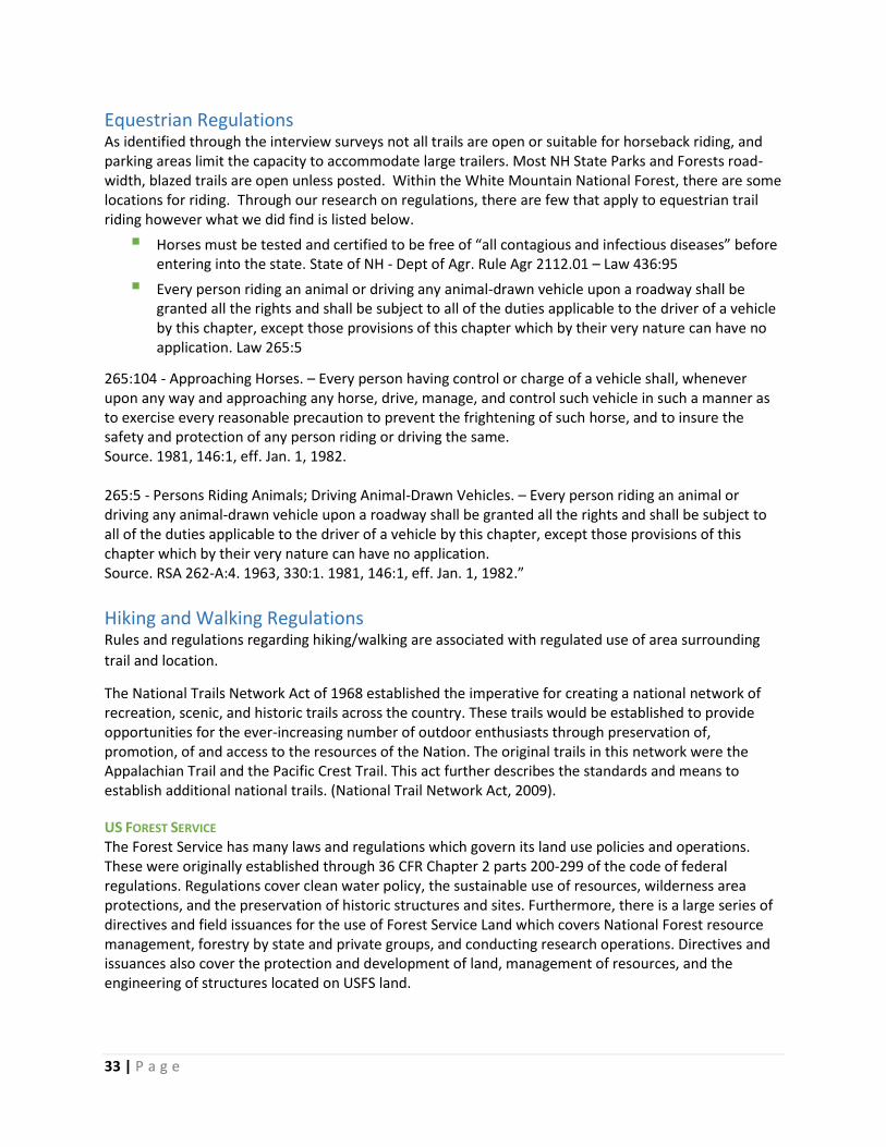
33 | P a g e
Equestrian Regulations As identified through the interview surveys not all trails are open or suitable for horseback riding, and parking areas limit the capacity to accommodate large trailers. Most NH State Parks and Forests road-width, blazed trails are open unless posted. Within the White Mountain National Forest, there are some locations for riding. Through our research on regulations, there are few that apply to equestrian trail riding however what we did find is listed below.
Horses must be tested and certified to be free of “all contagious and infectious diseases” before entering into the state. State of NH - Dept of Agr. Rule Agr 2112.01 – Law 436:95
Every person riding an animal or driving any animal-drawn vehicle upon a roadway shall be granted all the rights and shall be subject to all of the duties applicable to the driver of a vehicle by this chapter, except those provisions of this chapter which by their very nature can have no application. Law 265:5
265:104 - Approaching Horses. – Every person having control or charge of a vehicle shall, whenever upon any way and approaching any horse, drive, manage, and control such vehicle in such a manner as to exercise every reasonable precaution to prevent the frightening of such horse, and to insure the safety and protection of any person riding or driving the same. Source. 1981, 146:1, eff. Jan. 1, 1982. 265:5 - Persons Riding Animals; Driving Animal-Drawn Vehicles. – Every person riding an animal or driving any animal-drawn vehicle upon a roadway shall be granted all the rights and shall be subject to all of the duties applicable to the driver of a vehicle by this chapter, except those provisions of this chapter which by their very nature can have no application. Source. RSA 262-A:4. 1963, 330:1. 1981, 146:1, eff. Jan. 1, 1982.”
Hiking and Walking Regulations Rules and regulations regarding hiking/walking are associated with regulated use of area surrounding
trail and location.
The National Trails Network Act of 1968 established the imperative for creating a national network of recreation, scenic, and historic trails across the country. These trails would be established to provide opportunities for the ever-increasing number of outdoor enthusiasts through preservation of, promotion, of and access to the resources of the Nation. The original trails in this network were the Appalachian Trail and the Pacific Crest Trail. This act further describes the standards and means to establish additional national trails. (National Trail Network Act, 2009).
US FOREST SERVICE The Forest Service has many laws and regulations which govern its land use policies and operations. These were originally established through 36 CFR Chapter 2 parts 200-299 of the code of federal regulations. Regulations cover clean water policy, the sustainable use of resources, wilderness area protections, and the preservation of historic structures and sites. Furthermore, there is a large series of directives and field issuances for the use of Forest Service Land which covers National Forest resource management, forestry by state and private groups, and conducting research operations. Directives and issuances also cover the protection and development of land, management of resources, and the engineering of structures located on USFS land.

34 | P a g e
WILDERNESS REGULATIONS Motorized equipment and equipment used for mechanical transport is generally prohibited on all federal lands designated as wilderness. There are some exceptions to this rule and are specifically regulated. The following wilderness regulations are in effect for the following areas in Coos County. Not all regulations are in effect for every wilderness. Presidential Range-Dry River Wilderness (Wilderness.net)
Group size is limited to no more than 10 people per party.
Camping and campfires are prohibited within 200 feet of any trail and 1/4 mile of any hut, shelter, cabin, picnic area, or day use site (except at designated sites).
Overnight visitors cannot occupy any single location longer than 14 days in a 30-day period.
Do not store equipment, personal property, or supplies (caching) in the Wilderness (including geocaching and letterboxing).
As with all designated Wilderness areas, mechanical transportation (including wagons, game carts, and other vehicles) is prohibited.
Wild River Wilderness (Wilderness.net)
Group size is limited to no more than 10 people per party.
Camping and campfires are prohibited within 200 feet of Wild River Trail from Wild River Campground to 1 mile south. The Wilderness boundary begins at the .3 mile point of this restriction.
Camping and campfires are prohibited within 1/4 mile of any hut, shelter, cabin, picnic area, or day use site (except at designated sites).
Overnight visitors cannot occupy any single location longer than 14 days in a 30-day period.
Do not store equipment, personal property, or supplies (caching) in the Wilderness (including geocaching and letterboxing).
As with all designated Wilderness areas, mechanical transportation (including wagons, game carts, and other vehicles) is prohibited.
Great Gulf Wilderness (Wilderness.net)
Group size is limited to no more than 10 people per party.
Campfires (except liquid-fueled camp-stoves or candles) are prohibited.
Do not store equipment, personal property, or supplies (caching) in the Wilderness (including geocaching and letterboxing).
As with all designated Wilderness areas, mechanical transportation (including wagons, game carts, and other vehicles) is prohibited.
Overnight visitors cannot occupy any single location longer than 14 days in a 30-day period.
Camping is prohibited at the following locations (except at designated sites): o within 200 feet of any trail o within 1/4 mile of the Great Gulf trail, from the intersection of the Sphinx Trail to the
intersection with the Gulfside Trail o within 1/4 mile of any hut shelter, cabin, picnic area, or day use site

35 | P a g e
THRU-HIKING PERMITS AND REGULATIONS (APPALACHIAN TRAIL) There are no fees required to access the Appalachian Trail, however regulations, fees and permits are needed for specific areas within the AT. The Appalachian Trail Conservancy (ATC) has developed a list of permits and regulations in different areas along the trail including within White Mountain National Forest. There are no fees and permits needed to access the Appalachian Trail for walking, but many campsites along its route require a fee or have specific rules governing recreational use. This list of regulations can be found on the ATC’s website (Appalachian Trail Conservancy).
NH HIKE SAFE PROGRAM The New Hampshire Fish and Game Department established the “Hike Safe” program in 2015 through RSA 206:26-bb (New Hampshire Code). The Hike Safe Card absolves the cardholder of repayment of rescue costs if they need to be rescued due to negligence on their part, no matter the outdoor recreation activity. The cost of the card goes directly into the Search and Rescue fund to support these operations. (Hikesafe.com) Even with the card, a cardholder can still be found liable for costs if their actions were found to be reckless or intentional in creating an emergency. In 2015 there were approximately 2,800 Hike Safe cards purchased. There were 4,175 Hike Safe cards purchased during the 2016 season. The Hike Safe program was created as a source of revenue for the department, and a means to derive income from the increasing amounts of people attracted to New Hampshire by kayaking, hiking, back country skiing, and other sports. (David Brooks, 2016)
RAIL TRAILS Railroads have been subject to federal regulations since 1887, first by the Interstate Commerce Commission (ICC) and since 1996 by the Surface Transportation Board (STB). Rail trail development began in the late 1980s after Congress amended Section 8(d) of the National Trails Network Act in the 1980s to establish a program to allow rail corridors to be converted to trails in order to preserve vital rail infrastructure for possible future use. (Gee, 2016) Since that time, these statutes listed below have been established to further govern the abandonment, discontinuance, establishment and management of rail banks and their associated trails.
16 CFR 1247 – Allowed a railroad to divest itself of responsibility for an unneeded rail line by transferring it to a qualified private or public agency for interim use as a trail until such time as the line is needed again for rail service.
49 CFR 1152 – Establishes regulatory network for abandonment and discontinuance of rail lines and transportation
49 USC 10903 – Filing and procedure for application to abandon or discontinue
49 USC 10502 – Authority to exempt rail carrier transportation A general overview of how a railway is transitioned to a rail trail is listed below. This was written by the Rails-to-Trails Conservancy, an organization focused on protecting and expanding rail trails across the country. (Ferster, 2017)
1. An interested trail manager can request a railbanking order within 30 days after the railroad files an application for an abandonment with the STB.
There were approximately 4,175
Hikesafe cards purchased in 2016. This
brought in almost $105,000 to New
Hampshire Fish and Game to offset
search and rescue operations cost.

36 | P a g e
2. The STB will consider “late-filed” railbanking requests so long as it has jurisdiction to do so. The STB’s authority to railbank the corridor is terminated only after abandonment authorization is issued and the railroad notifies the STB that it has taken steps to consummate the abandonment.
3. Either a public agency or a qualified organization can submit a railbanking request to the STB. A statement of willingness to assume financial and legal responsibility must accompany the request, along with a map of the right-of-way and a filing fee set by the STB.21
4. If the railroad agrees to enter into negotiations with the trail manager, and no Offer of Financial Assistance to allow for continued freight rail service is submitted or accepted, the STB issues a Notice or Certificate of Interim Trail Use in lieu of an order authorizing the railroad to fully abandon the line.
5. If an agreement is reached for transfer of the corridor to the trail manager during the negotiating period, the corridor is added to the national “railbank” for so long as the trail use continues or until the corridor is needed for future restoration of rail service.
PADDLING AND BOATING REGULATIONS New Hampshire has a comprehensive set of rules and laws put forward in Title 22, Chapter 270 on boating and water recreation. This section describes the many different penalties, restrictions, enforcement, and destruction of equipment, operating boats, noise levels, and rafting. Furthermore, Chapter 270-D establishes the rules regarding boating and water safety. This section describes the general rules, boating guides, required safety checklists education and certification, and many other aspects of the boating network. There is also specific mention of boating and paddling in regards to alcohol or drug impairment in RSA 265-A. In New Hampshire you must have a Certificate of Registration and validation decals to operate a vessel on public waters. This includes motorboats of any size, and sailboats or sailboards 12 feet in length or longer. The only exceptions are:
Sailboats and sailboards under 12 feet in length
Other small, non-motorized vessels such as canoes and kayaks
Vessels registered in other states using New Hampshire waters for 30 or fewer consecutive days
Vessels owned or operated by the U.S. Government (Boat-ed.com)

37 | P a g e
The table below presents the important regulations regarding recreational boating safety put forward in the U.S. Code of Federal Regulations (CFR).
Description of Regulation Code of Federal Regulations
Penalties for Negligent operation & Interfering with Safe Operation
46 USC 2302
Numbering undocumented vessels 46 USC 123
Yacht Privileged and obligations 19 CFR 4.94
Operating a vessel while under the influence of alcohol or a dangerous drug
33 CFR 95
Regulated Navigation areas 33 CFR 165
Protection of Naval Vessels (Security zones) 33 CFR 165.2010
Vessel Numbering and Casualty and Accident Reporting
33 CFR 173
State Numbering and Casualty Reporting Networks 33 CFR 174
Carriage and use of Personal Flotation Devices (PFDs) 33 CFR 175.15
Carriage and use of visual distress signals (VDS) 33 CFR 175.101
Correction of especially hazardous conditions 33 CFR 177
Manufacturer certification 33 CFR 181.5-19
Identification of boats 33 CFR 181.21
Boats and Associated Equipment 33 CFR 183
Display of capacity information 33 CFR 183.21-27
Safe loading 33 CFR 183.31-43
Safe powering 33 CFR 183.51-53
Flotation Requirements for Boats 33 CFR 183.101-335
Electrical networks 33 CFR 183.401-460
Fuel networks 33 CFR 183.501-590
Ventilation 33 CFR 183.601-630
Start-in-gear protection 33 CFR 183.701-715
Navigation lights 33 CFR 183.801-810
Vessel identification network 33 CFR 187
Reporting undocumented vessel accidents and casualties
46 CFR 4.05
Carriage of fire extinguishing equipment 46 CFR 25
Backfire flame control 46 CFR 25.35
Source: U.S. Coast Guard Boating Safety Division

38 | P a g e
BIKING REGULATIONS On-Road Riding
New Hampshire law establishes that bicyclists have the same rights and duties as drivers of motor vehicles. The brochure “Don’t be a Road Warrior” was prepared by the Departments of Transportation and Safety, and the Highway Safety Agency to present detailed rules and cited regulations to help educate riders and drivers about bicycle safety and operation. The following rules are taken from that brochure:
Before entering the roadway, yield the right of way to approaching traffic. (RSA 265:32)
Stop and yield to cross traffic at a stop sign. (RSA 265:30-I)
Don't cross the stop line when the traffic signal is red. (RSA 265-30-I)
Stop for pedestrians in a crosswalk without traffic signals, and don't pass vehicles stopped at a crosswalk. (RSA 265:35-I&IV)
In preparing to turn left, do so from the farthest left lane available. (RSA 265:42) To prepare for the turn, first look behind and merge to the center line or left turn lane as traffic permits, signaling to get the cooperation of following drivers as necessary.
Don't ride on sidewalks (RSA 265:26-a)
Don't ride the wrong way on a one-way street (RSA 265:23)
Always wear a well-fitted bike helmet – it can save your life! (RSA 265:144) Special Rules for Bicycles
Persons riding bicycles two or more abreast shall not impede the normal and reasonable movement of traffic and, one-lane roadway, shall ride within a single lane. (RSA 265:144-1)
No bicycle shall be used to carry more persons at one time than the number for which it is designed and equipped. (RSA 265:144-2)
No person operating a bicycle shall hitch onto a car or any other vehicle moving upon a way. (RSA 265:144-3)
No person operating a bicycle shall carry any package, bundle or article which prevents the rider from keeping at least one hand on the handlebars. (RSA 265:144-4)
No bicycle shall be operated unless the steering, brakes, tires, and other required equipment are all in safe condition. (RSA 265:144-5)
Any bicyclist shall stop upon demand of a peace officer and permit his bicycle to be inspected. (RSA 265:144-6)
When bicycling after dark you must use a white front headlight and a red rear light or rear reflector. (RSA 266:86) (New Hampshire State Parks)
Biking is a rapidly growing recreational activity in Coos County and the North Country. Many clubs have appeared in the region that are focusing on redeveloping old trails and parks for mountain biking. Neighboring regions in Vermont have seen an explosion of popularity surrounding mountain biking trail networks and accommodations. We have presented an array of regulations, both official and unofficial which help to better understand mountain biking. Another growing activity on trails across the country is use of electric mountain bikes, or eMTBs. Regulations have started to appear on the federal level for different agencies governing the use of these bicycles.

39 | P a g e
There are many laws regarding on-road biking but few established rules for mountain biking. New Hampshire State Parks has presented some rules to follow while riding off-road. The golden rule established through the RSAs is to always wear a helmet. When possible, riders should ride with others to increase safety, and always carry identification. Riders should let someone know where they are riding and when they will return. Riders should also always carry some type of pack or bike bag with supplies such as fresh water, snacks, a flashlight, a bike tube repair kit, tire levers and an assortment of Band-Aids. Riders should ensure that the tail light and headlight are working properly before riding into the evening. Finally, riders should familiarize themselves with trail etiquette when traveling on multi-use trails. (New Hampshire State Parks) A New mode of recreational transportation is the electric mountain bike (or eMTB). An electric bike is defined as: “A two-or three-wheeled vehicle with fully operable pedals and an electric motor of less than 750 watts (1 h.p.), whose maximum speed on a paved level surface, when powered solely by such a motor while ridden by an operator who weighs 170 pounds, is less than 20 mph.’’ An eMTB is an e-bike that is capable of and primarily designed for off-road use. eMTBs typically have wider tires, a sturdier frame and may have front or dual suspension networks. New Hampshire has no explicit policy on eMTB use. It is thought that eMTBs are not mobility devices and thus would default to motor vehicle rules. There are currently no plans in NH to make rules for them at this time. They may resemble traditional bikes, but they are not the same. (International Mountain Bicycling Association)
How eMTBs are Currently Managed (International Mountain Bicycling Association)
Currently, eMTBs are not defined or dealt with consistently across land management agencies. EMTB access to trails and infrastructure depends on the authority with jurisdiction over the land.
NH Department of Natural & Cultural Resources and U.S. Forest Service and Bureau of Land Management (BLM) regulations categorize eMTBs as a “motorized” use. Therefore, eMTBs are only permitted where motorized vehicles are allowed.
Some state and local authorities manage eMTBs similarly to federal agency regulations. However, other agencies have decided to open non-motorized trails to eMTB use.
Several state parks, County open space organizations and municipalities treat electric bicycles identically to non-motorized bicycles, or have designated specific areas that are open to eBikes.
Many government entities have not yet considered the issue or have no policy regarding eMTB use at this time. (International Mountain Bicycling Association)

40 | P a g e
Unofficial Trail Rules and Etiquette While there may not be official regulations regarding some trail use, many come with their own rules of
etiquette. This section will present ethics, etiquette, and common sense rules that different user groups
have established to keep people safe on the trails.
Some trails have a variety of uses happening simultaneously. It is important to share the trail resources and be considerate of other users. The Bureau of Trails and NH Fish and Game work through the state associations and member clubs to ensure that user experiences are positive and ones which will be remembered for a long time. Backcountry Skier’s and Rider’s Code of Ethics (Wildsnow.com)
1. If I choose to access the backcountry by mechanized means, I will do so in a respectful fashion,
obeying all rules and regulations, and driving with care when around foot travelers such as
snowshoers, snowboarders and skiers.
2. If I access the backcountry my motorized means, I will do so respectfully, taking care when
around foot traffic such as snowshoers, snowboarders, and skiers.
3. I will respect designated areas, trail use signs, and established ski tracks. When traveling on foot
or snowshoe, I will not damage existing ski trails that backcountry skiers have created and are
using.
4. When stopping, I will not block the trail.
5. I will not disturb wildlife and will avoid areas posted for their protection or feeding.
6. I will not litter, and I will pack out everything I packed in, including pet results.
7. I will adjust my backcountry skiing or riding pace and level of risk to that which my whole party
is comfortable with.
8. I will not encourage or push others to take risks they are not comfortable with.
9. I realize that my destination and travel speed are determined by my equipment, ability, terrain,
weather, and traffic on the trail, and will plan accordingly.
10. In case of an emergency, I will volunteer assistance. I will always carry basic emergency
equipment such as a light source, shovel, and first aid supplies.
11. I will not interfere with or harass other recreationists involved in legal/normal activities. I
recognize that people judge all other winter recreationists by my actions.
12. I will promote a friendly and positive attitude while in the backcountry. I will smile and greet
others on the trail, offer information about conditions, and offer assistance if necessary.
Backcountry Camping Rules (https://www.fs.usda.gov/Internet/FSE_DOCUMENTS/stelprdb5363715.pdf ) Leave No Trace: No amount of regulation will preserve the backcountry unless each of us makes a personal effort to lessen our impact. Always plan your trip well enough in advance to be prepared for whatever you might encounter and learn to be a “no-trace” hiker.
Leave what you Find: Plants, animals, and cultural sites and artifacts should all be left for the next person to enjoy.

41 | P a g e
Minimize Campfire Impacts: Use a lightweight backpacking stove. In some places campfires are prohibited, but stoves help minimize the impact everywhere.
Respect Wildlife: Don’t feed, chase, or harass wildlife and be sure to hang your food well out of reach of bears.
Be Considerate of Others: Think about how your actions affect other people. Loud noises, out of control pets, cell phones, and radios are a few examples of what might bother other hikers.
Plan Ahead and Prepare: Find out about the area you will be visiting, including any regulations or restrictions. Be sure to have maps, proper clothing, equipment, food, and water. Keep your group size to 10 or less (this is required in Wilderness and recommended everywhere).
Travel and Camp on Durable Surfaces: Stay on the trail while hiking. Camp at sites that have already been heavily impacted (but be sure it’s a legal site), or 200 feet from trails and water sources. Avoid moderately impacted sites where your visit could create more damage.
Dispose of Waste Properly: Carry out what you carry in; bury human waste in a hole 4-8 inches deep, away from water, trails, and campsites.
HikeSafe Hiker Responsibility Code (Appalachian Mountain club)
You are responsible for yourself, so be prepared:
With knowledge and gear. Become self-reliant by learning about the terrain, conditions, local weather and your equipment before you start.
To leave your plans. Tell someone where you are going, the trails you are hiking, when you will return and your emergency plans.
To stay together. When you start as a group, hike as a group, end as a group. Pace your hike to the slowest person.
To turn back. Weather changes quickly in the mountains. Fatigue and unexpected conditions can also affect your hike. Know your limitations and when to postpone your hike. The mountains will be there another day.
For emergencies. Even if you are headed out for just an hour, an injury, severe weather or a wrong turn could become life threatening. Don’t assume you will be rescued; know how to rescue yourself.
To share the hiker code with others.
The Hiker Responsibility Code was developed and is endorsed by the White Mountain National Forest and New Hampshire Fish and Game.
Agencies and nonprofits involved in search and rescue in the White Mountains are supported by the New Hampshire Outdoor Council

42 | P a g e
Interview Data North Country Council staff began identifying stakeholders to interview in the Fall of 2016. Stakeholders included clubs, conservation organizations, local advocacy groups, state agency officials spanning a wide range of disciplines, and known individuals active in trail-related activities. A list of approximately 150 stakeholders and their contact information was compiled. Outreach efforts were made via email and telephone to all stakeholders to introduce the project and to schedule an interview. Follow-ups were made both via email and phone to those who did not respond. Fifty-six stakeholders were interviewed out of the original 150 identified (we note that only 46 interviews were entered into the analytical survey tool as a result of 10 interviews did not have enough data relevant to trails). Those who were interviewed not only came from different types of organizations but spanned a large variety of trail use type as well. After conducting interview the data was then entered into the analytical survey tool “Survey Monkey” for organization, quantification, and analysis. The survey grouped the stakeholders into specific purpose categories.
Advocacy
Safety
Activity-Based Club
Government (Federal, County, State, Municipal)
Landowners
Steward
Advocacy/Steward
Business As shown below, the largest 3 groups interviewed were Activity-Based Club, Advocacy/Steward and Government entities.
Figure 7 North Country Council 2017 Survey Interviews
28%
17%
17%
13%
11%
7%
4%
2%
0% 5% 10% 15% 20% 25% 30%
ACTIVITY-BASED CLUB
ADVOCACY/STEWARD
GOVERNMENT
BUSINESS
STEWARD
ADVOCACY
LANDOWNER
SAFETY
Primary Purpose of Organization Relative to Trail Use
43 | P a g e
Participants were asked a series of questions regarding various aspects of the Coos County Trail Network. These questions focused on:
Needed Improvements
Essential Qualities of the Network
Safety Issues
A Comprehensive On-Line Trail Map
Overuse Issues
Benefits & Downsides to Multi-Use Trails
Impacts on Natural Resources
Factors Resulting in a Positive Trail Experience
Community Impact
Interviewees represented a variety of trail uses the majority of stakeholders interviewed considered
themselves to be representative of multi-use groups, followed by OHRV and snowmobile users, while
the remainder were relatively equal in representation.
Figure 8 North Country Council 2017 Survey Interviews
43%
15%11%
7% 7% 4% 4% 4% 2% 2%
Trail Activity Represented

44
Please tell us all the ways your organization/business is directly involved with trails in Coos County.
The majority of stakeholders interviewed were directly involved with trails through construction, management, maintenance or contact with user groups. The survey results emphasized the significant importance of volunteers to the maintenance and oversight of the many trails networks. As a result, we note that volunteers are heavily relied upon in relation to being directly involved with trail activities. These activities represent maintenance, construction, management and education as paid staff. One issue identified during the interview process is the aging out of current trails volunteers and the lack of new and younger volunteers to continue the work of these trail systems. This challenge spanned a wide array of uses and clubs. As volunteers age, it becomes more difficult to assist in labor-intensive
Figure 10 North Country Council 2017 Survey Interviews
70%
63%
59%
43%
17%
17%
15%
15%
11%
9%
0% 10% 20% 30% 40% 50% 60% 70% 80%
Maintain
Manage
User Group
Construct trails
Own the trail rights
Own the land or road over which the trails pass
Land Use Policy
Business Dependence
Emergency Response
Law Enforcement
Figure 9 North Country Council 2017 Survey Interviews
59%
70%
37%
26%
0% 10% 20% 30% 40% 50% 60% 70% 80%
Does your organization employ paid staff directlyinvolved with the trails?
Does your organization have volunteers directlyinvolved with the trails?
NO YES

45
trail building and maintenance activities. This is compounded by the lack of new members and younger members coming in to fill that need. To maintain and improve the trail networks throughout Coos County, it will be important to bring in new members to support ongoing trail building, maintenance, and stewardship of the trail network. When interviewees were asked the question: are the trails multi-use? 87% responded with yes.
However, when we investigated further, we note that 33% allow both non-motorized and motorized activity to coexist on the same trail, with 43% being only non-motorized use and 25% motorized use.
From this, it is seen that there is a separation between motorized and non-motorized use and a need to define “multi-use.”
In the future, better delineation of the definition of “multi-use” may be necessary to obtain a full understanding of how these trails networks are utilized.
Figure 11 North Country Council 2017 Survey Interviews
87%
13%
33%
43%
25%
Are Trails Multi-Use?
Are Trails Multi-Use? Answered Yes

46
Interviewees were asked if trails are mapped and what format are the maps in. A surprising finding was a majority of the County’s trails are mapped or exist on paper and in the virtual world in a variety of forms from PDF to interactive GIS. Organizations that had maps available commented that they updated them on a regular basis from yearly to every four years.
During the interview process, stakeholders were asked: If a comprehensive County-wide on-line trail
map were developed in the future, do you think your group would consider being a part of it? 60% of
those interviewed indicated they would consider being a part of a comprehensive County-wide online
trail map. In doing so, they think this map would assist users in having greater access to the trails, create
awareness, and promote the trail network.
While at the same time, 40% indicated that they would not participate. Those that responded negatively indicated reasons being: maps are for a specific use (emergency response), they lack the capacity to participate, and lack sufficient alternative funding sources.
Deeper discussion with those who indicated they would not participate in a comprehensive online map revealed that maps are a much-needed source of revenue to assist in maintaining trails. They expressed concerns that a comprehensive map would limit their ability to capture these funds.
60%
40%
Online Trails Map
Yes No
Figure 12 North Country Council 2017 Survey Interviews

47
Stakeholders were asked if improvements or changes are needed within the trails they are involved
with. While an overwhelming majority answered yes to this question, interviewees were also asked to
elaborate on their answer.
Increased & new club membership
Trail networks are highly dependent on volunteers for various activities, and there is a need to cultivate and grow these relationships including reaching a younger population to continue this work into the future.
Funding and support
Increased funding solutions are needed to solve grant matching challenges and an overall need for increased support.
Maintenance
Ongoing and routine maintenance including trail brushing, grading, water maintenance and drainage work are a constant need.
Signage
Marking of trails, to include allowable use along with the need of uniformity between networks is a much-needed improvement.
Standardization
Standardization of signs, repairs, design, new construction, infrastructure, and maintenance practices are needed across the County’s many networks.
Education
Increase awareness of and education about the rules, regulations, trail uses, and etiquette in the County.
Access (parking, services, amenities)
Improve access to existing and future trail networks, amenities and services through better parking capacity, location, study of demand, and infrastructure improvements.
Enforcement
Increase enforcement of regulations and rules specifically in regards to speed and age of driver. Also, consistency of on-road use.

48
We asked stakeholders: What features or qualities are essential to have in this trail network? The majority of the responses directly linked to other responses heard throughout the interviews.
Having suitable access to parking and access to amenities and related services.
Scenic areas, vistas or overlooks for viewing of wildlife, the ability to experience a variety of forest types and habitats.
Mutual agreements between neighboring states in relation to OHRV use, appropriate aged for motorized trail users, standardization, safety equipment and trail registration.
The need to continue to foster and grow current and new relationships with landowners.
Varied level of difficulty and terrain variations for all abilities.
Proper design to include sustainability, standards and proper process for building trails.
Well maintained trails lead to a better experience.
It is important that trails access a variety of landscapes; allowing users to experience new areas. Trails need to be well maintained to keep them safe and accessible for users. Proper signage is key to positive experiences to ensure that users do not get lost, put in harm’s way or misinterpret intended use. Safety is paramount to the clubs and users in the region, as an unsafe trail can lead to injuries and accidents and damage to equipment. Respondents furthermore spoke about the importance to tranquility and getting that wilderness or backcountry feel when out on the trails.
QUALITY OF THE EXPERIENCE
Maintenance
Proper Design
Ability Levels
Landowners
Signage
Support
Connectivity
Regulations
Scenic
Services
Access
Safety is paramount to the clubs and
users in the region, as an unsafe trail
can lead to injuries and accidents and
damage to equipment.

49
Are you aware of any safety issues?
Half of those who participated in the survey process indicated that they were aware of safety issues.
Many of these concerns were echoed throughout the interview and included speed, operator age, and
ill-prepared trail users.
Unprepared - lack of information, poorly equiped, unaware of area, unfamiliar with conditions, not equipped for weather.
Lack of Communication - cell phone coverage has gaps, signs are in poor condition or lacking uniformity between networks is relatively non-existance.
Bridges - slippery, some are in need of repair and not appropriate for all types of trail uses.
Patrol - enforcement of rules and safety.
Regulations - age of motorized operators.
Design - areas in need of better design and maintenance.
Speed - increased enforcement of motorized speed.

50
We asked interview participants: Are you aware of any problems related to overuse of the trails? 64% responded “No” while 31% answered “Yes.” When asked to expand upon their answer, respondents reported that overuse is not yet a significant issue. However, there are isolated areas of concern on highly traveled areas. Interviewees indicated that they were concerned about the potential impact with expanded future use.
Parking and access - Current locations which are not adequately built-out have occurrences of illegal trail head parking or roadside parking. This causes unclear access leading to improper use.
Concerns regarding future use and increased use - Related to water pollution, the health of the network, sensitive areas (especially alpine areas and wetlands), habitat destruction, trail erosion, noise, dust and human-wildlife interactions.
Maintenance and Proper Design - Needed to maintain the quality of experience for trail users, lessen environmental impacts, and effectively build-out future trail.
Maintenance - Ongoing maintenance vital to mitigate trail widening, erosion, grading changes.
Increased Use Areas - A need for greater enforcement and monitoring of activities to lessen impacts and ensure proper use.
We asked interview participants what benefits do you see to these trails being multi-use?
Out of the 46 recorded stakeholder interviews, 86% identified themselves being involved with trail activity of multi-use. Out of this, there was an identified 33% which represented an overlap of non-motorized and motorized use, with 43% representing multi-use only within non-motorized users.
WHEN ASKED TO ELABORATE
Allow a wider range of people access to the outdoors and trail experience.
Help trail funds spread farther by opening up grant opportunities and volunteers to work on trails.
Open up trails to four-season recreation for outdoor enthusiasts.
Establish partnerships that develop a sense of community between user groups.
Create increased prosperity in wages, revenues, and business activity through diversified trail uses and visitors.

51
Do you see any downsides to these trails being multi-use?
The responses to this question focused on user conflicts such as interactions between bikes and horses, landowners and users, bikers and hikers, and non-motorized and motorized uses.
There was also a lack of understanding and need for respect between user groups. Also, it was reported that maintenance is a concern for multi-use trails and that not all groups contribute to the cost of maintenance of shared trails. There was one comment where the perception of the stakeholder took into the consideration the loss of traditional and historic trail experiences when considering the downsides to a multi-use trail.

52
North Country Council staff asked stakeholders: Are you aware of any negative impacts of the trails on
natural resources? Almost 70% responded no. When asked to elaborate, we learned that there are
isolated areas of impact. However, the highlight was the concern for potential impacts associated with
future increased use.
Off Trail Activity
Establishment of informal campsites.
Widening of trail due to avoidance of muddy or wet areas, improper maintenance or construction, and high activity.
Trampling of sensitive species and habitats especially a concern at high altitudes.
Altering of Wildlife Behavior
Disruption of bird nesting habitat.
Learned behavior (bears associating people with food).
Disruption of wildlife movement due to human noise and presence.
Introduction of pathogens into water networks and wildlife as a result of improper disposal of human waste.
Spread of Invasive Plants
Changing of the natural plant community, scenery and impact wildlife food sources.
Near the end of the interviews, we asked a series of questions regarding how stakeholders thought the presence of trails affected communities and what factors impact whether or not the trails provide users with a positive experience.
The majority of respondents considered the presence of these trails impact communities in a positive manner providing an economic driver. It was reported that increased trail use in the County has led to increased home purchases, increased patronage of restaurants, outfitters and rental shops, and boosted numbers of stays at hotels and campgrounds.
A few stakeholders commented on isolated areas of negative impact mostly associated with inadequate parking and motorized use in unideal locations.
Overall, participants felt that creating a successful trail network requires finding the right balance between respect for the environment, other users, landowners, rules and regulations.
The top two factors that stood out as to effecting whether or not users had a positive trail experience were the overall trail conditions and available information. Other factors often mentioned were: scenic views, access to services, courtesy of others, trails with varied ability levels, parking access, and interconnected networks. Also, several individuals mentioned safety, security, and local hospitality.

53
CONNECTIVITY Connectivity was a major talking point throughout the survey process. Respondents spoke about the importance of trail to trail connectivity, trail to service connectivity and trail to community connectivity. There was further noticed a trend in connections between communities and organizations which also support trail networks throughout the County. One of the most common things noted throughout the process was the importance of landowners in keeping trail connections and the wider system open. Landowners can have a massive impact on trails if they are displeased by users actions or the effects of trail use on their property. Many landowners are reticent to open their land to users, and it is important to listen to their concerns and support them however possible. To this end, it is vital to ensure their cooperation and approval of using the trails because, without the landowners, there would be no system. The trail to trail connectivity was identified as important for a number of reasons. The trail to trail connectivity is important because it allows visitors and residents to access new communities and landscapes via supported, serviced routes. Clubs have been building and maintaining new connections between their trails and those of other clubs. Furthermore, there are many connections being made between Coos County trail networks to established trail networks in Maine and Vermont which can attract new visitors and create collective impact through cross-network visitors. Trail to service connectivity was also identified as a major factor in the economic health of the region. Trails connected to services created collective economic impact, allowing people to access services along their whole route. Motorized riders require access to gas, convenience stores, and other retail to help support their rides. Access to a network of services is important to help riders enjoy the trail systems. Growing numbers of non-motorized users on the trails also have a high potential for connected businesses. Connected services help to facilitate the trails industry; as services such as retail,
fuel, food, and lodging accommodate further use over a longer time span. Trails linked to parking and adequate access points are also able to effectively handle greater traffic of both motorized and non-motorized user. An ongoing effort has been made to increase cellular connectivity in the more remote areas of the County, improving search and rescue operations and the ability for trail users to navigate. There are many connections made from communities to organizations which have facilitated and expanded trail networks. Conservancy groups have formed
partnerships with regional paddling trail groups to expand facilities while maintaining ecosystem sustainability. The federal and state governments work with local clubs and towns to better plan and design trail routes to lessen environmental impacts. Clubs also partner with towns to create multi-use trails and other facilities. These connections between groups have significant impacts in opening up new trails, maintaining current trails, and getting the word out to their existence.
The major allure is connectivity. Connected
trails create a powerful incentive to visit.
These trails also create collective impact,
as many trails and communities are linked
together into a larger network.
Growing numbers of users on
interconnected trails also has a high
potential for nearby business success.
Connected services help to facilitate the
trails industry; as services such as retail,
fuel, food, and lodging accommodate
further use over a longer time span.

54
Working Group North Country Council conducted a series of eight working group sessions from November 2017 to March 2018. These sessions and their discussions helped to create the structure of the vision, guiding principles, and framework of a future Comprehensive Coos County Trails Plan. Also, these sessions assisted in confirming identified concerns and priorities. This working group will provide a foundation for future Coos County trail discussions by bringing together stakeholders in a collaborative environment. The information gained through these sessions provided valuable and positive contributions to future development. The working group contact list is made up of a diverse array of stakeholders. This group was compiled by using a short set of criteria. First, they responded to and were interviewed during the survey phase. Second, that individual or organization attended the public meeting presenting our preliminary report findings. Third, we identified stakeholders who were particularly active in their specific user groups and those who were connected to other regional groups. These criteria helped to identify stakeholders who were active in their sport, engaged with their user groups, and showed a clear interest in being involved in sessions with other groups. The working group contact list is kept up-to-date to ensure session information is properly relayed to groups across the County due to many members not being able to attend every meeting.
24%
19%
19%
10%
10%
10%
10%
0% 5% 10% 15% 20% 25%
ACTIVITY-BASED CLUB
BUSINESS
ADVOCACY/STEWARD
STEWARD
SAFETY
LANDOWNER
ADVOCACY
Working Group Members by Primary Purpose Related to Trail Use
Figure 13 North Country Council Trails Working Group

55
Summary of Discussions The working group sessions had a variety of conversations regarding the trail project. The initial session focused mainly on the possible benefits of a trails plan and discussion on issues such as compatibility, design, and revenue supporting trails. Further sessions were spent discussing the structure of a plan and what a scope of work can accomplish, along with drafting up tables of content to discuss. After the initial drafting of tables of content, the working group discussed adding different items to the plan including an asset inventory, a public engagement process, and best management practices. Throughout the working group sessions it was highlighted that landowner buy-in is vital to any future work, be it mapping, collaboration, signage updates, or other developments. The idea of a mapping inventory was presented and how it could best serve the clubs, members, and users.
North Country Council staff attended the February monthly search and rescue working group meeting at the Pinkham Notch Visitor’s Center. North Country Council staff engaged these stakeholders on the issues and opportunities facing the search and rescue community. Questions were asked about current capabilities, cooperation, and future areas of growth or concern as trail use evolves in the region.
52%
14%10% 5% 5% 5% 5% 5%
0%
10%
20%
30%
40%
50%
60%
Working Group Members - Trail Activity Represented
Figure 14 North Country Council Trails Working Group

56
It is planned that these working group sessions and their attendees will help to form the foundation of a longer-term engagement process and a regular group of individuals who can collaborate on the implementation of a Coos County Trails Plan. It was highlighted by many working group members to make the Trails Plan a useable document, able to quickly point the reader in the right direction to answer a question and provide valuable information for trails groups.
Development of Vision and Guiding Principles VISION The Coos County Trails network will be:
“A network of trails for all uses and abilities that
sustainably contributes to the quality of life and
prosperity of the County by enhancing recreational,
educational, and economic opportunities for all.”
GUIDING PRINCIPLES The Coos County Trail network is established around:
Diversity – Work to accommodate all user groups in a safe and respectful manner.
Accessibility – Create a trail network accessible to users of all abilities and skill levels.
Sustainability – Commit to developing a network that is sustainable from the community, environmental, economic, financial, and design perspectives.
Inclusiveness – Commit to positive public
engagement around future developments by
understanding the importance of the trail network for
community members, businesses, and visitors.
These sessions helped to make concrete
many of the concepts brought about
through the interview process and brought
forward the possible means to developing a
sustainable future for Coos County Trails
network.
Table of Contents
Executive Summary
Background
Introduction
Vision
Guiding Principles
Planning Process
Plan Overview
Public Involvement
Engagement Strategy
Findings
Existing Conditions
Land use
Natural Environment
Organizations
Trail Network
Overview
Analysis
Recommendations
Implementation Action Items
Resources
Design Guidelines
Support Organizations
Funding Opportunities

57
Identified Priority Needs, Issues & Concerns The needs, issues, and concerns represent some of the most talked about, long-standing, and detrimental issues to positive and expanding trail use. It will be vital to address these issues in the data collection and analysis phase to ensure the trails in Coos County are accessible, safe, well connected and promote an active outdoor lifestyle. Information learned through stakeholder interviews, roundtable discussions, the review of prior reports, and discussions with the working group was developed into the following content.
Mapping – There is a consensus that a centralized online
depository for maps would be important and fill a major
role. These maps would need to be produced with the
consent of the landowner, provide an accurate
description of trail uses, the level of activity, and location.
Maps are often a main source of revenue to many
organizations and finding an alternative funding source
to replace this revenue will be needed in the case of any
changes to the current network. Maps are being created
through outside groups and in many cases are available
for free via the web. However, in some cases, permission has not been given to publish this information,
and it does not properly reflect the location and condition of the trail.
Increased Volunteerism – The age of volunteers is increasing, and the numbers of volunteers have been
decreasing as is also seen in many other aspects of the community or civic service. The concern and
need to increase club membership and volunteers was pointed out across all trail user groups involved
in all aspects of trail activities.
Funding – The majority of respondents spoke on the need for increased or enhanced funding. This stems
from the need for greater funding across the board for trail support, the need for new forms of funding
support, and the ability to pool resources for collaborative projects.
Design and Maintenance – There is a need for continued maintenance. Funds and volunteers need to be
available in order to meet the demand for maintenance tasks throughout the year. Develop an
accessible, comprehensive list of best practices for design, construction, and maintenance. Many user
groups and agencies have developed best practices, and it would help to aggregate them in one central
location for all to access.
Signage – The County trail network is unique because
of the patchwork of different trail ownership and
responsible trail groups active in the region. Each of
these groups has unique trail signs and character they
bring to their networks. There is a need to create some uniformity throughout the network. This may
come in the form of consistent placement and guidelines at trail entry points allowing for increased
awareness and create better experiences on the trail.
It is important to think about providing
greater opportunities for regional
promotion, awareness and education.
There is significant concern from trail
club managers that a comprehensive
trail map available online would
impact the clubs revenue. Many
clubs depend on the revenue from
not only map sales but from
sponsorship/advertising associated
with the maps.

58
Education & Awareness – Increased awareness of rules, regulations, trail uses, and etiquette is a major
need. Focus on increased education on User preparedness, knowledge of the area, active trail uses, and
interacting with other users.
Connectivity – Boosting connectivity between trails and services including food, lodging, and fuel is a concern for many users. Landowners – Continuing to foster and grow relationships with landowners is essential to the existence of the network. Compatible Use – There is a need to identify compatible uses and to define multi-use. Trail Network Conflicts – Utilize early engagement with users, businesses, local officials, and residents to mitigate and minimize conflicts. Trails are part of the heritage of Coos County. They have been used for industry, recreation, and conservation. Many people have seen a great change in the fortunes of the county with the increasing trail use by residents and visitors to the region. This increasing use has caused many to see it as a reinvention for Coos County, with positive economic, social, and community impacts. This report of findings was assembled to compile the wide array of trails research and information at hand, analyze the data gathered through surveys with county-wide trail groups, catalog some of the regulations governing trails, and present the discussions had during the working group sessions. This work will act as the foundation of a future trails plan by bringing together the many stakeholders, research, and regulations which work on and inform the activities of the trails. The following section is a result of the information gathered and is laid out as recommendations to guide future development of the Coos County Trails Network. These recommendations are developed to be vetted through public participation adjusted where and when needed and lastly actionable over time.

59
Summary of Recommendations
Planning Framework
&
Scope of Work
For
Comprehensive Coos County Trails Plan
Prepared by:
North Country Council
May 2018

60

61
Summary
The trail network of Coos County is multifaceted involving communities, landowners, management
organizations, and multiple types of use. This network is a growing opportunity as Coos County
reinvents itself in the 21st century. There have been a number of New Hampshire Trail Studies published
all offering recommendations and identity to the assets and challenges of a state wide trail network
dating back to 1974. During the 1974 study, it was recommended that elements of the system should
be designated, acquired, developed, and maintained in accordance with a plan for each area which
would minimize environmental impact and conflicting trail use. The 1974 study set out to address future
trail needs and develop a planning framework. In the 1997 Statewide Comprehensive Trails Study
recognized that at that time there were “increasing demands on all trails.” Although these plans are not
County specific, they echo many of the same concerns that were heard throughout this project
regarding increased and new use, safety and user conflicts, over forty years later.
Source: 1974 Trails Study
Recommendations
The recommendations laid out here are the foundation
of expanding and sustaining the Coos County Trail
Network to better all those living in and visiting Coos
County. Priorities will have to be established as to the
timing and stages of implementation. Facets such as
the economic impact assessments will need to be
planned to collect accurate data to be utilized during
implementation. Strategies to boost volunteerism and
diversify funding resources are important and need to
be thoroughly discussed at all levels of development
regarding the trail network. The key components will
be the utilization of the: Planning Framework,
Engagement, Conflict and Carrying Capacity Processes
described below to help bring Coos County Trail
Network discussions from planning to action.
It is recommended that during
the next step of this project the
working group be reconvened to
revisit materials presented as a
result of this project (step one)
and that a public roundtable be
held to kick off the next step to
establish public buy-in.

62
Planning Framework The planning framework was developed through analysis of compiled research, working group discussions, vision and guiding principles for the trails network. These components will guide the various stages of work forming a Coos County Comprehensive Trails Plan and direction of future development. These guiding components will be revisited by the working group at the center of the planning framework to be given final input and approval before moving forward. It will be important to develop and maintain a stable membership of the working group as this process will extend over a long period. It is recommended to develop a planning framework to be a tool to coordinate, guide, and inform trail network developments. The framework as illustrated on the following page is an ongoing and continuing process with the working group and technical specialist at the center. This framework involves the following:
Education and Outreach
Implementation and Development
Monitoring
Assessment
Updates to the plan Public participation is a major component throughout the planning framework. Each step of the framework will be highlighted with open dialogue, engagement early and often, use of local technical experts, and working group to give active commentary on the work being completed. Cost Estimate - The planning framework will be utilized during the implementation of identified projects
and future development. Implementation of the framework would be inclusive of future work. However,
the framework developed here as a recommendation before being applied to work should be
thoroughly vetted through public input. The cost for such vetting is estimated to be $5,000 and cover a
series of public meetings throughout Coos County on varying levels.
For the purpose of this work a trail is
to be considered – a designated route
on land or water with public access for
recreation or transportation purposes
including: walking, jogging, hiking,
OHRVing, horseback riding, mountain
biking, paddling, hiking, mushing,
snowmobiling.

63
Education & Outreach
Implementation & Development
MonitoringAssessment
Update
Working Group Technical
Specialists
COOS COUNTY COMPREHENSIVE TRAILS PLANNING FRAMEWORK

64
Engagement Process The trails throughout Coos County vary in size, location, purpose, and geography. Due to this diversity, it is necessary for future development to occur in a collaborative and inclusive manner. It is vital to include community members, residents, clubs, municipalities, landowners, business owners, trail users, trail stewards, governmental agencies and everyone in between to allow their opinions to be heard. The chances significantly increase that future development efforts will stall or sit dormant if this process is not inclusive. The engagement process will lay the foundation for developing a collaborative and sustainable network that remains “world class” as identified in the 2014 Regional Plan for the North Country. This process will work to allow stakeholders to stay informed, consulted, involved, collaborated with, and empowered. The planning group should be built on a diversity of perspectives. Planning efforts should allow for development to be publically vetted and supported by stakeholders. It is recommended to:
Engage with stakeholders early and often throughout all development
Involve an engagement specialist when deemed necessary
Create a central website to post development information including schedules, meetings, and draft recommendations
Draft and release quarterly reports on progress to keep the community-at-large up-to-date
Hold regularly scheduled meetings of the stakeholder working group to maintain involvement, and ensure the process is on a proper trajectory
Hold public meetings after process milestones to present the work thus-far and gather wider public input
It is important to revisit, re-engage, and extend an invitation to old and new working group members as the Comprehensive Trails Plan and development of Coos County Trails Network moves from these preliminary data gathering and foundation building stages to developing the actual plan. During the working group process, code of conduct was agreed upon. It is recommended that this continue to allow for a safe space for positive collaboration and contributions.
Inclusive and early engagement is important to creating a positive outcome for the development of the Comprehensive Coos County Trails Plan.

65
Involving the public in the planning process will enable the working group in the center of the planning framework to:
Learn about public concerns, issues, expectations, and values
Educate people about the process, issues, and proposed solutions
Learn about the values placed by others and groups on shared resources and visitor experiences
Build support for implementing the plan and future development among the public, visitors, public officials, and other stakeholders
The planning group will be engaging stakeholders throughout the planning process. It will be important for the planning group to assure stakeholders that the planning process is reasonable and fair and that public concerns are being listened to and taken into consideration. Cost Estimate - This recommendation does not have a cost estimate attached. It is recommended that a consultant or organization oversee the facilitation of the engagement events. This is estimated to cost $75.000 to $200.00 per hour.
Addressing Conflict North Country Council staff has recognized that there is a significant amount of information on this topic and that there are no simple solutions. Trail conflict can take shape in many forms and exists on and within different trails and their nearby communities. Traditionally there has been a divide between motorized and non-motorized users, but it is also important to note that many other trail conflicts can take shape in many forms including:
Among or between trail users
Between trail users and other recreationist
Between trail users and property owners
Within a trail use activity
With non-recreational land uses (ex: forestry activities) The increased accessibility, changing social norms, and advances in the technology of recreation gear have contributed to a growth in the number of trail users. Contact is not always a cause for conflict despite increasing numbers of users. It was found that users, communities, and property owners for the large majority are mostly satisfied with their experience on and with trails through this research. However, it is also recognized that conflicts do exist and have a varying degree of consequences and severity. These conflicts all present different challenges for trail managers that require thoughtful resolution.
Early, often and responsive
engagement is key to providing
positive solutions to conflict.

66
The key to successful conflict resolution lies in a problem-solving approach facilitated by a neutral party. This facilitator can be a consultant or an organization brought into the conflict. This approach uses cooperation and early engagement as its cornerstone and focuses on finding agreeable solutions for all parties. It encourages collaboration rather than competition. It is important to understand the background and context of a
conflict to create a successful facilitation scenario. The overall process will largely depend on the conflict, the degree of conflict, and the group(s) at hand. The setting for conflict resolution may be through open discussion or a structured process. It is recommended to include the following in the process:
Classify and acknowledge the type of conflict
Adopt problem-solving approach that encourages and incorporates early engagement rather
than competition
Respect the interests and needs of all parties involved
Establish clear lines of communication to keep stakeholders involved and invested in conflict
resolution
That there be multiple methods which can be applied depending on the type of conflict including:
Improved trail design
Increased and effective education for users
Increased marketing of information to visitors and residents
Engagement with stakeholders including landowners, residents, users, and trail groups
Enforcement of effective regulations There are many positive outcomes from addressing conflicts through a problem-solving approach. Conflict resolution should help to maintain and improve user safety, protect natural resources, respect the communities that trails lie within, and respect the land the trails lie on. Furthermore, it is recommended that conflict resolution should strive to utilize a strategy that encourages cooperation rather than competition, leading to a middle ground where all involved can agree. Cost Estimate - This recommendation does not have a cost estimate attached it is recommended that a consultant or organization oversee the facilitation of the engagement events. This is estimated to cost $75.000 to $200.00 per hour.
Addressing Carrying Capacity Carrying capacity is an issue discussed at length in outdoor recreation management. Recreational carrying capacity is defined as the level of use an area can withstand while providing a sustained quality of recreation for visitors. This concept was originally applied to the wider environment but was expanded in the 1960s to discuss the effects on visitation and experience, not just biological and ecological effects. Efforts to define carrying capacity and apply it to trails systems have often led to challenges. The question at the center of the discussion is how much resource or social impact is acceptable to a given
Not all parties can be
completely satisfied but
the goal will be to create
compromise to move
forward.

67
area? This question is known as the Limits of Acceptable Change, or LAC, and is central to the discussion of carrying capacity and its management solutions. Certain elements are shared between the many frameworks while still having different focus areas and indicators to suite individual organizational missions, policies, and procedures. Some of the well-known carrying capacity frameworks are:
Visitor Impact Management (VIM) from the National Parks and Conservation Association
Visitor Activity Management Process (VAMP), from Parks Canada
Visitor Experience and Resource Protection (VERP) from the Forest Service It is recommended that a carrying capacity analysis process that incorporates the following components be utilized in the Coos County Trails network and future development.
Identify the key features that affect trail use
Location
Volume
Use type and compatibility
Seasonality
Organizational management
Identify the key environmental features that affect trail use
Environmentally sensitive areas
Terrain and soil conditions
Wildlife habitat and species information
Determine the limits of acceptable change in the area where the trail is or will be located It is recommended to: Conduct carrying capacity analysis process be agreed upon after an analysis of the asset inventory is completed. This will allow for key areas to be identified that potentially may have capacity challenges.
1) Engage an organization or consultant to facilitate the process of adoption. 2) Identify and develop the system that meets the needs of the network. 3) Fully vet the system through applying it to one of the identified carrying capacity challenges.
This would act as a pilot to test the system. 4) Evaluate the pilot and refine the system.
Cost Estimate - the estimated cost is $10,000, this can take 6 to 12 months to fully develop and test the system for address carrying capacity issues.
Asset Inventory The creation of a comprehensive asset inventory of the existing trails and facilities is vital to creating a comprehensive plan to guide future development. The creation of the inventory would be facilitated via a consultant with the working group and actively overseen by an overarching organization. The data within this inventory will be available in non-public and public forms depending upon its type and level of sensitivity, as decided through input from the working group.

68
Research of the latest trends and technology will be necessary for data collection via mobile devices. There is an opportunity to connect with the developers of mapping software to create a relevant and easy to use system of inventorying and storing data. The creation of an asset inventory would serve the following purposes:
Identify resources
Create a foundation for strategic planning, future development, and implementation projects
Broaden the understanding of this network and its system linkages
Catalyze new partnerships
Act as a motivational tool for organizations as implementation moves forward The key results of the inventory will include the identification of:
Areas of overlap in trail use, ownership and which helps to bridge the gap between users and
increase the ability for organizations to leverage funds.
“High use” areas where varying types of trail use and volume could lead to future or current
development challenges.
Implementation projects to address the current and long-term needs of the Coos County Trail
Network (i.e. parking, lodging, trail connections, etc.).
It is recommended to:
1) Meet with working group members and technical specialists to identify initial assets for
inventory and craft the methods for collection.
2) Identify groups that are willing and able to assist in the asset inventory initiative who are not
already involved
3) Develop protocol for the collection of assets. It is recommended that this protocol collect
information that is valuable to a variety of entities and helps to inform the decision making
process.
a. It is recommended to gather detailed information on existing trails and associated facilities to include:
Contact and general service information (Names, numbers, etc.)
Trails (Location, ownership, permitted uses, condition, level of ability)
Parking (Quantity, condition, design, location)
Signage (type quality, extent)
Features and amenities (Services including gas, food, lodging, cellular coverage)
GPS/GIS location of features, amenities, trails (to be held in non-public space)
Conduct an extensive Trail count program (12 months) b. It is recommended that the collection system be based online and made up of a
partnership with multiple entities. An example of a current system in place for data
collection of infrastructure is the NH Statewide Asset Data Exchange System (SADES).

69
c. Once the protocol has been developed and the collection system has been identified it
is recommended to test the protocol in a pilot area. This will allow for the protocol to
be adjusted prior to a wider use.
4) Conduct Inventory
a. It is recommended that the entire Coos County Trail Network System be inventoried
within a span of 1-2 years. This will create a clear understanding of the entire system
and allow for the comparison and analysis of the system in a comprehensive
contemporary view.
5) Meet with the working group to discuss the results and determine continued efforts.
6) Analysis of asset inventory (see separate recommendation).
Steps 1 and 2 are estimated to take 6-8 months to prepare. It is recommended that these steps are overseen by one organization that will coordinate with working group and consultant to identify assets and to develop a collection application. The Step 3 pilot protocol is estimated to take an estimated 12 months or more depending upon how the data for all-season trail use is captured. Data collection is anticipated to occur throughout the year with more occurring in the spring, summer and fall. This step would be overseen by a one organization to manage collection efforts, provide updates, and keep collectors and the public informed. Leading up to this step, it will be important to organize a wide-ranging campaign to elicit public support. Step 4 and 5 once the protocol is tested and refined conducting an asset inventory will provide data needed for an analyses of Coos County Trails Network which will lead to a deeper understanding of the opportunities and barriers to future development. The asset inventory is a critical piece of work in the planning process. This work will lead to a quantification of the trails; creating an accurate understanding of how the trails, communities, and services interact. It will also assist in identifying trail “hot spots” and activity centers. It will furthermore give insight on the gaps in services for specific areas and regions. It is estimated that the asset inventory will take up to 24 months to complete. Cost Estimate - The cost of conducting an Asset Inventory of the Coos County Trail Network is estimated at $500,000 to $800,000 depending upon the depth of the assets collected.
Economic Impact Assessment An understanding of the economic impact of trail use is important to quantify and evaluate the existing uses and trail system. This understanding of impact will assist trail groups, trail organizations, local and state officials and communities in building a better network. While there are some metrics currently giving indications of the growth in recreational use, a wide ranging and updated assessment of the outdoor recreational impact on the Coos County economy is lacking. There have been a number of economic impact assessments published over the past fifteen years on different recreational uses across New Hampshire. While these contain vital information on their respective uses, they have not been updated for seven years or more. It is important to gather accurate data about the economic impact and wider value chain of the many user groups before crafting policies and programs. The working group can assist in setting study criteria and the priority of uses to be studied.

70
The economic impact assessment will create a foundation of knowledge and data to be built upon in the future. The assessment will identify growth areas, it will also create a comprehensive understanding of the economic impact for residents, communities and the state. Furthermore it will assist in future development by providing accurate data. Results can be studied and tracked on a regular timeline allowing officials and organizations to understand the trail network impact and work towards growing the outdoor recreation economy in a collaborative and sustainable manner. It is recommended to: Conduct an updated economic impact assessment on OHRV, Snowmobile, Hiking, Mountain Biking, Equine, Cross-Country Skiing, Mushing and Paddling Activities. The analysis will include the following elements:
1) Create Survey Instrument a. This instrument will focus on:
Trail users
Associated businesses and organizations
Tourism Officials b. Questions would be focused on user level of involvement, spending, types of spending,
and time out in the field. 2) Administer survey instrument
a. It is recommended to conduct surveys at two times; one focused in the summer months and one focused in the winter months to capture all users and trails related businesses
3) Analysis and Trend creation a. Review and survey data b. Create an analysis method c. Conduct the analysis of all data d. Present an overall analysis e. Draft trends and growth areas
4) Draft and Release Economic Impact Assessment Cost Estimate - Step 1 is estimated to cost $2,000. This cost would include meetings with the working group, establishing partnerships with connected groups, and drafting, revising and finalizing a survey instrument. This step is estimated to take 3 months to complete. Cost Estimate - Step 2 is estimated to cost $35,000 to $40,000. This step will involve outreach, administering the survey, and recording and organizing survey results. This step is recommended to take 6 to 9 months. It is also recommended that surveys be administered at two points during the year; one in the summer months and one in the winter months, in order to get a full complement of information. Cost Estimate - Step 3 is estimated to cost $5,000. This step will include reviewing and assessing the data, the creation of a coding or analysis method, conduct the analysis process, overall analysis of the results, and the drafting of the overall Economic Impact Assessment. It is estimated that this step will take 2 to 3 months to complete. Cost Estimate - Step 4 is estimated to cost $5,000 to $10,000 per type of use. This step will include the writing, editing and review, and finalizing and publishing of the report. It is recommended that the

71
working group be used to review the results and give feedback on topics to highlight. This step is estimated to take 1 to 3 months to complete.
Needs Assessment and Analysis Existing Conditions Conducting a needs assessment and analysis of existing conditions will deepen the understanding of the data received through the asset inventory and the economic impact assessment. This analysis will provide a detailed perspective to existing conditions of the Coos County Trail Network and future development needs. The assessments will be used to identify connectivity challenges, effectiveness of signage and on-trail information, and determine the needs for upgrades for existing trails, parking areas, and access points. The purpose of this analysis will be to document and study what visitors and users are doing, where they are doing it, how many people are using various trails, and what facilities and infrastructure currently exist to support users. The analysis process can help to better understand the reasons people access the trails where they do, and identify the key attraction sites, activity areas, and “hot spots” where trail activity heightens and type of use become significantly co-mingled. It is recommended to analyze barriers and opportunities through the data collected via the asset inventory and economic impact assessments. The analysis and evaluation process will synthesize all the data gathered through the many assessments, inventories and collective research. It will create a comprehensive understanding of the impact of trails on the County and its residents. Moreover it will give officials and stakeholders an awareness of the ability for County resources to withstand current and increasing use. It will also provide a study of the relevancy and effectiveness of existing facilities and infrastructure. It is recommended to:
1. Identify connectivity barriers/challenges
a. Physical/Geographic
b. Political
c. Capacity
2. Identify high volume areas
a. Physical location
b. Actual volume
c. User type
d. Incidents
3. Evaluate the effectiveness of signage and information provided
a. Clarity
b. Spacing
c. Quality
d. Does it follow regulations
4. Review the need for upgrades or changes to existing:
a. Trails
b. Trail parking
c. Access points
d. Signage and information

72
5. Determine the potential for new or expanded trails and facilities
a. Carrying Capacity
b. Erosion/wear
c. Existence of trail conflicts
6. Identify priorities for investment
a. Develop a draft prioritization list of proposed projects using the findings from the needs
assessment.
b. Incorporate high priority projects into appropriate regional, state and local plans where
applicable.
Cost Estimate – the overall recommendation is estimated to cost $15,000 to $30,000. This process is
estimated to take 12 months in order to create the evaluation and analysis method, review the collected
data, and to analyze the data through the points discussed above.
Assisting with Decision Making It will be important to develop an inclusive, engaging, and open process for assisting with local decision making regarding trails. It is recommended that a process be adapted for local use to help guide future decision making and analysis of issues regarding conflict, capacity, and planning. This process can potentially be developed as a toolkit to assist at the local level with making decisions regarding the trail network. Development of the decision making toolkit will be overseen by a consultant, overarching organization and working group at the center of the planning framework. . Regardless of the process decided upon the following are key components.
Include opportunity for both solutions and alternatives to be presented. Some important points
to include will be:
Alternatives should be clearly differentiated from solutions
Present alternatives in same format and outline as solutions
Alternatives should have a cohesive and clear rationale
The development of alternatives may take many versions, allow for discussion It is recommended to: Develop the process outlined below are recommended to help in the development of a decision making
framework and toolkit to be presented to municipalities, clubs, and other organizations. The developed
framework and toolkit will assist those engaging in trails planning to better address needs and concerns,
and to
1) Engage working group to begin insight as to process
2) Research and collect data on processes currently used in Coos County, Federal, State, Private
and Non-Profit organizations.
3) Develop processes to gauge most effective and applicable processes for Coos-County use and
formulate best practices.
4) Engage municipalities to uncover what will meet their needs.
5) Draft toolkit to support trail planning process
a. Convene working group sessions to discuss best practices and options
b. Synthesize Local knowledge, state processes, and out of state/private/non-profit models
of decision making

73
c. Develop alternative
d. Develop set of best practices for Coos Trails Decision Making
6) Finalize and present the toolkit
Estimated Cost - The first step will involve outreach to the working group and engage a consultant or
group to assist in facilitation of the decision making process. It is estimated that this process will take 1-
2 months. Work during steps 2-3will focus on developing a concrete decision making framework to
utilize in the future trails plan. It is estimated that this process of crafting and creating a decision making
framework with the assistance of the consultant and the working group will take 3-4 months. Steps 4-6
will develop the actual framework/toolkit to be tested and presented to the public these steps will take
an estimated 6-8 months.
Cost Estimate - This recommendation does not have a cost estimate attached. It is recommended that a consultant or organization oversee the facilitation of the engagement events. This is estimated to cost $75.000 to $200.00 per hour.
Trail Entry Point Sign Consistency The work surrounding the Coos County Trails Network has identified signage consistency as an area of need. Signage helps visitor and users to stay safe, to understand allowable use, and to tailor their experience to level of ability and mobility. To be clear this this not a recommendation to utilize a standard signage design type across all regional trails. It is recommended to utilize consistent signage at trail entry points to highlight allowable uses, regulations, trail difficulty, safety and use information. This will allow trail users to have a positive experience. It is recommended to:
1) Meet with the working group and technical specialists at the center of the Planning Framework to develop the action steps to create unified trail entry point markings.
2) Identify groups that may assist that are not already at the center of the “Planning Framework. This can include municipal leaders, State organizations such as NH DOT and others.
3) Engage a consultant that specializes in the development of educational and information kiosks and materials.
4) Develop a series of designs for trail entry point markings that are consistent while incorporating the individual character of the network ownership.
5) Showcase these designs to the public for feedback to later be incorporated into a final design. 6) Develop two to three demonstration trail entry point markings at key areas.
Cost Estimate - Steps 1, 2, and 3 make up the planning step which is estimated to cost $5,000. The majority of this funding will be utilized facilitating community meetings and securing a consultant. Cost Estimate – Step 4 is estimated to cost between $10,000 and $20,000. This would include the development of design plans for a series of trail entry points to then be narrowed into one. Cost Estimate - Step 5 is estimated to cost $3,000 and will include showcasing these designs with the assistance of a facilitator over two to three public hearings.

74
Cost Estimate - Step 6 will involve the physical construction of trail entry point markings at key test locations. This cost is difficult to determine but the current estimate is an average of $5,000 per trail entry point depending upon the location and current condition. It is estimated that the total cost for this recommendation will be between $23,000 and $35,000 and take a minimum of one year to accomplish.
Coos County Trail Network Symposium Through the project it was recognized that the individual trail organizations affiliated with like trail use i.e. hiking or snowmobiling gather to network and discus future trail efforts. During the interview process for the project there was no identified time when all trail affiliations came together regardless of type of use or involvement. It is recommended that a Coos County Trail Network Symposium be held over a 2 day period aimed at connecting all trail users together in an effort to strengthen the trail network as a community. It is recommended to:
1) Meet with the working group and technical specialists at the center of the Planning Framework to develop the action steps to hosting a trail symposium.
2) Identify groups that may assist that are not already at the center of the Planning Framework. 3) Engage a consultant that will oversee the planning and implementation of the event. 4) Develop a series of sessions that provide educational opportunities as well as facilitating
opportunities to collaborate. Cost Estimate – the estimated cost of holding a symposium can vary greatly it is estimated that a venue such as this without assistance from volunteers, interns and sponsorship will be between $35,000 and $50,000.
Comprehensive Coos County Trails Network Plan The development of the plan will take place in many forms, and the action steps developed by the
working group and partners will cover a wide range of tasks to accomplish. Engagement with groups not
formerly involved will bring new insights into the needs of the trail network. Employing a consultant to
facilitate the process will help to guide efforts and keep meetings and action steps on track to deliver a
finalized plan. It will be important to establish a timeline of meetings, action items, and targets to hit
during the development process. The benefits and outcomes of these meetings and items should be
established to create a concrete understanding of the benefits of the process.
It will be important to manage this process and the finished product. It is recommended to hand over
the management of future work and the implementation to a committee of representatives from user
groups, organizations, local government agencies, residents, and landowners. This committee will
oversee the monitoring and updates to the plan. The committee will further work to provide minor
updates and changes to the plan yearly, and work to overhaul the plan every five years. In addition the
committee will help to organize efforts to collect additional data, analyze results, and edit the language
and data put forward in the plan. Importantly the committee will also guide the setting of new strategic
goals and targets.

75
It is recommended to: 1) Meet with the working group and technical specialists at the center of the Planning Framework
to develop the action steps to developing a trail plan. 2) Form a committee of representatives from user groups, residents, landowners, organizations,
and local agencies to manage and update the plan and future action items. 3) Identify groups that may assist that are not already at the center of the Planning Framework. 4) Engage a consultant that will oversee the facilitation of the planning process. 5) Organizing data collection efforts. 6) Establish a timeline of meetings, tasks, and action items in support of the goals, targets, and
performance measures. 7) Conduct outreach and public comment regarding the plan. 8) Finalize the plan. 9) Update the plan on a continual basis it is recommended that the committee meet 6 times per
year.
Cost Estimate - The overall estimated cost for developing of the plan is $70,000 to $150,000, this is
taking into consideration that the other recommendations have been completed and data is readily
available. It is estimated that developing the Coos County Trails Plan will take 18 months.
Systematic Understanding of Compatible Use Coos County is recognized for “world class” trails which overlap in many different types of trail activity, all with varying degree of compatibility. It is key to the future and success of the Coos County Trail Network to understand how these activities interact with each other and within communities. It is recommended that there be a systematic approach developed to understanding the varying levels of compatibility between user groups. It is recommended to develop a compatible use model focused on a spectrum of interactions rated between antagonistic and complementary. These interactions have attributing variables that impact these ratings such as the volume of trail use, the timing of trail use, and the trail location. The development of a compatible use model focused a spectrum of trail network interactions and these interactions are somewhere between antagonistic or complementary. Which can also have attributing variables impacting the rating such as volume of trail and timing of trail use and trail location. This systematic approach will allow for proactive mitigation measure to be applied in identified areas of potential or existing conflict. It is recommended to:
1) Meet with the working group and technical specialists at the center of the Planning Framework to determine if there is a need to develop a compatible use model.
2) Identify groups that may assist that are not already at the center of the Planning Framework. 3) Engage a consultant that will oversee the facilitation of the planning process. 4) Organize data collection efforts previous completed. 5) Research data within the Coos County Trail Network regarding trail conflicts. 6) Analyze this data to determine what potential root cause of the conflict was 7) Convene the working group and technical specialists at the center of the planning framework to
reevaluate the need for a compatible use model. 8) Develop a compatible use model.

76
Cost Estimate - The cost of developing a compatible use model over the timeframe of 12 months is estimated at $10,000 this model would be developed with the assistance of the working group and technical specialists at the center of the Planning Framework. Cost of this recommendation will be higher if it is fully vetted through the public process.
Increased Volunteerism Increasing volunteerism is vital for the future growth and development of Coos trails network. Organizations have reported difficulties in recruiting new members, engaging users, and getting together support for trail maintenance efforts. It is recommended to begin engagement efforts to boost volunteerism early and often, and take place throughout the planning process and beyond. It is recommended to:
1) Utilize the engagement strategy developed through involvement with the working group to identify organizations, institutions, and groups not involved and engaged
2) Host series of events at schools, community gatherings to educate and expand knowledge about trails use and available opportunities.
3) Draft marketing/educational materials to be released county-wide Cost Estimate - This recommendation does not have a cost estimate attached. It is recommended that a consultant or organization oversee the facilitation of the engagement events. This is estimated to cost $75.000 to $200.00 per hour.
Funding Source Evaluation An increased understanding of existing funding is important to sustain growth in the future. To this end it is recommended to undertake a complete evaluation of funding sources and opportunities. This will include collecting information on the current funding scheme, develop possible alternative funding sources, and explore new possibilities for partnerships to access funding opportunities. It is recommended to:
1) Conduct Research and Reporting on: a. Existing funding systems (Local, State, Federal) b. Investigate Alternative models of funding
i. Neighboring states (New England) ii. Trail-heavy regions in United States
iii. State and County trail support systems c. Alternative funding sources d. Different types of funding used for recreation
2) Engage stakeholder groups a. Build partnerships b. Establish areas of common activity c. Determine how matching funds can help group’s access new grants.
Cost Estimate - This recommendation does not have a cost estimate attached. It is recommended that a consultant or organization oversee the facilitation of the engagement events. This is estimated to cost $75.000 to $200.00 per hour.

77
Scope of Work Comprehensive Trails Plan for Coos County
Purpose and Goals A trails plan for Coos County offers the region a comprehensive overview of the types outdoor trail recreation, facilities, services and opportunities are available. The plan will provide recommendations to guide future development of the network that over a period of five to ten years. This will be the first comprehensive trails plan for Coos Country and will build upon the work and relationships created during 2016 – 2018 trails project. This trails plan will provide an overall direction for developing a coordinated and effective network to includes not just the physical location of existing trails, but provides guidance on future planning efforts, best practices and priorities. This plan will inform work towards creating a stronger and more resilient trail network in Coos County.
General Information and County Background The natural and scenic beauty of Northern New Hampshire has been a draw for visitors since the late nineteenth century. The paper industry was the steadfast of the economy in Coos County for much of its history, supplying thousands of jobs for Coos County residents. Today, the number of jobs in the paper industry has dwindled, changing not only the economy of the region, but also the relationships among communities. From this dust rises the opportunity to create and outdoor recreation economy anchored in the natural and scenic beauty of the region. A wide range of outdoor recreation opportunities are available in Coos County including hiking, biking, off-highway recreational vehicle (OHRV) riding, snowmobiling, cross country skiing, mushing, horseback riding, snowshoeing, and paddling. These activities attract New Hampshire residents as well as other visitors from New England and beyond. The North Country is home to a world class trail network that has been built around the region’s natural environment. To visitors, they offer opportunities to interact with communities and the natural environment while experiencing the outdoors. Trails are the backbone of the outdoor recreation economy in Coos County and allow a diverse range of uses, economic opportunities, and improved quality of life for residents. The Coos County Trails Project of 2016 to 2017 worked to gather an overview of the trail network through stakeholder interviews, working sessions, and research. The following vision, principles, and identified priorities, issues, needs and concerns were developed through this process. VISION The Coos County Trails network will be:
“A network of trails for all uses and abilities that sustainably contributes to the quality of life and
prosperity of the County by enhancing recreational, educational, and economic opportunities for
all.”
GUIDING PRINCIPLES The Coos County Trail Network is established around:
Diversity – Work to accommodate all user groups in a safe and respectful manner.
Accessibility – Create a trail network accessible to users of all abilities and skill levels.
Sustainability – Commit to developing a network that is sustainable from the community, environmental, economic, financial, and design perspectives.

78
Inclusiveness – Commit to positive public engagement around future developments by
understanding the importance of the trail network for community members, businesses, and
visitors.
IDENTIFIED PRIORITY NEEDS, ISSUES & CONCERNS
Mapping - There is a consensus that a centralized online depository for maps would be important and fill a major role. These maps would need to be produced with the consent of the landowner, provide an accurate description of trail uses, the level of activity, and location.
Increased Volunteerism – The age of volunteers is increasing and the numbers of volunteers has
been decreasing as is also seen in many other aspects of community or civic service. The
concern and need to increase club membership and volunteers was pointed out across all trail
user groups involved in all aspects of trail activities.
Funding – There is a need for increased or enhanced funding. This stems from the need for
greater funding across all trail use/type for trail support, the need for new forms of funding
support, and the ability to pool resources for collaborative projects.
Design and Maintenance – There is a need for continued maintenance. Funds and volunteers
need to be available in order to meet the demand for maintenance tasks throughout the year.
Develop an accessible comprehensive list of best practices for design, construction and
maintenance. Many user groups and agencies have developed best practices and it would help
to aggregate them in one central location for all to access.
Signage – The County trail network is unique because of the patchwork of different trail
ownership and responsible trail groups active in the region. Each of these groups has unique
trail signs and character they bring to their networks. There is a need to create some uniformity
throughout the network. This may come in the form of consistent placement and guidelines at
trail entry points allowing for increased awareness and create better experiences on the trail.
Education & Awareness – Increased awareness of rules, regulations, trail uses, and etiquette is
a major need. Focus on increased education on: User preparedness, knowledge of the area,
active trail uses, and interacting with other users.
Connectivity – Boosting connectivity between trails and services including food, lodging, and fuel is a concern for many users.
Landowners – Continuing to foster and grow relationships with landowners is essential to the existence of the network.
Compatible Use – There is a need to identify compatible uses and to define multi-use.
Trail Network Conflicts – Utilize early engagement with users, businesses, local officials, and residents to mitigate and minimize conflicts.

79
Specific Task Requirements The below timeframe is developed around a three year timeframe to completion and is listed as month 1
(start) to month 36 (end).
Task 1: Stakeholder Engagement and Participation Requirements (Month 1)
Work closely with key stakeholders and working group at the center of the planning framework to
facilitate active positive participation. The consultant shall take the lead and collaborate with the
working group to vet the opinions in regards to Coos County Trail Network and the recommendations of
the 2016 to 2017 Coos County Trails Project. The consultant shall facilitate all public meetings, surveys
and/or citizen participation workshops concerning the Coos County Trails Plan. A minimum of four (4)
public roundtable meetings will be necessary to elicit ideas and solicit public comment on the final plan.
It is recommended that during task one the working group be reconvened to revisit materials presented
as a result of this project (step one) and that a public roundtable be held to kick off the next step to
establish public buy-in.
Task 2: Asset Inventory (Months 2-24)
Conduct a comprehensive inventory of existing trails, facilities and services. The data within this
inventory to be held in a non-public location while conducting the inventory. Future location and
availability of this data will be determined by the working group and key stakeholders.
Asset inventory must include but is not limited to the following:
Contact and general service information of trails and facilities
Trails (Location, ownership, permitted uses, condition, level of ability)
Parking (Quantity, condition, design, location)
Signage (type quality, extent)
Features and amenities (Services including gas, food, lodging, cellular coverage)
GPS/GIS location of features, amenities, trails (to be held in non-public space)
Conduct an extensive Trail count program (12 months)
Connector Trails
Trailheads
Major Trail Crossings
Peak use/ Event counts Conduct meetings with working group members and technical specialists involved in the planning
framework to identify initial assets for inventory, craft the methods for collection and identify additional
stakeholders. A minimum of four (4) meetings.
Through RFP process hire organization that will develop the protocol for the collection of assets.
Meet with the working group and technical specialist at center of the planning framework to discuss the
results and determine continued efforts. A minimum of three (3) meetings.
Task 3: Economic Impact Assessment (Months 2-18)
Conduct economic impact assessment on OHRV, Snowmobile, Hiking, Mountain Biking, Cross-Country Skiing, Mushing and Paddling Activities. The analysis will include the following elements:
Create Survey Instrument focused on trail users, associated businesses and organizations.

80
Administration of survey during two time periods; one focused in the summer months and one focused in the winter months to capture all users and trails related businesses
Analysis and trend creation
Create economic impact assessment reports
Task 4: Needs Assessment and Analysis of Existing Trail Network (Months 18-24)
Assess the adequacy of existing trail network including facilities and services for meeting current and
projected needs. The analysis is to include existing and future needs, current levels of service,
distribution of trails, and identification of use, volume and other. Identify barriers and opportunities
through the data collected via the asset inventory combined with the economic impact assessments.
The following are areas that should be evaluated during this task:
Connectivity barriers/challenges
Physical/geographic/political
Capacity to address issues
Identification of high volume areas
Physical location/volume/use type/incidents
Evaluation of the effectiveness of signage and information provided
Clarity/spacing/quality
Need for upgrades or changes to existing:
Trails/trail parking/network entry points/signage and information
Determine the potential for new or expanded trails and facilities
Existence of trail conflicts or potential conflicts
Identification of priorities for investment
Draft prioritization list of proposed projects
Task 5: Goals, Objectives and Policies (Months 24-30)
Prepare specific goals, objectives, and policies that address growth, funding, and proposed costs.
Identify and recommend potential funding sources for construction, continued operation, and
maintenance.
Task 6: Plan Development (Months 18-36)
Development of a usable trails plan informed through data gathered will assist in guiding the growth of
the Coos County Trails Network in sustainable and logical manner. It will be essential that this plan is
developed through public engagement and be fully vetted by those who are anticipated to utilize the
plan.
Task 7: Plan Adoption (Months 30-35)
Present the draft plan to the working group for adoption. Through a minimum of five (5) public
meetings vet the plan for public approval. The consultant shall coordinate efforts with other plans and
policies to ensure a unified approach is maintained.

81
Final Deliverables
• A PDF copy of the adopted plan
• Editable digital files of all tables, charts, maps, illustrations, and other graphics included in the
adopted plan.
• The complete adopted plan text, compatible with the latest version of Microsoft Word.
Required Schedule
Completion of work, including adoption, within 36 months of notice to proceed. Note the following this
scope of work may take from three to five years to fully execute depending on available resources. The
above timeframe is developed around a three year timeframe to completion and is listed as month 1
(start) to month 36 (end).
Anticipated Resources
Partners
Outdoor recreation clubs
Municipalities
Private foundations
Institutes of higher education
Local businesses
Non-profits organizations
Trail users
Residents
State Government
Federal Government
Potential Funding
USDA Rural Development
NH Charitable Foundation
In-Kind resources
Private donations
State of New Hampshire
Federal funds (Economic Development Administration)
Private Foundations
Neil and Louise Tillotson Fund

82

83
Appendix

84

85
On-Road OHRV Safety Report
Introduction: This report is a summary of municipal regulations, state regulations, and usage data
for off highway recreational vehicle (OHRV) use in Coos County with a focus on on-road usage. In recent
years communities across the North Country have seen OHRV use on existing trail systems grow
exponentially. Many communities in the region have chosen to permit OHRV use on selected roads in
their municipality, a few have opened up all roads, and some have limited OHRV use to trails only. As
each community considers how to best address these changes within their boundaries, the importance
of sharing information between communities grows. The goal of this report is bring information
regarding OHRV use in Coos County to decision makers in each community to increase awareness of
what neighboring communities are doing, and collaboration between municipalities.
Local
Access: Each municipality’s selectboard (or City Council) is able to grant access to OHRVs as they
choose on town roads. Access to state roads is allowed by NHDOT by request of the legislative body of a
municipality, in areas where the speed limit is 35 MPH or lower. The table below groups communities by
the amount of on-road OHRV travel they allow.
Not Permitted Limited Usage & Trail Connection
Wide Access & Business Area
Carroll Clarksville Berlin
Dalton Columbia Colebrook
Errol Northumberland Dummer
Jefferson Milan Gorham
Randolph Stark Lancaster
Shelburne Stewartstown Pittsburg
Whitefield Stratford
Unincorporated Places (County)
On-Road OHRV Safety Report for Coos County
A summary of current regulatory trends, and concerns from each municipality in Coos County
Report by North Country Council, funded by The Neil & Louise Tillotson Fund, NH Department of Resources
and Economic Development, and USDA Rural Development

86
Ordinances & Restrictions: As is the case with access, the restrictions that a community places
on on-road usage vary widely across the region. Ordinances and use restrictions are most often related
to the hours of operation for OHRVs and the speed limits OHRVs are allowed to travel at.
Municipalities that do not specify in local regulations: (5) Clarksville, Lancaster, Milan,
Stewartstown, Stratford
Municipalities that restrict hours of operation in local ordinance: (7) Berlin, Colebrook, Columbia,
Dummer, Northumberland, Pittsburg, Stark
42%
34%
8%
8%8%
Local Ordinance for Hours of Operation
None
1/2 hour before sunrise to 1/2hour after sunset
Until 10:00 PM
7:00 AM to 10:00 PM
8:00 AM to 9:00 PM
0
1
2
3
4
5
20 MPH 25 MPH 30 MPH Flow of Traffic
Speed Limits on Municipal Roads

87
Municipalities that do not
specify speed limits in local
ordinances: (5) Clarksville, Milan,
Northumberland, Stewartstown,
Stratford
Municipalities that do limit
speeds of on-road travel: (7) Berlin,
Colebrook, Columbia, Dummer,
Lancaster, Pittsburg, Stark
Local Issues or Concerns: A
staff person from each municipality
was asked by North Country Council
if they were having any issues with
their current regulations. The most
common answers are shown in the
word cloud graphic to the left. Some towns noted “feeling lucky” that they have not had more issues.
However the most commonly reported issues from town staff were enforcement concerns, dust, and
damage to dirt roads where OHRVs are permitted.
OHRV On-Road Volume Counts
Crossing Counts: During the summer season of 2016 North Country Council staff conducted 15
crossing counts and 5 intersection counts around Coos Country. Crossing counts provide an indication of
the volume of potential conflicts possible between OHRVs crossing roads and traditional vehicles
traveling along roads. As numbers of riders crossing public roads increase the number of potential
conflicts also rise.
Trail Crossing Count Location Dates Average Daily
Peak Count Peak Date
Stratford Big Rock CG crossing Rt. 3 8/31 to 9/08 34 100 Saturday 9/3
Stratford Old Mill Road (South End) 8/31 to 9/08 89 281 Sunday 9/4
Stratford Old Mill Road (North End) 8/31 to 9/08 43 134 Sunday 9/4
Stewartstown Railroad Bridge & Rt. 3 9/09 to 9/21 45 138 Saturday 9/10
Colebrook Blakely Farm Road & Rt. 26 9/01 to 9/08 156 383 Sunday 9/4
Colebrook Hughes Road ATV Crossing 8/03 to 8/31 97 333 Saturday 8/20
Dixville Rt. 26 ATV Crossing 8/03 to 9/01 46 184 Saturday 8/20
Errol Rt. 16 (South of Village) 9/01 to 9/08 133 333 Sunday 9/4
Errol Rt. 26 at 7 Islands Bridge 9/01 to 9/08 48 108 Sunday 9/4
Pittsburg Rt. 3 & Fern Road 9/09 to 9/21 91 345 Saturday 9/17
Pittsburg Back Lake Road "Main Trail" 9/09 to 9/21 41 97 Saturday 9/17
Pittsburg Back Lake Road "Side Trail" 9/09 to 9/21 34 126 Saturday 9/17
*Gorham Pikes Pit Intersection to Berlin 8/01 to 8/08 273 853 Saturday 8/6

88
*Gorham Pikes Pit Intersection to Jericho State Park
8/01 to 8/08 601 1359 Saturday 8/6
*Gorham Rt. 2 Trailhead Parking Area 7/19 to 8/07 290 1511 Saturday 8/6
*Indicates Count Includes an OHRV Event Weekend. Counts are generally higher than non-event dates.
Intersection Counts: Five Intersections were identified for OHRV Count Data Collection during the
summer based on local input. Municipal staff had expressed concerns about safety as usage continues
to grow. Three of these count locations were selected within the Berlin-Gorham area during the Jericho
ATV Festival. Numbers from these locations show the peak usage of on-road ATVs. These counts show a
more standard level of use during a weekend.
Berlin & Gorham Area Peak Use: Event Weekend
Mason Unity Hutchins: 1,213 OHRVs traveled through the intersection from 9:30AM to 3:45PM
Glen Ave & Mason Street: 1,115 OHRVs traveled through the intersection from 9:30 AM to 3:15PM
1st Ave & Hillside Ave: 1,765 OHRVs traveled through the intersection from 9:30AM to 3:45PM
Errol & Pittsburg: Average (Non-Event) Weekend
Rt. 26 & Rt. 16, Errol: 12 OHRVs traveled through the intersection from 8:15AM to 3:45PM
Back Lake Road & Rt. 3, Pittsburg: 115 OHRVs traveled through the intersection from 8:30AM to 2:45PM
For detailed turning count reports for each intersection count location please contact North Country
Council staff at 603-444-6303, or by email at [email protected].
New Hampshire State Regulations
In areas where local regulations are not in place, New Hampshire Fish & Game has provided rules and
regulations for OHRV usage across the state.
Fish & Game Speed Limits for OHRV 10 MPH Within 150 FT of a bobhouse or fishing hole On sidewalks & bridges posted open to OHRVs At trail junctions, in parking lots, and passing groomers
20 MPH On Approved Roads Open to OHRV use On plowed roads on DRED property
25 MPH
When posted on trails owned or leased by DRED
35 MPH On all trail connectors At night on Back Lake Road (Pittsburg) On all trails without a posted speed limit

89
Age & License Requirements The image to the left was
taken from the 2016/2017
OHRV & Snowmobile
Digest of Regulations
Produced by the New
Hampshire Fish & Game
Department. To download
the full digest visit:
http://www.eregulations.com/wp-content/uploads/2016/04/16NHATV_LR1.pdf
It is important to note that the New Hampshire Fish & Game regulations for OHRV use apply to both trail
riders and road riders. While established speed limits and license requirements are applicable to towns
that have opened roads to OHRV travel, there are topics where separate regulations for on-road use are
not established. One such topic is hours or operation, in particular night riding. State regulations do not
limit the hours of the day riders can be out. The statewide requirement only specifies that working
headlights and taillights are needed for OHRVs operating at night (½ an hour after sunset to ½ hour
before sunrise). Municipalities must establish independent regulations to limit night riding if that is an
area of concern.
Enforcement & Patrol
Police Department staffing speaks to the community’s ability and capacity to respond to concerns,
patrol, and to enforce OHRV on road regulations in a consistent and reliable manner.
Information in this table was retrieved from New Hampshire Employment Security Community Profiles at www.nhes.gov/elmi
Law Enforcement Staffing Towns
Full Time Police Department Berlin, Carroll, Colebrook, Gorham, Lancaster, Pittsburg, Whitefield, Northumberland, the townships & Coos County (Sheriff)
Part Time Police Department Clarksville, Dalton, Jefferson, Randolph, Stark, Stratford
State Police Errol, Shelburne
Contracted Out Milan

90
Requests for Patrol Support: In 2016 NH Fish & Game received four OHRV Patrol Requests from
the municipalities in Coos County including Stark, Berlin, Gorham, and from the Coos Country Sheriff’s
Office. Each application for patrol funds reported the number of law enforcement encounters regarding
OHRVs from 2015. Those numbers are displayed in the chart below.
Crash Data & Responses: On-road crash data is a key measure to identify the safety impacts of
on-road OHRV travel. North Country Council contacted each full time police department, the NH State
Police Troop F, and the District 1 Fish & Game office to gather information on reported crashes and
accidents that received a law enforcement response. From January 1, 2016 to October 23, 2016 records
43%
29%
5%9%
14%
Law Enforcement Staffing Coos County
Municipalities with FullTime Staffing
Municipalities with PartTime Staffing
Municipalities withContracted Coverage
Municipalities with StatePolice Coverage
Municipalities with None
Stark Berlin Gorham County Sheriff
Complaints 34 79 59 5
Checks 52 99 59 318
Warnings 1 55 57 212
Court/Summons 9 19 2 43
Arrests 0 1 1 0
0
100
200
300
400
500
600
700
Nu
mb
er
of
Eve
nts
2015 OHRV Law Enforcement Activities

91
of two on-road ATV crashes were provided by the Troop-F of the State Police; these crashes included
one in Gorham, and one Milan. While NH Fish & Game responds to on-trail accidents of ATVs, they do
not patrol any on-road activities, as such they were not able to provide up-to-date data. Full time police
staff in Colebrook reported responding to one OHRV related crash during the 2016 riding season. Full
Time municipal police offices were contacted in the towns of Berlin, Pittsburg, Gorham, and Lancaster
however no information was provided.
For information on your municipalities on road crash reports contact your local law enforcement
agency.
In Summary: This report was made possible with the cooperation from municipal staff from each
municipality in Coos County. Information was gathered through email and phone conversations with
staff available at each town or city office. To find out more about this report, or how your community
can join the regional conversation around trail usage, please contact North Country Council.

92
Works Cited Appalachian Mountain Club. “Appalachian Mountain Club Summary of 2016 Annual Report.” https://www.outdoors.org/wp-content/uploads/2017/10/2016-Annual-Report-FINAL.pdf. Accessed September 7, 2017. Appalachian Mountain Club. “HIkesafe Hiker Responsibility Code.” http://www.outdoors.org/conservation/trails/hike-safe.cfm. Accessed November 20, 2017.. Appalachian Trail Conservancy. “Permits and Regulations.” http://www.appalachiantrail.org/home/explore-the-trail/multi-day-hiking/permits-and-regulations. Accessed December 3, 2017. Boat-ed.com. “The Legal Requirements of Boating.” https://www.boat-ed.com/abc/abc_specific_images/pdfs/nh_law.pdf. Accessed December 5, 2017. Brooks, David. “Sales of Nike Safe Cards are up, but so are N.H. Rescues.” June 24, 2016. Concord Monitor. http://www.concordmonitor.com/hike-safe-card-nh-2983178. Accessed July, 15, 2017. Pickering et al. “Comparing hiking, mountain biking and horse riding impacts on vegetation and soils in Australia and the United States of America.” Journal of Environmental Management. 91. 2010. Pg. 551-562. Department of Natural and Cultural Resources. “Nash Stream Forest Management Plan.” September 2017. Ferster, Andrea C. “Rails-to trails Conversions: A Legal Review.” Rails-to-Trails Conservancy. 2017. Gee, Garret. “A Primer on Rails-to trails Conversions in the Eastern U.S.” Vermont Journal of Environmental Law.2016. http://vjel.vermontlaw.edu/primer-rails-trails-conversions-eastern-u-s/. Accessed September 20,2017. HDR. “Coos County Economic Impact Study of Current and proposed New Federal Land.” April 2014. http://www.Coos CountyCountynh.us/sites/Coos Countyconh/files/file/file/Coos County_County_report_final_4-18-2014.pdf. Accessed July 20, 2017. Headwaters Economics. “A Profile of Industries that Include Travel & Tourism.” Selected Geographies: Coos County, NH. https://headwaterseconomics.org/tools/economic-profile-network/. Accessed December 5, 2017 Hikesafe.com. “About the NH Hike Safe Card.” http://hikesafe.com/index.php?page=the-nh-hike-safe-card. Accessed July 15, 2017. International Mountain Bicycling Association. “EMTB Access and management: A Changing Landscape.” https://www.imba.com/resources/emtb-management. Accessed November 15, 2017.

93
Lee, Daniel S. “Economic Impact of the Appalachian Mountain Club’s Huts and Lodges in New Hampshire: June 2014 to May 2015.” Appalachian Mountain Club. 2015. Marion, Jeffrey L. “Assessing and Understanding Trail Degradation: Results from Big South Fork National River and Recreational Area.” U.S. Geological Survey, Patuxent Wildlife Research Center: 2006. Marion, Jeffrey L., and Leung, Yu-Fai. “Trail Resource Impacts and an Examination of Alternative Assessment Techniques.” Journal of Park and Recreation Administration. Vol. 19: 3. Fall 2001. McDonald, John and Brown, Laura. “The Economic Impact of Greenways and Multi-Use Trails.” University of Connecticut: 2015. Men’s Journal. “Avalanche Safety Rules for Backcountry Skiers.” https://www.mensjournal.com/adventure/avalanche-safety-rules-for-backcountry-skiers-20140130. Accessed November 13, 2017. Moore, Randy. White Mountain National Forest Land and Resource Management Plan. Forest Service. 2005. National Park Service. “VERP: The Visitor Experience and Resource protection (VERP) Framework, a Handbook for Planners and Managers.” Denver. 1997. National Trails Network Act of 2009, 16 USCS § Sections 1241-1251 (2009). New Hampshire Bureau of Trails. “A Plan for Developing New Hampshire’s Statewide Trail Network for ATVs and Trail Bikes 2004-2008.” Concord: 2003. New Hampshire Code RSA 206:26-bb. “Search and Rescue Response Expenses; Recovery.” New Hampshire Department of Transportation. New Hampshire State Trails Plan. Concord: 2005. New Hampshire Fish and Game Department. “New Hampshire Wildlife Action Plan, 2015 Revised Edition.” Concord: 2015. New Hampshire Parks and Recreation. “New Hampshire Statewide Comprehensive Outdoor Recreation Plan, 2013-2018.” 2013. New Hampshire Public Radio. “The Sound of Money: Can ATVs Reinvigorate N.H.’s North Country Economy?” http://nhpr.org/post/sound-money-can-atvs-reinvigorate-nhs-north-country-economy#stream/0. October 30, 2017. New Hampshire Public Radio. “In N.H.’s North Country, ATV Tourism Revs Up Culture Clash.” http://nhpr.org/post/nhs-north-country-atv-tourism-revs-culture-clash#stream/0. October 27, 2017. New Hampshire State Parks. “Biking.” https://www.nhstateparks.org/Activities/biking.aspx. Accessed November 10, 2017.

94
New Hampshire State Parks. “Don’t be a Road Warrior: Bicycle Safety, Our reputation is riding on you.” https://www.nhstateparks.org/uploads/pdf/road-warrior-brochure.pdf. Accessed September 16, 2017. North Country Listens. “Gorham: A trail for Everyone.” Carsey School of Public Policy: 2017. Okrant et al. “Mushing New Hampshire: A Financial Impact Study, 2011.” New Hampshire Mushers Association, The Institute of New Hampshire Studies. 2011. Outdoor Foundation. “Outdoor Participation Report, 2017.” https://outdoorindustry.org/wp-content/uploads/2017/05/2017-Outdoor-Recreation-Participation-Report_FINAL.pdf. Accessed October 10, 2017. Outdoor Industry Association. “New Hampshire Outdoor Industry Report, 2017.” https://outdoorindustry.org/state/new-hampshire/. Accessed October 29, 2017. Outdoor Industry Association. “Outdoor recreation Participation: Topline Report 2017.” https://outdoorindustry.org/wp-content/uploads/2017/05/2017-Topline-Report_FINAL1.pdf. Accessed October 11, 2017. Outdoor Industry Association. “The Outdoor Recreation Economy.” 2012. https://outdoorindustry.org/pdf/OIA_OutdoorRecEconomyReport2012.pdf. Accessed October 30, 2017. Outdoor Industry Foundation. “The Active Outdoor Recreation Economy: A $730 Billion Contribution to the U.S. Economy, New Hampshire.” https://outdoorindustry.org/. 2006. Accessed September 5, 2017. Plymouth State University. “Spring 2016: North Country Economic Index.” https://campus.plymouth.edu/north-country-economic-index/spring-2016/. Accessed July 15, 2017. Rails-to-Trails Conservancy. “Railbanking.” https://www.railstotrails.org/build-trails/trail-building-toolbox/railbanking/. Accessed September 19, 2017. Rutter, E. Rogers. “New Hampshire Statewide Trails Study.” New Hampshire Office of Comprehensive Planning. Concord: 1974. Stokowski, Patricia A., and LaPointe, Christopher B., “Environmental and Social Effects of ATVs an ORVs: An Annotated Bilbiograpy and Research Assessment.” University of Vermont: 2000. Taylor, Jeffrey H. “Comprehensive Statewide Trails Study.” New Hampshire Office of State Planning. Concord: 1997. The Trust for Public Land. “The Health Benefits of Parks.” San Francisco: 2006. United States Census Bureau. “Economic Characteristics, 2010-2015.” American Community Survey 2010-2015. September 13, 2017. U.S. Coast Guard Boating Safety Division. “Federal Regulations.” http://www.uscgboating.org/regulations/federal-regulations.php. Accessed December 5, 2017.

95
Wilderness.net. “Great Gulf Wilderness.” http://www.wilderness.net/NWPS/wildView?WID=220&tab=Wilderness%20Laws Accessed November 1, 2017. Wilderness.net. “Presidential Dry-Range River Wilderness.” http://www.wilderness.net/NWPS/wildView?WID=474&tab=Area%20Management#regs. Accessed November 1, 2017. Wilderness.net. “Wild River Wilderness.” http://www.wilderness.net/NWPS/wildView?WID=690&tab=Area%20Management#regs. Accessed November 1, 2017. Wildsnow.com. “Backcountry Skier’s and Rider’s Code of Ethics. https://www.wildsnow.com/2012/backcountry-skier-code-ethics/. Accessed November 1, 2017.

96