FINAL REPORT - epa.wa.gov.au
18
FINAL REPORT SOIL DISTRIBUTION IN THE CLOVERDALE DEPOSIT REGION – ASSESSMENT OF THE POTENTIAL IMPACTS ON NATIVE VEGETATION Prepared for Iluka Resources Limited Level 23, 140 St. Georges Tce Perth, Western Australia 6000 Prepared by SOIL WATER CONSULTANTS ABN 45 096 843 659 PO Box 153, Applecross, WA 6153 Tel: 0427 105 200; Fax: (08) 9364 1625 Email: [email protected] Date: 31/05/06 Project Code: PN0073-1-1-IR-055 SWC
Transcript of FINAL REPORT - epa.wa.gov.au

F I N A L R E P O R T
SOIL DISTRIBUTION IN THE CLOVERDALE DEPOSIT REGION – ASSESSMENT OF THE POTENTIAL IMPACTS ON NATIVE VEGETATION
Prepared for
Iluka Resources Limited Level 23, 140 St. Georges Tce Perth, Western Australia 6000
Prepared by
SOIL WATER CONSULTANTS
ABN 45 096 843 659 PO Box 153, Applecross, WA 6153 Tel: 0427 105 200; Fax: (08) 9364 1625 Email: [email protected]
Date: 31/05/06
Project Code: PN0073-1-1-IR-055
S W C

Soil Water Consultants, 2006 1
S W CIntroduction
This document provides a summary of the soils within the proposed Cloverdale Minesite region and assesses the potential impact mining may have on surrounding native vegetation based on the soils distribution. The information presented in this document was extracted from a detailed soil survey that was undertaken by Soil Water Consultants (SWC, 2006a) for Iluka Resources Limited (Iluka), and this report should be reviewed for more specific information regarding the soils, land capability, and hydrology of the region.
Soil distribution
The soils within the Cloverdale Mine Region were investigated using shallow (< 2 m in depth) and deep (7 – 9 m in depth) soil trenches, and by reviewing and modelling the exploration drilling data obtained from Iluka. In total 44 shallow and 10 deep trenches were excavated within the proposed Cloverdale Minesite (Figure 1), whilst 478 boreholes were drilled, to a maximum depth of 25 m, in the area (resulting in the collection and analysis of 11,660 samples; Figure 2). This sampling intensity represents approximately 9 sampling sites per hectare, which greatly exceeds the recommended 2 sampling sites per hectare for detailed soil surveys (McDonald et al., 1998). The information identified from this survey was integrated with soil distribution data obtained from other nearby minesites (i.e. Yoganup West Minesite – SWC, 2004; Yoganup Extended Minesite – SWC, 2003, and Elgin Minesite – 2006b) to develop a regional understanding of the soils.
All of the soils within the Cloverdale Mine Region represent those typically found within the Abba and Pinjarra Plains, on the Swan Coastal Plain (SCP). These soils consist of a relatively thin surface cover of pale grey sand overlying a thick, well structured grey clay (Plate 1). The grey clay represents the regionally continuous Guildford Formation and varies from 12 to 18 m in thickness throughout the Abba and Pinjarra Plains (Plate 1). This formation is well lateritised with hematitic and goethitic mottles present throughout (Plate 2). This extent of lateritisation indicates that this material experiences alternating periods of wetting and drying, with only the basal portion of the Guildford Clay experiencing permanently reducing conditions due to the capillary fringe above the watertable (Plate 4).
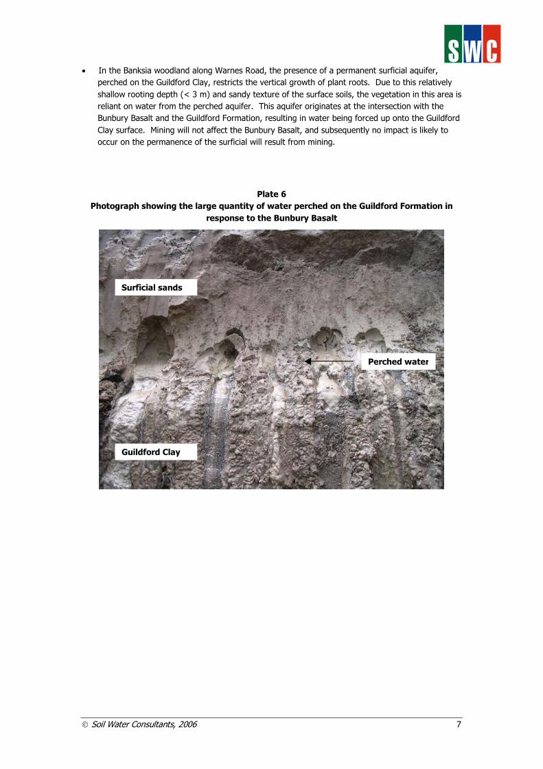
It is important note the difference between watertable, used in the context of this report, and the piezometric or potentiometric surface obtained from piezometers (Figure 3). Traditionally, the term watertable refers to the water level that occurs within an unconfined aquifer (Freeze and Cherry, 1979; Figure 3). This situation is generally confined to homogeneous sands, where the hydrostatic pressure of the aquifer or matric suction of the soil is less than or equal to atmospheric pressure (i.e. < 100 kPa or 10 m of water; Bouwer, 1978). In this situation, water occurs primarily in macro (3000 – 75 µm pores) and mesopores (75 – 30 µm pores) and water is free to move within the aquifer based on the continuity of this pore system (McKenzie et al., 2002).
On the SCP, unconfined aquifers are generally restricted to the deep sands of the Spearwood Dunal System, where deep homogeneous yellow sands overlie an impermeable basement (i.e. Leederville Formation). On the Pinjarra and Abba Plains, however, the dominance of the Guildford Formation, underlying the Bassendean Sands, restricts the formation of an unconfined aquifer. In such clayey soils water is held in micro (30 – 6 µm pores), ultramicro (6 – 0.2 µm pores) and cryptopores (< 0.2 µm pores) at hydrostatic or matric suctions greater that atmospheric pressure (i.e. > 100 kPa or 10 m of water). Consequently, no ‘free’ water occurs within the Guildford Formation, as it is held tightly within the clay matrix. Water stored within micro and ultramicropores (i.e. 30 – 0.2 µm) is available to plants, however this water is not free to move under gravity (McKenzie et al., 2002).
Piezometers installed in the Guildford Formation typically report a water level, and this level is often referred to as the watertable. This water level does not actually occur, and the water level observed in piezometers results from the release of the hydrostatic pressure in the soil. When the piezometer is installed, pressure within the piezometer tube is at atmospheric pressure, which is considerably less

Soil Water Consultants, 2006 2
S W Cthan the pressure that the water is stored in the soil; subsequently, water preferentially moves from the soil matrix (i.e. under high pressure) to the piezometer (i.e. under low pressure) resulting in ‘free-standing’ water in the piezometer. This water level therefore does not correspond to a watertable, as it only occurs in response to difference in pressure between the piezometer and the adjacent soil material. Therefore, given the absence of an unconfined aquifer in the Pinjarra and Abba Plains, the term ‘watertable’ has been used to define the upper surface of the confined aquifer, which is distinct from the piezometric or potentiometric surface (Figure 3).
The clayey soils of the Guildford Formation were deposited as a single, thick unit directly onto the underlying mineralised beach sands of the Yoganup Formation (Plate 3). This formation contains the heavy mineral orebody to be mined at Cloverdale and consists primarily of sand to sandy clay soils. These beach deposits also host the regional continuous Yoganup aquifer (Plate 4), and subsequently temporary dewatering of this aquifer within the mine area is required to access the heavy mineral orebody. The Yoganup aquifer is confined by the Guildford and Leederville Formations, and given the thickness of the overlying clayey Guildford Formation, the watertable throughout the Cloverdale Mine Region occurs at between 12 and 18 m below the soil surface. In response to the confining layers, the hydrostatic pressure within the Yoganup aquifer varies between 100 – 150 kN/m2, which creates a pressure head (hp) of 10 – 15 m (based on this pressure head the piezometric surface for the Yoganup aquifer at Cloverdale is likely to be 3 – 5 m below the land surface – this is observed in piezometers at this site and at the adjacent Yoganup West Minesite).
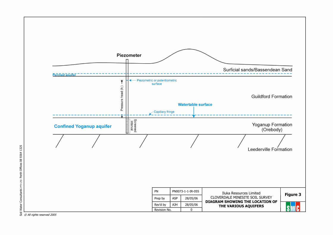
A detailed soil map for the proposed Cloverdale Minesite is presented in Figure 4, and the relationship of the soil types identified in the soil survey to the common soil types within the Abba Plain is provided in Table 1. A characteristic soil profile for each SMU is presented in Figure 5.
Table 1 Relationship of the SMU identified by soil survey to common Soil Associations and Series on
the Swan Coastal Plain SMU
(Present soil survey) Soil Type
(Present soil survey) Soil Association
(Bettenay et al., 1960) Soil Series
(Bettenay et al., 1960) Australian Soil Classification
(Isbell, 1998)
1a Shallow sandy duplex
Abba/Busselton Abba Podosol
1b Deep sandy duplex Abba/Busselton Abba Podosol
2 Gradational sandy loam
Abba/Busselton Busselton Podosol
3 Red loam Swan Belhus/Blythewood Ferrosol

Soil Water Consultants, 2006 3
S W C
Plate 1 General soil profile in the Abba Plain (Photo taken from the Yoganup West Minesite)
Plate 2 Redoximorphic status of the general soil profile (Photo taken from the Yoganup West Minesite)

Soil Water Consultants, 2006 4
S W C
Plate 3 Boundary between the Guildford and Yoganup Formations (Photo taken from the Yoganup
West Minesite)
Plate 4 Location of the Yoganup aquifer within the Yoganup Formation (Photo taken from the
Yoganup West Minesite)

Soil Water Consultants, 2006 5
S W CVegetation distribution and potential impacts from mining
The distribution of native vegetation within the Cloverdale Mine Region was mapped by Mattiske Consulting, and the distribution is presented in Figure 6. The vegetation consists of:
• open woodland of Agonis flexuosa, and Banksia attenuata and Banksia ilicifolia on elevated dunal ridges;
• open woodland of marri (Corymbia calophylla) and jarrah (Eucalyptus marginata) along road reserves;
• open forest and woodland of jarrah and marri on loamy soils.
The location of the identified vegetation in relation to the proposed Cloverdale minepit is shown in Figure 7.
The response of vegetation to proposed mining and associated groundwater drawdown will depend on the transpirational requirements of the vegetation, their root distribution, the plant available moisture content of the soil profile, and depth to groundwater. All of the soils within the Cloverdale Mine Region have very low plant available moisture contents1 (i.e. < 5 % plant available moisture; SWC 2006a), with the exception of the red loamy soils (SMU 32). Consequently, all vegetation throughout the Cloverdale Mine Region is required to explore a large volume of the soil profile to acquire sufficient soil moisture to meet their transpirational requirements, and roots were observed in all deep trenches exploring to depths > 9 m below the surface. From the previous section it was shown that groundwater occurs within the Yoganup Formation at approximately 15 m of depth (i.e. watertable at 15 m), and it is likely that the vegetation is accessing the capillary fringe at this depth. Given this depth to groundwater and the rooting depth, the vegetation within the Cloverdale Mine Region is classified as either Category 3 phreatophyte3 (Froend and Zencich, 2001) or as a non-phreatophyte acquiring all of its moisture requirements from the soil profile (for example, if plants roots explore to a depth of 15 m, then the soil profile can provide 750 mm of moisture assuming a plant available water content of 5 % (0.05 m3/m3 of soil) - this volume of water is likely to exceed to transpirational requirements of most native vegetation on the SCP).
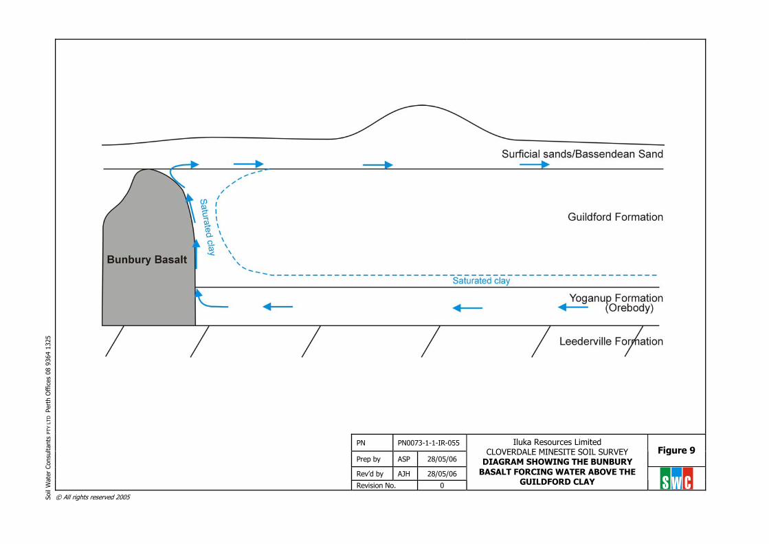
An exception to this general situation in the Cloverdale Mine Region occurs within the open woodland of Banksia attentuata and B. ilicifolia at the corner of Warnes Road and Downs Road (Figures 6 and 7). In this area, two trenches were excavated adjacent to the vegetation to a depth of 4 m (Plate 5), and both profiles showed that the vegetation has a relatively shallow root system (i.e. < 3 m), with roots only accessing the surficial sands overlying the Guildford clays. Deeper root growth is restricted by the presence of a permanent surficial aquifer perched on the Guildford Clay (Figure 3). This perched aquifer is approximately 0.3 m in thickness and has formed in response to groundwater being forced up unto the Guildford Clay by the Bunbury Basalt that is located in the southern portion of the proposed Cloverdale Minesite (Figures 8 and 9). Considerable perched water was observed in all trenches excavated in the southern portion of the mine region (Plate 6), and the gley colours and presence of a well developed coffee-rock layer indicate the permanence of this perched water. The Bunbury Basalt occurs outside of the proposed minepit and subsequently no impact is likely to occur to this geological formation or to the process by which water is forced up onto the upper surface of the Guildford
1 Plant available moisture content was determined using pressure plate apparatus and equates to the volume of water stored between 10 and 1500 kPa matric potential. 2 Plant available water content of the red loamy soils of SMU 3 vary from 8 – 12 % depending on the structure and texture of the soils (SWC, 2006a). 3 Phreatophyte is defined as vegetation that is partially or completely dependant on groundwater to meet its transpirational requirements. A Category 3 Phreatophyte is a vegetation that is using proportionately more water from the soil profile than from groundwater (Froend and Zencich, 2001).

Soil Water Consultants, 2006 6
S W CFormation; consequently, no impact on this vegetation is likely to occur in response to mining of the Cloverdale deposit.
Plate 5 Deep pale grey sands underlying the open Banksia woodland along Warnes Road
Summary
Based on this summary of the soils and vegetation within the Cloverdale Mine Region the following conclusions can be drawn regarding the potential impacts mining may have on the vegetation surrounding the proposed minepit:
• All of the soils within the area are deep, consisting of a surficial cover of sandy textured soil overlying a thick sandy clay to clay subsoil;
• Groundwater occurs within the Yoganup Formation, at depths of 12 – 15 m below the soil surface. Considerable water is stored within the Guildford Clays, however this water is held tightly within the clay matrix and subsequently is not considered ‘free-water” and does not flow under gravity. Only a small portion of this stored water is available to the vegetation (i.e. generally < 5 % plant available water);
• All vegetation, with the exception of the Banksia woodland along Warnes Road, have a very deep root system extending beyond 9 m of depth – most likely they extend to 12 – 15 m where they intersect the watertable and corresponding capillary fringe;
• At these rooting depths, the vegetation will acquire the majority of its water requirements for transpiration from the soil profile, with minimal extraction from the watertable. Subsequently, the majority of the vegetation can be considered non-phreatophytic, and no impact is likely to occur in response to mining and groundwater drawdown;
Soil Water Consultants, 2006 7
S W C• In the Banksia woodland along Warnes Road, the presence of a permanent surficial aquifer,
perched on the Guildford Clay, restricts the vertical growth of plant roots. Due to this relatively shallow rooting depth (< 3 m) and sandy texture of the surface soils, the vegetation in this area is reliant on water from the perched aquifer. This aquifer originates at the intersection with the Bunbury Basalt and the Guildford Formation, resulting in water being forced up onto the Guildford Clay surface. Mining will not affect the Bunbury Basalt, and subsequently no impact is likely to occur on the permanence of the surficial will result from mining.
Plate 6 Photograph showing the large quantity of water perched on the Guildford Formation in
response to the Bunbury Basalt
Guildford Clay
Surficial sands
Perched water

Soil Water Consultants, 2006 8
S W CReferences
Bettenay, E., McArthur, W.M. and Hingston, F.J. (1960). The Soil Associations of Part of the Swan Coastal Plain, Western Australia, Soils and Land Use Series No. 35, CSIRO Division of Soils, Melbourne, Australia.
Bouwer, H. Groundwater Hydrology, McGraw-Hill Kogakusha Ltd. Publishing, Tokyo, Japan, p. 4. Freeze, R.A. and Cherry, J.A. (1979). Groundwater, Prentice-Hall Publishing, New Jersey, p.48. Froend, R.H. and Zencich, S. (2001). Phreatophytic vegetation and groundwater study. Phase I:
Phreatophytic vegetation research review. A report to the Water Corporation, Western Australia. Centre for Ecosystem Management, Joondalup
Isbell, R.F. (1998). The Australian Soil Classification, CSIRO Publishing, Collingwood, Australia.
McDonald, R.C., Isbell, R.F., Speight, J.G., Walker, J. and Hopkins, M.S. (1998). Australian Soil and Land Survey: Field Handbook (2nd Ed.), CSIRO, Canberra, Australia.
McKenzie, N., Coughlan, K. and Cresswell, H. (2002). Soil Physical Measurement and Interpretation for Land Evaluation, CSIRO Publishing, Collingwood, Australia.
Soil Water Consultants (2003), Soil Management Plan for the Yoganup Extended Minesite, Unpublished report submitted to Iluka Resources Limited.
Soil Water Consultants (2004), Soil Management Plan for the Proposed Yoganup West Minesite, Unpublished report submitted to Iluka Resources Limited.
Soil Water Consultants (2006a), Soil Management Plan for the Proposed Cloverdale Minesite, Unpublished report submitted to Iluka Resources Limited.
Soil Water Consultants (2006b), Soil Management Plan for the Proposed Elgin Minesite, Unpublished report submitted to Iluka Resources Limited.

© All rights reserved 2005 Soil
Wat
er C
onsu
ltant
s PT
Y LT
D P
erth
Offi
ces
08 9
364
1325
PN PN0073-1-1-IR-055
Prep by ASP 07/05/06 Figure 1
Rev’d by AJH 07/05/06
Revision No. 0
Iluka Resources Limited CLOVERDALE MINESITE SOIL SURVEY
LOCATION OF EXCAVATED TRENCHES
S W C

© All rights reserved 2005 Soil
Wat
er C
onsu
ltant
s PT
Y LT
D P
erth
Offi
ces
08 9
364
1325
PN PN0073-1-1-IR-055
Prep by ASP 07/05/06 Figure 2
Rev’d by AJH 07/05/06
Revision No. 0
Iluka Resources Limited CLOVERDALE MINESITE SOIL SURVEY
EXPLORATION DRILLHOLE LOCATIONS
S W C
© All rights reserved 2005 Soil
Wat
er C
onsu
ltant
s PT
Y LT
D P
erth
Offi
ces
08 9
364
1325
PN PN0073-1-1-IR-055
Prep by ASP 28/05/06 Figure 3
Rev’d by AJH 28/05/06
Revision No. 0
Iluka Resources Limited CLOVERDALE MINESITE SOIL SURVEY
DIAGRAM SHOWING THE LOCATION OF THE VARIOUS AQUIFERS S W C
© All rights reserved 2005 Soil
Wat
er C
onsu
ltant
s PT
Y LT
D P
erth
Offi
ces
08 9
364
1325
PN PN0073-1-1-IR-055
Prep by ASP 07/05/06 Figure 4
Rev’d by AJH 07/05/06
Revision No. 0
Iluka Resources Limited CLOVERDALE MINESITE SOIL SURVEY SOIL DISTRIBUTION WITHIN THE
CLOVERDALE MINESITE S W C

© All rights reserved 2005 Soil
Wat
er C
onsu
ltant
s PT
Y LT
D P
erth
Offi
ces
08 9
364
1325
PN PN0073-1-1-IR-055
Prep by ASP 28/05/06 Figure 5
Rev’d by AJH 28/05/06
Revision No. 1
Iluka Resources Limited CLOVERDALE MINESITE SOIL SURVEY
CHARACTERISTIC SOIL PROFILES FOR EACH SMU WITHIN THE CLOVERDALE
DEPOSIT S W C

CL
CL
CL
A1
C3
C1
C1
C3
B1
M1
A1
A1M1
A1E1 C2 M1
C2
B1
PL
C3
E1
M1
CL
B1
B1
C2
C2
C2
E2
C1
M1
E1
366000mE
367000mE
370000mE
371000mE
372000mE
6277000mN
6279000mN
6280000mN
6281000mN
6278000mN
6282000mN
368000mE
369000mE
373000mE
LEGEND
A1 Woodland of Agonis flexuosa over pasture on sandy soils.
B1 Open Woodland of Banksia attenuata - Banksia ilicifolia
over Kunzea ericifolia, Podocarpus drouynianus and
Dasypogon bromeliifolius with emergent Eucalyptus
marginata subsp. marginata on sandy soils.
C1 Open Forest to Woodland of Corymbia calophylla -
Eucalyptus rudis over Melaleuca preissiana, Melaleuca
rhaphiophylla and Agonis flexuosa over Astartea scoparia,
Taxandria linearifolia and Cyathochaeta avenacea on
major water-courses.
C2 Open Forest to Woodland of Corymbia calophylla over
Banksia grandis, Kingia australis and Xanthorrhoea preissii
on loam soils.
C3 Woodland of Corymbia calophylla over pasture on loam
soils.
E1 Open Woodland of Eucalyptus marginata subsp. marginata
- Banksia attenuata - Banksia grandis - Xylomelum
occidentale over Stirlingia latifolia and Dasypogon
bromeliifolius on sandy soils.
E2 Open Forest of Eucalyptus marginata subsp. marginata -
Corymbia calophylla over low shrubs and herbs on
sandy-loam soils.
M1 Woodland of Melaleuca preissiana over Hypocalymma
angustifolium and mixed sedges.
CL Mostly cleared cultivated paddocks with occasional
Corymbia calophylla , Eucalyptus marginata subsp.
marginata and Melaleuca preissiana.
PL Plantations.
Survey Boundary
Figure: 1A A1Rev:Date: Dec 2005
Drawn: CAD Resources ~ www.cadresources.com.auTel: (08) 9246 3242 ~ Fax: (08) 9246 3202
Author: E M Mattiske
MATTISKE CONSULTING PTY LTD28 Central Road, Kalamunda ACN 063 507 175Phone: 9257 1625 Fax: 9257 1640
ScaleMGA94 (Zone 50)
0 250 500
MCPL Ref: IRL0508/213/05
CAD Ref: g1274veg.dgn
Scale: 1:10000
CLOVERDALEVEGETATION
ILUKA RESOURCES LIMITED
PLANTATION
ROAD
DOWNS ROAD
NORTH GOODWOOD
ROAD
GO
ODW
OO
D
ROAD
WA
RN
S
RO
AD
CLO
VE
RD
ALE
RO
AD
PL
Adam Pratt
6

© All rights reserved 2005 Soil
Wat
er C
onsu
ltant
s PT
Y LT
D P
erth
Offi
ces
08 9
364
1325
PN PN0073-1-1-IR-055
Prep by ASP 07/05/06 Figure 7
Rev’d by AJH 07/05/06
Revision No. 0
Iluka Resources Limited CLOVERDALE MINESITE SOIL SURVEY
VEGETATION DISTRIBUTION IN RELATION TO THE PROPOSED CLOVERDALE MINEPIT S W C

© All rights reserved 2005 Soil
Wat
er C
onsu
ltant
s PT
Y LT
D P
erth
Offi
ces
08 9
364
1325
PN PN0073-1-1-IR-055
Prep by ASP 28/05/06 Figure 8
Rev’d by AJH 28/05/06
Revision No. 0
Iluka Resources Limited CLOVERDALE MINESITE SOIL SURVEY
LOCATION OF THE BUNBURY BASALT
S W C
© All rights reserved 2005 Soil
Wat
er C
onsu
ltant
s PT
Y LT
D P
erth
Offi
ces
08 9
364
1325
PN PN0073-1-1-IR-055
Prep by ASP 28/05/06 Figure 9
Rev’d by AJH 28/05/06
Revision No. 0
Iluka Resources Limited CLOVERDALE MINESITE SOIL SURVEY
DIAGRAM SHOWING THE BUNBURY BASALT FORCING WATER ABOVE THE
GUILDFORD CLAY S W C