
Final Powerpoint (8-18).pptx
87
Transcript of Final Powerpoint (8-18).pptx


I. Introduction II. Preliminary Findings III. Methodology IV. Analysis V. Conclusions VI. Questions
3868 24th Street Parklet (Hosted by Martha Brothers) Photo by: San Francisco Planning Department
Opportunity Mapping: San Francisco Parklets & Plazas. Presentation delivered at the San Francisco Planning Department on May 29, 2014 by Gene Stroman

Pavement to Parks seeks to test the possibilities of underused areas of land by quickly and inexpensively converting them into new pedestrian spaces.
San Jose Guerrero Park, Photo by Jeremy Shaw
1331 9th Avenue Parklet (Hosted by Arizmendi Bakery) Photo by: Jack Verdoni Architecture
http://pavementtoparks.sfplanning.org/
PARKLETS
PLAZAS
Street Space à Pedestrian Space Temporary à Permanent
Opportunity Mapping: San Francisco Parklets & Plazas. Presentation delivered at the San Francisco Planning Department on May 29, 2014 by Gene Stroman

Pavement to Parks has influenced and been influenced by a number of cities across the globe.
Living Innovation Zones (SF), Lent Space (NYC), DUNE (Paris)
http://pavementtoparks.sfplanning.org/map-globe.htm http://bettercities.net/sites/default/files/Tactical%20Urbanism%20Final.pdf
http://parkingday.org/src/Parking_Day_Manifesto_Booklet.pdfl
Tactical Urbanism Mike Lydon, Street Plans Collaborative Generous Urbanism Blaine Merker, Rebar
The World of Parklets, Plazas, and Other Temporary Programs
Opportunity Mapping: San Francisco Parklets & Plazas. Presentation delivered at the San Francisco Planning Department on May 29, 2014 by Gene Stroman

Why study parklets and plazas?
Pavement to Parks is a young program and its projects are new concepts for which there are many basic unanswered questions. An empirical analysis has never been done before, and can be used in the selection of future proposals.
375 Valencia Street Parklet (Hosted by Four Barrel Coffee) Photo by: Great Streets
Opportunity Mapping: San Francisco Parklets & Plazas. Presentation delivered at the San Francisco Planning Department on May 29, 2014 by Gene Stroman

Research Questions
432 Colombus Parklet (Hosted by Cafe Greco) Photo by: Great Streets
How has Pavement to Parks grown since 2009?
Which Supervisor Districts contain the most parklets?
What is the relationship between parklets and NCDs?
Should the location of parklets be limited by street grade?
How does the bicycle network connect with the parklet network?
What are the different type of parklet sponsors?
Where do parklets serve best as a public seating space?
Which areas of the city are served by parklets or plazas? Which areas are not?
Which demographics do parklets and plazas serve in San Francisco?
Where are the best opportunities for future parklets and plazas?
In what land use and zoning mixes do parklets emerge?
Opportunity Mapping: San Francisco Parklets & Plazas. Presentation delivered at the San Francisco Planning Department on May 29, 2014 by Gene Stroman

Research Questions
Which areas of the city are served by parklets or plazas? Which areas are not?
Which demographics do parklets and plazas serve in San Francisco?
Where are the best opportunities for future parklets and plazas?
432 Colombus Parklet (Hosted by Cafe Greco) Photo by: Great Streets
In what land use and zoning mixes do parklets emerge?
Opportunity Mapping: San Francisco Parklets & Plazas. Presentation delivered at the San Francisco Planning Department on May 29, 2014 by Gene Stroman

Parklets in San Francisco
168 Proposed
PROPOSED: All parklet proposals ever submitted
Opportunity Mapping: San Francisco Parklets & Plazas. Presentation delivered at the San Francisco Planning Department on May 29, 2014 by Gene Stroman

Parklets in San Francisco
PROPOSED: All parklet proposals ever submitted INSTALLED: Currently in the ground
124
44
Installed
Proposed
Opportunity Mapping: San Francisco Parklets & Plazas. Presentation delivered at the San Francisco Planning Department on May 29, 2014 by Gene Stroman

Parklets in San Francisco
86
44
38
Pipeline
Installed
Proposed
PROPOSED: All other parklet proposals ever submitted INSTALLED: Currently in the ground PIPELINE: In some stage of design, permitting
Opportunity Mapping: San Francisco Parklets & Plazas. Presentation delivered at the San Francisco Planning Department on May 29, 2014 by Gene Stroman

P2P Plazas in San Francisco
Persia Triangle
San Jose- Guerrero Park
Annie Alley
Showplace Triangle
Jane Warner Plaza
INSTALLED: Currently in the ground or being upgraded PIPELINE: In some stage of design, permitting
Naples Green
4
2
Pipeline
Installed
Opportunity Mapping: San Francisco Parklets & Plazas. Presentation delivered at the San Francisco Planning Department on May 29, 2014 by Gene Stroman

P2P Projects
86
44
38
5
Plazas
Pipeline
Installed
Proposed
Parklet and Plaza Count as of March 2014
Opportunity Mapping: San Francisco Parklets & Plazas. Presentation delivered at the San Francisco Planning Department on May 29, 2014 by Gene Stroman

2009
Pavement to Parks established; First RFP
6
2009 2010 2011 2012 2013
Proposed
Opportunity Mapping: San Francisco Parklets & Plazas. Presentation delivered at the San Francisco Planning Department on May 29, 2014 by Gene Stroman

4 Pilot Parklets Installed
2010
38
4
2009 2010 2011 2012 2013
Installed
Proposed
Opportunity Mapping: San Francisco Parklets & Plazas. Presentation delivered at the San Francisco Planning Department on May 29, 2014 by Gene Stroman

2011
30
16
2009 2010 2011 2012 2013
Installed
Proposed
Opportunity Mapping: San Francisco Parklets & Plazas. Presentation delivered at the San Francisco Planning Department on May 29, 2014 by Gene Stroman

2012
36
15
2009 2010 2011 2012 2013
Installed
Proposed
Opportunity Mapping: San Francisco Parklets & Plazas. Presentation delivered at the San Francisco Planning Department on May 29, 2014 by Gene Stroman
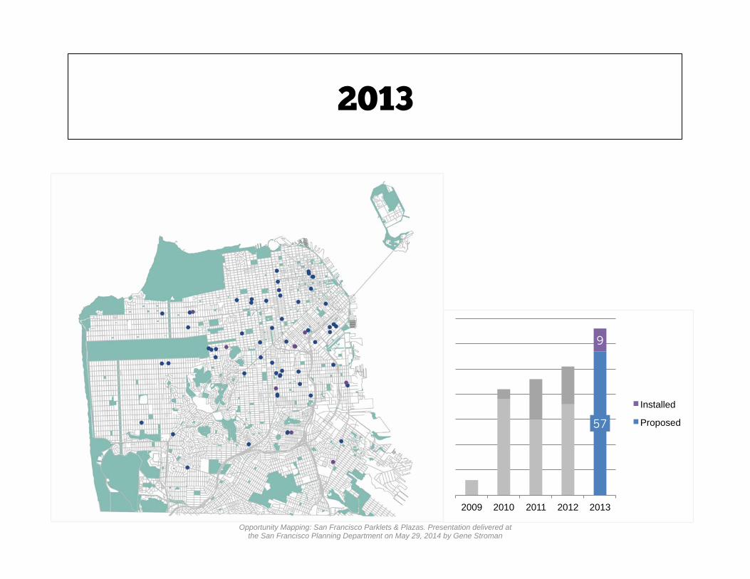
2013
57
9
2009 2010 2011 2012 2013
Installed
Proposed
Opportunity Mapping: San Francisco Parklets & Plazas. Presentation delivered at the San Francisco Planning Department on May 29, 2014 by Gene Stroman

# of Installed Parklets set to double within 12-24 months
2014 | Pipeline
As the program continues to expand, P2P needs to be methodical and fair in its selection of future proposals.
44
38
Pipeline
Installed
Opportunity Mapping: San Francisco Parklets & Plazas. Presentation delivered at the San Francisco Planning Department on May 29, 2014 by Gene Stroman

PRELIMINARY FINDINGS

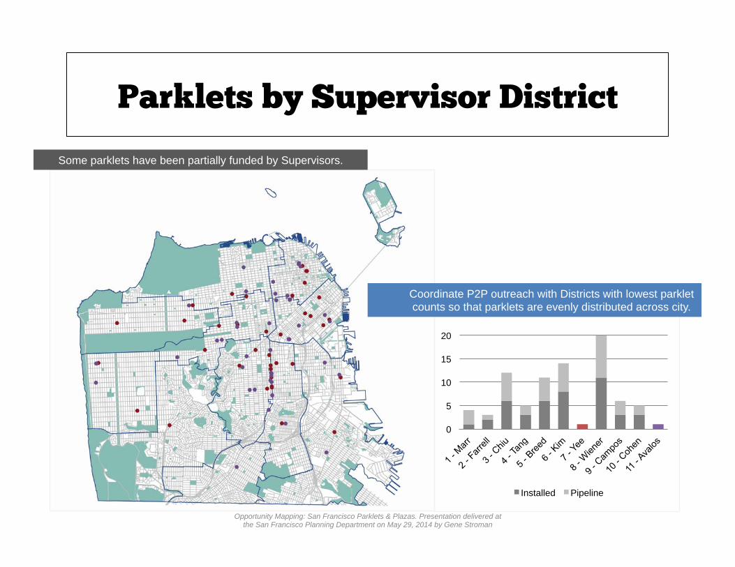
Parklets by Supervisor District
Some parklets have been partially funded by Supervisors.
0
5
10
15
20
25
Installed Pipeline
Coordinate P2P outreach with Districts with lowest parklet counts so that parklets are evenly distributed across city.
Opportunity Mapping: San Francisco Parklets & Plazas. Presentation delivered at the San Francisco Planning Department on May 29, 2014 by Gene Stroman
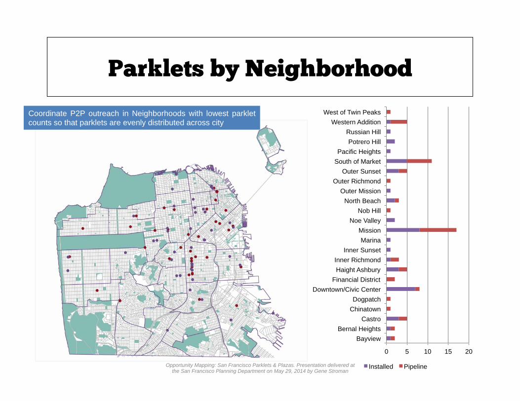
Parklets by Neighborhood
Coordinate P2P outreach in Neighborhoods with lowest parklet counts so that parklets are evenly distributed across city
0 5 10 15 20
Bayview Bernal Heights
Castro Chinatown Dogpatch
Downtown/Civic Center Financial District
Haight Ashbury Inner Richmond
Inner Sunset Marina
Mission Noe Valley
Nob Hill North Beach
Outer Mission Outer Richmond
Outer Sunset South of Market Pacific Heights
Potrero Hill Russian Hill
Western Addition West of Twin Peaks
Installed Pipeline Opportunity Mapping: San Francisco Parklets & Plazas. Presentation delivered at the San Francisco Planning Department on May 29, 2014 by Gene Stroman

Parklets & Street Grades
The majority of parklets are on a street with <5% slope
P2P is experimenting with building parklets on more extreme slopes
44
33
5
Installed Pipeline
Opportunity Mapping: San Francisco Parklets & Plazas. Presentation delivered at the San Francisco Planning Department on May 29, 2014 by Gene Stroman

Only a small number of Parklets fall along San Francisco’s bike network.
Access by Bicycle
http://www.sfmta.com/sites/default/files/maps/Bike%20map%20for%20web.pdf
19 12
25
26
Installed Pipeline
Bike Lane: striped, marked, and signed lanes for bicycle travel Bike Path: off-street multi-use path shared travel lane marked and signed for shared use Bike Route: shared travel lane marked and signed for shared use
Opportunity Mapping: San Francisco Parklets & Plazas. Presentation delivered at the San Francisco Planning Department on May 29, 2014 by Gene Stroman
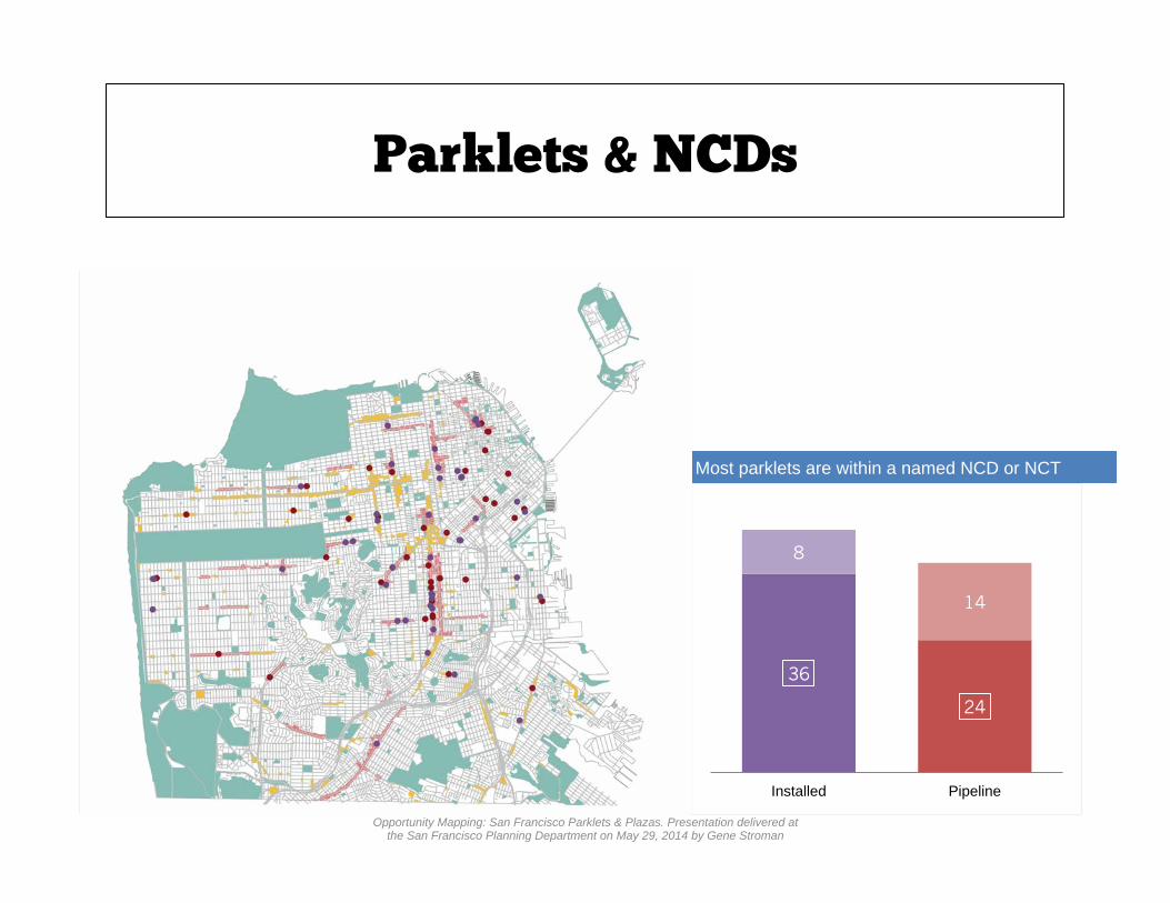
Most parklets are within a named NCD or NCT
Parklets & NCDs
36
24
8
14
Installed Pipeline
Opportunity Mapping: San Francisco Parklets & Plazas. Presentation delivered at the San Francisco Planning Department on May 29, 2014 by Gene Stroman

P2P should diversify parklet sponsor types in future RFPs.
Sponsor Types
Most parklets are sponsored by cafes or restaurants
0
5
10
15
20
25
30
Installed Pipeline
Opportunity Mapping: San Francisco Parklets & Plazas. Presentation delivered at the San Francisco Planning Department on May 29, 2014 by Gene Stroman

Tables & Chairs v. Parklets
Distribution of Tables & Chairs Permits
Tables and Chairs provide private seating, while parklets provide public seating
Opportunity Mapping: San Francisco Parklets & Plazas. Presentation delivered at the San Francisco Planning Department on May 29, 2014 by Gene Stroman

While some businesses apply for both permits, the majority of parklet sponsors do not have table and chair permits
Tables & Chairs v. Parklets
29
15
Installed
Parklet + T&C
Parklet Only
Opportunity Mapping: San Francisco Parklets & Plazas. Presentation delivered at the San Francisco Planning Department on May 29, 2014 by Gene Stroman


Tools | Buffer v. Network Buffer
What is the difference between the two types of buffering techniques? Why use a Network Buffer?
1/8 mi. Buffer
1/8 mi. Network Buffer
Opportunity Mapping: San Francisco Parklets & Plazas. Presentation delivered at the San Francisco Planning Department on May 29, 2014 by Gene Stroman

A Buffer uses a straight radius in its calculation of a walking distance.
1/8 mi. Buffer
Tools | Buffer v. Network Buffer
Opportunity Mapping: San Francisco Parklets & Plazas. Presentation delivered at the San Francisco Planning Department on May 29, 2014 by Gene Stroman

A Network Buffer uses the existing street network and incorporates turns, inclines, and other factors in its calculation of walking distance.
1/8 mi. Network Buffer
Tools | Buffer v. Network Buffer
Opportunity Mapping: San Francisco Parklets & Plazas. Presentation delivered at the San Francisco Planning Department on May 29, 2014 by Gene Stroman

Tools | Buffer v. Network Buffer
Network Buffers create a more precise, realistic walking distance away from a certain point.
1/8 mi. Buffer
1/8 mi. Network Buffer
Opportunity Mapping: San Francisco Parklets & Plazas. Presentation delivered at the San Francisco Planning Department on May 29, 2014 by Gene Stroman

Determining Walkshed
Parklets & Plazas • 1/8 mi. (3 min) walkshed for Parklets • 1/4 mi. (5 min) walkshed for P2P
Plazas
A Walkshed is the distance one feels comfortable walking to an amenity.
• SF General Plan: Recreation & Open Space Element http://www.sf-planning.org/ftp/general_plan/I3_Rec_and_Open_Space.htm • Congress for the New Urbanism Charter http://www.cnu.org/sites/files/charter_book.pdf • Manhattan East Side Open Space Index http://www.ny4p.org/research/osi/EastSideOSI.pdf
Opportunity Mapping: San Francisco Parklets & Plazas. Presentation delivered at the San Francisco Planning Department on May 29, 2014 by Gene Stroman
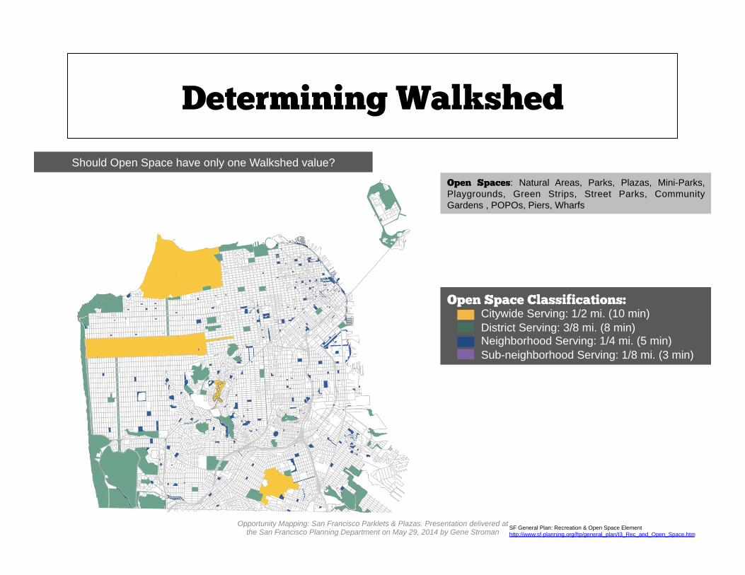
Determining Walkshed
Open Spaces: Natural Areas, Parks, Plazas, Mini-Parks, Playgrounds, Green Strips, Street Parks, Community Gardens , POPOs, Piers, Wharfs
Open Space Classifications: Citywide Serving: 1/2 mi. (10 min) District Serving: 3/8 mi. (8 min) Neighborhood Serving: 1/4 mi. (5 min) Sub-neighborhood Serving: 1/8 mi. (3 min)
Should Open Space have only one Walkshed value?
SF General Plan: Recreation & Open Space Element http://www.sf-planning.org/ftp/general_plan/I3_Rec_and_Open_Space.htm
Opportunity Mapping: San Francisco Parklets & Plazas. Presentation delivered at the San Francisco Planning Department on May 29, 2014 by Gene Stroman

Buffer | multi-ring
Mutli-ring buffer (5 and 10 min.) on Installed Parklets
Opportunity Mapping: San Francisco Parklets & Plazas. Presentation delivered at the San Francisco Planning Department on May 29, 2014 by Gene Stroman

Buffer | installed
Final (3 min.) Buffer on Installed Parklets
Opportunity Mapping: San Francisco Parklets & Plazas. Presentation delivered at the San Francisco Planning Department on May 29, 2014 by Gene Stroman
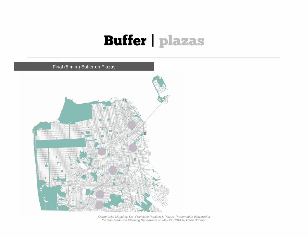
Buffer | plazas
Final (5 min.) Buffer on Plazas
Opportunity Mapping: San Francisco Parklets & Plazas. Presentation delivered at the San Francisco Planning Department on May 29, 2014 by Gene Stroman

Buffer | open space
Buffer on all Open Space by Classification
Open Space Classifications: Citywide Serving: 1/2 mi. (10 min) District Serving: 3/8 mi. (7 min) Neighborhood Serving: 1/4 mi. (5 min) Sub-neighborhood Serving: 1/8 mi. (3 min)
Opportunity Mapping: San Francisco Parklets & Plazas. Presentation delivered at the San Francisco Planning Department on May 29, 2014 by Gene Stroman

Buffer | final
Buffer on Open Space + Plazas
Opportunity Mapping: San Francisco Parklets & Plazas. Presentation delivered at the San Francisco Planning Department on May 29, 2014 by Gene Stroman

Buffer | final
Buffer on Open space + Plazas + Installed Parklets
Opportunity Mapping: San Francisco Parklets & Plazas. Presentation delivered at the San Francisco Planning Department on May 29, 2014 by Gene Stroman

Buffer | final
Final Buffer
Opportunity Mapping: San Francisco Parklets & Plazas. Presentation delivered at the San Francisco Planning Department on May 29, 2014 by Gene Stroman

Buffer | final
Final Buffer v. Pipeline Parklets
Opportunity Mapping: San Francisco Parklets & Plazas. Presentation delivered at the San Francisco Planning Department on May 29, 2014 by Gene Stroman

Buffer | priority
Priority Pipeline Parklets
The simple buffer takes over most of city, leaving far too small of an opportunity area. A network buffer can produce a more realistic catchment area that will include more pipeline parklets.
Opportunity Mapping: San Francisco Parklets & Plazas. Presentation delivered at the San Francisco Planning Department on May 29, 2014 by Gene Stroman

Network Buffer | installed
Network Buffer (3 min.) on Installed Parklets
Opportunity Mapping: San Francisco Parklets & Plazas. Presentation delivered at the San Francisco Planning Department on May 29, 2014 by Gene Stroman

Network Buffer | plazas
Network Buffer (5 min.) on P2P Plazas
Opportunity Mapping: San Francisco Parklets & Plazas. Presentation delivered at the San Francisco Planning Department on May 29, 2014 by Gene Stroman

Network Buffer | open space
Network Buffer on all Open Space by Classification
Open Space Classifications: Citywide Serving: 1/2 mi. (10 min) District Serving: 3/8 mi. (7 min) Neighborhood Serving: 1/4 mi. (5 min) Sub-neighborhood Serving: 1/8 mi. (3 min)
Opportunity Mapping: San Francisco Parklets & Plazas. Presentation delivered at the San Francisco Planning Department on May 29, 2014 by Gene Stroman

Network Buffer
Network Buffer on Open Space + Plazas
Opportunity Mapping: San Francisco Parklets & Plazas. Presentation delivered at the San Francisco Planning Department on May 29, 2014 by Gene Stroman

Network Buffer
Network Buffer on Open Space + Plazas+ Installed Parklets
Opportunity Mapping: San Francisco Parklets & Plazas. Presentation delivered at the San Francisco Planning Department on May 29, 2014 by Gene Stroman

Network Buffer | final
Final Network Buffer
Opportunity Mapping: San Francisco Parklets & Plazas. Presentation delivered at the San Francisco Planning Department on May 29, 2014 by Gene Stroman

Network Buffer | pipeline
Final Network Buffer v. Pipeline Parklets
Opportunity Mapping: San Francisco Parklets & Plazas. Presentation delivered at the San Francisco Planning Department on May 29, 2014 by Gene Stroman

Network Buffer | priority pipeline
Priority Pipeline Parklets
Opportunity Mapping: San Francisco Parklets & Plazas. Presentation delivered at the San Francisco Planning Department on May 29, 2014 by Gene Stroman

ANALYSIS

Q1: In what land use and zoning mixes do parklets emerge?

Parklet Walkshed Network Buffer
Network Buffer on Parklets
Opportunity Mapping: San Francisco Parklets & Plazas. Presentation delivered at the San Francisco Planning Department on May 29, 2014 by Gene Stroman

Parklet Walkshed Network Buffer
All blocks within Parklet Network Buffer
Opportunity Mapping: San Francisco Parklets & Plazas. Presentation delivered at the San Francisco Planning Department on May 29, 2014 by Gene Stroman

Parklets & Land Use
1/8 mi. Parklet Walkshed Land Use Mix
SF Planning, Land Use Index http://www.sf-planning.org/ftp/general_plan/Land_Use_Index_August_2011.pdf
0%
10%
20%
30%
40%
50%
60%
70%
80%
90%
100%
Parklet City
Medical/Health
Cultural / Institutional
Services
Mixed Use
PDR
Other
Retail / Ent.
Mixed-Res
Residential
Compared to city as a whole, service area for parklets includes a greater percentage of Residential Mixed Use and Retail/Entertainment Land Uses.
Opportunity Mapping: San Francisco Parklets & Plazas. Presentation delivered at the San Francisco Planning Department on May 29, 2014 by Gene Stroman

Parklets & Zoning
1/8 mi. Parklet Walkshed Zoning Districts
SF Planning, Zoning Map http://www.sf-planning.org/index.aspx?page=1569
Compared to city as a whole, service area for parklets includes a greater percentage of Commercial Zoning.
0%
10%
20%
30%
40%
50%
60%
70%
80%
90%
100%
Parklet City
Office
Other
Mixed-Use
PDR
Mixed-Res
Commercial
Residential
Opportunity Mapping: San Francisco Parklets & Plazas. Presentation delivered at the San Francisco Planning Department on May 29, 2014 by Gene Stroman

Q2: Which areas of the city are served by parklets or plazas? Which areas are not?
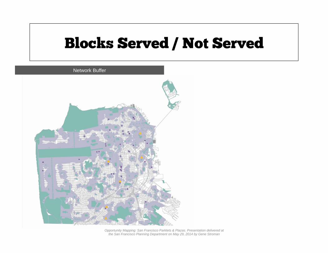
Blocks Served / Not Served
Network Buffer
Opportunity Mapping: San Francisco Parklets & Plazas. Presentation delivered at the San Francisco Planning Department on May 29, 2014 by Gene Stroman

Blocks Served / Not Served
Access: population within the associated walkshed of an installed parklet, P2P plaza, or open space.
Opportunity Mapping: San Francisco Parklets & Plazas. Presentation delivered at the San Francisco Planning Department on May 29, 2014 by Gene Stroman
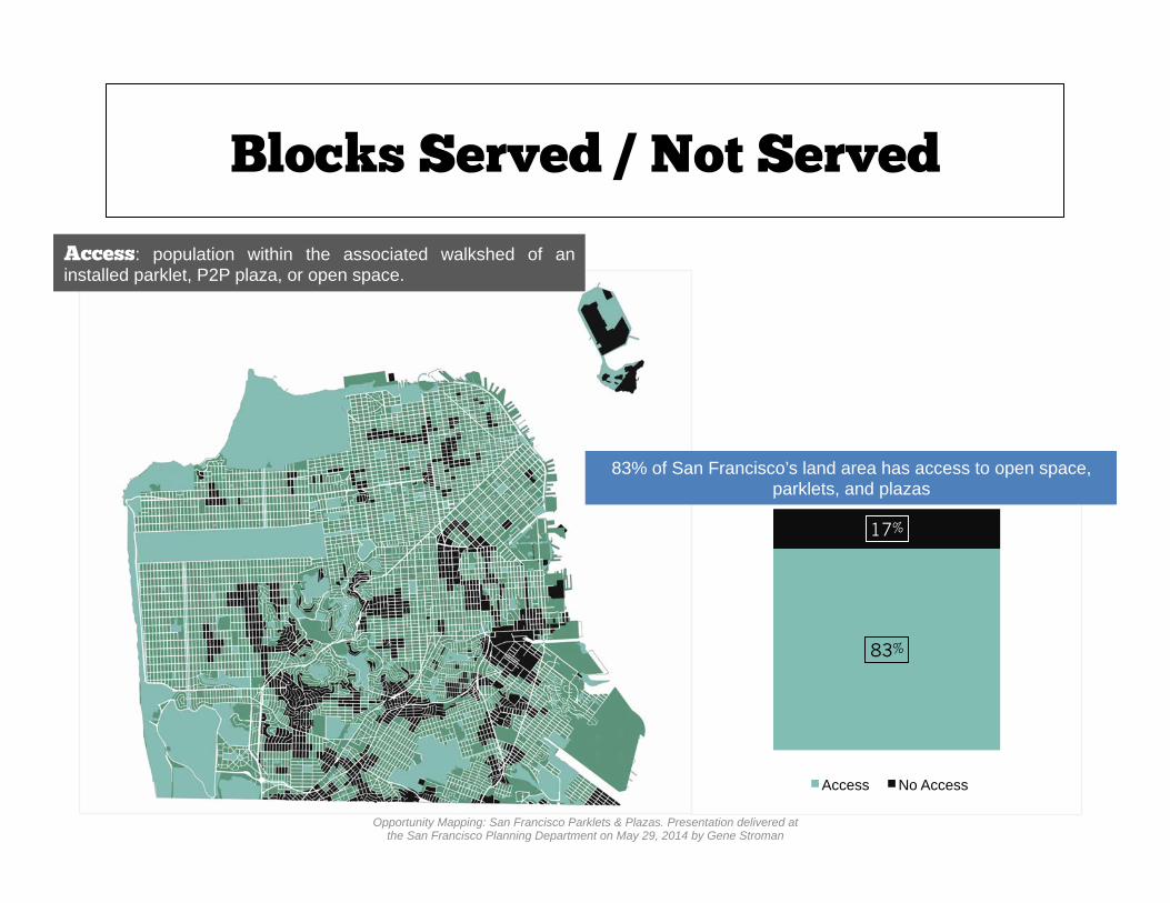
Blocks Served / Not Served
83% of San Francisco’s land area has access to open space, parklets, and plazas
Access: population within the associated walkshed of an installed parklet, P2P plaza, or open space.
83%
17%
Access No Access
Opportunity Mapping: San Francisco Parklets & Plazas. Presentation delivered at the San Francisco Planning Department on May 29, 2014 by Gene Stroman

Q3: Which demographics do parklets and plazas serve in San Francisco?

The Census & GIS
• Short survey (fewer categories) • Samples entire population every 10
years (less frequent) • Larger population sample • Smaller geographic unit: blocks and
block groups
• Long survey • Samples small percentage of
population every year • Less accurate (data is an estimate,
includes margin of error) • Larger geographic unit: Census Tracts
American Community Survey (2012)
Income, Education, Transportation
Decennial Census (2010) Race, Age
Opportunity Mapping: San Francisco Parklets & Plazas. Presentation delivered at the San Francisco Planning Department on May 29, 2014 by Gene Stroman

Decennial Census Data (Blocks)

Parklet Walkshed Network Buffer
Network Buffer on Parklets
Opportunity Mapping: San Francisco Parklets & Plazas. Presentation delivered at the San Francisco Planning Department on May 29, 2014 by Gene Stroman
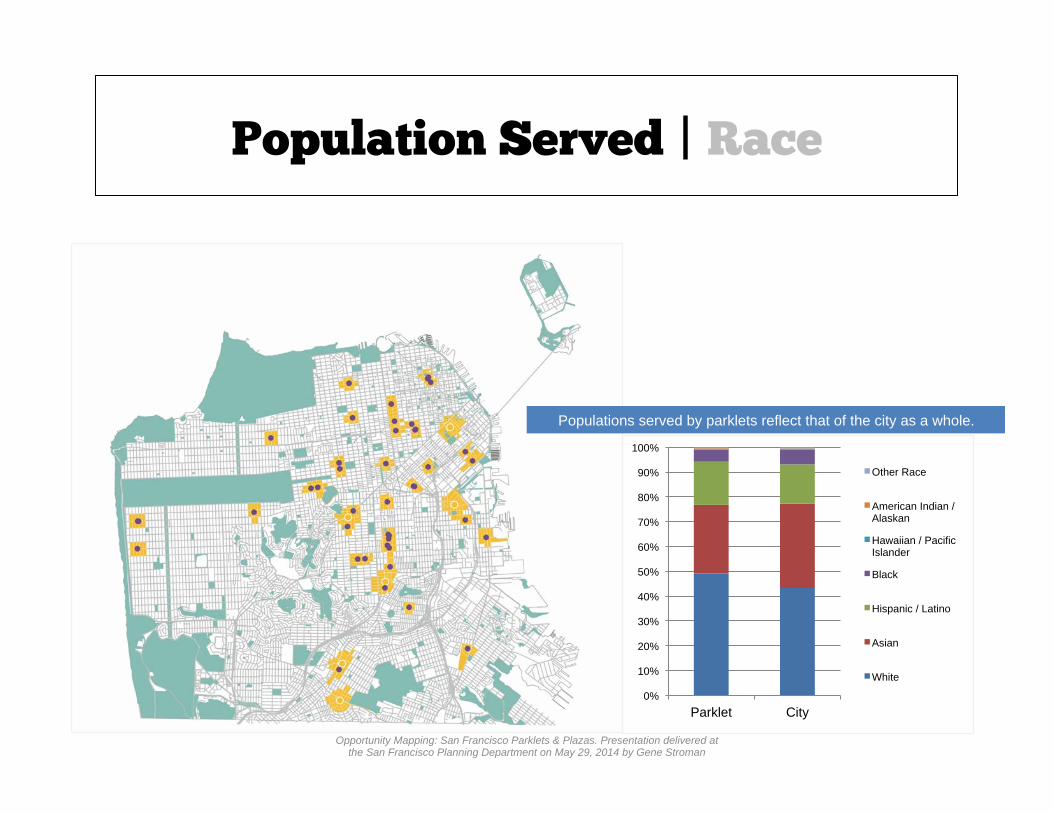
Population Served | Race
Populations served by parklets reflect that of the city as a whole.
0%
10%
20%
30%
40%
50%
60%
70%
80%
90%
100%
Parklet City
Other Race
American Indian / Alaskan
Hawaiian / Pacific Islander
Black
Hispanic / Latino
Asian
White
Opportunity Mapping: San Francisco Parklets & Plazas. Presentation delivered at the San Francisco Planning Department on May 29, 2014 by Gene Stroman

Population Served | Age
Populations served by parklets reflect that of the city as a whole.
0%
10%
20%
30%
40%
50%
60%
70%
80%
90%
100%
Parklet City
65+
45-64
25-44
18-24
17 and Under
Opportunity Mapping: San Francisco Parklets & Plazas. Presentation delivered at the San Francisco Planning Department on May 29, 2014 by Gene Stroman

ACS Data (Census Tracts)

Population Served | Income
Populations served by parklets reflect that of the city as a whole.
0%
10%
20%
30%
40%
50%
60%
70%
80%
90%
100%
Parklet City
$100K +
$65K - $100K
$50K - $65K
$40K - $50K
$30K - $40K
$20K - $30K
$10K - $20K
$1 - $10K
Opportunity Mapping: San Francisco Parklets & Plazas. Presentation delivered at the San Francisco Planning Department on May 29, 2014 by Gene Stroman

Population Served | Education
Populations served by parklets reflect that of the city as a whole.
0%
10%
20%
30%
40%
50%
60%
70%
80%
90%
100%
Parklet City
Bachelor's Degree or Higher
Some College or Associates Degree
High School Graduate
Less than High School Graduate
Opportunity Mapping: San Francisco Parklets & Plazas. Presentation delivered at the San Francisco Planning Department on May 29, 2014 by Gene Stroman

Population Served | Transportation
Populations served by parklets reflect that of the city as a whole.
0%
10%
20%
30%
40%
50%
60%
70%
80%
90%
100%
Parklet City
Taxi, Motorcycle, Bicycle, Other
Walked
Public Transportation
Automobile (Carpool)
Automobile (Alone)
Opportunity Mapping: San Francisco Parklets & Plazas. Presentation delivered at the San Francisco Planning Department on May 29, 2014 by Gene Stroman

CAPPUCCINO URBANISM?

Q4: Where are the best opportunities for future parklets and plazas?

Opportunity Streets
Network Buffer
Opportunity Mapping: San Francisco Parklets & Plazas. Presentation delivered at the San Francisco Planning Department on May 29, 2014 by Gene Stroman

Opportunity Streets
Street Segments in “No Access” areas
Opportunity Mapping: San Francisco Parklets & Plazas. Presentation delivered at the San Francisco Planning Department on May 29, 2014 by Gene Stroman

Opportunity Streets
Street Segments with a grade of less than 5%
Opportunity Mapping: San Francisco Parklets & Plazas. Presentation delivered at the San Francisco Planning Department on May 29, 2014 by Gene Stroman

Opportunity Streets
Street Segments within a named NCD or NCT
OPPORTUNITY STREETS = - Are within areas of the city that do not currently have access to parklets, plazas, or other types of open space - Have a street grade of less than 5% - Are Within an NCD, NCT, or other NC
Opportunity Mapping: San Francisco Parklets & Plazas. Presentation delivered at the San Francisco Planning Department on May 29, 2014 by Gene Stroman

Opportunity Streets
Opportunity Streets v. Pipeline Parklets
Opportunity Mapping: San Francisco Parklets & Plazas. Presentation delivered at the San Francisco Planning Department on May 29, 2014 by Gene Stroman

Opportunity Streets
Priority Pipeline Parklets
Opportunity Mapping: San Francisco Parklets & Plazas. Presentation delivered at the San Francisco Planning Department on May 29, 2014 by Gene Stroman

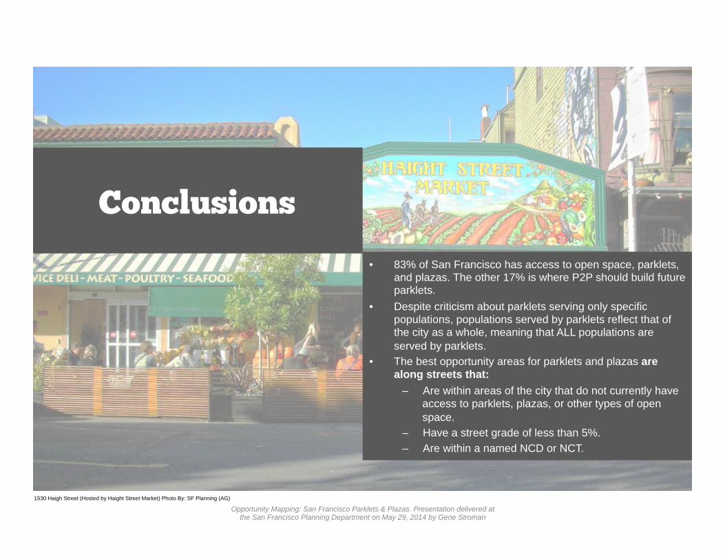
Conclusions
1530 Haigh Street (Hosted by Haight Street Market) Photo By: SF Planning (AG)
• The parklet program is growing every year. P2P should ensure geographic equity in its selection of future proposals.
• The distribution of parklets is uneven across Supervisor Districts and Neighborhoods. P2P should coordinate more closely with the entities with lowest parklet counts to ensure geographic equity.
• Most parklets are within an NCD or NCT and are streets with grades of less than 5%.
• Only a small number of parklets fall along San Francisco’s bike network.
• Most parklet sponsors are either cafes or restaurants. P2P should diversify sponsor type in future RFP selection.
• The majority of parklet sponsors do not also have table and chair permits.
• Compared to city as a whole, the service area for parklets includes a greater percentage of Residential Mixed Use or Retail / Entertainment Land Use and is within a Commercial Zoning District.
Opportunity Mapping: San Francisco Parklets & Plazas. Presentation delivered at the San Francisco Planning Department on May 29, 2014 by Gene Stroman
Conclusions
• 83% of San Francisco has access to open space, parklets, and plazas. The other 17% is where P2P should build future parklets.
• Despite criticism about parklets serving only specific populations, populations served by parklets reflect that of the city as a whole, meaning that ALL populations are served by parklets.
• The best opportunity areas for parklets and plazas are along streets that:
– Are within areas of the city that do not currently have access to parklets, plazas, or other types of open space.
– Have a street grade of less than 5%. – Are within a named NCD or NCT.
1530 Haigh Street (Hosted by Haight Street Market) Photo By: SF Planning (AG)
Opportunity Mapping: San Francisco Parklets & Plazas. Presentation delivered at the San Francisco Planning Department on May 29, 2014 by Gene Stroman

Simple Pleasures Parklet, Photo by San Francisco Planning Department, Ilaria Salvadori
Further Research
Q: How does population density affect the opportunity study for parklets and plazas? Q: What makes a successful parklet? (Design, accessibility, side of street, sponsor type?) Q: At what locations can a parklet most benefit a neighborhood? Q: How do people arrive at parklets? Further explore link with bicycle infrastructure and SF’s Green Connections program. Q: Prove / disprove the assumption that people will only walk a few blocks to use a parklet Q: Does street slope affect the popularity / effectiveness of a parklet?
Opportunity Mapping: San Francisco Parklets & Plazas. Presentation delivered at the San Francisco Planning Department on May 29, 2014 by Gene Stroman

Trouble Coffee Bayview Parklet, BaviewPhotos by Ben Frombgen, Architect
Questions

• Robin Abad & Ilaria Salvadori • Sahiti Karempudi & SF Parks Alliance • Mike Webster • Gary Chen • Teresa Ojeda • Diana Sokolove & Teresa Oropeza • Sabrina Barekzai • Friends of City Planning
Acknowledgements
Trouble Coffee Bayview Parklet, BaviewPhotos by Ben Frombgen, Architect Opportunity Mapping: San Francisco Parklets & Plazas. Presentation delivered at
the San Francisco Planning Department on May 29, 2014 by Gene Stroman
![FINAL budget presentation sept 2013.pptx [Read-Only]...Microsoft PowerPoint - FINAL budget presentation sept 2013.pptx [Read-Only] Author pschwarz Created Date 9/19/2013 10:27:50 AM](https://static.fdocuments.us/doc/165x107/5f43207240b07d0fc8449fcd/final-budget-presentation-sept-2013pptx-read-only-microsoft-powerpoint-.jpg)


![[MS-PPTX]: PowerPoint (.pptx) Extensions to the Office ...MS-PPTX... · [MS-PPTX] - v20181211 PowerPoint (.pptx) Extensions to the Office Open XML File Format Copyright © 2018 Microsoft](https://static.fdocuments.us/doc/165x107/5edb5856ad6a402d666584d0/ms-pptx-powerpoint-pptx-extensions-to-the-office-ms-pptx-ms-pptx.jpg)


![FINAL PPT ADU PowerPoint Split Funded Defined Benefit ...Title: Microsoft PowerPoint - FINAL PPT_ADU PowerPoint_Split Funded Defined Benefit Plans [Client] (PT-40198-03).pptx Author:](https://static.fdocuments.us/doc/165x107/5f3f57bb7cac921b7c580d1e/final-ppt-adu-powerpoint-split-funded-defined-benefit-title-microsoft-powerpoint.jpg)


![[MS-PPTX]: PowerPoint (.pptx) Extensions to the Office ...interoperability.blob.core.windows.net/files/MS-PPTX/[MS-PPTX... · 1 / 76 [MS-PPTX] — v20140428 PowerPoint (.pptx) Extensions](https://static.fdocuments.us/doc/165x107/5ae7f6357f8b9a6d4f8ed3b3/ms-pptx-powerpoint-pptx-extensions-to-the-office-ms-pptx1-76-ms-pptx.jpg)

![[MS-PPTX]: PowerPoint (.pptx) Extensions to the …interoperability.blob.core.windows.net/files/MS-PPTX/[MS...1 / 78 [MS-PPTX] - v20150904 PowerPoint (.pptx) Extensions to the Office](https://static.fdocuments.us/doc/165x107/5ad11a0c7f8b9aff738b549d/ms-pptx-powerpoint-pptx-extensions-to-the-ms1-78-ms-pptx-v20150904.jpg)