Final Mitigated Negative Declaration and Mitigation ...deltaconservancy.ca.gov/docs/AI 5.1 Staff...
112
Agenda Item: 5 Attachment: 1 Meeting Date: September 2, 2015 Page 1 Final Mitigated Negative Declaration and Mitigation Monitoring and Reporting Program for the Arundo Control and Restoration Project in the Cache Slough Complex Staff Report Recommendations Staff recommends that the Conservancy Board approve and adopt the “Resolution of the Sacramento‐San Joaquin Delta Conservancy Adopting the Final Mitigated Negative Declaration and Mitigation Monitoring and Reporting Program for the Arundo Control and Restoration Project in the Cache Slough Complex and Approving Implementation of the Project.” Background In April 2014, the Conservancy received approximately $1 million from the Department of Water Resources (DWR) to implement an Arundo Control and Restoration Program. After agreements were in place with contractors in July 2014, the mapping of Arundo infestations throughout the Delta and outreach to identify willing landowners to participate in the Cache Slough Complex (CSC) Pilot Project began. Under this agreement with DWR, the CSC Pilot Project comprises 15 acres of Arundo control and restoration of native riparian vegetation in the CSC. The Conservancy is responsible for permits and environmental compliance for this project. To comply with the California Environmental Quality Act (CEQA), an Initial Study was prepared to: (1) determine whether project implementation would result in potential significant or significant effects to the environment, and (2) incorporate mitigation measures into the project design, as necessary, to eliminate the project’s potential significant or significant effects or reduce them to a less‐than‐significant level. As specified in CEQA Guidelines Section 15367, the lead agency for CEQA compliance is the public agency that has the principal responsibilities for carrying out or approving the project. The Conservancy has principal responsibility for carrying out the project and is therefore the CEQA lead agency for this Initial Study. An Initial Study for the Arundo Control and Restoration Project in the Cache Slough Complex was sent to the State Clearinghouse on June 19, 2015 for a 30‐day public review period. Two letters were received during the 30‐day comment period. The comments did not require substantial changes in the Initial Study or in the project, and no significant effects were identified. Based on the Initial Study, the Conservancy has determined that the proposed project would not have any significant effects on the environment after implementation of mitigation measures. The Conservancy in all has determined that adoption of a Mitigated Negative Declaration is appropriate and that the preparation of an Environmental Impact Report (EIR) will not be required. The Mitigated Negative Declaration and a Mitigation Monitoring and Reporting Program will be adopted to ensure compliance with the required mitigation 1450 Halyard Drive, Suite 6 West Sacramento, CA 95691 www.deltaconservancy.ca.gov
Transcript of Final Mitigated Negative Declaration and Mitigation ...deltaconservancy.ca.gov/docs/AI 5.1 Staff...
Agenda Item: 5 Attachment: 1
Meeting Date: September 2, 2015 Page 1
Final Mitigated Negative Declaration and Mitigation Monitoring and Reporting Program for the Arundo Control and Restoration Project in the Cache Slough Complex
Staff Report
Recommendations Staff recommends that the Conservancy Board approve and adopt the “Resolution of the Sacramento‐San Joaquin Delta Conservancy Adopting the Final Mitigated Negative Declaration and Mitigation Monitoring and Reporting Program for the Arundo Control and Restoration Project in the Cache Slough Complex and Approving Implementation of the Project.” Background In April 2014, the Conservancy received approximately $1 million from the Department of Water Resources (DWR) to implement an Arundo Control and Restoration Program. After agreements were in place with contractors in July 2014, the mapping of Arundo infestations throughout the Delta and outreach to identify willing landowners to participate in the Cache Slough Complex (CSC) Pilot Project began. Under this agreement with DWR, the CSC Pilot Project comprises 15 acres of Arundo control and restoration of native riparian vegetation in the CSC. The Conservancy is responsible for permits and environmental compliance for this project. To comply with the California Environmental Quality Act (CEQA), an Initial Study was prepared to: (1) determine whether project implementation would result in potential significant or significant effects to the environment, and (2) incorporate mitigation measures into the project design, as necessary, to eliminate the project’s potential significant or significant effects or reduce them to a less‐than‐significant level. As specified in CEQA Guidelines Section 15367, the lead agency for CEQA compliance is the public agency that has the principal responsibilities for carrying out or approving the project. The Conservancy has principal responsibility for carrying out the project and is therefore the CEQA lead agency for this Initial Study. An Initial Study for the Arundo Control and Restoration Project in the Cache Slough Complex was sent to the State Clearinghouse on June 19, 2015 for a 30‐day public review period. Two letters were received during the 30‐day comment period. The comments did not require substantial changes in the Initial Study or in the project, and no significant effects were identified. Based on the Initial Study, the Conservancy has determined that the proposed project would not have any significant effects on the environment after implementation of mitigation measures. The Conservancy in all has determined that adoption of a Mitigated Negative Declaration is appropriate and that the preparation of an Environmental Impact Report (EIR) will not be required. The Mitigated Negative Declaration and a Mitigation Monitoring and Reporting Program will be adopted to ensure compliance with the required mitigation
1450 Halyard Drive, Suite 6West Sacramento, CA 95691 www.deltaconservancy.ca.gov

Agenda Item: 5 Attachment: 1
Meeting Date: September 2, 2015 Page 2 measures. With implementation of the mitigation measures, the proposed project would have no significant effect on the environment.
Contact Person
Kristal Davis Fadtke, Senior Environmental Scientist
Sacramento‐San Joaquín Delta Conservancy
Phone: (916) 375‐4994
Attachments:
1A: Final Mitigated Negative Declaration, Response to Public Comments, and Mitigation Monitoring and Reporting
Program
1B: Initial Study and Proposed Mitigated Negative Declaration for the Arundo Control and Restoration Project in the
Cache Slough Complex
Final Mitigated Negative Declaration, Response to Public Comments,
& Mitigation Monitoring and Reporting Program
Arundo Control and Restoration Project
in the Cache Slough Complex
State Clearinghouse #2015062060
Prepared by:
Sacramento‐San Joaquin Delta Conservancy Lead Agency
August 2015

2
Table of Contents
Final Mitigated Negative Declaration …………………………………………………………………………..…………………………3
Comment Letter #1 …………………………………………………………………………………………………….…………………………10
Response to Comments ..……………………….………………………………………………………………………………………..…..13
Comment Letter #2 ……………………………………………………………………………………………………………………..……….14
Response to Comments ……………………………………………………………………………..………………………………..………18
Mitigation Monitoring and Reporting Program …………………………………………………………………………………….19
List of Tables
1. Mitigation Monitoring and Reporting Program …..………………………………………….……………………………….20
List of Figures
1. Project Location ………………………………………………………………………………………………………………….…………….9

3
Final Mitigated Negative Declaration
Arundo Control and Restoration Project in the Cache Slough Complex
Lead Agency
Sacramento‐San Joaquin Delta Conservancy (Conservancy), 1450 Halyard Drive, Suite 6, West
Sacramento, CA 95691
Project Description
With the goal of improving Delta ecosystems, the Conservancy proposes to control approximately 15
acres of the invasive species, Arundo donax (Arundo, giant reed), and restore native riparian habitat
where Arundo has been eradicated or at a nearby site.
Project Location
The project will take place within the primary Sacramento‐San Joaquin Delta (Delta) in the Cache Slough
Complex (CSC), as shown in Figure 1, in eastern Solano County, California. The project occurs within the
Dozier and Liberty Island U.S. Geological Survey 7.5‐minute quadrangles.
Finding of No Significant Effect on the Environment
Based on the Initial Study, with the recommended mitigation measures, it has been determined that the
project would not have any significant effects on the environment. This project will not have impacts
which are individually limited but cumulatively considerable. This project will not have environmental
impacts which will cause substantial adverse effects upon human beings, either directly or indirectly.
Mitigation measures have been added to the project to reduce potentially significant impacts to a less‐
than‐significant level. A Mitigation Monitoring and Reporting Plan has been adopted to ensure
compliance with the mitigation measures.
Initial Study
An Initial Study was prepared for the Arundo Control and Restoration Project and sent to the State
Clearinghouse on June 19, 2015 for a 30‐day public review period. Two letters were received during the
30‐day comment period. The comments did not require substantial changes in the Initial Study or in the
Project, and no significant effects were identified.
Response to Comments on the Initial Study
The Sacramento‐San Joaquin Delta Conservancy considered all comments received during the comment
period prior to adopting a Mitigated Negative Declaration. Responses to comments received are
included below. Several mitigation measures were expanded in response to comments received. These
additions/clarifications are indicated by underlined (underlined) text in the Mitigation Measures below.
None of the clarifications to the Initial Study and Mitigated Negative Declaration constitutes “significant

4
new information” pursuant to Section 15088.5 of the CEQA Guidelines. As a result, a recirculation of the
Initial Study and Mitigated Negative Declaration is not required.
Location of Documents
The documents which constitute the record of proceedings for this project are located at the
Sacramento‐San Joaquin Delta Conservancy, 1450 Halyard Drive, Suite 6, West Sacramento, CA 95691.
Mitigation Measures
The following mitigation measures will be implemented by the Conservancy to avoid or minimize
potential environmental impacts. Implementation of these mitigation measures would reduce the
potential environmental impacts of the proposed project to a less‐than‐significant level.
Mitigation Measures for Biological Resources
General Biological Mitigation Measures
BIO 1. Pre‐construction Survey. Pre‐construction surveys for protected species will be performed no
more than 48 hours prior to the mobilization of equipment to the site. The surveyor will look for special‐
status species, evaluate the likelihood of occurrence in the habitat, and determine if additional
biological monitoring is needed during restoration/work activities to ensure no individuals are harmed.
BIO 2. Protection of Listed Species. If a fully protected or listed animal species is encountered while
performing work, all work shall be suspended until the fully protected or listed animal species has left
the work area. The appropriate agencies shall be notified of all confirmed observations of any fully
protected or listed species in or adjacent to any work area for the project. If a non‐listed special status
species is encountered during construction activities, the trained personnel will notify the biologist and
USFWS immediately to determine the appropriate procedures related to the avoidance or collection and
relocation of the animal. The biologist will be required to report any take of listed species to the USFWS
immediately by telephone and by electronic mail or written letter within one (1) working day of the
incident.
BIO 3. Environmental Awareness Training. A Worker Environmental Awareness Training Program for
personnel shall be conducted by a qualified biologist for all workers on restoration sites, including sub‐
contractors, prior to the commencement of restoration activities. The program shall consist of a
presentation made by a qualified biologist that includes information about the distribution and habitat
needs of any special status species that may be present, legal protections for those species, penalties for
violations and project‐specific protective measures included in this document.
BIO 4. Native Habitat Areas Avoidance. Crews will avoid passing through (impacting) upland native
habitat areas (they will use established roads, agricultural areas, entry points to river/riparian areas).
The work area, including access and staging areas, shall be limited to the smallest possible area.
Movement of personnel and equipment shall be limited to designated work zones, staging areas, and
access roads. Construction equipment will be pressure washed to remove soil borne pests and weed

5
seeds before equipment is moved. Staging areas shall be located in degraded areas and/or where the
soil is already compacted, preferably near access points when site conditions allow. Access points shall
be located at existing ramps/roads, or in areas that are already degraded. The project will minimize
disturbance of vegetation near and on permanent and seasonal pools or streams, marshes and ponds,
and shorelines with extensive emergent vegetation and/or weedy vegetation. Treatment of Arundo will
occur only in Arundo‐occupied sites.
Mitigation Measures for Plants
BIO 5. Native Plant Avoidance. A botanist will conduct pre‐restoration surveys for rare plants prior to
restoration activities. If any are identified, the areas will be flagged. Plants will be avoided as much as
possible. Those plants that may be impacted by project activities will be moved to an alternate site
along the levee.
Non‐native plant control methods will be used that minimize impacts to non‐target native vegetation.
These methods include: preparing target plants for herbicide application by separating them from native
vegetation, using highly qualified personnel who have experience treating non‐native plants in sensitive
riparian habitat, and using herbicides that are approved for use which have no significant impacts on
wildlife species.
Mitigation Measures for Invertebrates
BIO 6. Fencing of Elderberry Shrubs. If any elderberry shrubs are identified at project sites, fencing
and/or flagging will be used to identify exclusion areas around elderberry shrubs that will be avoided by
personnel and equipment.
Mitigation Measures for Fish
BIO 7. Work Windows. Soil disturbing activities will take place between August 1 and November 30,
designated by CDFW as a time period when Delta smelt, Central Valley steelhead, winter‐run Chinook
salmon, and spring‐run Chinook salmon are least vulnerable to impacts from in‐channel activities
(USFWS 2004, CDFG 2005).
Mitigation Measures for Amphibians and Reptiles
BIO 8. Erosion and Sedimentation. Best Management Practices (BMPs) will be implemented to minimize
the potential for erosion and sedimentation into nearby water bodies. Activities will not be conducted
on the edge of the streambank that would discharge sediment to the waterway. Prepared soil will be
pre‐irrigated to encourage native grass establishment prior to flood season to prevent soil from being
washed into the waterway if flood surface water elevations were to be high enough to inundate the
project site. If pre‐irrigation prior to flood season becomes unfeasible, then a straw mulch (either native
grass or rice) that is certified as weed‐free forage will be sprayed onto the site with a straw blower at
the rate of 20 bales/acre to provide increased soil structure and minimize rain drop erosion.
6
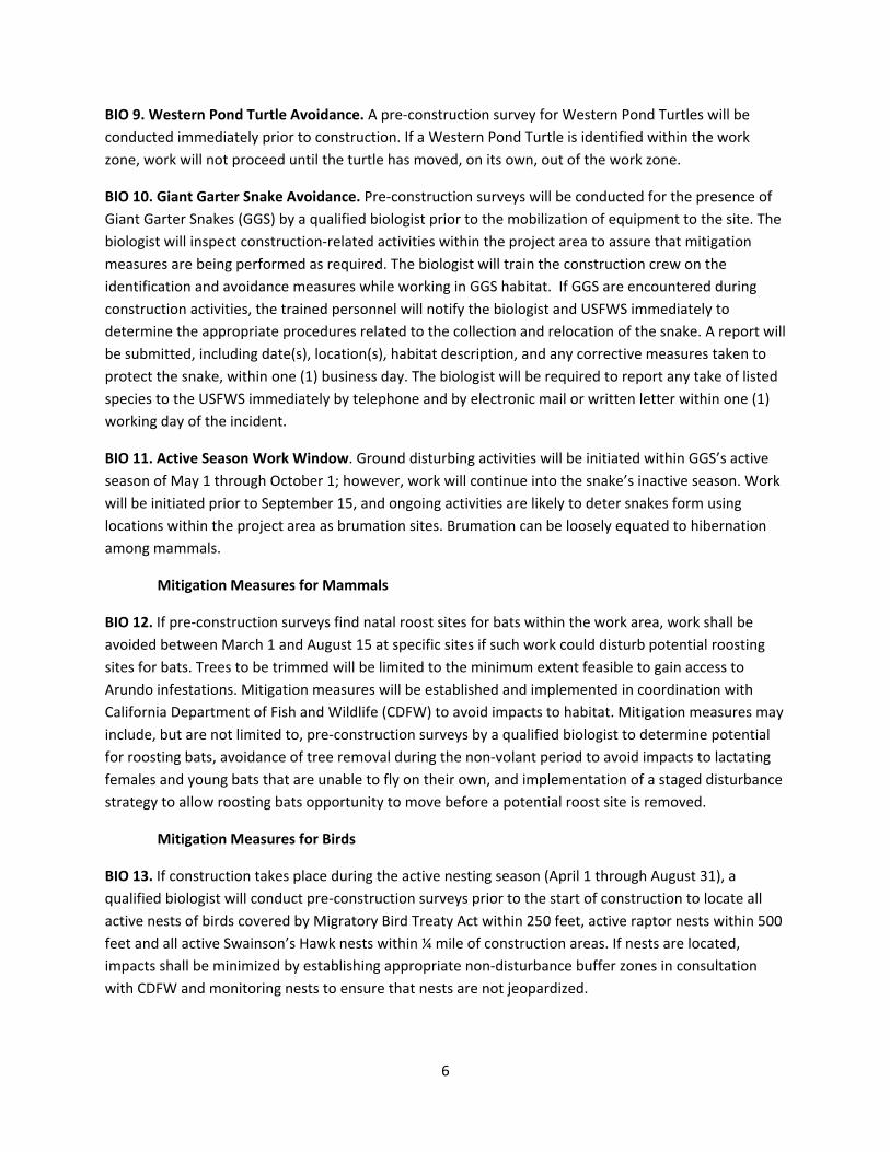
BIO 9. Western Pond Turtle Avoidance. A pre‐construction survey for Western Pond Turtles will be
conducted immediately prior to construction. If a Western Pond Turtle is identified within the work
zone, work will not proceed until the turtle has moved, on its own, out of the work zone.
BIO 10. Giant Garter Snake Avoidance. Pre‐construction surveys will be conducted for the presence of
Giant Garter Snakes (GGS) by a qualified biologist prior to the mobilization of equipment to the site. The
biologist will inspect construction‐related activities within the project area to assure that mitigation
measures are being performed as required. The biologist will train the construction crew on the
identification and avoidance measures while working in GGS habitat. If GGS are encountered during
construction activities, the trained personnel will notify the biologist and USFWS immediately to
determine the appropriate procedures related to the collection and relocation of the snake. A report will
be submitted, including date(s), location(s), habitat description, and any corrective measures taken to
protect the snake, within one (1) business day. The biologist will be required to report any take of listed
species to the USFWS immediately by telephone and by electronic mail or written letter within one (1)
working day of the incident.
BIO 11. Active Season Work Window. Ground disturbing activities will be initiated within GGS’s active
season of May 1 through October 1; however, work will continue into the snake’s inactive season. Work
will be initiated prior to September 15, and ongoing activities are likely to deter snakes form using
locations within the project area as brumation sites. Brumation can be loosely equated to hibernation
among mammals.
Mitigation Measures for Mammals
BIO 12. If pre‐construction surveys find natal roost sites for bats within the work area, work shall be
avoided between March 1 and August 15 at specific sites if such work could disturb potential roosting
sites for bats. Trees to be trimmed will be limited to the minimum extent feasible to gain access to
Arundo infestations. Mitigation measures will be established and implemented in coordination with
California Department of Fish and Wildlife (CDFW) to avoid impacts to habitat. Mitigation measures may
include, but are not limited to, pre‐construction surveys by a qualified biologist to determine potential
for roosting bats, avoidance of tree removal during the non‐volant period to avoid impacts to lactating
females and young bats that are unable to fly on their own, and implementation of a staged disturbance
strategy to allow roosting bats opportunity to move before a potential roost site is removed.
Mitigation Measures for Birds
BIO 13. If construction takes place during the active nesting season (April 1 through August 31), a
qualified biologist will conduct pre‐construction surveys prior to the start of construction to locate all
active nests of birds covered by Migratory Bird Treaty Act within 250 feet, active raptor nests within 500
feet and all active Swainson’s Hawk nests within ¼ mile of construction areas. If nests are located,
impacts shall be minimized by establishing appropriate non‐disturbance buffer zones in consultation
with CDFW and monitoring nests to ensure that nests are not jeopardized.
7
BIO 14. If Swainson’s Hawks are found nesting within ¼ mile of the proposed project, a qualified
biologist will conduct a risk assessment and consult CDFW to develop and implement appropriate
avoidance and minimization measures. This may include monitoring of nests by a qualified biologist and
suspension of work if Swainson’s Hawk nests are at risk of disturbance.
Mitigation Measures for Cultural Resources
CUL 1. If historical or unique archaeological or paleontological resources are incidentally discovered
during restoration activities, provisions will be made for a qualified archaeologist to immediately
evaluate the find. Work may continue on other parts of the project while evaluation and mitigation
takes place (CEQA Guidelines §15064.5 [f]). If the find is determined to be an historical or unique
archaeological or paleontological resource, time allotment sufficient to allow for implementation of
avoidance measures or appropriate mitigation must be available.
CUL 2. If human remains are found, such remains are subject to the provisions of California Public
Resources Health and Safety Code Section 7050.5‐7055. The requirements and procedures would be
implemented, including immediately stopping work in the vicinity of the find and notification of the
County Coroner. The process for notification of the California Native American Heritage Commission
(NAHC) and consultation with the individual(s) identified by the NAHC as the “most likely descendent” is
set forth in Section 5097.98 of the California Public Resources Code. Work can restart after the remains
have been investigated and appropriate recommendations have been made for the treatment and
disposition of the remains.
Mitigation Measures for Hydrology/Water Quality
WQ1. Activities will not be conducted on the edge of the streambank that would discharge sediment to
the waterway. Prepared soil will be pre‐irrigated to encourage native grass establishment prior to flood
season to prevent soil from being washed into the waterway if flood surface water elevations were to be
high enough to inundate the project site.
WQ2. If pre‐irrigation prior to flood season becomes unfeasible, then a straw mulch (either native grass
or rice) that is certified as weed‐free forage will be sprayed onto the site with a straw blower at the rate
of 20 bales/acre to provide increased soil structure and minimize rain drop erosion.
WQ3. Plant eradication activities near the streambank will be completed between June 15 and
November 1, or until the first major rainfall event.
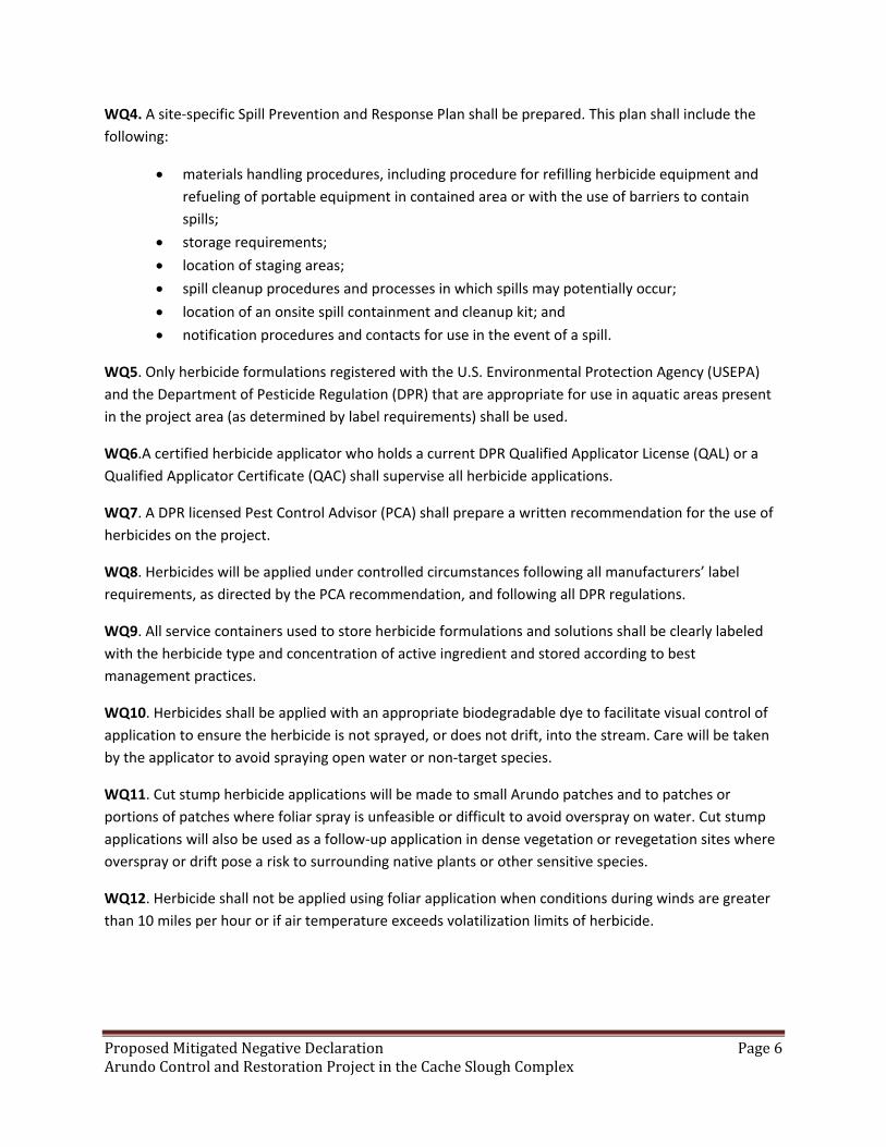
WQ4. A site‐specific Spill Prevention and Response Plan shall be prepared. This plan shall include the
following:
materials handling procedures, including procedure for refilling herbicide equipment and
refueling of portable equipment in contained area or with the use of barriers to contain
spills;
storage requirements;
8
location of staging areas;
spill cleanup procedures and processes in which spills may potentially occur;
location of an onsite spill containment and cleanup kit; and
notification procedures and contacts for use in the event of a spill.
WQ5. Only herbicide formulations registered with the U.S. Environmental Protection Agency (USEPA)
and the Department of Pesticide Regulation (DPR) that are appropriate for use in aquatic areas present
in the project area (as determined by label requirements) shall be used.
WQ6.A certified herbicide applicator who holds a current DPR Qualified Applicator License (QAL) or a
Qualified Applicator Certificate (QAC) shall supervise all herbicide applications.
WQ7. A DPR licensed Pest Control Advisor (PCA) shall prepare a written recommendation for the use of
herbicides on the project.
WQ8. Herbicides will be applied under controlled circumstances following all manufacturers’ label
requirements, as directed by the PCA recommendation, and following all DPR regulations.
WQ9. All service containers used to store herbicide formulations and solutions shall be clearly labeled as
required per regulations, including with the herbicide type and concentration of active ingredient, and
stored according to best management practices.
WQ10. Herbicides shall be applied with an appropriate biodegradable dye to facilitate visual control of
application to ensure the herbicide is not sprayed, or does not drift, into the stream. Care will be taken
by the applicator to avoid spraying open water or non‐target species.
WQ11. Cut stump herbicide applications will be made to small Arundo patches and to patches or
portions of patches where foliar spray is unfeasible or difficult to avoid overspray on water. Cut stump
applications will also be used as a follow‐up application in dense vegetation or revegetation sites where
overspray or drift pose a risk to surrounding native plants or other sensitive species.
WQ12. Herbicide shall not be applied using foliar application when conditions during winds are greater
than 10 miles per hour or if air temperature exceeds volatilization limits of herbicide.
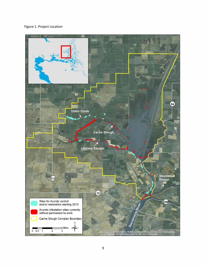
9
Figure 1. Project Location

10
Comment Letter #1
From: Allan, Jim D. [mailto:[email protected]] Sent: Thursday, June 25, 2015 4:31 PM To: Davis-Fadtke, Kristal M.@SSJDC Subject: Comments on Mitigated Neg Dec for Arundo Control and Restoration Project
I would like to respectfully submit the following comments and suggested modifications. I support the overall findings and the project with these minor issues addressed. Please note, all of the authorities cited are excerpted and are not intended to be referenced out of context.
Initial study
1. Comment-- Under Riparian Restoration, Plants, cuttings, and plugs should be sourced from a native plant nursery that is licensed by CDFA.
Authority cited:
FAC
6721. It is unlawful, for any person, except a person who is expressly exempt pursuant to Section 6742 or 6743, to sell any nursery stock unless such person holds a valid license which is issued pursuant to this chapter.
Mitigation Measures
BIO 1. Pre‐construction Survey.
2. Comment-- In this or some other mitigation section, sanitation of construction equipment should include pressure washing to clean metal or painted surface to remove soil borne pests and weed seeds before equipment is moved.
Also a grading permit should be obtained from Solano County Resource Management if more than a certain number of cubic yards of dirt are contemplated to be moved in the project.
Authority cited: Solano County Ordinance Code:
ARTICLE II. PROCEDURE
31-20 Grading and drainage permit requirement
(a) Except as exempted in sections 31-21 and 31-22 of this article, no person shall commence
or perform any of the following acts: change the topography of any land in such manner that
alters or interferes with existing water drainage; fill, close or divert any storm water drainage
channel or water course; grade, fill, excavate, or clear vegetation for any purpose without having
first obtained a grading and drainage permit from the Resource Management department. A

11
separate permit shall be required for each site and may cover both excavations and fills. When
immediate action by a person performing a public service is required to protect life and public
property from imminent danger, or to restore, repair, or maintain public works, levees, dikes,
utilities, or services destroyed or damaged by natural disaster, serious accident, or other types
of emergencies, work bay be commenced prior to obtaining a permit. Notification of any such
work must be given to the County on the next business day and an application for a grading
permit must be submitted within ten days.
BIO 8. Erosion and Sedimentation.
WQ2
If used, straw mulch should be certified as weed-free forage. A list of approved suppliers is at this link:
http://www.cal-ipc.org/ip/prevention/weedfreeforage.php
Authority cited
FAC
6341. If anything brought into any county or locality of the state from another county or locality within the state, or from any other state or foreign country, is found to be infested with the seed or propagule of any pest that is not of common occurrence in the county or locality into which the shipment is brought, the director or the commissioner shall notify the owner or bailee of such shipment to return it to the point from which the shipment was made.
WQ6.A certified herbicide applicator who holds a current DPR Qualified Applicator License (QAL) or a Qualified Applicator Certificate (QAC) shall supervise all herbicide applications.
3. Comment-- if the QAL/QAC is employed by a sub-contractor, they must be a licensed Pest Control Business with CDPR and that Business must register with the County Agricultural Commissioner before commencing work.
Authority: Food and Agriculture Code Sections 11701, 11732
WQ7. A DPR licensed Pest Control Advisor (PCA) shall prepare a written recommendation for the use of herbicides on the project.
4. Comment-- The pest Control Advisor must make a site evaluation and must register with the County Agricultural Commissioner before commencing work.
Authority: 3CCR 6556, Administrative case law LA Co. vs. Lofthus, Food and Agriculture Code Section 12002
12
WQ9. All service containers used to store herbicide formulations and solutions shall be clearly labeled with the herbicide type and concentration of active ingredient and stored according to best management practices
5. Comment-- Service Container labeling requires the signal word as well as the listed information- See regulation below:
3 CCR § 6678
§ 6678. Service Container Labeling.
Service containers, other than those used by a person engaged in the business of farming when the containers are used on the property the person is farming, shall be labeled with:
(a) the name and address of the person or firm responsible for the container;
(b) the identity of the pesticide in the container; and
(c) the word “Danger,” “Warning,” or “Caution” in accordance with the label on the original container.
Note: Authority cited: Sections 11456, 11502, 12781 and 12859, Food and Agricultural Code. Reference: Sections 11501 and 12859, Food and Agricultural Code.
13
Response to Comments
Comment Letter 1: Jim Allan, Solano County Agricultural Commissioner
Response to Comment 1
Thank you for your input. The Conservancy and any subcontractors on this project will only obtain plant
materials from native plant nurseries licensed by the California Department of Food and Agriculture.
Response to Comment 2
Language was added to Mitigation Measure BIO 4 stating that construction equipment will be pressure
washed to remove soil borne pests and weed seeds before equipment is moved.
Language was added to Mitigation Measures BIO 8 and WQ2 stating that straw will be certified as weed‐
free forage.
If necessary at restoration project sites, a grading permit will be obtained from Solano County.
Response to Comment 3
All herbicide applicators will be licensed with the California Department of Pesticide Regulation and will
register with the County Agricultural Commissioner before commencing work.
Response to Comment 4
The Pest Control Advisor will follow the guidelines specified in the Food and Agriculture Code Section
12002 and California Code of Regulation, Title 3, Section 6556.
Response to Comment 5
Language was added to Mitigation Measure WQ9 stating that service contains will be labeled per
regulation requirements.
14
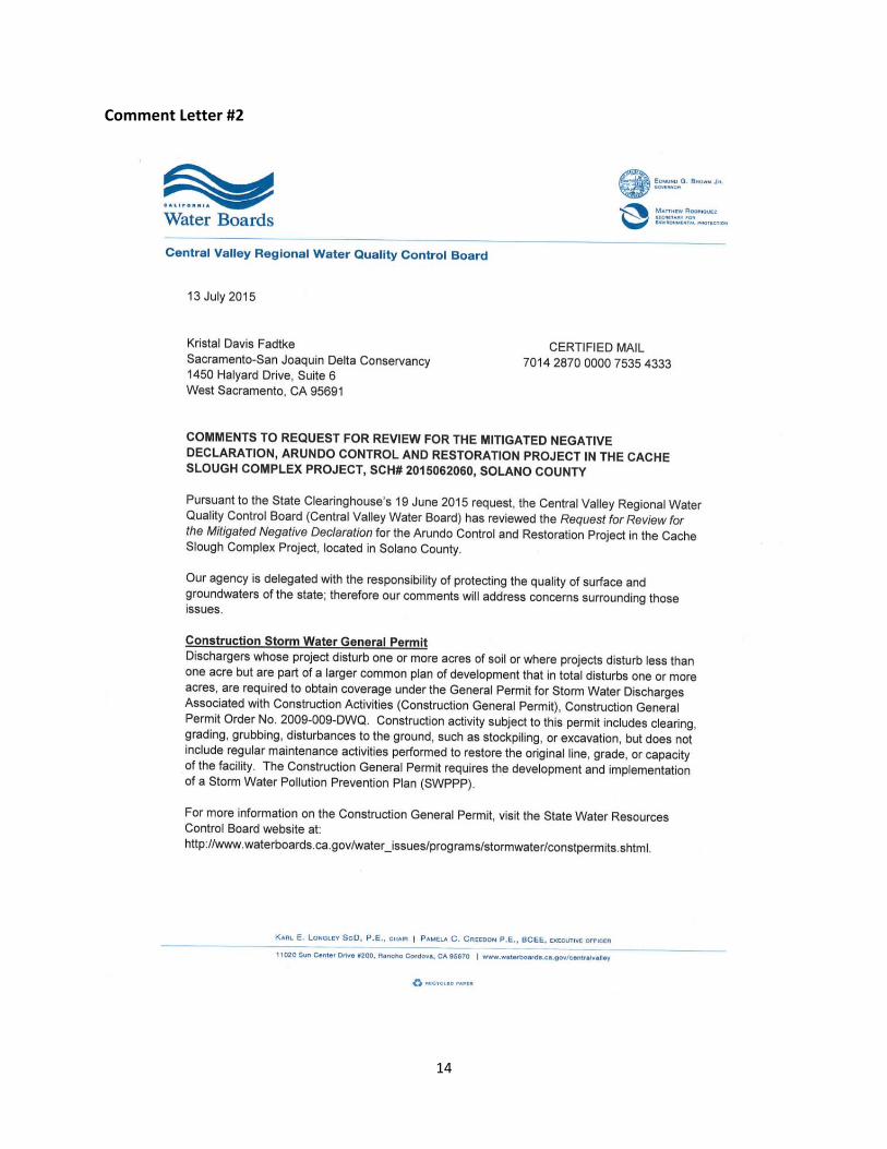
Comment Letter #2

15
16
17
18
Response to Comments
Comment Letter 2: Central Valley Regional Water Quality Control Board
Thank you for your input. For specific project sites where permission has been granted from the
landowner, it has been determined that only a Clean Water Act Section 404 permit and Clean Water Act
Section 401 permit will be needed at a restoration site. Other permits are either not applicable to the
project (Phase 1 and II Municipal Separate Storm Sewer System (MS4) permits, Industrial Storm Water
General permit, Low or Limited Threat General NPDES permit, and Regulatory Compliance for
Commercially Irrigated Agriculture) or work will be conducted in a manner and consistent with the
description in the Initial Study to avoid herbicides and sediment from entering the water. It is
anticipated that all Arundo control work will be done on land. If Arundo control work is done from the
water, the appropriate permit will be obtained to ensure the proper monitoring is conducted and water
quality is not substantially degraded and that no water quality standards or waste discharge
requirements are violated. If more than 1 acre of soil will be disturbed and exemptions do not apply to
the project, a Construction Storm Water General Permit will be obtained. A Waste Discharge
Requirement permit will be obtained if permission is granted to work on a site that is deemed by the US
Army Corps of Engineers to be only non‐jurisdictional waters of the State and project activities discharge
pollutants to surface waters.

19
Mitigation Monitoring and Reporting Program
The Mitigation and Monitoring Reporting Program (MMRP) is a CEQA required component of the
environmental process for a project. The results of the environmental analyses, including proposed
mitigation measures, are documented in the Mitigated Negative Declaration (MND) and associated
Initial Study. CEQA requires that agencies adopting MNDs take affirmative steps to determine that
approved mitigation measures are implemented subsequent to project approval.
As part of the CEQA environmental review procedures, Section 21081.6 requires a public agency to
adopt a monitoring and reporting program to ensure efficacy and enforceability of any mitigation
measures applied to the project. The lead agency must adopt an MMRP for mitigation measures
incorporated into the project as conditions of approval. The MMRP must be designed to ensure
compliance during project implementation.
Table 1 below is the MMRP. The table lists each of the mitigation measures from the MND and specifies
the agency responsible for implementation of the mitigation measures and the time period for the
mitigation measure.

20
Table 1. Mitigation Monitoring and Reporting Program
Mitigation Measures Implementing
Party Monitoring Agency Timing
Biological Resources
BIO 1. Pre‐construction Survey. Pre‐construction surveys for protected species will be performed no more than 48 hours prior to the mobilization of equipment to the site. The surveyor will look for special‐status species, evaluate the likelihood of occurrence in the habitat, and determine if additional biological monitoring is needed during restoration/work activities to ensure no individuals are harmed.
Contractor Delta Conservancy
Prior to construction
BIO 2. Protection of Listed Species. If a fully protected or listed animal species is encountered while performing work, all work shall be suspended until the fully protected or listed animal species has left the work area. The appropriate agencies shall be notified of all confirmed observations of any fully protected or listed species in or adjacent to any work area for the project. If a non‐listed special status species is encountered during construction activities, the trained personnel will notify the biologist and USFWS immediately to determine the appropriate procedures related to the avoidance or collection and relocation of the animal. The biologist will be required to report any take of listed species to the USFWS immediately by telephone and by electronic mail or written letter within one (1) working day of the incident.
Contractor Delta Conservancy
During weed control and restoration activities
BIO 3. Environmental Awareness Training. A Worker Environmental Awareness Training Program for personnel shall be conducted by a qualified biologist for all workers on restoration sites, including sub‐contractors, prior to the commencement of restoration activities. The program shall consist of a presentation made by a qualified biologist that includes information about the distribution and habitat needs of any special status species that may be present, legal protections for those species, penalties for violations and project‐specific protective measures included in this document.
Contractor Delta Conservancy
Prior to the commencement of restoration activities

21
Mitigation Measures Implementing
Party Monitoring Agency Timing
BIO 4. Native Habitat Areas Avoidance. Crews will avoid passing through (impacting) upland native habitat areas (they will use established roads, agricultural areas, entry points to river/riparian areas). The work area, including access and staging areas, shall be limited to the smallest possible area. Movement of personnel and equipment shall be limited to designated work zones, staging areas, and access roads. Construction equipment will be pressure washed to remove soil borne pests and weed seeds before equipment is moved. Staging areas shall be located in degraded areas and/or where the soil is already compacted, preferably near access points when site conditions allow. Access points shall be located at existing ramps/roads, or in areas that are already degraded. The project will minimize disturbance of vegetation near and on permanent and seasonal pools or streams, marshes and ponds, and shorelines with extensive emergent vegetation and/or weedy vegetation. Treatment of Arundo will occur only in Arundo‐occupied sites.
Contractor Delta Conservancy
During weed control and restoration activities
BIO 5. Native Plant Avoidance. A botanist will conduct pre‐restoration surveys for rare plants prior to restoration activities. If any are identified, the areas will be flagged. Plants will be avoided as much as possible. Those plants that may be impacted by project activities will be moved to an alternate site along the levee. Non‐native plant control methods will be used that minimize impacts to non‐target native vegetation. These methods include: preparing target plants for herbicide application by separating them from native vegetation, using highly qualified personnel who have experience treating non‐native plants in sensitive riparian habitat, and using herbicides that are approved for use which have no significant impacts on wildlife species.
Contractor Delta Conservancy
Prior to restoration activities
BIO 6. Fencing of Elderberry Shrubs. If any elderberry shrubs are identified at project sites, fencing and/or flagging will be used to identify exclusion areas around elderberry shrubs that will be avoided by personnel and equipment.
Contractor Delta Conservancy
Prior to weed control and restoration activities
22
Mitigation Measures Implementing
Party Monitoring Agency Timing
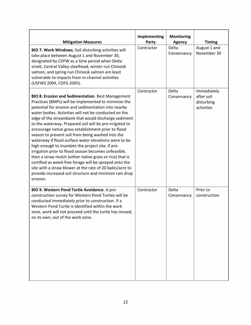
BIO 7. Work Windows. Soil disturbing activities will take place between August 1 and November 30, designated by CDFW as a time period when Delta smelt, Central Valley steelhead, winter‐run Chinook salmon, and spring‐run Chinook salmon are least vulnerable to impacts from in‐channel activities (USFWS 2004, CDFG 2005).
Contractor Delta Conservancy
August 1 and November 30
BIO 8. Erosion and Sedimentation. Best Management Practices (BMPs) will be implemented to minimize the potential for erosion and sedimentation into nearby water bodies. Activities will not be conducted on the edge of the streambank that would discharge sediment to the waterway. Prepared soil will be pre‐irrigated to encourage native grass establishment prior to flood season to prevent soil from being washed into the waterway if flood surface water elevations were to be high enough to inundate the project site. If pre‐irrigation prior to flood season becomes unfeasible, then a straw mulch (either native grass or rice) that is certified as weed‐free forage will be sprayed onto the site with a straw blower at the rate of 20 bales/acre to provide increased soil structure and minimize rain drop erosion.
Contractor Delta Conservancy
Immediately after soil disturbing activities
BIO 9. Western Pond Turtle Avoidance. A pre‐construction survey for Western Pond Turtles will be conducted immediately prior to construction. If a Western Pond Turtle is identified within the work zone, work will not proceed until the turtle has moved, on its own, out of the work zone.
Contractor Delta Conservancy
Prior to construction
23
Mitigation Measures Implementing
Party Monitoring Agency Timing
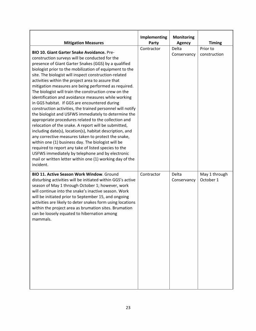
BIO 10. Giant Garter Snake Avoidance. Pre‐construction surveys will be conducted for the presence of Giant Garter Snakes (GGS) by a qualified biologist prior to the mobilization of equipment to the site. The biologist will inspect construction‐related activities within the project area to assure that mitigation measures are being performed as required. The biologist will train the construction crew on the identification and avoidance measures while working in GGS habitat. If GGS are encountered during construction activities, the trained personnel will notify the biologist and USFWS immediately to determine the appropriate procedures related to the collection and relocation of the snake. A report will be submitted, including date(s), location(s), habitat description, and any corrective measures taken to protect the snake, within one (1) business day. The biologist will be required to report any take of listed species to the USFWS immediately by telephone and by electronic mail or written letter within one (1) working day of the incident.
Contractor Delta Conservancy
Prior to construction
BIO 11. Active Season Work Window. Ground disturbing activities will be initiated within GGS’s active season of May 1 through October 1; however, work will continue into the snake’s inactive season. Work will be initiated prior to September 15, and ongoing activities are likely to deter snakes form using locations within the project area as brumation sites. Brumation can be loosely equated to hibernation among mammals.
Contractor Delta Conservancy
May 1 through October 1
24
Mitigation Measures Implementing
Party Monitoring Agency Timing
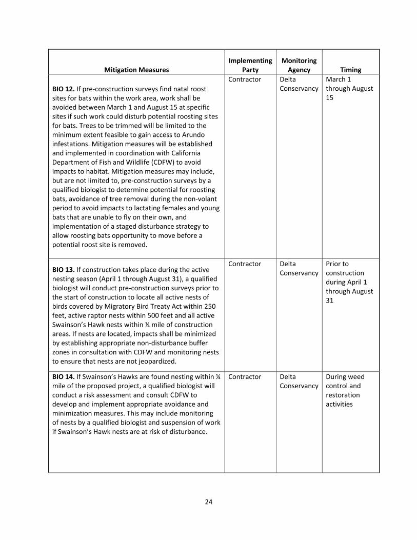
BIO 12. If pre‐construction surveys find natal roost sites for bats within the work area, work shall be avoided between March 1 and August 15 at specific sites if such work could disturb potential roosting sites for bats. Trees to be trimmed will be limited to the minimum extent feasible to gain access to Arundo infestations. Mitigation measures will be established and implemented in coordination with California Department of Fish and Wildlife (CDFW) to avoid impacts to habitat. Mitigation measures may include, but are not limited to, pre‐construction surveys by a qualified biologist to determine potential for roosting bats, avoidance of tree removal during the non‐volant period to avoid impacts to lactating females and young bats that are unable to fly on their own, and implementation of a staged disturbance strategy to allow roosting bats opportunity to move before a potential roost site is removed.
Contractor Delta Conservancy
March 1 through August 15
BIO 13. If construction takes place during the active nesting season (April 1 through August 31), a qualified biologist will conduct pre‐construction surveys prior to the start of construction to locate all active nests of birds covered by Migratory Bird Treaty Act within 250 feet, active raptor nests within 500 feet and all active Swainson’s Hawk nests within ¼ mile of construction areas. If nests are located, impacts shall be minimized by establishing appropriate non‐disturbance buffer zones in consultation with CDFW and monitoring nests to ensure that nests are not jeopardized.
Contractor Delta Conservancy
Prior to construction during April 1 through August 31
BIO 14. If Swainson’s Hawks are found nesting within ¼ mile of the proposed project, a qualified biologist will conduct a risk assessment and consult CDFW to develop and implement appropriate avoidance and minimization measures. This may include monitoring of nests by a qualified biologist and suspension of work if Swainson’s Hawk nests are at risk of disturbance.
Contractor Delta Conservancy
During weed control and restoration activities
25
Mitigation Measures Implementing
Party Monitoring Agency Timing
Cultural Resources
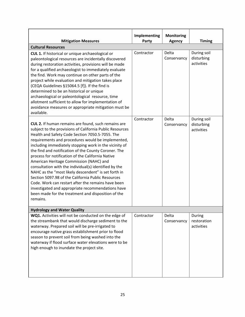
CUL 1. If historical or unique archaeological or paleontological resources are incidentally discovered during restoration activities, provisions will be made for a qualified archaeologist to immediately evaluate the find. Work may continue on other parts of the project while evaluation and mitigation takes place (CEQA Guidelines §15064.5 [f]). If the find is determined to be an historical or unique archaeological or paleontological resource, time allotment sufficient to allow for implementation of avoidance measures or appropriate mitigation must be available.
Contractor Delta Conservancy
During soil disturbing activities
CUL 2. If human remains are found, such remains are subject to the provisions of California Public Resources Health and Safety Code Section 7050.5‐7055. The requirements and procedures would be implemented, including immediately stopping work in the vicinity of the find and notification of the County Coroner. The process for notification of the California Native American Heritage Commission (NAHC) and consultation with the individual(s) identified by the NAHC as the “most likely descendent” is set forth in Section 5097.98 of the California Public Resources Code. Work can restart after the remains have been investigated and appropriate recommendations have been made for the treatment and disposition of the remains.
Contractor Delta Conservancy
During soil disturbing activities
Hydrology and Water Quality
WQ1. Activities will not be conducted on the edge of the streambank that would discharge sediment to the waterway. Prepared soil will be pre‐irrigated to encourage native grass establishment prior to flood season to prevent soil from being washed into the waterway if flood surface water elevations were to be high enough to inundate the project site.
Contractor Delta Conservancy
During restoration activities

26
Mitigation Measures Implementing
Party Monitoring Agency Timing
WQ2. If pre‐irrigation prior to flood season becomes unfeasible, then a straw mulch (either native grass or rice) that is certified as weed‐free forage will be sprayed onto the site with a straw blower at the rate of 20 bales/acre to provide increased soil structure and minimize rain drop erosion.
Contractor Delta Conservancy
After soil preparation and prior to flood season
WQ3. Plant eradication activities near the streambank will be completed between June 15 and November 1, or until the first major rainfall event.
Contractor Delta Conservancy
June 15 through November 1, or until first major rainfall event
WQ4. A site‐specific Spill Prevention and Response Plan shall be prepared. This plan shall include the following: • materials handling procedures, including procedure for refilling herbicide equipment and refueling of portable equipment in contained area or with the use of barriers to contain spills; • storage requirements; • location of staging areas; • spill cleanup procedures and processes in which spills may potentially occur; • location of an onsite spill containment and cleanup kit; and • notification procedures and contacts for use in the event of a spill.
Contractor Delta Conservancy
Prior to herbicide use
WQ5. Only herbicide formulations registered with the U.S. Environmental Protection Agency (USEPA) and the Department of Pesticide Regulation (DPR) that are appropriate for use in aquatic areas present in the project area (as determined by label requirements) shall be used.
Contractor Delta Conservancy
Prior to herbicide use
WQ6.A certified herbicide applicator who holds a current DPR Qualified Applicator License (QAL) or a Qualified Applicator Certificate (QAC) shall supervise all herbicide applications.
Contractor Delta Conservancy
Prior to herbicide use
WQ7. A DPR licensed Pest Control Advisor (PCA) shall prepare a written recommendation for the use of herbicides on the project.
Contractor Delta Conservancy
Prior to herbicide use
27
Mitigation Measures Implementing
Party Monitoring Agency Timing
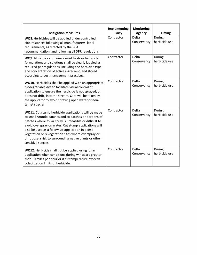
WQ8. Herbicides will be applied under controlled circumstances following all manufacturers’ label requirements, as directed by the PCA recommendation, and following all DPR regulations.
Contractor Delta Conservancy
During herbicide use
WQ9. All service containers used to store herbicide formulations and solutions shall be clearly labeled as required per regulations, including the herbicide type and concentration of active ingredient, and stored according to best management practices.
Contractor Delta Conservancy
During herbicide use
WQ10. Herbicides shall be applied with an appropriate biodegradable dye to facilitate visual control of application to ensure the herbicide is not sprayed, or does not drift, into the stream. Care will be taken by the applicator to avoid spraying open water or non‐target species.
Contractor Delta Conservancy
During herbicide use
WQ11. Cut stump herbicide applications will be made to small Arundo patches and to patches or portions of patches where foliar spray is unfeasible or difficult to avoid overspray on water. Cut stump applications will also be used as a follow‐up application in dense vegetation or revegetation sites where overspray or drift pose a risk to surrounding native plants or other sensitive species.
Contractor Delta Conservancy
During herbicide use
WQ12. Herbicide shall not be applied using foliar application when conditions during winds are greater than 10 miles per hour or if air temperature exceeds volatilization limits of herbicide.
Contractor Delta Conservancy
During herbicide use
Initial Study and
Proposed Mitigated Negative Declaration
For the
Arundo Control and Restoration Project
in the Cache Slough Complex
Prepared by:
Sacramento‐San Joaquin Delta Conservancy Lead Agency
June 2015

This page left intentionally blank.

Table of Contents
Proposed Mitigated Negative Declaration _________________________________________ 1
Initial Study __________________________________________________________________ 8
1 Introduction ___________________________________________________________________ 8
Background _______________________________________________________________________ 8 1.1
Lead Agency _______________________________________________________________________ 8 1.2
Supporting Environmental Studies _____________________________________________________ 8 1.3
2 Project Description _____________________________________________________________ 9
Project Location ____________________________________________________________________ 9 2.1
Project Need and Objective ___________________________________________________________ 9 2.2
Project Description _________________________________________________________________ 9 2.3
Proposed Equipment _______________________________________________________________ 15 2.4
Required Permits __________________________________________________________________ 15 2.5
Environmental Setting ______________________________________________________________ 16 2.6
3 Resources and Environmental Analysis ____________________________________________ 17
Environmental Factors Potentially Affected _____________________________________________ 17 3.1
Determination ____________________________________________________________________ 17 3.2
Aesthetics ________________________________________________________________________ 18 3.3
Agriculture and Forest Resources _____________________________________________________ 20 3.4
Air Quality _______________________________________________________________________ 22 3.5
Biological Resources _______________________________________________________________ 25 3.6
Cultural Resources _________________________________________________________________ 49 3.7
Geology and Soils __________________________________________________________________ 52 3.8
Greenhouse Gas Emissions __________________________________________________________ 54 3.9
Hazards and Hazardous Materials _____________________________________________________ 56 3.10
Hydrology and Water Quality ________________________________________________________ 59 3.11
Land Use and Planning ______________________________________________________________ 63 3.12
Mineral Resources _________________________________________________________________ 64 3.13
Noise ___________________________________________________________________________ 65 3.14
Population and Housing _____________________________________________________________ 67 3.15
Public Services ____________________________________________________________________ 68 3.16
Recreation _______________________________________________________________________ 69 3.17
Transportation and Traffic ___________________________________________________________ 70 3.18
Utilities and Service Systems _________________________________________________________ 72 3.19
Mandatory Findings of Significance____________________________________________________ 74 3.20
4 Document Preparation _________________________________________________________ 76
5 References ___________________________________________________________________ 77

List of Tables 1. Native Plants for Restoration ________________________________________________________ 14
2. Thresholds of Significance for Criteria Pollutants of Concern _______________________________ 23
3. Air Pollutant Emissions for the Project _________________________________________________ 23
4. Special Status Plant Species with the Potential to Occur Within the Project Area _______________ 28
5. Special Status Fish and Wildlife Species with the Potential to Occur Within the Project Area ______33
List of Figures
1. Project Location ___________________________________________________________________ 10

Acronyms and Abbreviations
BMPs Best Management Practices
CCR California Code of Regulations
CDFG California Department of Fish and Game
CDFW California Department of Fish and Wildlife
CEQA California Environmental Quality Act
CESA California Endangered Species Act
CNDDB California Natural Diversity Database
CNPS California Native Plant Society
CPRC California Public Resource Code
CO Carbon Monoxide
Conservancy Sacramento‐San Joaquin Delta Conservancy
CSC Cache Slough Complex
CVRWQCB Central Valley Regional Water Quality Control Board
Delta Sacramento‐San Joaquin Delta
DPR Department of Pesticide Regulation
EIR Environmental Impact Report
ESA Endangered Species Act
GGS Giant Gartersnake
GHG Greenhouse Gas
LOS Level of Service
MSL Mean Sea Level
NAHC Native American Heritage Commission
NHPA National Historic Preservation Act
NOx Nitrogen Oxides
PCA Pest Control Advisor
PM10 Particulate Matter less than 10 micrometers in diameter
PM2.5 Particulate Matter less than 2.5 micrometers in diameter
QAC Qualified Applicator Certificate
QAL Qualified Applicator Licence
ROG Reactive Organic Gases
SO2 Sulfur Dioxide
SR State Route
USEPA U.S. Environmental Protection Agency
USFWS United States Fish and Wildlife Service
YSAQMD Yolo‐Solano Air Quality Management District

ProposedMitigatedNegativeDeclaration Page1ArundoControlandRestorationProjectintheCacheSloughComplex
Proposed Mitigated Negative Declaration
Arundo Control and Restoration Project in the Cache Slough Complex
Lead Agency
Sacramento‐San Joaquin Delta Conservancy (Conservancy), 1450 Halyard Drive, Suite 6, West
Sacramento, CA 95691
Availability of Documents
The Initial Study for this Proposed Mitigated Negative Declaration is available for review for 30 days
from June 20, 2015. Questions or comments should be submitted no later than 5 p.m. on July 20, 2015
to:
Sacramento‐San Joaquin Delta Conservancy
Attn: Kristal Davis Fadtke
1450 Halyard Drive, Suite 6
West Sacramento, CA 95691
Kristal.Davis‐[email protected]
916‐375‐4994 (direct)
916‐375‐4948 (fax)
The document is available for review at the following locations:
Conservancy office, 1450 Halyard Drive, Suite 6, West Sacramento, CA 95691
Online at http://www.deltaconservancy.ca.gov/
Project Location
The project will take place within the primary Sacramento‐San Joaquin Delta (Delta) in the Cache Slough
Complex (CSC), as shown in Figure 1, in eastern Solano County, California. The project occurs within the
Dozier and Liberty Island U.S. Geological Survey 7.5‐minute quadrangles.
Project Description
With the goal of improving Delta ecosystems, the Conservancy proposes to control approximately 15
acres of the invasive species, Arundo donax (Arundo, giant reed), and restore native riparian habitat
where Arundo has been eradicated or at a nearby site.
Findings
The Initial Study has been prepared to determine if the project could have a significant effect on the
environment. Based on the Initial Study, it has been determined that the proposed project would not
have any significant effects on the environment after implementation of mitigation measures. The

ProposedMitigatedNegativeDeclaration Page2ArundoControlandRestorationProjectintheCacheSloughComplex
mitigation measures identified in the Initial Study and a Mitigation Monitoring and Reporting Plan will
be adopted to ensure compliance with the required mitigation measures. This conclusion is supported
by the following findings:
The proposed project would result in no impacts to agricultural resources, land use and
planning, mineral resources, noise, population and housing, public services and recreation.
The proposed project would result in less‐than‐significant impacts to aesthetics, air quality,
geology and soils, greenhouse gas emissions, hazards and hazardous materials, transportation
and traffic, and utilities and service systems.
With implementation of mitigation measures, the proposed project would have less‐than‐
significant impacts on biological resources, cultural resources, and hydrology and water quality.
Mitigation Measures
The following mitigation measures will be implemented by the Conservancy to avoid or minimize
potential environmental impacts. Implementation of these mitigation measures would reduce the
potential environmental impacts of the proposed project to a less‐than‐significant level.
Mitigation Measures for Biological Resources
General Biological Mitigation Measures
BIO 1. Pre‐construction Survey. Pre‐construction surveys for protected species will be performed no
more than 48 hours prior to the mobilization of equipment to the site. The surveyor will look for special‐
status species, evaluate the likelihood of occurrence in the habitat, and determine if additional
biological monitoring is needed during restoration/work activities to ensure no individuals are harmed.
BIO 2. Protection of Listed Species. If a fully protected or listed animal species is encountered while
performing work, all work shall be suspended until the fully protected or listed animal species has left
the work area. The appropriate agencies shall be notified of all confirmed observations of any fully
protected or listed species in or adjacent to any work area for the project. If a non‐listed special status
species is encountered during construction activities, the trained personnel will notify the biologist and
USFWS immediately to determine the appropriate procedures related to the avoidance or collection and
relocation of the animal. The biologist will be required to report any take of listed species to the USFWS
immediately by telephone and by electronic mail or written letter within one (1) working day of the
incident.
BIO 3. Environmental Awareness Training. A Worker Environmental Awareness Training Program for
personnel shall be conducted by a qualified biologist for all workers on restoration sites, including sub‐
contractors, prior to the commencement of restoration activities. The program shall consist of a
presentation made by a qualified biologist that includes information about the distribution and habitat
needs of any special status species that may be present, legal protections for those species, penalties for
violations and project‐specific protective measures included in this document.

ProposedMitigatedNegativeDeclaration Page3ArundoControlandRestorationProjectintheCacheSloughComplex
BIO 4. Native Habitat Areas Avoidance. Crews will avoid passing through (impacting) upland native
habitat areas (they will use established roads, agricultural areas, entry points to river/riparian areas).
The work area, including access and staging areas, shall be limited to the smallest possible area.
Movement of personnel and equipment shall be limited to designated work zones, staging areas, and
access roads. Staging areas shall be located in degraded areas and/or where the soil is already
compacted, preferably near access points when site conditions allow. Access points shall be located at
existing ramps/roads, or in areas that are already degraded. The project will minimize disturbance of
vegetation near and on permanent and seasonal pools or streams, marshes and ponds, and shorelines
with extensive emergent vegetation and/or weedy vegetation. Treatment of Arundo will occur only in
Arundo‐occupied sites.
Mitigation Measures for Plants
BIO 5. Native Plant Avoidance. A botanist will conduct pre‐restoration surveys for rare plants prior to
restoration activities. If any are identified, the areas will be flagged. Plants will be avoided as much as
possible. Those plants that may be impacted by project activities will be moved to an alternate site
along the levee.
Non‐native plant control methods will be used that minimize impacts to non‐target native vegetation.
These methods include: preparing target plants for herbicide application by separating them from native
vegetation, using highly qualified personnel who have experience treating non‐native plants in sensitive
riparian habitat, and using herbicides that are approved for use which have no significant impacts on
wildlife species.
Mitigation Measures for Invertebrates
BIO 6. Fencing of Elderberry Shrubs. If any elderberry shrubs are identified at project sites, fencing
and/or flagging will be used to identify exclusion areas around elderberry shrubs that will be avoided by
personnel and equipment.
Mitigation Measures for Fish
BIO 7. Work Windows. Soil disturbing activities will take place between August 1 and November 30,
designated by CDFW as a time period when Delta smelt, Central Valley steelhead, winter‐run Chinook
salmon, and spring‐run Chinook salmon are least vulnerable to impacts from in‐channel activities
(USFWS 2004, CDFG 2005).
Mitigation Measures for Amphibians and Reptiles
BIO 8. Erosion and Sedimentation. Best Management Practices (BMPs) will be implemented to minimize
the potential for erosion and sedimentation into nearby water bodies. Activities will not be conducted
on the edge of the streambank that would discharge sediment to the waterway. Prepared soil will be
pre‐irrigated to encourage native grass establishment prior to flood season to prevent soil from being
washed into the waterway if flood surface water elevations were to be high enough to inundate the

ProposedMitigatedNegativeDeclaration Page4ArundoControlandRestorationProjectintheCacheSloughComplex
project site. If pre‐irrigation prior to flood season becomes unfeasible, then a straw mulch (either native
grass or rice) will be sprayed onto the site with a straw blower at the rate of 20 bales/acre to provide
increased soil structure and minimize rain drop erosion.
BIO 9. Western Pond Turtle Avoidance. A pre‐construction survey for Western Pond Turtles will be
conducted immediately prior to construction. If a Western Pond Turtle is identified within the work
zone, work will not proceed until the turtle has moved, on its own, out of the work zone.
BIO 10. Giant Garter Snake Avoidance. Pre‐construction surveys will be conducted for the presence of
Giant Garter Snakes (GGS) by a qualified biologist prior to the mobilization of equipment to the site. The
biologist will inspect construction‐related activities within the project area to assure that mitigation
measures are being performed as required. The biologist will train the construction crew on the
identification and avoidance measures while working in GGS habitat. If GGS are encountered during
construction activities, the trained personnel will notify the biologist and USFWS immediately to
determine the appropriate procedures related to the collection and relocation of the snake. A report will
be submitted, including date(s), location(s), habitat description, and any corrective measures taken to
protect the snake, within one (1) business day. The biologist will be required to report any take of listed
species to the USFWS immediately by telephone and by electronic mail or written letter within one (1)
working day of the incident.
BIO 11. Active Season Work Window. Ground disturbing activities will be initiated within GGS’s active
season of May 1 through October 1; however, work will continue into the snake’s inactive season. Work
will be initiated prior to September 15, and ongoing activities are likely to deter snakes form using
locations within the project area as brumation sites. Brumation can be loosely equated to hibernation
among mammals.
Mitigation Measures for Mammals
BIO 12. If pre‐construction surveys find natal roost sites for bats within the work area, work shall be
avoided between March 1 and August 15 at specific sites if such work could disturb potential roosting
sites for bats. Trees to be trimmed will be limited to the minimum extent feasible to gain access to
Arundo infestations. Mitigation measures will be established and implemented in coordination with
California Department of Fish and Wildlife (CDFW) to avoid impacts to habitat. Mitigation measures may
include, but are not limited to, pre‐construction surveys by a qualified biologist to determine potential
for roosting bats, avoidance of tree removal during the non‐volant period to avoid impacts to lactating
females and young bats that are unable to fly on their own, and implementation of a staged disturbance
strategy to allow roosting bats opportunity to move before a potential roost site is removed.
Mitigation Measures for Birds
BIO 13. If construction takes place during the active nesting season (April 1 through August 31), a
qualified biologist will conduct pre‐construction surveys prior to the start of construction to locate all
active nests of birds covered by Migratory Bird Treaty Act within 250 feet, active raptor nests within 500

ProposedMitigatedNegativeDeclaration Page5ArundoControlandRestorationProjectintheCacheSloughComplex
feet and all active Swainson’s Hawk nests within ¼ mile of construction areas. If nests are located,
impacts shall be minimized by establishing appropriate non‐disturbance buffer zones in consultation
with CDFW and monitoring nests to ensure that nests are not jeopardized.
BIO 14. If Swainson’s Hawks are found nesting within ¼ mile of the proposed project, a qualified
biologist will conduct a risk assessment and consult CDFW to develop and implement appropriate
avoidance and minimization measures. This may include monitoring of nests by a qualified biologist and
suspension of work if Swainson’s Hawk nests are at risk of disturbance.
Mitigation Measures for Cultural Resources
CUL 1. If historical or unique archaeological or paleontological resources are incidentally discovered
during restoration activities, provisions will be made for a qualified archaeologist to immediately
evaluate the find. Work may continue on other parts of the project while evaluation and mitigation
takes place (CEQA Guidelines §15064.5 [f]). If the find is determined to be an historical or unique
archaeological or paleontological resource, time allotment sufficient to allow for implementation of
avoidance measures or appropriate mitigation must be available.
CUL 2. If human remains are found, such remains are subject to the provisions of California Public
Resources Health and Safety Code Section 7050.5‐7055. The requirements and procedures would be
implemented, including immediately stopping work in the vicinity of the find and notification of the
County Coroner. The process for notification of the California Native American Heritage Commission
(NAHC) and consultation with the individual(s) identified by the NAHC as the “most likely descendent” is
set forth in Section 5097.98 of the California Public Resources Code. Work can restart after the remains
have been investigated and appropriate recommendations have been made for the treatment and
disposition of the remains.
Mitigation Measures for Hydrology/Water Quality
WQ1. Activities will not be conducted on the edge of the streambank that would discharge sediment to
the waterway. Prepared soil will be pre‐irrigated to encourage native grass establishment prior to flood
season to prevent soil from being washed into the waterway if flood surface water elevations were to be
high enough to inundate the project site.
WQ2. If pre‐irrigation prior to flood season becomes unfeasible, then a straw mulch (either native grass
or rice) will be sprayed onto the site with a straw blower at the rate of 20 bales/acre to provide
increased soil structure and minimize rain drop erosion.
WQ3. Plant eradication activities near the streambank will be completed between June 15 and
November 1, or until the first major rainfall event.
ProposedMitigatedNegativeDeclaration Page6ArundoControlandRestorationProjectintheCacheSloughComplex
WQ4. A site‐specific Spill Prevention and Response Plan shall be prepared. This plan shall include the
following:
materials handling procedures, including procedure for refilling herbicide equipment and
refueling of portable equipment in contained area or with the use of barriers to contain
spills;
storage requirements;
location of staging areas;
spill cleanup procedures and processes in which spills may potentially occur;
location of an onsite spill containment and cleanup kit; and
notification procedures and contacts for use in the event of a spill.
WQ5. Only herbicide formulations registered with the U.S. Environmental Protection Agency (USEPA)
and the Department of Pesticide Regulation (DPR) that are appropriate for use in aquatic areas present
in the project area (as determined by label requirements) shall be used.
WQ6.A certified herbicide applicator who holds a current DPR Qualified Applicator License (QAL) or a
Qualified Applicator Certificate (QAC) shall supervise all herbicide applications.
WQ7. A DPR licensed Pest Control Advisor (PCA) shall prepare a written recommendation for the use of
herbicides on the project.
WQ8. Herbicides will be applied under controlled circumstances following all manufacturers’ label
requirements, as directed by the PCA recommendation, and following all DPR regulations.
WQ9. All service containers used to store herbicide formulations and solutions shall be clearly labeled
with the herbicide type and concentration of active ingredient and stored according to best
management practices.
WQ10. Herbicides shall be applied with an appropriate biodegradable dye to facilitate visual control of
application to ensure the herbicide is not sprayed, or does not drift, into the stream. Care will be taken
by the applicator to avoid spraying open water or non‐target species.
WQ11. Cut stump herbicide applications will be made to small Arundo patches and to patches or
portions of patches where foliar spray is unfeasible or difficult to avoid overspray on water. Cut stump
applications will also be used as a follow‐up application in dense vegetation or revegetation sites where
overspray or drift pose a risk to surrounding native plants or other sensitive species.
WQ12. Herbicide shall not be applied using foliar application when conditions during winds are greater
than 10 miles per hour or if air temperature exceeds volatilization limits of herbicide.

InitialStudy Page8ArundoControlandRestorationProjectintheCacheSloughComplex
InitialStudy
1 Introduction
Background1.1
This document is an Initial Study that provides an analysis of the Arundo Control and Restoration
Project. This document has been prepared in accordance with California Environmental Quality Act
(CEQA), Public Resources Code §2100 et seq., and the State CEQA Guidelines, Title 14 California Code of
Regulations (CCR) Section 15000 et seq.
The purpose of this Initial Study is to: (1) determine whether project implementation would result in
potential significant or significant effects to the environment, and (2) incorporate mitigation measures
into the project design, as necessary, to eliminate the project’s potential significant or significant effects
or reduce them to a less‐than‐significant level.
LeadAgency1.2
As specified in CEQA Guidelines Section 15367, the lead agency for CEQA compliance is the public
agency that has the principal responsibilities for carrying out or approving the project. The Conservancy
has principal responsibility for carrying out the proposed project and is therefore the CEQA lead agency
for this Initial Study.
SupportingEnvironmentalStudies1.3
Environmental studies conducted for the project include: 1) a biological assessment for fisheries
(National Marine Fisheries Service jurisdiction), 2) a biological assessment for other species (U.S. Fish
and Wildlife Service jurisdiction), and 3) a cultural records report. These environmental reports are
available upon request during normal operating hours at the Conservancy, 1450 Halyard Drive, Suite 6,
West Sacramento, CA 95691 or by contacting Kristal Davis Fadtke at Kristal.Davis‐
[email protected] , 916‐375‐4994.
InitialStudy Page9ArundoControlandRestorationProjectintheCacheSloughComplex
2 ProjectDescription
ProjectLocation2.1
The project will take place in the CSC, in Solano County, in the northwest reach of the Delta, as shown in
Figure 1. This project contains multiple sites. The project sites are located with the Liberty Island and
Dozier U.S. Geological Survey 7.5‐minute quadrangle.
ProjectNeedandObjective2.2
Arundo is an invasive species introduced to California two to three centuries ago for a variety of uses. It
has become widespread in California and is devastating to native species. Arundo out‐competes native
riparian plant species, consumes much more water than native vegetation, does not provide nesting or
foraging habitat needed for wildlife species, increases bank erosion during flood events and increases
fire severity. The objective of the project is to eradicate Arundo and restore native riparian habitat.
ProjectDescription2.3
This projects aims to control Arundo in the CSC and, where feasible, establish a diverse mix of native
trees, shrubs, grasses and forbs that are adapted to the local hydrology and soil conditions for the
benefit of a wide assortment of local wildlife species. This may include restoring riparian areas adjacent
to Arundo eradication sites. Figure 1 shows the location of Arundo infestations in the CSC. While the
project aims to control Arundo throughout the CSC, permission to work is needed from the landowner
at each potential project site and it may not be obtained for every site shown in Figure 1. Sites where
landowner permission has been obtained and Arundo control work and/or restoration is scheduled to
begin in the summer of 2015 are also identified in Figure 1. The main components of the project are as
follows:
Arundo Eradication
Pre‐treatment Preparation and Precautions: Prior to application, a biologist or trained crew member will
inspect application site and look for any wildlife use within the target Arundo patch. If nesting birds are
found, the use will be flagged and noted and patch will be avoided until after wildlife use. Applicator will
also inspect site for complete preparation of vegetation to maximize efficiency of application and
minimize risk to desirable species.
After inspection and prior to application, targeted Arundo sites will be prepared by clearing a perimeter
around patches to facilitate access and minimize non‐target applications. Arundo canes will be
separated from native vegetation and manipulated to minimize overspray and avoid damaging desirable
vegetation or contact with water. Application crew will prune desirable woody vegetation that is mixed
with Arundo to avoid herbicide damage. Non‐dormant desired understory vegetation will be mowed or
covered with tarps to avoid overspray damage.
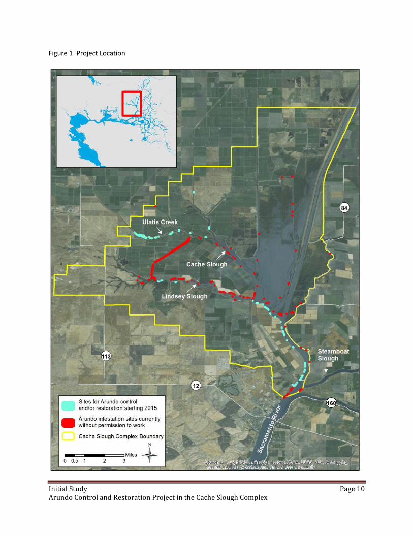
InitialStudy Page10ArundoControlandRestorationProjectintheCacheSloughComplex
Figure 1. Project Location
InitialStudy Page11ArundoControlandRestorationProjectintheCacheSloughComplex
Foliar Application: A combination of backpack sprayer and power sprayer will be used to apply
aquatically approved formulations of herbicide and surfactant (recommended combination of
glyphosate and/or imazapyr, and appropriate surfactant). Foliar applications will be made according to
PCA recommendations for specific formulations. Typical glyphosate formulations will be applied "spray
to wet" to achieve a minimum of 90% coverage of green portions of the target species. Applications will
be a directed spray from all sides of Arundo infestations and from above as equipment and access
allows. Where accessible, applicator will use a ladder or mechanized boom lift to apply from above to
minimize drift, avoid spraying toward water, and to attain better coverage. In sites with limited access or
heavily mixed vegetation, applicator will use hand tools specifically developed to concentrate and bend
Arundo canes to minimize upward spray motion and reduce application rate. Spray equipment will
utilize lowest volume possible and spray tips to control droplet size and reduce drift. If appropriate, an
anti‐drift additive will be added to the spray mix.
Spraying will take place in the late summer and fall when translocation of herbicide is most effective for
Arundo and less likely to harm annuals and herbaceous perennial native plants and other sensitive
species that have completed their life cycle for the season.
Cut Stump Application: Cut stump herbicide applications will be made to small Arundo patches and to
patches or portions of patches where foliar spray is unfeasible or difficult to avoid overspray on water.
Cut stump applications will also be used as a follow‐up application in dense vegetation or revegetation
sites where overspray or drift pose a risk to surrounding native plants or other sensitive species. Cut
stump applications will be made to freshly cut Arundo stumps using a sealed and labeled applicator
bottle.
Biomass: Dead Arundo biomass will remain in place after spraying. It is critically important to leave the
dead and dying Arundo canes intact over the winter to ensure complete translocation of herbicide for
maximum efficacy. The dead Arundo will decay over the course of a few years and the dead rhizomes
will provide transitional bank stability until native vegetation establishes on the bank. In the rare case
that the Arundo poses a fire hazard to an adjacent structure, the canes can be removed before the
following fire season. Cut canes must be disposed of or piled off channel to avoid mobilization in a flood
event.
Effective control of target plants is required prior to re‐vegetation to avoid situations where re‐
treatments would harm a significant number of plantings. For areas that are treated first and then
followed by biomass reduction, planting can occur immediately if conditions are suitable. Areas that
have biomass reduction first and then have re‐growth treated in multiple cycles, will typically not be
planted with natives until after the second year of treatments.
Riparian Restoration
Local Plant Propagation: A majority of the native plants for the program will be grown from locally
derived seed stock and cuttings within the watershed starting fall 2014 and continuing through the
period of the project. A list of potential native plants to be used can be found in Table 1.
InitialStudy Page12ArundoControlandRestorationProjectintheCacheSloughComplex
Site Preparation and Infrastructure: Project sites will be prepared for seeding grasses, planting trees, and
plug planting grasses, sedges and rushes by using accepted agricultural practices to achieve the best
conditions for successful habitat creation and restoration. Site preparation practices include, but are not
limited to, grazing, spraying herbicides (both selective and non‐selective), disking, mowing, brush
clearing, weed whacking, burning and pre‐irrigation. Infrastructure improvements such as exclusionary
livestock fence (both barbed wire and electric), livestock troughs, and shallow livestock wells maybe
installed to exclude livestock from waterways and provide alternative and /or improved sources of clean
water for livestock. Irrigation systems, including PVC, drip line and aluminum pipe sprinklers will be
installed where necessary to pre‐irrigate site for weed control and site preparation and to irrigate newly
installed vegetation for at least two years to ensure maximum survival.
Understory Establishment: Native grass seeding will be accomplished by broadcasting with electric quad
mounted seeders and hand seeders. Sites will be harrowed and smoothed with various chain
implements prior to and after seeding. Larger sites will be installed by drill seeding with a tractor.
Transplants or plugs of sedges, rushes, grasses and forbs will be planted on one to three foot centers on
selected sites to achieve a diverse and secure understory. Plug plants will also be used to vegetate
waterlines and areas where a proper seed bed could not be achieved. Installation will be executed by
hand with dibble tools and trays of transplants. Plug planting sites may be sprayed prior to planting to
minimize weedy competition.
Tree and Shrub Establishment: Tree and shrub planting will be accomplished with the use of container
stock, direct seeding and cuttings. Woody plants will be installed on roughly 10 ‐20 foot centers and be
situated in such a manner that allows for effective weed management techniques to be executed with
the appropriate equipment for the site. Restoration design will emphasize a diverse canopy structure
and will combine a diverse mix of local native trees, shrubs, sub‐shrubs and low growing herbaceous
forbs where possible. Installation will be executed primarily by hand with occasional use of small
augering equipment via hand augers or small Bobcat tractors. Most woody plant materials will be
protected with tree or shrub shelters. Plant shelters will be omitted if chance of floods or vandalism by
the public is high at the project site.
Irrigation Installation: Trees and shrubs that are not planted in the wet or moist zone along the stream
banks will be irrigated for at least two seasons to ensure maximum survival. The water source for
irrigation activities will be existing wells, established irrigation systems near the planting site or water
that will be pumped from the nearest farm irrigation ditch using high pressure water pumps. In addition,
sprinkler pipe will be utilized when necessary to promote understory establishment in the event that
rain patterns are erratic or absent in a given season. Polyethylene drip line will be the primary mode of
irrigation for woody plant species to minimize weed growth and maximize water use efficiency. Systems
are typically run every 8‐15 days (dependent on local site conditions of slope, soil type, etc.) The
strategy behind the frequency and duration of irrigation events will be to drive root growth of the native
vegetation to reach deeper soil moisture.
InitialStudy Page13ArundoControlandRestorationProjectintheCacheSloughComplex
Site Maintenance and Monitoring: Sites will be managed and monitored for up to three years. On‐going
maintainence activities of the sites will include replanting and vegetation management practices such as
mowing, herbicide treatments (selective and non‐selective), and irrigation to ensure maximum survival
of all installed native vegetation. All labels will be followed for herbicide application and use
restrictions. Mowing and brush cutting activities will be timed to balance the need to both effectively
reducing mature seed set of target weeds while minimizing impact to breeding wildlife within the site
understory. Small quad pulled mowers as well as tractor mowers will be utilized in the larger areas while
smaller “un‐drivable” sites will be brush‐cut with hand tools.
Monitoring: Monitoring of the sites will consist of photo monitoring at at least two designated points
per site and will be executed biannually (Spring and Fall). Replanting will occur as needed to maintain a
minimum of 75% woody plant survival throughout all project sites. Monitoring for plant survival will be
executed at each restoration site once each season in the fall to provide information how individual
species are performing and enable informed adjustments to be made in weed control treatments or
replanting strategy.

InitialStudy Page14ArundoControlandRestorationProjectintheCacheSloughComplex
Table 1. Native Plants for Restoration
Latin name Common name
Grasses, Rushes and Sedges
Carex barbarae Santa Barbara Sedge
Distichlis spicata Salt Grass
Elymus glaucus Blue Wild Rye
Elymus trachycaulus Slender Wheatgrass
Hordeum brachyantherum Meadow Barley
Juncus balticus Baltic Rush
Leymus triticoides Creeping Wildrye
Nassella pulchra Purple Needlegrass
Trees, Shrubs, Vines and Forbs
Acer negundo Box Elder
Achillea millefolium Yarrow
Alnus rhombiforlia White Alder
Artemisia douglasiana Mugwort
Asclepias ericarpa Broadleaf Milkweed
Asclepias fasicularis Narrowleaf Milkweed
Atriplex lentiformus Quail Bush
Baccharis pilularis Coyote Bush
Baccharis salicifolia Mule Fat
Cephalanthus occidentalis Button Willow
Cornus sericea American Dogwood
Eschscholzia californica California Poppy
Fraxinus latifolia Oregon Ash
Grendelia camporum Gum Plant
Hibiscus lasiocarpus Rose Mallow
Hibiscus rosa‐sinensis Hibiscus
Lotus pershianus Spanish Clover
Lupinus succulentus Arroyo Lupine
Marah oreganus Wild cucumber
Platanus racemosa Western Sycamore
Populus Cottonwood
Primrose California Evening Primrose
Quercus lobata Valley Oak
Rhubis californica California Blackberry
Rosa californica California Wild Rose
Salix goodingii Black Willow
Salix laevigata Red Willow
Salix lasiolepis Arroyo Willow
Vitis californica California Wild Grape

InitialStudy Page15ArundoControlandRestorationProjectintheCacheSloughComplex
ProposedEquipment2.4
Diesel Water Pump on a trailer for powering temporary sprinkler irrigation system
Dozer for smoothing out spoil piles
Land planer for smoothing planting soil surface
Quad and trailer boom sprayers for foliar herbicide application/weed control
Truck mounted power sprayer for foliar herbicide application/weed control
Rubber track boom lift
Tractor with assorted implements: drill seeder, two directional disc and ring roller for seed bed
preparation, rotary mower, slip plow for burying dripline, auger for drilling plant holes
Small trencher for irrigation pipe install
Straw blower for spreading erosion control material
Bobcat with various implements: bucket for collecting small trash and debris, auger for plant
hole drilling
Backpack sprayers and hand brush‐cutting tools and chainsaws for small scale vegetation
clearing
Chipper for disposing of biomass waste and prunings
RequiredPermits2.5
Several regulatory agencies have jurisdiction over riparian areas in the CSC. The Conservancy expects to
obtain the following permits and agreements from state and federal agencies (listed below) with
jurisdiction over the project activities and locations. The permits needed will depend on the specifics at
each project site.
Regulatory Agency Permit or Agreement
California Department of Fish and Wildlife
California Fish and Wildlife Code section 1602, Streambed Alteration Agreement. Incorporates compliance with the California Endangered Species Act
Central Valley Flood Protection Board
Encroachment Permit
Army Corps of Engineers Section 404 Permit
State Water Resources Control Board
Section 401 Water Quality Certification
U.S. Fish and Wildlife Service Letter of Concurrence for species (terrestrial and freshwater aquatic) that are protected under the Endangered Species Act
National Oceanic and Atmospheric Administration,
Fisheries
Letter of Concurrence for species (anadromous fish) that are protected under the Endangered Species Act

InitialStudy Page16ArundoControlandRestorationProjectintheCacheSloughComplex
EnvironmentalSetting2.6
The project area is located the Cache Slough Complex where the landuse is predominantly agricultural.
Potential project sites are on the waterside of levees along the channels and sloughs of a tidally
influenced system. Many of the levees have been engineered with rock slope protection, but are also
lined with riparian vegetation.
The project area is within the legal Delta boundary of the Sacramento San Joaquin Delta. It lies within
the southwestern Sacramento Valley subregion of the Great Central Valley of the California Floristic
Province (Hickman 2012). The elevation ranges from approximately 7 feet below mean sea level (MSL)
to 10 feet above MSL. The climate of the project region is characterized by hot, dry summers and cool,
moist winters. The average annual precipitation is 20 inches. Some additional precipitation originates
from ground fog, known regionally as tule fog, during late fall and winter after the first significant rainfall
when atmospheric inversions generate fog.
The prevailing wind in the project vicinity is from the west and southwest. In the summer months, wind
is generally strong from the southwest, and wind speeds are higher and more constant. In winter, wind
direction is more variable and wind speeds are significantly lower.
The proposed activities are located near the center of California’s Central Valley, which is drained by the
Sacramento River from the north, the American River from the east, and the San Joaquin River from the
south. The project area drains into Cache Slough.
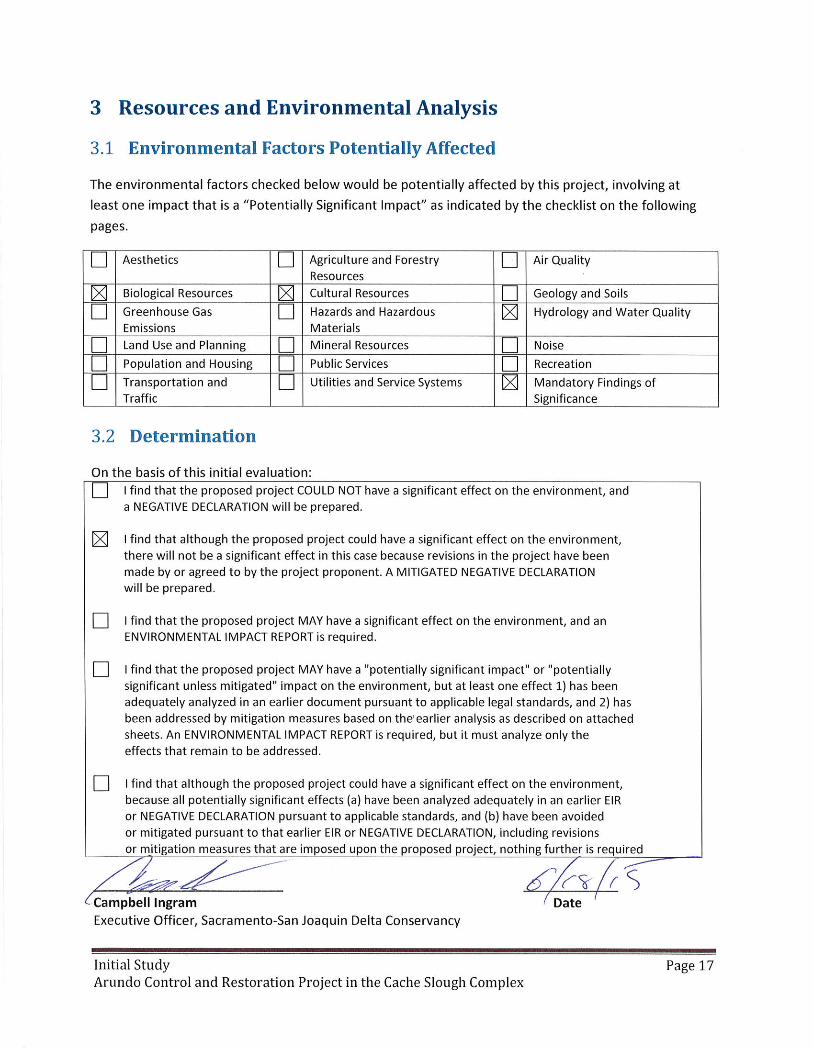

InitialStudy Page18ArundoControlandRestorationProjectintheCacheSloughComplex
Aesthetics3.3
Potentially Significant Impact
Less Than Significant with
Mitigation
Less Than Significant Impact
No Impact
Would the project:
a) Have a substantial adverse effect on a scenic vista?
b) Substantially damage scenic resources, including, but not limited to, trees, rock outcroppings, and historic buildings within a state scenic highway?
c) Substantially degrade the existing visual character or quality of the site and its surroundings?
d) Create a new source of substantial light or glare which would adversely affect day or nighttime views in the area?
Environmental Setting
Visual resources consist of the natural and manmade features that give a particular environment its
aesthetic qualities. The primary areas of concern generally are associated with changes to prominent
topographic features, changes in the character of an area with high visual sensitivity, removal of
vegetation, or blockage of public views of a visually sensitive landscape.
Potential project sites are along levees. Most of the adjacent area is agricultural. The scenic character of
the project area is defined mostly by riparian habitat along the banks of the sloughs and agricultural
areas visible from the levee roads. There are no State‐designated visual resources within or near the
potential project sites.
Discussion
a) Have a substantial adverse effect on a scenic vista?
Less than Significant Impact. A scenic vista can be affected by directly reducing the scenic quality of the
vista or by blocking views of the scenic resource. The project will not result in cumulative impacts on
scenic vistas because the project would remove stands of Arundo and other target non‐native plants
from riverine areas that have limited public access. Changes in vegetation composition are not likely to
significantly alter the view.
b) Substantially damage scenic resources, including, but not limited to, trees, rock outcroppings, and
historic buildings within a state scenic highway?
Less than Significant Impact. The project will control Arundo within Cache Slough Complex, however,
visual impacts are expected to be temporary and minor as selected plants are being controlled.
However, these impacts would diminish in the long‐term with the re‐establishment of vegetation in

InitialStudy Page19ArundoControlandRestorationProjectintheCacheSloughComplex
removal areas, including the potential recruitment of native species. The project would not damage
scenic resources and is not visible from a State scenic highway. Rock outcroppings and historical
buildings will not be impacted. The project will remove a minimal amount of non‐native trees. However,
they will be replaced with native trees. The immediate effect of the proposed project will be to make
mature native trees in river systems more visible, improving scenic riverine resources while reducing risk
of fire from non‐native plants that are a significant fire threat.
c) Substantially degrade the existing visual character or quality of the site and its surroundings?
Less than Significant Impact. Visual character is the objective composition of the visible landscape
within a viewshed. Visual character is based on the organization of the pattern elements line, form,
color, and texture. Visual character is commonly discussed in terms of dominance, scale, diversity and
continuity. Visual quality is the viewer’s perception of the visual environment and varies based on
exposure, sensitivity and expectation of the viewers. The existing visual character and quality of the
project area and surrounding areas can be characterized as open space areas. The project will disturb
some vegetation, however, visual impacts are expected to be temporary and minor as selected plants
are being controlled and re‐vegetation will occur.
The proposed project will not result in the construction of any structures that will block views or be
incompatible with the existing visual environment. Therefore, the proposed project will not result in any
adverse project or cumulative level effect on visual character or quality on‐site or in the surrounding
area.
d) Create a new source of substantial light or glare which would adversely affect day or nighttime views
in the area?
No Impact. The proposed project does not propose any use of outdoor lighting and no buildings are
proposed and thus there can be no associated light reflection/glare. Therefore, the proposed project will
not create any new sources of light pollution that could contribute to skyglow, light trespass or glare and
adversely affect day or nighttime views in area.

InitialStudy Page20ArundoControlandRestorationProjectintheCacheSloughComplex
AgricultureandForestResources3.4
Potentially Significant Impact
Less Than Significant
with Mitigation
Less Than Significant Impact
No Impact
In determining whether impacts to agricultural resources are significant environmental effects, lead agencies may refer to the California Agricultural Land Evaluation and Site Assessment Model (1997) prepared by the California Dept. of Conservation as an optional model to use in assessing impacts on agriculture and farmland. In determining whether impacts to forest resources, including timberland, are significant environmental effects, lead agencies may refer to information compiled by the California Department of Forestry and Fire Protection regarding the state’s inventory of forest land, including the Forest and Range Assessment Project and the Forest Legacy Assessment Project; and the forest carbon measurement methodology provided in Forest Protocols adopted by the California Air Resources Board. Would the project:
a) Convert Prime Farmland, Unique Farmland, or Farmland of Statewide Importance (Farmland), as shown on the maps prepared pursuant to the Farmland Mapping and Monitoring Program of the California Resources Agency, to non‐agricultural use?
b) Conflict with existing zoning for agricultural use, or a Williamson Act contract?
c) Conflict with existing zoning for, or cause rezoning of, forest land (as defined in Public Resources Code section 12220(g)), timberland (as defined by Public Resources Code section 4526), or timberland zoned Timberland Production (as defined by Government Code section 51104(g))?
d) Result in the loss of forest land or conversion of forest land to non‐forest use?
e) Involve other changes in the existing environment which, due to their location or nature, could result in conversion of Farmland, to non‐agricultural use or conversion of forest land to non‐forest use?
Environmental Setting
Agricultural lands can be found throughout the Sacramento‐San Joaquin Delta. The majority of proposed
activities will take place on the water side of levees adjacent to agricultural lands within the Cache
Slough Complex. These lands are are not used for agricultural purposes. Some activities may occur on
the land side of the levee or in areas that are grazed by livestock. The project activities will not conflict
with any existing zoning or involve changes in the existing environment.
InitialStudy Page21ArundoControlandRestorationProjectintheCacheSloughComplex
Discussion
a) Convert Prime Farmland, Unique Farmland, or Farmland of Statewide Importance (Farmland), as
shown on the maps prepared pursuant to the Farmland Mapping and Monitoring Program of the
California Resources Agency, to non‐agricultural use?
No Impact. Within the project area there are lands designated as Prime Farmland, Farmland of
Statewide Importance, Unique Farmland, Farmland of Local Importance and grazing land. However, the
proposed project will not convert farmland to non‐agricultural use.
b) Conflict with existing zoning for agricultural use, or a Williamson Act contract?
No Impact. Within the project area there are lands under the Williamson Act contract. However, the
proposed project will not result in a conflict in zoning for agricultural use because none of the existing
agricultural uses in the project area would be displaced nor would future agricultural uses be precluded
as a result of project activities.
c) Conflict with existing zoning for, or cause rezoning of, forest land (as defined in Public Resources Code
section 12220(g)), timberland (as defined by Public Resources Code section 4526), or timberland zoned
Timberland Production (as defined by Government Code section 51104(g))?
No Impact. The proposed project would not conflict with existing forestland zoning or cause rezoning of
forestland.
d) Result in the loss of forest land or conversion of forest land to non‐forest use?
No Impact. The project activities will not result in the loss or conversion of forest land to non‐forest use.
e) Involve other changes in the existing environment which, due to their location or nature, could result
in conversion of Farmland, to non‐agricultural use or conversion of forest land to non‐forest use?
No impact. Invasive weed control will benefit agricultural operations and grazing operations will
continue in areas where work may be done. Therefore, the project will not involve in a change in the
existing environment that could result in the conversion of farmland to non‐agricultural use or the
conversion of forest land to non‐forest use.

InitialStudy Page22ArundoControlandRestorationProjectintheCacheSloughComplex
AirQuality3.5
Potentially Significant Impact
Less Than Significant with
Mitigation
Less Than Significant Impact
No Impact
Where available, the significance criteria established by the applicable air quality management or air pollution control district may be relied upon to make the following determinations. Would the project:
a) Conflict with or obstruct implementation of the applicable air quality plan?
b) Violate any air quality standard or contribute substantially to an existing or projected air quality violation?
c) Result in a cumulatively considerable net increase of any criteria pollutant for which the project region is non‐ attainment under an applicable federal or state ambient air quality standard (including releasing emissions which exceed quantitative thresholds for ozone precursors)?
d) Expose sensitive receptors to substantial pollutant concentrations?
e) Create objectionable odors affecting a substantial number of people?
Environmental Setting
The project area is within Solano County, which is under the jurisdiction of Yolo‐Solano Air Quality
Management District (YSAQMD) (Yolo‐Solano Air Quality Management District 2009). This section has
been prepared using methods and assumptions recommended in the “Handbook for Assessing and
Mitigating Air Quality Impacts of the Yolo‐Solano Air Quality Management District” (Yolo‐Solano Air
Quality Management District 2007) to provide guidance for analyzing and mitigating project‐specific air
quality impacts. Because YSAQMD was designated as “non‐attainment” for both federal and state ozone
standard and state PM10 Standard, ozone precursors and particulate matters (PM10 and PM2.5) are
pollutants of greatest concern at YSAQMD.
Discussion
YSAQMD established project‐level thresholds for several pollutants as shown in Table 2. The pollutants
of concern include particulate matter less than 2.5 micrometers in diameter (PM2.5), particulate matter
less than 10 micrometers in diameter (PM10), carbon monoxide (CO), and the precursors to ozone,
which are reactive organic gases (ROG) and nitrogen oxides (NOx). The thresholds apply to both
construction and operational impacts. Moreover, YSAQMD also adopted thresholds for air toxics, odors,
and cumulative impacts.
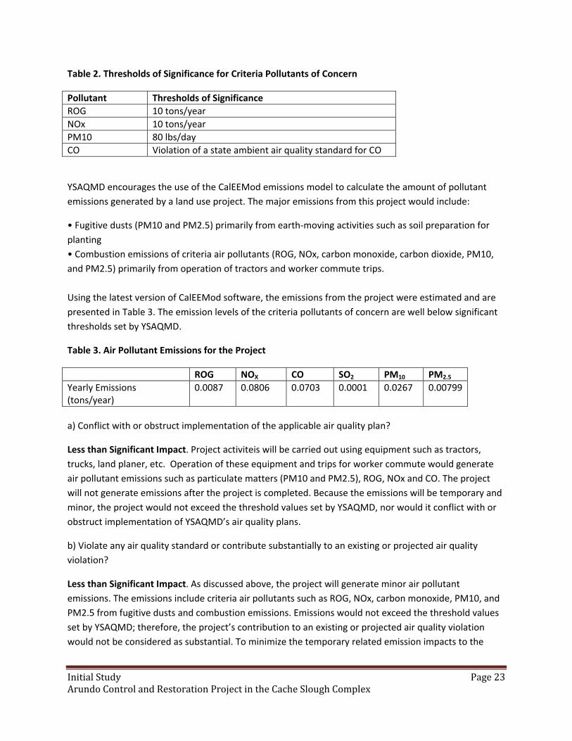
InitialStudy Page23ArundoControlandRestorationProjectintheCacheSloughComplex
Table 2. Thresholds of Significance for Criteria Pollutants of Concern
Pollutant Thresholds of Significance
ROG 10 tons/year
NOx 10 tons/year
PM10 80 lbs/day
CO Violation of a state ambient air quality standard for CO
YSAQMD encourages the use of the CalEEMod emissions model to calculate the amount of pollutant
emissions generated by a land use project. The major emissions from this project would include:
• Fugitive dusts (PM10 and PM2.5) primarily from earth‐moving activities such as soil preparation for
planting
• Combustion emissions of criteria air pollutants (ROG, NOx, carbon monoxide, carbon dioxide, PM10,
and PM2.5) primarily from operation of tractors and worker commute trips.
Using the latest version of CalEEMod software, the emissions from the project were estimated and are
presented in Table 3. The emission levels of the criteria pollutants of concern are well below significant
thresholds set by YSAQMD.
Table 3. Air Pollutant Emissions for the Project
ROG NOX CO SO2 PM10 PM2.5
Yearly Emissions (tons/year)
0.0087 0.0806 0.0703 0.0001 0.0267 0.00799
a) Conflict with or obstruct implementation of the applicable air quality plan?
Less than Significant Impact. Project activiteis will be carried out using equipment such as tractors,
trucks, land planer, etc. Operation of these equipment and trips for worker commute would generate
air pollutant emissions such as particulate matters (PM10 and PM2.5), ROG, NOx and CO. The project
will not generate emissions after the project is completed. Because the emissions will be temporary and
minor, the project would not exceed the threshold values set by YSAQMD, nor would it conflict with or
obstruct implementation of YSAQMD’s air quality plans.
b) Violate any air quality standard or contribute substantially to an existing or projected air quality
violation?
Less than Significant Impact. As discussed above, the project will generate minor air pollutant
emissions. The emissions include criteria air pollutants such as ROG, NOx, carbon monoxide, PM10, and
PM2.5 from fugitive dusts and combustion emissions. Emissions would not exceed the threshold values
set by YSAQMD; therefore, the project’s contribution to an existing or projected air quality violation
would not be considered as substantial. To minimize the temporary related emission impacts to the
InitialStudy Page24ArundoControlandRestorationProjectintheCacheSloughComplex
extent feasible, construction contractors would be required to implement best management practices
including:
• On‐road and off‐road vehicle tire pressures shall be maintained to manufacturer specifications. Tires
shall be checked and re‐inflated at regular intervals.
• Construction equipment engines shall be maintained to manufacturer’s specifications.
• The project will use properly tuned equipment that meets current emissions standards.
• BMPs will be implemented to minimize the potential for dust impacts from soil preparation activites
for restoration by pre‐irrigating soil to encourage the establishment of native grasses as soon as
possible.
The project will not build any permanent facilities with stationary or mobile sources of air pollutants.
There will be no operational air pollutant emissions from the project.
c) Result in a cumulatively considerable net increase of any criteria pollutant for which the project
region is non‐ attainment under an applicable federal or state ambient air quality standard (including
releasing emissions which exceed quantitative thresholds for ozone precursors)?
Less than Significant Impact. The pollutant emissions from the project are well below the corresponding
threshold values. Therefore, cumulative impacts caused by the project would be less than significant.
d) Expose sensitive receptors to substantial pollutant concentrations?
No Impact. No sensitive receptors are identified within close proximity to the project area. This project
does not propose uses or activities that would result in exposure of sensitive receptors to significant
pollutant concentrations. In addition, the project will not contribute to a cumulatively considerable
exposure of sensitive receptors to substantial pollutant concentrations because the proposed project
has emissions well below the screen in‐level criteria established by County guidelines for determining
significance.
e) Create objectionable odors affecting a substantial number of people?
No Impact. No potential sources of objectionable odors have been identified in association with the
project, and there will not be a substantial number of people in the project area. As such, no impact
from odors is anticipated.
Best Management Practices for Air Quality
Best management practices have been included in the Air Quality section above as well as the
Greenhouse Gas Emissions section (page 55).
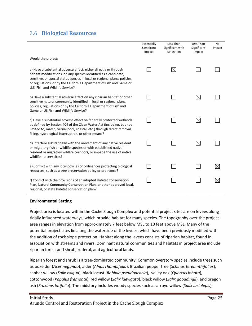
InitialStudy Page25ArundoControlandRestorationProjectintheCacheSloughComplex
BiologicalResources3.6
Potentially Significant Impact
Less Than Significant with
Mitigation
Less Than Significant Impact
No Impact
Would the project:
a) Have a substantial adverse effect, either directly or through habitat modifications, on any species identified as a candidate, sensitive, or special status species in local or regional plans, policies, or regulations, or by the California Department of Fish and Game or U.S. Fish and Wildlife Service?
b) Have a substantial adverse effect on any riparian habitat or other sensitive natural community identified in local or regional plans, policies, regulations or by the California Department of Fish and Game or US Fish and Wildlife Service?
c) Have a substantial adverse effect on federally protected wetlands as defined by Section 404 of the Clean Water Act (including, but not limited to, marsh, vernal pool, coastal, etc.) through direct removal, filling, hydrological interruption, or other means?
d) Interfere substantially with the movement of any native resident or migratory fish or wildlife species or with established native resident or migratory wildlife corridors, or impede the use of native wildlife nursery sites?
e) Conflict with any local policies or ordinances protecting biological resources, such as a tree preservation policy or ordinance?
f) Conflict with the provisions of an adopted Habitat Conservation Plan, Natural Community Conservation Plan, or other approved local, regional, or state habitat conservation plan?
Environmental Setting
Project area is located within the Cache Slough Complex and potential project sites are on levees along
tidally influenced waterways, which provide habitat for many species. The topography over the project
area ranges in elevation from approximately 7 feet below MSL to 10 feet above MSL. Many of the
potential project sites lie along the waterside of the levees, which have been previously modified with
the addition of rock slope protection. Habitat along the levees consists of riparian habitat, found in
association with streams and rivers. Dominant natural communities and habitats in project area include
riparian forest and shrub, ruderal, and agricultural lands.
Riparian forest and shrub is a tree‐dominated community. Common overstory species include trees such
as boxelder (Acer negundo), alder (Alnus rhombifolia), Brazilian pepper tree (Schinus terebinthifolius),
sanbar willow (Salix exigua), black locust (Robinia pseudoacacia), valley oak (Quercus lobata),
cottonwood (Populus fremontii), red willow (Salix laevigata), black willow (Salix gooddingii), and oregon
ash (Fraxinus latifolia). The midstory includes woody species such as arroyo willow (Salix lasiolepis),

InitialStudy Page26ArundoControlandRestorationProjectintheCacheSloughComplex
sandbar willow (Salix exigua), and buttonbush (Cephalanthus occidentalis). The understory includes
herbaceous species such as mugwort (Artemisia douglasiana), Bur‐marigold (Bidens sp.), rough horsetail
(Equisetum hyemale), western goldenrod (Euthamia occidentalis), soft rush (Juncus effusus), California
wild rose (Rosa californica), Himalayan blackberry (Rubus armeniacus), Suisun aster (Symphyotrichum
lentum), stinging nettle (Urtica dioica), and California wild grape (Vitis californica). Riparian areas
provide abundant habitat for aquatic and terrestrial invertebrates, amphibians, reptiles, birds, and small
mammals. Riparian vegetation overhanging and shading the river provides cover, water temperature
moderation, and invertebrate prey for salmonids.
Ruderal vegetation occurs along levees and other areas that have experienced disturbance. Weedy
species tend to dominate ruderal areas, including annual grasses, bur clover (Medicago polymorhpha),
bull thistle (Cirsium vulgare), knotweed (Polygonum spp.), dock (Rumex spp.), gumweed (Grindelia
camporum), cocklebur (Xanthium strumarium), and perennial pepperweed (Lepidium latifolium).
Although wildlife species benefits are less for ruderal areas than those of riparian habitats, ruderal areas
do provide breeding and foraging habitat for numerous species. Ruderal areas can support insects,
reptiles, small birds, and small mammals, as well as the raptors that prey on them. Species supported in
ruderal areas include burrowing owls (Athene cunicularia), red‐tailed hawk (Buteo jamaicensis),
American kestrel (Falco sparverius), western fence lizard (Sceloporus occidentalis), deer mouse
(Peromyscus spp.), Audubon cottontail (Sylvilagus audubonii), and black‐tailed jackrabbit (Lepus
californicus).
Agricultural crops are very common in the Delta region, covering a large portion of the project area and
bordering multiple potential project sites. Depending on the crop pattern and the proximity to native
habitats, agricultural lands can provide relatively high‐value habitat for wildlife, particularly as foraging
habitat. Several species of common rodents including deer mice and California vole (Microtus
californicus), are found in agricultural habitats and are preyed upon by a variety of raptor species.
Raptor species that use these areas for foraging include red‐tailed hawk, burrowing owl, Swainson’s
hawk (Buteo swainsoni), northern harrier (Circus cyaneus), and American kestrel. Agricultural fields also
provide foraging and resting habitat for migrating and wintering waterfowl and shorebirds.
Methods
Conservancy staff reviewed the following information to gather information regarding biological
resources in the project area:
California Natural Diversity Database (CNDDB) records for the Clarksburg, Courtland, Isleton,
Rio Vista, Birds Landing, Dozier, Liberty Island, Saxon, and Dixon 7.5‐minute USGS
quadrangles (CDFW 2015).
The U.S. Fish and Wildlife Service’s species list for the Clarksburg, Courtland, Isleton, Rio
Vista, Birds Landing, Dozier, Liberty Island, Saxon, and Dixon 7.5‐minute USGS quadrangles
(USFWS 2015).
The California Native Plant Society’s (CNPS) 2015 Inventory of Rare and Endangered Plants.
Aerial photographs of the potential project sites.
InitialStudy Page27ArundoControlandRestorationProjectintheCacheSloughComplex
Special‐status Species Definition
For the purposes of this analysis, “special‐status species” is a collective term that refers to plants and
animals that are legally protected under the federal Endangered Species Act (ESA), the California
Endangered Species Act (CESA), or other regulations, as well as species that are considered sufficiently
rare by the scientific community to quality for such listing. Special‐status plants and animals fall into the
following categories:
species listed or proposed for listing as threatened or endangered under ESA (50 CFR [Code
of Federal Regulations] 17.12 [listed plants], 50 CFR 17.11 [listed animals], and in various
notices in the Federal Register [FR][proposed species]);
species that are candidates for possible future listing as threatened or endangered under
ESA (USFWS 2015);
species listed or proposed for listing by the State of California as threatened or endanagered
under CESA (14 CCR 670.5);
species that meet the definitions of “rare” or “endangered” under CEQA (State CEQA
Guidelines, Section 15380);
plants listed as rare under the California Native Plant Protection Act (California Fish and
Game Code, Section 1900 et seq.);
plants considered by CNPS to be “rare, threatened, or endangered in California and
elsewhere (CNPS List 1B)” (CNPS 2015);
plants listed by CNPS as plants about which more information is needed to determine their
status and plants of limited distribution, which may be included as special‐status species on
the basis of local significants or recent biological information (CNPS 2015);
animal species of special concern to the CDFW (Williams 1986, CDFG 1994, and CDFG 2008);
and
animals fully protected in California (California Fish and Game Code, Sections 3511, 4700,
and 5050).
The information listed above was used to develop lists of sensitive species that could be present in the
region and to determine if sensitive natural communities could occur in potential project sites. Species
from the lists were evaluated if they are known to occur in the project vicinity or if suitable habitat for
the species is present within the project area. If potential habitat is present or the speciesis known to
occur near the project area, potential impacts due to the project were assessed and mitigation
measures proposed below. Sensitive plant and wildlife species that were identified as potentially
occurring in the project region are listed in Tables 4 and 5.
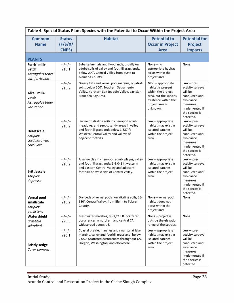
InitialStudy Page28ArundoControlandRestorationProjectintheCacheSloughComplex
Table 4. Special Status Plant Species with the Potential to Occur Within the Project Area
Common Name
Status (F/S/X/CNPS)
Habitat Potential to Occur in Project
Area
Potential for Project Impacts
PLANTS Ferris’ milk‐vetch Astragalus tener var. ferrisaiae
‐‐/‐‐/‐‐/1B.1
Subalkaline flats and floodlands, usually on adobe soils of valley and foothill grasslands, below 200'. Central Valley from Butte to Alameda County.
None—no appropriate habitat exists within the project area.
None.
Alkali milk‐vetch Astragalus tener var. tener
‐‐/‐‐/‐‐/1B.2
Grassy flats and vernal pool margins, on alkali soils, below 200'. Southern Sacramento Valley, northern San Joaquin Valley, east San Francisco Bay Area
Mod—appropriate habitat is present within the project area, but the species’ existence within the project area is unknown.
Low—pre‐activity surveys will be conducted and avoidance measures implemented if the species is detected.
Heartscale Atriplex cordulata var. cordulata
‐‐/‐‐/‐‐/1B.2
Saline or alkaline soils in chenopod scrub, meadows, and seeps, sandy areas in valley and foothill grassland; below 1,837 ft. Western Central Valley and valleys of adjacent foothills.
Low—appropriate habitat may exist in isolated patches within the project area.
Low— pre‐activity surveys will be conducted and avoidance measures implemented if the species is detected.
Brittlescale Atriplex depressa
‐‐/‐‐/‐‐/1B.2
Alkaline clay in chenopod scrub, playas, valley and foothill grasslands; 3‐1,049 ft western and eastern Central Valley and adjacent foothills on west side of Central Valley.
Low—appropriate habitat may exist in isolated patches within the project area.
Low— pre‐activity surveys will be conducted and avoidance measures implemented if the species is detected.
Vernal pool smallscale Atriplex persistens
‐‐/‐‐/‐‐/1B.2
Dry beds of vernal pools, on alkaline soils, 33‐380'. Central Valley, from Glenn to Tulare County.
None—vernal pool habitat does not occur within the project area.
None
Watershield Brasenia schreberi
‐‐/‐‐/‐‐/2B.3
Freshwater marshes; 98‐7,218 ft. Scattered occurrences in northern and central CA; widespread across US.
None—project is outside the elevation range of the species.
None
Bristly sedge Carex comosa
‐‐/‐‐/‐‐/2B.1
Coastal prairie, marshes and swamps at lake margins, valley and foothill grassland; below 2,050. Scattered occurrences throughout CA, Oregon, Washington, and elsewhere.
Low—appropriate habitat may exist in isolated patches within the project area.
Low— pre‐activity surveys will be conducted and avoidance measures implemented if the species is detected.

InitialStudy Page29ArundoControlandRestorationProjectintheCacheSloughComplex
Table 4. Special Status Plant Species with the Potential to Occur Within the Project Area
Common Name
Status (F/S/X/CNPS)
Habitat Potential to Occur in Project
Area
Potential for Project Impacts
Pappose tarplant Centromadia parryi ssp. parryi
‐‐/‐‐/‐‐/1B.2
Coastal prairie, meadows and seeps, coastal salt marshes and swamps, alkaline soils in vernally mesic valley and foothill grassland; 6‐1,378 ft. North and Central Coast Ranges, the southern Sacramento Valley; occurrences in Butte, Colusa, Glenn, Lake, Napa, San Mateo, and Solano counties.
None—no appropriate habitat exists within the project area.
None
Parry’s rough tarplant Centromadia parryi ssp. Rudis
‐‐/‐‐/‐‐/4.2
Alkaline, vernally mesic, seeps, sometimes roadsides, valley and foothill grassland, vernal pools.
None—no appropriate habitat exists within the project area.
None
Bolander’s water‐hemlock Cicuta maculate var. bolanderi
‐‐/‐‐/‐‐/2B.1
Found in marshes and swamps, and coastal, fresh or brackish water habitats.
Mod—appropriate habitat is present within the project area, but the species’ existence within the project area is unknown.
Low—pre‐activity surveys will be conducted and avoidance measures implemented if the species is detected.
Dwarf downingia Downingia pusilla
‐‐/‐‐/‐‐/2B.2
Wet areas in valley and foothill grassland, vernal pools; 3‐1,460 ft. Inner North Coast Ranges, southern Sacramento Valley, northern and central San Joaquin Valley.
Mod—appropriate habitat is present within the project area, but the species’ existence within the project area is unknown.
Low—pre‐activity surveys will be conducted and avoidance measures implemented if the species is detected.
San joaquin spearscale Etriplex joaquinana
‐‐/‐‐/‐‐/1B.2
Alkaline. Chenopod scrub, alkali meadow and seeps, playas, alkali valley and foothill grassland, saltbush scrub. West edge of Central Valley from Glenn County to Tulare County
Low—appropriate habitat may exist in isolated patches within the project area.
Low—pre‐activity surveys will be conducted and avoidance measures implemented if the species is detected.
Fragrant fritillary Fritillaria liliacea
‐‐/‐‐/‐‐/1B.2
Adobe soils of interior foothills, coastal prairie, coastal scrub, valley and foothill grassland, often on serpentinite; 10‐1,345 ft. Coast Ranges from Marin County to San Benito County.
None—no appropriate habitat exists within the project area.
None
Adobe‐lily Fritillaria pluriflora
‐‐/‐‐/‐‐/1B.2
Chaparral, cismontane woodland, valley and foothill grassland, often on adobe soils; 197‐2,313 ft. Northern Sierra Nevada foothills; Inner North Coast Ranges, edges of Sacramento Valley.
None—no appropriate habitat exists within the project area.
None
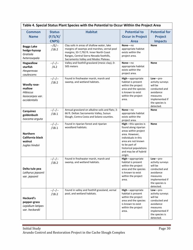
InitialStudy Page30ArundoControlandRestorationProjectintheCacheSloughComplex
Table 4. Special Status Plant Species with the Potential to Occur Within the Project Area
Common Name
Status (F/S/X/CNPS)
Habitat Potential to Occur in Project
Area
Potential for Project Impacts
Boggs Lake hedge‐hyssop Gratiola heterosepala
‐‐/E/‐‐/1B.2
Clay soils in areas of shallow water, lake margins of swamps and marshes, vernal pool margins; 33‐7,792 ft. Inner North Coast Ranges, Central Sierra Nevada foothills, Sacramento Valley and Modoc Plateau.
None—no appropriate habitat exists within the project area.
None
Hogwallow starfish Hesperevax caulescens
‐‐/‐‐/‐‐/4.2
Valley and foothill grassland (mesic clay), 0‐505 meters
None—no appropriate habitat exists within the project area.
None
Woolly rose‐mallow Hibiscus lasiocarpos var. occidentalis
‐‐/‐‐/‐‐/1B.2
Found in freshwater marsh, marsh and swamp, and wetland habitats.
High—appropriate habitat is present within the project area and the species is known to exist within the project area.
Low—pre‐activity surveys will be conducted and avoidance measures implemented if the species is detected.
Carquinez goldenbush Isocoma arguta
‐‐/‐‐/‐‐/1B.1
Annual grassland on alkaline soils and flats; 3‐66 ft. Deltaic Sacramento Valley, Suisun Slough, Contra Costa and Solano counties.
None—no appropriate habitat exists within the project area.
None
Northern California black walnut Juglas hindsii
‐‐/‐‐/‐‐/1B.1
Found in riparian forest and riparian woodland habitats.
High—this species is found along riparian areas within project area. However, individuals in this area are not known to be part of historical populations and may be of hybrid origin.
None
Delta tule pea Lathyrus jepsonii var. jepsonii
‐‐/‐‐/‐‐/1B.2
Found in freshwater marsh, marsh and swamp, and wetland habitats.
High—appropriate habitat is present within the project area and the species is known to exist within the project area.
Low—pre‐activity surveys will be conducted and avoidance measures implemented if the species is detected.
Heckard’s pepper‐grass Lepidium latipes var. heckardii
‐‐/‐‐/‐‐/1B.2
Found in valley and foothill grassland, vernal pool, and wetland habitats.
High—appropriate habitat is present within the project area and the species is known to exist within the project area.
Low—pre‐activity surveys will be conducted and avoidance measures implemented if the species is detected.
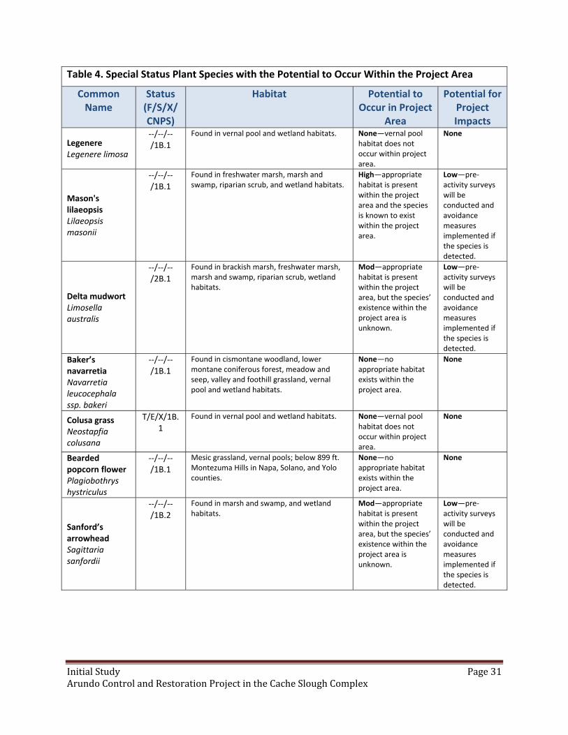
InitialStudy Page31ArundoControlandRestorationProjectintheCacheSloughComplex
Table 4. Special Status Plant Species with the Potential to Occur Within the Project Area
Common Name
Status (F/S/X/CNPS)
Habitat Potential to Occur in Project
Area
Potential for Project Impacts
Legenere Legenere limosa
‐‐/‐‐/‐‐/1B.1
Found in vernal pool and wetland habitats. None—vernal pool habitat does not occur within project area.
None
Mason's lilaeopsis Lilaeopsis masonii
‐‐/‐‐/‐‐/1B.1
Found in freshwater marsh, marsh and swamp, riparian scrub, and wetland habitats.
High—appropriate habitat is present within the project area and the species is known to exist within the project area.
Low—pre‐activity surveys will be conducted and avoidance measures implemented if the species is detected.
Delta mudwort Limosella australis
‐‐/‐‐/‐‐/2B.1
Found in brackish marsh, freshwater marsh, marsh and swamp, riparian scrub, wetland habitats.
Mod—appropriate habitat is present within the project area, but the species’ existence within the project area is unknown.
Low—pre‐activity surveys will be conducted and avoidance measures implemented if the species is detected.
Baker’s navarretia Navarretia leucocephala ssp. bakeri
‐‐/‐‐/‐‐/1B.1
Found in cismontane woodland, lower montane coniferous forest, meadow and seep, valley and foothill grassland, vernal pool and wetland habitats.
None—no appropriate habitat exists within the project area.
None
Colusa grass Neostapfia colusana
T/E/X/1B.1
Found in vernal pool and wetland habitats. None—vernal pool habitat does not occur within project area.
None
Bearded popcorn flower Plagiobothrys hystriculus
‐‐/‐‐/‐‐/1B.1
Mesic grassland, vernal pools; below 899 ft. Montezuma Hills in Napa, Solano, and Yolo counties.
None—no appropriate habitat exists within the project area.
None
Sanford’s arrowhead Sagittaria sanfordii
‐‐/‐‐/‐‐/1B.2
Found in marsh and swamp, and wetland habitats.
Mod—appropriate habitat is present within the project area, but the species’ existence within the project area is unknown.
Low—pre‐activity surveys will be conducted and avoidance measures implemented if the species is detected.

InitialStudy Page32ArundoControlandRestorationProjectintheCacheSloughComplex
Table 4. Special Status Plant Species with the Potential to Occur Within the Project Area
Common Name
Status (F/S/X/CNPS)
Habitat Potential to Occur in Project
Area
Potential for Project Impacts
Side‐flowering skullcap Scutellaria lateriflora
‐‐/‐‐/‐‐/2B.2
Found in marsh and swamp, meadow and seep, and wetland habitats.
Mod—appropriate habitat is present within the project area, but the species’ existence within the project area is unknown.
Low—pre‐activity surveys will be conducted and avoidance measures implemented if the species is detected.
Keck's checkerbloom (=checkerbloom) Sidalcea keckii
E/‐‐/‐‐/1B.1
Serpentine clay soils in cismontane woodland, valley and foothill grassland. Known historically from occurrences in Fresno, Merced, and Tulare counties; similar plants from Inner North Coast Ranges in Colusa, Napa, Solano, and Yolo counties treated as this species till further studies done.
None—no appropriate habitat exists within the project area.
None
Suisun Marsh aster Symphyotrichum lentum
‐‐/‐‐/‐‐/1B.2
Found in brackish marsh, freshwater marsh, marsh and swamp, and wetland habitats.
High—appropriate habitat is present within the project area and the species is known to exist within the project area.
Low—pre‐activity surveys will be conducted and avoidance measures implemented if the species is detected.
Saline clover Trifolium hydrophilum
‐‐/‐‐/‐‐/1B.2
Salt marsh, mesic alkaline areas in valley and foothill grasslands, vernal pools, marshes and swamps; below 984 ft. Sacramento Valley, central Western CA.
None—no appropriate habitat exists within the project area.
None
Crampton's tuctoria or Solano grass Tuctoria mucronata
E/E/X/1B.1
Found in valley and foothill mesic grassland, vernal pool and wetland habitats; 16‐33 ft. Southwestern Sacramento Valley in Solano and Yolo counties.
None—no appropriate habitat exists within the project area.
None
Status Federal (F) : E = listed as endangered under the Federal Endangered Species Act T = listed as threatened under the Federal Endangered Species Act
State (S) : E = listed as endangered under the State Endangered Species Act T = listed as threatened under the State Endangered Species Act
Critical Habitat Designation (X)
CA Native Plant Society Listing (CNPS)

InitialStudy Page33ArundoControlandRestorationProjectintheCacheSloughComplex
Table 5. Special Status Fish and Wildlife Species with the Potential to Occur Within the Project Area
Common Name
Status (F/S/X)
Habitat Potential to Occur in Project
Area
Potential for Project Impacts
INVERTEBRATES Blennosperma vernal pool andrenid bee Andrena blennospermatis
‐‐/‐‐/‐‐ Upland areas near vernal pools None—vernal pool habitat does not occur within the project area
None
Antioch Dunes anthicid beetle Anthicus antiochensis
‐‐/‐‐/‐‐ Interior sand dunes and sand bars None—no appropriate habitat exists within the project area
None
Sacramento anthicid beetle Anthicus sacramento
‐‐/‐‐/‐‐ Interior sand dunes and sand bars with some vegetative cover. Also can be found in dredge spoil heaps. Found in locations along the Sacramento and San Joaquin Rivers from Shasta to San Joaquin Counties, and at one site along the Feather River
None—no appropriate habitat exists within the project area.
None
Conservancy Fairy Shrimp Branchinecta conservatio
E/‐‐/‐‐ Large, cool‐water vernal pools with moderately turbid water
None—vernal pool habitat does not occur within the project area
None
Midvalley fairy shrimp Banchinecta mesovallensis
‐‐/‐‐/‐‐ Found in small short‐lived vernal pools and grass‐bottomed swales ranging from 4‐663 square feet in area and averaging less than 4 inches in depth
None—vernal pool habitat does not occur within the project area
None
Vernal Pool Fairy Shrimp Branchinecta lynchi
T/‐‐/X Vernal pools; also sandstone rock outcrop pools
None—vernal pool habitat does not occur within the project area
None
Valley Elderberry Longhorn Beetle Desmocerus californicus dimorphus
T/‐‐/X Riparian and oak savanna habitats with blue elderberry shrubs; elderberries are the host plant
Mod—appropriate habitat is present within the project area, but the species’ existence within the project area is unknown
Low—pre‐activity surveys will be conducted and avoidance measures implemented to avoid all elderberry shrubs in and around project area
Delta Green Ground Beetle Elaphrus viridis
T/‐‐/X Species is only known to occur in south‐central Solano County, near Jepson Prairie Preserve. Habitat requirements not well developed, believed that the species prefers more open habitats in the grassland‐playa pool matrix
None—no appropriate habitat exists within the project area
None

InitialStudy Page34ArundoControlandRestorationProjectintheCacheSloughComplex
Table 5. Special Status Fish and Wildlife Species with the Potential to Occur Within the Project Area
Common Name
Status (F/S/X)
Habitat Potential to Occur in Project
Area
Potential for Project Impacts
Ricksecker’s water scavenger beetle Hydrochara rickseckeri
‐‐/‐‐/‐‐ Aquatic, known to occur in vernal pools. Recorded in central coastal CA and southern Sacramento Valley, known to occur in Solano County near Jepson Prairie
None—vernal pool habitat does not occur within the project area
None
Vernal Pool Tadpole Shrimp Lepidurus packardi
E/‐‐/X Occupies a variety of vernal pool habitats in Central Valley and San Francisco Bay Area
None—vernal pool habitat does not occur within the project area
None
California linderiella Linderiella occidentalis
‐‐/‐‐/‐‐ Vernal pools, swales, and other ephemeral wetlands. Central Valley and central coastal CA
None—vernal pool habitat does not occur within the project area
None
FISH Green Sturgeon‐ Southern DPS Acipenser medirostris
T/‐‐/‐‐ Large, main stem rivers with cool water and cobble, clean sand, or bedrock for spawning
High—project area is within species’ known range; appropriate habitat is present
Low—in‐stream work will not be conducted and measures (BMPs) will be taken to avoid runoff impacts to streams
Delta Smelt Hypomesus transpacificus
T/E/X Tidal areas from fresh water up to 18 ppt, but primarily near and upstream of the brackish zone where bottom salinity is approximately 2 ppt. Spawning occurs in tidal areas, most commonly upstream of salinity at 2 ppt. High turbidity levels (e.g. >10 ntu) and moderate temperatures (<25°C) are required for all life stages
High—project area is within species’ known range and critical habitat; appropriate habitat is present
Low—in‐stream work will not be conducted and measures (BMPs) will be taken to avoid runoff impacts to streams
River Lamprey Lampetra ayresii
SC/SSC/‐‐ Anadromous parasitic species found in coastal streams and upper reaches of San Francisco Estuary and tributaries; spawn in streams in spring; adults may migrate briefly to ocean before returning in fall
High—project area is within species’ known range; appropriate habitat is present
Low—in‐stream work will not be conducted and measures (BMPs) will be taken to avoid runoff impacts to streams
Hardhead Mylopharodon conocephalus
‐‐/SSC/‐‐ Low‐ to mid‐elevations in relatively undisturbed habitats of larger streams, with high water quality (clear, cool)
High— project area is within species’ known range; appropriate habitat is present
Low—in‐stream work will not be conducted and measures (BMPs) will be taken to avoid runoff impacts to streams

InitialStudy Page35ArundoControlandRestorationProjectintheCacheSloughComplex
Table 5. Special Status Fish and Wildlife Species with the Potential to Occur Within the Project Area
Common Name
Status (F/S/X)
Habitat Potential to Occur in Project
Area
Potential for Project Impacts
Steelhead ‐ Central Valley DPS Oncorhynchus mykiss irideus
T/‐‐/X Central Valley main river systems. Spawn in small, freshwater tributaries. Juveniles remain in freshwater for several years before returning to the ocean. Main rearing habitat is in stream/river systems
High—project area is within species’ known range; appropriate habitat is present
Low—in‐stream work will not be conducted and measures (BMPs) will be taken to avoid runoff impacts to streams
Central Valley Spring‐run Chinook Salmon Oncorhynchus tshawytscha
T/T/X Low‐ to mid‐elevation rivers and streams with cold water, clean gravel of appropriate size for spawning, and suitable rearing habitat; typically rear in freshwater for one or more years before migrating to the ocean
High—project area is within species’ known range and critical habitat; appropriate habitat is present
Low—in‐stream work will not be conducted and measures (BMPs) will be taken to avoid runoff impacts to streams
Sacramento River Winter‐run Chinook Salmon Oncorhynchus tshawytscha
E/E/X Low‐ to mid‐elevation rivers and streams with cold water, clean gravel of appropriate size for spawning, and suitable rearing habitat; typically rear in freshwater for one or more years before migrating to the ocean
High—project area is within species’ known range and critical habitat; appropriate habitat is present
Low—in‐stream work will not be conducted and measures (BMPs) will be taken to avoid runoff impacts to streams
Klamath‐Trinity Rivers Spring‐run Chinook Salmon Oncorhynchus tshawytscha
‐‐/SSC/‐‐ Low‐ to mid‐elevation rivers and streams with cold water, clean gravel of appropriate size for spawning, and suitable rearing habitat; typically rear in freshwater for one or more years before migrating to the ocean
Mod—project area is within potential movement route, but species’ existence within the project area is unknown; appropriate habitat is present
Low—in‐stream work will not be conducted and measures (BMPs) will be taken to avoid runoff impacts to streams
Longfin Smelt Spirinchus thaleichthys
C/T/‐‐ Euryhaline (capable of tolerating a wide range of salinities), pelagic and anadromous species found in scattered bays and estuaries from CA to Alaska
High—project area is within species’ known range; appropriate habitat is present
Low—in‐stream work will not be conducted and measures (BMPs) will be taken to avoid runoff impacts to streams
AMPHIBIANS California Tiger Salamander Ambystoma californiense
T/T/X Natural vernal pools or seasonal ponds and in burrows in adjacent uplands in parts of the Central Valley grasslands and low foothill regions
Low—perennial streams rarely used for breeding; upland land uses (crop, levee) inappropriate for aestivation
Low—pre‐activity surveys will be conducted and avoidance measures implemented if the species is detected.

InitialStudy Page36ArundoControlandRestorationProjectintheCacheSloughComplex
Table 5. Special Status Fish and Wildlife Species with the Potential to Occur Within the Project Area
Common Name
Status (F/S/X)
Habitat Potential to Occur in Project
Area
Potential for Project Impacts
California Red‐legged Frog Rana draytonii
T/SSC/X Permanent and semi‐permanent aquatic habitats such as creeks and cold‐water ponds, with emergent and submergent vegetation and in cracks and burrows in adjacent uplands. Species currently known confined to isolated localities in the Sierra Nevada, northern Coast Range, and Northern Transverse Range. Common in San Francisco Bay area and along the Central coast.
None—Project area is outside current known range of species
None
REPTILES Western Pond Turtle Emys marmorata
‐‐/SSC/‐‐ Variety of permanent and intermittent aquatic habitats throughout the state, including rivers, streams, lakes, ponds, marshes, vernal pools, and human‐constructed environments such as ponds associated with waste‐water, stock, and logging operations. Nest in grassy uplands and overwinter under mud, dirt, or leaf litter
High—Western pond turtles are relatively common throughout the rivers, sloughs, ponds, and irrigation ditches in the project area
Low— in‐stream work will not be conducted and measures (BMPs) will be taken to avoid runoff impacts to streams. There is a small chance of impacting nests; however, pre‐activity surveys will be conducted and avoidance measures implemented if the species is detected.
Giant Garter Snake Thamnophis gigas
T/T/‐‐ Sloughs, canals, low‐gradient streams and marsh habitats; irrigation ditches and rice fields; grassy banks and emergent vegetation for basking; high ground crack or burrows protected from flooding in the Central Valley
Mod—appropriate habitat is present within the project area, but the species’ existence within the project area is unknown.
Low— in‐stream work will not be conducted and measures (BMPs) will be taken to avoid runoff impacts to streams. Pre‐activity surveys will be conducted and avoidance measures implemented if the species is detected.

InitialStudy Page37ArundoControlandRestorationProjectintheCacheSloughComplex
Table 5. Special Status Fish and Wildlife Species with the Potential to Occur Within the Project Area
Common Name
Status (F/S/X)
Habitat Potential to Occur in Project
Area
Potential for Project Impacts
MAMMALS Western Red Bat Lasiurus blossevillii
‐‐/SSC/‐‐ Roosts primarily in tree foliage, occasionally shrubs; roosts in small family groups rather than large colonies as other bats; prefers habitat edges and mosaics with trees that are protected from above and open below with open areas for foraging, including grasslands, shrublands, and open woodlands
High—Year‐round range spans the Central Valley, Sierra Nevada foothills, coast Ranges, and coast except Humboldt and Del Norte counties. Documented foraging in most habitat types in the Delta. Roosting documented in the Delta at Brannan Island State Recreation Area.
Low—Trees will not be removed. If trimming is required, pre‐activity surveys will be conducted and avoidance measures implemented if the species is detected.
Hoary bat Lasiurus cinereus
‐‐/‐‐/‐‐ Roosts in dense foliage of medium to large trees; preferred sites are hidden from above, with few branches below. Solitary species
High—Common, widespread bat with the potential to occur anywhere in CA
Low—Trees will not be removed. If trimming is required, pre‐activity surveys will be conducted and avoidance measures implemented if the species is detected.
Salt‐Marsh Harvest Mouse Reithrodontomys raviventris
E/E,FP/‐‐ Saline and brackish marshes with thick cover of halophytic plants with layered structure
None—Project area is outside current known range of species
None
American Badger Taxidea taxus
‐‐/SSC/‐‐ Drier open shrub, forest, and herbaceous habitats with friable soils. Year‐round range spans all of CA except the Humboldt and Del Norte coasts
None—no appropriate habitat exists within the project area
None
BIRDS Cooper's Hawk Accipiter cooperii
‐‐/WL/‐‐ Nests in riparian woodlands, gray pine‐oak woodlands, mixed conifer forests
High—appropriate nesting and foraging habitat is present within the project area and the species is known to exist near the project area
Low—Trees will not be removed. If trimming is required, efforts will be made to conduct trimming outside of nesting season. Otherwise, pre‐activity surveys will be

InitialStudy Page38ArundoControlandRestorationProjectintheCacheSloughComplex
Table 5. Special Status Fish and Wildlife Species with the Potential to Occur Within the Project Area
Common Name
Status (F/S/X)
Habitat Potential to Occur in Project
Area
Potential for Project Impacts
conducted and avoidance measures implemented if nests are detected.
Tricolored Blackbird Agelaius tricolor
BCC/E/‐‐ Nests colonially in large, dense stands of freshwater marsh, riparian scrub, and other shrubs and herbs; forages in grasslands and agricultural fields
High—appropriate nesting and foraging habitat is present within the project area and the species is known to exist near the project area
Low—pre‐activity surveys will be conducted and avoidance measures implemented if a nesting colony is detected.
Grasshopper Sparrow Ammodramus savannarum
‐‐/SSC/‐‐ Nests and forages in short to mid‐height, moderately open grasslands; favors a mix of native grasses, forbs, and scattered shrubs
High—appropriate nesting and foraging habitat is present within the project area and the species is known to exist near the project area
Low—pre‐activity surveys will be conducted and avoidance measures implemented if a nest is detected.
Golden Eagle Aquila chrysaetos
‐‐/FP,WL /‐‐
Nests on cliffs or in the largest trees of forested stands that often afford an unobstructed view of the surrounding habitat, usually, sticks and soft material added to existing nests, or new nests that are constructed to create strong, flat or bowl shaped platforms
Mod—Appropriate foraging habitat exists within the project area. This species is known to forage near the project area but is not likely to nest here.
Low—Trees will not be removed. If trimming is required, efforts will be made to conduct trimming outside of nesting season. Otherwise, pre‐activity surveys will be conducted and avoidance measures implemented if nests are detected
Burrowing Owl Athene cunicularia
BCC/SSC/‐‐ Level, open, dry, heavily grazed or low stature grassland or desert vegetation with available rodent burrows
High—appropriate nesting and foraging habitat is present within the project area and the species is known to exist near the project area.
Low—pre‐activity surveys will be conducted and avoidance measures implemented if an active burrow is detected.

InitialStudy Page39ArundoControlandRestorationProjectintheCacheSloughComplex
Table 5. Special Status Fish and Wildlife Species with the Potential to Occur Within the Project Area
Common Name
Status (F/S/X)
Habitat Potential to Occur in Project
Area
Potential for Project Impacts
Ferruginous Hawk Buteo regalis
‐‐/WL /‐‐ Winters in open grasslands, scrub, low foothills surrounding valleys
Mod—appropriate foraging habitat may exist in isolated patches within the project area. Species does not nest near project area
Low—Species does not nest in project area and impacts to foraging habitat are unlikely
Swainson's Hawk Buteo swainsoni
BCC/T (nesting)/‐
‐
Nests peripheral to riparian systems or lone trees in agricultural fields or along roadsides when adjacent to suitable foraging habitat such as grasslands or agricultural fields, particularly alfalfa
High—appropriate nesting and foraging habitat is present within the project area and the species is known to exist near the project area.
Low—Trees will not be removed. If trimming is required, efforts will be made to conduct trimming outside of nesting season. Otherwise, pre‐activity surveys will be conducted and avoidance measures implemented if nests are detected
Mountain Plover Charadrius montanus
PT, BCC/SSC
(wintering)/‐‐
Winters in sparsely vegetated or disked fields and grazed grasslands nearly devoid of vegetation
None—appropriate habitat does not exist within the project area.
None
Northern Harrier Circus cyaneus
‐‐/SSC (nesting)/‐
‐
Nests and roosts on the ground among primarily in open wetlands, but also in a wide variety of habitats, wet pastures and grasslands
High—appropriate nesting and foraging habitat is present within the project area and the species is known to exist near the project area.
Low—pre‐activity surveys will be conducted and avoidance measures implemented if a nest is detected.
Western Yellow‐billed Cuckoo Coccyzus americanus occidentalis
T, BCC/E/‐‐ Nests in valley, foothill, and desert riparian forest with dense deciduous trees and shrubs, especially willows; other associated vegetation includes cottonwood trees, blackberry, nettle, and wild grape
Low—species has not been documented nesting in the region in recent history. Individualts may use nearby riparian habitats during migration, but most habitat habitat within the project area is too fragmented for nesting by this
None

InitialStudy Page40ArundoControlandRestorationProjectintheCacheSloughComplex
Table 5. Special Status Fish and Wildlife Species with the Potential to Occur Within the Project Area
Common Name
Status (F/S/X)
Habitat Potential to Occur in Project
Area
Potential for Project Impacts
species.
White‐tailed Kite Elanus leucurus
‐‐/FP (nesting)/‐
‐
Forages in open areas such as grasslands, oak savannahs, and woodlands, scrublands, and marshes; nests in trees and tall shrubs adjacent to foraging habitat
High—appropriate nesting and foraging habitat is present within the project area and the species is known to exist near the project area.
Low—Trees will not be removed. If trimming is required, efforts will be made to conduct trimming outside of nesting season. Otherwise, pre‐activity surveys will be conducted and avoidance measures implemented if nests are detected.
California Horned Lark Eremophila alpestris actia
‐‐/WL/‐‐ Occupies a variety of open habitats, usually where large trees and shrubs are absent
Low—Species may forage and overwinter near project area, but habitat is not appropriate for nesting. Species is not known to exist in the project area.
None
Saltmarsh Common Yellowthroat Geothlypis trichas sinuosa
‐‐/SSC/‐‐ Freshwater marshes in summer and salt or brackish marshes in fall and winter, requires tall grasses, tules, and willow thickets for nesting and cover
None—Project area is outside current known range of species
None
Lesser Sandhill Crane Grus canadensis canadensis
‐‐/SSC/‐‐ Winter habitats include annual and perrenial grasslands, moist croplands with rice or corn stubble, and open, emergent wetlands
Low—This species may forage near the project area, but all known roosting locations are well east of the project area. Species does not nest in this region.
None
Greater Sandhill Crane Grus canadensis tabida
‐‐/T,FP/‐‐ Winter habitats include annual and perrenial grasslands, moist croplands with rice or corn stubble, and open, emergent wetlands
Low—This species may forage near the project area, but all known roosting locations are well
None

InitialStudy Page41ArundoControlandRestorationProjectintheCacheSloughComplex
Table 5. Special Status Fish and Wildlife Species with the Potential to Occur Within the Project Area
Common Name
Status (F/S/X)
Habitat Potential to Occur in Project
Area
Potential for Project Impacts
east of the project area. Species does not nest in this region.
Yellow‐breasted Chat Icteria virens
‐‐/SSC/‐‐ Uses several habitats, especially riparian thickets and brush
Low‐‐ appropriate habitat may be present in isolated patches within the project area, but species is not known to exist in the project area.
None
Loggerhead Shrike Lanius ludovicianus
‐‐/SSC/‐‐ Prefers open habitats with scattered shrubs, trees, fences, posts, utility lines, or other perches
Mod—appropriate habitat exists within the project area and species is known to forage here. Species is not known to nest within project area.
Low‐‐Trees will not be removed. If trimming is required, efforts will be made to conduct trimming outside of nesting season. Otherwise, pre‐activity surveys will be conducted and avoidance measures implemented if nests are detected.
Song Sparrow (Modesto‐in population) Melospiza melodia
‐‐/SSC/‐‐ Nests in emergent marsh, riparian scrub, riparian thickets, and riparian forest with blackberry understory, and along vegetated canals and levees
High—appropriate nesting and foraging habitat is present within the project area and the species is known to nest and forage near the project area.
Low—pre‐activity surveys will be conducted and avoidance measures implemented if nests are detected.
Osprey Pandion haliaetus
‐‐/WL/‐‐ Associated strictly with large, fish‐bearing waters, primarily in mixed conifer habitats. Often nest on artificial platforms.
High—appropriate nesting and foraging habitat is present within the project area and the species is known to exist near the project area.
Low—Infrastructure that may support nesting platforms will not be disturbed. Trees will not be removed. If trimming is required, efforts will be made to
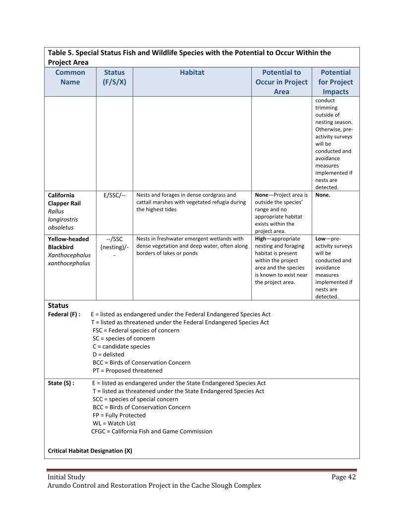
InitialStudy Page42ArundoControlandRestorationProjectintheCacheSloughComplex
Table 5. Special Status Fish and Wildlife Species with the Potential to Occur Within the Project Area
Common Name
Status (F/S/X)
Habitat Potential to Occur in Project
Area
Potential for Project Impacts
conduct trimming outside of nesting season. Otherwise, pre‐activity surveys will be conducted and avoidance measures implemented if nests are detected.
California Clapper Rail Rallus longirostris obsoletus
E/SSC/‐‐ Nests and forages in dense cordgrass and cattail marshes with vegetated refugia during the highest tides
None—Project area is outside the species’ range and no appropriate habitat exists within the project area.
None.
Yellow‐headed Blackbird Xanthocephalus xanthocephalus
‐‐/SSC (nesting)/‐
‐
Nests in freshwater emergent wetlands with dense vegetation and deep water, often along borders of lakes or ponds
High—appropriate nesting and foraging habitat is present within the project area and the species is known to exist near the project area.
Low—pre‐activity surveys will be conducted and avoidance measures implemented if nests are detected.
Status Federal (F) : E = listed as endangered under the Federal Endangered Species Act T = listed as threatened under the Federal Endangered Species Act FSC = Federal species of concern SC = species of concern C = candidate species D = delisted BCC = Birds of Conservation Concern PT = Proposed threatened
State (S) : E = listed as endangered under the State Endangered Species Act T = listed as threatened under the State Endangered Species Act SCC = species of special concern BCC = Birds of Conservation Concern FP = Fully Protected WL = Watch List CFGC = California Fish and Game Commission
Critical Habitat Designation (X)

InitialStudy Page43ArundoControlandRestorationProjectintheCacheSloughComplex
Plants
Based upon the results of the database searches described in the methods above, 33 special‐status plant
species were considered in this analysis. Of these 33 total species, 12 have a moderate or high potential
to occur in the project area (Table 4). Several species are not likely to occur because habitats are not
present within the project area, such as mesic areas (vernal pools) and/or in alkaline soils, and valley and
foothill grassland habitats. The habitat at many of the project sites is of moderate to low quality for
special‐status plants because of disturbance by agricultural activities and other human activities. In
some cases, a road atop the levee crown and associated mowing activities increase the spread of non‐
native plants. The levees are human‐made structures which experience regular disturbance due to
maintenance and other construction activities and in some areas are heavily dominated by non‐native
species. However, some potential project sites contain intact riparian forest and shrub habitat or
isolated fragments of natural soil and hydrological conditions with an increased likelihood of special‐
status plant occurrence.
Fish
Based on existing information, 9 special‐status fish species were considered for this project. Of the 9
total species, all 9 have a moderate or high potential to occur in the project area (Table 5). The project
area is within the known range of 8 species and project sites have the potential to border streams
and/or sloughs containing habitat for, and individuals of, all 9 species.
Wildlife
Based on a review of existing information, 40 special‐status wildlife species were considered for this
analysis. Of these 40 total species, 18 have a moderate or high potential to occur in the project area
(Table 5).
Valley elderberry longhorn beetle has a moderate potential to occur in the project area on potential
project sites that contain elderberry shrubs. While it is unknown whether these shrubs contain the
beetle, all sites containing elderberry shrubs are considered to have the potential for valley elderberry
longhorn beetle occurrence.
Western pond turtle is known to occur in the project area and is relatively common in local streams and
sloughs. Giant garter snake has the potential to occur throughout the project area where appropriate
habitat exists, but it is not known to occur here.
Western red bat and hoary bat each have a high potential to occur within the project area. These
widespread bat species have the potential to forage across all potential project sites and to roost at
potential project sites containing appropriate roost trees.
Thirteen special‐status bird species have a moderate or high potential to occur in the project area. A
number of species, including Cooper’s hawk, Swainson’s hawk, northern harrier, burrowing owl, white‐
tailed kite, osprey, tricolored blackbird, grasshopper sparrow, song sparrow, and yellow‐headed

InitialStudy Page44ArundoControlandRestorationProjectintheCacheSloughComplex
blackbird are known to exist within the project area. These species are likely to be found foraging in
appropriate habitat across all project sites and may nest within potential project sites if appropriate
nesting habitat exists. Appropriate nesting habitat may be comprised of riparian trees, artificial
platforms, shrubs, thistle, or burrows, depending up on the species. Additional avian species may be
found foraging within project sites but are very unlikely to nest anywhere in the project area. These
species include golden eagle, ferruginous hawk, and loggerhead shrike.
Discussion
a) Have a substantial adverse effect, either directly or through habitat modifications, on any species
indentified as a candidate, sensitive, or special status species in local or regional plans, policies, or
regulations, or by the CDFW or USFWS?
Less Than Significant with Mitigation. The project will not have a substantial adverse effect on any
sensitive species. Mitigation measures described at the end of this section have been proposed to bring
impacts to less than significant.
b) Have a substantial adverse effect on any riparian habitat or other sensitive natural community
indentified in local or regional plans, policies or regulations or by the CDFW or USFWS?
Less Than Significant Impact. The restoration component of this project will restore native riparian
habitat, improving habitat quality for listed wildlife species. The type of restoration activities carried out
in this project (Arundo removal and native replanting) are considered by CDFW, USFWS and the Army
Corps of Engineers to be mitigation for some impacts to riparian habitat (e.g. for small permanent
impacts and temporary impacts). The best management practices incorporated into the project
description, along with the mitigation measures described at the end of this section, will avoid negative
impacts to the riparian habitat and sensitive natural communities that are found within the system.
Arundo crowds out native plants and disrupts the biological function of riparian systems. This project
will provide a net benefit through the removal of Arundo and restoring riparian habitat.
c) Have a substantial adverse effect on federally protected wetlands as defined by section 404 of the
Clean Water Act (including, but not limited to, marsh, vernal pool, coastal, etc.) thorugh direct removal,
filling, hydrological interruption, or other means?
Less than Significant Impact. The restoration project site along Ulatis Creek falls within waters of the
U.S. under the U.S. Army Corps of Engineers (USACE) jurisdiction through section 404 of the Clean Water
Act. The project will affect 18.8 acres of jurisdiction wetlands and the impacts will be permanent. No
mitigation is proposed for impact to water of the U.S. as the activities at the project site are authorized
by USACE Nationwide Permit 27 and do not require compensatory mitigation because the project results
in a net increase in aquatic resource functions and services.
InitialStudy Page45ArundoControlandRestorationProjectintheCacheSloughComplex
d) Interfere substantially with the movement of any native resident or migratory fish or wildlife species
or with established native resident or migratory wildlife corridors, or impede the use of native wildlife
nursery sites?
Less than Significant Impact. Impacts to fish or wildlife species are not anticipated and the project has
been designed to avoid potential impacts and will also implement specific mitigation measures to avoid
and minimize potential impacts to wildlife species. Project activities that can have potential impact have
been scheduled to occur when fish and wildlife species are less likely to occur in the project area.
Potential impacts due to the project were assessed and mitigation measures are provided at the end of
this section.
e) Conflict with any local policies or ordinaces protecting biological resources, such as tree preservation
policy or ordinance?
No Impact. The project activities will not conflict with any local policies or ordinances protecting
biological resources. The Solano Multispecies Habitat Conservation Plan is in Final Administrative Draft.
The project falls within the covered activity zones of the plan, but will not conflict with the plan.
f) Conflict with the provisions of an adopted Habitat Conservation Plan, Natural Community
Conservation Plan, or other approved local, regional, or State habitat conservation plan?
No Impact. The proposed project would not conflict with the provisions of any adopted Habitat
Conservation Plan, Natural Communities Conservation Plan, other approved local, regional or state
habitat conservation plan or any other local policies or ordinances that protect biological resources. The
project would support/enact elements found in local and regional plans as the project is enhancing
riparian habitat and protecting natural resources.
Mitigation Measures for Biological Resources
Conservancy staff and contractors will implement the following mitigation measures to avoid or
minimize potential environmental impacts. Implementation of these mitigation measures would reduce
the potential environmental impacts of the proposed project to a less‐than‐significant level. The primary
mitigation measure is avoidance; that is, not being in habitat areas during active breeding of wildlife.
Potential impacts to fish species will be minimized through mitigation measures for water quality as well
as those listed in this section. Impacts to native vegetation are also minimized and avoided by following
the measures outlined. The resulting impacts to the habitat are minor and temporary‐ while the
resulting benefit of the Arundo control work is substantial and long‐lasting. The Arundo control and
native planting restores a range of ecological functions to the site.
General Biological Mitigation Measures
BIO 1. Pre‐constuction Survey. Pre‐construction surveys for protected species will be performed no
more than 48 hours prior to the mobilization of equipment to the site. The surveyor will look for special‐

InitialStudy Page46ArundoControlandRestorationProjectintheCacheSloughComplex
status species, evaluate the likelihood of occurrence in the habitat, and determine if additional
biological monitoring is needed during restoration/work activities to ensure no individuals are harmed.
BIO 2. Protection of Listed Species. If a fully protected or listed animal species is encountered while
performing work, all work shall be suspended until the fully protected or listed animal species has left
the work area. The appropriate agencies shall be notified of all confirmed observations of any fully
protected or listed species in or adjacent to any work area for the project. If a non‐listed special status
species is encountered during construction activities, the trained personnel will notify the biologist and
USFWS immediately to determine the appropriate procedures related to the avoidance or collection and
relocation of the animal. The biologist will be required to report any take of listed species to the USFWS
immediately by telephone and by electronic mail or written letter within one (1) working day of the
incident.
BIO 3. Environmental Awareness Training. A Worker Environmental Awareness Training Program for
personnel shall be conducted by a qualified biologist for all workers on restoration sites, including sub‐
contractors, prior to the commencement of restoration activities. The program shall consist of a
presentation made by a qualified biologist that includes information about the distribution and habitat
needs of any special status species that may be present, legal protections for those species, penalties for
violations and project‐specific protective measures included in this document.
BIO 4. Native Habitat Areas Avoidance. Crews will avoid passing through (impacting) upland native
habitat areas (they will use established roads, agricultural areas, entry points to river/riparian areas).
The work area, including access and staging areas, shall be limited to the smallest possible area.
Movement of personnel and equipment shall be limited to designated work zones, staging areas, and
access roads. Staging areas shall be located in degraded areas and/or where the soil is already
compacted, preferably near access points when site conditions allow. Access points shall be located at
existing ramps/roads, or in areas that are already degraded. The project will minimize disturbance of
vegetation near and on permanent and seasonal pools or streams, marshes and ponds, and shorelines
with extensive emergent vegetation and/or weedy vegetation. Treatment of Arundo will occur only in
Arundo‐occupied sites.
Mitigation Measures for Plants
BIO 5. Native Plant Avoidance. A botanist will conduct pre‐restoration surveys for rare plants prior to
restoration activities. If any are identified, the areas will be flagged. Plants will be avoided as much as
possible. Those plants that may be impacted by project activities will be moved to an alternate site
along the levee.
Non‐native plant control methods will be used that minimize impacts to non‐target native vegetation.
These methods include: preparing target plants for herbicide application by separating them from native
vegetation, using highly qualified personnel who have experience treating non‐native plants in sensitive
riparian habitat, and using herbicides that are approved for use which have no significant impacts on
wildlife species.
InitialStudy Page47ArundoControlandRestorationProjectintheCacheSloughComplex
Mitigation Measures for Invertebrates
BIO 6. Fencing of Elderberry Shrubs. If any elderberry shrubs are identified at project sites, fencing
and/or flagging will be used to identify exclusion areas around elderberry shrubs that will be avoided by
personnel and equipment.
Mitigation Measures for Fish
BIO 7. Work Windows. Soil disturbing activities will take place between August 1 and November 30,
designated by CDFW as a time period when Delta smelt, Central Valley steelhead, winter‐run Chinook
salmon, and spring‐run Chinook salmon are least vulnerable to impacts from in‐channel activities
(USFWS 2004, CDFG 2005).
Mitigation Measures for Amphibians and Reptiles
BIO 8. Erosion and Sedimentation. BMPs will be implemented to minimize the potential for erosion and
sedimentation into nearby water bodies. Activities will not be conducted on the edge of the streambank
that would discharge sediment to the waterway. Prepared soil will be pre‐irrigated to encourage native
grass establishment prior to flood season to prevent soil from being washed into the waterway if flood
surface water elevations were to be high enough to inundate the project site. If pre‐irrigation prior to
flood season becomes unfeasible, then a straw mulch (either native grass or rice) will be sprayed onto
the site with a straw blower at the rate of 20 bales/acre to provide increased soil structure and minimize
rain drop erosion.
BIO 9. Western Pond Turtle Avoidance. A pre‐construction survey for Western Pond Turtles will be
conducted immediately prior to construction. If a Western Pond Turtle is identified within the work
zone, work will not proceed until the turtle has moved, on its own, out of the work zone.
BIO 10. Giant Garter Snake Avoidance. Pre‐construction surveys will be conducted for the presence of
GGS by a qualified biologist prior to the mobilization of equipment to the site. The biologist will inspect
construction‐related activities within the project area to assure that mitigation measures are being
performed as required. The biologist will train the construction crew on the identification and avoidance
measures while working in GGS habitat. If GGS are encountered during construction activities, the
trained personnel will notify the biologist and USFWS immediately to determine the appropriate
procedures related to the collection and relocation of the snake. A report will be submitted, including
date(s), location(s), habitat description, and any corrective measures taken to protect the snake, within
one (1) business day. The biologist will be required to report any take of listed species to the USFWS
immediately by telephone and by electronic mail or written letter within one (1) working day of the
incident.
BIO 11. Active Season Work Window. Ground disturbing activities will be initiated within GGS’s active
season of May 1 through October 1; however, work will continue into the snake’s inactive season. Work
will be initiated prior to September 15, and ongoing activities are likely to deter snakes form using
InitialStudy Page48ArundoControlandRestorationProjectintheCacheSloughComplex
locations within the project area as brumation sites. Brumation can be loosely equated to hibernation
among mammals.
Mitigation Measures for Mammals
BIO 12. If pre‐construction surveys find natal roost sites for bats within the work area, work shall be
avoided between March 1 and August 15 at specific sites if such work could disturb potential roosting
sites for bats. Trees to be trimmed will be limited to the minimum extent feasible to gain access to
Arundo infestations. Mitigation measures will be established and implemented in coordination with
CDFW to avoid impacts to habitat. Mitigation measures may include, but are not limited to, pre‐
construction surveys by a qualified biologist to determine potential for roosting bats, avoidance of tree
removal during the non‐volant period to avoid impacts to lactating females and young bats that are
unable to fly on their own, and implementation of a staged disturbance strategy to allow roosting bats
opportunity to move before a potential roost site is removed.
Mitigation Measures for Birds
BIO 13. If construction takes place during the active nesting season (April 1 through August 31), a
qualified biologist will conduct preconstruction surveys prior to the start of construction to locate all
active nests of birds covered by Migratory Bird Treaty Act within 250 feet, active raptor nests within 500
feet and all active Swainson’s Hawk nests within ¼ mile of construction areas. If nests are located,
impacts shall be minimized by establishing appropriate non‐disturbance buffer zones in consultation
with CDFW and monitoring nests to ensure that nests are not jeopardized.
BIO 14. If Swainson’s Hawks are found nesting within ¼ mile of the proposed project, a qualified
biologist will conduct a risk assessment and consult CDFW to develop and implement appropriate
avoidance and minimization measures. This may include monitoring of nests by a qualified biologist and
suspension of work if Swainson’s Hawk nests are at risk of disturbance.
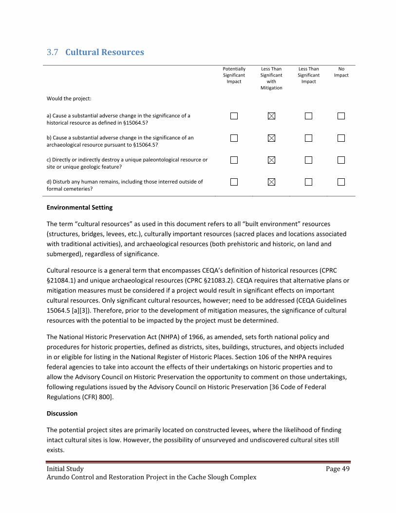
InitialStudy Page49ArundoControlandRestorationProjectintheCacheSloughComplex
CulturalResources3.7
Potentially Significant Impact
Less Than Significant
with Mitigation
Less Than Significant Impact
No Impact
Would the project:
a) Cause a substantial adverse change in the significance of a historical resource as defined in §15064.5?
b) Cause a substantial adverse change in the significance of an archaeological resource pursuant to §15064.5?
c) Directly or indirectly destroy a unique paleontological resource or site or unique geologic feature?
d) Disturb any human remains, including those interred outside of formal cemeteries?
Environmental Setting
The term “cultural resources” as used in this document refers to all “built environment” resources
(structures, bridges, levees, etc.), culturally important resources (sacred places and locations associated
with traditional activities), and archaeological resources (both prehistoric and historic, on land and
submerged), regardless of significance.
Cultural resource is a general term that encompasses CEQA’s definition of historical resources (CPRC
§21084.1) and unique archaeological resources (CPRC §21083.2). CEQA requires that alternative plans or
mitigation measures must be considered if a project would result in significant effects on important
cultural resources. Only significant cultural resources, however; need to be addressed (CEQA Guidelines
15064.5 [a][3]). Therefore, prior to the development of mitigation measures, the significance of cultural
resources with the potential to be impacted by the project must be determined.
The National Historic Preservation Act (NHPA) of 1966, as amended, sets forth national policy and
procedures for historic properties, defined as districts, sites, buildings, structures, and objects included
in or eligible for listing in the National Register of Historic Places. Section 106 of the NHPA requires
federal agencies to take into account the effects of their undertakings on historic properties and to
allow the Advisory Council on Historic Preservation the opportunity to comment on those undertakings,
following regulations issued by the Advisory Council on Historic Preservation [36 Code of Federal
Regulations (CFR) 800].
Discussion
The potential project sites are primarily located on constructed levees, where the likelihood of finding
intact cultural sites is low. However, the possibility of unsurveyed and undiscovered cultural sites still
exists.

InitialStudy Page50ArundoControlandRestorationProjectintheCacheSloughComplex
a) Would the project cause a substantial adverse change in the significance of a historical resource as
defined in §15064.5?
Less than Significant With Mitigation. The treatment of non‐native plants will not cause a substantial
adverse change in the significance of a historical resource. Restoration activities will disturb the top
layer of soil and have the potential to impact unknown historical resources. Mitigation measures listed
below will be incorporated to prevent any significant impact.
b) Would the project cause a substantial adverse change in the significance of an archaeological
resource pursuant to §15064.5?
Less than Significant With Mitigation. The treatment of non‐native plants will not cause a substantial
adverse change in the significance of an archaeological resource. Restoration activities will disturb the
top layer of soil and have the potential to impact unknown archaeological resources. Mitigation
measures listed below will be incorporated to prevent any significant impact.
c) Would the project directly or indirectly destroy a unique paleontological resource or site or unique
geologic feature?
Less than Significant With Mitigation. The project area (riparian areas) does not contain any unique
geologic features that have been listed in the County’s Guidelines nor does the project area support any
known geologic characteristics that have the potential to support unique geologic features. The project
will not modify any geologic features. The treatment of non‐native plants will not directly or indirectly
destroy a unique paleontological resource. Restoration activities will disturb the top layer of soil and
have the potential to impact unknown paleontological resources. Mitigation measures listed below will
be incorporated to prevent any significant impact.
d) Would the project disturb any human remains, including those interred outside of formal cemeteries?
Less than Significant With Mitigation. Although prehistoric human remains are often found outside of
formal cemeteries, they are usually found in association with villages and residential bases. Since none
of these were located within the project area, it is unlikely human remains will be disturbed. Mitigation
measures listed below will be incorporated to prevent any significant impact.
Mitigation Measures for Cultural Resources
CUL 1. If historical or unique archaeological or paleontological resources are incidentally discovered
during restoration activities, provisions will be made for a qualified archaeologist to immediately
evaluate the find. Work may continue on other parts of the project while evaluation and mitigation
takes place (CEQA Guidelines §15064.5 [f]). If the find is determined to be an historical or unique
archaeological or paleontological resource, time allotment sufficient to allow for implementation of
avoidance measures or appropriate mitigation must be available.
CUL 2. If human remains are found, such remains are subject to the provisions of California Public
Resources Health and Safety Code Section 7050.5‐7055. The requirements and procedures would be
InitialStudy Page51ArundoControlandRestorationProjectintheCacheSloughComplex
implemented, including immediately stopping work in the vicinity of the find and notification of the
County Coroner. The process for notification of the NAHC and consultation with the individual(s)
identified by the NAHC as the “most likely descendent” is set forth in Section 5097.98 of the California
Public Resources Code. Work can restart after the remains have been investigated and appropriate
recommendations have been made for the treatment and disposition of the remains.

InitialStudy Page52ArundoControlandRestorationProjectintheCacheSloughComplex
GeologyandSoils3.8
Potentially Significant Impact
Less Than Significant with
Mitigation
Less Than Significant Impact
No Impact
Would the project:
a) Expose people or structures to potential substantial adverse effects, including the risk of loss, injury, or death involving:
i) Rupture of a known earthquake fault, as delineated on the most recent Alquist‐Priolo Earthquake Fault Zoning Map issued by the State Geologist for the area or based on other substantial evidence of a known fault? Refer to Division of Mines and Geology Special Publication 42?
ii) Strong seismic ground shaking?
iii) Seismic‐related ground failure, including liquefaction?
iv) Landslides?
b) Result in substantial soil erosion or the loss of topsoil?
c) Be located on a geologic unit or soil that is unstable, or that would become unstable as a result of the project, and potentially result in on‐ or off‐site landslide, lateral spreading, subsidence, liquefaction or collapse?
d) Be located on expansive soil, as defined in Table 18‐1‐B of the Uniform Building Code (1994), creating substantial risks to life or property?
e) Have soils incapable of adequately supporting the use of septic tanks or alternative waste water disposal systems where sewers are not available for the disposal of waste water?
Environmental Setting
The project is located in the Sacramento‐San Joaquin River Delta within the Great Valley geomorphic
province of California, a wide alluvial plain bounded to the east by the Sierra Nevada mountain range
and to the west by the Coast Range mountain range (California Geologic Survey 2002). The geology of
the project area is dominated by Quaternary (1.8 million years ago – present) basin deposits and
alluvium eroded from the adjacent mountain ranges. Hydraulic mining debris generated during the gold
rush in the mid to late 1800s also has contributed significant material to the vicinity as hundreds of
millions of tons of silt washed down from the Sierra Nevada and deposited within the Delta. The soils in
the project area are dominated by moderately to poorly drained, alluvial clay soils.

InitialStudy Page53ArundoControlandRestorationProjectintheCacheSloughComplex
Discussion
a) Expose people or structures to potential substantial adverse effects, including the risk of loss, injury,
or death involving i) through iv) above?
No Impact. This project area does not fall within an Alquist‐Priolo Earthquake Fault Zone, Seismic Hazard
Mapping Act Zone, or Landslide Hazard Map Zone, as shown on the California Geological Survey seismic
hazard online mapping system at: http://www.quake.ca.gov/gmaps/WH/regulatorymaps.htm
b) Result in substantial soil erosion or the loss of topsoil?
Less than Significant Impact. Where restoration occurs, sites will be pre‐irrigated to promote
understory establishment to secure the topsoil prior to flood season. Therefore, it has been determined
that the project will not result in substantial soil erosion or the loss of topsoil.
c) Be located on a geologic unit or soil that is unstable, or that would become unstable as a result of the
project, and potentially result in on‐ or off‐site landslide, lateral spreading, subsidence, liquefaction or
collapse?
No Impact. The project area is not located near unstable geologic units. The activities on the site would
not result in onsite or offsite landslides, lateral spreading, liquefaction, or collapse.
d) Be located on expansive soil, as defined in Table 18‐1‐B of the Uniform Building Code (1994), creating
substantial risks to life or property?
No Impact. Soils in the project area are mostly fine grained (silt and clay). Expansive soils may be
encountered within the project area; however, the project will not have any significant impacts because
the project does not involve construction of structures or landform alteration. Therefore, the project will
not create a substantial risk to life or property.
e) Have soils incapable of adequately supporting the use of septic tanks or alternative waste water
disposal systems where sewers are not available for the disposal of waste water?
No Impact. The proposed project does not involve the use of septic tanks or alternative wastewater
disposal systems since no wastewater will be generated. Therefore, no impacts would result with
implementation of the project.
InitialStudy Page54ArundoControlandRestorationProjectintheCacheSloughComplex
GreenhouseGasEmissions3.9
Potentially
Significant Impact Less Than
Significant with Mitigation
Less Than Significant Impact
No Impact
Would the project:
a) Generate greenhouse gas emissions, either directly or indirectly, that may have a significant impact on the environment?
b) Conflict with an applicable plan, policy or regulation adopted for the purpose of reducing the emissions of greenhouse gases?
Environmental Setting
Greenhouse gases (GHGs) are recognized by wide consensus among the scientific community to
contribute to global warming/climate change and associated environmental impacts because of their
ability to trap heat in the atmosphere and affect climate. The major GHGs that are released from human
activity include carbon dioxide, methane, and nitrous oxide (Governor’s Office of Planning and Research
2008). The primary sources of GHGs are vehicles (including planes and trains), energy plants, and
industrial and agricultural activities (such as dairies and hog farms).
California has demonstrated its intent to address global climate change through research, adaptation,
and GHG inventory reductions. In response, the California Legislature enacted the California Global
Warming Solutions Act of 2006 (AB 32, Health and Safety Code Section 38500 et seq.) to implement
standards that will reduce GHG emissions to 1990 levels. In the act, the Legislature found that “[g]lobal
warming poses a serious threat to the economic well‐being, public health, natural resources, and the
environment of California.” Senate Bill 97, adopted in 2007, required the Governor’s Office of Planning
and Research to develop CEQA guidelines “for the mitigation of greenhouse gas emissions or the effects
of greenhouse gas emissions,” and the Resources Agency certified and adopted the amendments to the
guidelines on December 30, 2009. The Yolo‐Solano Air Quality Management District (YSAQMD) has not
established guidelines for evaluating GHG emissions from proposed projects and does not have
thresholds for assessing the significance of impacts.
Discussion
a) Generate greenhouse gas emissions, either directly or indirectly, that may have a significant impact
on the environment?
Less than Significant Impact. Emissions of GHGs from the project would be produced from the
restoration‐related equipment emissions and vehicle use. The project would not result in the generation
of emissions after project implementation is complete. Emissions of GHGs resulting from the use of
equipment and vehicles would be short‐term and minor. While the project would have an incremental
InitialStudy Page55ArundoControlandRestorationProjectintheCacheSloughComplex
contribution within the context of the county and region, the individual impact is considered less than
significant.
b) Conflict with an applicable plan, policy or regulation adopted for the purpose of reducing the
emissions of greenhouse gases?
No Impact. The project would not generate significant emissions of GHGs and, therefore, would not
conflict with any applicable plans, policies, or regulations adopted for the purpose of reducing the
emission of GHGs. This project is consist with the Conservancy’s Climate Change Policy.
Best Management Practices to Reduce Greenhouse Gas Emissions
The following BMPs will be implemented to minimize the emissions from this project:
GHG 1. Minimize idling time by requiring that equipment be shut down after five minutes when not in
use (as required by the State airborne toxics control measure.
GHG 2. Maintain all construction equipment in proper working condition and perform all preventative
maintenance. Required maintenance includes compliance with all manufacturer’s recommendations,
proper upkeep and replacement of filters and mufflers, and maintenance of all engine and emissions
systems in proper operating condition.
GHG 3. Develop a project specific ride share program to encourage carpools for worker commutes.

InitialStudy Page56ArundoControlandRestorationProjectintheCacheSloughComplex
HazardsandHazardousMaterials3.10
Potentially Significant Impact
Less Than Significant with
Mitigation
Less Than Significant Impact
No Impact
Would the project:
a) Create a significant hazard to the public or the environment through the routine transport, use, or disposal of hazardous materials?
b) Create a significant hazard to the public or the environment through reasonably foreseeable upset and accident conditions involving the release of hazardous materials into the environment?
c) Emit hazardous emissions or handle hazardous or acutely hazardous materials, substances, or waste within one‐quarter mile of an existing or proposed school?
d) Be located on a site which is included on a list of hazardous materials sites compiled pursuant to Government Code Section 65962.5 and, as a result, would it create a significant hazard to the public or the environment?
e) For a project located within an airport land use plan or, where such a plan has not been adopted, within two miles of a public airport or public use airport, would the project result in a safety hazard for people residing or working in the project area?
f) For a project within the vicinity of a private airstrip, would the project result in a safety hazard for people residing or working in the project area?
g) Impair implementation of or physically interfere with an adopted emergency response plan or emergency evacuation plan?
h) Expose people or structures to a significant risk of loss, injury or death involving wildland fires, including where wildlands are adjacent to urbanized areas or where residences are intermixed with wildlands?
Environmental Setting
Hazardous materials are defined in Section 66260.20, Title 22 of the California code of Regulations as a
substance or combination of substances which, because of its quantity, concentration, or physical,
chemical or infectious characteristics may either (1) cause or significantly contribute to an increase in
mortality or an increase in serious, irreversible, or incapacitating reversible, illness, or (2) pose a
substantial present or potential hazard to human health or environment when improperly treated,
stored, transported, or disposed of or otherwise managed.
InitialStudy Page57ArundoControlandRestorationProjectintheCacheSloughComplex
Discussion
a) Create a significant hazard to the public or the environment through the routine transport, use, or
disposal of hazardous material?
Less than Significant Impact. Fuel and herbicides will be transported and used on site during weed
control and restoration activities. Only herbicide formulations registered with the USEPA and DPR that
are appropriate for use in the project area shall be used. No disposal of materials will occur at project
sites. To ensure that there are no significant impacts to the environment, BMP measures will be
implemented throughout project activities, including spill control and prevention, ensuring that
equipment storage and maintenance occur only in safe and appropriate areas, and regulatory
compliance of hazardous materials transport.
b) Create a significant hazard to the public or the environment through reasonably foreseeable upset
and accident conditions involving the release of hazardous materials into the environment?
Less than Significant Impact. The project will not create a significant hazard to people or the
environment due to a reasonably foreseeable accidental release of hazardous materials. The BMPs
incorporated into the project, as discussed at the end of this section, would reduce the hazards to a less
than significant level.
c) Emit hazardous emissions or handle hazardous or acutely hazardous materials, substances, or waste
within one‐quarter mile of an existing or proposed school?
No Impact. There are no schools within one‐quarter mile of the project area.
d) Be located on a site which is included on a list of hazardous materials sites compiled pursuant to
Government Code section 65962.5 and, as a result, would it create a significant hazard to the public or
the environment?
No Impact. The site is not on a list of known hazardous materials site.
e) For a project located within an airport land use plan or, where such a plan has not been adopted,
within two miles of a public airport or public use airport, would the project result in a safety hazard for
people residing or working in the project area?
No Impact. The project area is not within an airport land use planning area.
f) For a project within the vicinity of a private airstrip, would the project result in a safety hazard for
people residing or working in the project area?
No Impact. The project activities are not located within the vicinity of an airstrip.
g) Impair implementation of or physically interfere with an adopted emergency response plan or
emergency evacuation plan?
InitialStudy Page58ArundoControlandRestorationProjectintheCacheSloughComplex
No Impact. The project activities are typically in open space areas and do not necessitate closing or
blocking roads, or restricting their use. Project activity would not alter emergency response or
emergency evacuation routes.
h) Expose people or structures to a significant risk of loss, injury or death involving wildland fires,
including where wildlands are adjacent to urbanized areas or where residences are intermixed with
wildlands?
No Impact. The project will not expose people or structures to a significant risk of loss, injury or death
due to wildland fires. Contractors will provide fire extinguishers and other firefighting equipment on
site. The control of Arundo will reduce the risk of wildland fire. A significant reduction of fire risk will
occur through implementation of the project.
Best Management Practices for Hazards and Hazardous Materials
HAZ 1. During project activities, contractor shall prevent oil, grease, fuels, and other petroleum
products, toxic chemicals, and any other substances that could be deleterious to aquatic life from
contaminating the soil and/or entering waters of the state. The contractor shall immediately remove
such substances from any place where they could enter waters of the state and/or adversely affect fish
and wildlife resources. The contractor shall attempt to contain any releases or spills of such substances,
and shall report any significant spills as soon as possible to the California Emergency Management
Agency. In the event of a significant spill, work will cease immediately and workers will employ
containment methods if it is safe to do so. The Conservancy will make notifications to the appropriate
agencies within the regulatory time frames.
HAZ 2. No materials will be staged or stored on the work site in excess of one work day.
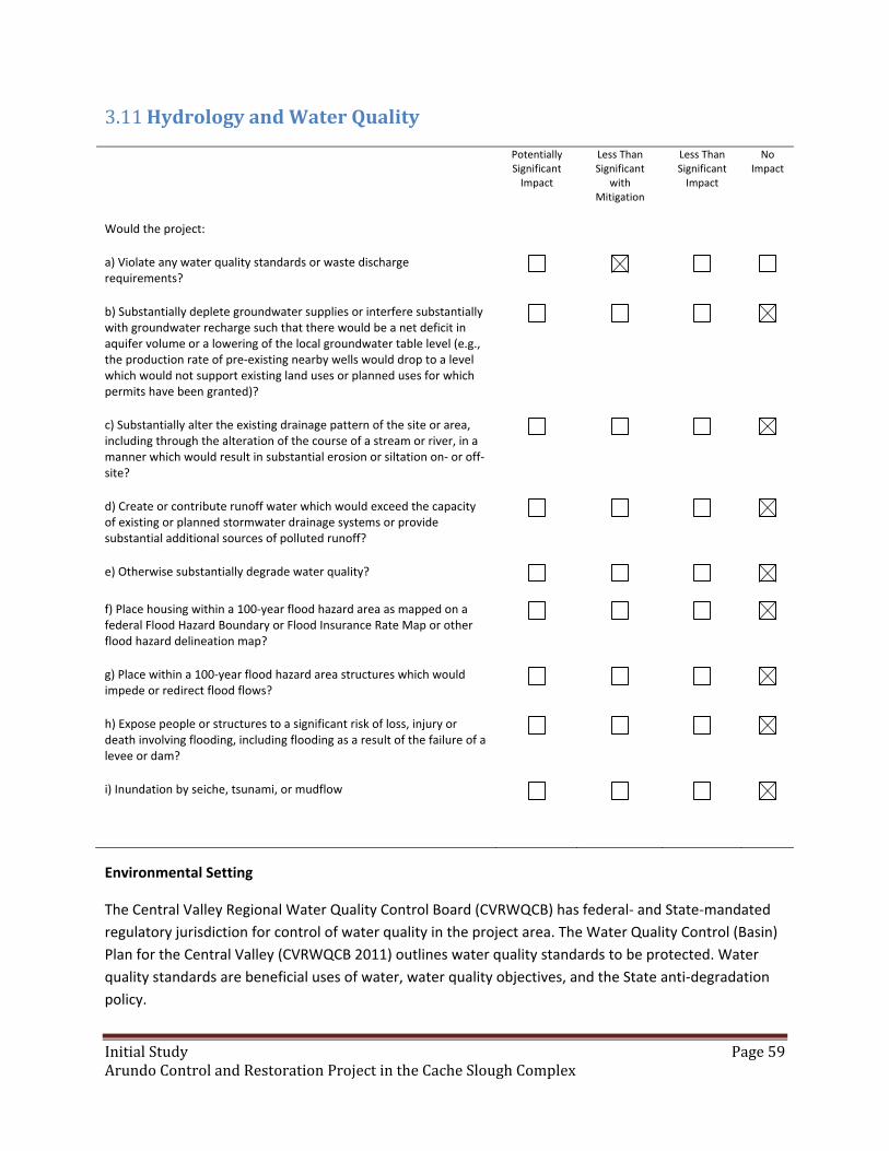
InitialStudy Page59ArundoControlandRestorationProjectintheCacheSloughComplex
HydrologyandWaterQuality3.11
Potentially Significant Impact
Less Than Significant
with Mitigation
Less Than Significant Impact
No Impact
Would the project:
a) Violate any water quality standards or waste discharge requirements?
b) Substantially deplete groundwater supplies or interfere substantially with groundwater recharge such that there would be a net deficit in aquifer volume or a lowering of the local groundwater table level (e.g., the production rate of pre‐existing nearby wells would drop to a level which would not support existing land uses or planned uses for which permits have been granted)?
c) Substantially alter the existing drainage pattern of the site or area, including through the alteration of the course of a stream or river, in a manner which would result in substantial erosion or siltation on‐ or off‐site?
d) Create or contribute runoff water which would exceed the capacity of existing or planned stormwater drainage systems or provide substantial additional sources of polluted runoff?
e) Otherwise substantially degrade water quality?
f) Place housing within a 100‐year flood hazard area as mapped on a federal Flood Hazard Boundary or Flood Insurance Rate Map or other flood hazard delineation map?
g) Place within a 100‐year flood hazard area structures which would impede or redirect flood flows?
h) Expose people or structures to a significant risk of loss, injury or death involving flooding, including flooding as a result of the failure of a levee or dam?
i) Inundation by seiche, tsunami, or mudflow
Environmental Setting
The Central Valley Regional Water Quality Control Board (CVRWQCB) has federal‐ and State‐mandated
regulatory jurisdiction for control of water quality in the project area. The Water Quality Control (Basin)
Plan for the Central Valley (CVRWQCB 2011) outlines water quality standards to be protected. Water
quality standards are beneficial uses of water, water quality objectives, and the State anti‐degradation
policy.
InitialStudy Page60ArundoControlandRestorationProjectintheCacheSloughComplex
The project area is in the Cache Slough Complex, and the waterways along which project sites may be
located include Ulatis Creek, Cache Slough, Haas Slough, Lindsey Slough, Shag Slough, Liberty Cut, and
Prospect Slough. The hydrology of the project area is complex, being influenced by different drivers in
different times of the year. Since the project area is located partial within the Yolo Bypass, it is subject to
regular winter (October through May) flooding as part of the Yolo Bypass flood control project. Outside
of the discrete flood events the site hydrology is influenced by more local factors including the Cache‐
Liberty Slough tidal system and agricultural irrigation activities in the region.
Discussion
a) Violate any water quality standards or waste discharge requirements?
Less than Significant with Mitigation. It is possible that the impacts to water quality standards could
conceivably occur from possible overspray of herbicides into receiving waters or a temporary and small
area‐limited increase in turbidity and the amounts of suspended material in the receiving water from
runoff from disturbed soils during site preparation activities for restoration. The likelihood and severity
of possible impacts to the water quality standards will be reduced to less than significant or eliminated
by use of Mitigation Measures listed at the end of this section.
b) Substantially deplete groundwater supplies or interfere substantially with groundwater recharge such
that there would be a net deficit in aquifer volume or a lowering of the local groundwater table level
(e.g., the production rate of pre‐existing nearby wells would drop to a level that would not support
existing land uses or planned uses for which permits have been granted)?
No Impact. Project activities will not affect groundwater quality, supplies, or recharge. No wells will be
drilled, no pumping will occur, and no new facilities will be created that could affect groundwater.
c) Substantially alter the existing drainage pattern of the site or area, including through the alteration of
the course of a stream or river, in a manner which would result in substantial erosion or siltation on‐ or
off‐site?
No Impact. Project activities will not alter the existing drainage pattern of the site or project area, nor
alter the course of waterways in the project area.
d) Create or contribute runoff water which would exceed the capacity of existing or planned storm
water drainage systems or provide substantial additional sources of polluted runoff?
No Impact. The project will take place on levees and it will not contribute runoff to any storm water
drainage system.
e) Otherwise substantially degrade water quality?
No Impact. See answer and elaboration to possible ompact (a). No additional impacts to water quality
are anticipated.
InitialStudy Page61ArundoControlandRestorationProjectintheCacheSloughComplex
f) Place housing within a 100‐year flood hazard area as mapped on a federal Flood Hazard Boundary or
Flood Insurance Rate Map or other flood hazard delineation map?
No Impact. The project does not construct houses.
g) Place within a 100‐year flood hazard area structures which would impede or redirect flood flows?
No Impact. The project does not involve the constructions of any structures.
h) Expose people or structures to a significant risk of loss, injury or death involving flooding, including
flooding as a result of the failure of a levee or dam?
No Impact. The project does not involve the creation of any structures, levees, or dams. The project will
not increase the likelihood of catastrophic flood events. Arundo biomass is a barrier to water flow that
can contribute to flooding. This project will reduce Arundo biomass therefore resulting in restoring
channel/flow capacity and reducing vegetation that blocks and diverts flows, which would reduce the
frequency and intensity of floods.
i) Inundate by seiche, tsunami, or mudflow?
No Impact. The area is flat and located away from the coast and foothills. It is not conceivably subject to
inundation by large waves or mud flows.
Mitigation Measures for Hydrology/Water Quality
WQ1. Activities will not be conducted on the edge of the streambank that would discharge sediment to
the waterway. Prepared soil will be pre‐irrigated to encourage native grass establishment prior to flood
season to prevent soil from being washed into the waterway if flood surface water elevations were to be
high enough to inundate the project site.
WQ2. If pre‐irrigation prior to flood season becomes unfeasible, then a straw mulch (either native grass
or rice) will be sprayed onto the site with a straw blower at the rate of 20 bales/acre to provide
increased soil structure and minimize rain drop erosion.
WQ3. Plant eradication activities near the streambank will be completed between June 15 and
November 1, or until the first major rainfall event.
WQ4. A site‐specific Spill Prevention and Response Plan shall be prepared. This plan shall include the
following:
materials handling procedures, including procedure for refilling herbicide equipment and
refueling of portable equipment in contained area or with the use of barriers to contain
spills;
storage requirements;
location of staging areas;

InitialStudy Page62ArundoControlandRestorationProjectintheCacheSloughComplex
spill cleanup procedures and processes in which spills may potentially occur;
location of an onsite spill containment and cleanup kit; and
notification procedures and contacts for use in the event of a spill.
WQ5. Only herbicide formulations registered with the USEPA and the DPR that are appropriate for use
in aquatic areas present in the project area (as determined by label requirements) shall be used.
WQ6.A certified herbicide applicator who holds a current DPR QAL or a QAC shall supervise all herbicide
applications.
WQ7. A DPR licensed PCA shall prepare a written recommendation for the use of herbicides on the
project.
WQ8. Herbicides will be applied under controlled circumstances following all manufacturers’ label
requirements, as directed by the PCA recommendation, and following all DPR regulations.
WQ9. All service containers used to store herbicide formulations and solutions shall be clearly labeled
with the herbicide type and concentration of active ingredient and stored according to best
management practices.
WQ10. Herbicides shall be applied with an appropriate biodegradable dye to facilitate visual control of
application to ensure the herbicide is not sprayed, or does not drift, into the stream. Care will be taken
by the applicator to avoid spraying open water or non‐target species.
WQ11. Cut stump herbicide applications will be made to small Arundo patches and to patches or
portions of patches where foliar spray is unfeasible or difficult to avoid overspray on water. Cut stump
applications will also be used as a follow‐up application in dense vegetation or revegetation sites where
overspray or drift pose a risk to surrounding native plants or other sensitive species.
WQ12. Herbicide shall not be applied using foliar application when conditions during winds are greater
than 10 miles per hour or if air temperature exceeds volatilization limits of herbicide.
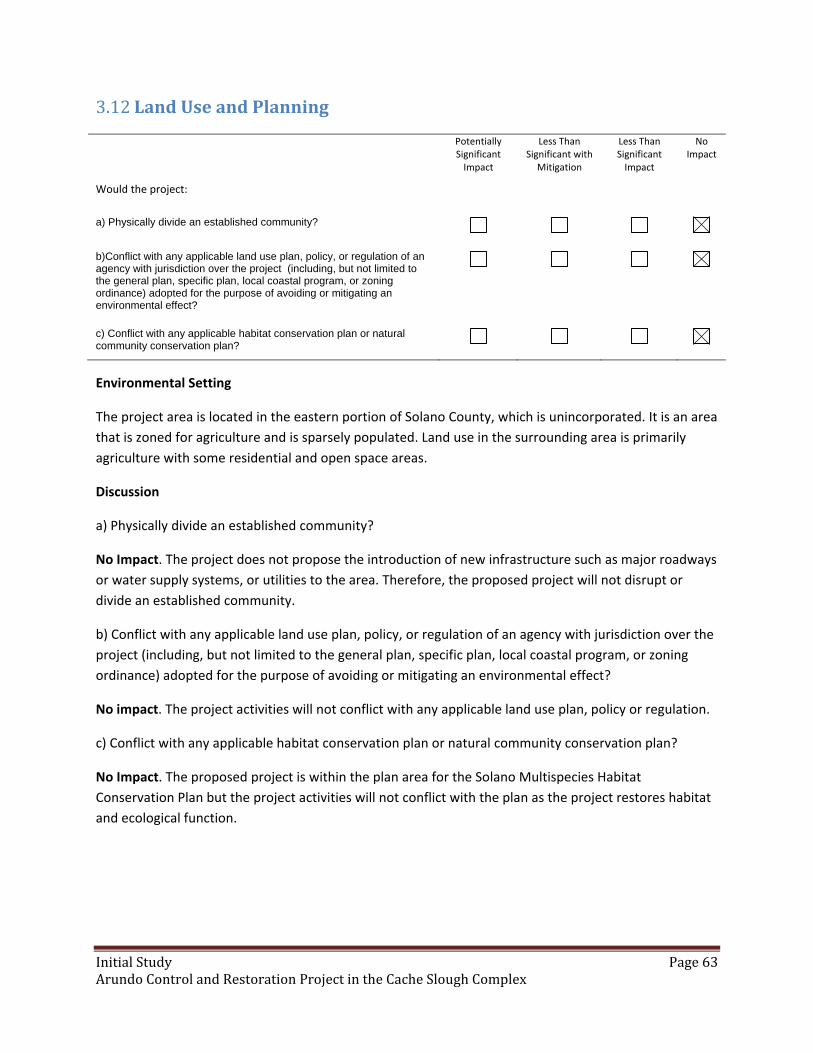
InitialStudy Page63ArundoControlandRestorationProjectintheCacheSloughComplex
LandUseandPlanning3.12
Potentially Significant Impact
Less Than Significant with
Mitigation
Less Than Significant Impact
No Impact
Would the project:
a) Physically divide an established community?
b)Conflict with any applicable land use plan, policy, or regulation of an agency with jurisdiction over the project (including, but not limited to the general plan, specific plan, local coastal program, or zoning ordinance) adopted for the purpose of avoiding or mitigating an environmental effect?
c) Conflict with any applicable habitat conservation plan or natural community conservation plan?
Environmental Setting
The project area is located in the eastern portion of Solano County, which is unincorporated. It is an area
that is zoned for agriculture and is sparsely populated. Land use in the surrounding area is primarily
agriculture with some residential and open space areas.
Discussion
a) Physically divide an established community?
No Impact. The project does not propose the introduction of new infrastructure such as major roadways
or water supply systems, or utilities to the area. Therefore, the proposed project will not disrupt or
divide an established community.
b) Conflict with any applicable land use plan, policy, or regulation of an agency with jurisdiction over the
project (including, but not limited to the general plan, specific plan, local coastal program, or zoning
ordinance) adopted for the purpose of avoiding or mitigating an environmental effect?
No impact. The project activities will not conflict with any applicable land use plan, policy or regulation.
c) Conflict with any applicable habitat conservation plan or natural community conservation plan?
No Impact. The proposed project is within the plan area for the Solano Multispecies Habitat
Conservation Plan but the project activities will not conflict with the plan as the project restores habitat
and ecological function.

InitialStudy Page64ArundoControlandRestorationProjectintheCacheSloughComplex
MineralResources3.13
Potentially Significant Impact
Less Than Significant with
Mitigation
Less Than Significant Impact
No Impact
Would the project:
a) Result in the loss of availability of a known mineral resource that would be of value to the region and the residents of the state?
b) Result in the loss of availability of a locally‐important mineral resource recovery site delineated on a local general plan, specific plan or other land use plan?
Environmental Setting
Mineral resources mined or produced within Solano County include mercury, sand, gravel, clay, stone
products, calcium, and sulfur. None of these resources are mined or produced in the project area. There
are no active mines or mineral processing facilities and no recorded past mine locations in the project
area. There are no Mineral resource zones (MRZ) within the project vicinity.
Discussion
a) Result in the loss of availability of a known mineral resource that would be of value to the region and
the residents of the state?
No impact. The proposed project will not be extracting large amounts of earthen material. At most,
minor surface disturbance for planting activities will be performed. Therefore, the proposed project will
not have any impacts on mineral resources.
b) Result in the loss of availability of a locally important mineral resource recovery site delineated on a
local general plan, specific plan or other land use plan?
No impact. See paragraph above under Section a).

InitialStudy Page65ArundoControlandRestorationProjectintheCacheSloughComplex
Noise3.14
Potentially Significant Impact
Less Than Significant with
Mitigation
Less Than Significant Impact
No Impact
Would the project result in:
a) Exposure of persons to or generation of noise levels in excess of standards established in the local general plan or noise ordinance, or applicable standards of other agencies?
b) Exposure of persons to or generation of excessive groundborne vibration or groundborne noise levels?
c) A substantial permanent increase in ambient noise levels in the project vicinity above levels existing without the project?
d) A substantial temporary or periodic increase in ambient noise levels in the project vicinity above levels existing without the project?
e) For a project located within an airport land use plan or, where such a plan has not been adopted, within two miles of a public airport or public use airport, would the project expose people residing or working in the project area to excessive noise levels?
f) For a project within the vicinity of a private airstrip, would the project expose people residing or working in the project area to excessive noise levels?
Environmental Setting
Noise‐ and vibration‐sensitive land uses generally include those uses where exposure would result in
adverse effects (e.g., sleep disturbance, annoyance), as well as uses where quiet is an essential element
of their intended purpose. Residences are of primary concern because of the potential for increased and
prolonged exposure of individuals to both interior and exterior noise levels. Other sensitive land uses
include hospitals, convalescent facilities, parks, hotels, churches, libraries, and other uses where low
interior noise levels are essential. The project area is an isolated agricultural area. There are no sensitive
receptors in close proximity to the project sites.
Discussion
a) Exposure of persons to or generation of noise levels in excess of standards established in the local
genenal plan or noise ordinance, or applicable standards of other agencies?
No Impact. Noise generated from the restoration activities are insignificant due to their short duration
and low levels in comparison to highway/road noise and surrounding land uses (agricultural operations –
which use similar types of equipment). In addition most activities are within undeveloped/open space
areas adjacent to agricultural operations which have limited or no public use/access. Furthermore, there

InitialStudy Page66ArundoControlandRestorationProjectintheCacheSloughComplex
are few residences or businesses in the project area. Therefore, the proposed project will not expose
people to or generate any noise levels that exceed the allowable limits set by Solano County or Noise
Ordinances, and other applicable local, State, and Federal noise control regulations.
b) Exposure of persons to or generation of excessive ground‐borne vibrations or ground‐borne noise
levels?
No Impact. Equipment utilized does not have the potential to generate excessive ground‐borne
vibration or noise levels.
c) A substantial permanent increase in ambient noise levels in the project vicinity above levels existing
without the project?
No Impact. The proposed project will not result in any permanent increases in ambient noise levels. The
project is short‐term in duration.
d) A substantial temporary or periodic increase in ambient noise levels in the project vicinity above
levels existing without the project?
No Impact. The proposed project will increase ambient noise levels in the project vicinity for a short
duration, but noise levels will not be in excess of established standards.
e) For a project located within an airport land use plan or, where such a plan has not been adopted,
within two miles of a public airport or public use airport, would the project expose people residing or
working in the area to excessive noise levels?
No Impact. The closest municipal airport is approximately 2 miles from the southern end of the project
area. The area is sparsely populated and project activities will not expose people in the area to excessive
noise levels.
f) For a project within the vicinity of a private airstrip, would the project expose people residing or
working in the project area to excessive noise levels?
No Impact. There are no known private airstrips nearby.

InitialStudy Page67ArundoControlandRestorationProjectintheCacheSloughComplex
PopulationandHousing3.15
Potentially Significant Impact
Less Than Significant with
Mitigation
Less Than Significant Impact
No Impact
Would the project:
a) Induce substantial population growth in an area, either directly (for example, by proposing new homes and businesses) or indirectly (for example, through extension of roads or other infrastructure)?
b) Displace substantial numbers of existing housing, necessitating the construction of replacement housing elsewhere?
c) Displace substantial numbers of people, necessitating the construction of replacement housing elsewhere?
Environmental Setting
The project area is located in the eastern portion of Solano County, which is unincorporated. It is an area
that is zoned for agriculture and is sparsely populated. There are few residences within the project
vicinity.
Discussion
a) Induce substantial population growth in an area, either directly (for example, by proposing new
homes and businesses) or indirectly (for example, through extension of roads or other infrastructure)?
No Impact. The proposed project would not directly or indirectly induce population growth. The
proposed project would not induce new employment. No new housing or extension of major
infrastructure would result.
b) Displace substantial numbers of existing housing, necessitating the construction of replacement
housing elsewhere?
No Impact. The proposed project does not have the potential to displace housing.
c) Displace substantial numbers of people, necessitating the construction of replacement housing
elsewhere?
No Impact. The project activities will not displace any people.
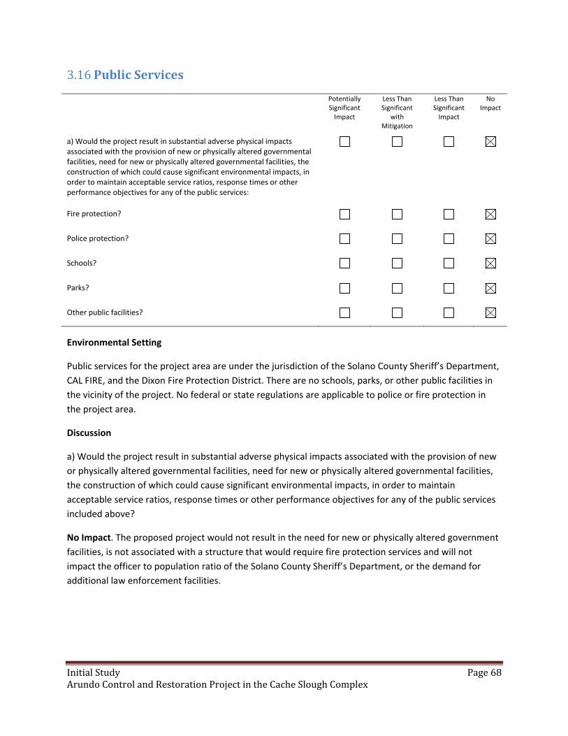
InitialStudy Page68ArundoControlandRestorationProjectintheCacheSloughComplex
PublicServices3.16
Potentially Significant Impact
Less Than Significant
with Mitigation
Less Than Significant Impact
No Impact
a) Would the project result in substantial adverse physical impacts associated with the provision of new or physically altered governmental facilities, need for new or physically altered governmental facilities, the construction of which could cause significant environmental impacts, in order to maintain acceptable service ratios, response times or other performance objectives for any of the public services:
Fire protection?
Police protection?
Schools?
Parks?
Other public facilities?
Environmental Setting
Public services for the project area are under the jurisdiction of the Solano County Sheriff’s Department,
CAL FIRE, and the Dixon Fire Protection District. There are no schools, parks, or other public facilities in
the vicinity of the project. No federal or state regulations are applicable to police or fire protection in
the project area.
Discussion
a) Would the project result in substantial adverse physical impacts associated with the provision of new
or physically altered governmental facilities, need for new or physically altered governmental facilities,
the construction of which could cause significant environmental impacts, in order to maintain
acceptable service ratios, response times or other performance objectives for any of the public services
included above?
No Impact. The proposed project would not result in the need for new or physically altered government
facilities, is not associated with a structure that would require fire protection services and will not
impact the officer to population ratio of the Solano County Sheriff’s Department, or the demand for
additional law enforcement facilities.
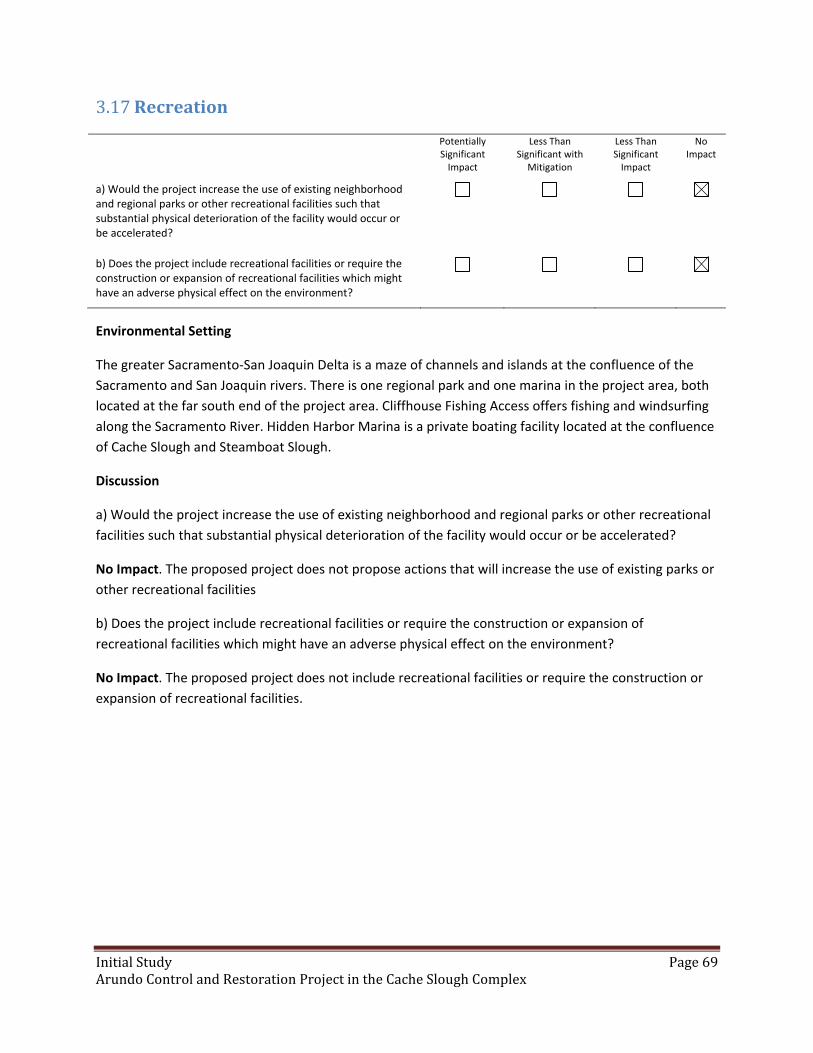
InitialStudy Page69ArundoControlandRestorationProjectintheCacheSloughComplex
Recreation3.17
Potentially Significant Impact
Less Than Significant with
Mitigation
Less Than Significant Impact
No Impact
a) Would the project increase the use of existing neighborhood and regional parks or other recreational facilities such that substantial physical deterioration of the facility would occur or be accelerated?
b) Does the project include recreational facilities or require the construction or expansion of recreational facilities which might have an adverse physical effect on the environment?
Environmental Setting
The greater Sacramento‐San Joaquin Delta is a maze of channels and islands at the confluence of the
Sacramento and San Joaquin rivers. There is one regional park and one marina in the project area, both
located at the far south end of the project area. Cliffhouse Fishing Access offers fishing and windsurfing
along the Sacramento River. Hidden Harbor Marina is a private boating facility located at the confluence
of Cache Slough and Steamboat Slough.
Discussion
a) Would the project increase the use of existing neighborhood and regional parks or other recreational
facilities such that substantial physical deterioration of the facility would occur or be accelerated?
No Impact. The proposed project does not propose actions that will increase the use of existing parks or
other recreational facilities
b) Does the project include recreational facilities or require the construction or expansion of
recreational facilities which might have an adverse physical effect on the environment?
No Impact. The proposed project does not include recreational facilities or require the construction or
expansion of recreational facilities.
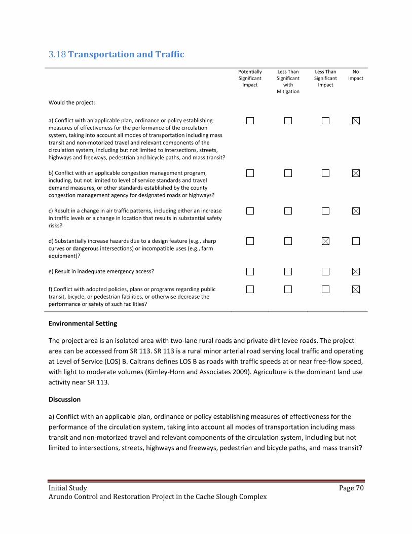
InitialStudy Page70ArundoControlandRestorationProjectintheCacheSloughComplex
TransportationandTraffic3.18
Potentially Significant Impact
Less Than Significant
with Mitigation
Less Than Significant Impact
No Impact
Would the project:
a) Conflict with an applicable plan, ordinance or policy establishing measures of effectiveness for the performance of the circulation system, taking into account all modes of transportation including mass transit and non‐motorized travel and relevant components of the circulation system, including but not limited to intersections, streets, highways and freeways, pedestrian and bicycle paths, and mass transit?
b) Conflict with an applicable congestion management program, including, but not limited to level of service standards and travel demand measures, or other standards established by the county congestion management agency for designated roads or highways?
c) Result in a change in air traffic patterns, including either an increase in traffic levels or a change in location that results in substantial safety risks?
d) Substantially increase hazards due to a design feature (e.g., sharp curves or dangerous intersections) or incompatible uses (e.g., farm equipment)?
e) Result in inadequate emergency access?
f) Conflict with adopted policies, plans or programs regarding public transit, bicycle, or pedestrian facilities, or otherwise decrease the performance or safety of such facilities?
Environmental Setting
The project area is an isolated area with two‐lane rural roads and private dirt levee roads. The project
area can be accessed from SR 113. SR 113 is a rural minor arterial road serving local traffic and operating
at Level of Service (LOS) B. Caltrans defines LOS B as roads with traffic speeds at or near free‐flow speed,
with light to moderate volumes (Kimley‐Horn and Associates 2009). Agriculture is the dominant land use
activity near SR 113.
Discussion
a) Conflict with an applicable plan, ordinance or policy establishing measures of effectiveness for the
performance of the circulation system, taking into account all modes of transportation including mass
transit and non‐motorized travel and relevant components of the circulation system, including but not
limited to intersections, streets, highways and freeways, pedestrian and bicycle paths, and mass transit?
InitialStudy Page71ArundoControlandRestorationProjectintheCacheSloughComplex
No Impact. The proposed project will not conflict with any applicable plans, ordinances, or policy
establishment performance of circulation systems.
b) Conflict with an applicable congestion management program, including, but not limited to level of
service standards and travel demand measures, or other standards established by the county congestion
management agency for designated roads or highways?
No Impact. The proposed project will not conflict with any congestion management plans.
c) Result in a change in air traffic patterns, including either an increase in traffic levels or a change in
location that results in substantial safety risks?
No Impact. The proposed project would not affect air patterns.
d) Substantially increase hazards due to a design feature (e.g., sharp curves or dangerous intersections)
or incompatible uses (e.g., farm equipment)?
Less than Significant Impact. The project will not alter traffic patterns, roadway design, create or place
curves, slopes or walls which impede adequate sight distance on a road, or cause significant
traffic/transportation hazards. Work crews will use tractors and other equipment, but in unimproved
areas and staging areas. Any temporary movement of equipment or work near roads will be signed and
standard BMP/safety procedures will be followed: flagmen, traffic control, etc. Crews will not stop or
divert traffic.
e) Result in inadequate emergency access?
No Impact. The proposed project does not propose changes to access in the surrounding area and will
not result in inadequate emergency access.
f) Conflict with adopted policies, plans or programs regarding public transit, bicycle, or pedestrian
facilities, or otherwise decrease the performance or safety of such facilities?
No Impact. Project implementation will not result in any construction or new road design features;
therefore, will not conflict with policies regarding alternative transportation.

InitialStudy Page72ArundoControlandRestorationProjectintheCacheSloughComplex
UtilitiesandServiceSystems3.19
Potentially Significant Impact
Less Than Significant with
Mitigation
Less Than Significant Impact
No Impact
Would the project:
a) Exceed wastewater treatment requirements of the applicable Regional Water Quality Control Board?
b) Require or result in the construction of new water or wastewater treatment facilities or expansion of existing facilities, the construction of which could cause significant environmental effects?
c) Require or result in the construction of new storm water drainage facilities or expansion of existing facilities, the construction of which could cause significant environmental effects?
d) Have sufficient water supplies available to serve the project from existing entitlements and resources, or are new or expanded entitlements needed?
e) Result in a determination by the wastewater treatment provider which serves or may serve the project that it has adequate capacity to serve the project’s projected demand in addition to the provider’s existing commitments?
f) Be served by a landfill with sufficient permitted capacity to accommodate the project’s solid waste disposal needs?
g) Comply with federal, state, and local statutes and regulations related to solid waste?
Environmental Setting
The project is located in a remote part of the county and there are no utility or service systems for the
project sites.
Discussion
a) Exceed wastewater treatment requirements of the applicable Regional Water Quality Control Board?
No Impact. The proposed project does not involve any uses that will discharge any wastewater to
sanitary sewer or on‐site wastewater systems (septic). Therefore, the project will not exceed any
wastewater treatment requirements.
b) Require or result in the construction of new water or wastewater treatment facilities or expansion of
existing facilities, the construction of which could cause significant environmental effects?
InitialStudy Page73ArundoControlandRestorationProjectintheCacheSloughComplex
No Impact. The proposed project does not include new or expanded water or wastewater treatment
facilities. In addition, the project does not require the construction or expansion of water or wastewater
treatment facilities. Therefore, the project will not require any construction of new or expanded
facilities that could cause significant environmental effects.
c) Require or result in the construction of new storm water drainage facilities or expansion of existing
facilities, the construction of which could cause significant environmental effects?
No Impact. The proposed project does not include or require new or expanded storm water drainage
facilities.
d) Have sufficient water supplies available to serve the project from existing entitlements and resources,
or are new or expanded entitlements needed?
No Impact. The proposed project will not change existing water supplies available.
e) Result in a determination by the wastewater treatment provider which serves or may serve the
project that it has adequate capacity to serve the project’s projected demand in addition to the
provider’s existing commitments?
No Impact. The proposed project does not use sewer services or generate waste water. Therefore,
wastewater treatment is not applicable to the project.
f) Be served by a landfill with sufficient permitted capacity to accommodate the project’s solid waste
disposal needs?
Less than Significant Impact. Arundo biomass will be left to degrade natural. Although there may be a
few sites where biomass will be removed and deposited in a landfill. However, the quantity of solid
waste will be small enough to be easily accommodated in a regional landfill. Additionally, if it is mowed
or chipped, the volume will further be reduced.
g) Comply with federal, state, and local statutes and regulations related to solid waste?
No Impact. Implementation of the project may generate solid waste. If so, all solid waste will be
deposited at a permitted solid waste facility and, therefore, will comply with Federal, State, and local
statutes and regulations related to solid waste.

InitialStudy Page74ArundoControlandRestorationProjectintheCacheSloughComplex
MandatoryFindingsofSignificance3.20
Potentially Significant Impact
Less Than Significant
with Mitigation
Less Than Significant Impact
No Impact
a) Does the project have the potential to degrade the quality of the environment, substantially reduce the habitat of a fish or wildlife species, cause a fish or wildlife population to drop below self‐sustaining levels, threaten to eliminate a plant or animal community, substantially reduce the number or restrict the range of a rare or endangered plant or animal or eliminate important examples of the major periods of California history or prehistory?
b) Does the project have impacts that are individually limited, but cumulatively considerable? ("Cumulatively considerable" means that the incremental effects of a project are considerable when viewed in connection with the effects of past projects, the effects of other current projects, and the effects of probable future projects)?
c) Does the project have environmental effects which will cause substantial adverse effects on human beings, either directly or indirectly?
Discussion
This Initial Study was prepared to assess the proposed project’s potential effects on the environment
and significance of those effects. Based on the Initial Study, it has been determined that the proposed
project would not have any significant environmental effects and will have less‐than‐significant
cumulative impacts. The potential, short‐term adverse environmental effects related to restoration and
Arundo control activities would be minimized or avoided through the implementation of environmental
commitments that have been incorporated into the project description.
a) Does the project have the potential to degrade the quality of the environment, substantially reduce
the habitat of a fish or wildlife species, cause a fish or wildlife population to drop below self‐sustaining
levels, threaten to eliminate a plant or animal community, reduce the number or restrict the range of a
rare or endangered plant or animal or eliminate important examples of the major periods of California
history or prehistory?
Less than Significant with Mitigation. The project does have the potential to degrade the quality of the
environment, but will not substantially reduce the habitat of a fish or wildlife species, cause a fish or
wildlife population to drop below self‐sustaining levels, threaten to eliminate a plant or animal
community, or reduce the number of or restrict the range of a rare or endangered plant or animal or
eliminate important examples of the major periods of California history or prehistory. Mitigation
measures have been proposed to reduce impacts to less‐than‐significant levels and are described in full
detail starting on page 2 and after each resource discussion.

InitialStudy Page75ArundoControlandRestorationProjectintheCacheSloughComplex
Riparian habitats are found near the potential project sites and special status species may be found
within the project area, but no special status species will likely be significantly impacted during project
activities due to seasonal constraints on the project (i.e., project activities will take place outside of the
active season for most species). Mitigation measures will be implemented to bring environmental
impacts of the proposed activities to less‐than‐significant levels within the project area. Specifically,
potential impacts to biological resources, cultural, hydrology/water quality will be mitigated to less‐
than‐significant levels.
b) Does the project have impacts that are individually limited, but cumulatively considerable?
("Cumulatively considerable" means that the incremental effects of a project are considerable when
viewed in connection with the effects of past projects, the effects of other current projects, and the
effects of probable future projects)?
Less than Significant Impact. As discussed in the analysis provide in this Initial Study, the environmental
commitments that are incorporated into the project maintain all potential impacts on resources at a
less‐than‐significant level. The proposed project would not result in cumulatively considerable impacts.
c) Does the project have environmental effects which will cause substantial adverse effects on human
beings, either directly or indirectly?
No Impact. The proposed project would not result in substantial adverse effects on human beings.

InitialStudy Page76ArundoControlandRestorationProjectintheCacheSloughComplex
4 DocumentPreparation
The following people assisted in the preparation of this document:
Kristal Davis Fadtke, Senior Environmental Scientist
Heather White, Biologist, Conservancy Volunteer
InitialStudy Page77ArundoControlandRestorationProjectintheCacheSloughComplex
5 References
California Assembly Bill No. 32. 2006. California Global Warming Solutions Act (AB 32).
CCR (California Code of Regulations) Title 14, Chapter 3, California Code of Regulations, sections 15000
etsq. http://www.ceres.ca.gov/topic/env_law/ceqa/guidelines.
CDFW (California Department of Fish and Wildlife). 2015. California Natural Diversity Database (CNDDB).
Database query for the 7.5‐minute Quadrangles Liberty Island, Dozier, Courtland, Isleton, Rio Vista, Birds
Landing, Clarksburg, Saxon, and Dixon. Accessed: April 2015.
California Fish and Game Code Section 2050. http://www.leginfo.ca.gov/cgi‐
bin/calawquery?codesection=fgc&codebody=&hits=20
California Geologic Survey. 2002. California Geomorphic Provinces. California Geological Survey, Note
36.
CNPS (California Native Plant Society). 2015. Inventory of Rare and Endangered Plants (online edition,
v8‐02). California Native Plant Society, Sacramento, CA. Website http://www.rareplants.cnps.org
Accessed: June 2015.
CPRC (California Public Resources Code), Division 13 Environmental Quality, Chapter 2.6 General,
Sections 21083.2 and 21084.1
CDFG (California Department of Fish and Game). 1994. Amphibian and Reptile Species of Special
Concern in California.
CDFG (California Department of Fish and Game). 2005. California Department of Fish and Game project
review guidelines for Delta Smelt, winter‐run Chinook Salmon, and spring‐run Chinook Salmon
protection in the Sacramento‐San Joaquin Estuary. Prepared by the State of California, the Resources
Agency, Department of Fish and Game, Central Valley Bay‐Delta Branch.
CDFG (California Department of Fish and Game). 2008. California Bird Species of Special Concern.
CVRWQCB (Central Valley Regional Water Quality Control Board). 2011. Water Quality Control Plan
(Basin Plan) for the California Regional Water Quality Control Board Central Valley Region (4th Edition).
October 2011. http://www.waterboards.ca.gov/centralvalley/water_issues/basin_plans/index.shtml.
Governor’s Office of Planning and Research. 2008. CEQA and Climate Change: Addressing Climate
Change Through California Environmental Quality Act (CEQA) Review. http://opr.ca.gov/docs/june08‐
ceqa.pdf
Hickman, J.C., 2012. The Jepson Manual: Higher Plants of California. Berkeley, CA., University of
California Press.

InitialStudy Page78ArundoControlandRestorationProjectintheCacheSloughComplex
Kimley‐Horn Associates, Inc. 2009. State Route 113 Major Investment Study (MIS) – Final Report.
Prepared for Solano Transportation Authority, City of Dixon, and County of Solano. April 2009.
USFWS (U.S. Fish and Wildlife Service). 2004. Final programmatic consultation on the issuance of section
10 and 404 permits for projects with relatively small effects on the Delta Smelt (Hypomesus
transpacificus) and it’s Critical Habitat within the jurisdiction of the Sacramento Fish and Wildlife Office
of the U.S. Fish and Wildlife Service, California. [1‐1‐04‐F‐0345]
USFWS (U.S. Fish and Wildlife Service). 2015. Sacramento Fish and Wildlife Office. Database query:
Federal endangered and threatened species list for the Clarksburg, Courtland, Isleton, Rio Vista, Birds
Landing, Dozier, Liberty Island, Saxon, and Dixon USGS 7.5‐minute quadrangles. Accessed: April 2015.
Williams, D.F. 1986. Mammalian Species of Special Concern in California.
Yolo‐Solano Air Quality Management District Air Quality Standards Attainment Status. 2009.
http://www.ysaqmd.org/state‐plans.php.
YSAQMD (Yolo‐Solano Air Quality Management District). 2007. Handbook for Assessing and Mitigating
Air Quality Impacts. July 11, 2007. http://www.ysaqmd.org/documents/CEQAHandbook2007.pdf.
Accessed: June 2015.