
Final Draft Jul05 - Fort Benning Benn… ·...
215
FINAL DRAFT Contract No. HQ-00-PZC-013 July 2005 ENVIRONMENTAL ASSESSMENT FOR THE PROPOSED CONSTRUCTION OF A SHOPPING CENTER FORT BENNING, GEORGIA Prepared by: Operations Center P.O. Box 225887 Dallas, Texas 75222-5887 Departments of the Army and Air Force Army and Air Force Exchange Service A part of your benefits...A part of your life! 14: US ARMY/FT BENNING/Final Draft Book Cover.CDR
Transcript of Final Draft Jul05 - Fort Benning Benn… ·...

FINAL DRAFT
Contract No. HQ-00-PZC-013
July 2005ENVIRONMENTAL ASSESSMENTFOR THE
PROPOSED CONSTRUCTIONOF A
SHOPPING CENTERFORT BENNING, GEORGIA
Prepared by:
Operations CenterP.O. Box 225887Dallas, Texas 75222-5887
Departments of the Army and Air ForceArmy and Air Force Exchange Service
A part of your benefits...A part of your life!
14: US ARMY/FT BENNING/Final Draft Book Cover.CDR


001460.ES06.01_T1474
Final Draft
Environmental Assessment for the Proposed Construction
of a Shopping Center Fort Benning, Georgia
Contract No. HQ 00-PZC-013
July 2005
Prepared by:
UNITED STATES DEPARTMENTS OF THE ARMY AND AIR FORCE
Army and Air Force Exchange Service Operations Center P.O. Box 225887
Dallas, Texas 75222-5887
\\Talbdl1\publications\1400-1499\1460.ES06.01_T1474\July05 Final Draft\Final Draft Jul05.doc ES-1
Executive Summary
AGENCY: United States Army (Army).
PURPOSE: The Army has coordinated the preparation of an environmental assessment (EA) of the potential environmental consequences of constructing a proposed shopping center at Fort Benning, Georgia (the Post), as described in the next paragraph. This EA has been completed pursuant to the National Environmental Policy Act (NEPA); the Council on Environmental Quality (CEQ) regulations implementing NEPA; United States Department of Defense (DoD) Directive 6050.1 “Environmental Effects in the United States of DOD Actions;” and 32 Code of Federal Regulations (CFR) 651 (Army Regulation [AR] 200-2) “Environmental Effects of Army Actions,” which implements these regulations.
PROPOSED ACTION: The Army and Air Force Exchange Service (AAFES) proposes to construct a new shopping center for use by authorized individuals at Fort Benning. The Proposed Action would consist of construction and operation of a shopping center (Post Exchange [PX]) containing a main store, military clothing sales store, and a food court including an Anthony’s Pizza, Robin Hood Deli, Burger King, Taco Bell, Church’s Chicken, Manchu Wok, Charley’s Grilled Subs, A & W, and Baskin Robbins. Services would include a barber shop, beauty shop, pharmacy, alterations shop, optometrist/eyecare office, flower shop, one-hour photo store, nutrition center, shoe store, amusement arcade, beauty supply, collectibles, roving concessions, category enhancer, and local artisan. Recycled content products would be supplied in the PX for purchase by consumers.
New construction would consist of reinforced concrete slab/foundation with masonry/metal stud exterior walls, steel structure and built-up partitions, AAFES-provided shelving, suspended ceilings and recessed energy-efficient lighting. Construction products would meet U.S. Environmental Protection Agency recycled content requirements. Exterior support would include required utilities, communications, paving, walks, curbs, storm drainage, site improvements, electrical, mechanical, and fire protection for a complete and usable facility. Prior to construction, the Fort Benning Land Management Branch would remove all merchantable timber. Only AAFES-authorized patrons would use the facility. These patrons are primarily active duty and retired military personnel, their family members, and certain categories of reserve military personnel.
Following the construction of the proposed PX facility, Soldiers’ Support Services would be relocated to the vacated, existing PX facility (Holloway 2000). Soldiers’ Support Services is currently located in a group of World War II-era structures within an older part of the Post. Once Soldiers’ Support Services moves, the old structures formerly used by Soldiers’ Support Services would be demolished (Holloway 2000).
ALTERNATIVES: Seven action alternatives and the no-action alternative were initially considered. These alternatives included expansion of the existing building, as well as construction of the proposed new facility on five alternative sites. This also included variations of site design to minimize environmental impacts. The seven action alternatives were evaluated against specific

Executive Summary
\\Talbdl1\publications\1400-1499\1460.ES06.01_T1474\July05 Final Draft\Final Draft Jul05.doc ES-2
criteria, and four of the sites were eliminated from further consideration. One alternative complied with the criteria and is assessed, along with the no-action alternative, in this EA. The preferred site for the Proposed Action is on the north side of Marne Road, east of Interstate 185.
SUMMARY OF EFFECTS: This EA evaluated the potential environmental effects of the Proposed Action and the No-Action alternatives on the following resources: earth resources, water resources, noise, climate and air quality, hazardous materials and wastes, biological resources, land use, cultural resources, infrastructure and utilities, and socioeconomics. Potential impacts of the Proposed Action and the No-Action alternative to each environmental resource are summarized below.
Socioeconomics. Impacts to demographic compositions are not expected. Although AAFES anticipates increases of approximately 2,000 persons in the customer base at the new shopping center facility, these increases would likely not reflect compositional changes according to gender, age, or race.
The increased customer base is more likely to utilize this facility due to convenience of location and tax-free goods. Total sales volumes associated with this project could increase from current levels. Because of the distance of the nearest competing shopping centers, no major effect on the local economy is expected. The project is expected to have a minor positive economic impact for the Post and surrounding areas.
Water Resources. Construction activities at the approximately 18.25-acre site would result in the loss of natural vegetation, with the placement of impervious surface. Because of the loss of vegetation during construction activities, highly erodible soils would be exposed and the potential for soil erosion and sedimentation to the unnamed tributaries and Hamlet Creek would increase resulting in minor adverse impacts. During construction activities, the contractor would be required to implement strict erosion control measures to prevent increased sedimentation during construction in accordance with the Georgia general permit (GAR 100001).
In addition, AAFES would be required to prepare and implement a Spill Prevention, Control and Countermeasures (SPCC) Plan, which would be part of the Erosion, Sedimentation, and Pollution Control (ES&PC) Plan that would be prepared for the construction site. The SPCC Plan would delineate measures and practices that would be implemented to prevent and/or minimize spill/release from hazardous materials into water surfaces. Basic best management practices (BMPs) for pollution prevention would include monitoring of storage areas exposed to the inclement weather to ensure that pollutants are not discharged into storm drainages during construction and operation of the facility. These measures would ensure the protection of water resources thereby minimizing the impacts to water resources. Additionally, under the new Municipal Separate Storm Sewer System (MS4) requirements, the same BMPs would address pollution of water from storage areas. All facilities within the food court would meet requirements to ensure that any aboveground storage tanks for oil/grease management are properly managed and they do not discharge into the storm drains. Adherence to the above-mentioned plans and regulations would limit potential adverse effects to surface water to minor adverse effects.
Implementation of the preferred alternative (Alternative 7) would result in adverse impacts to
approximately 0.114 acres of wetlands and 26 linear feet of intermittent stream with some perennial streams, permanently converting these areas to improved land. Because of the small amount of wetlands impacted by the Proposed Action, the U.S. Army Corps of Engineers has allowed AAFES to utilize Nationwide Permit #18 for the construction of the Proposed Action. Furthermore, in
Executive Summary
\\Talbdl1\publications\1400-1499\1460.ES06.01_T1474\July05 Final Draft\Final Draft Jul05.doc ES-3
accordance with the Georgia Erosion and Sediment Control Act, a 25-foot buffer must be between any development and a defined stream channel. However, because the impacts would be associated with the road crossing for the shopping center project the Proposed Action would result in an exemption from this requirement. Although the wetlands are being permanently impacted, because of the small amount and the ability to utilize the Nationwide Permit, these impacts would be considered minor adverse impacts. No effect would occur to either groundwater resources or floodplains from the implementation of the preferred alternative.
Noise. The preferred site of the proposed action is located within Zone I, where noise sensitive receptors (i.e., housing, schools, and medical facilities) are compatible with the noise environment (Figure 2-2). Construction and land-disturbing activities would result in temporary increases in ambient noise levels at and around the construction site. Noise generators during construction include vehicles and equipment involved in site clearing and grading, construction, landscaping, and finishing work. Short-term noise impacts would continue for approximately 20 months from the commencement of site work to the end of construction activities. Also, there would be an increase in vehicular traffic noise due to the increase in visits by construction vehicles per day. Impacts can be minimized by limiting construction activity to daylight hours and by using properly maintained and muffled equipment. Noise associated with implementation of the Proposed Action at the preferred alternative site would be limited primarily to construction and would represent a localized short-term minor adverse effect and would not affect any noise sensitive receptors located greater than 50 feet away from the preferred alternative site.
Noise from operation of the new shopping center would be limited primarily to an increase in the number of vehicles in the area, including delivery trucks and patron traffic. Compared to existing noise levels, the noise levels from increased traffic activity would be expected to add a minimal increase to existing ambient noise levels within the project area, resulting in a long-term minor adverse effect. This long-term minor adverse effect would not result in incompatible noise activities to sensitive noise receptors located within Zone 1.
Air Quality. Long-term impacts to the immediate project area would occur from emissions due to an increase in deliveries and customer vehicular traffic. However, it is anticipated, that overall regional emissions associated with vehicular traffic would remain the same. Therefore, there would be no significant long-term impacts to air quality associated with the preferred alternative.
The operation of heavy equipment would have minor, temporary negative impacts on air quality during the construction phase. These impacts would be primarily in the form of increased exhaust pollutants, which can be minimized by good vehicle maintenance. Windblown soil and dust may also occur during the construction phase as a result of equipment movement over exposed soil areas. Appendix D provides additional data on air quality impacts. Fugitive dust can be greatly minimized by appropriate dust control measures such as wetting the surfaces and by re-vegetating disturbed areas as soon as possible. Therefore, the short-term air quality impacts resulting from the Proposed Action would be a temporary increase of air pollutants during construction, which would cease once the project was completed. No significant adverse impacts would result from the Proposed Action.
Earth Resources. A moderate amount of excavation and fill is anticipated within the 18.25 acre disturbed area. Short-term moderate adverse construction impacts may result in an increase in soil erosion resulting in moderate adverse impacts to soils. Any increased exposure of the Nankin soils could result in the formation of gullies and in a large volume of soil runoff. A construction National Pollutant Discharge Elimination System (NPDES) stormwater permit would be required to ensure that construction activities adhere to BMPs/other measures and would be associated with the ES&PC Plan. Erosion controls and structures for this permit would likely be extensive due to the

Executive Summary
\\Talbdl1\publications\1400-1499\1460.ES06.01_T1474\July05 Final Draft\Final Draft Jul05.doc ES-4
quality of soils present. Long-term impact would be dependent on the increase in exposure of the Nankin soils. In addition, as indicated previously, AAFES would be required to prepare and implement a SPCC Plan during construction activities and management of the facility. These measurements would ensure the protection of soil resources.
Adverse impacts from geologic hazards, including seismic shaking or subsidence, are not likely to affect this project. In addition, no known unique geologic features or mineral resources would be affected.
Infrastructure and Utilities. Implementation of the preferred alternative would result in an increase demand upon existing infrastructure and utilities. Existing infrastructure and utility services at Fort Benning have adequate capacity to accommodate the Proposed Action. However, construction of the Proposed Action would increase the volume of traffic slightly in the project area due to on-road use by construction equipment, construction workforce vehicles, and vehicles delivering construction materials. Management actions to minimize impacts from increased traffic have been included in the project design. The increase in traffic following construction is not expected to be large compared to the volume of traffic currently present in the area and is not expected to affect the current levels of service for adjacent roadways and intersections.
Hazardous Materials and Wastes. Hazardous materials, including retail-sized containers of motor oil, paints and solvents, would likely be stored at the site during operation of the new shopping center. However, these materials would be stored solely for retail sale and individual, off-site use by military personnel and their families. Any hazardous materials/waste that are accumulated would be managed and disposed of in accordance with all local, State and Federal laws and regulations, and Fort Benning hazardous waste plan to include a site-specific SPCC Plan for the facility. These would also be on-site during the construction phase of the project and must be managed in accordance with Federal and State laws and Fort Benning’s Resource Conservation and Recovery Act (RCRA) Part B Permit. No adverse effects would result from the Proposed Action.
Biological Resources. The majority of the species that currently use the area have adapted to living in urban areas and co-existing with human activity, and are mobile generalist species that utilize a variety of interspersed/fragmented habitats, range over wide areas for food and cover, and/or are migratory and would use the site seasonally. No federally or State-protected species are known to exist on or use the preferred site. No adverse effects to habitat, wildlife, and threatened and endangered species would result from the Proposed Action.
Although no foreseen direct impacts would occur, 18.25 acres of potential foraging habitat for the federally endangered red-cockaded woodpecker (RCW) would be lost. However, the preferred alternative site is not foraging habitat for any currently active clusters and is located outside the foraging circle of any inactive cluster; therefore, it is unlikely that implementation of the Proposed Action at this site, including removal of 14 RCW trees, would adversely affect the continued existence of the RCW on Fort Benning. These 14 trees are associated with abandoned cluster AA-01, which is inactive and was deleted from management in 1998; therefore, there would be no effect to threatened and endangered species from this alternative. No mitigation measures are proposed.
Cultural Resources. Based on the field visit, and past studies conducted within the area of potential effect (APE), it is unlikely that cultural resources would be directly impacted within or near the APE. Once the proposed PX facility is completed, however, Soldiers’ Support Services, which is currently located within a group of World War II-era structures would be relocated to the vacated, existing PX facility (Holloway 2000). Once Soldiers’ Support Services moves, the old structures formerly used by Soldiers’ Support Services would be demolished (Holloway 2000), which would be considered an adverse effect of the project. The demolition of these structures would be covered

Executive Summary
\\Talbdl1\publications\1400-1499\1460.ES06.01_T1474\July05 Final Draft\Final Draft Jul05.doc ES-5
under the 1986 Programmatic Memorandum of Agreement (USDOD 1986). Therefore, the implementation of the Proposed Action at the preferred alternative site would have no affect on any resources eligible for listing on the National Register of Historic Places. The State Historic Preservation Officer concurs with this assessment as presented in the concurrence letter provided in Appendix B. No mitigation measures are proposed.
Land Use. The proposed site is currently undeveloped and wooded with more woodlands to the north and east; however, the areas to the west and south are urbanized. The Proposed Action would be contained within Fort Benning, which sets its own land use and zoning designations and would not present conflicts with local or state land use or zoning designations. The proposed site is designated as “family housing” and “open space.” The construction of the proposed PX facility would change the land designation to “community.” No significant adverse impacts are anticipated from this Proposed Action, and use of the proposed site would be compatible with surrounding land uses.
NO-ACTION ALTERNATIVE: The conditions and characteristics anticipated under the no-action alternative for each of the resources at Fort Benning would continue at levels equal to those occurring under the existing condition. No significant impacts are experienced or generated by the existing condition because infrastructure can accommodate the current levels of activity. However, future levels of activity could exceed infrastructure capacity. No significant impacts would be expected for the no-action alternative.

\\Talbdl1\publications\1400-1499\1460.ES06.01_T1474\July05 Final Draft\Final Draft Jul05.doc iii
Table of Contents
Section Page
Executive Summary........................................................................................... ES-1 List of Tables........................................................................................................................................vii List of Illustrations ................................................................................................................................ ix Acronyms and Abbreviations ................................................................................................................ xi 1 Purpose of and Need for the Proposed Action........................................ 1-1
1.1 Organization of the Document ..................................................................................1-1 1.2 Description of the Proposed Action ..........................................................................1-2 1.3 Purpose and Need for the Proposed Action...............................................................1-3 1.4 Scope of the Environmental Review .........................................................................1-3 1.5 Agency Coordination and Public Participation .........................................................1-4
2 Description of the Proposed Action and Alternatives ............................ 2-1
2.1 Location of the Proposed Action...............................................................................2-1 2.2 Alternatives Development Process............................................................................2-1 2.3 Alternative Site Considered, but Eliminated from Further Review ..........................2-3 2.3.1 Alternative 1....................................................................................................2-3 2.3.2 Alternative 2....................................................................................................2-4 2.3.3 Alternative 3....................................................................................................2-7 2.3.4 Alternative 4....................................................................................................2-7 2.3.5 Alternative 5....................................................................................................2-7 2.3.6 Alternative 6....................................................................................................2-8 2.4 Actions to be Evaluated Further in the EA................................................................2-8 2.4.1 Alternative 7: New Site Design at Marne Road (Preferred Alternative).........2-8 2.4.2 Alternative 8: The No-Action Alternative (Status Quo) .................................2-9
3 Affected Environment................................................................................ 3-1 3.1 Post Location and History .........................................................................................3-1 3.2 Socioeconomic Resources.........................................................................................3-2 3.2.1 Demographics..................................................................................................3-2 3.2.2 Economy, Employment, and Income ..............................................................3-2 3.3 Water Resources........................................................................................................3-3 3.3.1 Surface Water ..................................................................................................3-3 3.3.2 Groundwater....................................................................................................3-3 3.3.3 Floodplains and Wetlands ...............................................................................3-4 3.4 Noise..........................................................................................................................3-7 3.5 Air Quality.................................................................................................................3-8 3.5.1 National Ambient Air Quality Standards ........................................................3-8
Table of Contents continued
Section Page
\\Talbdl1\publications\1400-1499\1460.ES06.01_T1474\July05 Final Draft\Final Draft Jul05.doc iv
3.5.2 Air Emissions .................................................................................................3-8 3.6 Earth Resources.......................................................................................................3-10 3.6.1 Geology .........................................................................................................3-10 3.6.2 Soils...............................................................................................................3-10 3.7 Infrastructure/Utilities .............................................................................................3-11 3.7.1 Stormwater Drainage.....................................................................................3-11 3.7.2 Potable Water ................................................................................................3-11 3.7.3 Wastewater and Water Reclamation .............................................................3-12 3.7.4 Solid Waste Management..............................................................................3-12 3.7.5 Transportation Systems .................................................................................3-12 3.7.6 Public and Occupational Health and Safety ..................................................3-13 3.7.7 Electrical Systems/Natural Gas .....................................................................3-13 3.8 Hazardous Materials and Wastes ............................................................................ 3.14 3.9 Biological Resources...............................................................................................3-15 3.9.1 Vegetation .....................................................................................................3-15 3.9.2 Wildlife..........................................................................................................3-16 3.9.3 Threatened and Endangered Species .............................................................3-17 3.10 Cultural Resources ..................................................................................................3-18 3.11 Land Use .................................................................................................................3-19
4 Environmental Consequences.................................................................. 4-1 4.1 Introduction ...............................................................................................................4-1 4.2 Socioeconomic Resources.........................................................................................4-1 4.2.1 Alternative 7: Preferred Alternative Site.........................................................4-1 4.2.2 Alternative 8: No-Action Alternative..............................................................4-2 4.3 Water Resources........................................................................................................4-2 4.3.1 Alternative 7: Preferred Alternative Site.........................................................4-2 4.3.2 Alternative 8: No-Action Alternative..............................................................4-4 4.4 Noise..........................................................................................................................4-5 4.4.1 Alternative 7: Preferred Alternative Site.........................................................4-5 4.4.2 Alternative 8: No-Action Alternative..............................................................4-7 4.5 Air Quality.................................................................................................................4-7 4.5.1 Alternative 7: Preferred Alternative Site.........................................................4-7 4.5.2 Alternative 8: No-Action Alternative..............................................................4-8 4.6 Earth Resources.........................................................................................................4-9 4.6.1 Alternative 7: Preferred Alternative Site.........................................................4-9 4.6.2 Alternative 8: No-Action Alternative............................................................4-10 4.7 Infrastructure/Utilities .............................................................................................4-10 4.7.1 Alternative 7: Preferred Alternative Site.......................................................4-10 4.7.2 Alternative 8: No-Action Alternative............................................................4-12 4.8 Hazardous Materials and Wastes ............................................................................4-13 4.8.1 Alternative 7: Preferred Alternative Site.......................................................4-13 4.8.2 Alternative 8: No-Action Alternative............................................................4-14 4.9 Biological Resources...............................................................................................4-14 4.9.1 Alternative 7: Preferred Alternative Site.......................................................4-14 4.9.2 Alternative 8: No-Action Alternative............................................................4-15 4.10 Cultural Resources ..................................................................................................4-16 4.10.1 Alternative 7: Preferred Alternative Site.....................................................4-16

Table of Contents continued
Section Page
\\Talbdl1\publications\1400-1499\1460.ES06.01_T1474\July05 Final Draft\Final Draft Jul05.doc v
4.10.2 Alternative 8: No-Action Alternative..........................................................4-16 4.11 Land Use .................................................................................................................4-16 4.11.1 Alternative 7: Preferred Alternative Site.....................................................4-17 4.11.2 Alternative 8: No-Action Alternative..........................................................4-17 4.12 Environmental Justice .............................................................................................4-17 4.13 Summary of Direct and Indirect Environmental Consequences and Potential
Associated Mitigation Measures .............................................................................4-18
5 Cumulative Impacts ................................................................................... 5-1 5.1 Past and Present Actions within the Region of Influence .........................................5-1 5.2 Reasonably Foreseeable Future Actions within ROI ................................................5-3 5.2.1 Fort Benning Community................................................................................5-3 5.2.2 Columbus-Buena Vista-Phenix City Community ...........................................5-5 5.3 Cumulative Effects ....................................................................................................5-6 5.3.1 Socioeconomics...............................................................................................5-7 5.3.2 Water Resources..............................................................................................5-7 5.3.3 Noise................................................................................................................5-7 5.3.4 Air Quality.......................................................................................................5-8 5.3.5 Earth Resources...............................................................................................5-8 5.3.6 Infrastructure and Utilities...............................................................................5-9 5.3.7 Hazardous Materials and Waste ......................................................................5-9 5.3.8 Biological Resources.....................................................................................5-10 5.3.9 Cultural Resources ........................................................................................5-10 5.3.10 Land Use .....................................................................................................5-11 5.3.11 No-Action Alternative.................................................................................5-11
6 Conclusions and Recommendations ....................................................... 6-1 6.1 Alternative 8: The No-Action Alternative (Status Quo) ...........................................6-1 6.2 Alternative 7: The Preferred Alternative...................................................................6-1
7 List of Preparers......................................................................................... 7-1 8 Agencies and Persons Consulted ............................................................ 8-1
8.1 Fort Benning..............................................................................................................8-1 8.2 Army Air Force Exchange Service ...........................................................................8-2 8.3 State of Georgia.........................................................................................................8-2
9 References.................................................................................................. 9-1

Table of Contents continued
\\Talbdl1\publications\1400-1499\1460.ES06.01_T1474\July05 Final Draft\Final Draft Jul05.doc vi
Appendices
A Wetlands Jurisdictional Delineation.........................................................A-1 B Correspondence........................................................................................ B-1 C USACE Nationwide Permit ....................................................................... C-1 D Air Quality Analysis Tables...................................................................... D-1 E Finding of No Significant Impact ..............................................................E-1 F Public Involvement Plan............................................................................F-1
\\Talbdl1\publications\1400-1499\1460.ES06.01_T1474\July05 Final Draft\Final Draft Jul05.doc vii
List of Tables
Table Page 1-1 List of Permits likely to be Required......................................................................................1-4 2-1 Evaluation of Alternatives Based on Site Evaluation Criteria ...............................................2-3 4-1 Typical Noise Levels for Outdoor Construction Activities....................................................4-6 4-2 Total Projected Annual Emissions from Construction Activities, Fort Benning PX:
Alternative 7 (Preferred Alternative)......................................................................................4-8 4-3 Potential Environmental Effects and Proposed Mitigation ..................................................4-19

\\Talbdl1\publications\1400-1499\1460.ES06.01_T1474\July05 Final Draft\Final Draft Jul05.doc viii
This page left blank intentionally.

\\Talbdl1\publications\1400-1499\1460.ES06.01_T1474\July05 Final Draft\Final Draft Jul05.doc ix
List of Illustrations
Figures Page 2-1 Vicinity Map, Fort Benning, Georgia.....................................................................................2-2 2-2 Fort Benning Alternative Site Locations and Land Use Map, Fort Benning, Georgia ..........2-5 2-3 Conceptual Site Plan, Fort Benning, Georgia ......................................................................2-11 3-1 Fort Benning Wetland Impacts Associated with the Preferred Alternative (Alternative 7),
Fort Benning, Georgia............................................................................................................3-5

\\Talbdl1\publications\1400-1499\1460.ES06.01_T1474\July05 Final Draft\Final Draft Jul05.doc x
This page left blank intentionally.

\\Talbdl1\publications\1400-1499\1460.ES06.01_T1474\July05 Final Draft\Final Draft Jul05.doc xi
List of Acronyms and Abbreviations
3ID Third Infantry Division
AAFES Army and Air Force Exchange Service
ACHP Advisory Council on Historic Preservation
AIRFA American Indian Religious Freedom Act
AMSL above mean sea level
APE area of potential effect
AR Army Regulation
Army United States Department of the Army
ARPA Archaeological Resources Protection Act
ARRP Army Radon Reduction Program
ASL above sea level
ASP Ammunition Supply Point
ASTM American Society for Testing and Materials
ATM automated teller machine
BMP best management practice
CAA Clean Air Act
CEQ Council on Environmental Quality
CFR Code of Federal Regulations
CMP comprehensive monitoring program
CO carbon monoxide
dBA A-weighted sound level, measured in decibels
DoD (United States) Department of Defense
DOT (United States) Department of Transportation
DMPRC Digital Multi-Purpose Range Complex
DMPTR Digital Multi-Purpose Training Range
DPW Directorate of Public Works
DRMO Defense Reutilization Marketing Office
DS/GS Direct Support/General Support
List of Acronyms and Abbreviations continued
\\Talbdl1\publications\1400-1499\1460.ES06.01_T1474\July05 Final Draft\Final Draft Jul05.doc xii
EA environmental assessment
EDR Environmental Data Resources, Inc.
EMS Emergency Medical Service
EPA (United States) Environmental Protection Agency
ES&PC Plan Erosion, Sedimentation, and Pollution Control Plan
ESA Endangered Species Act
Flint EMC Flint Electrical Membership Corporation
FORSCOM U.S. Army Forces Command
FY fiscal year
GA DNR Georgia Department of Natural Resources
GA EPD Georgia Environmental Protection Division
GA HPD Georgia Historic Preservation Division
GIS geographic information system
gpd gallons per day
gpm gallons per minute
GWTF Georgia Wetlands Trust Fund
hcf hundred cubic feet
HPC historic properties component
I Interstate
ICRMP Integrated Cultural Resources Management Plan
IHWMP Installation Hazardous Waste Management Plan
IPBC Infantry Platoon Battle Course
ISBC Infantry Squad Battle Course
ISCP Installation Spill Contingency Plan
LMU land management unit
MBTU 1,000 British thermal units
MCA Major Construction, Army
MOE Ministry of the Environment
mgd million gallons per day
MPRC Multi-Purpose Range Complex
MRF Materials Recovery Facility
MSA metropolitan statistical area
MWR Morale, Welfare, and Recreation
NAAQS National Ambient Air Quality Standards

List of Acronyms and Abbreviations continued
\\Talbdl1\publications\1400-1499\1460.ES06.01_T1474\July05 Final Draft\Final Draft Jul05.doc xiii
NAF non-appropriated fund
NAFI non-appropriated fund instrumentality
NAGPRA Native American Graves Protection and Repatriation Act
NEPA National Environmental Policy Act
NHP Natural Heritage Program
NHPA National Historic Preservation Act
NO2 nitrogen dioxide
NOI Notice of Intent
NOT Notice of Termination
NOX nitrogen oxides
NPDES National Pollutant Discharge Elimination System
NPL National Priorities List
NRHP National Register of Historic Places
NWI National Wetlands Inventory
O3 ozone
OSHA Occupational Safety and Health Administration
Pb lead
PCB polychlorinated biphenyl
pCi/L picoCuries per liter
PIP Public and Stakeholder Involvement Plan
PM10 particulate matter equal to or less than 10 microns in diameter
PM2.5 particulate matter of 2.5 microns or less
PMOA Programmatic Memorandum of Agreement
ppb parts per billion
ppm parts per million
PSD Prevention of Significant Deterioration
PX Post Exchange
RCRA Resource Conservation and Recovery Act
RCW red-cockaded woodpecker
REC Record of Environmental Consideration
ROI region of influence
SHPO State Historic Preservation Officer
SIP State Implementation Plan
SO2 sulfur dioxide

List of Acronyms and Abbreviations continued
\\Talbdl1\publications\1400-1499\1460.ES06.01_T1474\July05 Final Draft\Final Draft Jul05.doc xiv
SPCC Plan Spill Prevention Control and Countermeasures Plan
SWPPP Stormwater Pollution Prevention Plan
TAC Terrain Analysis Center
TMDL total maximum daily load
tpy tons per year
TRADOC Training and Doctrine Command
TSD transportation-storage-disposal
USACE United States Army Corps of Engineers
USAIC United States Army Infantry Center
USC United States Code
USDA United States Department of Agriculture
USEPA United States Environmental Protection Agency
USFWS United States Fish and Wildlife Service
VOC volatile organic compound
WWTP wastewater treatment plant

\\Talbdl1\publications\1400-1499\1460.ES06.01_T1474\July05 Final Draft\Final Draft Jul05.doc 1-1
1 Purpose of and Need for the Proposed Action
This environmental assessment (EA) identifies, describes, and evaluates the potential impacts
to the environment as a result of the proposed construction of a commercial building with the intent of
consolidating multiple businesses in one location at Fort Benning, Muscogee County, Georgia (also
referred to herein as the “Post ”). This report also identifies the required environmental permits
relevant to the Proposed Action and identifies actions that could be taken to minimize environmental
impacts.
This document was prepared to identify environmental impacts of the Proposed Action as set
forth in 32 Code of Federal Regulations (CFR) Part 651 (Army Regulation [AR] 200-2)
“Environmental Effects of Army Actions,” dated 29 March 2002. This EA also implements the
National Environmental Policy Act (NEPA) of 1969, the Council on Environmental Quality (CEQ)
regulations, and the United States Department of Defense (DoD) Instruction 4715.9, “Environmental
Planning and Analysis,” dated May 3, 1996.
1.1 Organization of the Document The first three sections of this EA establish the existing conditions at Fort Benning. Section 1
provides a general overview of the purposes for preparing the EA. This section also describes the
Proposed Action and explains the purpose of and need for the Proposed Action, as well as provides a
list of the agency personnel consulted, and a description of the necessary environmental permits and
contractor requirements. Section 2 describes the location of the Proposed Action and the methods
used to identify the alternatives. In addition, this section describes the no-action alternative and the
alternative that best meets the siting criteria. Section 3 establishes the environmental setting at Fort
Benning by describing the physical, biological, socioeconomic, and the cultural and archaeological
resources on the Post. The characteristics described include, but are not limited to, groundwater,
wetlands and other surface waters, vegetation, threatened and endangered species, utility
infrastructure, air quality, hazardous waste, land use, and transportation. Section 4 discusses the
environmental consequences of the no-action alternative and the preferred alternative. Section 5

1 Purpose of and Need for the Proposed Action
\\Talbdl1\publications\1400-1499\1460.ES06.01_T1474\July05 Final Draft\Final Draft Jul05.doc 1-2
provides a discussion of projects occurring both on Fort Benning and in the Columbus area and
discusses potential cumulative impacts. Section 6 provides the findings and conclusions of this EA.
Section 7 provides a list of persons who prepared this document and Section 8 lists the references
used to develop this EA. Appendix A provides the wetlands jurisdictional delineation, Appendix B
contains cultural resources and protected species information, and Appendix C is the United States
Army Corps of Engineers (USACE) Nationwide Permit. Appendix D contains the air quality analysis
tables.
1.2 Description of the Proposed Action The Army and Air Force Exchange Service (AAFES)1 proposes to construct, operate, and
maintain a new shopping center at an undeveloped site on Fort Benning for use by authorized
individuals. The Proposed Action would consist of the construction, operation, and maintenance of a
shopping center containing a main store, military clothing sales store, and a food court including an
Anthony’s Pizza, Robin Hood Deli, Burger King, Taco Bell, Church’s Chicken, Manchu Wok,
Charley’s Grilled Subs, A & W, and Baskin Robbins. Services would include a barber shop, beauty
shop, pharmacy, alterations shop, optometrist/eyecare office, flower shop, one-hour photo store,
nutrition center, shoe store, amusement arcade, beauty supply, collectibles, roving concessions,
category enhancer, and local artisan. Recycled content products would be supplied in the Post
Exchange (PX) for purchase by consumers.
New construction would consist of reinforced concrete slab/foundation with masonry/metal
stud exterior walls, steel structure and built-up partitions, AAFES-provided shelving, suspended
ceilings, and recessed energy-efficient lighting. Construction products would meet United States
Environmental Protection Agency (EPA) recycled content requirements. Exterior support would
include required utilities, communications, paving, walks, curbs, storm drainage, site improvements,
electrical, mechanical, and fire protection for a complete and usable facility. Prior to construction, the
Fort Benning Land Management Branch would remove all merchantable timber. Only AAFES-
authorized patrons would use the facility. These patrons primarily include active-duty and retired
military personnel, their family members, and certain categories of reserve military personnel.
Once the proposed PX facility is completed, Soldiers’ Support Services would be relocated to
the vacated, existing PX facility (Holloway 2000). Soldiers’ Support Services is currently located in a
1 The Army and Air Force Exchange Service (AAFES) is a non-appropriated fund instrumentality (NAFI) organized as a joint command
of the Army and Air Force under the United States Department of Defense. AAFES was established more than 100 years ago. Its mission is to provide quality merchandise and services at uniformly low prices to active duty military, National Guard and Reserve members, military retirees, and family members. One hundred percent (100%) of the earnings of the AAFES are returned to the Army and the Air Force to provide funding for quality of life programs for service members and their families. AAFES operates more than 10,500 facilities worldwide, including 1,423 retail facilities and 200 military clothing stores.

1 Purpose of and Need for the Proposed Action
\\Talbdl1\publications\1400-1499\1460.ES06.01_T1474\July05 Final Draft\Final Draft Jul05.doc 1-3
group of World War II-era structures within an older part of the Post. Once Soldiers’ Support
Services moves, the old structures formerly used by Soldiers’ Support Services would be demolished
(Holloway 2000).
1.3 Purpose of and Need for the Proposed Action The purpose of the Proposed Action is to better serve the needs of the military community
through the improvement of shopping facilities on Fort Benning. The existing PX facility was built in
1973 and is part of the PX and commissary complex, which is 95,000 square feet and includes a gas
station, parking lots, and other services. The PX and commissary complex facility is located on a site
bounded by Marne Road to the north, Interstate 185 (I-185) to the west, Hamlet Creek to the north,
and undeveloped property to the east and south (Figure 2-2).
Currently, the PX is located in a confined space adjacent to the commissary, is highly
congested, and too small to adequately serve the customer base. All AAFES food stores require
substantial upgrades to meet the current retail standards AAFES requires at its newer facilities.
Mechanical equipment is antiquated and the roof routinely leaks. To meet current AAFES retail
standards, AAFES proposes to construct a new shopping center to solve the sizing, overcrowding, and
maintenance problems, while maintaining easy access and locating the facility near the existing
commissary and other associated services.
1.4 Scope of the Environmental Review This EA identifies, describes, and evaluates the potential environmental impacts that could
result from implementing the Proposed Action or alternatives, taking into consideration possible
cumulative impacts from other actions underway or planned at Fort Benning. Required environmental
permits relevant to the Proposed Action or alternatives are identified, and mitigation measures and
management actions that could minimize environmental impacts are described. The following topics
were identified for study at Fort Benning: noise, air quality, earth resources, water resources,
infrastructure and utilities, hazardous materials and waste, biological resources, cultural resources,
socioeconomics, and land use.
The Army has proposed other actions at Fort Benning concurrent with the Proposed Action.
The environmental impacts of these other actions have been analyzed and are addressed in this EA
only in the context of potential cumulative impacts, if any. A cumulative impact, as defined by the
CEQ (40 Code of Federal Regulations [CFR] 1508.7), is the “impact on the environment which
results from the incremental impact of the action when added to other past, present, and reasonably

1 Purpose of and Need for the Proposed Action
\\Talbdl1\publications\1400-1499\1460.ES06.01_T1474\July05 Final Draft\Final Draft Jul05.doc 1-4
foreseeable future actions regardless of which agency (Federal or non-Federal) or person undertakes
such actions. Cumulative impacts can result from individually minor but collectively significant
actions taking place over a period of time.”
1.5 Agency Coordination and Public Participation In accordance with the NEPA of 1969 and AR 200-2, a Public and Stakeholder Involvement
Plan (PIP) was drafted and is available upon request. The EA and draft Finding of No Significant
Impact will be made available for agency and public review during a 30-day review period. The EA
and draft Finding of No Significant Impact will be placed on the Fort Benning website for a period of
30 days for comments to be received. Comments may be submitted via the website to Fort Benning.

\\Talbdl1\publications\1400-1499\1460.ES06.01_T1474\July05 Final Draft\Final Draft Jul05.doc 2-1
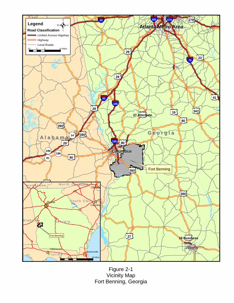
2 Description of the Proposed Action and Alternatives
2.1 Location of the Proposed Action Fort Benning, Georgia (Figure 2-1), occupies approximately 184,000 acres of land, of which
approximately 172,400 acres are located in Georgia and 11,600 acres are located in Alabama. The
Post is located in the lower Piedmont Region of central Georgia and Alabama, predominantly within
Chattahoochee, Muscogee, and Marion Counties in Georgia and partially within Russell County,
Alabama. This project is located in Chattahoochee County.
2.2 Alternatives Development Process NEPA and 32 CFR Part 651 require the consideration of reasonable alternatives to the
Proposed Action. Although a large amount of development exists on Fort Benning, several large
undeveloped areas dedicated to training activities remain throughout the Post. In an attempt to
minimize the impact on existing training activities and future projects, both Fort Benning and AAFES
staff evaluated several feasible sites and site designs against initial concerns and general site selection
criteria to determine the most viable and reasonable alternative locations and site designs. Proposed
sites were identified according to the size of the parcel and the ability to meet the requirements of the
purpose and need.
Site Selection Criteria The following criteria were developed based upon the purpose and need for the Proposed
Action, as well as other land use and environmental factors:
Located near I-185 to be convenient to customers, in an area of heavy traffic flow and high visibility;
Located near a main entrance into Fort Benning;
Consistent with AAFES mission activities;
Atlanta Metro AreaAtlanta Metro Area
ColumbusColumbus
AlbanyAlbany
85
75
185
20 675285
185
431
27
82
80
280
23
29
19 341
231
41
27 Alternate
278
19 Business
80
80
431
280
280
29
29
280
431
29
431
29
21
14
81
199186
G e o r g i aG e o r g i aA l a b a m aA l a b a m a
Fort Benning
Figure 2-1Vicinity Map
Fort Benning, Georgia
G e o r g i aG e o r g i a
F l o r i d aF l o r i d a
A l a b a m aA l a b a m a
S o u t h C a r o l i n aS o u t h C a r o l i n a
N o r t h C a r o l i n aN o r t h C a r o l i n aT e n n e s s e eT e n n e s s e e
AtlantaColumbia
Charlotte
TallahasseeJacksonville
Fort Benning
80 0 8040 Miles
10 0 105 Miles
LegendRoad Classification
Limited Access Higwhay
Highway
Local Roads

2 Description of the Proposed Action and Alternatives
\\Talbdl1\publications\1400-1499\1460.ES06.01_T1474\July05 Final Draft\Final Draft Jul05.doc 2-3
Located near existing commissary and services;
Located near family housing areas;
Minimal environmental constraints;
Provides adequate space for the new uses; and
Has adequate availability of utilities.
Table 2-1
Evaluation of Alternatives Based on Site Evaluation Criteria
Alt. Nea
r I-1
85
Nea
r Mai
n G
ate
Con
sist
ent w
ith
AA
FES
Mis
sion
A
ctiv
ities
Nea
r Exi
stin
g C
omm
issa
ry
Nea
r Fam
ily
Hou
sing
Ade
quat
e Sp
ace
Con
sist
ent w
ith
Mili
tary
Act
iviti
es
Min
imal
En
viro
nmen
tal
Con
stra
ints
Ade
quat
e U
tiliti
es
1 X 2 X X X 3 X X 4 X X X 5 X 6 X X X 7
Key: = Criterion met
X = Criterion not met.
2.3 Alternative Sites Considered, but Eliminated from Further Review Alternatives 1 through 6 were eliminated from further detailed review after preliminary
analysis deemed that each of these alternative sites do not comply with the general siting criteria or
the requirements of the purpose and need. Each of the six eliminated alternative sites are briefly
described below. Alternative 7 (the preferred alternative) meets all of the proposed site evaluation
criteria and will be evaluated along with the no-action alternative (Alternative 8), beginning in
Section 2.4 of this EA.
2.3.1 Alternative 1 This proposed alternative site is bounded by Marne Road to the south, Lindsay Creek
Parkway to the west, Hamlet Creek to the north, and undeveloped forested areas to the north and east
(Figure 2-2). The existing land use is Commercial. The site is directly north of Marne Road from the
existing facility, commissary, and gas station. The nearest family housing is located approximately

2 Description of the Proposed Action and Alternatives
\\Talbdl1\publications\1400-1499\1460.ES06.01_T1474\July05 Final Draft\Final Draft Jul05.doc 2-4
0.75 mile to the southwest, across Lindsay Creek Parkway. The nearest access control point entrance
gate is approximately 2 miles to the north/northwest on Lindsay Creek Parkway.
Alternative 1 meets all but one of the evaluation criteria for the siting of the Proposed Action.
Environmental constraints associated with the implementation of this alternative would be greater
than other alternatives. These include the long-term conversion of 45 acres of undeveloped land to a
shopping mall facility. Furthermore, wetland delineations concluded that 3.44 acres of wetlands exist
on this alternative site, of which 1.80 acres would be impacted, requiring a Section 404 permit from
the USACE. Additionally, a total of 1,171 linear feet of intermittent stream would be impacted by the
Proposed Action under this alternative. In accordance with the Georgia Erosion and Sediment Control
Act, a 25-foot buffer must be between any development and a defined stream channel. Impacts to an
intermittent stream would require a variance, which the State of Georgia is not approving (Fisher
2003). Variances are only allowed for road construction activities that do not impact the flow of the
stream; therefore, because no variances are provided for this type of construction, the project is
considered not possible to construct. Even if variances were granted for this project, the costs of
mitigation would be extensive, totaling approximately $77,000 (Fisher 2003). Furthermore, because
of the grade changes on the site, earth-moving activities would be required bringing in approximately
25,000 cubic yards of fill. Costs associated with these impacts would substantially increase the costs
of the project to AAFES. For these reasons, this alternative was eliminated from further consideration
in subsequent analyses; however, through the alternatives development process, this alternative has
been modified to minimize overall impacts and is presented throughout this EA as Alternative 7
(preferred alternative).
2.3.2 Alternative 2 This proposed alternative site is located on the northeast side of First Division Road, east of
the golf course, and near Outpost Number 2 (Figure 2-2). The site is approximately 82 acres. The
existing and proposed land use for the site is Outdoor Recreation and Open Space. If the Proposed
Action was sited at this location, land use would change to Community Facilities. The site is currently
undeveloped and contains vegetation/trees.
Alternative 2 meets six of the land use and environmental criteria for the siting of the
proposed facility; however, this proposed site is too great a distance from I-185 (approximately 4.1
miles), from the main gate (3.2 miles), and from the existing commissary (1.6 miles). For these
reasons, this alternative was eliminated from further consideration in subsequent analyses.

_̂
_̂
_̂̂_
_̂
_̂
First Division Rd
§̈¦185
£¤27/280
Ivy Rd
M arne Rd
Cusseta Rd
Custer Rd
Up a toi Creek
82nd
Airbo
rne D
ivision
Rd
Dixie Rd
10th D
ivision Rd
Fi rst Division R d
Chattahoochee River
Haml et C ree k
62
70
70
70
70
62
62
62
70
70
62
70
70
70 70
70
62
62
62
62
70
70
7070
62 62
62
70
70
70
70
62
62
2
4
1/75/8
6
3
Figure 2-2Fort Benning Alternative Site Locations and Land Use Map
Fort Benning, Georgia
Streams and RiversInstallation Area Boundary
Land UseAirfieldAdministrationCommunity FacilitiesFamily HousingIndustrialMaintenanceMedicalOpen SpaceOutdoor RecreationSupply StorageTraining/RangesUnaccompanied Housing
Buildings
_̂
_̂
_̂_̂
_̂
_̂
§̈¦185
Firs t Division Rd
Dixie Rd
Ivy Rd
Marne Rd
Marne Rd10th Division Rd
Custer Rd
Cusseta RdBen
ning B
lvdLu
mpkin
Rd
Hamlet Creek
Upatoi Creek
62
62
70
70
2
4
1/7 5/8
6
3
Inset: Alternative Site Locations2,000 0 2,0001,000 Feet
Legend_̂ Alternative Sites
Interstate
2 0 21 Miles
I
Local Road
Highway
Alternative 7 is a revised site design located onthe same proposed location as Alternative 1.
Note:
Noise Contour *
* Noise Zone 1 is less than 62 Noise Zone 2 is from 62 to 70 Noise Zone 3 is greater than 70

2 Description of the Proposed Action and Alternatives
\\Talbdl1\publications\1400-1499\1460.ES06.01_T1474\July05 Final Draft\Final Draft Jul05.doc 2-6
Back of Figure 2-2 (large map)
2 Description of the Proposed Action and Alternatives
\\Talbdl1\publications\1400-1499\1460.ES06.01_T1474\July05 Final Draft\Final Draft Jul05.doc 2-7
2.3.3 Alternative 3 This proposed alternative site is approximately 112 acres located on the north side of First
Division Road and east of Santa Fe Road (Figure 2-2). The existing land use for the site is Open
Space; proposed future land use is Family Housing. If the Proposed Action was sited at this location,
land use would change to Community Facilities. The site is currently undeveloped and contains
vegetation/trees.
Alternative 3 meets seven of the land use and environmental criteria for the siting of the
proposed facility. This proposed site, however, is located approximately 2.7 miles from the main gate
and 0.2 miles from the existing commissary. For these reasons, this alternative was eliminated from
further consideration in subsequent analyses.
2.3.4 Alternative 4 Proposed Alternative 4 is located to the south of Victory Drive, west of I-185, and east of
Santa Fe Road, near Lloyd Elementary School (Figure 2-2). The site is approximately 62 acres. The
existing and proposed future land use for the site is Outdoor Recreation. If the proposed facility was
sited at this location, land use would change to Community Facilities. The site is currently
undeveloped and contains vegetation/trees.
Alternative 4 meets six of the land use and environmental criteria for siting of the proposed
facility; however, the site is located approximately 2.7 miles from the existing commissary. This site
is distant from existing Fort Benning utilities (e.g., sanitary sewer), but could be tied into the City of
Columbus’s utility systems. For this reason, this alternative was eliminated from further consideration
in subsequent analyses.
2.3.5 Alternative 5 Alternative 5 consists of expanding the existing 95,000-square foot PX facility. The PX and
existing commissary complex is located on a site bounded by Marne Road to the north, I-185 to the
west, Hamlet Creek to the north, and undeveloped property to the east and south (Figure 2-2). The
existing facility was built in 1973 and is part of the PX and commissary complex, which includes a
gas station, parking lots, and other services. Additional parking would be added to the east of Hamlet
Creek and would be connected to the proposed facility via a pedestrian bridge. Construction of the
Proposed Action at this alternative site would conform to all applicable building and utility codes,
including the 1997 Unified Building Code (Beachler 2000).
2 Description of the Proposed Action and Alternatives
\\Talbdl1\publications\1400-1499\1460.ES06.01_T1474\July05 Final Draft\Final Draft Jul05.doc 2-8
Alternative 5 meets eight of the nine site-selection criteria. The site proposes some
environmental constraints. In general, the site is flat in disturbed areas, but slopes slightly to the east
and south near the undisturbed areas at the eastern and southern edges of the property. Correction of
these slopes would require the placement of significant amounts of fill. Furthermore, the site would
require the placement of a retaining wall to support the new fill. Contractor estimates indicated that
the design and construction of this retaining wall would cost approximately $8 million dollars. For
these reasons, this alternative was eliminated from further consideration in subsequent analyses.
2.3.6 Alternative 6 The Alternative 6 site is located on the south side of First Division Road (Figure 2-2). This
proposed site is approximately 19.8 acres. The existing land use for the site is Ranges/Training;
proposed land use is the same. The site is currently undeveloped and contains some vegetation/trees.
The site was once a borrow pit, evidenced by the bulk area being devoid of trees.
Alternative 6 meets six of the nine evaluation criteria; however, this site would not provide
adequate space or utilities and location of the facility at this site would not be consistent with military
training activities. Siting at this location would restrict future range requirements and would require
the hardening and possible relocation of the tank trail located south of this site. Safety and noise
concerns would arise because of the proximity of the site to the Pierce and Red Cloud Ranges. For
these reasons, this alternative was eliminated from further consideration in subsequent analyses.
2.4 Actions to be Evaluated Further in the EA
2.4.1 Alternative 7: (Preferred Alternative Site) The preferred alternative site is the same as the Alternative 1 site location (Figure 2-2),
however, due to the environmental constraints presented by Alternative 1, AAFES redesigned the
facility and reduced the footprint of the construction activity to minimize the environmental
constraints, resulting in Alternative 7. The facilities and services that would be provided under
Alternative 7 are as described in Section 1.2 “Description of the Proposed Action.” Alternative 7 is
the only alternative that meets all of the site selection criteria.
This site is currently undeveloped with no known previous development. The site primarily
consists of mature mixed hardwood pine forest and grassland. Prior to construction, the Fort Benning
Land Management Branch will remove all merchantable timber. It is generally flat at the plateau in
the center and slopes out in a radial fashion at the edges of the area to be developed. Two unnamed

2 Description of the Proposed Action and Alternatives
\\Talbdl1\publications\1400-1499\1460.ES06.01_T1474\July05 Final Draft\Final Draft Jul05.doc 2-9
tributaries flow to the north on the eastern and western sides of the central plateau and feed into
Hamlet Creek.
Construction of the Proposed Action at the Alternative 7 site location would last
approximately 20 months. The total disturbed area proposed for the site activities would be
approximately 18.25 acres, including an approximately 218,000-square foot building. A conceptual
site plan for the Proposed Action at the preferred alternative site is shown on Figure 2-3. Construction
of the Proposed Action at the Alternative 7 site would conform to all applicable building and utility
codes, including the 1997 Unified Building Code (Beachler 2000). Since the funding is non-
appropriated, the Spirit design standards, which are Army standard design guidelines would not need
to be followed. However, where appropriate, AAFES will incorporate these design standards into the
construction of the new shopping center.
2.4.2 Alternative 8: The No-Action Alternative (Status Quo) Under Alternative 8, the no-action alternative (status quo), a new shopping facility would not
be built on the Post. The military community that shops at Fort Benning would continue to use the
existing facility that is limited in space and offers an unsatisfactory range of services and
merchandise. Without the construction of a new, modern shopping center, the military community
could increasingly be forced to shop at commercial establishments located off the Post. This would be
both inefficient and inconvenient for active military personnel, their families, and other shoppers
eligible to shop in the PX.

2 Description of the Proposed Action and Alternatives
\\Talbdl1\publications\1400-1499\1460.ES06.01_T1474\July05 Final Draft\Final Draft Jul05.doc 2-10
This page left blank intentionally.

Parking
Building
Parking
The project footprintcovers 18.25 acres
200 0 200100 Feet
Figure 2-3Conceptual Site Plan Ft. Benning, Georgia
I

2 Description of the Proposed Action and Alternatives
\\Talbdl1\publications\1400-1499\1460.ES06.01_T1474\July05 Final Draft\Final Draft Jul05.doc 2-12
This page left blank intentionally.

\\Talbdl1\publications\1400-1499\1460.ES06.01_T1474\July05 Final Draft\Final Draft Jul05.doc 3-1
3 Affected Environment
This section describes the existing natural and human environment on Fort Benning that may
be impacted by the implementation of the Proposed Action or the No-Action Alternative. The
location of the proposed AAFES shopping center under Alternative 7 and the location of Alternative
8 (No-Action Alternative) are within close proximity of each other, basically across the street from
one another (Figure 2-1). Therefore, the affected environment would be the same under
implementation of either of these alternatives.
3.1 Post Location and History Fort Benning is located in the lower Piedmont Region of central Georgia and Alabama,
predominately within Chattahoochee County, Georgia. Portions of the Post are in Muscogee County,
Georgia, with the western segment extending into Russell County, Alabama (Figure 2-1). The Post is
approximately 100 miles south-southwest of Atlanta, Georgia, 6 miles southeast of Columbus,
Georgia, and consists of approximately 182,000 acres of river valley terraces and rolling terrain. The
Chattahoochee River flows through the southern portion of the Post (Figure 2-1).
Fort Benning was established in 1918 to train much-needed infantry troops to fight in Europe
during World War I, and became known as “Home of the Infantry.” The U.S. Army Infantry School
was established at Fort Benning, and has gradually emerged as the most influential infantry center in
the modern world. From 1918 until the present, the development of Fort Benning has been directly
proportional to the progress of the infantry school (Fort Benning 2003a). Fort Benning has three basic
training missions: (1) to conduct Basic Training for new Infantry and non-branch specific recruits,
conduct Infantry, Airborne, and Ranger training for officers and enlisted personnel, and operate a
non-branch-specific Officer Candidate School; (2) to study the doctrine, rationale, equipment, and
future of infantry combat; and (3) to provide a home station and deployment facility for Forces
Command (FORSCOM) and Special Operations Command (SOCOM) units. Fort Benning has carried
out this mission through two World Wars and a number of other military conflicts. Presently, five

3 Affected Environment
\\Talbdl1\publications\1400-1499\1460.ES06.01_T1474\July05 Final Draft\Final Draft Jul05.doc 3-2
types of infantry, including mechanized, light, airborne, air assault, and ranger infantry, train at Fort
Benning (United States Department of the Army [Army] 2001).
3.2 Socioeconomic Resources The Columbus, Georgia Metropolitan Statistical Area (MSA) consists of Muscogee, Harris,
and Chattahoochee Counties in Georgia, as well as Russell County, Alabama, and encompasses a
total of approximately 4,125 square miles.
3.2.1 Demographics As of September 30, 2000, approximately 114,293 total persons were at Fort Benning. This
figure includes on-Post troops, reserves, visitors, and Allied Military personnel and students (31,466),
civilians (7,080), retirees (13,542), dependents of active, retired, and deceased personnel (55,566),
and satellite personnel (6,639; Jackson 2000). Some personnel included in these figures may actually
be assigned and deployed elsewhere in support of Fort Benning. Also, approximately 3,950 families
are housed on-Post, while approximately 6,609 families are housed off-Post (Jackson 2000). Only
authorized personnel and their dependents are allowed to use the services provided by the existing
shopping center facility; these authorized users comprise approximately 4,300 customers daily
(Taylor 2000a).
3.2.2 Economy, Employment, and Income Columbus is Georgia’s third largest city and is the center of commerce for a 26-county trade
area of west-central Georgia and east-central Alabama. Four counties comprise the central MSA for
the City of Columbus include: Muscogee, Harris, and Chattahoochee Counties in Georgia and Russell
County in Alabama. The Columbus MSA contains over 4.5 million square feet of developed retail
space and continues to attract new development, show growth in sales, and a growing customer base.
Fort Benning provides a significant economic impact to the Columbus MSA through military
and civilian payroll and the purchase of goods and services. The existing PX facility has a customer
base that includes: 23,305 active duty personnel with 22,076 dependents; 11,126 retiree sponsors with
18,997 dependents; 4,261 reserve and guard sponsors; and 6,096 dependents, for a total of 85,861
potential customers. Approximately 4,300 customers utilize the existing PX facility on a daily basis,
and facility has 129 employees (90 military; 34 civilian; and five active military; Taylor 2000a).

3 Affected Environment
\\Talbdl1\publications\1400-1499\1460.ES06.01_T1474\July05 Final Draft\Final Draft Jul05.doc 3-3
3.3 Water Resources
3.3.1 Surface Water The Chattahoochee River is the dominant surface water feature at Fort Benning. The
Chattahoochee River, in conjunction with the Flint River to the east, is a major component of the
Apalachicola River drainage basin of eastern Alabama, western Georgia, and the Florida Panhandle.
Numerous oxbows, abandoned meander channels, isolated ponds, and wetland areas are located along
the river. Principal tributaries on the Post that lead to the Chattahoochee include Bull Creek and
Upatoi Creek, each of which has several lesser tributaries flowing into them. The preferred site for the
Proposed Action (Alternative 7) is located between two unnamed tributaries that flow north and
discharge to Hamlet Creek, which is located outside the project limits. Hamlet Creek flows to the
northwest approximately 0.5 miles to Upatoi Creek. Upatoi Creek flows approximately 2.5 miles to
the southwest to the Chattahoochee River.
Water Quality Total maximum daily load (TMDL) is defined as the amount of a particular pollutant that a
water body (stream or water segment, lake, or estuary) can receive and still meet its beneficial use
designation and State water quality standards for that pollutant. TMDLs are developed for all water
bodies identified as not meeting water quality standards and for which there are no ongoing actions to
resolve the impairment.
The State of Georgia has identified 31 stream segments in the Chattahoochee River Basin as
“water quality limited” (i.e., Clean Water Act, Section 303[d] listed) or impaired due to
sedimentation. The “Biota Impacted” designation is given when studies show a modification of the
biological community, primarily due to sediment problems. There are no impaired streams located on
or adjacent to the preferred alternative site.
3.3.2 Groundwater The state of Georgia possesses the largest amount and highest quality groundwater aquifers in
the world. Fort Benning is located in the Coastal Plain hydrogeologic province of Georgia and
Alabama, whose principal groundwater source is the Cretaceous aquifer system. The recharge area for
these aquifers is the Sand Hills area, which includes Fort Benning (Georgia Department of Natural
Resources [GA DNR] 1986).
The Georgia Geologic Survey identifies the Cretaceous aquifers in the Fort Benning area as
the A-3 through A-6 aquifers. The confining strata above and below the aquifers are designated C-3,
C-4, and C-5. Aquifer A-6 is part of the upper Tuscaloosa and the overlying Lower Eutaw
3 Affected Environment
\\Talbdl1\publications\1400-1499\1460.ES06.01_T1474\July05 Final Draft\Final Draft Jul05.doc 3-4
Formations. This aquifer typically yields approximately 50 gallons per minute (gpm) near the Fall
Line, but yields approximately 700 gpm near the southern Post boundary. Water from A-6 is usually
of good quality.
Aquifer A-5 is part of the basal sedimentary sequence of the Blufftown Formation. The A-5
water is more acidic than A-6. Some sedimentary lenses of the A-5 aquifer contain gypsum crystals,
which result in a high sulfate content. Aquifer A-4 is in the upper sedimentary sequence of the
Blufftown Formation, and contains increasing amounts of dissolved solids, sodium, and bicarbonate
concentrations. Both A-4 and A-5 aquifers have low yields and are usually combined with other
aquifers to produce adequate supplies.
The A-3 aquifer correlates with the Cusseta Sand Formation. Yields from this aquifer range
from 1 to 10 gpm in the area surrounding the Post. This aquifer is not considered an individual source
aquifer (Pollard and Vorhis 1980).
The Fort Benning Master Planning Office has mapped aquifer recharge areas to consider
during the planning process for Master Plan projects. The preferred site for the Proposed Action
(Alternative 7) is located within a general recharge area for the Cretaceous aquifer system (Davis et
al. 1988).
3.3.3 Floodplains and Wetlands Executive Order 11988, entitled “Floodplain Management,” requires Federal agencies to take
action to minimize development within floodplains. However, because neither the site of the existing
PX or the preferred alternative site location are within floodplains, this resource will not be addressed
further in this EA.
Gulf Engineers and Consultants completed a mapping overlay of the wetland areas on Fort
Benning. These overlays are available at the Fort Benning Directorate of Public Works (DPW) for
review. This map was generated from data gleaned from National Wetland Inventory (NWI) maps
(also available at DPW for review), United States Department of Agriculture (USDA) Natural
Resources Conservation Service county soil surveys that show soils classified as hydric, color
infrared aerial photographs, and the terrain analysis for Fort Benning.
The AAFES contractor prepared a wetlands jurisdictional delineation for the preferred site
(Alternative 7) of the Proposed Action (Appendix A). Field surveys confirmed that two wetland areas
totaling 0.15 acres are located on the preferred site (see Figure 3-1); however, only 0.114 acres of
jurisdictional waters on the Alternative 7 site would be impacted by development activities related to
the Proposed Action (Figure 3-1). Some of the areas on the preferred site were considered to be
intermittent streams; impacts to these areas are documented by the amount of linear feet impacted.
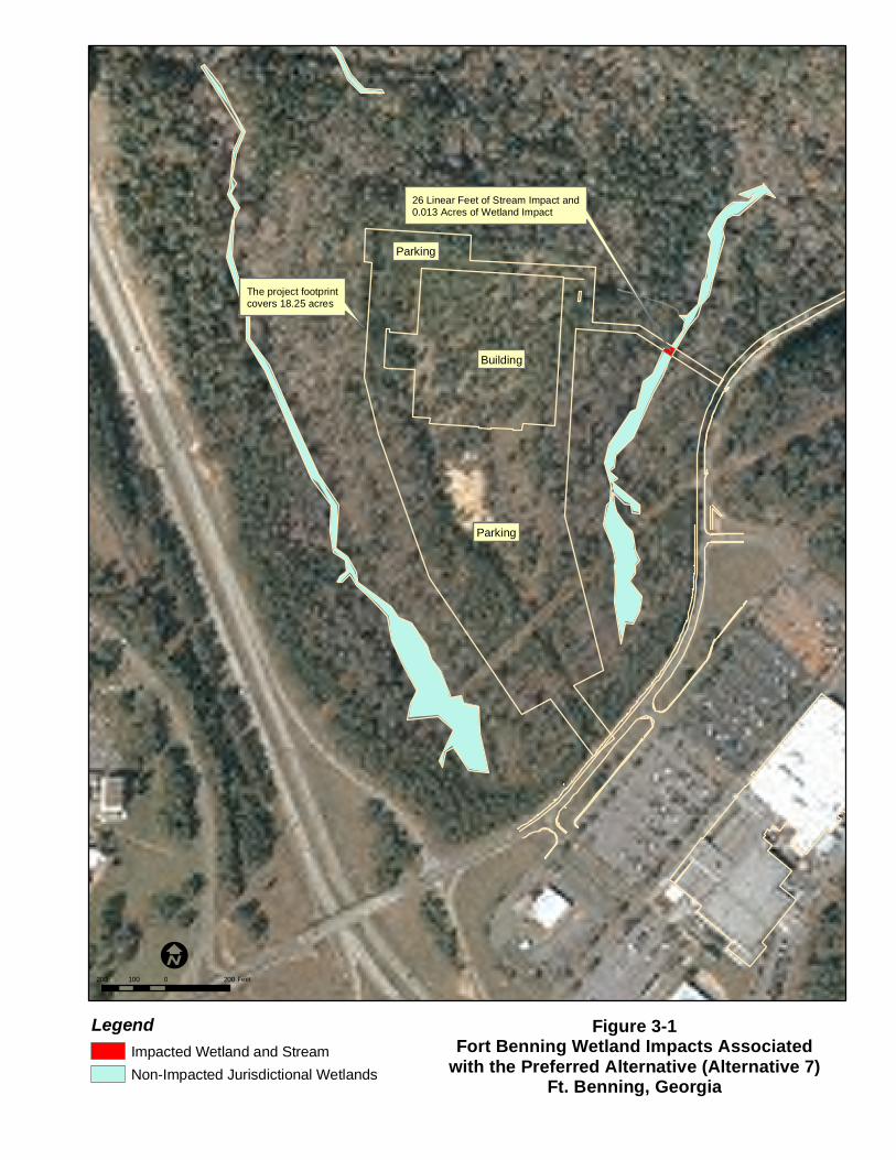
Parking
Building
Parking
26 Linear Feet of Stream Impact and0.013 Acres of Wetland Impact
The project footprintcovers 18.25 acres
200 0 200100 Feet
Figure 3-1Fort Benning Wetland Impacts Associated
with the Preferred Alternative (Alternative 7)Ft. Benning, Georgia
I
LegendImpacted Wetland and StreamNon-Impacted Jurisdictional Wetlands

3 Affected Environment
\\Talbdl1\publications\1400-1499\1460.ES06.01_T1474\July05 Final Draft\Final Draft Jul05.doc 3-6
This page left blank intentionally.
3 Affected Environment
\\Talbdl1\publications\1400-1499\1460.ES06.01_T1474\July05 Final Draft\Final Draft Jul05.doc 3-7
Approximately 26 linear feet would be impacted by the construction of the facility at the
preferred site (Figure 3-1). These areas were delineated using standard survey procedures according
to guidelines outlined in the USACE Wetland Delineation Manual (Environmental Laboratory 1987).
Each area is addressed below (also see Appendix A; Figure 3-1).
Area A. This jurisdictional feature is 0.11 acres in size and is located on the eastern side of the ridge proposed for development. All of Area A would be impacted by the proposed development activities.
Area B. This jurisdictional feature is 0.04 acres in size and is located on the western side of the ridge proposed for development. A total of 0.004 acres of Area B would be impacted by the proposed development activities.
The wetland impacts associated with the implementation of Alternative 7 were substantially
decreased from the original design. The redesign reduced the overall footprint of the facility from 45
acres to approximately 18.25 acres and substantially reduced the size of the parking areas. As a result
of these design modifications, the potential impacts to wetlands areas have been minimized.
3.4 Noise Noise-sensitive receptors of activities related to the implementation of the Proposed Action at
the Alternative 7 site include Martin Army Community Hospital (approximately 890 feet from
construction area), nearby family housing and/or barracks (Northeast Family Housing approximately
305 feet and Southwest Family Housing is approximately 1,190 feet from the construction area),
schools (Faith Middle School), and recreation areas (i.e., athletic complex, swimming pool). Noise
contributors would include vehicular traffic associated with the shopping facility and with I-185 and
Marne Road, helicopter traffic to and from the hospital (approximately 0.4 miles from the preferred
alternative site), sirens from Emergency Medical Service (EMS) units and other emergency response
vehicles, artillery and small arms fire from nearby firing ranges, and flight operations at Lawson
Army Airfield (approximately 4.8 miles from the preferred alternative site). The nearest training
range is the Pierce Range for the TFP Buddy Team, which is approximately 1.3 miles from the
preferred alternative site.
Army Regulation 200-1, Environmental Protection and Enhancement, defines the
requirements for the Army’s Environmental Noise Management Program. Three noise zones (NZ)
are defined in the regulation as indicated below and illustrated in Figure 2-2:
• Zone I (compatible): Housing, schools, medical facilities, and other noise sensitive land uses are compatible with noise levels in the zone (all areas not contained within Zone II or Zone III).

3 Affected Environment
\\Talbdl1\publications\1400-1499\1460.ES06.01_T1474\July05 Final Draft\Final Draft Jul05.doc 3-8
• Zone II (normally incompatible): Noise-sensitive land uses (i.e., housing, schools and medical facilities) are normally incompatible with noise levels in this zone unless measures have been taken to attenuate interior noise levels.
• Zone III (incompatible): Noise-sensitive land uses (i.e., housing, schools, medical facilities) are incompatible in this zone.
3.5 Air Quality
3.5.1 National Ambient Air Quality Standards The Clean Air Act (CAA) of 1970, 42 United States Code (USC) 7401 et seq., amended in
1977 and 1990, is the primary Federal statute governing air pollution. The CAA designates six
pollutants as criteria pollutants, for which National Ambient Air Quality Standards (NAAQS) have
been promulgated to protect public health and welfare. The six criteria pollutants are particulate
matter, (PM10 and PM 2.5), carbon monoxide (CO), sulfur dioxide (SO2), nitrogen dioxide (NO2), lead
(Pb), and ozone (O3). Volatile organic compounds (VOCs) are not considered criteria pollutants, but
emissions of VOCs are linked to ozone concentrations.
In addition, Federal law requires states or local air quality control agencies to establish a State
Implementation Plan (SIP) that prescribes measures to achieve or maintain attainment of these
standards. Areas that do not meet NAAQSs are designated as "non-attainment" for that criteria
pollutant. The GA DNR’s Environmental Protection Division (GA EPD) manages air quality for the
state of Georgia.
The northern portion of Fort Benning is located in Muscogee County and the southern
portion, including the Proposed Action site and each alternative site, is located in Chattahoochee
County. Muscogee County, Georgia, and Russell County, Alabama, were initially designated by the
U.S. EPA as nonattainment for PM2.5 (material primarily formed from chemical reactions in the
atmosphere and through fuel combustion such as motor vehicles, power generation, industrial
facilities, residential fire places, wood stoves and agricultural burning [MOE 2004]) as part of the
Columbus MSA. However, the U.S. EPA published a Supplemental Notice regarding designation in
the Federal Register on April 5, 2005, that revised the Columbus MSA designation to “in attainment”
for PM 2.5 (Gustafson 2005; Veenstra 2005). Therefore, there are currently no additional
requirements on this proposed project due to air attainment status.
3.5.2 Air Emissions Fugitive dust is particulate emissions released from sources that do not have a pinpoint exit
such as a stack or vent. Examples are an uncovered truck bed, or train car, or emissions caused by
vehicles traveling over an unpaved road. A letter from Harold Reheis, GA EPD, April 2003, gives

3 Affected Environment
\\Talbdl1\publications\1400-1499\1460.ES06.01_T1474\July05 Final Draft\Final Draft Jul05.doc 3-9
relief during military training and exercises, but not for other activities such as construction. Fugitive
dust is of concern during the construction phase of the project. The Georgia Rule for Air Quality
(391-3-1.02[2][n]) suggests several ways to mitigate for fugitive dust for activities not related to
military training. Fort Benning’s Title V Permit contains sections on particulate emissions and visible
emissions. The Title V Permit includes Particulate Emissions requirements from GA Rules for Air
Quality 391-3-1.02(2)(e) Particulate Emissions for Manufacturing Processes.
The General Conformity Rule has been promulgated by EPA to ensure that the actions of
Federal departments or agencies conform to the applicable SIP. The General Conformity Rule covers
direct and indirect emissions of criteria pollutants or their precursors that are caused by a Federal
action. Conformity evaluations are not required for areas that are “in attainment” for NAAQS. The
CAA also requires states to implement a Title V permitting program, which is enforced in Georgia by
the GA EPD. Fort Benning was issued a Title V permit effective June 13, 2003 (#9711-215-0021-V-
01-0), that provides limits for various source emissions. This permit contains conditions for several
boilers, test cell operations, fuel tanks, paint booths, and other various emissions sources.
A Risk Management Plan for a worst-case scenario of a chlorine release from Fort Benning’s
water treatment plant indicated the Proposed Action site would be impacted since it is located within,
although on the fringe of, a 1.3-mile impact circle. The water treatment plant is located approximately
1.2 miles west of the Proposed Action site (Gustafson 2000a).
A radon gas survey was not performed at the Alternative 7 site as part of this EA. However,
the EPA Map of Radon Zones and the Environmental Data Resources, Inc. (EDR) Report indicate the
project area is in an area of low potential. Furthermore, in 1993 Fort Benning hired Vail Research and
Technology Corporation to conduct radon monitoring for the Army Radon Reduction Program
(ARRP). Only three of the 2,681 Alpha Track Monitors resulted in readings above 4 picocuries per
liter (pCi/L). Two of the three readings were from “spike detectors.” The third had a reading of 7.3
pCi/L. A memorandum dated March 18, 1993, stated that because only one of the tested Alpha Track
Monitors resulted in a level above the original threshold and that all results were overwhelmingly
below the revised level (of 4 pCi/L), it was recommended that the Fort Benning ARRP be closed with
no further action required. Fort Benning requested that EPA release them from further testing. EPA
never responded, therefore, the Post ceased any further testing (Gustafson 2000b).

3 Affected Environment
\\Talbdl1\publications\1400-1499\1460.ES06.01_T1474\July05 Final Draft\Final Draft Jul05.doc 3-10
3.6 Earth Resources
3.6.1 Geology Fort Benning lies within the Fall Line, which extends approximately from central Alabama to
southern New York and serves as a linear transition zone between the higher Piedmont Physiographic
province to the north and west and lower Coastal Plain physiographic province to the south and east.
The Fall Line Hills are characterized by fairly deep valleys forming a valley, ridge, and plateau
system ranging in altitude from 100 to 200 feet above sea level (ASL). These hills define the rim of
the Chattahoochee basin. The Fall Line Hills elevation within Fort Benning ranges from 190 to 735
feet ASL. Two land-form types make up the Post: low plains and high plains. The low plains are
defined as flat to gently rolling in floodplain areas and gently to moderately rolling elsewhere
(Herrick and Vorhis 1963).
The preferred site of the Proposed Action (Alternative 7) is situated at the juncture of the
Eutaw and Blufftown Formations. The Eutaw Formation predominates in the form of short, steep
outcrops along the streams draining into Upatoi Creek. This Formation consists of a basal course sand
overlain by a dark gray, soft siltstone or shale that is interbedded with fine white sand. Gully erosion
can be severe in this area especially if slopes are modified and vegetation is removed. Conversely, the
Blufftown Formation exists on higher elevations and to the south of the preferred site of the Proposed
Action. This formation consists of alternating beds of sand and sandy clay overlying cross-bedded
coarse sand (USDA 1997). No rock outcrops were observed on the preferred site of the Proposed
Action.
3.6.2 Soils
The Alternative 7 (preferred) site is subdivided into two distinct soil classifications. Soils in
the northern half of the preferred site fall within the general classification of Troup-Cowarts-Nankin
with the predominant soil on site being Nankin Sandy Clay Loam. Soils covering the southern half of
the preferred site are Ruston Sand. The site consists predominantly of Ruston Sand and a small
amount of Ruston Sandy Loam (at the eastern corner of the facility; Fort Benning Land Management
Branch 2000). Ruston series soils consist of very deep, well-drained, moderately permeable soils. On
the preferred alternative site, they are comprised of a surface layer of loose to firm, fine to medium
sand overlaying a loose to very dense, fine to coarse sand. These sand layers are from 10 to 20 feet
deep (Hill-Staton Engineers 1999). Groundwater depth in the area is from 11 to 14 feet below existing
ground surface, as determined by soil borings (Hill-Staton Engineers 1999). Additional soils data can
be obtained from the soil survey (USDA 1997).

3 Affected Environment
\\Talbdl1\publications\1400-1499\1460.ES06.01_T1474\July05 Final Draft\Final Draft Jul05.doc 3-11
3.7 Infrastructure/Utilities This section evaluates the demand and distribution methods for infrastructure and utility
systems on Fort Benning. It should be noted that the Fort Benning water treatment and supply
facilities have been privatized to Columbus Water Works. Under this agreement, Fort Benning retains
ownership of the underlying lands; however, the ownership, operation, and maintenance of the
buildings, systems, and associated water and wastewater facilities is the responsibility of Columbus
Water Works.
3.7.1 Stormwater Drainage Stormwater discharge in the Main Post districts of Fort Benning drain directly into the
Chattahoochee River through a system of drain pipes. Other stormwater drain systems on the Post
include the Harmony Church area, which drains into Mill Creek and Harps Pond; the Sand Hill area,
which drains into Upatoi Creek; and the training compartments, which drain directly or indirectly into
Upatoi Creek, Uchee Creek, and/or the Chattahoochee River. Fort Benning maintains a Stormwater
Pollution Prevention Plan (SWPPP) that establishes best management practices (BMPs) for
controlling and preventing siltation and other contaminants associated with construction and
industrial activity sites from reaching Fort Benning and surrounding area surface waters.
3.7.2 Potable Water As of October 2004, Columbus Water Works is the owner and operator of the water and
wastewater systems at Fort Benning. Fort Benning’s raw water source is Upatoi Creek . The
withdrawal permit associated with the drinking water treatment plant is limited to 12 million gallons
per day (mgd) and an average monthly withdrawal of 10 mgd. Upatoi Creek flow data indicates that
the minimum flow during the dry season is 121 mgd for the month of October. Therefore, it is
determined that Fort Benning’s use totals only approximately 10% of the recorded low flows for
Upatoi Creek.
Raw water is pretreated with chlorine dioxide, alum and lime for coagulation, phosphate, and
fluoride. Fort Benning has the capacity to meet current and projected future water demands. Total
water reserves for the Post are approximately two days (Wilkins 2000). Treated water is distributed
throughout Main Post, Kelley Hill, Sand Hill, Harmony Church, and housing areas via a network of
lines ranging in diameter from 3 to 20 inches.

3 Affected Environment
\\Talbdl1\publications\1400-1499\1460.ES06.01_T1474\July05 Final Draft\Final Draft Jul05.doc 3-12
3.7.3 Wastewater and Water Reclamation As of October 2004, Columbus Water Works owns and operates the two wastewater
treatment plants (WWTPs) that serve the entire Post with a combined capacity of 16 mgd. One
WWTP is a filter sedimentation plant. The second WWTP has an average monthly capacity of 10,000
mgd. Current demand is approximately 7.5 mgd. Demand increases during the summer months to
approximately 8 to 10 mgd. Approximately 95,000 gallons per month of anaerobically digested
sewage sludge is land applied at ten locations on the Post.
Both WWTPs discharge to the Chattahoochee River and operate under one National Pollutant
Discharge Elimination System (NPDES) permit issued by GA DNR. The NPDES permit establishes
wastewater pollutant limits allowed for release to the environment.
3.7.4 Solid Waste Management Fort Benning generates un-compacted solid waste at an estimated rate of 1,200 to 1,500 tons
per month. The Post does not have a permitted sanitary landfill in operation. Currently, all Fort Benning
sanitary waste is transported to a state-permitted facility located off the Post. Three approved inert
landfills are on the Post; however, only one is currently in operation. These landfills are designed to
accept only inert materials, such as fallen limbs and trees, concrete (free of lead-based paint), and cured
asphalt. In addition, several closed landfills are located on the Post; however, none are near the
Proposed Action site or any of the alternative sites.
Recycling reduces disposal cost, conserves natural resources and minimizes environmental
problems associated with land disposal. Fort Benning’s policy on recycling is governed by the June 11,
2003, Policy Memorandum 200-1-8, entitled “Qualified Recycling Program.” Under this policy,
recyclable materials generated by contractors must be turned in to the Post Defense Reutilization
Marketing Office (DRMO) and the Materials Recovery Facility (MRF) for processing.
3.7.5 Transportation Systems Fort Benning is served by several major thoroughfares including I-185 leading from the City
of Columbus, U.S. Highway 27/280, which runs east/west, and Fort Benning Road located west of I-
185. Primary highway access to Fort Benning is via I-185 from the north near its intersection with
Highway 27/280.
A network of primary and secondary roads provides access to and from the Alternative 7 site
via Marne Road from the west, and Dixie Road, 1st Calvary Division Road, and First Division Road
from the south and southwest. Traffic congestion in the area of the Alternative 7 site is minor and
primarily associated with hospital and consumer traffic.
3 Affected Environment
\\Talbdl1\publications\1400-1499\1460.ES06.01_T1474\July05 Final Draft\Final Draft Jul05.doc 3-13
Traffic conditions on Fort Benning have been impacted by the events of September 11, 2001.
For instance, until recently, Fort Benning has been an “open post.” The events of September 11, 2001,
resulted in a high level of security for the Post and access was limited. The number of entry points
into the Post was limited and plans are underway for permanent structures (i.e., traffic islands, fences,
gates, and guard houses at seven existing entry points). Portions of the Post are considered off-limits
and are gated or secured in some manner.
3.7.6 Public and Occupational Health and Safety Police and security services at Fort Benning are provided on a 24-hour basis by both military
police and civilian personnel. Four fire stations serve Fort Benning, including an aircraft and
helicopter crash rescue unit. Emergency services are provided through Martin Army Hospital (Fort
Benning 2003a). A fire reporting communications system is operated by the Fort Benning Fire
Department. An E-911 (enhanced) public emergency reporting system is in place for the Fort
Benning/Columbus area. This system allows emergency responders to immediately locate the origin
of any emergency call received by the control center.
Public safety would also be a concern during the construction of the shopping center.
Appropriate measures would be enacted to limit unauthorized persons from accessing the
construction site. In addition, because construction of the shopping center would require the use of
heavy machinery which involves safety risks to personnel working and/or monitoring these activities,
Occupational Health and Safety Administration (OSHA) requirements and other applicable worker
safety regulations would be followed. For a discussion on environmental justice and protection of
children refer to Section 4.12.
3.7.7 Electrical Systems/Natural Gas Electricity
Georgia Power furnishes electrical services to Fort Benning via a distribution system owned
by Flint Electrical Membership Corporation (Flint EMC), which will be incorporated into the
distribution list of this EA. Transmission lines at the Post have a carrying capacity of approximately
80 megawatts. Peak demand for electrical power usually occurs in July or August and averages about
53 megawatts. Future increases in electrical energy needs are considered to be well within the
capacity of the existing system. In addition, approximately 49 emergency generators exist at the Post.
A transmission corridor owned by Flint EMC also runs northeast/southwest along the
southern portion of the preferred alternative site. The corridor is approximately 20-feet wide and
encompasses approximately 5 acres. Flint EMC owns the distribution system; however, the land is

3 Affected Environment
\\Talbdl1\publications\1400-1499\1460.ES06.01_T1474\July05 Final Draft\Final Draft Jul05.doc 3-14
government-owned. It is not anticipated that the corridor would impact the construction of the
proposed shopping center; however, the corridor may need to be moved to an alternate location.
Relocation of this transmission corridor would be coordinated by Flint EMC and Post personnel.
Natural Gas and Propane Natural gas service is provided by United Cities Gas via a government-owned pipeline
distribution system. Approximately 80 miles of gas distribution lines exist at the Post. Fort Benning is
currently consuming approximately 835,000 hundred cubic feet (hcf) of natural gas per year with
approximately 110,000 hcf of natural gas per year remaining. Propane is used regularly at Fort
Benning with deliveries being made year-round.
Energy Conservation In 1994, the President, by Executive Order 12902 (superceded by Executive Order 13123),
set a fiscal year (FY) 2005 energy reduction goal for DoD installations of 30% and a 35% reduction
goal by FY2010. To establish an objective comparison of energy consumption patterns between
installations, Training and Doctrine Command (TRADOC) adopted the concept of stationary
consumption. One thousand (1,000) British thermal units (MBTU) per thousand feet of building floor
space are the units chosen for consumption of electricity and heating/cooling fuels. The EMC
incorporates conservation components into new construction projects; retrofits older buildings and
residences with energy efficient lighting, heating and insulation; and implements a public awareness
program. The design of new facilities incorporates energy conservation features, such as building
insulation, low-energy lighting, efficient heating and cooling systems, energy-saving water heaters
and appliances, and optimum use of natural ventilation and lighting. Since the TRADOC energy
reduction program began in FY1992, Fort Benning has achieved reductions in energy consumption
equal to 12% below the most recent Executive Order standard for the year 2000 goals (AAFES 2003).
3.8 Hazardous Materials and Wastes The Post maintains a Hazardous Waste Facility Permit (Resource Conservation and Recovery
Act [RCRA] Part B) No. HW-021 (S)-2 and Facility ID No. GA3210020084). The Post also
maintains an Installation Hazardous Waste Management Plan (IHWMP) that establishes the
implementation methods for the permit and identifies seven hazardous waste generating sources on
the Post. Each type of hazardous waste is identified with a plan for collection, storage, and disposal.
Fort Benning operates under a Spill Prevention Control and Countermeasures (SPCC) Plan
for all facilities where hazardous materials are stored. The SPCC Plan delineates measures and
practices that require implementation to prevent and/or minimize spill/release from storage and

3 Affected Environment
\\Talbdl1\publications\1400-1499\1460.ES06.01_T1474\July05 Final Draft\Final Draft Jul05.doc 3-15
handling of hazardous materials to protect ground and waters surfaces. Basic best management
practices (BMPs) for pollution prevention will include monitoring of storage areas, secondary
containment, and loading/unloading areas to ensure that products are not spilled during the
construction, operation, and maintenance of the facility. Implementation of these measures during the
construction, operation, and maintenance of the new AAFES facility would ensure the protection of
soil and water resources.
No recognized environmental conditions were identified for the preferred alternative site
based on a site reconnaissance, telephone interviews, review of historical aerial photographs; and
review of regulatory agency database listings. In addition, there are no records of contamination being
found in samples from a groundwater monitoring well previously installed at the Alternative 7 site.
No hazardous materials are used, nor generated, at the preferred site.
3.9 Biological Resources This chapter describes the existing biological features at Fort Benning and provides a
description of biological resources on the preferred alternative site. The following discussion is based
on a review of available literature, information provided by environmental personnel at Fort Benning.
In addition, information on threatened and endangered flora and fauna was received from the GA
DNR Natural Heritage Program (NHP).
3.9.1 Vegetation Fort Benning is included within the broad, oak-hickory-pine forest area of the southeastern
United States. Changes in agriculture and forestry practices and land ownership over the past 150
years have contributed significantly to a change to a predominantly coniferous or
coniferous/deciduous mixture. Fort Benning vegetation consists of approximately 16,000 acres of
maintained lawn and grassed areas; 3,000 acres of open land and old fields (shrubs and herbaceous
plants); and, approximately 161,000 acres of woodland. Loblolly (Pinus taeda) and longleaf pine
(Pinus palustris) are the principal conifers on the reservation and comprise approximately 64,000
acres of woodlands. The remaining 97,000 acres of woodland are comprised of approximately 21,000
acres of mixed pine and hardwoods and 76,000 acres of hardwood forest.
A limited survey of habitats present on the preferred alternative site performed by an AAFES
consultant concluded that the site is predominated by two vegetation communities. These
communities include hardwood forest on the hillsides adjacent the intermittent streams and
approximately 34 acres of pine and mixed pine stands greater than 30 years old near the central
plateau.
3 Affected Environment
\\Talbdl1\publications\1400-1499\1460.ES06.01_T1474\July05 Final Draft\Final Draft Jul05.doc 3-16
The stand of widely spaced short-leaf pine (Pinus echinata) and loblolly pine that dominates
the central plateau has an herbaceous understory maintained through the use of controlled burning.
Common species observed in this community include bluestem (Andropogon virginica), barnyard
grass (Paspalum spp.), panic grasses (Panic sp.), goldenrod (Solidago sp.), asters (Astor sp.), daisy
fleabane (Erigeron sp.), lespedeza (Lespedeza sp.), and dewberry (Rubus sp.).
The slopes descending from the plateau to the intermittent streams are primarily middle-aged
mesic oak-hickory forest. Common overstory species growing in this community include southern red
oak (Quercus falcata), red oak (Q. rubra), white oak (Q. alba), water oak (Q. nigra), hickory (Carya
sp.), flowering dogwood (Cornus florida), sugar maple (Acer saccharum), sourwood (Oxydendrum
arboreum), and sweetgum (Liquidambar styraciflua). Minor components of the overstory are loblolly
pine, blackcherry (Prunus serotina), American beech (Fagus grandifola), and near the summit, post
oak (Q. stellata). Understory species observed were blueberry (Vaccinium sp.), greenbrier (Smilax
rotundifolia), muscadine (Vitus rotundifolia), and scattered grasses (Chasmanthium sp.).
3.9.2 Wildlife Fort Benning is inhabited by approximately 345 species of wildlife (Fort Benning 2004).
These species include 152 species of birds, 47 species of mammals, 47 species of reptiles, 24 species
of amphibians, 67 species of fish, and 8 species of mussels (shellfish; Fort Benning 2001).
State and/or Federal laws protect many species of wildlife. Harvest of game species, such as
white-tailed deer (Odocoileus virginianus), wild turkey (Meleagris gallopavo), bobwhite quail
(Colinus virginianus), rabbits (Sylvilagus sp), catfish (Ictalurus sp.), and largemouth bass
(Micropterus salmoides), is regulated by Post personnel, GA DNR, and the Alabama Department of
Conservation and Natural Resources . Federal and state laws are addressed in United States Army
Infantry Center (USAIC) Circular 200-3-1 “Hunting Seasons and Bag Limits” and USAIC Regulation
200-3-2 “Hunting and Fishing Regulation.” Specific requirements for protection of some species of
wildlife on Fort Benning (such as the red-cockaded woodpecker [RCW] and gopher tortoise) are
contained in USAIC Regulation 210-4 “Range and Terrain Regulation.”
The Alternative 7 (preferred) site provides cover and forage habitat to support various species
of mammals, birds, reptiles, and amphibians common to Chattahoochee and adjacent counties. Due to
the lack of permanent streams or other waterbodies on site, fish and mussels are not likely to inhabit
the site. Common mammals that likely utilize the site are white-tailed deer, Eastern grey squirrel
(Sciurus carolinensis), Eastern cottontail (Sylvilagus floridanus), bobcat (Lynx rufus), raccoon
(Procyon lotor), opossum (Didelphis virginiana), and coyote (Canis latrans).
3 Affected Environment
\\Talbdl1\publications\1400-1499\1460.ES06.01_T1474\July05 Final Draft\Final Draft Jul05.doc 3-17
Bird species likely to inhabit or utilize the preferred site are American crow (Corvus
brachyrhynchos), blue jay (Cyanocitta cristata), Carolina chickadee (Parus carolinensis), dark-eyed
junco (Junco hyemalis), northern cardinal (Cardinalis cardinalis), northern flicker (Colaptes
auratus), northern mockingbird (Mimus polyglottos), red-shouldered hawk (Buteo lineatus),
woodpeckers (Picoides spp.), sparrows, and warblers. Game birds either observed directly or
indirectly on site during November 2000 were mourning dove (Zenaida macroura) and Eastern wild
turkey (Meleagris gallopavo).
Reptiles and amphibians likely to inhabit the site include the eastern garter snake
(Thamnophis sirtalis), rat snakes (Elaphe obsoleta), eastern box turtle (Terrapene carolina), green
anole (Anolis carolinensis), skinks (Eumeces spp.), and toads (Bufo spp.).
3.9.3 Threatened and Endangered Species Ninety-six (96) species (four amphibians, eight birds, seven fishes, four mammals, four
mussels, nine reptiles, and 60 plants) of conservation concern are located on Fort Benning. Army
installations must be sensitive to those species that are listed as endangered or threatened under State
law, but that are not federally listed (AR 200-3). State-listed species are not protected under the
Endangered Species Act (ESA); however, whenever feasible, the Post cooperates with State
authorities in an effort to identify and conserve state-listed species.
Five federally listed, threatened, and endangered species occur on Fort Benning. These
include the red-cockaded woodpecker (E), wood stork (E), bald eagle (T), American alligator (T
[S/A], in which S/A = due to similar appearance), and relict trillium (E). The red-cockaded
woodpecker (RCW) is the only federally protected species known to occur within the vicinity of the
preferred alternative site. On March 17, 2005, in response to a letter received from the United States
Fish and Wildlife Service (USFWS), Fort Benning Conservation Branch personnel surveyed the
proposed site of the new shopping center for the presence of the federally endangered relict trillium.
All areas that were determined to be suitable habitat were surveyed and no relict trilliums were
observed.
Red-Cockaded Woodpecker The RCW (Picoides borealis) was placed on the Federal list of endangered species in 1970.
The reasons for its protected status included species rarity, documented declines in local populations
and reductions in available nesting habitat. Although populations have become more fragmented and
isolated, the RCW is rather widely distributed. The species is still found in all Southern and
Southeastern Coastal States from eastern Texas into southern Virginia, and small interior populations
are found in southeastern Oklahoma and southern Arkansas, and until recently, southeastern

3 Affected Environment
\\Talbdl1\publications\1400-1499\1460.ES06.01_T1474\July05 Final Draft\Final Draft Jul05.doc 3-18
Kentucky. The largest populations are in the Coastal Plain forests of the Carolinas, Florida, Georgia,
Alabama, Mississippi, Louisiana, eastern Texas, and in the Sandhills forests of the Carolinas
(USFWS Biological Opinion 1999).
Fort Benning has one of the largest RCW populations in the southeastern United States. The
RCWs are well dispersed over the entire Post, except that no active clusters are located on the
Alabama portion of the Post. On September 27, 2002, the USFWS approved Fort Benning’s
Endangered Species Management Plan (ESMP) for the RCW and issued a Biological Opinion (BO) that
included specific management activities. This allowed the implementation of the “1996 Management
Guidelines” for the RCW on Army installations. Fort Benning is also one of 13 primary core locations
selected by the USFWS to manage for a RCW recovery population (451 clusters for Fort Benning).
Presently, Fort Benning has a total of 311 manageable RCW clusters (251 active and 60 inactive, as
of 2003). There is an additional estimate of 43 active clusters and one inactive cluster in ordnance
impact areas A20 and K15.
The Alternative 7 site is potential foraging habitat for the federally endangered RCW.
Fourteen (14) RCW trees associated with abandoned cluster AA-01 are present on the site; this site
has been inactive for more than 10 years and was deleted from management in 1998 (Brent 2000).
The area is not foraging habitat for any currently active clusters and is not in the foraging circle for
any inactive clusters (the normal foraging range for RCW is 0.5 mile (Barron 2005). The nearest
active cluster is approximately 1.5 miles southeast of the preferred site and the nearest inactive cluster
is approximately 1 mile to the southwest. The nearest planned recruitment site is located
approximately 1 mile southeast of the Alternative 7 site.
3.10 Cultural Resources Historic properties are protected by a variety of laws and regulations, including the National
Historic Preservation Act (NHPA), the Archaeological Resources Protection Act (ARPA), the
American Indian Religious Freedom Act (AIRFA), and the Native American Graves Protection and
Repatriation Act (NAGPRA).
Section 106 of the NHPA and implementing regulations (36 CFR 800) outline the procedures
to be followed in the documentation, evaluation, and mitigation of impacts for historic properties. The
Section 106 process applies to any Federal undertaking that has the potential to affect historic
properties. Projects that require Federal funding or are subject to Federal regulation also are subject to
the Section 106 process, and ensuring compliance with the process is the responsibility of the relevant
Federal agency. Due to time and resource constraints, project proponents usually fund and contract

3 Affected Environment
\\Talbdl1\publications\1400-1499\1460.ES06.01_T1474\July05 Final Draft\Final Draft Jul05.doc 3-19
for the actual work to be done, and the Federal agencies do the formal consulting required by the
regulations.
The GA DNR Historic Preservation Division (GA HPD) and sometimes the Advisory
Council on Historic Preservation (ACHP) must be consulted regarding impacts to cultural resources
and means to mitigate the impact. Once resources have been identified, and impacts defined,
mitigation measures are determined. Depending on the resources encountered, federally recognized
American Indian Tribes, with whom Fort Benning confers, may also be consulted.
The area of potential effect (APE) is the geographical area or areas within which an
undertaking may cause changes to the character or use of historic properties. Under Alternative 7 (the
preferred alternative), the preliminary APE has been defined by AAFES as an approximate 22-acre
parcel located north of the existing PX facility on Fort Benning.
The purpose of this assessment is to identify whether known archaeological sites and historic
structures are within the APEs, and to assess the potential for unidentified cultural resources to exist
in the APEs. The assessment included a site visit to confirm expectations with regard to
environmental and cultural settings, review of archaeological survey reports completed for the area,
and consultation with Dr. Chris Hamilton, Fort Benning Archaeologist, regarding known resources on
the Post. Coordination with the State Historic Preservation Officer (SHPO) has been completed. The
SHPO concurred that the preferred alternative would not affect any resources eligible for listing on
the National Register of Historic Places (NRHP; see Appendix B).
3.11 Land Use Fort Benning is the site of training, administrative, and residential activities, as well as
associated land management activities. Fort Benning’s Land Use Plan establishes both current and
future land use activities on the Post. Fort Benning is divided into five land management units
(LMUs): Main Post, Sand Hill, Kelly Hill, Harmony Church, and housing areas. These five LMUs are
divided into 31 training areas. These training areas are further subdivided into training compartments,
ranges, impact zones, drop zones, exclusion areas, cantonment areas, and recreation areas. Combined,
the cantonment and family housing areas occupy approximately 8% of the Post. A 1,095-acre
recreation area is also located along Uchee Creek on the western bank of the Chattahoochee River.
Main Post, adjacent to South Columbus, is the largest and most developed of the cantonment
areas, containing the Installation Headquarters, the Infantry School, and the barracks complex known
as the Cuartels. Main Post includes Lawson Army Airfield, Martin Army Community Hospital, the
Post Exchange, the commissary and various family housing areas. Sand Hill contains barracks, dining
facilities, classrooms, and other facilities for training. Kelley Hill, contains barracks and support
3 Affected Environment
\\Talbdl1\publications\1400-1499\1460.ES06.01_T1474\July05 Final Draft\Final Draft Jul05.doc 3-20
facilities. Harmony Church contains semi-permanent barracks and support structures. An active
program is underway to eliminate some of these structures for the reuse of formerly occupied areas
for land reclamation (forestry) and other uses, such as Major Construction, Army (MCA) and other
projects (AAFES 2003).
Field training activities occur on about 104,000 acres of the Post. Activities include the
movement of personnel through wooded and open areas on foot, movement of wheeled vehicles on
dirt and gravel roads, and the establishment of bivouac sites. Activities conducted by the mechanized
infantry and tank units at Fort Benning are limited by the amount of suitable terrain to support
movement of heavy vehicles. Armor, artillery, and mortar firing occurs from established firing points
at three major range areas on the Post: the Alpha Range Complex, Malone Range Complex, and
Oscar-Kilo Range Complex. Fire is directed toward controlled-impact areas covering approximately
59,000 acres. Other weapons fired at the ranges include miscellaneous rifles, pistols, anti-armor, and
automatic weapons, as well as special training devices that electronically simulate the firing of
weapons systems at targets. Other activities related to military training include training in the
operation and maintenance of vehicles, academic military training, and physical training.

\\Talbdl1\publications\1400-1499\1460.ES06.01_T1474\July05 Final Draft\Final Draft Jul05.doc 4-1
4 Environmental Consequences
4.1 Introduction This chapter presents an analysis of the potential environmental consequences of each
alternative on potentially affected media. The analysis is separated into effects resulting from the
construction of the shopping center at the preferred site (Alternative 7), as well as the analysis of the
No Action Alternative/Status Quo (Alternative 8). Threshold levels of significance criteria are used to
evaluate potential impacts, which are discussed at the beginning of each resource area.
4.2 Socioeconomic Resources The threshold level of significance for socioeconomic resources is the potential for the project
to result in a substantial population increase, displace residents, or result in a substantial change in
employment or income.
4.2.1 Alternative 7: Preferred Alternative Site Demographics
Under Alternative 7, demographic compositions are expected to remain the same. Although
the customer base would likely increase by approximately 2,000 persons at the new shopping center,
these increases would likely result in no compositional changes of gender, age, or race (Taylor
2000a). Therefore, implementation of Alternative 7 would result in no effect to demographics. No
mitigation measures are proposed.
Economy, Employment, and Income The construction of the proposed shopping facility at Fort Benning would result in a slight
positive effect to the economy, employment, and income for the Post and income for the surrounding
areas. The proposed facility would employ approximately 190 people: 80% military dependent; 15%
civilian; and, 5% active military. Because of the convenience of the Alternative 7 site location
4 Environmental Consequences
\\Talbdl1\publications\1400-1499\1460.ES06.01_T1474\July05 Final Draft\Final Draft Jul05.doc 4-2
combined with the sale of tax-free goods, the customer base is expected to increase by approximately
2,000 customers per day (Taylor 2000a). Since most competing grocery and department stores are
located approximately 6 to 7 miles away in the northern portion of Columbus, no effect would be
expected on the local economy (Carveza 2000). No mitigation measures are proposed.
4.2.2 Alternative 8: No-Action Alternative The no-action alternative would have no effect on demographic compositions; however, the
economic activity and incomes at Fort Benning would result in potential moderate adverse impacts.
The existing PX facility is highly congested and too small to adequately service the customer base;
upgrades are needed to food concepts, mechanical equipment, and parking facilities. Fort Benning
would likely be unable to meet future demands and, therefore, customers would likely shop elsewhere
resulting in a loss of revenue for AAFES and Fort Benning, thereby, potentially resulting in the
closure of the PX facility and the loss of jobs for those employed at the existing PX facility. No
mitigation measures are proposed for this alternative.
4.3 Water Resources The threshold level of significance for water resources is the potential of the project to cause
substantial changes in wetlands functions, groundwater or surface water flows, increased risk of
flooding, the potential to violate an applicable water quality standard for protection of fish and
wildlife, or degradation of a water body used as a potable water source.
4.3.1 Alternative 7: Preferred Alternative Site Surface Water
Construction of the Proposed Action at the preferred alternative site would result in the loss
of natural vegetation and trees on approximately 18.25 acres. Because of the vegetation loss during
construction activities, highly erodible soils located at the Alternative 7 site would be exposed and the
potential for soil erosion and sedimentation to the unnamed tributaries and Hamlet Creek would
increase resulting in minor adverse impacts. During construction activities, the contractor would be
required to implement strict erosion-control measures to prevent increased erosion and sedimentation
during construction in accordance with the Georgia general permit (GAR 100001). The provisions of
the general stormwater permit require the following: 1) submission of a Notice of Intent (NOI) to GA
EPD; 2) development of an Erosion, Sedimentation, and Pollution Control (ES&PC) Plan that
describes BMPs to be implemented at a site (vegetative and structural); 3) implementation of a
comprehensive monitoring program (CMP), which includes rainfall and stormwater discharge

4 Environmental Consequences
\\Talbdl1\publications\1400-1499\1460.ES06.01_T1474\July05 Final Draft\Final Draft Jul05.doc 4-3
turbidity monitoring. The ES&PC Plan and CMP must be submitted to GA EPD, as well as the
turbidity monitoring reports and a Notice of Termination (NOT) when construction is completed.
All on-site activities would be accomplished in accordance with the SWPPP. Implementation
of the Proposed Action at the Alternative 7 site would include measures similar to existing
stormwater BMPs at the PX and measures recommended in the SWPPP and would include BMPs to
control erosion from entering nearby creeks and waterways. Surface drainage from all paved and
landscaped areas would be routed to two separate detention areas that would mitigate storm
surcharges and would aid in removing non-point source pollutants generated from stormwater runoff
at the site. Project design would also include BMPs for control of surface drainage that could contain
hazardous materials, such as oil and grease in accordance with the IHWMP.
The contractor and AAFES would also be required to prepare and implement an SPCC Plan
during the construction, operation, and maintenance of the facility. The SPCC Plan would delineate
measures and practices that would be implemented to prevent and/or minimize spill/release from
hazardous materials into water surfaces. Basic BMPs for pollution prevention would include
monitoring of storage areas exposed to the elements to ensure that pollutants are not discharged into
storm drains during the construction, operation, and maintenance of the facility. These measures
would ensure the protection of water resources. Additionally, under the new Municipal Separate
Storm Sewer System (MS4) requirements, the same BMPs would address water pollution from
storage areas. All facilities within the food court would meet requirements to ensure that any
aboveground storage tanks for oil/grease management are properly managed and that they do not
discharge directly into the storm drains. MS4 requirements would address possible sewage overflows
and backups that could reach waterways. Measures would also need to be implemented to ensure that
these products would not interfere with the sanitary sewer disposal to be established under the
Columbus Water Works system. Adherence to the above-mentioned plans and regulations would limit
potential adverse effects to surface water to minor adverse effects. No additional mitigation measures
are proposed.
Groundwater Construction of the Proposed Action at the Alternative 7 (preferred) site would be within an
aquifer recharge area. All onsite construction and operation activities would be required to be in
accordance with the Fort Benning SWPPP. Hazardous materials would be stored and disposed of in
accordance with all local, state, and Federal laws and regulations, and the IHWMP; SPCC Plan; and
Installation Spill Contingency Plan (ISCP). Surface drainage from all paved and landscaped areas
would be routed to two separate detention areas that would mitigate storm surcharges and would aid
in removing non-point source pollutants generated from stormwater runoff at the site. Project design
4 Environmental Consequences
\\Talbdl1\publications\1400-1499\1460.ES06.01_T1474\July05 Final Draft\Final Draft Jul05.doc 4-4
would also include BMPs for control of surface drainage that could contain hazardous materials, such
as oil and grease in accordance with the IHWMP. Because of adherence to existing plans and
regulations, no adverse effects to groundwater resources would be expected. No mitigation measures
are proposed.
Wetlands The implementation of the Proposed Action at the Alternative 7 site would result in adverse
effects to approximately 0.114 acres of wetlands and 26 linear feet of intermittent stream permanently
converting these areas to improved land (shopping center footprint). These streams are considered to
be waters of the United States and are protected by the State of Georgia in accordance with the
Georgia Erosion and Sediment Control Act. According to the Georgia Department of Environmental
Protection, road crossings and drainage structures are exempt from stream buffer protection
requirements (Chambers 2004). Therefore, this project would not require a stream buffer variance
(Chambers 2004).
Ecology & Environment, Inc. provided a wetlands delineation report to the USACE for
review and approval. Based on the findings of this report, the USACE granted the use of Nationwide
Permit #18 (Appendix C) and does not require an individual Section 404 permit. There would be no
change in wetlands function due to this alternative.
The use of this permit is allowed if and only if AAFES adheres to the following permit
conditions:
The activity is conducted in accordance with the information provided and meets the conditions applicable to the Nationwide Permit as described in Part C of the excerpt of the 67 CFR and the attached copy of the Savannah District Nationwide Permit Regional Conditions.
AAFES obtain a stream buffer variance, if required.
The attached permit sheet is signed and returned 30 days prior to completion of the activity authorized by this permit.
Although the wetlands are being permanently impacted, because of the small amount and the
ability to utilize the Nationwide Permit, these impacts would be considered minor adverse impacts.
No additional mitigation measures are proposed under this alternative.
4.3.2 Alternative 8: No-Action Alternative Implementation of the no-action alternative would require no new construction activities on
the Post. Because there would be no construction activities, there would be no effect to surface
waters, groundwater, wetlands or floodplains. However, the maintenance and operation of the

4 Environmental Consequences
\\Talbdl1\publications\1400-1499\1460.ES06.01_T1474\July05 Final Draft\Final Draft Jul05.doc 4-5
existing PX facility would continue to be performed in accordance with the Fort Benning SWPPP.
Hazardous materials would be stored and disposed of in accordance with all local, state, and Federal
laws and regulations, and the IHWMP; SPCC Plan; and ISCP. In addition, under a new assessment in
accordance with Columbus Water Works and future MS4 requirements, the implementation of new
BMPs would provide additional protection against pollutants entering into sewer lines (sanitary and
storm water) and degrading will improve water quality. No additional mitigation measures are
proposed for this alternative.
4.4 Noise The threshold level of significance for noise is the increase of Zone III (incompatible) noise
contours where sensitive noise receptors (i.e., residences, hospitals, libraries) are located.
4.4.1 Alternative 7: Preferred Alternative Site Construction
Under Alternative 7, ambient noise levels at and around the construction site would
temporarily increase during construction. The preferred alternative site would be located in Zone 1,
where noise sensitive receptors (i.e., housing, schools, and medical facilities) are compatible with the
noise environment (Figure 2-2; US Army 1997). Standard construction equipment would be used,
including log chippers and shredders, bulldozers, front end loaders, pans track hoes, backhoes,
graders, dump trucks, vibrating compactors, sheepsfoot compactors, trenchers, cranes, equipment
repair truck, ready-mix trucks, concrete pumping trucks, curb and gutter machines, pavers, forklifts,
and building material and equipment delivery trucks. Based on data presented in the U.S. EPA
publication, Noise from Construction Equipment and Operations, Building Equipment, and Home
Appliances (U.S. EPA 1971), outdoor construction noise levels range from 78 dBA to 89 dBA,
approximately 50 feet from a typical construction site. However, as indicated previously, the sensitive
receptors are all located a distance greater than 50 feet from the preferred alternative site; therefore,
there would be no increase of Zone III noise contours into areas containing sensitive noise receptors.
Table 4-1 presents typical noise levels (dBA at 50 feet) estimated by U.S. EPA for the main phases of
construction.
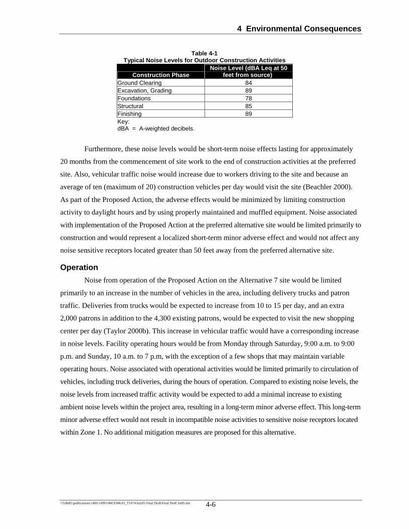
4 Environmental Consequences
\\Talbdl1\publications\1400-1499\1460.ES06.01_T1474\July05 Final Draft\Final Draft Jul05.doc 4-6
Table 4-1 Typical Noise Levels for Outdoor Construction Activities
Construction Phase Noise Level (dBA Leq at 50
feet from source)) Ground Clearing 84 Excavation, Grading 89 Foundations 78 Structural 85 Finishing 89 Key: dBA = A-weighted decibels.
Furthermore, these noise levels would be short-term noise effects lasting for approximately
20 months from the commencement of site work to the end of construction activities at the preferred
site. Also, vehicular traffic noise would increase due to workers driving to the site and because an
average of ten (maximum of 20) construction vehicles per day would visit the site (Beachler 2000).
As part of the Proposed Action, the adverse effects would be minimized by limiting construction
activity to daylight hours and by using properly maintained and muffled equipment. Noise associated
with implementation of the Proposed Action at the preferred alternative site would be limited primarily to
construction and would represent a localized short-term minor adverse effect and would not affect any
noise sensitive receptors located greater than 50 feet away from the preferred alternative site.
Operation Noise from operation of the Proposed Action on the Alternative 7 site would be limited
primarily to an increase in the number of vehicles in the area, including delivery trucks and patron
traffic. Deliveries from trucks would be expected to increase from 10 to 15 per day, and an extra
2,000 patrons in addition to the 4,300 existing patrons, would be expected to visit the new shopping
center per day (Taylor 2000b). This increase in vehicular traffic would have a corresponding increase
in noise levels. Facility operating hours would be from Monday through Saturday, 9:00 a.m. to 9:00
p.m. and Sunday, 10 a.m. to 7 p.m, with the exception of a few shops that may maintain variable
operating hours. Noise associated with operational activities would be limited primarily to circulation of
vehicles, including truck deliveries, during the hours of operation. Compared to existing noise levels, the
noise levels from increased traffic activity would be expected to add a minimal increase to existing
ambient noise levels within the project area, resulting in a long-term minor adverse effect. This long-term
minor adverse effect would not result in incompatible noise activities to sensitive noise receptors located
within Zone 1. No additional mitigation measures are proposed for this alternative.

4 Environmental Consequences
\\Talbdl1\publications\1400-1499\1460.ES06.01_T1474\July05 Final Draft\Final Draft Jul05.doc 4-7
4.4.2 Alternative 8: No-Action Alternative Under the no-action alternative, existing noise levels would remain the same. Because the
status quo would be maintained, adverse effects to sensitive receptors at Fort Benning would not
occur. No mitigation measures are proposed for this alternative.
4.5 Air Quality The threshold level of significance for air quality for this project has been set at the same
threshold used for new stationary sources for the Prevention of Significant Deterioration (PSD) of air
quality within a region. While this threshold is used for stationary sources, it provides a reasonable
measure of the impact of a Proposed Action for air quality evaluation purposes. The sources of
emissions related to this project are mobile sources, and stationary source emissions, which are not
likely to change as a result of this action.
4.5.1 Alternative 7: Preferred Alternative Site Long-term effects to the immediate project area would occur from emissions due to an
increase in deliveries and customer vehicular traffic. However, because the expanded facility would
be located on Fort Benning, it is anticipated that it would attract more customers and reduce the
number of trips to Columbus. Therefore, total vehicle emissions for the Columbus area would likely
remain the same as a result of the Proposed Action. The preferred alternative site is contained within
the footprint of the chlorine gas release worst-case scenario; however, the site is located on the fringe
of a 1.3-mile impact circle. No long-term effects would result from implementing the Proposed
Action on the Alternative 7 site.
However, the operation of heavy equipment would have minor, temporary negative effects on
air quality during the construction phase. These negative effects would be primarily in the form of
increased exhaust pollutants that would be minimized through good vehicle maintenance. Windblown
soil and dust could also occur during the construction phase as a result of equipment movement over
exposed soil areas. Fugitive dust would be greatly minimized by implementing appropriate dust
control measures, such as wetting the surfaces and by re-vegetating disturbed areas as soon as
possible. Therefore, the primary short-term air quality impacts resulting from the Proposed Action
would be a temporary increase of air pollutants during construction, which would cease upon
completion of the project.
Construction would take approximately 20 months to complete, although 12 months of
construction is evaluated to estimate annual emissions. Following the removal of marketable timber,

4 Environmental Consequences
\\Talbdl1\publications\1400-1499\1460.ES06.01_T1474\July05 Final Draft\Final Draft Jul05.doc 4-8
remaining slash and vegetation debris would be removed via trucks and other heavy equipment prior
to construction; no burning would take place under this alternative. The construction activities
considered in this evaluation include the operation of construction equipment and vehicles, site
preparation (for particulate emissions), and paving operations (for VOC emissions). The number and
type of equipment would vary depending upon the amount and type of work being completed at the
Alternative 7 site. The operation of construction equipment has been generalized, assuming that at
any given time, one of each type of equipment would be operating, 5 days a week, 8 hours a day.
Total estimated annual construction emissions for implementing the Proposed Action at the preferred
alternative site are listed below in Table 4-2. The construction equipment, activities, emission factors
and calculations are detailed in Appendix D.
Table 4-2
Total Projected Annual Emissions from Construction Activities Fort Benning PX: Alternative 7 (Preferred Alternative)
Emissions (pounds/year) Activity NOx VOC CO SO2 PM10
a Equipment Operation 45.59 4.84 30.11 0.00 2.41 Demolition 0.00 0.00 0.00 0.00 0.00 Site preparation 0.00 0.00 0.00 0.00 1.54 Paving 0.00 0.19 0.00 0.00 0.00 TOTAL 45.59 5.03 30.11 0.00 3.95
Note: a Approximately 90% of total PM10 emissions would be PM2.5 (Gustafson 2005). Key: CO = Carbon monoxide. NOx = Nitrogen oxides. PM10 = Particulate matter (10 microns or less). SO2 = Sulfur dioxide. VOC = Volatile organic compound.
Since emissions of all criteria pollutants are below the 100 and 250-tpy thresholds, this action
would not be considered a major source. In addition, VOCs and NOX are below the de minimis
standards established by the Conformity Rule, and therefore these emissions would not impact ozone
concentrations in the area. No additional mitigation measures are proposed for this alternative.
4.5.2 Alternative 8: No-Action Alternative Implementation of the No-Action Alternative would result in no new construction activities.
However, the existing PX/commissary facility would continue to operate and would result in the same
amount of air effects that currently exist. Therefore, there would be no change in existing conditions.
No mitigation measures are proposed for this alternative.

4 Environmental Consequences
\\Talbdl1\publications\1400-1499\1460.ES06.01_T1474\July05 Final Draft\Final Draft Jul05.doc 4-9
4.6 Earth Resources The threshold level for earth resources (i.e., soils and topography, and geology) is any ground
disturbance or other activities that would violate applicable Federal or State laws and regulations,
such as the Georgia Erosion and Sediment Control Act, and the potential for Notices of Violation for
the failure to receive applicable state permits, such as the NPDES construction permit under the
Georgia Erosion and Sediment Control Act, prior to initiating the Proposed Action. Construction of
the Proposed Action at the Alternative 7 site would have both short-term and long-term adverse
impacts to earth resources at Fort Benning, while the implementation of Alternative 8 would have no
effect on soils, topography, or geology resources.
4.6.1 Alternative 7: Preferred Alternative Site At the Alternative 7 site, project development would require the removal of a large amount of
vegetative cover, as well as some extensive grading over approximately 18.25 acres. During
construction, efforts would be made to preserve vegetation during construction activities to minimize
soil disturbance on the preferred site. Topography changes on this site would require the use of fill
from other areas of the site, no fill would be required from other areas of the Post. Clearing and
grading during construction would not impact any geologic features. Short-term moderate adverse
construction impacts may result in an increase in soil erosion. Any increased exposure of the Nankin
soils could result in the formation of gullies and a potential increase in erosion resulting in a moderate
adverse effect to soil resources. Efforts would be made to minimize excavation in order to control
erosion and soil runoff. Long-term adverse effects would be dependent on the level of exposure of the
Nankin soils. If the overlying sands were preserved and all structures were kept an adequate distance
above the clays, minimal effects would be expected. All exposed clay surfaces would require grading
and erosion-control measures. Construction directly on the clay soil could result in future problems,
such as heavy erosion.
Adherence to the ES&PC Plan and NPDES permit would be required and would include
measures to minimize adverse effects to soils and topography. As part of the NPDES permit, AAFES
would be required to prepare, certify, and submit an ESPCP. Components of the ES&PC Plan would
include: project description, soil information, changes to existing contours, existing drainage patterns,
best management practices and locations, detailed drawings, and a timeline for the completion of
construction activities. Erosion controls and structures for this permit would likely be extensive due to
the quality of the soils present at the preferred site and would be designed and implemented in
accordance with the Manual for Erosion and Sediment Control in Georgia. Additionally, under the
NPDES permit, SPCC Plan measures would be required during construction activities to prevent

4 Environmental Consequences
\\Talbdl1\publications\1400-1499\1460.ES06.01_T1474\July05 Final Draft\Final Draft Jul05.doc 4-10
and/or minimize spill/release from hazardous materials into ground surfaces. No additional mitigation
measures are proposed for this alternative.
4.6.2 Alternative 8: No-Action Alternative Implementation of the no-action alternative would require no new construction or land
disturbance activities on the Post; therefore, no topographic resources, geologic features, or soils
would be affected. Furthermore, the Post would continue to adhere to Federal and State laws and
regulations, established Post policies and guidelines, such as erosion control BMPs and spill control
measures at the existing PX/commissary site. No impacts would be expected on topographic
resources, geologic features, or soils. No additional mitigation is proposed for this alternative.
4.7 Infrastructure/Utilities The threshold level of significance for infrastructure and utilities and public safety is the
potential for project-related changes to create a substantial increase in demand for utilities and the
capacity of these utilities to supply the additional demand, adherence to OSHA requirements, and
adequate management of unauthorized access to the construction site. Because of the age, poor
design, and structural problems of the existing PX, the potential exists that the new design and
construction would be more efficient in the use of energy, materials, and services. It is anticipated,
therefore, that there would be a minor positive effect to infrastructure and utilities. No mitigation
measures are proposed.
4.7.1 Alternative 7: Preferred Alternative Site Stormwater Drainage
Construction of the Proposed Action at the Alternative 7 site would result in the loss of
natural vegetation and trees on approximately 18.25 acres. Because of the vegetation loss during
construction activities, highly erodible soils located at the preferred alternative site would be exposed
and the potential for soil erosion and sedimentation to the unnamed tributaries and Hamlet Creek
would increase. During construction activities, the contractor would be required to implement strict
erosion-control measures to prevent increased erosion and sedimentation during construction in
accordance with the Georgia general permit (GAR100001). BMPs and conditions of the NPDES
permit would limit potential adverse effects to surface water to minor adverse effects.

4 Environmental Consequences
\\Talbdl1\publications\1400-1499\1460.ES06.01_T1474\July05 Final Draft\Final Draft Jul05.doc 4-11
Potable Water, Wastewater, and Water Reclamation An estimated 50,000 gallons per day (gpd) of water would be used for the Proposed Action
(Beachler 2000). There is no water strain with existing demand or with projected demands.
Approximately two day’s worth of reserves exists for the Post (Wilkins 2000). An existing 20-inch
water main located on the Alternative 7 site would provide adequate domestic and fire protection
supplies exist for the proposed additional construction (Beachler 2000).
The existing sanitary sewer and wastewater treatment system has the capacity to
accommodate the estimated amount of wastewater to be generated by implementing the Proposed
Action at the preferred alternative site. During construction, demand is expected to be 100 gpd during
site work, 40 gpd during construction, and 50,000 gpd during regular operation. The Post’s
withdrawal permit allows the withdrawal of no more than 12 mgd per day (Wilkins 2000). Overall
implementation of the Proposed Action at the Alternative 7 site would result in a minor positive effect
as a result of the new efficiencies created during the design of the new AAFES facility.
Solid Waste Management Solid waste generation would not change substantially as a result of construction of the
Proposed Action; however, because of the anticipated increase in permanent employees, customer
base (2,000 new customers), and overall deliveries and inventory of goods, there would be an
anticipated increase in overall solid waste generation during the operation of the AAFES facility.
However, this increase in solid waste generation would likely be offset by the increase in recyclable
products available at the new shopping center, resulting in a minor positive effect. All recycled
materials generated during the construction, operation, and maintenance of the new facility, such as
cardboard and paper, would be recycled through participation in the on-Post recycling program.
Transportation Systems The threshold level of significance for transportation systems is the potential to substantially
impact existing traffic flow, traffic volumes and/or existing traffic levels of service.
Construction Traffic Construction of the Proposed Action at the Alternative 7 site would increase the volume of
traffic slightly in the project area due to on-road use by construction equipment, construction workforce
vehicles, and vehicles delivering construction materials and fill material. Approximately 25 trips
maximum would be required on a daily basis for construction. Concrete trucks, crane, and dump trucks
would be the largest loads on the roads. The size of the construction workforce and number of daily truck
trips would vary during construction activities.

4 Environmental Consequences
\\Talbdl1\publications\1400-1499\1460.ES06.01_T1474\July05 Final Draft\Final Draft Jul05.doc 4-12
To minimize the minor adverse effects to the transportation system, the contractor would
implement the following mitigation measures:
Provide adequate off-street parking for all construction workers to avoid increased congestion near roadsides;
Encourage construction workers to carpool to the site; and
Schedule truck trips at intervals over the entire working day, thus avoiding peak-hour traffic times.
Operations Traffic The Alternative 7 site is located along I-185, which accesses the main gate; therefore, many
of the vehicles expected to visit the proposed site would likely be vehicles that currently drive past
this site. The increase in traffic due to implementing the Proposed Action at the Alternative 7 site is
expected to be a small percentage of the total volume of traffic currently present in the area and is not
expected to affect the current levels of service for adjacent roadways and intersections.
Public and Occupational Health and Safety Adequate emergency services for fire, security, and medical care are available and no effects
would be expected to occur under any of the alternatives. Construction site safety measures would
include limiting access to the construction site to authorized personnel and ensuring that all workers
adhere to safety standards established by Fort Benning and OSHA. No effects to public and
occupational health and safety would be anticipated.
Electrical Systems/Natural Gas Under the preferred alternative, there would be no adverse impacts to utilities. The new
construction would use modern construction materials and new fixtures, which are considered to be
better insulated and more energy efficient than those in many of the existing facilities on the Post.
Therefore, there would be a minor positive effect to electrical systems through the use of improved
fixtures and construction materials.
4.7.2 Alternative 8: No-Action Alternative Implementation of the No-Action Alternative would require no new construction activities on
the Post. Because of the age of the facility and poor design, continued use of this facility may result in
a continued inefficient use of energy resources and increased maintenance requirements. Therefore, it
is anticipated that this would result in a minor adverse effect to services provided to facilities, such as
potable water, wastewater, and water reclamation, and electrical systems/natural gas. No effect would
4 Environmental Consequences
\\Talbdl1\publications\1400-1499\1460.ES06.01_T1474\July05 Final Draft\Final Draft Jul05.doc 4-13
be anticipated to stormwater drainage, solid waste management, public and occupational health and
safety, and transportation. No mitigation measures are proposed under this alternative.
4.8 Hazardous Materials and Wastes The threshold level of significance for hazardous materials and wastes is the potential to
substantially affect human health, safety, or the environment.
4.8.1 Alternative 7: Preferred Alternative A hazardous waste assessment was conducted by an AAFES contractor in accordance with
The American Society for Testing and Materials (ASTM) “Practice E 1527-00 Standard Practice for
Environmental Site Assessments: Phase I Environmental Site Assessment Process” (ASTM Practice)
at the Alternative 7 site. This assessment concluded that there is no known history or evidence of the
use, storage, or dumping of hazardous or toxic materials at the Alternative 7 site.
Construction of the Proposed Action at the preferred alternative site would require the use of
heavy machinery that would require maintenance and fuel. Although maintenance would most likely
be performed off-site and within an authorized service shop, the use of construction machinery could
potentially introduce small quantities of solvents, cleaning agents, greases, oils, hydraulic fluids, and
fuel (e.g., gasoline and diesel). Paints and adhesives would also be used on the site during project
construction. Hazardous materials would be stored and disposed of in accordance with all local, state,
and Federal laws and regulations, and the IHWMP, the SPCC Plan, and the ISCP. Hazardous
materials, including retail-sized containers of motor oil, paints and solvents, would likely be stored at
the site during operation of the new shopping center. However, these materials would be stored solely
for retail sale and individual, off-site use by military personnel and their families. No significant
quantities of hazardous materials would be used or stored on-site.
Basic SPCC requirements at the Post delineate measures and practices that should be
implemented to prevent and/or minimize spill/release from the storage and handling of hazardous
materials to protect soil and water. Basic BMPs for pollution prevention would include monitoring of
storage areas, secondary containment and loading/unloading areas to ensure that products are not
spilled during construction and operation of the Proposed Action. Compliance with Federal laws and
regulations, and the IHWMP, the SPCC Plan, and the ISCP would minimize the effect to no adverse
effect. No additional mitigation measures are proposed for this alternative.

4 Environmental Consequences
\\Talbdl1\publications\1400-1499\1460.ES06.01_T1474\July05 Final Draft\Final Draft Jul05.doc 4-14
4.8.2 Alternative 8: No-Action Alternative The No-Action Alternative would not result in any construction activities on Fort Benning.
Any hazardous materials located on the existing PX site would be stored and disposed of in
accordance with all local, State, and Federal laws and regulations, and the IHWMP, the SPCC Plan,
and the ISCP. In addition, basic SPCC requirements at the Post would be implemented to delineate
measures and practices that would prevent and/or minimize spill/release from the storage and
handling of hazardous materials to protect soil and water. BMPs for pollution prevention would
include monitoring of storage areas, secondary containment and loading/unloading areas to ensure
that products are not spilled during construction and operation of the Proposed Action.
Implementation of these measures would continue to result in no adverse effect. No additional
mitigation measures are proposed for this alternative.
4.9 Biological Resources The threshold level of significance for federally protected species would include the
disruption of normal behavior patterns or disturbance to habitat at a level that would substantially
impact the Post’s ability to either avoid jeopardy or to conserve and recover the species. The
threshold level of significance for vegetation is removal in amounts that would alter the habitat in a
manner detrimental to the species living there.
4.9.1 Alternative 7: Preferred Alternative Site Vegetation
Construction of the Proposed Action at the Alternative 7 site would require the permanent
removal of trees and shrubs from a large portion of the approximately 18.25-acre site for the building,
parking areas, access drives, stormwater retention basins resulting in a minor adverse effect. During
design and construction efforts would be made to minimize the impacts to vegetation by retaining a
portion of the vegetation on the site. The majority of the site has a history of disturbance from soil
removal and grading and past timber harvesting activities on the hardwood slopes. Construction of the
project would not significantly contribute to fragmentation of the existing forest habitat because the
Alternative 7 site is located within a predominantly urbanized area (e.g., paved roads, shopping
center, bowling alley, hospital, etc.) that supports the Post personnel and their families.
Project design would include green areas, adjacent parking areas, existing roadways, and
other unpaved surfaces. It is anticipated that these areas would be cleared of their existing vegetation
and would be landscaped with native shrub and tree species. Site clearing activities has the potential
4 Environmental Consequences
\\Talbdl1\publications\1400-1499\1460.ES06.01_T1474\July05 Final Draft\Final Draft Jul05.doc 4-15
to create erosion and sedimentation problems. Following BMPs as discussed in Section 4.3 “Surface
Water” would minimize the adverse effect. No additional mitigation measures are proposed.
Wildlife Implementing the Proposed Action at the preferred alternative site would result in the
permanent loss of approximately 18.25 acres of habitat. The majority of the species that currently use
the area have adapted to living in urban areas and co-existing with human activity. Many of these
same species are mobile generalists that utilize a variety of interspersed/fragmented habitats, range
over wide areas for food and cover, and/or are migratory and would use the site seasonally. Therefore,
it is anticipated that most wildlife species would avoid the disturbance by relocating to adjacent
minimally disturbed areas. Clearing of vegetation and earth-moving activities would result in some
unavoidable mortality to burrowing and less mobile fauna. Overall, the clearing of vegetation would
result in the loss of habitat for these species; however, because the footprint of the proposed facility
has been reduced, habitat would remain adjacent to the shopping center. This loss of habitat would
result in a minor adverse effect. No mitigation measures are proposed.
Threatened and Endangered Species Based upon the limited field survey, review of available information, and appropriate agency
inquiry, no federally listed or proposed threatened or endangered species would be adversely affected
by constructing the proposed facility on the Alternative 7 site. Consultation with the USFWS
regarding impacts to the potential RCW foraging habitat on the Alternative 7 site has occurred and is
documented by the coordination letter (Appendix B).
The preferred alternative site is located outside the 0.5-mile foraging range of the nearest
proposed RCW recruitment cluster. It is unlikely that implementation of the Proposed Action at this
site, including removal of 14 RCW trees, would adversely affect the continued existence of the RCW
on Fort Benning. These 14 trees are associated with abandoned cluster AA-01, which is inactive and
was deleted from management in 1998 (Barron 2005). Therefore, there would be no effect to
threatened and endangered species from this alternative. No mitigation measures are proposed.
4.9.2 Alternative 8: No-Action Alternative Implementation of the No-Action Alternative would require no new construction activities on
the Post. Therefore, there would be no land disturbance or land clearing activities, resulting in no
effect to vegetation, wildlife, or threatened and endangered species. No mitigation measures are
proposed for this alternative.
4 Environmental Consequences
\\Talbdl1\publications\1400-1499\1460.ES06.01_T1474\July05 Final Draft\Final Draft Jul05.doc 4-16
4.10 Cultural Resources The threshold level of significance for cultural resources is the violation of applicable Federal
laws and regulations, such as the National Historic Preservation Act (NHPA), the Archaeological
Resources Protection Act (ARPA), the Native American Grave Protection and Repatriation Act
(NAGPRA), and others.
4.10.1 Alternative 7: Preferred Alternative Site Under Alternative 7, AAFES would construct a new PX facility on approximately 18.25 acres
of undeveloped property north of the current PX facility. Based on the recent field visit, and past
studies conducted within the APE and in the area, it is unlikely that cultural resources would be
impacted within or near the APE. Once the proposed PX facility is completed, Soldiers’ Support
Services would be relocated to the vacated, existing PX facility (Holloway 2000). Soldiers’ Support
Services is currently located in a group of World War II-era structures within an older part of the
Post. Once Soldiers’ Support Services moves, the old structures formerly used by Soldiers’ Support
Services would be demolished (Holloway 2000), which would be considered an indirect adverse
effect of the project. The demolition of these structures would be covered under the 1986
Programmatic Memorandum of Agreement (PMOA 1986). Therefore, the implementation of the
Proposed Action at the preferred alternative site would have no affect on resources eligible for listing
on the NRHP. The SHPO concurs with this assessment as presented in the concurrence letter
provided in Appendix B. No mitigation measures are proposed for this alternative.
4.10.2 Alternative 8: No-Action Alternative Implementation of the No-Action Alternative would require no new construction activities on
the Post. No adverse effects have been reported during the operation and maintenance of the existing
PX due to the use of established Post policies and guidelines; therefore, no effect on cultural
resources is anticipated. No mitigation measures are proposed for this alternative.
4.11 Land Use The threshold level of significance to for land use includes evaluating consistency with land
use plans, and compatibility with existing and future surrounding land uses.
4 Environmental Consequences
\\Talbdl1\publications\1400-1499\1460.ES06.01_T1474\July05 Final Draft\Final Draft Jul05.doc 4-17
4.11.1 Alternative 7: Preferred Alternative Site Under Alternative 7, land use would be altered. The preferred alternative site is primarily
designated as “family housing,” with approximately 5% frontage of the site along Marne Road being
designated as “open space” (Holloway 2000). The Alternative 7 site is currently undeveloped and
wooded with the majority of the woodlands to the north and east and urbanized areas to the south and
west. Construction of the proposed PX facility would result in a change of land use designation to
“community.” A large portion of the 18.25 acre site would be cleared of trees. Existing peripheral
trees would be preserved (Beachler 2000). On-site development would occur as described in Section
1.2 “Description of the Proposed Action.” The Proposed Action under Alternative 7 would be located
entirely within Fort Benning and would not present any conflicts with local or state land-use or
zoning designations.
No adverse effects are anticipated from this Proposed Action, and use of the preferred
alternative site would be compatible with surrounding land uses. No mitigation measures are
proposed for this alternative.
4.11.2 Alternative 8: No-Action Alternative Implementation of the no-action alternative would require no new construction activities on
the Post. Therefore, there would be no effect on existing land use or land use patterns. No mitigation
measures are proposed for this alternative.
4.12 Environmental Justice Executive Order 12898 requires that any federally funded project take into consideration
whether the project would have a disproportionate, adverse affect on minority and/or low-income
populations. Fort Benning does not contain substantial low-income or minority populations. One
neighborhood consisting of single-family residences is within 0.75 mile of the Alternative 7 project
site; however, this area is not considered a low-income or minority housing area. Fort Benning also
has an Equal Opportunity/Affirmative Action unit that coordinates efforts to maintain a non-
discriminatory environment at the Post. Additionally, implementation of Alternative 8 (No-Action
Alternative) would involve the continued operation of the existing facility and would require no new
construction, resulting in no disproportionate, adverse effects on minority and /or low-income
populations. Therefore, no disproportionate adverse effects to minority or low-income populations
would occur as a result of either of the possible alternatives. The project complies with the provisions
of the Executive Order.

4 Environmental Consequences
\\Talbdl1\publications\1400-1499\1460.ES06.01_T1474\July05 Final Draft\Final Draft Jul05.doc 4-18
Protection of Children from Environmental Health Risks and Safety Risks
Potential environmental health and safety risks to children as a result of implementing the
Proposed Action at the Alternative 7 site were evaluated in accordance with Executive Order 13045,
Protection of Children from Environmental Health Risks and Safety Risks. Implementation of
Alternative 8 (No-Action Alternative) would not result in a disproportionate risk to children from
environmental health risks or safety risks. The Proposed Action or alternative site locations would not
include the introduction of hazardous materials to the site that would present a disproportionate risk to
children. Therefore, no adverse impacts to children would occur as a result of either of the possible
alternatives. The project complies with the provisions of the Executive Order.
4.13 Summary of Potential Direct and Indirect Environmental Consequences and Associated Mitigation Measures Table 4-3 summarizes the potential environmental effects of the preferred alternative and the
No-Action Alternative, along with a summary of proposed mitigation, as applicable.
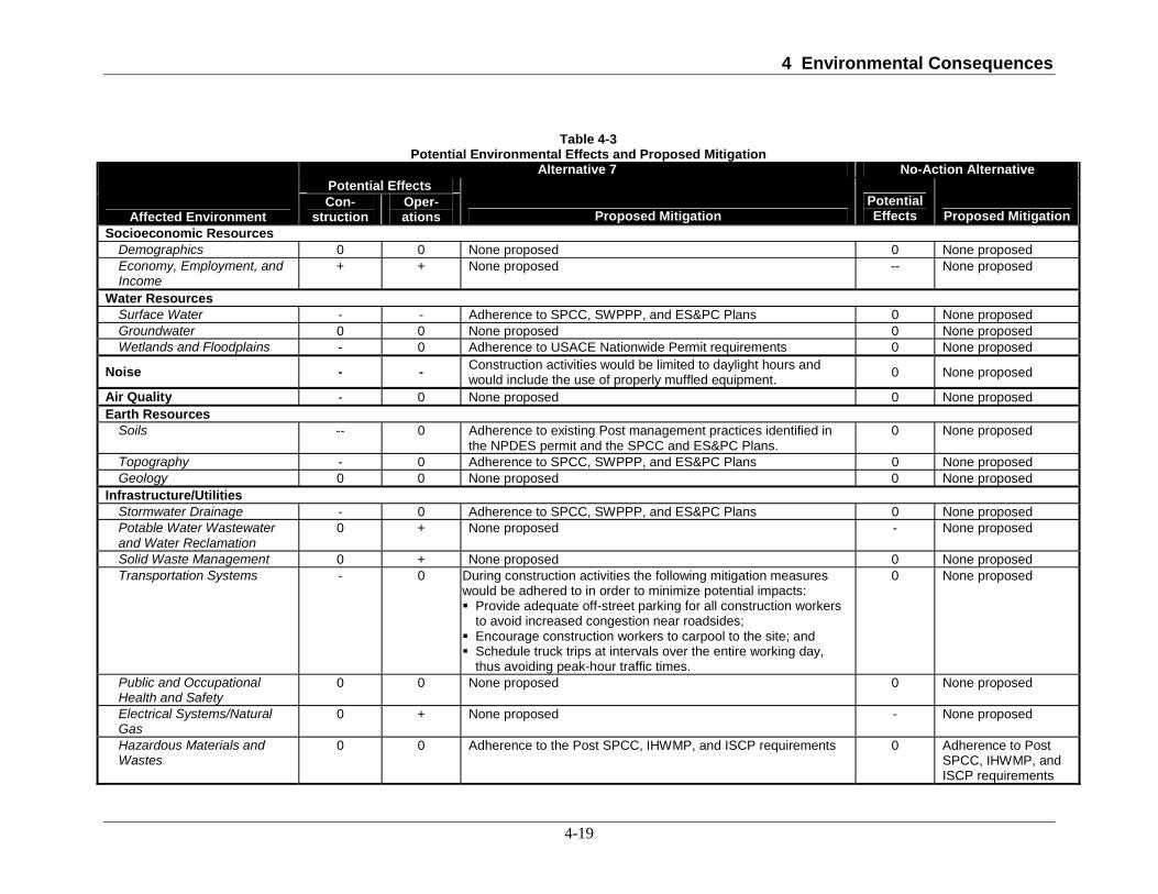
4 Environmental Consequences
4-19
Table 4-3 Potential Environmental Effects and Proposed Mitigation
Alternative 7 No-Action Alternative Potential Effects
Affected Environment Con-
struction Oper-ations Proposed Mitigation
Potential Effects Proposed Mitigation
Socioeconomic Resources Demographics 0 0 None proposed 0 None proposed Economy, Employment, and Income
+ + None proposed -- None proposed
Water Resources Surface Water - - Adherence to SPCC, SWPPP, and ES&PC Plans 0 None proposed Groundwater 0 0 None proposed 0 None proposed Wetlands and Floodplains - 0 Adherence to USACE Nationwide Permit requirements 0 None proposed
Noise - - Construction activities would be limited to daylight hours and would include the use of properly muffled equipment. 0 None proposed
Air Quality - 0 None proposed 0 None proposed Earth Resources
Soils -- 0 Adherence to existing Post management practices identified in the NPDES permit and the SPCC and ES&PC Plans.
0 None proposed
Topography - 0 Adherence to SPCC, SWPPP, and ES&PC Plans 0 None proposed Geology 0 0 None proposed 0 None proposed
Infrastructure/Utilities Stormwater Drainage - 0 Adherence to SPCC, SWPPP, and ES&PC Plans 0 None proposed Potable Water Wastewater and Water Reclamation
0 + None proposed - None proposed
Solid Waste Management 0 + None proposed 0 None proposed Transportation Systems - 0 During construction activities the following mitigation measures
would be adhered to in order to minimize potential impacts: Provide adequate off-street parking for all construction workers to avoid increased congestion near roadsides;
Encourage construction workers to carpool to the site; and Schedule truck trips at intervals over the entire working day, thus avoiding peak-hour traffic times.
0 None proposed
Public and Occupational Health and Safety
0 0 None proposed 0 None proposed
Electrical Systems/Natural Gas
0 + None proposed - None proposed
Hazardous Materials and Wastes
0 0 Adherence to the Post SPCC, IHWMP, and ISCP requirements 0 Adherence to Post SPCC, IHWMP, and ISCP requirements

4 Environmental Consequences
4-20
Table 4-3 Potential Environmental Effects and Proposed Mitigation
Alternative 7 No-Action Alternative Potential Effects
Affected Environment Con-
struction Oper-ations Proposed Mitigation
Potential Effects Proposed Mitigation
Biological Resources Vegetation - 0 Attempt to minimize impacts during initial design activities by
introducing green areas and landscaping throughout the project. 0 None proposed
Wildlife - 0 None proposed 0 None proposed Threatened and Endangered Species
0 0 None proposed 0 None proposed
Cultural Resources 0* 0
Mitigation for indirect effect of demolition of WWII buildings is covered under the Programmatic Memorandum of Agreement Among the United States Department of Defense, The Advisory Council on Historic Preservation, and the National Conference of State Historic Preservation Officers and no further mitigation is required.
0 None proposed
Land Use 0 0 None proposed 0 None proposed Environmental Justice 0 0 None proposed 0 None proposed Note: * Construction of the proposed shopping center would result in the relocation of the Soldiers’ Support Services to the vacated, existing PX facility (Holloway 2000). Soldiers’ Support Services is currently located in a group of World War II-era structures within an older part of the Post. Once Soldiers’ Support Services moves, the old structures formerly used by Soldiers’ Support Services would be demolished (Holloway 2000). See Cumulative Impacts Section 5.3.9 for additional information. Key: 0 = No effect - = Minor adverse -- = Moderate adverse --- = Significant adverse + = Minor positive ++ = Moderate positive +++ = Significant positive ES&PC = Erosion, Sedimentation, and Pollution Control. NPDES = National Pollutant Discharge Elimination System. SPCC = Spill Prevention, Control, and Countermeasures. SWPPP = Stormwater Pollution Prevention Plan. USACE = United States Army Corps of Engineers.
\\Talbdl1\publications\1400-1499\1460.ES06.01_T1474\July05 Final Draft\Final Draft Jul05.doc 5-1
5 Cumulative Impacts
The CEQ (1978) defines cumulative impacts as the “impact on the environment that results
from the incremental impact of the action(s) when added to other past, present, and reasonably
foreseeable future actions regardless of what agency (Federal or non-Federal) or person undertakes
such other actions.” The actions proposed under the alternatives in this EA, in addition to proposed
projects in the Columbus-Phenix City area, have the possibility to result in either negative or positive
impacts in a cumulative manner. These projects all occur within a well-defined and specific
geographical (spatial) region of influence (ROI), which is defined in the following subsection; in
addition, the projects are limited on a temporal basis since they all have the potential to be
implemented within a 20-year period as indicated by the planning documents obtained for the
individual cities, and therefore may increase the potential for cumulative effects. The overall ROI for
the purposes of this EA consists of the northern portion of the Post and the cities of Fort Benning and
Columbus, Georgia, and Phenix City, Alabama.
Reasonably foreseeable future actions in the ROI are separated by city and are discussed
below. Review of the Final Environmental Impact Statement for the Construction, Operation, and
Maintenance of the Digital Multi-Purpose Range Complex (DMPRC) was completed to assist with
the identification of projects associated with Fort Benning and the ROI.
5.1 Past and Present Actions within the Region of Influence The cities of Columbus, Georgia, and Phenix City, Alabama, are the sites of numerous
residential developments, commercial/retail facilities, industrial activities, and recreational
opportunities. The ongoing projects with the potential to impact the ROIs are discussed below.
Columbus and Fort Benning completed a “Land Exchange,” swapping two parcels of land,
known as the North Tract and the South Tract, for which an Environmental Impact Statement and a
Record of Decision were prepared. Columbus is currently developing the North Tract (24) land
conveyed to it, a 2,470-acre parcel located adjacent to the Fort Benning northwestern boundary line.

5 Cumulative Impacts
\\Talbdl1\publications\1400-1499\1460.ES06.01_T1474\July05 Final Draft\Final Draft Jul05.doc 5-2
Development of the North Tract will be primarily industrial, mixed with recreational land use. In
exchange, Fort Benning received the South Tract land (32), a 2,536-acre parcel located at the
southernmost end of the Post, which is currently being utilized by the Post for training and land
management (reforestation and habitat restoration) purposes; future use of the South Tract may also
include land-navigation training.
The installation of Anti-Terrorist/Force Protection Measures is a currently occurring project
on Fort Benning and consists of the construction of an enhanced physical security perimeter barrier
around the Post’s four cantonment areas to include either fence, guard rail, or utilization of existing
natural barriers, such as streams and steep ridges, and construct permanent access control points at the
Post’s seven entry points. Drainage for perimeter roads and erosion control measures will be required,
in addition to protective lighting at the seven access control points. An EA and Finding of No
Significant Impact were prepared for this project and are available for review at the EMD. Approximate
size of the overall project area is 20 to 25 acres.
The Barracks Project is located along Dixie Road, Main Post, Fort Benning. The new
barracks will be located across from the existing Easley and McAndrews ranges. The project will also
include the demolition of six existing buildings. An EA and Finding of No Significant Impact were
prepared for this project and are available for review at the EMD. Approximate size of the overall
project area is 30 to 35 acres.
The Digital Multi-Purpose Range Complex (DMPRC) will be constructed at the D13 area on
Fort Benning. The DMPRC will provide a state-of-the-art range facility for conducting advanced
gunnery exercises in a realistic training environment. Support facilities associated with the optimal
standard design for the DMPRC will be located on an adjacent area. The DMPRC design includes as
many as 22 water crossings (average dimensions: 350 feet long by 29 feet wide each), and some
vegetation removal on the construction site is required. The DMPRC will be constructed on
approximately 4,942 acres. An EIS was prepared for this project and is available for review at the
EMD.
Construction of the new infantry museum will occur on the land lying between South
Lumpkin and Fort Benning roads on the Post’s border with the City of Columbus. The existing
museum, located on Baltzell Avenue, Main Post, Fort Benning, would be reutilized in another
manner, but will not be demolished. An EA and Finding of No Significant Impact have been prepared
for this project and are available for review at the EMD. Approximate size of the overall project area
is 20 to 30 acres. Lastly, a communications tower is being constructed in the South Harmony Church
area, west of Cusseta Road and south of El Caney Road.

5 Cumulative Impacts
\\Talbdl1\publications\1400-1499\1460.ES06.01_T1474\July05 Final Draft\Final Draft Jul05.doc 5-3
In Columbus, safety improvements to the highway interchange at I-185/U.S. 280 (to the north
of Fort Benning) are currently underway and consist of reconstructing the interchange at I-185 and
U.S. 280. Safety improvements also include removing and replacing guardrails and possibly installing
medians along 10.5 miles of U.S. 280. Approximate size of the overall project area is 5 to 10 acres.
5.2 Reasonably Foreseeable Future Actions within the ROI
5.2.1 Fort Benning Community Several construction projects are planned for implementation on Fort Benning proper during
the same timeframe as this EA. Some of the projects have been previously identified in the Post’s
Master Plan and have been preliminarily assessed for environmental impacts via the Record of
Environmental Consideration (REC) process; however, each project is still pending final approval and
subsequent compliance with NEPA, except as indicated below. The projects determined to have the
potential to impact the ROIs are listed below. Fiscal Year (FY) refers to the period between 1 October
and 30 September of each year and is the time period the Army uses for budget phases.
Barracks Replacement, Kelley Hill, Phase III (FY05). Work would consist of the demolition of existing buildings (9043, 9046, 9047, 9053, 9054, 9055, 9057, 9058, and 9074), the construction of new facilities, and landscaping around the new facilities in the Kelley Hill area of Fort Benning. Approximate size of the overall project area is 10 to 15 acres.
Receptee Barracks (FY08). Work would consist of the construction of additional barracks, a dining facility, soldiers’ community center, and physical training building with a running track at Sand Hill. The project would also include the demolition of the existing dining facility. Approximate size of the overall project area is 10 to 15 acres.
Infantry Squad Battle Course (FY05). Work would include the conversion of an existing Fort Benning range (Galloway Range) into an Infantry Squad Battle Course (ISBC) and would include the removal/replacement and upgrading of existing targetry, the construction of associated support facilities, the demolition of currently existing temporary buildings on site, and associated utility placement. An EA and Finding of No Significant Impact were prepared for this project and are available for review at the EMD. Approximate size of the overall project area is 180 to 190 acres.
Infantry Platoon Battle Course (FY06). Work would consist of the construction of a new Infantry Platoon Battle Course (IPBC) in the A12 portion of Fort Benning and would include tree clearing, grading, cut-and-fill, construction of the range and target firing area, and placement of targetry, in addition to the construction/emplacement of support facilities, access roads and trails, and associated utilities. Approximate size of the overall project area is 1,000 acres.
Ammunition Supply Point Expansion (FY08). Work would consist of the construction of two aboveground general storage facilities, 11 earth-mounded ammunition storage igloos with associated loading platforms, two small quantity ammunition huts, and ammunition surveillance building, and forklift storage/recharge facilities at the existing Ammunition Supply Point (ASP)

5 Cumulative Impacts
\\Talbdl1\publications\1400-1499\1460.ES06.01_T1474\July05 Final Draft\Final Draft Jul05.doc 5-4
on Fort Benning. Work would also include the demolition of 19 structures currently existing within the Ammunition Supply Point compound. Approximate size of the overall project area is 10 to 15 acres.
Direct Support/General Support Consolidated Maintenance Facility (FY08). Work would consist of constructing an approximately 112,000-square foot equipment maintenance complex for the DOL. The Direct Support/General Support (DS/GS) Consolidated Maintenance Facility would located in the southwest quadrant of U.S. 280/27 and First Division Road. Approximate size of the overall project area is 10 to 15 acres.
Rehabilitation of North/South Maneuver Corridors (FY undetermined; pending funding approval). Work would consist of the rehabilitation of two existing maneuver corridors in the north and three existing maneuver corridors in the south for training utilization by the 3rd Brigade/3rd Infantry of Fort Benning. The areas are contained within the Oscar 1-15 training compartments in the north and the D2-16, L3, E3-4, and J6-7 training compartments in the south. These are existing maneuver areas that would have erosion control and soil stabilization measures conducted, in addition to selective thinning, in order to more fully support maneuvers by the mechanized vehicles. Approximate size of the overall project area is 5,000 acres.
Combined Club Facility (FY undetermined; pending funding approval). Work would consist of the demolition of the existing Follow Me Golf Course Clubhouse, construction of a new clubhouse to contain the combined functions of the Golf Course Club and Officer’s Club, and the redevelopment of the existing Follow Me Golf Course. Approximate size of the overall project area is 5 to 10 acres.
Digital Multi Purpose Training Range (also known as Hastings Range Upgrade; FY09 project, in planning phase only). Work would consist of upgrading the existing Hastings Range to a DMPTR; would include removal/replacement and upgrading existing targetry; expansion of the existing tank trails, construction of associated support facilities, the demolition of currently existing temporary buildings on site, and associated utility placement. Approximate size of the overall project area is 100 to 150 acres.
National Guard Pre-Ranger Complex Expansion; project in planning phase. The National Guard Pre-Ranger Complex is located within the South Harmony Church Area. The National Guard proposes to establish an area south of First Division Road that would be used for field training exercises.
Child Development Center; project in planning phase. Construction of a child development center designed for children ages 6 to 10 is proposed and would have capacity for 310 children for before and after school as well as summer and other no school days. This facility would replace the 70-year old Patch School, which has the capacity of 190 children. The Patch School cannot be expanded to support 120 additional spaces and the building needs costly repairs. However, the Patch School would be retained and reassigned to another activity/agency on Fort Benning. The overall project area is anticipated to cover 3 to 5 acres.
Operational Readiness Barracks Complex (Long-range future project; project in planning phase). A battalion-sized barracks complex to support current Reserve training missions (annual training) and supplement CONUS Replacement Center is proposed. The proposed capacity of the open bay barracks is 1,200 Soldiers (at 72 square feet per soldier) with a maximum capacity of 1,440 soldiers (at 60 square feet per soldier). The project also includes a dining facility with a 1,000 person capacity and an arms storage facility in accordance with Army standards.
Central Issue Facility; project in planning phase. Expansion of the existing Central Issue Facility on Main Post and construction of an annex in the Harmony Church Cantonment area is being proposed to begin in FY05. The existing Central Issue Facility (Building 2386) has

5 Cumulative Impacts
\\Talbdl1\publications\1400-1499\1460.ES06.01_T1474\July05 Final Draft\Final Draft Jul05.doc 5-5
exceeded its maximum storage capability due to Global War on Terrorism requirements. Tents are currently leased to store organizational clothing and individual equipment items, which is a security risk to the inventory stored in the tents.
Army Transformation at Fort Benning (Long-range future project; project in planning phase). The 3rd Infantry Division is currently undergoing a major reorganization as part of the Army transformation process. The Division’s three Brigades were divided into four smaller units (U.S. Army Forces Command 2004). While no plans currently exist that would affect any other units at Fort Benning, the Post must prepare for this contingency and comply separately with environmental planning requirements. Approximately 400 soldiers are expected to arrive at Fort Benning in the fall of 2005 and will become part of the 3rd Brigade of the 3rd Infantry Division. The Kelley Hill cantonment area supports the 3rd Brigade.
A more thorough evaluation of the ASP Expansion, IPBC, and the Rehabilitation of
Maneuver Corridors will be conducted via separate EAs or other appropriate NEPA actions for each
project; the other listed projects are in the preliminary planning phases only, but will undergo NEPA
evaluation in future documents. Other actions on Fort Benning, such as road and tank trail
maintenance, range and building maintenance, building renovations, unit motor pool maintenance,
troop training, and routine airfield activities, would continue in an ongoing manner on an annual
basis. These projects/actions are assessed for potential environmental impacts on a case-by-case basis
via the NEPA process.
5.2.2 Columbus-Buena Vista-Phenix City Community The projects listed below are those determined to have the potential for moderate adverse
impacts to resources within the ROI. The projects identified, but not included for study in this
document, may be viewed in the Columbus-Phenix City Transportation Improvement Plan, which is
available for review at the DPW.
Oxbow Meadows and Marina, Lumpkin Road, Columbus, Georgia (FY undetermined; tentatively scheduled to begin within the next 2 to 3 years). Work would consist of the further development of the Oxbow Meadows Environmental Learning Center by creating additional outdoor classrooms, a series of walking trails, a series of hiking trails, and pavilion, and the construction (to include dredge and fill) of a 350-slip capacity marina. Approximate size of the overall project area is 10 to 15 acres.
Phenix City Riverwalk Phase II, Phenix City, Alabama (FY undetermined). Work would consist of the construction of a hiking/biking trail between the 13th and 14th Street bridges in Phenix City. Approximate size of the overall project area is 5 to 10 acres.
Alternative Transportation System, Phase II, North Riverwalk, Columbus, Georgia (FY undetermined; scope of work decision pending implementation of Chattahoochee River Restoration Project, below). Work would consist of continuing to construct the hiking/biking trail (Riverwalk) northward along the Chattahoochee River from 12th Street to 14th Street. Approximate size of the overall project area is 5 to 10 acres.
Widening/Improvements to Buena Vista Road, Columbus, GA (FY07). Work would consist of widening and reconstructing 1.15 miles of an existing two- and four-lane road to a four
5 Cumulative Impacts
\\Talbdl1\publications\1400-1499\1460.ES06.01_T1474\July05 Final Draft\Final Draft Jul05.doc 5-6
through-lane system with turn lanes and medians, as required. Approximate size of the overall project area is 5 to 10 acres.
Widening/Improvements to St. Mary’s Road, Columbus, GA (FY05). Work would consist of widening 0.71 miles of a two-lane road to a three- and four-lane system, with intersection improvements as needed. Approximate size of the overall project area is 5 to 10 acres.
Chattahoochee River Restoration (FY05). Work would consist of breaching the Eagle-Phenix Dam and the City Mills Dam along the Chattahoochee River, in order to restore the historic and natural flow of water along this portion of the river, which extends from just north of the City of Columbus and down to its most southern edge. Approximate size of the project area is 2.5 miles (approximately 35 acres).
Another issue of concern with the potential to adversely affect the overall ROI is the Tri-State
Water Compact, a disagreement between Georgia, Alabama, and Florida concerning withdrawals of
water and public usage from the Chattahoochee-Flint-Appalachicola river systems. The
Chattahoochee River originates in the Blue Ridge Mountains of the Appalachian Highlands of
northeast Georgia, where it flows southwesterly for 120 miles before turning south and flowing
approximately 200 miles along the Georgia and Alabama borders, and a small part of the Florida
border. The Flint River includes Blackshear Dam and Lake, Flint River Dam, and Lake Worth. The
river originates south of Atlanta in Georgia’s Piedmont Province and flows southerly to the upper
Coastal Plain, where it joins the Chattahoochee River in Lake Seminole to form the Appalachicola
River. The Appalachicola River includes the USACE-operated Jim Woodruff Lock and Dam and
Lake Seminole along its length. The river lies entirely within the Coastal Plan along the 180 miles of
its length and flows south across northwest Florida from the Georgia to Appalachicola Bay in Florida.
5.3 Cumulative Effects Preliminary analysis indicated that the potential direct environmental and socioeconomic
effects associated with the preferred alternative are minor, while there would be no anticipated
cumulative effect to environmental justice and protection of children. In general, the construction,
operation, and maintenance of the new AAFES facility at the preferred alternative site would have no
significant adverse cumulative effects. During construction, effects to resources such as air quality,
noise, and wildlife would be short-term and temporary. However, when the construction of the
AAFES shopping center is analyzed together with past, ongoing, and potential future actions there is
potential to combine with other construction projects on-Post to result in a short-term localized
cumulative effect. However, because AAFES would be implementing measures such as utilizing
proper equipment; implementing BMPs to lessen air quality and noise impacts; and, would be
adhering to existing standard operating procedures and other guidance in place at Fort Benning, it is
anticipated to result in no or minor incremental impacts and would not be cumulatively significant.
5 Cumulative Impacts
\\Talbdl1\publications\1400-1499\1460.ES06.01_T1474\July05 Final Draft\Final Draft Jul05.doc 5-7
5.3.1 Socioeconomics The threshold level of significance for socioeconomic resources is the potential for the project
to result in a substantial population increase, displace residents, or result in a substantial change in
employment or income.
The Proposed Action, together with past, ongoing, and potential future actions, would be
expected to result in a positive minor cumulative effect to the surrounding local economy as well as
the Fort Benning economy. Because of the increase in the range of goods and services provided by
the facility coupled with the sale of tax-free goods, the facility would be more competitive with
surrounding shopping sites, which is expected to increase the customer base by approximately 2,000
customers per day. The facility would also be improved structurally and would eliminate the
operating space deficiency. Therefore, minor positive cumulative impacts are anticipated from the
implementation of the Proposed Action.
5.3.2 Water Resources The threshold level of significance for water resources is the potential of the project to cause
substantial changes in wetlands functions, groundwater or surface water flows, increased risk of
flooding, the potential to violate an applicable water quality standard for protection of fish and
wildlife, or degradation of a water body used as a potable water source.
Construction projects that disturb soils have the greatest potential to affect water quality if
sediments are washed into water courses. In particular, the construction of the ISBC, IPBC, and
DMPTR have the potential for minor to moderate adverse effects to wetlands and water quality within
the Fort Benning ROI; and the development of the marina at the Oxbow Learning Center would have
the potential for moderate adverse effects within the ROI. The rehabilitation of the Maneuver
Corridors on Fort Benning would result in positive effects to wetlands, due to the erosion control and
soil stabilization measures’ potential for reducing sedimentation into adjacent wetland areas.
Adherence to applicable federal, State, and local laws and following the guidelines identified in the
USACE Nationwide Permit and the ES&PC would help minimize the potential for adverse
cumulative effects. Therefore, no cumulative effects to water resources are expected.
5.3.3 Noise The threshold level of significance for noise is the increase of Zone III (incompatible) noise
contours where sensitive noise receptors (i.e., residences, hospitals, libraries) are located. During
construction of the AAFES facility, short-term localized noise would increase; however, the impact
would be minimized by the usage of appropriately maintained equipment and limiting construction to
5 Cumulative Impacts
\\Talbdl1\publications\1400-1499\1460.ES06.01_T1474\July05 Final Draft\Final Draft Jul05.doc 5-8
daylight hours. This would not result in incompatible noise activities to sensitive noise receptors
located within Zone 1.
Operation of the facility would result in minor long-term adverse impacts to noise. The
increase in noise levels would result primarily due to the proposed increase in the customer base at
the new shopping facility and the associated increase in the number of deliveries. When compared to
existing noise levels, the increase in noise levels associated with the increased traffic activity would be
expected to add a minimal increase to existing ambient noise levels within the project area, resulting in a
long-term minor adverse effect to noise levels within the immediate project area. However, when
analyzing cumulative effects consideration was given to other noise contributors and the potential to
result in a cumulative effect to the overall area. Because the other identified long-term noise
contributors are a significant distance from the preferred alternative site (Lawson Air Field,
approximately 4.8 miles, and Pierce Range, approximately 1.3 miles), the preferred alternative would
result in no cumulative effects to the noise environment.
5.3.4 Air Quality The threshold level of significance for air quality has been set at the same threshold used for
new stationary sources for the Prevention of Significant Deterioration (PSD) of air quality within a
region. While this threshold is used for stationary sources, it provides a reasonable measure of the
impact of a Proposed Action for air quality evaluation purposes. The sources of emissions related to
this project are mobile sources and stationary source emissions, which are not likely to change as a
result of this action.
If numerous construction projects were to occur concurrently with the site preparation and
construction work associated with the Proposed Action there could be a short-term, localized
cumulative effect to air quality. Increase in PM would be most prevalent because these activities
would include ground disturbance and travel over unpaved surfaces (fugitive dust – PM 10) as well as
increased traffic (combustion emissions PM 2.5). Although it is not possible to quantify the potential
additive impact of future potential projects with the current project, the resultant cumulative effects
would not be expected to significantly degrade the air quality in the area, but may result in minor
negative cumulative impacts.
5.3.5 Earth Resources The threshold level for earth resources (i.e., soils, topography, and geology) is any ground
disturbance or other activities that would violate applicable federal or State laws and regulations, such
as the Georgia Erosion and Sediment Control Act, and the potential for Notices of Violation for the

5 Cumulative Impacts
\\Talbdl1\publications\1400-1499\1460.ES06.01_T1474\July05 Final Draft\Final Draft Jul05.doc 5-9
failure to receive applicable state permits, such as the NPDES construction permit under the Georgia
Erosion and Sediment Control Act, prior to initiating the Proposed Action.
Many of the projects (such as highway improvements, future operational facilities, new
barracks, and other construction-related projects) occurring within the ROI would cause ground
disturbance. These activities increase the potential for soil erosion if stabilization were not to occur.
However, Fort Benning applies several BMPs (including those noted in Section 4.3) that would
minimize soil disturbance and actively prevent the potential for erosion and other types of soil
degradation. With the application of these types of BMPs, soil loss would be limited to short-term
effects that would result in minor cumulative adverse effects.
5.3.6 Infrastructure and Utilities If numerous construction projects were to occur concurrently with the site preparation and
construction work associated with the Proposed Action there could be a cumulative effect to
transportation. During construction of the Proposed Action, traffic volume would increase slightly in
the project area due to on-road use by construction equipment, construction workforce vehicles, and
vehicles delivering construction materials. To minimize the minor adverse effects to the transportation
system, the contractor would implement mitigation measures as identified in Section 4.8. There would
be no anticipated measurable increase in utility demand during the construction of the Proposed Action.
Operation of this facility would result in an increase in demand of utility services; however,
existing utility service providers have capacity to adapt to the cumulative demands associated with
the proposed action and other projects. Distribution systems to bring those services to project sites
may be required. Environmental disturbances associated with extending utility services to new
locations would be addressed in future NEPA documents; however, at this time, no significant
adverse cumulative effects are anticipated with the proposed action. Traffic during the operation of
the Proposed Action would increase; however would only be a small percentage. Therefore, these
effects associated with both the construction and the operation of the Proposed Action would result in
no cumulative impacts.
5.3.7 Hazardous Materials and Wastes The threshold level of significance for hazardous materials and wastes is the potential to
substantially affect human health, safety, or the environment.
The majority of the projects would only require the use of pesticides, petroleum, oils, and
lubricants in association with construction and equipment maintenance activities. Fort Benning
would continue to implement their BMPs for hazardous materials and waste use and adhere to
5 Cumulative Impacts
\\Talbdl1\publications\1400-1499\1460.ES06.01_T1474\July05 Final Draft\Final Draft Jul05.doc 5-10
rigorous regulations for the use, storage, handling, analysis, and disposal of such wastes and comply
with applicable requirements. Therefore, no cumulative adverse impacts from hazardous materials
and waste would be anticipated.
5.3.8 Biological Resources The threshold level of significance for federally protected species would include the
disruption of normal behavior patterns or disturbance to habitat at a level that would substantially
impact the Post’s ability to either avoid jeopardy or to conserve and recover the species. The
threshold level of significance for vegetation is removal in amounts that will alter the habitat in a
manner detrimental to the species that live there.
Construction of the barracks on Main Post, Sand Hill and Kelly Hill, ISBC, IPBC, DMPRC,
DMPTR; and the development of Oxbow Meadows and the marina along with the continued
development of the North Tract would have the potential for minor to moderate adverse effects to
biological resources (i.e., federal or state listed protected species or their habitat) within the Fort
Benning area. Continued adherence to INRMP guidance (US Army 2001) in the siting and
construction of new facilities would assure the avoidance of significant cumulative impacts.
Furthermore, the continued implementation of conservation measures for the RCW on Fort Benning
in consultation with the USFWS, as needed for current and future projects will help to ensure that the
RCW population remains on track towards recovery or increases. Minimal RCW habitat would be
lost as a result of the Proposed Action. Overall, implementation of the Proposed Action would result
in no potential for incremental impacts from ongoing activities and no cumulative adverse impacts to
biological resources.
5.3.9 Cultural Resources The threshold level of significance for cultural resources is the violation of applicable
Federal laws and regulations, such as the National Historic Preservation Act (NHPA), the
Archaeological Resources Protection Act (ARPA), the Native American Grave Protection and
Repatriation Act (NAGPRA), and others.
No incremental impacts to cultural resources in association with the proposed action are
anticipated. Once the proposed PX facility is completed, Soldiers’ Support Services would be
relocated to the vacated, existing PX facility (Holloway 2000). Soldiers’ Support Services is currently
located in a group of World War II-era structures within an older part of the Post. Once Soldiers’
Support Services moves, the old structures formerly used by Soldiers’ Support Services would be
demolished (Holloway 2000), which would be considered an adverse effect of the project. The
5 Cumulative Impacts
\\Talbdl1\publications\1400-1499\1460.ES06.01_T1474\July05 Final Draft\Final Draft Jul05.doc 5-11
demolition of these structures would be covered under the 1986 Programmatic Memorandum of
Agreement (USDOD 1986). Other projects in the ROI would follow applicable cultural resource
requirements and procedures. Therefore, the implementation of the Proposed Action at the preferred
alternative site would have no affect on any resources eligible for listing on the NRHP, nor would any
cumulative adverse impacts occur in conjunction with past, present, or foreseeable projects. If during
construction, previously unidentified cultural resources were discovered, activities at that site would
be stopped and the Fort Benning archaeologist would be notified. Coordination with all the
appropriate Federal, state, and local agencies as well as American Indian Tribes, would be conducted
to determine the importance of the site and how it should be treated before construction activities at
the site resume.
5.3.10 Land Use The threshold level of significance for land use includes evaluating consistency with land use
plans, and compatibility with existing and future surrounding land uses.
New development would preclude the use of land for other purposes; however, historically
land within Fort Benning has undergone many changes. This pattern is likely to continue. The
projects identified as potentially occurring within the reasonably foreseeable future are compatible
with existing and historic military land uses. Therefore, no adverse cumulative impacts to land use
are anticipated with the Proposed Action.
5.3.11 No-Action Alternative The implementation of Alternative 8, the no-action alternative, would result in no additional
construction activities. Additionally, the no-action alternative would allow for the continued
operation of the existing PX and Commissary at Fort Benning. As a result, there would be no
anticipated change to the baseline cumulative effects.

\\Talbdl1\publications\1400-1499\1460.ES06.01_T1474\July05 Final Draft\Final Draft Jul05.doc 6-1
6 Conclusions and Recommendations
A new AAFES shopping center is needed to replace the existing facility, which is outdated,
located in confined space, highly congested, and too small to adequately serve the customer base. The
preferred alternative site and other alternative sites have been evaluated in this EA with respect to
numerous natural, cultural, physical, and socioeconomic resources. The following conclusions have
been drawn from the findings of the EA.
6.1 Alternative 8: The No-Action Alternative (Status quo) Under Alternative 8, the no-action alternative (status quo), a new shopping facility would not
be constructed on the Post to serve the military and associated eligible shopping population. The
military community that shops at Fort Benning would continue to use the existing facility that is
limited in space and offers an unsatisfactory range of services and merchandise. The no-action
alternative would not meet the needs of the military community, who may be forced to shop for some
goods and services at commercial establishments located off the Post. This would be both
inconvenient and inefficient for active military personnel, their families, and other shoppers eligible
to shop at the PX. Although this alternative would have lesser environmental impacts than the
Proposed Action, it would not meet Fort Benning community needs and, therefore, is not
recommended.
6.2 Alternative 7: The Preferred Alternative Alternative 7, the preferred site, includes construction of a new 218,000-square foot building for
use by authorized individuals at Fort Benning. The Proposed Action would consist of construction,
operation, and maintenance of a shopping center containing a main store and a food court with
popular fast food establishments. Other services in the proposed facility would include a barbershop,
beauty shop, pharmacy, alterations shop, optometrist/eye care office, flower shop, one-hour photo
store, trophy shop, watch repair, nutrition center, shoe store, and amusement arcade. This facility
6 Conclusions and Recommendations
\\Talbdl1\publications\1400-1499\1460.ES06.01_T1474\July05 Final Draft\Final Draft Jul05.doc 6-2
would satisfy the shopping needs of the Fort Benning community and the needs of other shoppers
eligible to shop as this complex. It would eliminate the need for military personnel and their family
from having to shop at commercial establishments off the Post.
After evaluating the alternatives, Alternative 7 meets the environmental and siting criteria for
the siting of the Proposed Action. Implementation of this alternative would require the long-term
conversion of 18.25 acres of undeveloped land to a shopping mall facility. Long-term localized
adverse noise impacts would occur during the operation of the facility resulting from increased
deliveries and vehicular traffic; however, these would be minor due to limiting construction to
daylight hours. Minor impacts during construction activities would include localized noise impacts
and also increased vehicular traffic associated with construction activities. Short-term moderate
adverse construction impacts may result in an increase in soil erosion resulting in moderate adverse
impacts to soils. Furthermore, recent wetland delineations concluded that 0.15 acres of wetlands exist
on the preferred site of the Proposed Action, of which 0.114 acres would be impacted. Additionally, a
total of 26 linear feet of intermittent stream would be impacted by the Proposed Action. Based on
their review of the wetland delineation (see Appendix A), the USACE granted AAFES approval to
use Nationwide Permit #18 for this project. Also, vegetation would be removed including a very
small patch of RCW habitat that is not currently associated with an active cluster. The effects that the
preferred alternative would have on the resources identified above are not considered to be
significant. Mitigation measures would include the strict adherence to existing plans (SPCC, SWPPP,
IHWMP, and ISCP), guidelines, and permit requirements (NPDES and USACE). In addition, during
construction activities, proper equipment would be used to minimize noise and air emissions.
Furthermore, construction vehicles would be parked off-street, construction workers would be
encouraged to carpool, and truck trips would be scheduled at intervals over the entire working day,
thus avoiding peak-hour traffic times. Positive impacts are expected to some categories of utilities
and socioeconomics.
Based on the findings of this EA, the preferred alternative of constructing the AAFES
shopping facility at the site across from the existing PX/commissary would not result in significant
impacts to any natural, cultural, physical, or socioeconomic resource, and would be preferred over the
No-Action Alternative.

\\Talbdl1\publications\1400-1499\1460.ES06.01_T1474\July05 Final Draft\Final Draft Jul05.doc 7-1
7 List of Preparers
The AAFES liaison associated with the preparation of this EA is:
Greg Smith Army and Air Force Exchange Service HQ AAFES 3911 South Walton Walker Boulevard Dallas, TX 75236-1598 (214) 312-2109
The contractor responsible for preparing this EA is:
Ecology and Environment, Inc. 1950 Commonwealth Lane Tallahassee, FL 32303
The following individuals contributed to the preparation of this EA:
Name Role Project Responsibility Gene Stillman Project Manager
Michael Gartman Senior Wetlands Biologist Wetland Delineation and Report
Laurie Kutina Air Quality Specialist Air Quality, Sections 3 and 4
Gina Edwards Senior Technical Editor Document Control and Editing
Cindy Dick Graphic Artist Figures
Kent Cain GIS Technician Maps, Figures

7 List of Preparers
\\Talbdl1\publications\1400-1499\1460.ES06.01_T1474\July05 Final Draft\Final Draft Jul05.doc 7-2
This page left blank intentionally.

\\Talbdl1\publications\1400-1499\1460.ES06.01_T1474\July05 Final Draft\Final Draft Jul05.doc 8-1
8 Persons and Agencies Consulted
The following agencies and persons were consulted during the preparation of this EA.
8.1 Fort Benning Barron, Michael, USFWS, Fort Benning Georgia.
Brown, John, NEPA Program Manager, Environmental Management Division, Fort Benning, Georgia.
Buford, Rusty, GIS Coordinator, Environmental Management Directorate, Fort Benning, Georgia.
Chauvey, Patrick, Chief, Environmental Programs Management Branch, Environmental Management Division, Fort Benning, Georgia.
Gustafson, Polly, Air Quality Program Manager, Environmental Programs Branch, Environmental Management Division, Fort Benning, Georgia.
Hamilton, Dr. Christopher E., Staff Archaeologists/Cultural Resources Program Manager, Environmental Programs Branch, Environmental Management Division, Fort Benning, Georgia.
Hollon, Gary, Soil Control/Wetlands, Environmental Programs Branch, Environmental Management Division, Fort Benning, Georgia.
Holloway, Ken, Chief, Real Property Division, Directorate of Public Works, Environmental Programs Branch, Environmental Management Division, Fort Benning, Georgia. Kendrick, Melissa, NEPA Coordinator, Environmental Programs Branch, Environmental Management Division, Fort Benning, Georgia.
Pearce, Neil, DERA, Site Contamination Program Manager, Environmental Programs Branch, Environmental Management Division, Fort Benning, Georgia.
Seda, Felix, Spill/ECAS Program Manager, Environmental Programs Branch, Environmental Management Division, Fort Benning, Georgia.
Swiderek, Pete, Chief, Conservation Branch, Environmental Management Division, Fort Benning, Georgia.

8 Persons and Agencies Consulted
\\Talbdl1\publications\1400-1499\1460.ES06.01_T1474\July05 Final Draft\Final Draft Jul05.doc 8-2
Veenstra, M. Linda, J.D. Environmental Attorney, Office of the Staff Judge Advocate, Fort Benning, Georgia.
Webb, James, Chief, Engineering Division, DPW, Fort Benning, Georgia
8.2 Army Air Force Exchange Service McCauley, Harry, Army and Air Force Exchange Service, Dallas, Texas.
Smith, Greg, Environmental Engineer, Dallas, Army and Air Force Exchange Service Headquarters, Dallas, Texas.
8.3 State of Georgia and Federal Agencies US Fish and Wildlife Service North Georgia Office 247 South Milledge Avenue Athens, GA 30605 US EPA Atlanta Federal Building 61 Forsyth Street Atlanta, GA 30303-3104 Commander, Savannah Corps District PO Box 889 Savannah, GA 31401 Georgia State Clearinghouse Office of Planning and Budget 270 Washington Street, S.W., 8th Floor Atlanta, GA 30334 Georgia Department of Natural Resources Erosion and Sediment Control 205 Butler Street, SE Suite 1038, Floyd Towers East Atlanta, GA 30334 Georgia Department of Natural Resources Historic Preservation Division 47 Trinity Avenue, S.W., Suite 414-H Atlanta, GA 30334-9006
\\Talbdl1\publications\1400-1499\1460.ES06.01_T1474\July05 Final Draft\Final Draft Jul05.doc 9-1
9 References
Army Regulation (AR) 200-2, 2002, Environmental Effects of Army Actions, March 2002.
Barron, Michael, 2005, United States Fish and Wildlife Service, Fort Benning, Georgia, personal communication, telephone conversation, April 1, 2005, regarding red-cockaded woodpecker habitat, with Gene Stillman, Ecology and Environment, Tallahassee, Florida .
Beachler, Mark, 2000, Martin Beachler Architects, personal communication, telephone and electronic communications with URS Group, Inc., Atlanta, Georgia staff regarding site design and site development, October and November 2000.
Brent, John J., 2000, Chief, Environmental Management Division, Fort Benning, personal communication, letter to U.S. Fish and Wildlife Service, March 20, 2000.
__________, 2001, Chief, Environmental Management Division, Fort Benning, personal communication, letter to U.S. Fish and Wildlife Service, January 16, 2001.
Carveza, Carmen, 2000, City Manager, City of Columbus, personal communication with URS Group, Inc., Atlanta, Georgia staff regarding potential economic effect from proposed Post Exchange at Fort Benning, November 1, 2000.
Chambers, Peggy, 2004, personal communication, Georgia Department of Environmental Protection, Atlanta, Georgia, telephone conversation regarding stream buffer variance, October 13, 2004, with Gene Stillman, Ecology & Environment, Inc., Tallahassee, Florida.
Columbus Convention and Visitors Bureau, 2002, Internet Site at http://www.visitcolumbusga.com
Council on Environmental Quality (CEQ), 1978, Final Regulations for Implementing the National Environmental Policy Act (NEPA), 30 Code of Federal Regulations (CFR) 1500-1508, November 29, 1978.
Davis, K.R., J.C. Donahue, R.H. Hutcheson, and D.L. Waldrop, 1988, Most Significant Ground-Water Recharge Areas of Georgia: Georgia Geologic Survey Hydrologic Atlas 18, 1 plate.
El Dorado County (California) Air Pollution Control District (El Dorado APCD), 2002, Guide to Air Quality Assessment, Chapter 4, Construction Activities-Air Quality Impacts and Mitigation, February 2002.
Environmental Data Resources, Inc. (EDR), 2000, EDR-Radius Map (Environmental Database Report), Inquiry No. 558159.3s, October 31, 2000.

9 References
\\Talbdl1\publications\1400-1499\1460.ES06.01_T1474\July05 Final Draft\Final Draft Jul05.doc 9-2
Environmental Laboratory, 1987, United States Corps of Engineers Wetland Delineation Manual, Technical Report Y-87-1, Department of the Army, Waterways Experiment Station, Vicksburg, Mississippi.
Federal Clean Air Act, Sections 10, 176, and 309. 42 United States Code (USC) 7400 et seq.
Fisher, Tom, 2003, United States Army Corps of Engineers, personal communication with Gene Stillman, Ecology and Environment, Inc., Tallahassee, Florida, August 21, 2003.
Fort Benning Land Management Branch, 2000, Geographic Information System (GIS) soil and geology layers, November 2000.
Fort Benning, “Integrated Natural Resources Management Plan (INRMP,” prepared by the Department of Public Works, Environmental Management Division, Conservation Branch, 2001.
Fort Benning, 2003a, U.S. Infantry Internet site at http://www-benning.army.mil, prepared by the Directorate of Operations and Training (G-3), July 7, 2003.
Fort Benning, 2003b, Title V air permit effective June 13, 2003, #9711-215-0021-V-01-0.
Fort Benning, 2003c, Infantry, U.S. Army Infantry Homepage, National Infantry Museum, Infantry History at http://www.infantry.army.mil/museum/misc/inf_heritage.htm, prepared by the Directorate of Operations and Training (G-3), May 9, 2003.
Fort Benning, 2004, Final Environmental Impact Statement for the Construction, Operation, and Maintenance of a Digital Multi-Purpose Range Complex (DMPRC), April 2004.
Freer, Jennifer A., 1994, An Intensive Archaeological Survey of the Proposed New Family Housing, Compartments AA, BB6 and Cantonment, Fort Benning, Georgia, prepared for U.S. Army Corps of Engineers, Savannah District and Fort Benning.
Georgia Department of Natural Resources (GA DNR), no date, Internet site at http://www.dnr.state.ga.us/.
__________, 1986, A Ground-Water Management Plan for Georgia, Circular 11, Georgia Geologic Survey.
Greater Columbus Georgia Chamber of Commerce, 2000, Internet site at http://208.62.83.218/, reached by linking from http:www.columbusga.com.
Gustafson, Polly, 2000a, Clean Air, Compliance Section, personal communication, fax regarding Risk Management Plan -Worst-Case Release Analysis of Chlorine Release at Water Treatment Plant at Fort Benning, October 27, 2000.
__________, 2000b, Clean Air, Compliance Section, Fort Benning, personal communication with URS Group, Inc., Atlanta, Georgia staff regarding air quality at Fort Benning, October 17 and November 1, 2000.
__________, 2000c, Clean Air, Compliance Section, personal communication, fax regarding Radon Testing at Fort Benning (with attachments), November 2, 2000.

9 References
\\Talbdl1\publications\1400-1499\1460.ES06.01_T1474\July05 Final Draft\Final Draft Jul05.doc 9-3
Gustafson 2005, Air Quality Program Manager, Environmental Programs Branch, Environmental Management Division, Fort Benning, personal communication with Gene Stillman, Ecology & Environment, Inc., Tallahassee, Florida, March 16, 2005. Herrick and Vorhis, 1963, Subsurface Geology of the Georgia Coastal Plan, United States Geological Survey, Circular 25.
Hill-Staton Engineers, 1999, Subsurface Investigation, New Shopping Center, Marne Road, Fort Benning, Georgia, September 1999.
Holloway, Ken, 2000, Chief, Real Property Division, Directorate of Public Works, personal communication with URS Group, Inc., Atlanta, Georgia staff during site visit and telephone communications regarding master planning activities at the installation, land use, and entranceway, October 23 and 26, and November 16, 2000.
__________, 2001, Master Planner and Acting Chief of Engineering Division, Real Property Master Planning Branch, Fort Benning, personal communication with URS Group, Inc., Atlanta, Georgia staff regarding proposed construction projects at Fort Benning, June 26, 2001.
Jackson, Charlotte S., 2000, DCA Chief Support Services and Lodging Division, Fort Benning, personal communication, facsimile communication containing information on the installation population profile at Fort Benning, November 7, 2000.
Kendrick, Melissa B., 2001, Environmental Specialist, NEPA Coordinator, Fort Benning, personal communication, electronic mail regarding example of cumulative impacts section and proposed construction projects at Fort Benning, June 19, 2001.
Ministry of the Environment (MOE). 2004. Canadian Ministry of the Environment, Fine Particulate Matter website. Ontario, Canada. Accessible at: http://www.airqualityontario.com/science/pollutants/particulates.cfm.
Microsoft Corporation, 2003, Encarta Internet site at http:www.encarta.msn.com.
Military Police, 2000, Fort Benning, personal communication with URS Group, Inc., Atlanta, Georgia staff regarding internal/external roads and security at Fort Benning, October 27, 2000.
National Environmental Policy Act (NEPA) of 1969, 42 USC 4321-4370a.
Natural Resources Conservation Service (NRCS), 2000, Floodplain information for Fort Benning provided by the Buena Vista, Georgia Field Office, November 21, 2000.
Nichols, Walter, 2000, Waste Section, Fort Benning, personal communication with URS Group, Inc., Atlanta, Georgia staff regarding solid waste management, October 30, 2000.
Pearce, Neil, 2000, Installation Restoration Program (IRP), Fort Benning, personal communication with URS Group, Inc., Atlanta, Georgia staff regarding hazardous materials and wastes, and groundwater monitoring, November 21, 2000.
Peck, Michael F., Charles N. Joiner, John S. Clarke, and Alan M. Cressler, 1990, Ground-Water Conditions in Georgia, 1989, Open-File Report 90-706, United States Geological Survey.
9 References
\\Talbdl1\publications\1400-1499\1460.ES06.01_T1474\July05 Final Draft\Final Draft Jul05.doc 9-4
Pollard, Lin D., and Robert C. Vorhis, 1980, The Geohydrology of the Cretaceous Aquifer System in Georgia, Georgia Department of Natural Resources.
Taylor, Larry, 2000a, Project Manager, AAFES, personal communication, electronic mail to URS Group, Inc., Atlanta, Georgia staff responding to questions regarding project design, site development, and purpose and need for project, November 20, 2000.
__________, 2000b, Project Manager, AAFES, personal communication with URS Group, Inc., Atlanta, Georgia staff regarding proposed cost of new post exchange facility at Fort Benning, October 27, 2000.
Terrain Analysis Center (TAC), 1976, Fort Benning Georgia Terrain Analysis, U.S. Army Engineer Topographic Laboratories, Fort Belvoir, Virginia.
United States Army Forces Command, 2004, U.S. Army Forces Command (FORSCOM), Executive Order, 3rd Infantry Division (3ID) Conversion to the Army Modular Design. 7 March.
United States Department of Agriculture (USDA), 1997, Soil Survey of Chattahoochee and Marion Counties, Georgia, November 1997.
United States Department of Defense (DoD) Instruction 4715-9, 1996, Environmental Planning and Analysis, May 3, 1996.
__________, the Advisory Council on Historic Preservation, and the National Conference of State Historic Preservation Officers. 1986 Programmatic Memorandum of Agreement (PMOA).
__________, 2003, Defense Almanac, Internet site containing information about population distributions in the Armed Forces at http://www.defenselink.mil/pubs/almanac/almanac/people, June 27, 2003.
United States Department of the Army (Army), 2001, Integrated Training Area Management Internet Site at http://www.army-itam.com/workshop/7wkshp/abstractbook/papers/davo.htm.
United States Environmental Protection Agency (EPA), 1995, “Compilation of Air Pollutant Emission Factor” AP-42 (5th ed.), Office of Air Quality Planning and Standards. Section 13, January 1995.
__________, 1971, “Noise from Construction Equipment and Operations, Building Equipment, and Home Appliances” PB 206717.
__________, July 2, 2003, Internet site at http://www.epa.gov/iedweb00/radon/zonemap.html.
United States Fish and Wildlife Service (USFWS), 1989, Guidelines for Preparation of Biological Assessments and Evaluations for the Red-cockaded Woodpecker, September 1989.
Webb, James D., 2005, Chief, Engineering Division, DPW, Fort Benning, Georgia, personal communication, electronic correspondence, May 4, 2005, regarding projects schedule identified in the cumulative impacts, with Gene Stillman, Ecology and Environment, Tallahassee, Florida

9 References
\\Talbdl1\publications\1400-1499\1460.ES06.01_T1474\July05 Final Draft\Final Draft Jul05.doc 9-5
Wilkins, Joe, 2000, Compliance Section, Fort Benning, personal communication with URS Group, Inc., Atlanta, Georgia staff regarding water quality and waste water resources at Fort Benning, November 6, 2000.
Yahoo!, 2003, Yahoo! Yellow Pages, Internet site at http://yp.yahoo.com.
Yntema, John, 2000, Air Quality Branch, Georgia Environmental Protection Division, personal communication with URS Group, Inc., Atlanta, Georgia staff regarding boiler information at Fort Benning, November 2, 2000.

\\Talbdl1\publications\1400-1499\1460.ES06.01_T1474\July05 Final Draft\Final Draft Jul05.doc A-1
Appendix A
Wetlands Jurisdictional Delineation
United States Waters/Wetlands Identification Report
Construction of a Shopping Center Fort Benning, Chattahoochee County, Georgia
June 2004
Prepared For: Army Air Force Exchange Service (AAFES)
Prepared by:
Wetlands Jurisdictional Delineation Fort Benning, Georgia
14:1460.ES06.01_T1474
iii
Table of Contents
List of Acronyms and Abbreviations.............................................................................v 1.0 Introduction ................................................................................................... 1 2.0 Project Area Description .............................................................................. 1
2.1 Project Area Vegetation.....................................................................................1 2.2 Project Area Hydrology .....................................................................................2 2.3 Project Area Soils ..............................................................................................3
3.0 Wetlands Delineation Procedures ............................................................... 4
3.1 Preliminary Data Gathering ...............................................................................4 3.2 Field Identification.............................................................................................5
4.0 Results of Investigation................................................................................ 6
4.1 Area A................................................................................................................6 4.2 Area B ................................................................................................................7 4.3 Area C ................................................................................................................7 4.4 Area D................................................................................................................8
5.0 Conclusion..................................................................................................... 8 6.0 References.................................................................................................... 9 Attachments A Figures ....................................................................................................... A-1
1 Site Location Map, Ft. Benning, Georgia 2 Jurisdictional Waters, Ft. Benning, Georgia 3 Observation Point Locations, Ft. Benning, Georgia 4 Aerial Overview, Ft. Benning, Georgia 5 Potential Wetland Impacts, Ft. Benning, Georgia
B Dataforms .................................................................................................. B-1 C Site Photographs ...................................................................................... C-1
Wetlands Jurisdictional Delineation Fort Benning, Georgia
14:1460.ES06.01_T1474
v
List of Acronyms and Abbreviations
CFR Code of Federal Regulations
CWD coarse wood debris
DGPS differential Global Positioning System
E & E Ecology and Environment, Inc.
EPA United States Environmental Protection Agency
FEMA Federal Emergency Management Agency
GIS Geographic Information Systems
GPS Global Positioning System
I-185 Interstate 185
NWI National Wetlands Inventory
OHW ordinary high water
SCS Soil Conservation Service
USACE United States Army Corps of Engineers
USDA, NRCS United States Department of Agriculture, Natural Resource Conservation Service
USFWS United States Fish and Wildlife Service
USGS United States Geological Survey
Wetlands Jurisdictional Delineation Fort Benning, Georgia
14:1460.ES06.01_T1474
1
1.0 Introduction Ecology and Environment, Inc. (E & E) was retained by Fort Benning to conduct an identification of Waters of the United States, including wetlands, on a site proposed for shopping center construction. The project was tasked in order to locate all waters/wetlands in the potential area of impact to help plan the shopping center design layout for minimizing impacts. The project is located in the northwestern portion of the U.S Army’s Military Reservation at Fort Benning, Georgia. The site is east of U.S. Interstate 185 (I-185) at the 1-mile marker, and adjacent to the existing commissary facility (Attachment A, Figure 1). The site is approximately 50 acres in size; however, the project “footprint” will only impact 18.25 acres of the site. The surveyed area extends beyond the specified project boundaries to ensure that all jurisdictional areas within reasonable proximity to the project are assessed. In addition, the boundary extension will allow project engineers various options in minimizing the potential impacts to jurisdictional areas. 2.0 Project Area Description The site is located on Fort Benning property within the limits of the main base area. The property has been disturbed by apparent past logging activities and utilities installation. Numerous logging roads and two utility line corridors cross the surveyed area. Access to the property is via an existing unimproved road from Marne Road, across the road from the existing commissary facility. The site is situated atop a ridge running north/south, with significant variation in local elevation (Attachment A, Figure 2). According to United States Geological Survey (USGS) topographic elevations, the lowest elevation of the area surveyed is 250 feet, while the highest elevation is 368 feet. The site is nearly level along the ridge top. Conversely, ridge slopes range up to 30% grade. Numerous “logging” roads exist along ridge contours and atop the ridge. 2.1 Project Area Vegetation The project site is located in northern Chattahoochee County within 1 mile of the Upatoi River. Vegetation differs between surveyed extents due to varying elevations across the site. Few areas have been altered from the natural land cover. Aside from two small cleared corridors, the site remains comprised of forested and herbaceous areas. The forested areas occur in the lower elevations and in areas not cleared by logging atop the ridge. Deciduous hardwoods occur in the lower elevations where sunlight is less plentiful. Higher topographic areas exhibit more evergreen pine and associated herbaceous vegetation.
Wetlands Jurisdictional Delineation Fort Benning, Georgia
14:1460.ES06.01_T1474
2
Deciduous area tree species include red maple (Acer rubrum), tupelo (Nyssa spp.), sweetgum (Liquidambar styraciflua), yellow poplar (Liriodendron tulipifera), sweetbay magnolia (Magnolia Virginiana), silver maple (Acer saccharinum), sycamore (Platanus occidentalis), umbrella magnolia (Magnolia tripetala), bayberry (Myrica cerifera), willow oak (Quercus phellos), water oak (Quercus nigra), white oak (Quercus alba), Southern red oak (Quercus falcata), sasafrass (Sassafras albidum), American holly (Ilex opaca), mountain laurel (Kalmia latifolia), and river birch (Betula nigra). Other non-tree species include Chinese privet (Ligustrum sinense), common greenbriar (Smilax rotundifolia), summer grape (Vitis aestivalis), needle rush (Juncus effuses), cinnamon fern (Osmunda cinnamomea), signal grass (Brachiaria platyphylla), Virginia creeper (Parthenocissus quinquefolia), and poison ivy (Toxicodendron radicans). The ridge top includes species such as loblolly pine (Pinus taeda), shortleaf pine (Pinus echinata), white oak, Southern red oak, red maple, rough-leaf dogwood (Cornus asperifolia), cedar elm (Ulmus crassifolia), pin oak (Quercus palustris), and yellow hawthorn (Crataegus flava). Groundcover species in this area include Southern dewberry (Rubus trivialis), groundsel (Senecio spp.), sagegrass (Artemisia spp.), Bahia grass (Paspalum nodatum), and annual ragweed (Ambrosia artemisiifolia). 2.2 Project Area Hydrology The project area is located in a high-relief area typical of west-central Georgia. Slopes range from nearly flat to 30% on ridge slopes. Due to the relatively high relief, storm run-off is rapid and well drained. The project lies within the Middle Chattahoochee-Walter F. George Rese Watershed. Water bodies within the watershed include the Chattahoochee River, Upatoi Creek, and Choctawhatchee River. All streams that lie within this watershed are considered non-tidally influenced. The relatively high watershed relief promotes rapid water movement. The United States Environmental Protection Agency (EPA) rates the watershed as having “Better Water Quality and low vulnerability” to pollutants (EPA 2003). The ridge upon which the site is located drains into two unnamed intermittent streams located on the ridge’s eastern and western sides. These are tributaries of intermittent Hamlet Creek. During the investigation, the two unnamed tributaries and Hamlet Creek had a definite perceivable flow. Hamlet Creek flows northwestward into Upatoi Creek, which eventually flows westward into the Chattahoochee River. The two unnamed tributaries that are within the surveyed area are fed by direct precipitation, groundwater seepage, and return flow. During times of high evapotranspiration and low
Wetlands Jurisdictional Delineation Fort Benning, Georgia
14:1460.ES06.01_T1474
3
precipitation, most flow comes from groundwater and return flow. The two streams have a small watershed themselves, due to the hilly nature and numerous divides within the region. For the remainder of this report, the unnamed stream to the ridge’s east is referred to as ‘Area A,’ while the unnamed stream to the ridge’s west is referred to as ‘Area B.’ The upper extent of Area A exhibits no defined stream channel south of the utility corridor that traverses the survey area. Given no defined channel, the upper extents are broad and show signs of long periods of standing water. As Area A progresses down slope, a defined channel begins to form. The upper extent of Area B, within the surveyed area, has two defined stream channels with several return flow seepage points. Further down slope, Area B also exhibits a well-defined channel. Areas A and B are described in greater detail in Section 4.0. Federal Emergency Management Agency (FEMA) Q3 Digital Flood Map, Chattahoochee County, Georgia (FEMA 2000), was used to assess the potential that any of the surveyed areas lay within the floodplain. The entire project site is located within Zone X, defined as “outside 100-year floodplain.” No project components are located inside the mapped floodplains. 2.3 Project Area Soils Soils in the northern half of the surveyed area fall in the general classification of Troup-Cowarts-Nankin. The predominant soil on site is Nankin sandy clay loam. The soil covering the southern half of the surveyed area is Ruston sand (United States Department of Agriculture, Natural Resource Conservation Service [USDA, NRCS 1999a]). Nankin soils consist of very deep, well-drained, moderately slowly permeable soils that formed in stratified loamy and clayey marine sediments. On the proposed site, the soils are primarily highly plastic flint clay. These soils are heavily eroded with slopes of 18 to 25%. In some areas, erosion has removed the surface layer. These soils are found at depths of 10 to 20 feet on the proposed site with exposure on the western, northern, and eastern slopes. Ruston series soils consist of very deep, well-drained, moderately permeable soils. On the proposed site, they are comprised of a surface layer of loose to firm, fine-to-medium sand overlaying a loose to very dense, fine-to-coarse sand. These sand layers are from 10 to 20 feet deep (Hill-Staton Engineers 1999). Groundwater depth in the area is from 11 to 14 feet below existing ground surface, atop the ridge plateau, as determined by soil borings (Hill-Staton Engineers 1999). The northeastern quarter of the proposed site is classified by the Post Land Management Division as loamy Udorthents. These are upland soils that have been modified by cutting,
Wetlands Jurisdictional Delineation Fort Benning, Georgia
14:1460.ES06.01_T1474
4
filling, and shaping in the construction of helicopter landing sites and firing ranges for small arms and light explosives (USDA 1997). An existing borrow pit is also located on the central plateau of the proposed action site. Soil on the proposed project site is mapped by the Soil Conservation Service (SCS; now the NRCS) and interpreted into a digital format (STATSGO) by the EPA. 3.0 Wetlands Delineation Procedures The wetland investigation involved identification and preliminary delineation of Waters of the United States, including wetlands, which are subject to United States Army Corps of Engineers (USACE) jurisdiction under Section 404 of the Clean Water Act. From April 29 through May 2, 2003, E & E performed field identification and a preliminary delineation survey at the site. Procedures followed the routine determination methodology established in the Corps of Engineers Wetlands Delineation Manual (Environmental Laboratory 1987). 3.1 Preliminary Data Gathering Prior to on-site investigation, a preliminary review aided the field identification effort in locating and documenting potential jurisdictional waters. This review included:
• USGS 7.5-minute topographic quadrangle maps for Fort Benning and Columbus, Georgia (USGS 1974),
• FEMA Q3 Flood Data, Chattahoochee County, Georgia (FEMA 2000); • EPA STATSGO Digital Soils Information, Chattahoochee County, Georgia; and • National Wetlands Inventory (NWI) maps, Columbus and Fort Benning, Georgia
(digital format; United States Fish and Wildlife Service [USFWS] 1980). Potential jurisdictional areas were identified and preliminary delineations performed according to the USACE wetlands delineation manual “Section D - routine determination, Subsection 2 - onsite inspection necessary, areas greater than five acres in size” (Environmental Laboratory 1987). This method requires systematic transects to adequately characterize the site. Several baselines, which parallel the major watercourse of Hamlet Creek through the survey area and run east-west, were established. The southernmost transect was located approximately 400 feet south of the utility corridor, while the northernmost transect occurred on the south side of Hamlet Creek. Given the site’s varying topography, transects were located in the lower elevations where jurisdictional criteria were more likely to occur. At each vegetative community change, an observation was made to assess whether the location exhibited the three criteria needed for wetlands determination (Environmental Laboratory 1987). Formal data evaluation sheets were not completed for those areas where wetland criteria were not evident.

Wetlands Jurisdictional Delineation Fort Benning, Georgia
14:1460.ES06.01_T1474
5
3.2 Field Identification The field identification included establishing discrete locations where the wetlands delineation procedures were conducted to determine if the three mandatory wetland criteria were met (i.e., hydrophytic vegetation, wetland hydrology and hydric soil). Four wetland locations were identified and subsequent routine wetland data forms were completed for each (Attachment A, Figures 3 & 4). These forms document site-specific information, as specified by the USACE’s wetlands delineation manual (Environmental Laboratory 1987). The indicator status of dominant and non-dominant plant species at each location was determined from the “National List of Plant Species That Occur in Wetlands: Southeast (Region 4)” (Reed 1988). This information was used to determine if the composition of the dominant plant community satisfied the hydrophytic vegetation parameter. Direct observations of inundation, saturation, and/or other field indicators of wetland hydrology (e.g., water marks, drift lines, oxidized rhizospheres, sediment deposits and drainage patterns in wetlands) were used to determine if the wetland hydrology parameter was satisfied. Soil samples were obtained to depths generally extending to 14 inches. Observed soil profiles were described and compared with soil series descriptions mapped as occurring on the project site according to the NRCS. Soil color was determined using the Munsell Color Chart (Kollmorgen Instruments Corporation 1988) and compared to the soil survey description. These soils were then compared to a list of hydric soils of Chattahoochee County as determined by the SCS. Additionally, the observed profiles were examined for hydric soil field indicators (e.g., sulfidic odor, iron-manganese concretions, low-chroma matrix colors, mottling, etc.) to determine if the hydric soil indicator was satisfied. Each data form includes supporting rationales for decisions made relative to mandatory wetland parameters (Attachment B). U.S. water/wetland boundaries were determined through combined observation of water source, drainage patterns, riparian vegetation, top of bank, and ordinary high water (OHW) mark. Wetland boundaries were marked with sequentially numbered Global Positioning System (GPS) positions, placed at the point where the wetland meets upland areas. Water boundaries at locations that exhibited highly incised streambeds were delineated at top of bank. Water boundaries were flagged at the OHW in instances where streambeds were not highly incised. OHW is determined by the presence of scours on banks, drift lines, stained areas on trees or posts in or near the water, and other factors. Subsequent to the marking of the identified water, each position location established within the project site was surveyed with a Trimble Pro XRS GPS receiver. The GPS receives real-time differential positional data from Earth-orbiting satellites provided by Trimble Omnistar DGPS (differential GPS) subscription service and real-time information from a nearby U.S. Coast Guard beacon in Macon, Georgia. This allows the GPS to locate a position on Earth at sub-meter accuracy.
Wetlands Jurisdictional Delineation Fort Benning, Georgia
14:1460.ES06.01_T1474
6
GPS coordinates were downloaded into ArcView Geographic Information Systems (GIS) software for creating maps of delineated stream boundaries. The receiver provided locations and accurate calculations for each identified location. 4.0 Results of Investigation The following section describes the results of the field survey to determine Waters of the United States, including wetlands. Following guidelines outlined in the Corps of Engineers Wetlands Delineation Manual (Environmental Laboratory 1987), four waters/wetland areas were identified within the surveyed areas described in Section 2.0 (Attachment A, Figure 2). 4.1 Area A Area A is located on the eastern side of the ridge proposed for development (Attachment A, Figure 2). This jurisdictional feature is 1.42 acres in size; however, only 0.01 acres, which include 26 feet of linear stream, are predicted to be impacted by development activities. Other than one small crossing, project engineers have preserved a 25-foot or greater buffer between all project-related activities and Area A (Attachment A, Figure 5). Area A is a linear, unnamed intermittent feature that flows north into Hamlet Creek. The feature varies in width, depth, and bed characteristics throughout its course. The headwaters of Area A have no defined stream channel, but show signs of prolonged inundation. Buttressed tupelo and watermarks are some of the hydrologic indicators present in the headwater area. A weir, which is present but not functional, is located approximately 550 feet north of Area A’s southern terminus. This weir ponded water in the upper extents, contributing the hydrologic indicators previously mentioned. Northward of the weir, a well-defined channel is present. At specific locations, the channel measures 50 feet wide and 15 feet deep; however, the average channel width and depth range from 15 to 20 feet and 3 to 4 feet, respectively. Typical vegetation found within Area A include, but is not limited to, red maple, tupelo, sweetgum, yellow poplar, sweetbay magnolia, willow oak, sasafrass, American holly, mountain laurel, summer grape, needle rush, cinnamon fern, and signal grass. This area is located outside the 100-year floodplain and is not found on NWI resources. Nankin sandy clay loam and Ruston sand underlie the area, which are not considered hydric by the NRCS. In-situ soil observations are not confirmed with map type. A description of vegetation, soils, and hydrology of various locations is provided in Attachment B, Datasheets 1-7.

Wetlands Jurisdictional Delineation Fort Benning, Georgia
14:1460.ES06.01_T1474
7
4.2 Area B Area B is located on the western side of the ridge proposed for development. This jurisdictional feature covers 1.93 acres; however, this feature will not be impacted by development activities. Project engineers have preserved a 25-foot or greater buffer between all project-related activities and Area B. This feature is a linear, unnamed intermittent feature that flows north into Hamlet Creek. The feature varies in width, depth, and bed characteristics throughout its course. The headwaters of Area B have two moderately defined stream channels, along with many seepage areas. The two channels meet to form one defined channel south of a utility corridor that traverses the surveyed area. North of the corridor, Area B becomes a braided stream with several defined channels meandering through a 100-foot-wide swath. Approximately 300 feet north of the corridor, the channel braids combine to form one well-defined channel. Area B’s channel width does not exhibit the large span that Area A does; the approximate channel width is 15 to 20 feet. However, Area B is highly incised with depths from 20 to 25 feet. The dramatic depths are more frequent in Area B compared to Area A. Average channel depths in Area B range from 5 to 8 feet. Typical vegetation found within Area B include red maple, tupelo, sweetgum, yellow poplar, sweetbay magnolia, silver maple, sycamore, umbrella magnolia, bayberry, willow oak, river birch, Chinese privet, needle rush, cinnamon fern, signal grass, and poison ivy. Area B is located outside the 100-year floodplain and was not indicated on NWI resource maps. Nakin sandy clay loam and Ruston sand underlie the area, which are not considered hydric by the NRCS. In-situ soil observations are not confirmed with map type. A description of vegetation, soils, and hydrology of various locations are provided in Attachment B, Datasheets 8-13. 4.3 Area C Area C lies in the surveyed area’s extreme northern extents. This jurisdictional feature is 0.08 acres in size; however, this feature will not be impacted by development activities. In addition, a 25-foot or greater buffer separates all project related activities and Area C. This is an unmapped feature connected to Hamlet Creek between Areas A and B. The feature is highly eroded, and during the investigation no perceivable flow was observed. Channel width and depth near Hamlet Creek are 20 feet and 15 feet, respectively. The upper extent of Area C is inundated due to the presence of several inches of coarse wood debris (CWD), which impounds water, and has allowed for the propagation of hydrophytic herbaceous species in the upper extents of Area C. Area C’s vegetation is typical of that in Areas A and

Wetlands Jurisdictional Delineation Fort Benning, Georgia
14:1460.ES06.01_T1474
8
B. This feature lies outside the 100-year floodplain. Descriptions of wetland criteria observations are provided in Attachment B, Datasheet 14. 4.4 Area D Area D is a small seepage area approximately 2 feet wide and 200 feet long. The area is approximately 0.01 acres and will not be impacted by proposed development activities. In addition, a 25-foot or greater buffer separates all project related activities and Area D. Although a small amount of water was found, no perceivable flow was observed during the investigation. The course of Area D is not easily discernable as the feature progresses downgradient; however, it is included in this delineation because it does meet the definition of a headwater and is directly connected to Area A. The area is not large enough to promote any hydrophytic species other than in the herbaceous strata. These species include needle rush and inland rush. Nakin sandy clay loam underlies the area, which is not considered hydric by the NRCS. 5.0 Conclusion Results of the identification and delineation of Waters of the United States, including wetlands, at the project site in Chattahoochee County, Georgia, shows that the proposed project survey area contains waters/wetlands subject to USACE jurisdiction. These jurisdictional areas consist of palustrine marsh, bottomland forest, and defined stream networks associated with the Middle Chattahoochee-Walter F. George Rese Watershed. These areas meet the definition of Waters of the United States as defined in 33 Code of Federal Regulations (CFR) §328.3. Four areas totaling 3.44 acres traverse the surveyed area. Design engineers have planned activities during construction and operation to minimize the impact on wetland areas and stream crossings within the proposed project area. Subsequently, only 0.01 acres of jurisdictional waters and 26 feet of linear stream will be impacted by development activities. Under Nationwide Permit 39 “Residential, Commercial, and Institutional Developments” activities may not exceed a total of 0.5 acres loss of Waters of the United States, including 300 feet of linear stream channel. The activities proposed at the Fort Benning shopping center project site will impact 0.01 acres of jurisdictional waters and 26 feet of linear stream of the United States; therefore, it is requested that requirements for USACE permitting for this project fall under Nationwide Permit 39 unless directed otherwise by the USACE. The USACE jurisdictional determination of the Waters of the United States will be required and will directly influence activities of construction and operation, which are planned to minimize impact on wetland areas and stream crossings. Subsequently, final permitting
Wetlands Jurisdictional Delineation Fort Benning, Georgia
14:1460.ES06.01_T1474
9
requirements and potential mitigation will be established upon final determination by USACE. 6.0 References Brown, Clair A., 1972, Wildflowers of Louisiana and Adjoining States, Louisiana State
University Press, Baton Rouge, Louisiana. Cowardin, Lewis M., Virginia Carter, and Edward T. LaRoe, 1979, Classification of Wetland
and Deepwater Habitats of the United States, FWS/OBS-79/31, United States Fish and Wildlife Service, Washington, D.C.
Environmental Laboratory, 1987, Corps of Engineers Wetlands Delineation Manual, Technical
Report Y-87-1, Department of the Army, Waterways Experiment Station, Corps of Engineers, Vicksburg, Mississippi.
Federal Emergency Management Agency (FEMA), 2000, Q3 Digital Data, National Flood
Insurance Program, Chattahoochee County, Georgia. Godfrey, R.K., and J.W. Wooten, 1979, Aquatic and Wetland Plants of Southeastern United
States: Monocotyledons, University of Georgia Press, Athens, Georgia. __________, 1981, Aquatic and Wetland Plants of Southeastern United States: Dicotyledons,
University of Georgia Press, Athens, Georgia. Hill-Stanton Engineers, 1999, Subsurface Investigation, New Shopping Center, Marne Road,
Fort Benning, Georgia, Need city and state where Hill-Stanton is located. Hitchcock, A.S., 1971, Manual of the Grasses of the United States, Volume I, 2nd Edition,
Dover Publications, New York, New York. Kollmorgen Instruments Corporation, 1988, Munsell Soil Color Chart, MacBeth Division,
Kollmorgen Instruments Corporation, Baltimore, Maryland. Reed, Porter B., Jr., 1988, “National List of Plant Species that Occur in Wetlands: Southeast
(Region 4),” United States Fish and Wildlife Service, Washington, D.C., Bioogica. Report, 88 (26.6), 94 pp.
United States Department of Agriculture (USDA), 1997, Soil Survey of Chattahoochee and
Marion Counties, Georgia, USDA, Washington, D.C. United States Department of Agriculture, Natural Resource Conservation Service (USDA,
NRCS), 1999a, The SOILS database, http://www.statlab.iastate.edu/ soils/nsdaf/, National Soil Service Center, Lincoln, Nebraska.

Wetlands Jurisdictional Delineation Fort Benning, Georgia
14:1460.ES06.01_T1474
10
__________, 1999b, The PLANTS database, http://plants.usda.gov/plants, National Plant Data Center, Baton Rouge, Louisiana.
United States Department of the Agriculture, Soil Conservation Service (USDA, SCS), 1987,
Hydric Soils of the United States, 1987, National Technical Committee for Hydric Soils, Washington, D.C.
United States Environmental Protection Agency (EPA), 1998, STATSGO Digital Soils
Information, EPA, Washington D.C __________, 2003, Surf Your Watershed available at http://cfpub.epa.gov/surf/
huc.cfm?huc_code=03130003. United States Fish and Wildlife Service (USFWS), 1980, National Wetlands Inventory
(NWI) Map, Columbus and Fort Benning, Georgia. United States Geological Survey (USGS), 1974, 7.5-Minute Topographic Quadrangle Map,
Columbus and Fort Benning, Georgia.
Wetlands Jurisdictional Delineation Fort Benning, Georgia
14:1460.ES06.01_T1474
A-1
Attachment A
Figures
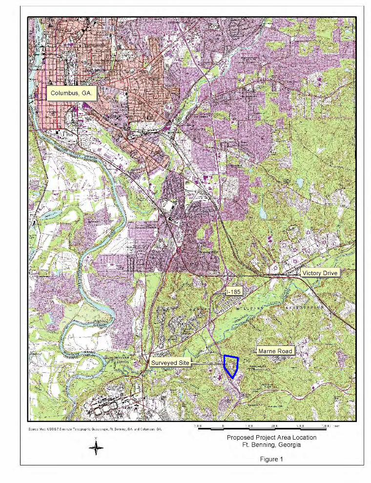


Parking
Building
Parking
26 Linear Feet of Stream Impact and0.013 Acres of Wetland Impact
The project footprintcovers 18.25 acres
200 0 200100 Feet
Figure 5Potential Wetland Impacts
Ft. Benning, Georgia
Legend
Impacted Wetland and Stream
Non-Impacted Jurisdictional Wetlands

Wetlands Jurisdictional Delineation Fort Benning, Georgia
14:1460.ES06.01_T1474
B-1
Attachment B
Dataforms


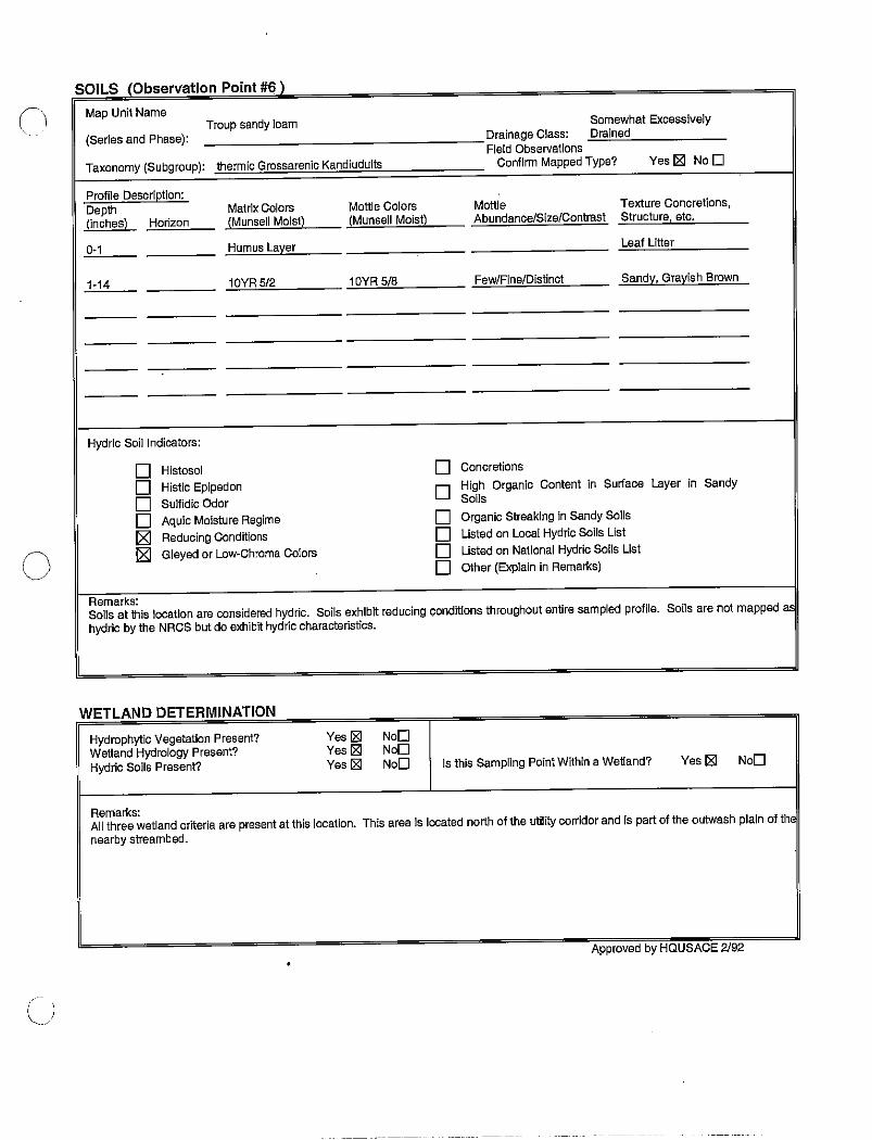
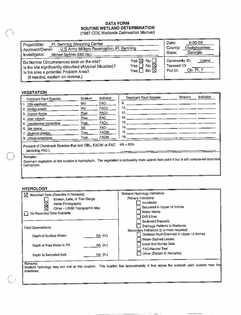


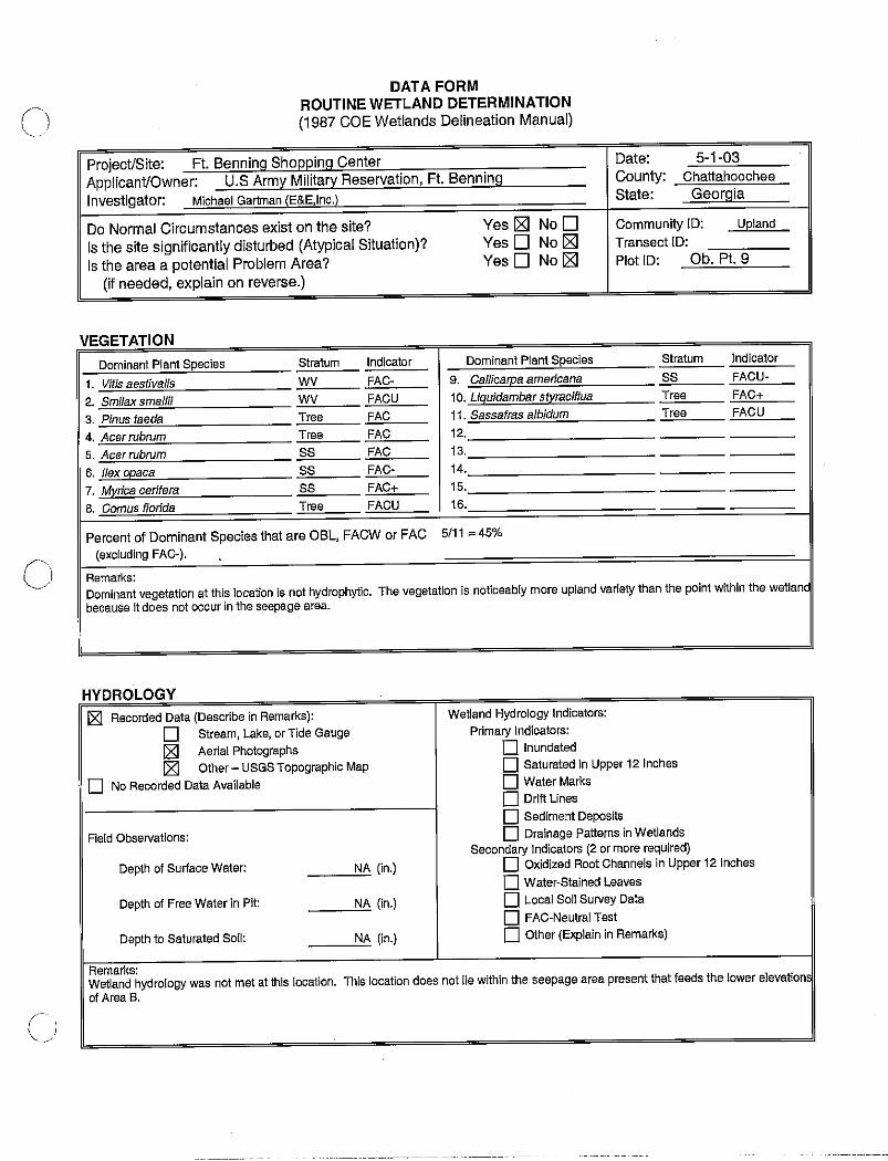

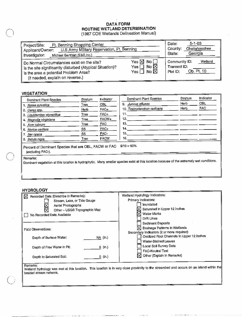


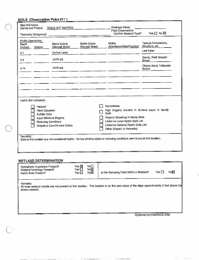


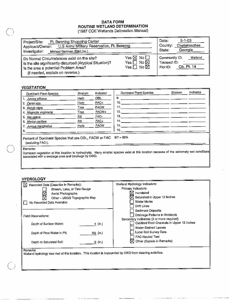


Wetlands Jurisdictional Delineation Fort Benning, Georgia
14:1460.ES06.01_T1474
C-1
Attachment C
Site Photographs

Photo1. Looking north at pine forested area on ridge plateau.
Photo 2. Looking west at utility line corridor from the ridge plateau on the surveyed area’s southern portion.

Photo 3. Looking north at ridge slopes and cleared areas.
Photo 4. Looking north at past inundated area behind weir of Area A.

Ph
oto
5. L
ooki
ng n
orth
at s
andy
stre
am b
ed a
nd a
ssoc
iate
d ou
twas
h w
etla
nd w
ithin
Are
a A
.
Ph
oto
6. L
ooki
ng e
ast a
t but
tress
ed tr
ees a
long
seep
age
area
w
ithin
Are
a B
.

Photo 7. Looking west at sandy stream bed and adjacent ridge slope in Area A.
Photo 8. Looking south at braided stream network in the upper extents of Area B

Ph
oto
9. L
ooki
ng n
orth
at h
ighl
y in
cise
d st
ream
cha
nnel
w
ithin
Are
a B
.
Ph
oto
10.
Look
ing
north
at c
lay
botto
m st
ream
bed
with
in
Are
a B
.
\\Talbdl1\publications\1400-1499\1460.ES06.01_T1474\July05 Final Draft\Final Draft Jul05.doc
B-1
Appendix B
Correspondence


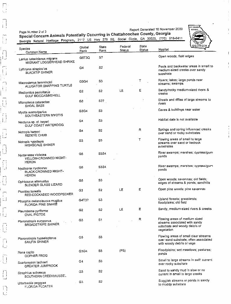
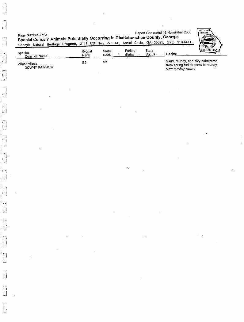
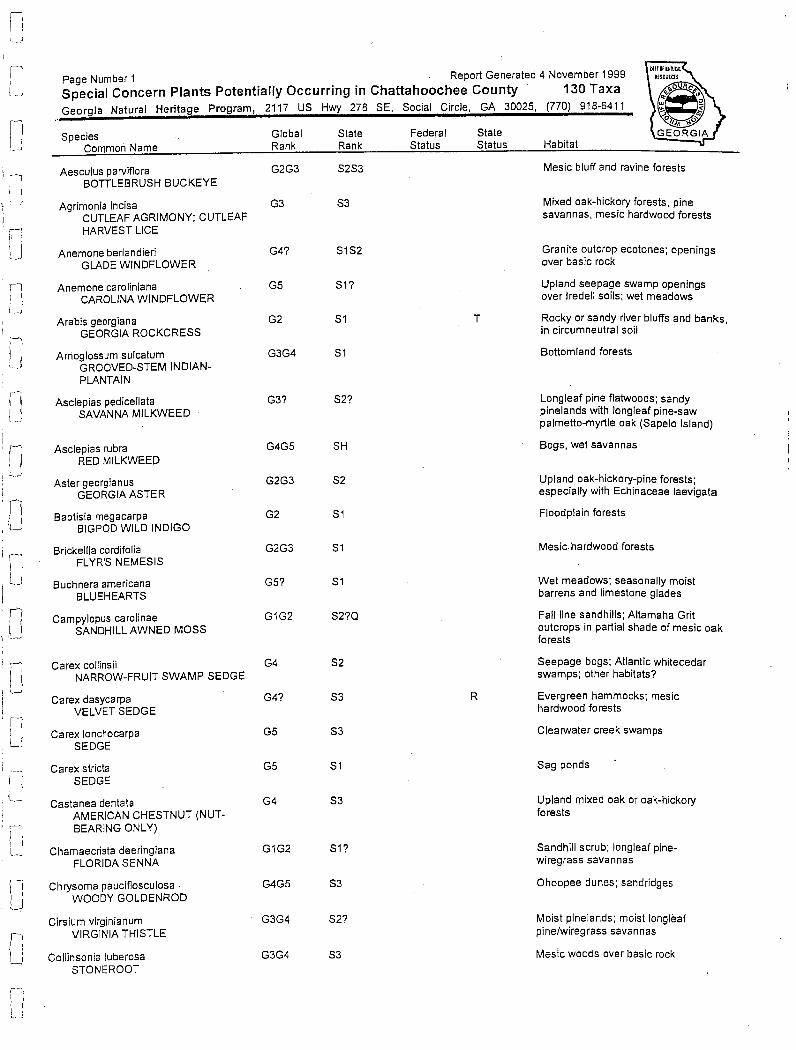
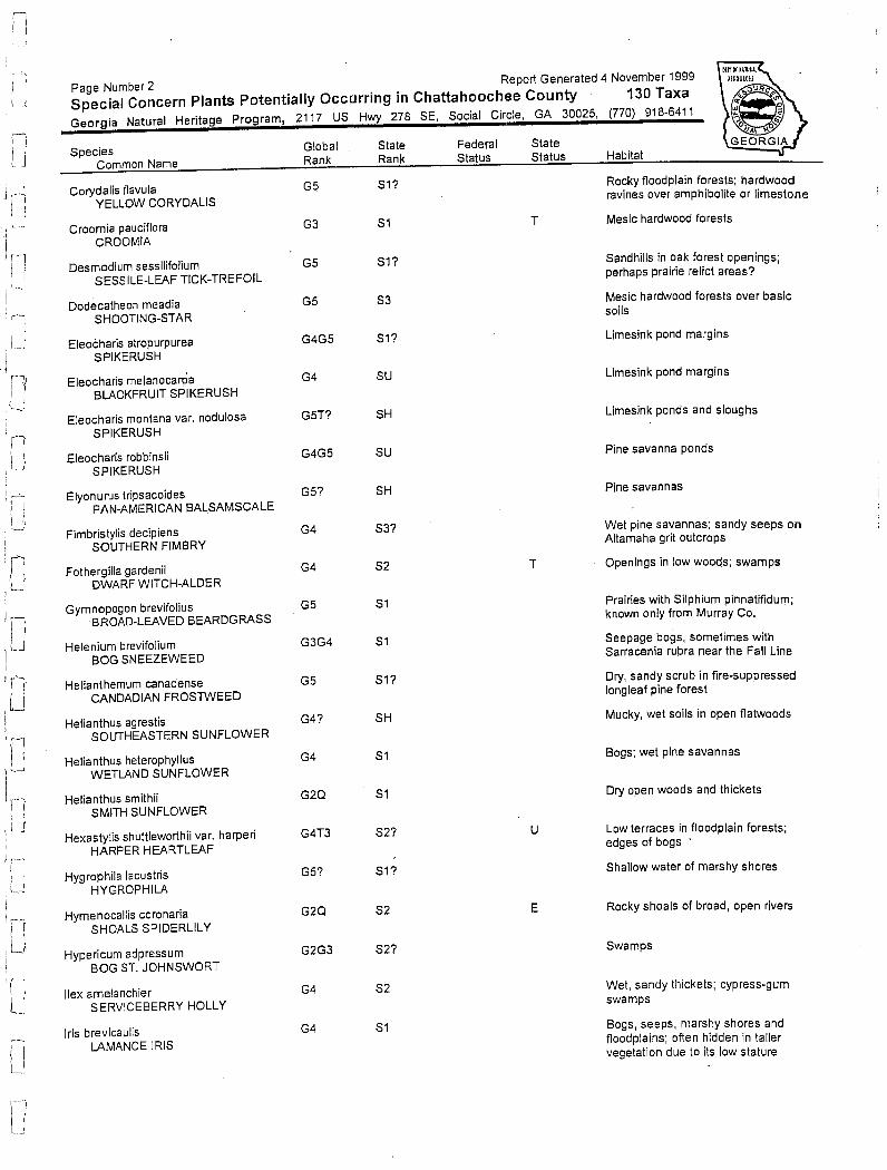
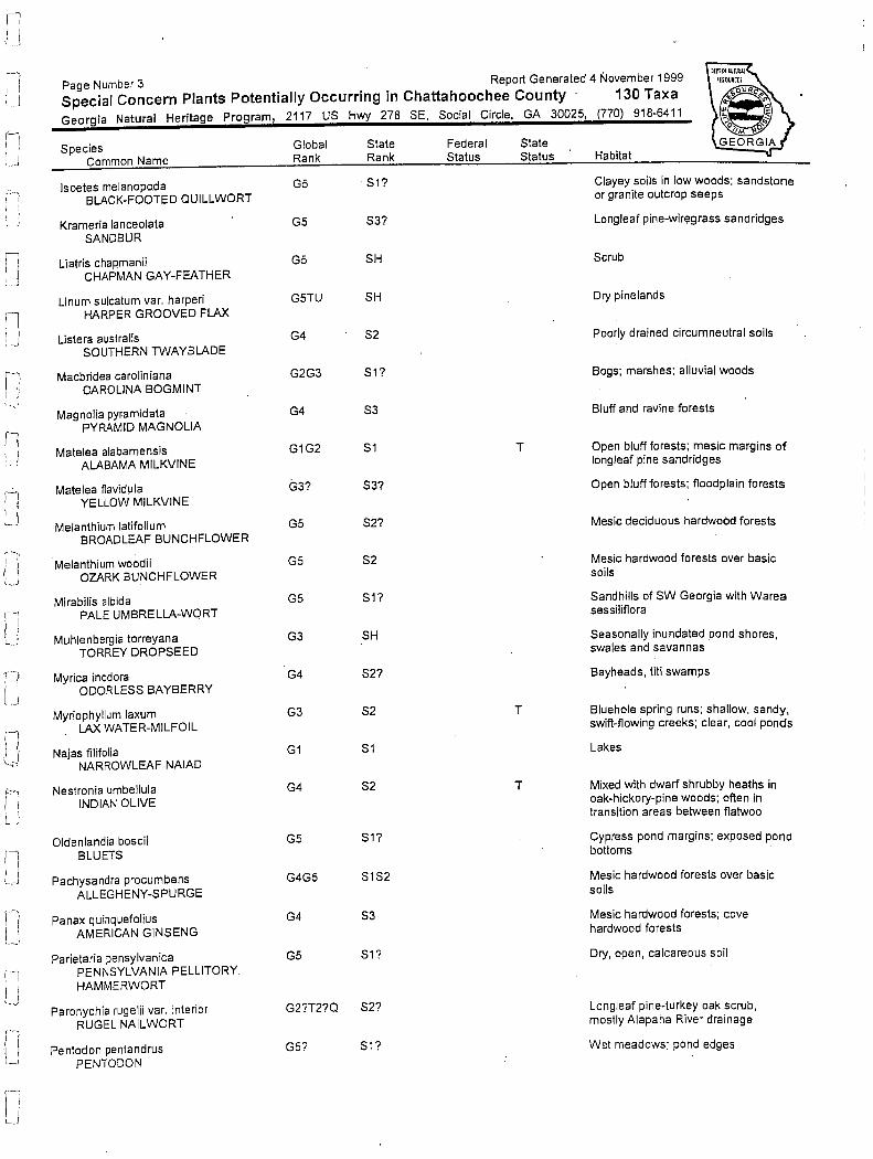


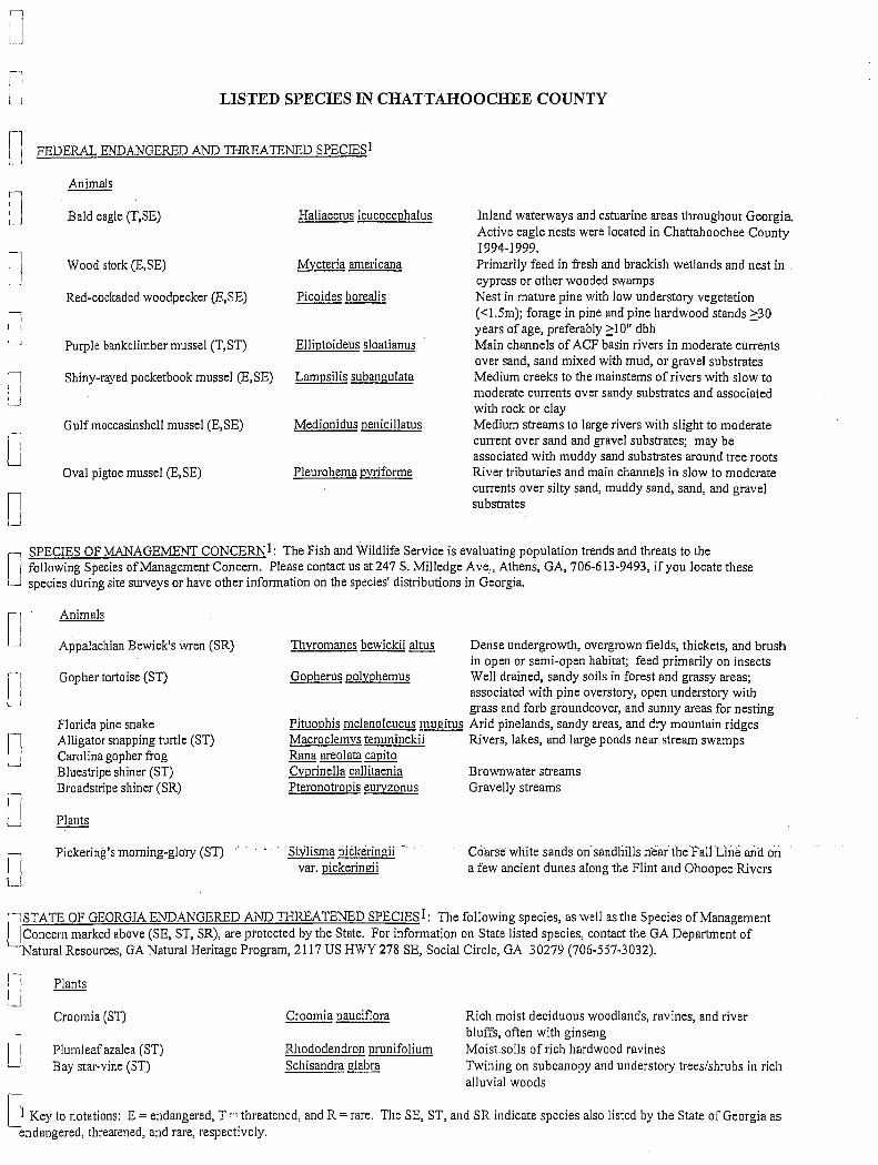
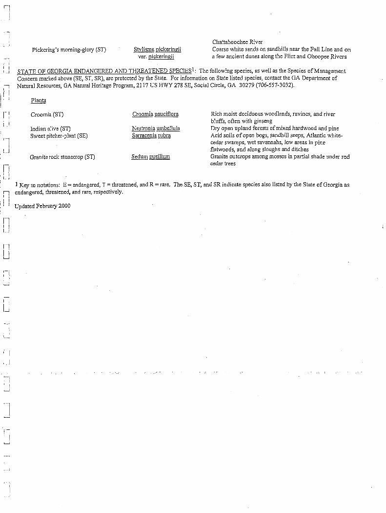


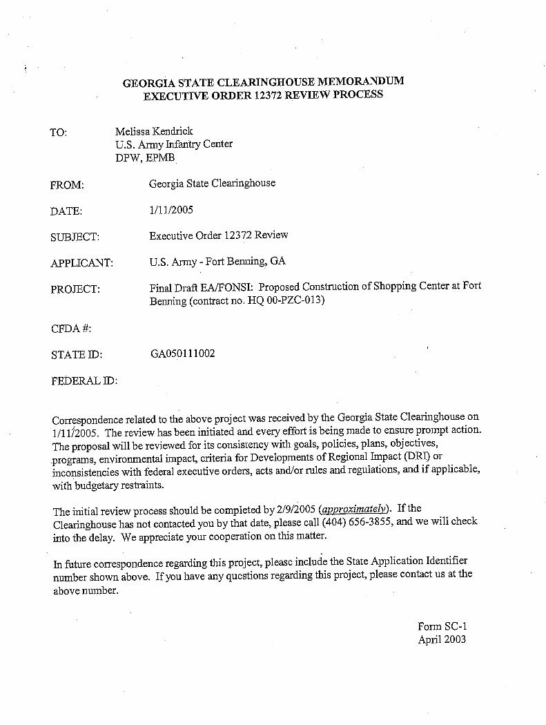


\\Talbdl1\publications\1400-1499\1460.ES06.01_T1474\July05 Final Draft\Final Draft Jul05.doc
C-1
Appendix C
USACE Nationwide Permit


\\Talbdl1\publications\1400-1499\1460.ES06.01_T1474\July05 Final Draft\Final Draft Jul05.doc
D-1
Appendix D
Air Quality Analysis Tables

New Construction (square feet) 218,000New Paved Area (acres) 14.2New Parking Spaces 1,101
Impact Area (acres) 22Total Building (sq ft) 218,000
Total paved areas (sq ft) 618,552Total Impact Area (Acres) 22
Construction: 20 months = 1.67 years250 work days per year
417.5 total days
Table D-1Fort Benning: Construction of new PX
Preferred Alternative (Alternative 7)
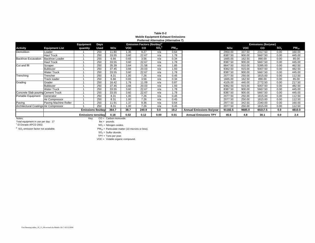
Equipment DaysActivity Equipment List quantity Used NOx VOC CO SO2
b PM10 NOx VOC CO SO2 PM10
Demolition Loader 1 250 11.80 1.35 9.27 n/a 0.64 2950.00 337.50 2317.50 0.00 160.00Haul Truck 1 250 33.55 3.60 22.67 n/a 1.78 8387.50 900.00 5667.50 0.00 445.00
Backhoe Excavation Backhoe Loader 1 250 6.66 0.65 3.56 n/a 0.34 1665.00 162.50 890.00 0.00 85.00Haul Truck 1 250 33.55 3.60 22.67 n/a 1.78 8387.50 900.00 5667.50 0.00 445.00
Cut and fill Scraper 1 250 35.39 3.64 21.58 n/a 1.85 8847.50 910.00 5395.00 0.00 462.50Bulldozer 1 250 37.45 3.66 20.03 n/a 1.93 9362.50 915.00 5007.50 0.00 482.50Water Truck 1 250 33.55 3.60 22.67 n/a 1.78 8387.50 900.00 5667.50 0.00 445.00
Trenching Trencher 1 250 8.31 1.00 7.26 n/a 0.45 2077.50 250.00 1815.00 0.00 112.50Track loader 1 250 6.66 0.65 3.56 n/a 0.34 1665.00 162.50 890.00 0.00 85.00
Grading Grader 1 250 16.42 1.76 11.09 n/a 0.87 4105.00 440.00 2772.50 0.00 217.50Bulldozer 1 250 37.45 3.66 20.03 n/a 1.93 9362.50 915.00 5007.50 0.00 482.50Water Truck 1 250 33.55 3.60 22.67 n/a 1.78 8387.50 900.00 5667.50 0.00 445.00
Concrete Slab pouring Cement Truck 1 250 33.55 3.60 22.67 n/a 1.78 8387.50 900.00 5667.50 0.00 445.00Portable Equipment Generator 1 250 8.31 1.00 7.26 n/a 0.45 2077.50 250.00 1815.00 0.00 112.50
Air Compressor 1 250 8.31 1.00 7.26 n/a 0.45 2077.50 250.00 1815.00 0.00 112.50Paving Paving Machine Roller 1 250 11.91 1.37 9.36 n/a 0.64 2977.50 342.50 2340.00 0.00 160.00Architectural Coatings Air Compressor 1 250 8.31 1.00 7.26 n/a 0.45 2077.50 250.00 1815.00 0.00 112.50
Emissions lbs/day 364.7 38.7 240.9 0.0 19.2 91182.5 9685.0 60217.5 0.0 4810.0
Emissions tons/day 0.18 0.02 0.12 0.00 0.01 45.6 4.8 30.1 0.0 2.4Notes: Key: CO = Carbon monoxide.Total equipment in use per day: 17 lbs = pounds.a El Dorado APCD 2002. NOx = Nitrogen oxides.b SO2 emission factor not available. PM10 = Particulate matter (10 microns or less).
SO2 = Sulfur dioxide.TPY = Tons per year.
VOC = Volatile organic compound.
Annual Emissions TPY
Table D-2Mobile Equipment Exhaust Emissions
Preferred Alternative (Alternative 7) Emission Factors (lbs/day)a Emissions (lbs/year)
Annual Emissions lbs/year
Fort Benning tables_10_11_04 revised.xls-Mobile Alt 7-10/12/2004
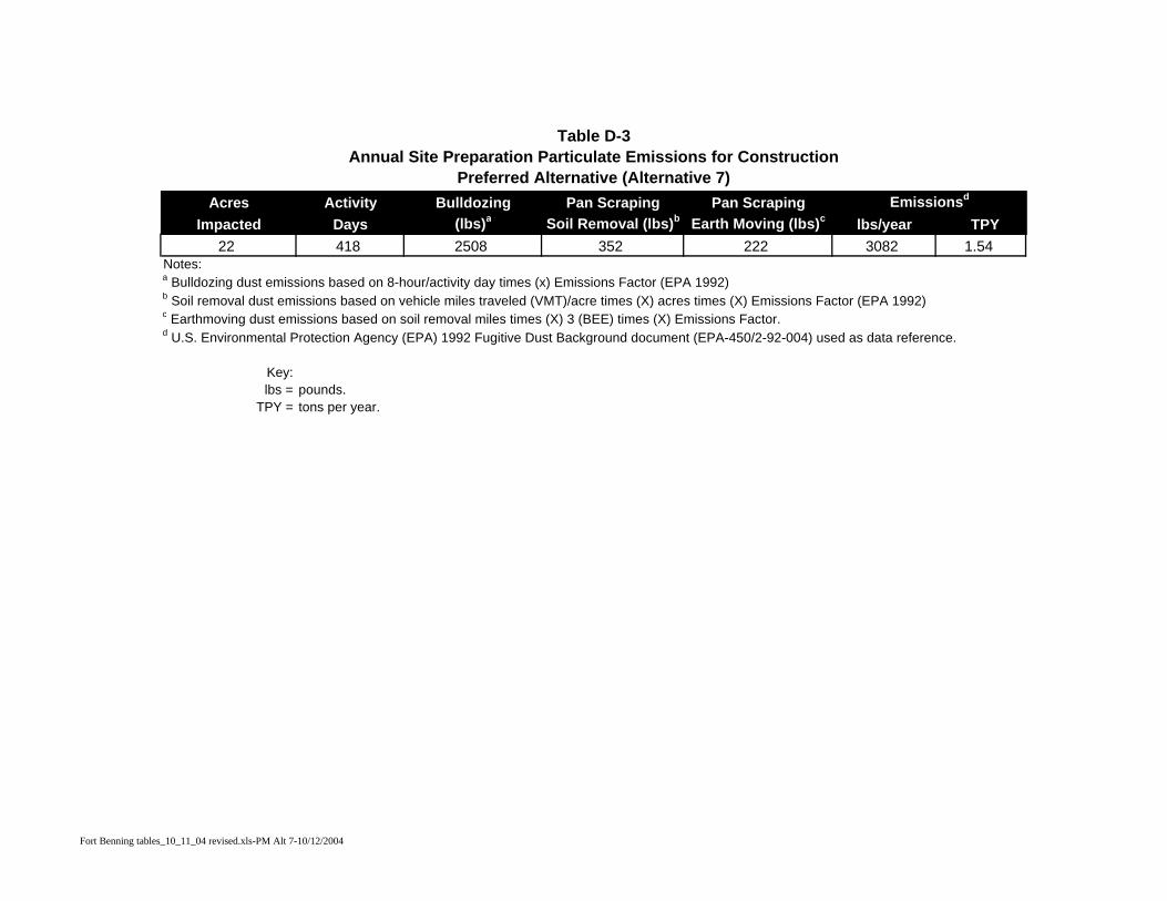
Table D-3Annual Site Preparation Particulate Emissions for Construction
Preferred Alternative (Alternative 7)Acres Activity Bulldozing Pan Scraping Pan Scraping Emissionsd
Impacted Days (lbs)a Soil Removal (lbs)b Earth Moving (lbs)c lbs/year TPY22 418 2508 352 222 3082 1.54
Notes:a Bulldozing dust emissions based on 8-hour/activity day times (x) Emissions Factor (EPA 1992)
c Earthmoving dust emissions based on soil removal miles times (X) 3 (BEE) times (X) Emissions Factor.
Key:lbs = pounds.
TPY = tons per year.
d U.S. Environmental Protection Agency (EPA) 1992 Fugitive Dust Background document (EPA-450/2-92-004) used as data reference.
b Soil removal dust emissions based on vehicle miles traveled (VMT)/acre times (X) acres times (X) Emissions Factor (EPA 1992)
Fort Benning tables_10_11_04 revised.xls-PM Alt 7-10/12/2004

Emission Factor EMISSIONS (lbs/acre/day) lbs/yearb TPY
Total 14.20 2.62 372.04 0.186Source: El Dorado APCD 2002.
Notes:a Emission Factor = 2.62 lbs per acre per day.b assumes paving will take place for 10 days.
Key:lbs = pounds.
TPY = tons per year.
Table D-4Annual Volatile Organic Compound (VOC) Emissions from Pavinga
Preferred Alternative (Alternative 7)
Acres Paved
Fort Benning tables_10_11_04 revised.xls-Paving Alt 7-10/12/2004

\\Talbdl1\publications\1400-1499\1460.ES06.01_T1474\July05 Final Draft\Final Draft Jul05.doc
E-1
Appendix E
Finding of No Significant Impact
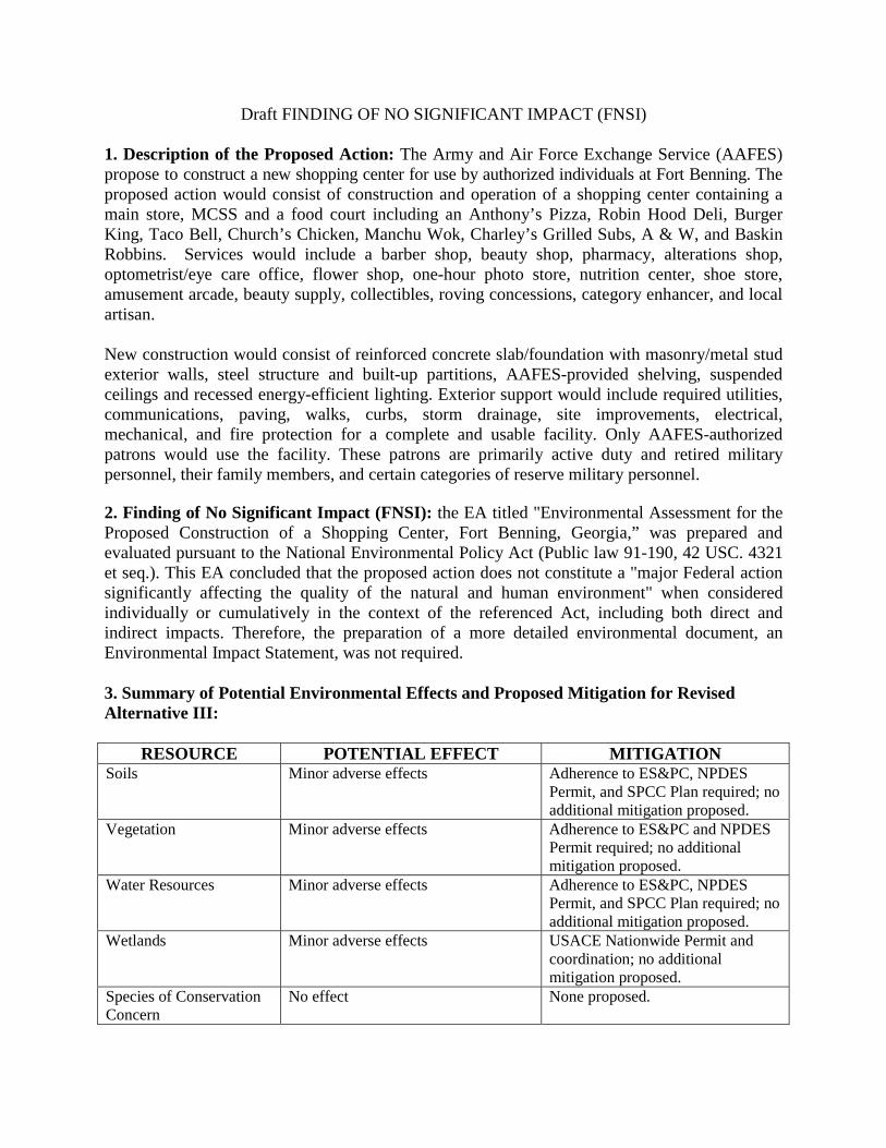
Draft FINDING OF NO SIGNIFICANT IMPACT (FNSI) 1. Description of the Proposed Action: The Army and Air Force Exchange Service (AAFES) propose to construct a new shopping center for use by authorized individuals at Fort Benning. The proposed action would consist of construction and operation of a shopping center containing a main store, MCSS and a food court including an Anthony’s Pizza, Robin Hood Deli, Burger King, Taco Bell, Church’s Chicken, Manchu Wok, Charley’s Grilled Subs, A & W, and Baskin Robbins. Services would include a barber shop, beauty shop, pharmacy, alterations shop, optometrist/eye care office, flower shop, one-hour photo store, nutrition center, shoe store, amusement arcade, beauty supply, collectibles, roving concessions, category enhancer, and local artisan. New construction would consist of reinforced concrete slab/foundation with masonry/metal stud exterior walls, steel structure and built-up partitions, AAFES-provided shelving, suspended ceilings and recessed energy-efficient lighting. Exterior support would include required utilities, communications, paving, walks, curbs, storm drainage, site improvements, electrical, mechanical, and fire protection for a complete and usable facility. Only AAFES-authorized patrons would use the facility. These patrons are primarily active duty and retired military personnel, their family members, and certain categories of reserve military personnel. 2. Finding of No Significant Impact (FNSI): the EA titled "Environmental Assessment for the Proposed Construction of a Shopping Center, Fort Benning, Georgia,” was prepared and evaluated pursuant to the National Environmental Policy Act (Public law 91-190, 42 USC. 4321 et seq.). This EA concluded that the proposed action does not constitute a "major Federal action significantly affecting the quality of the natural and human environment" when considered individually or cumulatively in the context of the referenced Act, including both direct and indirect impacts. Therefore, the preparation of a more detailed environmental document, an Environmental Impact Statement, was not required. 3. Summary of Potential Environmental Effects and Proposed Mitigation for Revised Alternative III:
RESOURCE POTENTIAL EFFECT MITIGATION Soils Minor adverse effects Adherence to ES&PC, NPDES
Permit, and SPCC Plan required; no additional mitigation proposed.
Vegetation Minor adverse effects Adherence to ES&PC and NPDES Permit required; no additional mitigation proposed.
Water Resources Minor adverse effects Adherence to ES&PC, NPDES Permit, and SPCC Plan required; no additional mitigation proposed.
Wetlands Minor adverse effects USACE Nationwide Permit and coordination; no additional mitigation proposed.
Species of Conservation Concern
No effect None proposed.
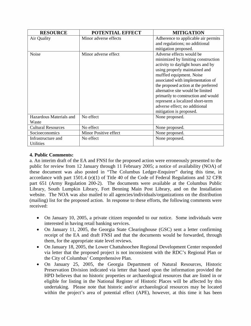
RESOURCE POTENTIAL EFFECT MITIGATION Air Quality Minor adverse effects Adherence to applicable air permits
and regulations; no additional mitigation proposed.
Noise Minor adverse effect Adverse effects would be minimized by limiting construction activity to daylight hours and by using properly maintained and muffled equipment. Noise associated with implementation of the proposed action at the preferred alternative site would be limited primarily to construction and would represent a localized short-term adverse effect; no additional mitigation is proposed.
Hazardous Materials and Waste
No effect None proposed.
Cultural Resources No effect None proposed. Socioeconomics Minor Positive effect None proposed. Infrastructure and Utilities
No effect None proposed.
4. Public Comments: a. An interim draft of the EA and FNSI for the proposed action were erroneously presented to the public for review from 12 January through 11 February 2005; a notice of availability (NOA) of these document was also posted in “The Columbus Ledger-Enquirer” during this time, in accordance with part 1501.4 (e)(1) of Title 40 of the Code of Federal Regulations and 32 CFR part 651 (Army Regulation 200-2). The documents were available at the Columbus Public Library, South Lumpkin Library, Fort Benning Main Post Library, and on the Installation website. The NOA was also mailed to all agencies/individuals/organizations on the distribution (mailing) list for the proposed action. In response to these efforts, the following comments were received:
• On January 10, 2005, a private citizen responded to our notice. Some individuals were interested in having retail banking services.
• On January 11, 2005, the Georgia State Clearinghouse (GSC) sent a letter confirming receipt of the EA and draft FNSI and that the documents would be forwarded, through them, for the appropriate state level reviews.
• On January 18, 2005, the Lower Chattahoochee Regional Development Center responded via letter that the proposed project is not inconsistent with the RDC’s Regional Plan or the City of Columbus’ Comprehensive Plan.
• On January 25, 2005, the Georgia Department of Natural Resources, Historic Preservation Division indicated via letter that based upon the information provided the HPD believes that no historic properties or archaeological resources that are listed in or eligible for listing in the National Register of Historic Places will be affected by this undertaking. Please note that historic and/or archaeological resources may be located within the project’s area of potential effect (APE), however, at this time it has been

determined that they would not be impacted by this project. Any changes to this project as proposed would require further review by our office for compliance with Section 106 process.
• An email comment was received from the U. S. Fish and Wildlife Service (USFWS) on 7
February 2005 requesting that any on-site habitat suitable for the endangered plant relict trillium (Trillium reliquum) be surveyed before construction is initiated, preferably during March 2005. Fort Benning and AAFES will work together to ensure that this survey is conducted, per USFWS request and during the desired period of time.
• On February 11, 2005, a letter from the Georgia Department of Natural Resources, Hazardous Waste Management Branch, indicated that based upon the information provided the project is considered to be consistent with those state or regional, goals, policies, plans, fiscal resources, criteria for developments of regional impact, environmental impacts, federal executive orders, acts and/or rules and regulations with which this organization is concerned.
The Corrected Final EA and draft FNSI are now available for public and stakeholder review and will be at the aforementioned libraries and on the Installation website (https://www-benning.army.mil/EMD/_program_mgt/legal/index.htm) starting 30 days from the first date of publication in “The Columbus Ledger Enquirer”. The NOA will also be re-distributed to all parties on the distribution (mailing) list and, when final, the resulting comments will be incorporated into the Final FNSI. b. Summary of additional comments: reserved until the completion of the 2nd public and stakeholder comment period. FINDING OF NO SIGNIFICANT IMPACT REVIEWED AND APPROVED BY: Date Ricardo R. Riera
Colonel, IN Garrison Commander

\\Talbdl1\publications\1400-1499\1460.ES06.01_T1474\July05 Final Draft\Final Draft Jul05.doc
F-1
Appendix F
Public Involvement Plan
F-3
Environmental Assessment for the Proposed Construction of a Shopping Center
Fort Benning, Georgia
Public and Stakeholder Involvement Plan (PIP) 14 December 2004
1. PURPOSE. 1.1 Need for Project. The proposed action is to better serve the needs of the military community through the improvement of shopping facilities on Fort Benning. The Post Exchange (PX) facility was built in 1973 and is part of the PX and commissary complex, which is 95,000 square feet and includes a gas station, parking lots, and other services. The PX and commissary complex facility is located on a site bounded by Marne Road to the north, I-185 to the west, Hamlet Creek to the north, and undeveloped property to the east and south (Figure 2-2). Currently, the Post Exchange (PX) is located in a confined space adjacent to the commissary, is highly congested, and too small to adequately serve the customer base. All AAFES food stores require substantial upgrades to meet the current retail standards AAFES requires at its newer facilities. Mechanical equipment is antiquated and the roof routinely leaks. To meet current AAFES retail standards, AAFES proposes to construct a new shopping center to solve the sizing, overcrowding, and maintenance problems, while maintaining easy access and locating the facility near the existing commissary and other associated services. 1.2 Need for Public and Stakeholder Involvement Plan. The construction and operation of the AAFES shopping center on Fort Benning involves legally mandated public comment and document review periods, as well as an opportunity to proactively identify and address any related community concerns. In addition to the general public, stakeholders must be identified and invited to participate, as well as regulator involvement as appropriate. This Plan presents a comprehensive means of satisfying legal requirements while enhancing community knowledge and participation in completing the proposed action. Throughout this Plan, “public” is used to broadly describe individuals that are in communities near the proposed project site or that may be interested or affected by the proposed action. “Stakeholder” is used to identify those entities that have an additional relationship to Fort Benning environmental resources or regulatory or governmental duties. Stakeholders include the Federally recognized American Indian Tribes associated with the Fort Benning area; Federal, state and local governmental agencies with regulatory authority over Fort Benning (e.g. United States Fish and Wildlife Service, and Georgia State Historic Preservation Office); and others. 1.2.1 Public involvement required by environmental laws and regulations.
1.2.1.1 National Environmental Policy Act (NEPA). The primary law that drives public involvement is the National Environmental Policy Act (NEPA). NEPA requires Federal agencies, such as the Army at Fort Benning, to prepare an environmental analysis of the proposed action and alternatives. Potential environmental impacts, both direct and indirect, are identified for the proposal and each alternative, and possible mitigation for any negative impacts is presented. Also, cumulative impacts (i.e. incremental impacts when considering other projects or actions in a region of affect) are identified as well as any resultant mitigation. Differing levels of NEPA analysis are available, however, because no significant affects are anticipated, an EA is being prepared.

F-4
The Council for Environmental Quality (CEQ) has NEPA oversight for the Federal government and has published regulations and guidance for the preparation of an EA. The Army supplements NEPA and the CEQ directions with an Army Regulation 200-2, Environmental Effects of Army Actions (AR 200-2) - current version effective 29 March 2002. AR 200-2 provides guidelines for the contents of an EA and the processes required for full environmental analysis with participation by public, stakeholders, and regulators. This Plan will not restate the provisions of AR 200-2, so attention to the specific requirements provided therein is required to fully comply with AR 200-2 and the Army’s guidance on public and stakeholder participation and scoping. NEPA requires opportunities for public participation, often called public scoping, during preparation of an EA. Public interaction is based on two-way communication that reflects the needs of the community, and may utilize such methods as notices, brochures, news releases, web page information, summaries, draft documents, public meetings, comments and/or other methods. Fort Benning should update the community at each significant phase or milestone of environmental planning. This Plan will address the optimal means of meeting the NEPA requirements at each stage. More details regarding the requirements for notices, documents reviews and comment periods are provided below. 1.2.1.2. Other Laws and Regulations. There are several other laws and regulations that require public notices and participation during the planning phases of a Federal project and some may be relevant to this proposed activity. Although NEPA may address some of the topics and issues in the EA, Fort Benning must still satisfy the requirements of these other laws and regulations. Additional requirements for public or stakeholder involvement, in this instance, may include Federal and state laws, regulations, or executive orders and Installation policies and guidelines addressing the following: Section 106 of the National Historic Preservation Act (Concurrence for affects to historic properties); a Section 404 of the Clean Water Act permitting wetland disturbance; NPDES construction and stormwater permits; and a Spill Prevention, Control, and Counter-Measure Plan (SPCC). Often additional planning documents will be required and available for public review and comment.
1.2.1.3. Integration of Information. Fort Benning will use information sharing, referencing, and other means to maximize the efficiency and affect of public and stakeholder involvement in the environmental planning process. Because NEPA is an umbrella-type process and produces a comprehensive document, other public participation opportunities (see section 1.2.2) will be woven into the existing framework for the NEPA public involvement. 1.2.2. Proactive Information Opportunity. AR 200-2 encourages continuous, two-way communication to enhance public and stakeholder participation. Fort Benning should take this opportunity to educate the public about Fort Benning’s mission, Fort Benning’s environmental stewardship, the construction of the proposed action, and any proposed mitigation that is important to the community. Various methods of communication with the public or more focused audiences are available, such as: mailings in the form of letters, brochures, information packets; electronic communications by email or website information; telephone calls and information lines; articles for Post and local newspapers; information presented via radio or television broadcasts; open houses or site visits; and meetings on an individual, small group, or large group format. Normally using a few communication devices that are focused and meet the needs of the community will be most effective. This Plan will introduce opportunities to inform the public at various phases or milestone events. 1.2.3. Goals of Plan. Fort Benning is committed to meeting the legal requirements and also takes measures for more meaningful communication and involvement of the public and stakeholders in the planning of the construction of the proposed AAFES shopping mall. Limitations in resources, personnel, and time impose constraints that necessitate an efficient and realistic Plan. This Plan must assist the planners and be realistic for implementation. Goals for this Plan include:

F-5
• Promote an understanding of public and stakeholder involvement requirements and opportunities for better resourcing and scheduling;
• Specify steps needed to meet legal responsibilities for comment opportunities of public members and stakeholders;
• List realistic time frames and responsible persons or offices for each step; • Coordinate activities to maximize the quality of the information, ensure the information relates to
planning actions in process, and incorporate any resultant feedback into future participation or planning processes;
• Incorporate opportunities to present information to better partner with the community; and • Keep PAO informed at all levels.
2. PLAN STRUCTURE. This Plan is presented chronologically, providing the anticipated steps, time frames and actions. Although this Plan is meant to serve as a foundation for public and stakeholder involvement, it may have to be adjusted to accommodate changes. Items in this Plan should be evaluated for suitability before engaging in the recommended actions. AR 200-2 divides the scoping process into three phases for simplification: the Preliminary Phase, the Public Interaction Phase, and the Final Phase. Although the majority of public and stakeholder involvement is conducted in the Public Interaction Phase, the other two stages encompass important steps to prepare for and respond to public and stakeholder involvement. This Plan will use the three phases to organize this Plan, although the phases often overlap.
3. PRELIMINARY PHASE. 3.1. Initial Internal Scoping. This is an internal Fort Benning action that is normally very informal and may result in limited amounts of documentation. Often proponents of the action start this internal scoping as a natural part of planning for the proposal, rather than as a conscious effort to conduct internal scoping. Internal scoping is a process of identifying project requirements, initial environmental concerns, and possibly explore options to address those concerns. Internal scoping is important because it commences the environmental analysis; however, internal scoping obviously is only a precursor to public and stakeholder involvement. It is important for the proponent and all those working with the proponent to keep in mind that the decisions regarding the project are not final and are just proposals. Until the process of environmental analysis and documenting a decision is complete, the proponent should be open to modifying the project, especially to reduce environmental impacts or to incorporate comments or mitigation. 3.1.1. Identify Proponent. Initially, the proponent(s) of the proposal is identified. Usually the proponent is the person or activity that has initiated the action, has initiated a funding request, and makes the important decisions or recommendations regarding the project. For the proposed construction and operation of the AAFES shopping mall, AAFES has been identified as the proponent. As the project planning progresses, other activities may be added to the list of proponents, but currently they should be considered stakeholders, affected or interested parties, or beneficiaries of the project. AAFES is preparing the environmental planning and documentation.
3.1.2. Coordinate with Environmental Planners. For actions that could have, i.e. the potential to have, a negative impact or a substantial positive impact on the environment, the proponent is required to coordinate with EMD. Early coordination is required for large or complex projects. Failure to coordinate early can lead to several problems, including failure to maintain a proper NEPA record, delay in project execution, extra expense from redesigns and incorporation of mitigation, plus other problems. Normally the proponent initiates coordination by submitting a completed Fort Benning Form 144-R to EMD to
F-6
determine what level of NEPA analysis is required; however the NEPA documentation for some proposals obviously requires more complex NEPA analysis and the internal scoping can begin with a kick-off meeting or other ways.
3.1.3. Document internal scoping efforts. NEPA compliance involves keeping records of alternatives explored, issues brought up, personnel involved, and other aspects of the internal scoping process. Preparing meeting minutes or notes or other evidence of internal scoping is helpful not only for maintaining an administrative file, but also to later recall information for environmental document preparation. Options that may have been considered informally in the internal scoping process may be a basis for an alternative to study formally in the EA. This internal scoping does not substitute for public scoping, but it is a necessary precursor.
3.1.4. Coordinate with Public Affairs Officers (PAO). The EMD and DPW will keep the Public Affairs Officer (PAO) at Fort Benning informed regarding environmental planning and scoping for the proposed AAFES construction project. It is the responsibility of the Fort Benning PAO to keep the Installation Management Agency (IMA), via the South East Regional Office (SERO), informed of this action and its progress. 3.1.5. Tentative List of Affected and Interested Parties (Mailing List). EMD maintains a NEPA mailing list consisting of individuals or entities that have shown interest in Fort Benning’s environmental studies or projects in the past. The mailing list also includes Federal, state and local government offices, Tribes, and anyone else requesting to be on the mailing list. This list should be thoroughly reviewed and adjusted for each NEPA action. Moving toward an electronic mailing database would be more efficient for many on the mailing list, and EMD should acquire email addresses for those who indicate a preference to receive email rather than traditional mail. At this time however, email cannot totally replace the numerous mailings that are required for notices associated with the SEA processing. For the proposed privatization process, Fort Benning has taken the basic Mailing List and adjusted it accordingly. A few names were also removed from the standard list to reflect an initial determination that those individuals or entities would not be interested or affected by the proposed privatization process. Part of the scoping process will be to continue requesting additional entries for the Mailing List through all stages and means of scoping. This List will be updated routinely to add individuals, organizations, entities and government agencies that may be affected by or interested in the proposed action. 4. PREPARATION OF THE EA AND FINDING OF NO SIGNIFICANT IMPACT (FNSI). 4.1. Involvement in Development of the EA. The EA is the environmental analysis document that is available for public review and comment in the NEPA process for this proposed action. While several partial drafts of the NEPA document may be routed for review at the Installation level, the first NEPA document to leave the installation for IMA/SERO and public review is the EA and draft FNSI. It should be the best attempt to inform the public and incorporate any scoping from the Preliminary Phase into the environmental analysis. 4.2. Preparation of the EA. 4.2.1. Drafting the NEPA Document. The EA should follow the general format in AR 200-2 although variations can be made as long as all required information and analysis are included. Environmental analysis in the EA requires reliable information regarding the project design. Developing the EA simultaneously with other environmental planning requirements is efficient and credible. 4.2.2. Gathering information. Much information can be obtained from existing sources, however additional surveys and/or analysis may be required. Coordination with the proponent, Fort Benning
F-7
stakeholders and external participants should be conducted early to ensure the information is correctly presented in the EA. 4.2.3. Coordinating with other environmental requirements. Several other environmental requirements will involve collecting of data, analyzing potential project impacts, and considering possible mitigation. Information obtained to satisfy other requirements would be incorporated into the EA, when available. Often only a summary of the related information is presented, with either a reference to the full document, placing the full document in an appendix, or incorporating by reference. If either referencing or incorporating another document, the full text of the document should be available for public review when the EA is made publicly available. If possible, the public involvement activities should be integrated to meet the requirements of NEPA and other requirements to present a complete picture of the project and potential environmental impacts to the public.
4.2.4. Coordinating with Others: The EA internal Army review should involve DPW, Master Planning, and the Office of the Staff Judge Advocate (OSJA). See AR 200-2 651.45(d)(2) for more information.
4.2.5. Cooperating Agencies. At this time, there are no cooperating agencies involved in the NEPA for the AAFES shopping mall construction.
5. THE FINAL PHASE. After the close of the timeframe for public comment on the EA and draft FNSI, the Final Phase begins. Comments are considered and any revisions must be incorporated, either by errata sheets for minor revisions or complete revision and production of a revised EA for more comprehensive changes. 5.1. Draft Finding of No Significant Impact (FNSI). No decision will be made until 30 days after the Draft EA is made available for public review and comment. The Draft FNSI includes the decision (which alternative is selected); a description of alternatives considered; explanation of all factors used in making the decision; and an account of avoidance and mitigation requirements. See AR 200-2, Section 651.35(c) for more information.
5.2. Mitigation and Monitoring. Mitigation measures and monitoring requirements will be identified in the EA and FNSI. Point of contact for requesting this information is the Fort Benning Public Affairs Office (PAO). Prepared By: Army and Air Force Exchange Service