Final Biological Assessment Report - ExxonMobil …€¦ · · 2015-08-211.0 PROJECT DESCRIPTION...
42
Transcript of Final Biological Assessment Report - ExxonMobil …€¦ · · 2015-08-211.0 PROJECT DESCRIPTION...


BIOLOGICAL ASSESSMENT
FOR
EXXONMOBIL CHEMICAL COMPANY
5000 Bayway Drive P.O. Box 4004
Baytown, Texas 77522-4004
FOR THE
BAYTOWN OLEFINS PLANT
ETHYLENE EXPANSION UNIT PROJECT
3525 Decker Drive Baytown, Texas 77520 Harris County, Texas
PREPARED BY:
RAVEN ENVIRONMENTAL SERVICES, INC. P.O. Box 6482
Huntsville, TX 77342 Phone: 1-877-291-0946
Fax: 1-936-291-0960
AND
SAGE ENVIRONMENTAL CONSULTING, L.P. 12727 Featherwood Drive, Suite 210
Houston, Texas 77034 Phone: 281-484-6200
Fax: 281-484-6201
May, 2013

2
TABLE OF CONTENTS EXECUTIVE SUMMARY ........................................................................................................... 3 1.0 PROJECT DESCRIPTION ................................................................................................... 4
1.1 Proposed action ................................................................................................................ 4 1.2 Alternatives Considered .................................................................................................... 4
2.0 METHODOLOGY ................................................................................................................. 4 2.1 Action Area Determination ................................................................................................ 4 2.2 Noise Effects Analysis ...................................................................................................... 7 2.3 Wastewater and Storm Water Analysis ............................................................................. 7 2.4 Listed Species Review .....................................................................................................11 2.5 TPW Database Review ....................................................................................................12 2.6 Literature Review .............................................................................................................12 2.7 Field Survey .....................................................................................................................12 2.8 Bird Occurrence Resources .............................................................................................13
3.0 SPECIES CONSIDERED ....................................................................................................13 4.0 EVALUATION OF EFFECTS ..............................................................................................14
4.1 Field Survey and Results .................................................................................................14 4.2 Species Analysis ..............................................................................................................15
4.2.1 Prairie Dawn – Endangered (FWS) ............................................................................15 4.2.2 Houston Toad – Endangered (TPW) ..........................................................................17 4.2.3 Red-cockaded Woodpecker – Endangered (TPW) ....................................................18 4.2.4 Whooping Crane – Endangered (TPW) .....................................................................19 4.2.5 Smalltooth Sawfish – Endangered (TPW) ..................................................................21 4.2.6 Red Wolf – Endangered (TPW) .................................................................................23 4.2.7 Four (4) Sea Turtles – 2 Endangered (TPW) and 2 Threatened (TPW) .....................23 4.2.8 Louisiana Black Bear – Threatened (TPW) ...............................................................26 4.2.9 Sprague’s Pipit – Candidate (TPW) ...........................................................................27
5.0 DETERMINATION OF EFFECTS SUMMARY ....................................................................29 6.0 LITERATURE CITED AND REFERENCES .........................................................................30 APPENDICES ...........................................................................................................................34
Exhibit A – Vicinity Map .........................................................................................................35 Exhibit B – USGS Quadrangle Map .......................................................................................36 Exhibit C – Color Aerial Map ..................................................................................................37 Exhibit D – List of Preparers ..................................................................................................38 Exhibit E – Project Area Photographs ....................................................................................39

3
EXECUTIVE SUMMARY The ExxonMobil Baytown Complex is located on approximately 3,400 acres along the Houston Ship Channel, about 20 miles east of downtown Houston. The Baytown Complex is comprised of the Baytown Refinery (BTRF), Baytown Chemical Plant (BTCP) and Baytown Olefins Plant (BOP). This proposed project to construct the BOP ethylene expansion is located in the Baytown area in the eastern portion of Harris County and is approximately 20 miles east of downtown Houston, Texas (straight-line). The project area is located in the extreme southeastern corner of the Highlands USGS 7.5’ Quadrangle (Quad). Specifically, the coordinate for the approximate center of the BOP proposed project area boundary will be Easting 305972 and Northing 3293690 (UTM, NAD 83, Zone 15 North, Meters). ExxonMobil Chemical Company (ExxonMobil) has submitted an application requesting authorization of greenhouse gas emissions to the U. S. Environmental Protection Agency Region 6 (EPA). ExxonMobil requested the services of Sage Environmental Consulting, L.P. (Sage) to assist in the permit process. Sage requested the services of Raven Environmental Services Inc. (Raven) to prepare a Biological Assessment (BA). Raven is an environmental management and consulting firm located in Huntsville, TX. At the request of EPA, a Biological Assessment was conducted and submitted December 14, 2012. This supplemental submittal addresses federally endangered, threatened, proposed and candidate species and their preferred habitat that are listed by Texas Parks and Wildlife Department (TPW) for Harris County, Texas. The objective of this BA is to determine the potential effects of EPA’s issuance of this permit on animal and plant species that are protected under the Endangered Species Act (ESA) and listed by the US Fish and Wildlife Service (FWS) and the National Oceanic and Atmospheric Administration National Marine Fisheries Service (NMFS) in Harris County, Texas. Raven conducted a literature review to locate published research concerning the potential effects of air pollution on wildlife generally and the species considered for evaluation in this BA specifically. Resources utilized include the World Wide Web, public libraries, the Raven reference library, and the personal environmental library of the author. Information and literature reviewed regarding the life histories and habitat requirements of the species for consideration include state and federal agency reports, management documents, peer-reviewed scientific literature, and online data provided by NatureServe, FWS, and TPW. Raven also contacted the following individuals to solicit feedback and information regarding the action area and the species for consideration: Mr. Arturo Vale (FWS Biologist, Houston, Texas) and Mr. Bob Gottfried (Administrator, Texas Natural Diversity Database, TPW, Austin, Texas). This BA is also based on the on-site field survey conducted by Raven, and the direct observations made of the project area and the larger action area. This BA was prepared in accordance with guidelines provided in 50 C.F.R. Part 402.12 (Consultation Procedures, Biological Assessments). As discussed in more detail in this assessment, based on a literature and data review, discussions with experts, the field survey, and the analysis of effects in this BA, no species listed as endangered, threatened, proposed or candidate by the FWS for Harris County Texas is known to occur within the action area, nor were the species themselves observed during the field survey. Accordingly, EPA’s issuance of the proposed project permit will have no effect on federally listed species.
4
1.0 PROJECT DESCRIPTION 1.1 Proposed action ExxonMobil Chemical Company (ExxonMobil) has submitted an application under the Environmental Protection Agency’s (EPA) Greenhouse Gas (GHG) Prevention of Significant Deterioration (PSD) Program requesting authorization of greenhouse gas emissions. Raven Environmental has been contracted by ExxonMobil to perform the review for the Baytown Olefins Plant Ethylene Expansion Unit Project and prepare the Biological Assessment (BA) to evaluate the potential effects to species listed as threatened and endangered under the Endangered Species Act (ESA). The ExxonMobil Baytown Complex includes the Baytown Refinery, Baytown Chemical Plant and Baytown Olefins Plant. This proposed project to construct the BOP ethylene expansion is located in the Baytown area in the eastern portion of Harris County and is approximately 20 miles east of downtown Houston, Texas (straight-line). The project area will be located in the northern part of the existing olefins plant and entirely on ExxonMobil plant property. The project area is located in the extreme southeastern corner of the Highlands USGS 7.5’ Quadrangle (Quad). Specifically, the coordinate for the approximate center of the BOP proposed project area boundary will be Easting 305972 and Northing 3293690 (UTM, NAD 83, Zone 15 North, Meters). For the project area location, please see the attached Exhibit A - Vicinity Map in the Appendix. Permanent project facilities include steam cracking furnaces, a recovery section for separation, and associated equipment such as cooling towers, utilities, flares, and storage. General site preparation and pre-construction activities associated with the project include temporary facilities (e.g., roads, offices, parking lots, laydown, utilities), dismantling, land clearing, equipment and piping relocations, and non-operating permanent facilities (e.g., fencing and paving). Feed and products for the project are managed solely in pipelines. For a map of the permanent project facilities, please see the attached Exhibits B and C in the Appendix. Process wastewater associated with the project receives final treatment in the Refinery under existing TPDES Permit No. WQ0000592000. Storm water is discharged through existing outfalls under BOP TPDES Permit No. WQ0002184000. Operation of the project will not increase traffic in the Houston Ship Channel. 1.2 Alternatives Considered There were no viable alternative locations for the project because it is an expansion of an existing manufacturing facility. The project’s purpose is to increase the capacity and output of specific products and requires infrastructure, support facilities and personnel that are already in place.
2.0 METHODOLOGY 2.1 Action Area Determination The “action area” for a BA as defined by 50 C.F.R. Part 402.02 means all areas to be affected directly or indirectly by the Federal action (EPA permit issuance) and not merely the immediate area involved in the action. Guidance from the EPA directed ExxonMobil to use the potential air dispersion of criteria pollutants resulting from the proposed project to evaluate the potential

5
impact on listed and candidate species. The results of this analysis were used to determine the boundary of the action area. Both primary and secondary National Ambient Air Quality Standards (NAAQS) were considered in defining the action area. As recommended by the FWS Consultation Handbook, the boundaries as defined for this action area will adequately address direct, indirect or interrelated/interdependent effects for listed and candidate species considered in this BA (see Section 3.0). To perform this analysis, ExxonMobil engaged Sage Environmental Consulting, LP (Sage). Sage utilized the EPA’s AERMOD model to predict the maximum ground level concentration values for criteria pollutants. This analysis resulted in a maximum significant impact area of up to 1.3 miles from the center of the proposed project. Based on CFR guidance, FWS guidance, and the Sage emissions analysis, Raven conservatively defined an action area that includes 1,276 acres. Primary and secondary NAAQS are shown in Table 1. ExxonMobil has submitted an air dispersion model to TCEQ to evaluate the proposed project impacts. The air dispersion modeling analysis was conducted in accordance with current TCEQ and EPA modeling procedures. Emissions of criteria pollutants from the project were evaluated to determine if they have a significant impact, as determined by each pollutant’s State NAAQSsignificant impact level (SIL). The modeled criteria pollutants include carbon monoxide (CO), nitrogen dioxide (NO2), particulate matter with an aerodynamic diameter of 10 microns or less (PM10), particulate matter with an aerodynamic diameter of 2.5 microns or less (PM2.5), and sulfur dioxide (SO2). Criteria pollutants were modeled using the EPA’s AERMOD model to obtain off-property concentrations for comparison with the appropriate State NAAQS thresholds. The modeled concentration from each pollutant was compared to the applicableSIL. If the modeled concentration did not result in a significant impact (i.e., the modeled concentration is less than theSIL, then the demonstration was complete. If the modeled concentration exceeded theSIL, then further analysis was used to demonstrate compliance with the NAAQS. Table 1 lists the criteria pollutants and averaging periods modeled for comparison to the applicable SIL concentrations. The distance from the center of the existing BOP to where the SIL is exceeded is noted in miles in the table. Additional modeling was conducted to demonstrate compliance with the State NAAQS for 24-Hour PM2.5. Pollutants that do not have a distance listed did not result in a significant impact (i.e., the modeled concentration is less than the SIL) beyond the property line of the existing BOP.

6
Table 1. Constituents evaluated in NAAQS analysis and distances from BOP where no exceedances are expected.
Criteria Pollutant Averaging
Period SIL
(ug/m3)
Distance from Center of BOP where no SIL Exceedance is
Expected (miles)
Carbon Monoxide (CO) 1-Hour 2,000 -- 8-Hour 500 --
Nitrogen Dioxide (NO2) 1-Hour 7.5 -- Annual 1.0 --
Particulates (PM10) 24-Hour 5.0 --
Particulates (PM2.5) 24-Hour 1.2 1.3 Annual 0.3 --
Sulfur Dioxide (SO2)
1-Hour 7.8 -- 3-Hour 25.0 -- 24-Hour 5.0 -- Annual 1.0 --
Based on the results from the State NAAQS analysis, the maximum significant impact area of the proposed emission sources should extend less than 1.3 miles from the center of BOP. New linear facilities for the project, such as transmission lines for power, pipelines or road easements, will not extend beyond the boundaries of this action area. The potential for airborne pollutants to directly affect aquatic habitats in the action area and any subsequent indirect downstream effects was also considered. The potential effects of airborne pollutants on aquatic resources include both acidification and eutrophication. Acidification is the deposition of air pollutants in acid form or that have acid-forming properties. Eutrophication is the over-enrichment of nutrients into an aquatic system. In general, acidification and eutrophication can result in a set of cascading adverse effects that can reduce dissolved oxygen within an aquatic ecosystem that impairs and disrupts normal aquatic processes and functions. No large open surface waters such as bays or estuaries are located within the proposed project action area. Aquatic features within the action area are confined to intermittently flowing creeks, improved industrial canals, and small impoundments or industrial ponds. The only natural water feature within the action area is the West Fork Goose Creek that drains into the Goose Creek watershed. In addition, improved canals and outfalls are in the action area.
For the proposed project, given the infrequency of the predicted exposure of a concentration greater than the SIL to the aquatic features (e.g. streams, canals, ponds) within the action area, it is reasonable to assume the emissions resulting from this project will not affect the water quality of the streams and canals within the action area. No pH impact is expected. Since no direct or short-term effects are expected to aquatic features within the action area, no adverse downstream effects to larger watersheds including the Houston Ship Channel are expected. An additional 800 feet of new underground pipe inside the Baytown project action area on adjacent property will also be added. This 800 feet pipeline is located within the action area boundaries of the Baytown project site. This area is industrial with a history of intensive land use, soil disturbance and vegetation management (primarily mowing). The new pipe easements provide no habitat for any species listed as threatened, endangered or as candidates for listing.

7
2.2 Noise Effects Analysis The possibility of direct and indirect effects from noise disturbance occurs during the construction phase of the project, followed by the normal operation of the facility. It is important to provide some point of reference when discussing sound. The decibel (dB) is a logarithmic unit that cannot be added and subtracted like ordinary numbers. An increase of 3dB is a doubling of the "strength" of the sound (e.g. an increase of 10dB means the sound is 10 times as loud). As a reference, normal human conversation at a range of three (3) feet is in the 60-65 decibel (dB) range, and 85 dBA is the level at which hearing protection is required during 12-hour shifts. The construction period for the proposed project is three years. General site preparation and construction associated with the project will increase noise levels across the plant. During this period, activities will include the use of all or some of the following equipment: bulldozer, dump truck, grader, scraper, loader, backhoe, mobile crane, concrete mixer, and concrete pump. The average noise level range for each type of equipment at a distance of 50 feet for industrial construction is between 91 (truck) and 79 (loader) while the average dBA at 50 feet for all 9 pieces of equipment listed is 84.22 dBA (USEPA, 1971, Noise From Construction Equipment…). After construction is complete, the project will operate normally. During normal operation, the project will emit noise at a relative ambient or steady level, normally between 10-20 dBA. Noise levels associated with operation of the project will be far below 85 dBA by the time they reach the action area boundary. Given this low level of ambient noise and regardless of the ESA listing status of a given species, it is reasonable to assume that noise alone produced by construction and operation of the project would not displace any species of plants or animals in the action area or preclude the ability of new species to occupy habitat in the action area. 2.3 Wastewater and Storm Water Analysis The proposed project will produce process wastewater and cooling tower blowdown water. It will collect first-flush storm water runoff and post first-flush storm water. All water streams are similar in quality to streams that are already produced at the Baytown Refinery (BTRF). Process Wastewater: Process wastewater will routed to a new wastewater stripper at BOP. The stripper will remove materials and return them to the process. Stripped wastewater will be routed to the BTRF wastewater system for additional treatment including oil/water separation and biological treatment. Treated wastewater will be ultimately discharged under TPDES Permit No. WQ0000592000 and no effect on our ability to consistently operate within our TPDES permit limits is anticipated. Cooling tower blowdown will be combined with BTRF wastewater at a sewer trunk junction. This water will also be routed to the existing BTRF wastewater system for additional treatment including oil/water separation and biological treatment. Treated wastewater will be ultimately discharged under TPDES Permit No. WQ0000592000 and no effect on our ability to consistently operate within our TPDES permit limits is anticipated. First-flush storm water: First-flush storm water will be collected. This water will be combined with BTRF wastewater at a sewer trunk junction. The water will be routed to the existing BTRF wastewater system for additional treatment including oil/water separation and biological treatment. Treated wastewater will be ultimately discharged under TPDES Permit No.
8
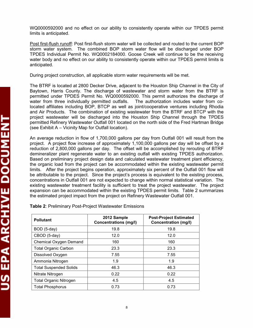
WQ0000592000 and no effect on our ability to consistently operate within our TPDES permit limits is anticipated. Post first-flush runoff: Post first-flush storm water will be collected and routed to the current BOP storm water system. The combined BOP storm water flow will be discharged under BOP TPDES Individual Permit No. WQ0002184000. Goose Creek will continue to be the receiving water body and no effect on our ability to consistently operate within our TPDES permit limits is anticipated. During project construction, all applicable storm water requirements will be met. The BTRF is located at 2800 Decker Drive, adjacent to the Houston Ship Channel in the City of Baytown, Harris County. The discharge of wastewater and storm water from the BTRF is permitted under TPDES Permit No. WQ0000592000. This permit authorizes the discharge of water from three individually permitted outfalls. The authorization includes water from co-located affiliates including BOP, BTCP as well as joint/cooperative ventures including Rhodia and Air Products. The combination of existing wastewater from the BTRF and BTCP with the project wastewater will be discharged into the Houston Ship Channel through the TPDES permitted Refinery Wastewater Outfall 001 located on the north side of the Fred Hartman Bridge (see Exhibit A – Vicinity Map for Outfall location). An average reduction in flow of 1,700,000 gallons per day from Outfall 001 will result from the project. A project flow increase of approximately 1,100,000 gallons per day will be offset by a reduction of 2,800,000 gallons per day. The offset will be accomplished by rerouting of BTRF demineralizer plant regenerate water to an existing outfall with existing TPDES authorization. Based on preliminary project design data and calculated wastewater treatment plant efficiency, the organic load from the project can be accommodated within the existing wastewater permit limits. After the project begins operation, approximately six percent of the Outfall 001 flow will be attributable to the project. Since the project’s process is equivalent to the existing process, concentrations in Outfall 001 are not expected to change within normal statistical variation. The existing wastewater treatment facility is sufficient to treat the project wastewater. The project expansion can be accommodated within the existing TPDES permit limits. Table 2 summarizes the estimated project impact from the project on Refinery Wastewater Outfall 001. Table 2: Preliminary Post-Project Wastewater Emissions
Pollutant 2012 Sample Concentrations (mg/l)
Post-Project Estimated Concentration (mg/l)
BOD (5-day) 19.8 19.8 CBOD (5-day) 12.0 12.0 Chemical Oxygen Demand 160 160 Total Organic Carbon 23.3 23.3 Dissolved Oxygen 7.55 7.55 Ammonia Nitrogen 1.9 1.9 Total Suspended Solids 46.3 46.3 Nitrate Nitrogen 0.22 0.22 Total Organic Nitrogen 4.5 4.5 Total Phosphorus 0.73 0.73

9
Oil and Grease ˂ 2.4 ˂ 2.4 Total Residual Chlorine 0.06 0.06 Total Dissolved Solids 1900 1900 Sulfate 1405 1405 Chloride 283 283 Fluoride 0.3 0.3 Fecal Coliform 15 15 Temperature (°F) 75.4 75.4 pH (Standard Units; min/max) 7.5 7.5
2012 Sample
Concentrations (µg/l) Post-Project Estimated
Concentration (µg/l) Total Aluminum 102.5 102.5 Total Antimony 6.6* 6.6* Total Arsenic 6.2* 6.2* Total Barium 110 110 Total Beryllium ˂ 1.3 ˂ 1.3 Total Cadmium 0.66 0.66 Total Chromium ˂ 10 ˂ 10 Trivalent Chromium ˂ 10 ˂ 10 Hexavalent Chromium ˂ 10 ˂ 10 Total Copper 3.3* 3.3* Cyanide 4.1* 4.1* Total Lead ˂ 2.9 ˂ 2.9 Total Mercury 0.028* 0.028* Total Nickel 12.5 12.5 Total Selenium 16.8 16.8 Total Silver ˂ 1.3 ˂ 1.3 Total Thallium 5.9 5.9 Total Zinc 12.4 12.4 Benzene ˂ 2.1 ˂ 2.1 Benzidene ˂ 3.9 ˂ 3.9 Benzo(a)anthracene ˂ 0.71 ˂ 0.71 Benzo(a)pyrene ˂ 0.64 ˂ 0.64 Carbon Tetrachloride ˂ 2.8 ˂ 2.8 Chlorobenzene ˂ 1.5 ˂ 1.5 Chloroform ˂ 2.7 ˂ 2.7 Chrysene ˂ 0.81 ˂ 0.81 Cresols ˂ 1.3 ˂ 1.3 Dibromochloromethane ˂ 1.7 ˂ 1.7 1,2-Dibromoethane ˂ 1.1 ˂ 1.1

10
1,4-Dichlorobenzene ˂ 1.3 ˂ 1.3 1,2-Dichloroethane ˂ 2.4 ˂ 2.4 1,1-Dichloroethylene ˂ 2.2 ˂ 2.2 Fluoride 420 420 Hexachlorobenzene ˂ 1.1 ˂ 1.1 Hexachlorobutadiene ˂ 1.4 ˂ 1.4 Hexachloroethane ˂ 1.6 ˂ 1.6 Methyl Ethyl Ketone ˂ 2.1 ˂ 2.1 Nitrobenzene ˂ 1.8 ˂ 1.8 n-Nitrosodiethylamine ˂ 1.8 ˂ 1.8 n-Nitroso-di-n-Butylamine ˂ 1.4 ˂ 1.4 PCB's, Total ˂ 0.060 ˂ 0.060 Pentachlorobenzene ˂ 0.65 ˂ 0.65 Pentachlorophenol ˂ 1.1 ˂ 1.1 Phenanthrene ˂ 0.97 ˂ 0.97 Pyridine ˂ 1.9 ˂ 1.9 1,2,4,5-Tetrachlorobenzene ˂ 1.2 ˂ 1.2 Tetrachloroethylene ˂ 1.7 ˂ 1.7 Trichloroethylene ˂ 2.1 ˂ 2.1 1,1,1-Trichloroethane ˂ 2.6 ˂ 2.6 2,4,5-Trichlorophenol ˂ 1.5 ˂ 1.5 TTHM (Total Trihalmethanes) ˂ 0.63 ˂ 0.63
Vinyl Chloride ˂ 2.5 ˂ 2.5 * Estimated value.
The TCEQ Surface Water Monitoring Information System database was used to collect water quality data from monitoring station 13340 (Black Duck Bay; Segment 2428). This station represents the closest station to Outfall 001 and the project. Data from this station is provided in Table 3. Given the treatment standards already discussed and the project discharge will be within TPDES permit limits, the existing wastewater treatment facility is sufficient to treat the project wastewater. Project wastewater will not significantly change values for this monitoring station.

11
Table 3. TCEQ Water Quality Monitoring Data Summary for Monitoring Station 13340 (Watershed Black Duck Bay; Segment 2428).
Parameter Sample Concentrations and Values*
Estimated Post-project Sample Concentrations
and Values Temperature (°F) 72.7 ≤72.7 Dissolved Oxygen 10.6 ≤10.6 pH 8.5 ≤8.5 Specific Conductance 19606 ≤19606 Salinity 11.78 ≤11.78 Secchi Transparency 0.41 ≤0.41 Enterococci 59 ≤59 Ammonia-N 0.07 ≤0.07 Orthophosphate-P 0.14 ≤0.14 Nitrate-N 0.17 ≤0.17 Total Phosphorus 0.28 ≤0.28 Chlorophyll a 26.8 ≤26.8 Total Organic Carbon 8.3 ≤8.3 Salts/Total 11731 ≤11731 Total Suspended Solids 22 ≤22 Total Hardness 2255.2 ≤2255.2 *TCEQ sampling period 07/22/2004 through 04/20/2010.
Authorized discharges meeting BTRF permit requirements include process wastewater, storm water, groundwater, cooling tower blowdown, steam condensate and regenerate from a demineralizer plant. The wastewater system includes oil/water separation and biological treatment. The TCEQ Executive Director has reviewed this permit action for consistency with the Texas Coastal Management Program (CMP) goals and policies in accordance with the regulations of the Coastal Coordination Council, and has determined that the action is consistent with the applicable CMP goals and policies. No additional BTRF authorization, such as changes to permit limits, is anticipated to accommodate water from BOP’s proposed project. No effect on our ability to consistently operate within the BTRF TPDES permit limits is anticipated. Since there will be no significant increase in concentration and since treatment standards will occur as described above for the project, it is reasonable to assume that the discharge resulting from this project will not affect the receiving water and the water quality of the streams, canals and bays within or near the action area. Since no direct or short-term effects are expected for aquatic features within or near the action area, no adverse downstream effects to larger watersheds including the Houston Ship Channel are expected. 2.4 Listed Species Review Federally-listed threatened and endangered species are provided by county through the FWS website (http://www.fws.gov/southwest/es/ES_Lists_Main.cfm) and the NMFS (http://www.nmfs.noaa.gov/pr/species/esa/) . A review of this website identified only one FWS species listed for Harris County; the endangered prairie dawn (Hymenoxys texana). Mr. Arturo Vale (FWS Biologist, Houston, Texas), was contacted by Raven via phone and email and asked whether the FWS required or recommended that any additional species be considered for
12
effects in this BA. He responded that the species list provided by this website would be adequate for an evaluation of effects for this project. However, EPA recommends as a conservative measure that federally-listed species and candidate species included on the TPW endangered species website for Harris County (http://www.tpwd.state.tx.us/landwater/land/maps/gis/ris/endangered_species/) should also be considered in this BA. 2.5 TPW Database Review Raven reviewed two TPW resources for historic occurrence records for proposed, endangered, or threatened species (as defined by ESA, Section 4). The first source is the TPW online webpage mentioned above for “Rare, Threatened, and Endangered Species of Texas by County”. The second source is the TPW Texas Natural Diversity Database (TXNDD), which is a Geographic Information System (GIS) integrated Oracle database that stores spatial and tabular information for threatened and endangered species; rare species of concern; rare natural vegetation communities; and other rare natural resources. Raven received TXNDD GIS shapefiles and historic element occurrence records for the action area USGS quadrangle (the Highlands Quad) and also the adjacent, eight contiguous surrounding USGS Quads – an area that encompasses approximately 560 square miles for all 9 Quads combined. The GIS shapefiles were projected in ArcView and the element occurrence records were reviewed. It was determined that, according to TXNDD, there are no federally listed endangered, threatened, proposed or candidate species within this 560 square mile area (and the proposed project action area) and that the nearest known record for a sensitive (non-regulatory) plant community is more than 3 miles southeast of the project area. 2.6 Literature Review Raven conducted a literature review to locate published research that is focused on the potential effects of air pollution on wildlife, plants and birds. Resources utilized include the World Wide Web, public libraries, the Raven reference library, and the personal environmental library of the author. A few abstracts describing research aimed at determining the effects of air pollutants on both free-ranging and captive birds were found on the web. However, these studies were/are being conducted in Europe and are focused mostly on heavy metals and acid rain pollution emitted from several coal-powered electric plants and one copper smelter. One study by The Nature Conservancy was reviewed that generally describes the effects of 4 pollutants on 8 different imperiled plant communities or forest types in the northeastern U.S. None of the literature that we reviewed was directly applicable in determining the direct, indirect, and cumulative effects to prairie dawn specifically or its preferred habitat and associated plant community. 2.7 Field Survey The field surveys for this BA were conducted on June 28, 2012 and October 30, 2012 by Mr. Ross Carrie (Raven). The action area was again surveyed on April 16, 2013 by Mr. Eric Keith (Raven) to specifically examine the site during the time period when Prairie dawn (Hymenoxys texana) normally has abundant above-ground vegetative growth and is in flower. Mr. Keith has extensive experience with the field identification of Prairie Dawn that includes a published range extension in the technical literature for the species. The project area lies entirely within the existing plant and on ExxonMobil property. The majority of the proposed project area is either currently developed for industrial use or has some recent history of soil disturbance or

13
vegetation management. These developed or disturbed areas would provide approximately 16.6 acres for development of the project area. Specifically, these areas would include the flare, furnaces and recovery section of the plant. A forested tract on the northern portion of the project area would provide approximately 9.7 acres for development of utilities and offsites for the proposed project. The remaining 1,276 acres within the action area was remotely sensed for habitat type and quality by examining 2008-2009 Texas Orthoimagery Program (TOP), color infrared, 0.5 meter (cell size) aerial images projected in ESRI® ArcMap™ 10.0, a geographic information software computer program. By using direct observation (pedestrian survey), indirect observation and remote sensing techniques, the entire action area was assessed for habitat type and quality to the greatest degree that is legally possible. Local public roads, including Decker Drive and connected municipal roads, were also driven to generally observe and assess the vegetation communities and habitat conditions at the landscape level. 2.8 Bird Occurrence Resources There are three public domain resources for bird census information that were utilized in this BA to assist in analyzing the potential effects to the bird species listed by TPW for Harris County. All three are citizen-volunteer bird census counts that occur annually across the U.S. and that have online and downloadable data available. Only the data that was collected within the a reasonable distance of this action area was used. The bird census surveys are:
1. Christmas Bird Count (CBC). 2. North American Breeding Bird Survey (BBS). 3. Ebird (http://ebird.org)
The CBC is managed and sponsored by the National Audubon Society and the nearest CBC bird count circle is the Houston-Baytown (TXHO) circle. Each CBC circle has a 15 mile diameter and the center-point of the TXHO circle is located approximately 3 miles east of the project area. This action area lies entirely within the TXHO circle. The BBS is managed and sponsored by the U.S. Geological Survey, Patuxent Wildlife Research Center. The nearest BBS routes to the action area are the Stowell route (BBS number 83021) located 20 miles east and the Winnie route (BBS number 83020) located 23 miles southeast. Both routes were established in 1967 and surveys have been completed almost every year since establishment. Ebird is the public-domain online resource managed and sponsored by the Cornell Lab of Ornithology and the National Audubon Society. This resource was queried for bird observations in all of Harris County. These three resources were accessed online at the following URL addresses:
1. CBC: http://audubon2.org/cbchist/count_table.html 2. BBS: http://www.pwrc.usgs.gov/BBS/results/routemaps/routeAssignMap.cfm# 3. Ebird: http://ebird.org
3.0 SPECIES CONSIDERED Species considered for this BA are those that are federally listed as endangered, threatened, proposed and candidate species as determined under authority of the ESA by the FWS and

14
listed for Harris County, Texas on the Region 2, FWS website accessed February 14, 2013 The FWS has determined that the following species are threatened or endangered in this county:
Prairie Dawn (Hymenoxys texana): Endangered At the request of EPA, this BA also considers federally listed endangered, threatened, proposed and candidate species that are not listed by FWS for Harris County, Texas, but that are listed by TPW for Harris County, Texas. The TPW website was accessed February 14, 2013, and the TPW species listed for Harris County (without FWS duplication) include:
Houston Toad (Anaxyrus houstonensis): Endangered Red-cockaded Woodpecker (Picoides borealis): Endangered Whooping Crane (Grus Americana): Endangered Smalltooth Sawfish (Pristis pectinata): Endangered Red Wolf (Canis rufus): Endangered Kemp’s Ridley Sea Turtle (Lepidochelys kempii): Endangered Leatherback Sea Turtle (Dermochelys coriacea): Endangered Green Sea Turtle (Chelonia mydas): Threatened Loggerhead Sea Turtle (Caretta caretta): Threatened Louisiana Black Bear (Ursus americanus luteolus): Threatened Sprague’s Pipit (Anthus spragueii): Candidate
The 1,276-acre action area was reviewed for the presence of these species and their habitats. The review process first determined whether suitable habitat was potentially present. The potential for occurrence was based on direct observation during the field survey. Additional information sources included NatureServe, FWS, TPW / TNNDD element occurrence records, literature listed in the reference section and GIS shapefiles. The most current survey information and location/occurrence status was also obtained from various sources.
4.0 EVALUATION OF EFFECTS 4.1 Field Survey and Results The initial field survey was conducted on June 28, 2012 with an additional field survey occurring on October 30, 2012, both conducted by Mr. Ross Carrie (Raven). The action area was assessed by Mr. Carrie by directly observing habitat conditions within the project area that will be temporarily or permanently disturbed and altered. The action area was again surveyed on April 16, 2013 by Mr. Eric Keith (Raven) to specifically examine the site during the time period when Prairie dawn (Hymenoxys texana) normally has abundant above-ground vegetative growth and is in flower. Mr. Keith has extensive experience with the field identification of Prairie Dawn that includes a published range extension in the technical literature for the species. Also, by utilizing GIS software to examine high resolution aerial imagery, Raven personnel remotely-sensed (surveyed) the approximate 1,276 acre action area. Local public roads were also driven to assess and validate vegetation communities and habitat conditions that could be observed from these roads. The action area is located within the Western Gulf Coastal Plain, as described in Level III Ecoregions of the United States, and in the Northern Humid Gulf Coastal Prairies as Level IV. The Gulf Coastal Plain is a low, flat plain extending more than 360 miles long and 50 to 100 miles wide along the Texas and Louisiana coastline. Rivers that drain from the north-west

15
highlands of Texas to the Gulf of Mexico deposited sediments on coastal plain during the Pleistocene and Holocene Epochs. Being a transition area between the continent and the ocean, the coastal plain is home to a myriad of people, plants wildlife, and fish. All these living organisms depend on streams that bisect this region to some extent for the supply of fresh water, sediments, and nutrients to maintain their lives and productivity. A large quantity of water, nonetheless, has been diverted to municipal, agricultural and industrial uses as human population increases and economic development rises. The Northern Humid Gulf Coastal Prairies lies within the gently sloping coastal plain. The original vegetation was mostly grasslands with a few clusters of oaks (Quercus spp.), known as oak mottes or maritime woodlands. Little bluestem (Schizachyrium scoparium), yellow indiangrass (Sorghastrum nutans), brownseed paspalum (Paspalum plicatulum), gulf muhly (Muhlenbergia capillaris), and switchgrass (Panicum virgatum) were the dominant grassland species. Almost all of the coastal prairies have been converted to cropland, rangeland, pasture, or urban land uses. The exotic and non-native tallowtree (Triadica sebifera) and Chinese privet (Ligustrum chinensis) have invaded large areas in this region. Some loblolly pine (Pinus taeda) occurs in the northern part of the region. Soils are mostly fine-textured: clay, clay loam, or sandy clay loam. Annual precipitation varies from 37 inches in the southwest portion to 58 inches in the northeast. (USEPA, Omernick, 1987). Direct observation of the action area during the field survey confirms the invasion of exotic species. The northern vegetated portion of the project area is almost entirely covered with tallowtree, intermixed with numerous chinaberry trees and sugarberry (Celtis laevigata), with a groundcover comprised almost entirely of another non-native invasive species (NNIS); Japanese honeysuckle (Lonicera japonica). The previously described excavated ponds are variously bordered by black willow (Salix nigra), wax myrtle (Morella spp.), cattail (Typha spp.) and palmetto (Sabal spp.). The larger action area, as observed by driving public roads, was comprised primarily of heavy industry and commercial land uses with scattered areas of small woodlands - all of which appear to be invaded primarily by tallowtree, as well as other NNIS tree, shrub and grass species. Grass species directly observed included mostly bermudagrass (Cynodon spp.) and bahiagrass (Paspalum notatum), with almost no native grassland species observed. No species for consideration was directly observed during the survey. For a map of the proposed action overlaid on a USGS Topographic quadrangle, please see the attached Exhibit B – USGS Quadrangle Map. For a map of the proposed action overlaid on a color infrared aerial image, please see the attached Exhibit C – Color Aerial Map. 4.2 Species Analysis 4.2.1 Prairie Dawn – Endangered (FWS) 4.2.1.1 Environmental Baseline Prairie dawn (Hymenoxys texana), also known as Texas prairie dawn-flower, was first collected in 1889 and was considered extinct until its rediscovery in 1981. Prairie dawn was listed by the FWS as endangered in 1986 and remains without critical habitat. The global and state ranks are: G2 and S2. A member of the sunflower family (Asteraceae), prairie dawn is a single-stemmed or branching annual reaching a height of up to 6 inches. The basal leaves are spoon-shaped, with entire or

16
toothed margins. The stem leaves are alternate, narrow with parallel sides, with no or few teeth on the margins. Prairie dawn flowers are present from March through early April. They are yellow and are actually a cluster of flowers less than one half inch long. The seeds are cone-shaped and mature from April through May. This species is known from Fort Bend, Harris, and Trinity counties, and possibly La Salle County. High potential habitat for prairie dawn is sparsely vegetated areas of fine-sandy soil in open grasslands in poorly drained depressions and saline swales, including the periphery of low “pimple” mounds. Pimple mounds are small (usually 10 to 60 feet in diameter) low (usually less than 12 inches high) mounds of sandier soil than the surrounding flat areas. The bare spots are usually wet to moist during the cool months of winter and early spring, but they dry out to almost desert-like conditions during the hot summer. This habitat type is often referred to as a “slick”. Pimple mounds occur in the upper Gulf Prairies and are of unknown origin. The soil itself often covered with blue-green algae. It may occur on disturbed soils, if the soil structure remains relatively intact. The upper 7 inches of the soils are poorly drained and are powdery when dry and sticky and soft when wet. The discrete and specific nature of Prairie Dawn microhabitat is generally not distinguishable on county-wide soils maps. Threats to this species include highway development, urban expansion, herbicide use, conversion of lands to agriculture and improved pastures, and the invasion of brush and other woody species. Known prairie dawn populations were originally thought to be limited to the west and northwestern portions of Harris County. Additional sites have been discovered in the last twenty years, including the northeast and southeast parts of Harris County and far eastern Trinity County. Most populations occur on private land. Harris County is currently undergoing tremendous and rapid urban development. All areas of natural habitat are rapidly disappearing. Recovery efforts include a large population of prairie dawn that is informally protected by the U.S. Army Corps of Engineers within Addicks Reservoir due west of Houston. The largest known population is located on a 100-acre tract of land owned by the Katy Prairie Conservancy in northwest Harris County. This tract was originally purchased by Conservancy to protect remnant coastal prairie. Another large population was also discovered in southeast Harris County. Much of this population will likely be lost to highway development, but a 24-acre tract will be set aside by Harris County and managed as a conservation area. 4.2.1.2 Available Inventories Recent inventories in or near the project area and action area for this species are available from the TXNDD records. The nearest TXNDD prairie dawn occurrence to the proposed project is located over ten miles (straight-line) to the southeast (Data acquired from TXNDD on July 2, 2012). A ground survey of the project area and accessible portions of the action area was conducted by personnel from Raven on June 28 and October 30, 2012 to determine whether suitable prairie dawn habitat was present in the project area or the larger action area. The action area was again surveyed on April 16, 2013 by Mr. Eric Keith (Raven) to specifically examine the site during the time period when Prairie dawn (Hymenoxys texana) normally has abundant above-ground vegetative growth and is in flower. Mr. Keith has extensive experience with the field identification of Prairie Dawn that includes a published range extension in the technical literature for the species. No prairie dawn plants were observed during any surveys. No high potential
17
habitat was observed such as slicks, pimple mounds or commonly associated plant communities. 4.2.1.3 Determination of Effects As described previously, the project area and large portions of the action area have a long history of industrial use, intensive vegetation management and habitat disturbance in general that would not be conducive to supporting suitable habitat for prairie dawn. As discussed, high potential habitat for prairie dawn is sparsely vegetated areas of fine-sandy soil in open grasslands in poorly drained depressions, saline swales, and pimple (mima) mounds that are relatively barren of vegetation. These bare spots are usually wet to moist during the cool months of winter and early spring, but they dry out to almost desert-like conditions during the hot summer. No prairie dawn plants or its very specific habitat and soil type were detected during surveys of the project and action area for this BA, or during other past inventories in this geographic area, so it is unlikely that prairie dawn exists within or near the action area. Given the lack of sightings and that there is no suitable habitat in the action area, the construction and operation of the project will have no effect on prairie dawn. 4.2.2 Houston Toad – Endangered (TPW) 4.2.2.1 Environmental Baseline The Houston toad (Anaxyrus houstonensis) requires loose, deep sands at least 40 inches in depth, supporting woodland savannah, and still or flowing waters for breeding. The largest population of Houston toads exists in Bastrop County, Texas. The Houston toad is 2 to 3.5 inches long. Its general coloration varies from light brown to gray or purplish gray, sometimes with green patches. The pale undersides often have small, dark spots. Males have a dark throat, which appears bluish when distended. The Houston toad lives primarily on land. The toads burrow into the sand for protection from cold weather in the winter (hibernation) and hot, dry conditions in the summer (aestivation). Plants that are often present in Houston toad habitat include loblolly pine, post oak (Q. stellata), bluejack oak (Q. incana), yaupon holly (Ilex vomitoria), and little bluestem. The Houston toad is a year-round resident where found, although its presence can most easily be detected during the breeding season, February through March, when males may be heard calling. Males usually call in or near shallow water or from small mounds of soil or grass surrounded by water. Habitat loss and alteration are the most serious threats facing the Houston toad. Alteration of ephemeral and permanent natural wetlands for urban and agricultural uses eliminates breeding sites. Draining a wetland, or converting an ephemeral wetland to a permanent pond, can eventually cause the Houston toad to decline or be eliminated entirely. Conversion to permanent water makes them more vulnerable to predation by snakes, fish, and other predators and increases competition and hybridization with closely related species. 4.2.2.2 Available Inventories The TPW “Five-year Status Review: Houston Toad; Final Report, As Required by The Endangered Species Program, Texas” was published in March 2010. The list of counties from which Houston toads have been historically reported by authorities includes Austin, Bastrop, Burleson, Colorado, Fort Bend, Harris, Lavaca, Lee, Leon, Liberty, Milam, and Robertson. The last Houston toads reported from Liberty County were in the 1950s, Fort Bend in the 1960s, Harris in the mid-1970s, Burleson in 1990, and Lavaca in 1991. Based on the most recent

18
surveys and research, TPW now considers the Houston toad to be likely extirpated in Lavaca, Fort Bend, Harris, and Liberty Counties. 4.2.2.3 Determination of Effects As described previously, the project area and large portions of the action area have a long history of industrial use, intensive vegetation management and habitat disturbance that have eliminated the native herbaceous vegetation, specifically bunchgrass species, that Houston Toad normally prefer. In addition, this intensive land use environment has produced a compacted and/or heavily disturbed soil profile in most areas that is likely no longer suitable as burrowing habitat for toads. TPW now considers the Houston toad to be likely extirpated in Harris County with the last record of occurrence being more than 35 years old (from the mid-1970s). During the Raven field survey, no Houston toads or its specific habitat was observed within the action area. Given the lack of sightings and that there is no suitable habitat in the action area, the construction and operation of the project will have no effect on the Houston toad. 4.2.3 Red-cockaded Woodpecker – Endangered (TPW) 4.2.3.1 Environmental Baseline The red-cockaded woodpecker (Picoides borealis) is associated with open, mature pine forests that it uses for nesting, foraging, and cavity excavation (Jackson 1971). FWS estimates the current red-cockaded woodpecker (RCW) population in the Southeast U.S. is less than 3 percent of the original population. The loss of old-growth pine forest in the southeastern United States, particularly the open park-like longleaf uplands, has greatly contributed to the decline of the RCW. Large-scale timber harvesting during the latter 1800’s and early 1900’s in conjunction with the conversion of many forested areas to agriculture were the primary factors responsible for the decline in RCW habitat. More recently, urbanization of woodlands, short-rotation timber management, and especially suppression of natural fire regimes have intensified the decline of suitable RCW habitat. The FWS formally listed red-cockaded woodpeckers as endangered in 1973. Despite this status, RCW numbers continued to decline until the mid-1990’s. New management techniques that increase cavity availability (restrictor plates and artificial cavity inserts) and improvements in habitat management (midstory control) have displayed encouraging results in sustaining and/or increasing populations in the last 10 to 15 years. The RCW has a high potential to occur in mature (80+ years-old), upland pine forests with an open canopy, sparse mid-story, and a grassy, herbaceous groundcover layer normally resulting from a history of periodic fire. The RCW has a lower potential to occur in mature pine stands on more mesic sites, with denser canopies, an increased hardwood component and forests with little to no herbaceous groundcover species. 4.2.3.2 Available Inventories The CBC and BBS resources have no (0) records of RCW having ever been observed in their respective areas of coverage. Ebird lists one record of RCW in Harris County over 100 years ago. No TPW element occurrence records for RCW are documented within the TXNDD sample

19
area (9 Quadrangles equaling ~560 square miles). The nearest known active RCW group is located 43 miles northwest of the project area within the William Goodrich Jones State Forest (Jones SF), which is managed and operated by the Texas Forest Service, and is located just north of The Woodlands, Texas. A ground survey of the action area and surrounding area was conducted by personnel from Raven on June 28 and October 30, 2012 to determine whether suitable habitat was present in the 1,276-acre action area, and to determine whether RCW could be present. No RCW were detected during this survey. Suitable RCW habitat is absent from the action area. The single timber stand or forested area within the action area is a dense, 30-acre stand, consisting primarily of young hardwood species and non-native plant species and is completely lacking the open, grassy, park-like, older-age class pine forest habitat required by this species. 4.2.3.3 Determination of Effects The action area and surrounding area, which is comprised of heavy industry and dense urban development includes no open mature (greater than 60 years old) pine forest habitat that is considered suitable for the RCW. The few small forest stands that are in the action area that include either individual pine trees or patches of pine forest habitat possess dense understory, midstory and overstory layers of various hardwood species that make the stand structure unsuitable as nesting and foraging habitat for RCWs. The relatively poor habitat conditions in these few stands is likely the result of long-term fire suppression on the landscape concurrent with the industrialization of the area.s noted above, there are no RCW occurrence records in the TXNDD database within the action area or the 560 square mile data acquisition area. There are no records of RCW observations in any of the CBC, BBS or Ebird surveys, and no individual RCW were observed during the field survey conducted by Raven. Given no suitable habitat is in or near the action area and there are no records of RCW observations in the action area, the construction and operation of the project will have no effect on RCW. 4.2.4 Whooping Crane – Endangered (TPW) 4.2.4.1 Environmental Baseline The whooping crane (Grus Americana) occurs only in North America and is North America’s tallest bird, with males approaching 5 feet. The species can have a wingspan of 7.5 feet and can weigh 17 pounds. The body length averages about 52 inches. The whooping crane’s adult plumage is snowy white except for black primaries, black or grayish alula (specialized feathers attached to the upper leading end of the wing), sparse black bristly feathers on the carmine crown and malar region (side of the head from the bill to the angle of the jaw), and a dark gray-black wedge-shaped patch on the nape. Immature whooping cranes are cinnamon brown. Whooping cranes are omnivorous and feed on insects, frogs, rodents and vegetation in shallow, seasonally and semi-permanently flooded wetlands. Whooping cranes are a long-lived species. Current estimates suggest a maximum longevity in the wild of at least 30 years. There is only one self-sustaining wild population – the Aransas Wood Buffalo National Park population, which nests in the area of Wood Buffalo National Park in Canada, and winters in coastal marshes surrounding Aransas National Wildlife Refuge in Texas. Whooping cranes migrate throughout the central portion of the state during October-November and again in April.

20
Spring migration from the Texas Gulf Coast begins from March 25 to April 15 with the last birds leaving by April 15. The whooping crane’s migration to its nesting grounds in Canada can be rapid, requiring as few as 10 to 11 days to cover 2400 miles with very few stops. Its southward migration in the fall can require up to 50 days: a two-day flight from breeding range to staging area in Saskatchewan where birds remain one to five weeks on grainfields and wetlands, and then a rapid one-week trip across U.S. prairies states ending at wintering range on Aransas National Wildlife Refuge. It is a diurnal migrant, rarely continuing after dark. During migration, it makes regular stops to feed and rest using a variety of habitats for foraging and roosting away from human activity. Flight during migration is generally characterized as infrequent flapping and rapid, high-altitude flight (600 – 1800 meters) with limited wing movement. During migration, cranes use the more energy-efficient passage that results from repetitive sequences of spiraling upward in thermal updrafts followed by long, slow, declining glide. Habitat used for roosting and feeding during migration includes croplands and palustrine (freshwater inland, shallow) wetlands. Migratory stopovers are well-defined for cranes, existing in the southern Saskatchewan, Nebraska, Kansas and Oklahoma. The closest migratory stopover to the action area is the Salt Plains National Wildlife Refuge in Alfalfa County, Oklahoma. In general, the field habitats in the action area do not provide adequate feeding and stopover habitat for migrant cranes because they do not provide the flooded wetland mosaic they prefer. Construction of new transmission lines providing power to the project will be entirely within the action area. These new power lines will not represent a strike hazard for migrating whooping cranes given wetland habitat that might attract migrating individuals is not available in the action area and not within the 100-foot protective zone FWS recommends using during the design of new power line infrastructure. 4.2.4.2 Available Inventories The CBC, BBS and Ebird resources have no (0) records of whooping cranes having ever been observed in their respective areas of coverage. Data collected during CBCs in Texas indicate that whooping cranes are concentrated in winter coastal marsh habitat in and around the Aransas National Wildlife Refuge on the Texas Gulf Coast. No TPW element occurrence records for whooping cranes are documented within the 560 square mile TXNDD data acquisition area. A ground survey of the action area and surrounding area was conducted by personnel from Raven on June 28, 2012, October 30, 2012 and April 16, 2013 to determine whether suitable stopover habitat was present in the 1,276-acre action area, and to determine whether whooping cranes could be present. No whooping cranes were detected during this survey. The action area is heavily industrialized and urbanized. The industrial canals, holding ponds and the single man-made lake within the action area do not provide adequate feeding and stopover habitat for migrant whooping cranes because they do not provide the flooded wetland mosaic they prefer. Whooping crane habitat has been generally characterized as shallow (30 centimeters or less) palustrine wetlands that are on average smaller than 0.5 hectares. The flowing canals and deeply excavated ponds and lakes in the action area do not support the habitat that would attract migrating whooping cranes. Power lines that will be constructed along the western, northern and northwestern boundaries of the action area will parallel existing power lines in the action area. Lake Dedman presently serves as a recreational site that provides fishing opportunities for employees. It is a relatively deep lake that was historically used to provide soil for the original BOP construction site. As previously discussed, these features do not provide the habitat structure that would attract migrating whooping cranes given that they are either flowing or deeply excavated. The absence of suitable stopover habitat in the action area limits
21
the possibility of collisions between migrating cranes and vertical stationary structures such as the project’s power lines. Given that whooping cranes are sensitive to disturbance on nesting and wintering grounds, it is expected that they would also be sensitive during migration and at stopover locations. On wintering grounds, cranes are most sensitive to disturbance in habitat types such as open bays and marsh habitats where they feel most vulnerable to predation. Mechanized equipment such as airboats, low-altitude aircraft, and helicopters has also been demonstrated to cause disturbance and cranes are particularly sensitive to humans on foot. The current and historical use of the proposed project area is industrial and has involved a history of activities that would maintain a disturbing and disruptive environment that has likely precluded use by migrating cranes. Past mechanized disturbance and the intensive human workforce that has been required to operate the current and pre-existing facilities would likely deter migrant cranes from using the project and action area as stopover habitat. 4.2.4.3 Determination of Effects The action area and surrounding area, which is comprised of heavy industry and urban development includes no suitable stopover habitat for migrating whooping cranes, which prefer wetlands or croplands for feeding and roosting. The wetland mosaic preferred by whooping cranes has been generally characterized as shallow (30 centimeters or less) palustrine wetlands that are on average smaller than 0.5 hectares. The flowing canals and deeply excavated ponds and lakes in the action area do not support the type of habitat structure that would attract migrating whooping cranes. Project power lines will generally parallel existing power lines in the action area. The absence of suitable stopover habitat in the action area limits the possibility of collisions between migrating cranes and vertical stationary structures such as new power lines. Although it is possible that whooping cranes could pass over the action area during migration, their migration altitude, which ranges from 1,950 to 5,760 feet, would take them well above the highest point of the proposed project. Although the birds descend to lower altitudes when approaching and leaving stopover habitat, as just discussed, no such habitat is located near the action area that would attract cranes to feed or roost during migration. The Whooping Crane Recovery Plan (USFWS 2007) emphasizes that to minimize collisions between cranes and stationary structures it is important to avoid construction of new facilities in wetlands or other areas frequently used by cranes; given the lack of suitable wetland habitat in the action area that might attract migrating individuals, the project meets the protective criteria recommended by FWS. In addition, there has never been a sighting of a whooping crane documented in the TXNDD database or in any CBC, BBS or Ebird surveys and no individuals were observed during the three surveys conducted by Raven. 4.2.5 Smalltooth Sawfish – Endangered (TPW) 4.2.5.1 Environmental Baseline The distinct population segment (DPS) of smalltooth sawfish (Pristis pectinata) was listed as endangered under the ESA on April 1, 2003 (68 FR 15674) in response to a 1999 listing petition from The Ocean Conservancy (formerly the Center for Marine Conservation). Smalltooth sawfish were once prevalent throughout Florida and were commonly encountered from Texas to North Carolina. Currently, smalltooth sawfish can only be found with any regularity in south Florida between the Caloosahatchee River and the Florida Keys. Based on the contraction in range and anecdotal data, it is likely that the population is currently at a level less than 5% of its

22
size at the time of European settlement. As of January 30, 2006, TPW has listed smalltooth sawfish as endangered under the Parks and Wildlife Code Chapter 68 (NMFS, 2009). The smalltooth sawfish has different life history stages and different patterns of habitat use. The young can be found very close to shore in muddy and sandy bottoms, seldom descending to depths greater than 32 feet. It can also be found in sheltered bays, on shallow banks, and in estuaries or river mouths. Adult sawfish are encountered in various habitat types including: mangrove, reef, seagrass, and coral; in varying salinity regimes and temperatures; and at various water depths. Adults feed on a variety of fish species and crustaceans. 4.2.5.2 Available Inventories Smalltooth sawfish in the US used to be common from Texas to the Carolinas and ranged occasionally as far north as New York. The range has contracted by approximately 90% and is now restricted primarily to peninsular Florida. Occurrences of smalltooth sawfish in the northern and western Gulf of Mexico have become rare in the last 30 years. Since 1971, there have been only three published or museum reports of smalltooth sawfish captured from this region, and all have been from Texas (1978, 1979, and 1984). Recent studies to document encounters with smalltooth sawfish since 1990 have yielded only a handful of records. The Mote Marine Laboratory (MML) database has single verified records (one each) from Texas, Louisiana, and Alabama, and several from the Florida Panhandle. Most records from the Florida Panhandle are juveniles, from all times of the year. There are no (0) TPW Natural Diversity Database element occurrence records for smalltooth sawfish within the ~560 square mile and nine quadrangle information request area. A ground survey of the 1,276-acre proposed project action area was conducted by Mr. Ross Carrie (Raven) on June 28 and October 30, 2012. The remotely sensed survey of the 1,276-acre action area was also conducted by Raven personnel. No individual smalltooth sawfish or smalltooth sawfish habitat was detected within the action area during these surveys. 4.2.5.3 Determination of Effects Routine dredging of the Houston Ship Channel has systematically removed what may have provided suitable habitat for both the larval (shallow muddy, sandy bottoms) and adult (seagrass, coral, reef) life stages of smalltooth sawfish. Consequently, the aquatic habitat that the smalltooth sawfish relies on for all of its life stages does not exist within, near, or downstream from the action area. No suitable smalltooth sawfish habitat was detected by remote sensing techniques in the 1,276-acre action area. Historic occurrence data and surveys also support the fact that this species has not, and likely will not, occur in or near the action area. Wastewater discharge levels from the project indicate no significant change in concentrations of the constituents that will be produced by the project (see Tables 2 and 3). Given the wastewater and storm water treatment standards for the project, and that the wastewater and storm water from the project will have no effect on our ability to operate consistently within our TPDES permit limits, no adverse downstream effects on larger watersheds including the Houston Ship Channel are expected. Given the lack of suitable habitat in the action area and because this species has no history of occurrence in or near the action area and no individuals were seen during surveys of the action area, the construction and operation of the project will have no effect on the smalltooth sawfish.

23
4.2.6 Red Wolf – Endangered (TPW) 4.2.6.1 Environmental Baseline The red wolf (Canis rufus) is smaller but morphologically similar to its larger cousin the gray wolf. As its name implies, the red wolf has a coat that is brown to reddish in color. The red wolf weighs 45-80 pounds, stands approximately 26 inches tall at the shoulder and measures 4 feet in length. Red wolves feed mostly on mammals including rabbits, deer, small pigs and opossums. The red wolf was formerly known throughout the eastern one-half of Texas in brushy and forested areas, as well as coastal prairies, and is now considered extirpated. 4.2.6.2 Available Inventories Formerly the red wolf was believed to have occurred from central Texas eastward to the coasts of Florida and Georgia and north to North Carolina, and along the Mississippi River Valley north to southern Illinois, and occasionally in Mexico. The last remnant population along Texas/Louisiana coast was rendered functionally extinct due to hybridization with the coyote. A single experimental reintroduced population now occurs in an area of northeastern North Carolina and two propagation populations are currently maintained by the FWS. Other red wolves exist in many captive-breeding facilities. Historically the red wolf was found throughout much of Texas. The last known wild red wolf was killed in 1980 and the species is currently considered extirpated from the state of Texas. There are no (0) TPW Natural Diversity Database element occurrence records for red wolf within the ~560 square mile and nine quadrangle information request area. A ground survey of the 1,276-acre action area was conducted by Mr. Ross Carrie (Raven) on June 28 and October 30, 2012. The remotely sensed survey of the action area was also accomplished by Raven personnel. No individual red wolves or red wolf habitat was detected within the action area during these surveys. 4.2.6.3 Determination of Effects Intensive industrial, residential and agricultural land-use across the landscape in this part of Harris and neighboring counties has created an environment of persistent human disturbance that is unsuitable for Red Wolves to become re-established given the tendency of wolf species to avoid human interaction and disturbance. Based on historic occurrence data, field surveys and remotely sensed evaluations, and the extirpated status of the red wolf from Texas, and its range overall throughout the southeastern United States, it is unlikely that red wolves will ever occur within or traverse through the action area. Therefore, the construction and operation of the project would have no effect on red wolves. 4.2.7 Four (4) Sea Turtles – 2 Endangered (TPW) and 2 Threatened (TPW) 4.2.7.1 Environmental Baseline Below are the four sea turtles listed by TPW for Harris County, but that are not listed by FWS. Because these four species share almost identical life histories, habitat requirements, and environmental threats, they are analyzed for effect in this BA collectively.
Kemp’s Ridley Sea Turtle (Lepidochelys kempii): Endangered Leatherback Sea Turtle (Dermochelys coriacea): Endangered

24
Green Sea Turtle (Chelonia mydas): Threatened Loggerhead Sea Turtle (Caretta caretta): Threatened
The Kemp's ridleys range is mainly in the Gulf of Mexico, but immature turtles, probably carried by the currents, often appear along the Atlantic coast, as far north as New England and Nova Scotia. Adults occur primarily in the Gulf of Mexico. Kemp's ridleys feed mostly on crabs, but their diet also includes marine invertebrates and plants, especially when they are young. In south Texas, Kemp's ridleys consume a variety of crab species. Of the five sea turtle species that roam the Gulf of Mexico (additionally including the Hawksbill Sea Turtle which is not listed for Harris County), the Kemp's ridley is the smallest with an average length of 23 to 27.5 inches (58.5 to 70 cm) and average weight of 100 pounds (45 kg). The Kemp's ridley is the only sea turtle with an almost circular upper shell. The young are dark gray in color but change as they mature. Adults are olive green above and yellow below. The endangered leatherback sea turtle is the largest, deepest diving, and most migratory and wide ranging of all sea turtles. The adult leatherback can reach 4 to 8 feet in length and 500 to 2000 pounds in weight. Its shell is composed of a mosaic of small bones covered by firm, rubbery skin with seven longitudinal ridges or keels. The skin is predominantly black with varying degrees of pale spotting; including a notable pink spot on the dorsal surface of the head in adults. A toothlike cusp is located on each side of the gray upper jaw; the lower jaw is hooked anteriorly. The paddle-like clawless limbs are black with white margins and pale spotting. The threatened green sea turtle is generally found in fairly shallow waters (except when migrating) inside reefs, bays, and inlets. These turtles are attracted to lagoons and shoals with an abundance of marine grass and algae. Open beaches with a sloping platform and minimal disturbance are required for nesting. Green sea turtles apparently have strong nesting site fidelity and often make long distance migrations between feeding grounds and nesting beaches. Hatchlings have been observed to seek refuge and food in Sargassum rafts. Hatchling green sea turtles eat a variety of plants and animals, but adults feed almost exclusively on seagrasses and marine algae. The term "green" applies not to the external coloration, but to the color of the turtle's subdermal fat. The nesting season varies with the locality. In the Southeastern U.S., it is roughly June through September. Nesting occurs nocturnally at 2, 3, or 4-year intervals. Only occasionally do females produce clutches in successive years. A female may lay as a many as nine clutches within a nesting season (overall average is about 3.3 nests per season) at about 13-day intervals. Clutch size varies from 75 to 200 eggs, with an average clutch size of 136 eggs reported for Florida. Incubation ranges from about 45 to 75 days, depending on incubation temperatures. Hatchlings generally emerge at night. Age at sexual maturity is believed to be 20 to 50 years. The green sea turtle has a worldwide distribution in tropical and subtropical waters. Major green turtle nesting colonies in the Atlantic occur on Ascension Island, Aves Island, Costa Rica, and Surinam. Within the U.S., green sea turtles nest in small numbers in the U.S. Virgin Islands, Puerto Rico, Georgia, South Carolina, and North Carolina, and in larger numbers in Florida. The threatened loggerhead sea turtle is named for their relatively large head, which support powerful jaws and enable them to feed on hard-shelled prey, such as whelks and conch. The carapace (top shell) is slightly heart-shaped and reddish-brown in adults and sub-adults, while the plastron (bottom shell) is generally a pale yellowish color. The neck and flippers are usually dull brown to reddish brown on top and medium to pale yellow on the sides and bottom. Mean straight carapace length of adults in the southeastern U.S. is approximately 36 in (92 cm). The corresponding weight is about 250 lbs (113 kg).

25
Threats to all four of these turtles includes direct exploitation for food (including eggs) and curio materials, incidental take (chiefly by drowning in shrimp trawls), and by habitat degradation, including beach development, beachfront lighting, ocean pollution (including marine debris, which may be ingested), and dredging (direct kills and injuries). Beach armoring, including sea walls, rock revetments, riprap, sandbag installation, groins, and jetties, can result in loss of nesting beaches due to accelerated erosion, prevention of natural beach and dune accretion, and interference with females attempting to reach suitable nesting sites. Beach cleaning operations can destroy nests or produce tire ruts that inhibit movement of hatchlings to sea. The effect of beach restoration may depend on sand type used and subsequent management. Additional threats include predation and/or trampling of eggs and young by raccoons and feral mammals, trampling/crushing of eggs or young by vehicles or human pedestrians, deaths caused by collisions with boats (e.g., in southeastern and southern Florida and shallow coastal bays of the Gulf of Mexico) and intentional attacks by humans (fishermen). Long-term threats include sea level rise which, coupled with inland urbanization, may reduce available nesting beaches. Since sexual differentiation depends on incubation temperature, there is concern that global warming may result in an imbalance in the sex ratio. Annual mortality due to drowning in shrimp nets has been estimated at 5,000-50,000 in the southeastern U.S. An additional 550-5,500 may die each year from other human activities. The fall bottom fishery and black drum fishery may be having adverse effects on loggerheads that use Chesapeake Bay. 4.2.7.2 Available Inventories The FWS Recovery Plan for each of these four species was reviewed. The National Marine Fisheries Service Five Year Review: Summary and Evaluation for each of the four species was reviewed. There was no inventory data included in any of these documents that could be directly correlated to this proposed project. In the eleven year period between 1980 and 1991, Caillouet et al. reported a total of 27 sea turtle records from Galveston Bay, including: 16 Kemp’s ridley; 4 green sea turtles, 3 loggerhead sea turtles; and 2 unknown. Since 1991, four of the five species of sea turtles found in the Gulf of Mexico have been reported in Galveston Bay. All turtles that are reported to the Sea Turtle Stranding and Salvage Network (STSSN) are documented. Dead turtles are recovered and necropsied, while live turtles are brought to the National Marine Fisheries Service Sea Turtle Research and Rehabilitation Facility for rehabilitation. Dead strandings make up the majority of the reports (85%). Due to the condition of the carcasses, a definitive cause of death is rarely determined, but they are still important sources of life history data such as sex ratios, food sources and feeding habits. Few of the stranded turtles are reported as alive (15%). Generally it is known why the turtle stranded alive (cold stunned, caught on power plant intake screen, injured post hatchlings, or caught by recreational hook-and-line); however, there are still unknown causes (Texas A&M, Galveston: http://repositories.tdl.org/tamug-ir/handle/1969.3/22972?show=full). The nearest of these historic occurrences was a Kemp’s ridley found on the Trinity Bay beach of south of Beach City and near the mouth of Cedar Gully at a location that is 9.5-miles southeast of the proposed project. The date and status (dead, alive, nesting, etc.) of this sighting was not provided. In 2004, the Houston Chronicle (Friday, May 14, 2004) reported 3 incidences of Kemp’s ridley nesting attempts in Galveston County: on Bolivar Peninsula at Crystal Beach; the west end of Galveston Island; and below the seawall in the City of Galveston.

26
There are no (0) TPW Natural Diversity Database element occurrence records for sea turtles within the ~560 square mile and nine quadrangle information request area. A ground survey of the 1,276-acre action area was conducted by Mr. Ross Carrie (Raven) on June 28 and October 30, 2012. The remotely sensed survey of the action area was also conducted by Raven personnel. No sea turtle habitat was detected within the action area during these surveys. No sea turtle habitat exists within the action area, and there is sufficient additional inventory data and historic occurrence data, as discussed above, to indicate that any occurrence of sea turtles in or near the action area is unlikely. 4.2.7.3 Determination of Effects The action area does not intersect any marine / saltwater environments, sand beaches, or shorelines. The nearest aquatic habitat to the action area perimeter is the Houston Ship Channel. Historic occurrence data and surveys support the fact that these species of sea turtles have not, and likely will not, occur in or near the action area or this section of the Houston Ship Channel. Wastewater discharge levels from the project indicate no significant change in concentrations of the constituents that will be produced by the project (see Tables 2 and 3). Given the wastewater and storm water treatment standards for the project, and that the wastewater and storm water from the project will have no effect on our ability to operate consistently within our TPDES permit limits, no adverse downstream effects on larger watersheds including the Houston Ship Channel are expected. The Houston Ship Channel is also routinely dredged, removing suitable foraging habitat and limiting prey availability for these sea turtle species. Given the lack of suitable foraging and nesting beach habitat in and near the action area and that these species of sea turtles have no history of occurrence in the action area (the nearest historic record being minimally 22 years-old and occurring 9.5 miles from the project), the construction and operation of the proposed project will have no effect on these four species of sea turtles: Kemp’s ridley sea turtle, leatherback sea turtle, green sea turtle and loggerhead sea turtle. 4.2.8 Louisiana Black Bear – Threatened (TPW) 4.2.8.1 Environmental Baseline The Louisiana black bear (Ursus americanus luteolus) is federally listed as a threatened species. It is one of 16 recognized subspecies of the American black bear (Ursus americanus). This bear was formerly widespread in North America, from Alaska to Mexico. The Louisiana black bear is distinguished from other black bears by a longer and narrower skull and it possesses proportionately larger molar teeth. They are big, bulky mammals. They have brown muzzles and long black hair, although fur can vary in shades of brown or red, and some have white chest patches. Weight ranges between 200 to 400 pounds for males and 120 to 200 pounds for females. The Louisiana black bear is a habitat generalist and often overwinters in hollow cypress trees either in or along sloughs, lakes or riverbanks in bottomland hardwoods. These bears are mobile, opportunistic, largely herbivorous omnivores that exploit a variety of foods, including insects. The distribution and abundance of foods, particularly mast such as nuts and berries, largely affect their movements. Important elements of black bear habitat include hard and soft mast, escape cover, den sites, travel corridors and minimum human disturbance. Louisiana black bear and American black bear have been given the same protection within the historic range of the Louisiana black bear in eastern Texas, and both subspecies will essentially be treated as the U. luteolus subspecies. All free-ranging black bear subspecies within the

27
historic range of Louisiana black bear are federally listed as threatened due to similarity in appearance, and given the same legal protection. 4.2.8.2 Available Inventories Black bear populations in the neighboring states of Arkansas, Louisiana and Oklahoma are stable or increasing. Concurrently, the frequency of occurrence of black bears, primarily dispersing juvenile males, within eastern Texas is on the increase. This has been documented in the Red River and Sulphur River Basins in northeast Texas, and at other locations in eastern Texas. There have been some 24 confirmed black bear sightings within eastern Texas since 1977. There have been reliable black bear sightings in the following counties: Anderson, Angelina, Bowie, Cass, Fannin, Franklin, Harrison, Henderson, Hopkins, Jasper, Lamar, Marion, Morris, Nacogdoches, Newton, Panola, Polk, San Jacinto, and Shelby Counties. Approximately 67 percent of these sightings have occurred since 1990. Additionally, approximately 70 percent of these sightings have occurred within the northeastern counties of eastern Texas. There are no (0) TPW Natural Diversity Database element occurrence records for Louisiana black bear within the ~560 square mile and nine quadrangle information request area. A ground survey of the 1,276-acre action area was conducted by Mr. Ross Carrie (Raven) on June 28, 2012. The remotely sensed survey of the action area was also accomplished by Raven personnel. No individuals or suitable habitat for Louisiana black bear or American black bear habitat was detected during these surveys. 4.2.8.3 Determination of Effects The critical components of suitable Louisiana black bear habitat, such as mast production, den sites and travel corridors, do not exist within the action area. In addition, intensive industrial, residential and agricultural land-use across the landscape in this part of Harris and neighboring Chambers Counties, create an environment of persistent human disturbance that Louisiana black bears would avoid. Based on the complete lack of historic occurrence data in the coastal bend region of Texas and the absence of suitable habitat, it is highly unlikely that Louisiana black bear will ever occur within or traverse through the action area. Therefore, there will be no effects to Louisiana black bear from the construction and operation of the proposed project. 4.2.9 Sprague’s Pipit – Candidate (TPW) Sprague’s pipit (Anthus spragueii) is not listed under authority of the Endangered Species Act (ESA) of 1973, as amended (16 U.S.C. 1531 et seq.). Since 2010, Sprague’s pipit has been considered by FWS as a candidate for listing as endangered or threatened; however, they have yet to propose this species for listing. Inclusion of candidate species in a BA is considered optional by the FWS. At EPA’s request, the applicant has elected to include candidate species and assess the potential impacts of the proposed project. While this analysis provides a determination of potential impacts for the pipit, it is for completeness purposes only and has no legal significance because candidate species have no legal protection as defined under the ESA and therefore the impacts determination included in this analysis has no legal force or effect. 4.2.9.1 Environmental Baseline Sprague’s pipit spends its winters generally in northern Mexico and across all of Texas, except for the Texas Panhandle region, from mid-September through early April. Their spring and summer breeding range is located in the northern native grass prairies of the Great Plains,

28
including portions of southern-central Canada and nearly all of North Dakota and Montana. Year-round habitat is open grasslands and fields that are well drained and essentially devoid of shrubbery and trees. This bird prefers native grass species over non-natives, and prairies and fields that have an intermediate density and height in clump-grass structure. Their diet consists primarily of arthropods, but some seeds are consumed during the winter. This pipit is small, ranging in length from 10 to15 centimeters and weighing between 22 to 26 grams and is considered a ground-inhabiting passerine. Both sexes and all ages are similar in appearance; being generally an overall buff color, accentuated with darker browns. When flushed, they typically rise in an undulating flight, often circling while giving diagnostic, single-syllable, squeaky, “squick” calls. They are generally solitary on wintering and migratory grounds. During breeding, this species nests on the ground, usually at the base of a dense tussock of grass, and lays between 4 and 5 eggs. Since being first described in 1843, Sprague’s pipit has suffered a dramatic decline throughout its range, due primarily to the disappearance of native prairie due to conversion to agriculture and cultivation, overgrazing by domestic livestock, and invasion and introduction of non-native grasses. 4.2.9.2 Available Inventories In the 2010 FWS 12-month petition finding for this species, the CBC data from the winters of 1966 through 2006 (40 years), were analyzed for Sprague’s pipit occurrence in Texas with the result of an estimated annual decline of 2.54 percent (75 FR 56028 56050). All BBS data (survey-wide) indicate a significant decline averaging 3.9 percent per year for 1967-2007 (40 years), which amounts to an 80 percent decline for this time period. BBS abundance declined from an average of 2.5 to 4.0 birds per route in 1967-1977 to 0.9 to 1.2 birds per route in 2000-2007 (Natureserve). No (0) Sprague’s pipit has ever been observed during any year for either of the two BBS survey routes. In the last 60 years, (since 1953), a total of 212 Sprague’s pipits have been recorded by CBC observers in the Houston, Texas circle (TXHO), with 44 Sprague’s pipits having been observed within the last 10 years. No Sprague’s pipits have been observed along either BBS route, which is logical since these surveys are during the spring after pipits have migrated north. Based on data submitted to Ebird (http://ebird.org ; site visited January 8, 2013) between 2000 and 2012, up to three Sprague’s pipits have been detected on average per observer checklist in Harris County. Observations were recorded between October and April in any given year with the greatest frequency in March and April. Abundance values (provides a measure of how common a species is reported compared to all other species in a region) calculated from this same data and time period scored between 0.04 and 0.05 relative to other species suggesting Sprague’s Pipit is uncommon but can be routinely observed in Harris County during a full day of bird observation in the County. The nearest observation to the project recorded in Ebird is approximately 4.5 miles to the west at the San Jacinto Battleground and was recorded on February 25, 2006. No element occurrence records for Sprague’s pipit are documented within the TPW TXNDD sample area (~560 square miles). A ground survey of the 1,276-acre action area was conducted by Mr. Ross Carrie (Raven) on June 28, 2012. The remotely sensed survey of the action area was also accomplished by Raven personnel. No individual Sprague’s pipits were detected during these surveys. However, a small amount of marginally suitable Sprague’s pipit winter habitat exists within the action area. Although very unlikely, a few scattered, small, industrial/urban grassy openings within the action area could possibly provide foraging

29
opportunities for wintering Sprague’s pipits despite the lack of native grass species, which is normally found in their preferred winter habitat. 4.2.9.3 Determination of Impacts This proposed action will not cause the permanent loss of any Sprague’s pipit wintering habitat because there is no habitat at the proposed project site. Given that the candidate status of Sprague’s pipit is based more on the continued loss of limited nesting habitat in the northern reaches of the Great Plains and less on the loss of more abundant winter habitat distributed throughout its southern range, the project will not contribute to the decline of this species. As such, the construction and operation of the project will not contribute to a trend of population decline or decreased species viability for the Sprague’s pipit.
5.0 DETERMINATION OF EFFECTS SUMMARY The following summary describes the determinations of effect for the species evaluated in this BA. For the following federally listed species, this proposed action will have no effect.
Prairie Dawn (Hymenoxys texana): Endangered Houston Toad (Anaxyrus houstonensis): Endangered Red-cockaded Woodpecker (Picoides borealis): Endangered Whooping Crane (Grus Americana): Endangered Smalltooth Sawfish (Pristis pectinata): Endangered Red Wolf (Canis rufus): Endangered Kemp’s Ridley Sea Turtle (Lepidochelys kempii): Endangered Leatherback Sea Turtle (Dermochelys coriacea): Endangered Green Sea Turtle (Chelonia mydas): Threatened Loggerhead Sea Turtle (Caretta caretta): Threatened Louisiana Black Bear (Ursus americanus luteolus): Threatened
For the following candidate species, this proposed action will not contribute to a trend of population decline or decreased species viability:
Sprague's Pipit (Anthus spragueii): Candidate

30
6.0 LITERATURE CITED AND REFERENCES Barnes, J.D., L.N. Miller, and E.W. Wood. 1976. Prediction of noise from power plant
construction. Bolt Beranek and Newman, Inc. Cambridge, MA. Prepared for the Empire State Electric Energy Research Corporation, Schenectady, NY.
Brown, Larry E., Keith, Eric L. et al. 2007. Notes on the Flora of Texas with Additions and Other
Significant Records III. Hymenoxys Texana. Journal of the Botanical Research Institute of Texas 1(2). 1255-1264pp.
Brown, Larry E. 2010. A Survey for Hymenoxys texana (Prairie Dawn) on HCFC Project ID
H100-00-00-Y001 Hunting Bayou Federal Flood Control Project Harris County, Texas (Exhibit 12, Hunting Bayou Federal Flood Control Project Biological Assessment, AECOM). 40 pp.
Caillouet, Charles W. et al. 1991. Sea turtle head starting and ecology research. eBird. 2013. eBird: An online database of bird distribution and abundance [web application].
eBird, Ithaca, New York. Available: http://www.ebird.org Erfling, Edith (Pers. comm.). U.S. Fish and Wildlife Service. Project Leader. Clear Lake
Environmental Services Field Office, 17629 El Camino Real #211, Houston TX 77058-3051. Forstner, Michael R. 2010. Five-year status review: Houston toad. Final Report. Texas Parks
and Wildlife Department. 4200 Smith School Road, Austin, Tx. Gottfried, Bob (Pers. comm.). Texas Parks and Wildlife Department. Texas Natural Diversity
Database Administrator. 4200 Smith School Road, Austin, Texas. Griffith, G., Bryce, S., Omernik, J., and A. Rogers. 2007. Ecoregions of Texas. U.S.
Environmental Protection Agency. 134 pp. Jackson, J. A. 1971. The evolution, taxonomy, distribution, past populations and current status
of the Red-cockaded Woodpecker. Pages 4-29 in R. L. Thompson, editor. The ecology and management of the Red-cockaded Woodpecker. Bureau of Sport Fisheries and Wildlife, Washington D.C., and Tall Timbers Research Station, Tallahassee, Florida, USA.
Jackson, J.A. 1995. The red-cockaded woodpecker: two hundred years of knowledge, twenty
years under the Endangered Species Act. Pgs. 42-48 in D.L. Kulhavy, R.G. Hooper, and R. Costa, eds. Red-cockaded woodpecker: recovery, ecology, and management. Center for Applied Studies in Forestry, S.F.A.S.U., Nacogdoches, Tx.
James, F. C. 1995. The status of the red-cockaded woodpecker in 1990 and the prospect for
recovery. Pages 439-451 in D. L. Kulhavy, R. G. Hooper, and R. Costa, eds. Red-cockaded woodpecker: recovery, ecology, and management. Center for Applied Studies in Forestry, College of Forestry, Stephen F. Austin State Univ., Nacogdoches, Tx.
Lovett, Gary M., and T.H. Tear et.al. 2007. Effects of Atmospheric Deposition on Biological
Diversity in the Eastern United States. Institute of Ecosystem Studies and The Nature Conservancy. New York. 56pp.

31
National Audubon Society, Inc. Christmas Bird Count. Historical Results. Data for the TXHO survey area (Houston, Baytown) Available at: http://birds.audubon.org/christmas-bird-count (Accessed Jan 6, 2012).
National Marine Fisheries Service and U.S. Fish and Wildlife Service. 1991. Recovery Plan for
U.S. Population of Atlantic Green Turtle. National Marine Fisheries Service, Washington, D.C. National Marine Fisheries Service and U.S. Fish and Wildlife Service. 1992. Recovery Plan for
Leatherback Turtles in the U.S. Caribbean, Atlantic and Gulf of Mexico. National Marine Fisheries Service, Washington, D.C.
National Marine Fisheries Service and U.S. Fish and Wildlife Service. 2008. Recovery Plan for
the Northwest Atlantic Population of the Loggerhead Sea Turtle (Caretta caretta), Second Revision. National Marine Fisheries Service, Silver Spring, MD.
National Marine Fisheries Service, U.S. Fish and Wildlife Service, and SEMARNAT. 2010. Bi-
National Recovery Plan for the Kemp‘s Ridley Sea Turtle (Lepidochelys kempii), Second Revision. National Marine Fisheries Service. Silver Spring, Maryland.
National Marine Fisheries Service and U.S. Fish and Wildlife Service. August 2007. Green Sea
Turtle (Chelonia mydas) Five Year Review: Summary and Evaluation. National Marine Fisheries Service, Silver Spring, Maryland.
National Marine Fisheries Service and U.S. Fish and Wildlife Service. August 2007. Kemp’s
Ridley Sea Turtle (Lepidochelys kempii) Five Year Review: Summary and Evaluation. National Marine Fisheries Service, Silver Spring, Maryland.
National Marine Fisheries Service and U.S. Fish and Wildlife Service. August 2007.
Leatherback Sea Turtle (Dermochelys coriacea) Five Year Review: Summary and Evaluation. National Marine Fisheries Service, Silver Spring, Maryland.
National Marine Fisheries Service and U.S. Fish and Wildlife Service. August 2007. Loggerhead
Sea Turtle (Caretta caretta) Five Year Review: Summary and Evaluation. National Marine Fisheries Service, Silver Spring, Maryland.
National Marine Fisheries Service. 2009. Recovery Plan for Smalltooth Sawfish (Pristis
pectinata). Prepared by the Smalltooth Sawfish Recovery Team for the National Marine Fisheries Service, Silver Spring, Maryland.
Nature Serve. 2012. NatureServe Explorer: An online encyclopedia of life [web application].
Version 6.1. NatureServe, Arlington, Virginia. (Accessed: June 25, 2012). Available at: http://www.natureserve.org/explorer
Robbins, M.B., and B.C. Dale. 1999. Sprague’s Pipit (Anthus spragueii). In The Birds of North
America, No. 439 (A. Poole and F. Gill, eds.). The Birds of North America, Inc., Philadelphia, PA.
Shnayder, Igor. Sage Environmental Consulting, L.P. Senior Consultant. 720 West Arapaho
Road, Richardson, Texas 75080.

32
Texas Parks and Wildlife Department. Wildlife Division. Wildlife Habitat Assessment Program. Texas Natural Diversity Database. 4200 Smith School Road, Austin, Texas.
Texas Parks and Wildlife Department. 2011. The Rare, Threatened, and Endangered Species
of Texas by County [web application]. Austin, Texas. Available at: http://www.tpwd.state.tx.us/landwater/land/maps/gis/ris/endangered_species/
U.S. Environemntal Protection Agency. 1971. Effects of Noise on Wildlife and Other Animals.
Washington, D.C. 74pp. U.S. Environmental Protection Agency. 1971. Noise from Construction Equipment and
Operations, US Building Equipment, and Home Appliances. Prepared by Bolt, Beranek & Newman, Inc. for USEPA Office of Noise Abatement and Control, Washington, DC. 188pp.
U.S. Fish and Wildlife Service. 2003. Recovery plan for the red-cockaded woodpecker
(Picoides borealis): second revision. U.S. Fish and Wildlife Service, Atlanta, GA. 296 pp. U.S. Fish and Wildlife Service. 1989. Hymenoxys Texana Recovery Plan. Region 2.
Albuquerque, New Mexico. 53pp. U.S. Fish and Wildlife Service Website. 2012. Southwest Region Ecological Services,
Endangered Species Lists [web application]. Available at: http://www.fws.gov/southwest/es/EndangeredSpecies/EndangeredSpecies_Lists/EndangeredSpecies_ListSpecies.cfm U.S. Geological Survey Patuxent Wildlife Research Center. 2013. North American Breeding Bird
Survey ftp data set, version 2013.0 (ftp://ftpext.usgs.gov/pub/er/md/laurel/BBS/datafiles/).

33
SIGNATURE PAGE Prepared By: Date:
______________________ _May 20, 2013______ Mr. Ross Carrie Project Manager Raven Environmental Services, Inc. Approved By: Date: _________________________ _______________________ Dr. Alfred Dumaual, Ph.D. EPA, Region 6, Arlington, TX
34
APPENDICES
EXHIBIT A – Vicinity Map EXHIBIT B – USGS Quadrangle Map
EXHIBIT C – Color Aerial Map EXHIBIT D – List of Preparers
EXHIBIT E – Project Area Photographs

35
Exhibit A – Vicinity Map

36
Exhibit B – USGS Quadrangle Map

37
Exhibit C – Color Aerial Map

38
Exhibit D – List of Preparers ExxonMobil Gary D. Robbins Benjamin M. Hurst Sage Environmental Consulting, L.P. Randy Parmley Igor Shnayder Raven Environmental Services, Inc. Joe Hamrick, Ecologist Eric Keith, Botanist Ross Carrie, Biologist Qualifications of the Primary Author Mr. Ross Carrie is the primary author of this BA. Mr. Ross Carrie received his Bachelor of Science degree in Zoology and a Masters of Science degree in Wildlife and Fisheries Sciences from Texas A&M University. He has worked more than eighteen years as a manager, consultant, and educator in non-game wildlife management and research, endangered species, environmental and regulatory compliance, and zoonosis management and research. Ross has accumulated over eight years experience working at management-level positions in county, state, and federal government. His experience includes conducting and publishing original research on endangered species and rare grassland bird species, managing endangered and non-game species on U.S. Forest Service and Department of Defense lands in Texas and Louisiana, developing NEPA-related documents to assess potential impacts of projects proposed on U.S. Forest Service lands, teaching in the Biology Department of Texas A&M University and developing and managing an avian encephalitis surveillance program for all of Harris County, Texas. These experiences inspired him to found Raven in 1996 as a turnkey natural resources management company, providing exemplary and cost-effective services in environmental planning, management, compliance and research. Ross is both President of Raven and a Project Manager, specializing in services that include research design, data collection and management, statistical analysis and publication, and technical writing support.

39
Exhibit E – Project Area Photographs
Dense understory vegetation in forest habitat on north side of proposed project site. Mowed and maintained easement adjacent to forest habitat on north side of proposed project site.

40
Mowed and maintained field with non-native herbaceous vegetation common throughout action area. Mowed and maintained field with non-native herbaceous vegetation common throughout action area. .

41
Non-native herbaceous vegetation common in field habitat throughout action area. Non-native herbaceous vegetation common in field habitat throughout action area. .