Final Archaeological Data Recovery Plan for SIHP # 50-08...
54
O‘ahu Office P.O. Box 1114 Kailua, Hawai‘i 96734 Ph.: (808) 262-9972 Fax: (808) 262-4950 www.culturalsurveys.com Maui Office 1860 Main St. Wailuku, Hawai‘i 96793 Ph: (808) 242-9882 Fax: (808) 244-1994 Final Archaeological Data Recovery Plan for SIHP # 50-08-09-7751, Waipahu Transit Center Station, Honolulu High-Capacity Transit Corridor Project, Waikele Ahupua‘a, ‘Ewa District, Island of O‘ahu TMK: [1] 9-4-019:050, 061 Prepared for The City and County of Honolulu And The Federal Transit Administration On Behalf of PB Americas, Inc. Prepared by Constance R. O’Hare, B.A., Chris Monahan, Ph.D., and Hallett H. Hammatt, Ph.D. Cultural Surveys Hawai‘i, Inc. Kailua, Hawai‘i (Job Code: WAIKELE 1) March 2011
Transcript of Final Archaeological Data Recovery Plan for SIHP # 50-08...

O‘ahu Office P.O. Box 1114 Kailua, Hawai‘i 96734 Ph.: (808) 262-9972 Fax: (808) 262-4950
www.culturalsurveys.com
Maui Office 1860 Main St. Wailuku, Hawai‘i 96793 Ph: (808) 242-9882 Fax: (808) 244-1994
Final Archaeological Data Recovery Plan for
SIHP # 50-08-09-7751, Waipahu Transit Center Station, Honolulu High-Capacity Transit Corridor Project, Waikele Ahupua‘a, ‘Ewa District, Island of O‘ahu
TMK: [1] 9-4-019:050, 061
Prepared for
The City and County of Honolulu
And
The Federal Transit Administration
On Behalf of
PB Americas, Inc.
Prepared by
Constance R. O’Hare, B.A.,
Chris Monahan, Ph.D.,
and
Hallett H. Hammatt, Ph.D.
Cultural Surveys Hawai‘i, Inc.
Kailua, Hawai‘i
(Job Code: WAIKELE 1)
March 2011
Cultural Surveys Hawai‘i Job Code: WAIKELE 1 Management Summary
Archaeological Data Recovery Plan for SIHP # 50-80-09-7751, Waipahu Transit Station, HHCTCP, Waikele, O‘ahu iTMK: [1] 9-4-019:050, 061
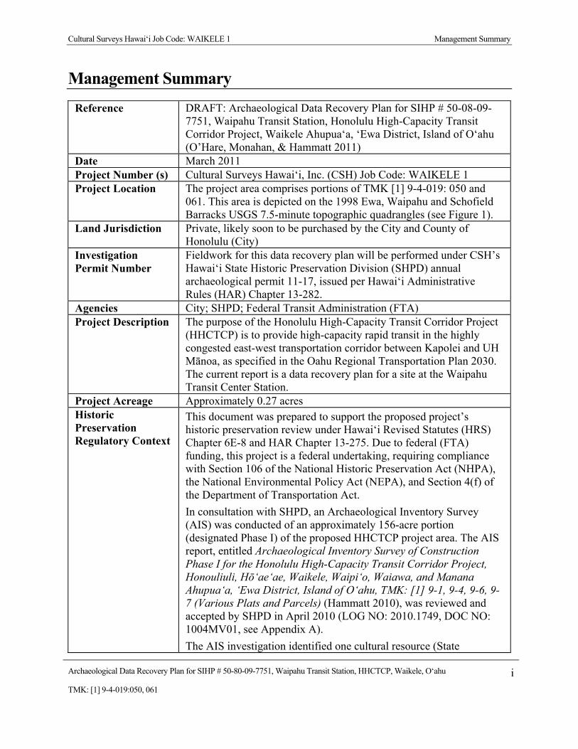
Management Summary
Reference DRAFT: Archaeological Data Recovery Plan for SIHP # 50-08-09-7751, Waipahu Transit Station, Honolulu High-Capacity Transit Corridor Project, Waikele Ahupua‘a, ‘Ewa District, Island of O‘ahu (O’Hare, Monahan, & Hammatt 2011)
Date March 2011 Project Number (s) Cultural Surveys Hawai‘i, Inc. (CSH) Job Code: WAIKELE 1 Project Location The project area comprises portions of TMK [1] 9-4-019: 050 and
061. This area is depicted on the 1998 Ewa, Waipahu and Schofield Barracks USGS 7.5-minute topographic quadrangles (see Figure 1).
Land Jurisdiction Private, likely soon to be purchased by the City and County of Honolulu (City)
Investigation Permit Number
Fieldwork for this data recovery plan will be performed under CSH’s Hawai‘i State Historic Preservation Division (SHPD) annual archaeological permit 11-17, issued per Hawai‘i Administrative Rules (HAR) Chapter 13-282.
Agencies City; SHPD; Federal Transit Administration (FTA) Project Description The purpose of the Honolulu High-Capacity Transit Corridor Project
(HHCTCP) is to provide high-capacity rapid transit in the highly congested east-west transportation corridor between Kapolei and UH Mānoa, as specified in the Oahu Regional Transportation Plan 2030. The current report is a data recovery plan for a site at the Waipahu Transit Center Station.
Project Acreage Approximately 0.27 acres Historic Preservation Regulatory Context
This document was prepared to support the proposed project’s historic preservation review under Hawai‘i Revised Statutes (HRS) Chapter 6E-8 and HAR Chapter 13-275. Due to federal (FTA) funding, this project is a federal undertaking, requiring compliance with Section 106 of the National Historic Preservation Act (NHPA), the National Environmental Policy Act (NEPA), and Section 4(f) of the Department of Transportation Act. In consultation with SHPD, an Archaeological Inventory Survey (AIS) was conducted of an approximately 156-acre portion (designated Phase I) of the proposed HHCTCP project area. The AIS report, entitled Archaeological Inventory Survey of Construction Phase I for the Honolulu High-Capacity Transit Corridor Project, Honouliuli, Hō‘ae‘ae, Waikele, Waipi‘o, Waiawa, and Manana Ahupua‘a, ‘Ewa District, Island of O‘ahu, TMK: [1] 9-1, 9-4, 9-6, 9-7 (Various Plats and Parcels) (Hammatt 2010), was reviewed and accepted by SHPD in April 2010 (LOG NO: 2010.1749, DOC NO: 1004MV01, see Appendix A). The AIS investigation identified one cultural resource (State
Cultural Surveys Hawai‘i Job Code: WAIKELE 1 Management Summary
Archaeological Data Recovery Plan for SIHP # 50-80-09-7751, Waipahu Transit Station, HHCTCP, Waikele, O‘ahu iiTMK: [1] 9-4-019:050, 061
Inventory of Historic Property [SIHP] # 50-80-09-7751) in the project area that may be affected by the proposed project. Under Hawaii State historic preservation review legislation, CSH’s project-specific effect recommendation was “effect, with proposed mitigation commitments.” Under federal historic preservation review legislation a project effect recommendation of “no adverse effect” was warranted, with the understanding that the proposed mitigation measures (described in this data recovery plan) are carried out to mitigate the undertaking’s potential effect to National register-eligible cultural resources. CSH has prepared this archaeological data recovery plan in consideration of the Secretary of the Interior’s Guidelines for Archeology and Historic Preservation, and in accordance with HAR 13-278 governing the preparation of data recovery programs. This plan was prepared in consideration of the project’s final January 2011 Programmatic Agreement Stipulation III.E.2. that describes data recovery programs.
Historic Property Addressed
This data recovery plan addresses SIHP # 50-80-09-7751, a subsurface cultural deposit (lo‘i sediments), evaluated as significant under Criterion D of the National and Hawai‘i Registers of Historic Places evaluation criteria. The subsurface agricultural deposit, interpreted as a traditional, pre-contact irrigated pondfield, was observed in the makai (southern) portion of the proposed Waipahu Transit Station immediately adjacent to, and south of, Farrington Highway. Based on the AIS investigation, the site, which is located beneath thick fill deposits, measures at least 65 ft by 25 ft, or approximately 0.04 acres. The lateral extent and boundaries of the site extend beyond the project area footprint and have not been established. The deposit consists of dark clay sediments containing charcoal flecks and abundant reddish-orange tubules and concretions typical of pondfield sediments in Hawai‘i. Radiocarbon dating suggests SIHP # 450-80-09-7751 may have formed as early as 1,000 years before present (details presented below).
Data Recovery Plan Summary
The research objectives for data recovery at SIHP # 50-80-09-7751 are: 1. To investigate the initial development of the irrigated taro fields
and their history of use; and 2. To research how buried pond sediments, or other low energy
alluvial sedimentary deposits within the project area, preserve an environmental record.
The data recovery study at SIHP # 50-80-09-7751 will consist of:

Cultural Surveys Hawai‘i Job Code: WAIKELE 1 Management Summary
Archaeological Data Recovery Plan for SIHP # 50-80-09-7751, Waipahu Transit Station, HHCTCP, Waikele, O‘ahu iiiTMK: [1] 9-4-019:050, 061
1. Backhoe testing of SIHP # 50-80-09-7751 and its vicinity to expose the deposit;
2. Subsurface collection of midden and cultural material from SIHP # 50-80-09-7751 bulk samples to obtain diagnostic items that may better define the age and specific function(s) of the site (presumed to include taro cultivation, but possibly including other cultivars);
3. Preparation of two columns of sediment samples and their submittal to an expert in palynomorph analysis; and
4. Radiocarbon dating of samples from the column samples and discrete charcoal sample (if available) to better define the age of the site.

Cultural Surveys Hawai‘i Job Code: WAIKELE 1
Archaeological Data Recovery Plan for SIHP # 50-80-09-7751, Waipahu Transit Station, HHCTCP, Waikele, O‘ahu ivTMK: [1] 9-4-019:050, 061
Table of Contents Management Summary ............................................................................................................ i
Section 1 Introduction ............................................................................................................. 1 1.1 Project Background ....................................................................................................................... 1 1.2 Historic Property Addressed .......................................................................................................... 1 1.3 Historic Preservation Regulatory Context ..................................................................................... 2 1.4 Scope of Work ............................................................................................................................... 6 1.5 Environmental Setting ................................................................................................................... 6
1.5.1 Natural Environment............................................................................................................... 6 1.5.2 Built Environment .................................................................................................................. 7
Section 2 Background Research ............................................................................................. 9 2.1 Wahi Pana (Place Names) of Waikele ........................................................................................... 9 2.2 Mo‘olelo (Stories) of Waikele ....................................................................................................... 9
2.2.1 Palila and Kamaika‘ahui, the Shark Man ............................................................................... 9 2.2.2 Waipahu Spring and the Tapa Board .................................................................................... 11
2.3 Historical Background ................................................................................................................. 11 2.3.1 Traditional Settlement and Agricultural Patterns ................................................................. 11 2.3.2 Mid-Nineteenth Century and the Māhele ............................................................................. 12 2.3.3 Mid-Nineteenth Century to the Present ................................................................................ 12
Section 3 Previous Archaeological Research ....................................................................... 18 3.1 Previous Archaeological Projects near the Data Recovery Study Area ....................................... 18
3.1.1 Hammatt and Chiogioji 2000 ................................................................................................ 18 3.1.2 Tulchin et al. 2009 ................................................................................................................ 18 3.1.3 Hammatt 2010 ...................................................................................................................... 20
3.2 Archaeological Inventory Survey Results -Waipahu Transit Station .......................................... 21 3.2.1 Pedestrian Survey ................................................................................................................. 21 3.2.2 GPR Survey .......................................................................................................................... 21 3.2.3 Archaeological Testing in the Mauka and Makai Portions of the Waipahu Transit Station . 21 3.2.4 Waipahu Transit Center Station Makai Trench 1 ................................................................. 23 3.2.5 State Inventory of Historic Properties (SIHP) # 50-08-09-7751 .......................................... 24 3.2.6 Results of Radiocarbon Analysis .......................................................................................... 27
Section 4 Archaeological Data Recovery Plan ..................................................................... 30 4.1 Research Objectives ..................................................................................................................... 30
4.1.1 Theoretical Orientation ......................................................................................................... 30 4.1.2 Research Objectives .............................................................................................................. 31 4.1.3 Data Requirements ................................................................................................................ 32
4.2 Trench Excavation ....................................................................................................................... 32 4.3 Sample Collection and Associated Laboratory Analysis ............................................................. 34
4.3.1 Bulk Screened Samples ........................................................................................................ 34 4.3.2 Column and Core Samples ................................................................................................... 35 4.3.3 Radiocarbon Dating .............................................................................................................. 36
4.4 Data Recovery Report Production ............................................................................................... 36 4.5 Disposition of Collections ........................................................................................................... 38

Cultural Surveys Hawai‘i Job Code: WAIKELE 1
Archaeological Data Recovery Plan for SIHP # 50-80-09-7751, Waipahu Transit Station, HHCTCP, Waikele, O‘ahu vTMK: [1] 9-4-019:050, 061
Section 5 References Cited .................................................................................................... 39
Appendix A SHPD Review Letter of the AIS ........................................................................ 1
Appendix B Land Commission Awards ................................................................................. 1
Cultural Surveys Hawai‘i Job Code: WAIKELE 1
Archaeological Data Recovery Plan for SIHP # 50-80-09-7751, Waipahu Transit Station, HHCTCP, Waikele, O‘ahu viTMK: [1] 9-4-019:050, 061
List of Figures Figure 1. 1998 U.S. Geological Survey 7.5 Minute map of O‘ahu, Ewa, Waipahu, and Schofield
Barracks Quadrangles, depicting the location of the HHCTCP Alignment, transit stations, park and ride facilities, and maintenance and storage facilities; the archaeological data recovery study area concerns the Waipahu Transit Center area ..........................................3
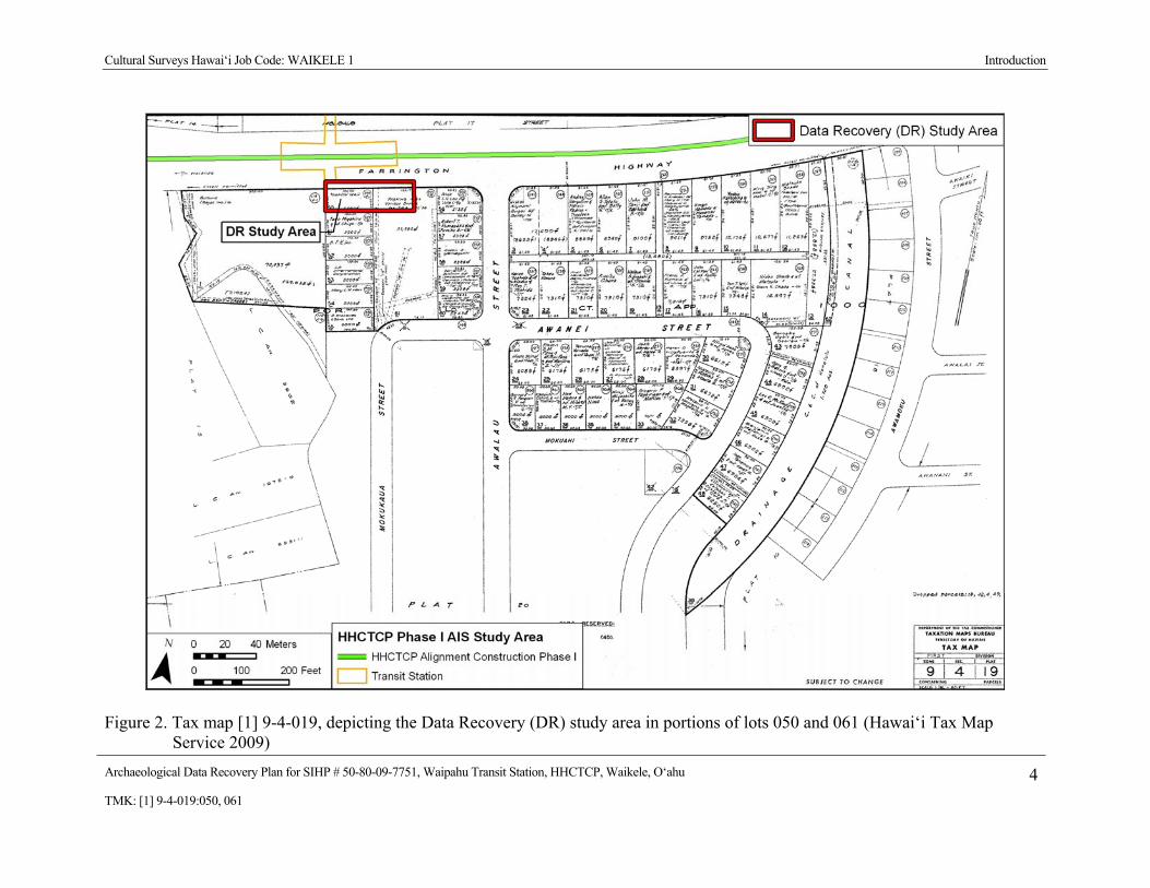
Figure 2. Tax map [1] 9-4-019, depicting the Data Recovery (DR) study area in portions of lots 050 and 061 (Hawai‘i Tax Map Service 2009) ....................................................................4
Figure 3. 2005 Aerial Photograph, depicting the proposed Waipahu Transit Center and the Data Recovery (DR) Study Area (U.S. Geological Survey Orthoimagery) .................................5
Figure 4. 2005 Aerial photograph (U.S. Geological Survey Orthoimagery) with soils depiction overlay (USDA 1972) ..........................................................................................................8
Figure 5. 1873 map of Pearl Harbor and Honouliuli (portion), by W. D. Alexander, showing the Data Recovery Study Area in a wetland adjacent to Waikele Stream (Alexander 1873, Registered Map No. 405, Hawai‘i Land Survey Division) ................................................10
Figure 6. 1899 map of Waikele (portion) by S. E. Bishop, depicting dense clusters of LCA claims adjacent to Waikele Stream; the Data Recovery Study Area is shown within the ‘ili of Onio (Registered Map No. 1498, Hawai‘i Land Survey Divisions) ........................13
Figure 7. 1927-1928 U.S. Geological Survey Map of O‘ahu (Waipahu Quadrangle), with the project area in relation to the urban center of Waipahu; the sugar mill of the Oahu Sugar Company is the large building in the center of town .........................................................16
Figure 8. 1978 Aerial photograph, showing the development of commercial centers and residential subdivisions near the Data Recovery Study Area (U.S. Geological Survey Orthophoto) ........................................................................................................................17
Figure 9. Previous Archaeological Studies near the Data Recovery Study Area (base map: 1998 U.S. Geological Survey map of O‘ahu, Ewa, Waipahu, and Schofield Barracks Quadrangles) ......................................................................................................................19
Figure 10. Waipahu Transit Center Archaeological Inventory Survey Subsurface Testing Locations; the current Data Recovery Study Area encompasses the Makai Testing Area (CSH overlay on 2005 U.S. Geological Survey Aerial photograph) .................................22
Figure 11. Profile of Waipahu Transit Center Station Makai Trench 1 .........................................23 Figure 12. Close up photograph of a sediment sample from SIHP # 50-80-09-7751 (black and
white scale in 1 cm units)...................................................................................................25 Figure 13. Close up photograph of iron oxyhydroxide root tubules (right) and precipitate
concretions (left) collected from sediment samples of SIHP # 50-80-09-7751 .................25 Figure 14. Land Court Application Map 1000 showing LCAs and ‘auwai in the vicinity of SIHP
#50-80-09-7751..................................................................................................................28 Figure 15. Proposed Location of Data Recovery (DR) Test Trench 1 and 2 (each 10 meters long
in Data Recovery Study Area (base map: Google Earth 2005) .........................................33

Cultural Surveys Hawai‘i Job Code: WAIKELE 1
Archaeological Data Recovery Plan for SIHP # 50-80-09-7751, Waipahu Transit Station, HHCTCP, Waikele, O‘ahu viiTMK: [1] 9-4-019:050, 061
List of Tables Table 1. Waipahu Transit Center Station – Makai Trench 1 Stratigraphy ....................................23 Table 2. SIHP # 50-08-09-7751 Site Description ..........................................................................24 Table 3. Results of Radiocarbon Analysis .....................................................................................29
Cultural Surveys Hawai‘i Job Code: WAIKELE 1 Introduction
Archaeological Data Recovery Plan for SIHP # 50-80-09-7751, Waipahu Transit Station, HHCTCP, Waikele, O‘ahu 1TMK: [1] 9-4-019:050, 061
Section 1 Introduction
1.1 Project Background At the request of Parsons Brinkerhoff (PB) Cultural Surveys Hawai‘i, Inc. (CSH) prepared
this archaeological data recovery plan for the City and County of Honolulu (City) and the Federal Transit Administration (FTA). The plan addresses mitigation efforts for State Inventory of Historic Places (SIHP) # 50-08-09-7751, previously recorded at the proposed Waipahu Transit Station, Construction Phase I Honolulu High-Capacity Transit Corridor Project (HHCTCP), Waikele Ahupua‘a, ‘Ewa District, Island of O‘ahu, TMK: [1] 9-4-019:050, 061. The entire proposed HHCTCP extends approximately 23 miles from Kapolei in the west to the University of Hawai‘i at Mānoa and Waikīkī in the east. The Phase I Construction project area extends through the ‘Ewa District, from Honouliuli Ahupua‘a to Manana Ahupua‘a. The area of the proposed Waipahu Transit Station is shown on a 1998 USGS 7.5-minute topographic map Ewa, Waipahu and Schofield Barracks quadrangles (Figure 1), a Hawai‘i State Tax Map (Figure 2), and a 2005 U.S. Geological Survey aerial photograph (Figure 3).
The HHCTCP will provide high-capacity rapid transit in the highly congested east-west transportation corridor between Kapolei and the University of Hawai‘i at Mānoa via a fixed guideway rail transit system. In addition to the guideway, the project will require construction of transit stations and support facilities, including a vehicle maintenance and storage facility and park-and-ride lots. Project construction will also require relocation of existing utility lines within the project corridor that conflict with the proposed project design. Minimally, land-disturbing activities would include grading of facility locations and excavations for guideway column foundations, subsurface utility relocation and installation, and facility construction.
1.2 Historic Property Addressed This data recovery plan addresses SIHP # 50-80-09-7751, a subsurface cultural deposit (lo‘i
sediments), evaluated as significant under Criterion D of the National and Hawai‘i Registers of Historic Places evaluation criteria.
The subsurface agricultural deposit, interpreted as a traditional, pre-contact irrigated pondfield, was observed in the makai (southern) portion of the proposed Waipahu Transit Station immediately adjacent to, and south of, Farrington Highway. Based on the AIS investigation, the site, which is located beneath thick fill deposits, measures at least 65 ft by 25 ft, or approximately 0.04 acres. The lateral extent and boundaries of the site extend beyond the project area footprint and have not been established.
The deposit consists of dark clay sediments containing charcoal flecks and abundant reddish-orange tubules and concretions typical of pondfield sediments in Hawai‘i. Radiocarbon dating suggests SIHP # 450-80-09-7751 formed approximately 1,000 years before present (details presented below).
Cultural Surveys Hawai‘i Job Code: WAIKELE 1 Introduction
Archaeological Data Recovery Plan for SIHP # 50-80-09-7751, Waipahu Transit Station, HHCTCP, Waikele, O‘ahu 2TMK: [1] 9-4-019:050, 061
1.3 Historic Preservation Regulatory Context This document was prepared to support the proposed project’s historic preservation review
under Hawai‘i Revised Statutes (HRS) Chapter 6E-8 and HAR Chapter 13-275. Due to federal (FTA) funding, this project is a federal undertaking, requiring compliance with Section 106 of the National Historic Preservation Act (NHPA), the National Environmental Policy Act (NEPA), and Section 4(f) of the Department of Transportation Act.
In consultation with SHPD, an Archaeological Inventory Survey (AIS) was conducted of an approximately 156-acre portion (designated Phase I) of the proposed HHCTCP project area. The AIS report, entitled Archaeological Inventory Survey of Construction Phase I for the Honolulu High-Capacity Transit Corridor Project, Honouliuli, Hō‘ae‘ae, Waikele, Waipi‘o, Waiawa, and Manana Ahupua‘a, ‘Ewa District, Island of O‘ahu, TMK: [1] 9-1, 9-4, 9-6, 9-7 (Various Plats and Parcels) (Hammatt 2010), was reviewed and accepted by SHPD in April 2010 (LOG NO: 2010.1749, DOC NO: 1004MV01, see Appendix A).
The AIS investigation identified one cultural resource (State Inventory of Historic Property [SIHP] # 50-80-09-7751) in the project area that may be affected by the proposed project. Under Hawaii State historic preservation review legislation, CSH’s project-specific effect recommendation was “effect, with proposed mitigation commitments.” Under federal historic preservation review legislation a project effect recommendation of “no adverse effect” was warranted, with the understanding that the proposed mitigation measures (described in this data recovery plan) are carried out to mitigate the undertaking’s potential effect to National register-eligible cultural resources.
CSH has prepared this archaeological data recovery plan in consideration of the Secretary of the Interior’s Guidelines for Archeology and Historic Preservation, and in accordance with Hawaii Administrative Rules (HAR) Chapter 13-278 governing the preparation of data recovery programs. This plan was prepared in consideration of the project’s final January 2011 Programmatic Agreement Stipulation III.E.2 that describes data recovery programs.
Fieldwork for this plan will be performed under CSH’s Hawai‘i State Historic Preservation Division (SHPD) annual archaeological permit 11-17, issued per Hawai‘i Administrative Rules (HAR) Chapter 13-282.

Cultural Surveys Hawai‘i Job Code: WAIKELE 1 Introduction
Archaeological Data Recovery Plan for SIHP # 50-80-09-7751, Waipahu Transit Station, HHCTCP, Waikele, O‘ahu 3TMK: [1] 9-4-019:050, 061
Figure 1. 1998 U.S. Geological Survey 7.5 Minute map of O‘ahu, Ewa, Waipahu, and Schofield Barracks Quadrangles, depicting the location of the HHCTCP Alignment, transit stations, park and ride facilities, and maintenance and storage facilities; the archaeological data recovery study area concerns the Waipahu Transit Center area
Cultural Surveys Hawai‘i Job Code: WAIKELE 1 Introduction
Archaeological Data Recovery Plan for SIHP # 50-80-09-7751, Waipahu Transit Station, HHCTCP, Waikele, O‘ahu 4TMK: [1] 9-4-019:050, 061
Figure 2. Tax map [1] 9-4-019, depicting the Data Recovery (DR) study area in portions of lots 050 and 061 (Hawai‘i Tax Map Service 2009)

Cultural Surveys Hawai‘i Job Code: WAIKELE 1 Introduction
Archaeological Data Recovery Plan for SIHP # 50-80-09-7751, Waipahu Transit Station, HHCTCP, Waikele, O‘ahu 5TMK: [1] 9-4-019:050, 061
Figure 3. 2005 Aerial Photograph, depicting the proposed Waipahu Transit Center and the Data Recovery (DR) Study Area (U.S. Geological Survey Orthoimagery)

Cultural Surveys Hawai‘i Job Code: WAIKELE 1 Introduction
Archaeological Data Recovery Plan for SIHP # 50-80-09-7751, Waipahu Transit Station, HHCTCP, Waikele, O‘ahu 6TMK: [1] 9-4-019:050, 061
1.4 Scope of Work This plan details the proposed data recovery of SIHP # 50-80-09-7751, subsurface
agricultural deposit.
Specific research goals and the appropriate types of data, as well as the appropriate methods for collecting these data, are outlined in the following requirements taken directly from HAR Chapter 13-278-4, the Hawaii State rules governing archaeological data recovery plans:
1. Identification of historic properties to be studied;
2. Identification of research objectives to be addressed;
3. Identification of data needed to address research objectives
4. Identification of field methods to be used to acquire and analyze the data;
5. Identification of necessary laboratory work;
6. Identification of procedures for the disposition of collections upon the conclusion of the data recovery action;
7. If burials are to be disinterred, a written data recovery plan is not required for inadvertent discoveries. For burials the procedures of section HAR Chapter 6E-43, and Hawai‘i Revised Statute (HRS) Chapter 13-300 shall be followed; [Note: no previously identified burials will be involved in this data recovery program and it is unlikely that inadvertent burial discoveries will be made during the fieldwork associated with this data recovery program.]
1.5 Environmental Setting
1.5.1 Natural Environment The Construction Phase I area is between 0.4 and 1.2 miles inland of the West and Middle
Lochs of Pearl Harbor. Terrain is fairly level with elevations between 20 and 40 feet above sea level, rising to 100 to 200 feet above sea level toward the eastern end. The sub-area receives an average of 24 to 31 inches of annual rainfall (Giambelluca et al. 1986).
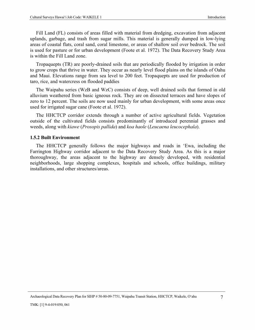
According to USDA soil survey data (Foote et al. 1972), sediments near the alternate wastewater facilities and tunnels, shown on are Fill Land (FL), TR (Tropaquepts), and soils of the Waipahu Series (WzB and WzC) (Figure 4).
Cultural Surveys Hawai‘i Job Code: WAIKELE 1 Introduction
Archaeological Data Recovery Plan for SIHP # 50-80-09-7751, Waipahu Transit Station, HHCTCP, Waikele, O‘ahu 7TMK: [1] 9-4-019:050, 061
Fill Land (FL) consists of areas filled with material from dredging, excavation from adjacent uplands, garbage, and trash from sugar mills. This material is generally dumped in low-lying areas of coastal flats, coral sand, coral limestone, or areas of shallow soil over bedrock. The soil is used for pasture or for urban development (Foote et al. 1972). The Data Recovery Study Area is within the Fill Land zone.
Tropaquepts (TR) are poorly-drained soils that are periodically flooded by irrigation in order to grow crops that thrive in water. They occur as nearly level flood plains on the islands of Oahu and Maui. Elevations range from sea level to 200 feet. Tropaquepts are used for production of taro, rice, and watercress on flooded paddies
The Waipahu series (WzB and WzC) consists of deep, well drained soils that formed in old alluvium weathered from basic igneous rock. They are on dissected terraces and have slopes of zero to 12 percent. The soils are now used mainly for urban development, with some areas once used for irrigated sugar cane (Foote et al. 1972).
The HHCTCP corridor extends through a number of active agricultural fields. Vegetation outside of the cultivated fields consists predominantly of introduced perennial grasses and weeds, along with kiawe (Prosopis pallida) and koa haole (Leucaena leucocephala).
1.5.2 Built Environment The HHCTCP generally follows the major highways and roads in ‘Ewa, including the
Farrington Highway corridor adjacent to the Data Recovery Study Area. As this is a major thoroughway, the areas adjacent to the highway are densely developed, with residential neighborhoods, large shopping complexes, hospitals and schools, office buildings, military installations, and other structures/areas.

Cultural Surveys Hawai‘i Job Code: WAIKELE 1 Introduction
Archaeological Data Recovery Plan for SIHP # 50-80-09-7751, Waipahu Transit Station, HHCTCP, Waikele, O‘ahu 8TMK: [1] 9-4-019:050, 061
Figure 4. 2005 Aerial photograph (U.S. Geological Survey Orthoimagery) with soils depiction overlay (USDA 1972)

Cultural Surveys Hawai‘i Job Code: WAIKELE 1 Background Research
Archaeological Data Recovery Plan for SIHP # 50-80-09-7751, Waipahu Transit Station, HHCTCP, Waikele, O‘ahu 9TMK: [1] 9-4-019:050, 061
Section 2 Background Research
2.1 Wahi Pana (Place Names) of Waikele Place names or wahi pana (“legendary place,” Pukui and Elbert 1986: 376) are an integral
part of Hawaiian culture. “In Hawaiian culture, if a particular spot is given a name, it is because an event occurred there which has meaning for the people of that time (McGuire 2000:23).”
Waikele extends from the north and eastern shore of the West Loch of Pearl Harbor on the makai (seaward) side to a boundary point between the District of Wahiawā and the ahupua‘a (land division) of Waipi‘o on the mauka (inland) side. It is at this boundary point that Sterling and Summers (1978:137), belive was the former location of a famous pōhaku called O‘ahunui, a stone shaped like the island of O‘ahu. Waikele is watered by Waikele Stream; the ridge on the east side of the stream marks the boundary with Waipi‘o. In upper Waikele, the stream is fed by two tributary streams, from the west Wai‘eli (possibly “dug water”) and from the east Waikakalaua (“water [rough] in rain”). Waikele means “muddy water,” probably a reference to this long stream. There were other names for the lower part of the stream, shown as Kapakahi (“crooked”) Stream on some maps, and referred to as Poniohua (possibly, “anointed on the night of Hua; Thrum 1922:667) Stream in some legends (Mauricio 1997:9). Surrounding the mouth of the stream was a large marsh, or wetland, as shown on an 1873 map of Pearl Harbor (Figure 5). The marsh was used for the irrigated cultivation of taro in pre-contact and early post-contact periods and later used for rice fields.
The most famous location in Waikele is Waipahu Spring (“bursting water”); the waters of this spring were used to irrigate many of the ancient taro patches on the Waikele flood plain and later the rice and sugar cane crops. As a town and sugar mill expanded around it, the entire makai area of Hō‘ae‘ae and Waikele became known as Waipahu, and the older names were no longer used.
Above the spring was a rock face called Pōhaku-pili (clinging stone), which was said to have been placed there by the Hawaiian pig-god, Kamapua‘a (Mauricio 1997:7). There were four heiau (ceremonial structure) in Waikele, two in the lowland area, just north of the present H-1 highway, and two in the uplands, near the head of Kīpapa Gulch. The two lower heiau, Mokoula and Hapupu, had been completely destroyed by or in the early twentieth century, but McAllister (1933:106-107) found (or was told of) remnants of the two upper heiau, Moaula, and the Heiau of ‘Umi, during his survey of prominent O‘ahu archaeological sites in the early 1930s.
2.2 Mo‘olelo (Stories) of Waikele
2.2.1 Palila and Kamaika‘ahui, the Shark Man In the legend of the hero Palila, the famous warrior had a supernatural war club. He could
throw the club a long distance, hang on to the end of it, and fly along the club’s path. Using this power, he touched down in several places in Honouliuli, Waipi‘o, and Waikele (Fornander 1919, Story of Palila, Vol. V, Part II:372-374). Kamaika‘ahui was a man who could take the form of a shark. In his human form, he had the mouth and teeth of a shark on his back. Whenever he got

Cultural Surveys Hawai‘i Job Code: WAIKELE 1 Background Research
Archaeological Data Recovery Plan for SIHP # 50-80-09-7751, Waipahu Transit Station, HHCTCP, Waikele, O‘ahu 10TMK: [1] 9-4-019:050, 061
Figure 5. 1873 map of Pearl Harbor and Honouliuli (portion), by W. D. Alexander, showing the Data Recovery Study Area in a wetland adjacent to Waikele Stream (Alexander 1873, Registered Map No. 405, Hawai‘i Land Survey Division)
Cultural Surveys Hawai‘i Job Code: WAIKELE 1 Background Research
Archaeological Data Recovery Plan for SIHP # 50-80-09-7751, Waipahu Transit Station, HHCTCP, Waikele, O‘ahu 11TMK: [1] 9-4-019:050, 061
the chance at his home in Hāna, Maui or his home in Waikele, O‘ahu, he would secretly change into his shark form, kill, and eat unsuspecting swimmers.
Ahapau, the king of O‘ahu, had promised to make king anyone who could drive Kamaika‘ahui away from O‘ahu. When Palila got to Waikele, he found Kamaika‘ahui. At one look of Palila’s war club, the shark-man ran away and tried to jump into the sea. But every time he tried to escape, Palila threw his war club, again and again, until finally he killed Kamaika‘ahui (Fornander 1918, Story of Palila, Vol. V: Part I:142-143).
2.2.2 Waipahu Spring and the Tapa Board The most famous wahi pana (“legendary place) in Waikele was the Waipahu Spring, which
was used as a bathing spot for the shark goddess of Pearl Harbor, Ka‘ahupahau (Sterling and Summers 1978:25). The spring was also known for a mo‘olelo concerning a tapa board. Tapa was placed on a wooden board (also called an anvil), and beaten by women with tapa sticks to often and smooth out the fibers. This pounding made a resonant sound, and women could often identify the owner of the board by the sound that was made. One day a woman in Kahuku on O‘ahu took her favorite tapa board to a pool to clean it and left it at the side of the pool. The next day the board was missing. The woman first searched the windward districts of the island, but never heard the distinctive ringing sound of her own favorite board. After several months without finding her board, she traveled to the leeward side of O‘ahu.
She went from Kahuku on the Koolau side to Kaneohe where she spent the night. There was no sign of the anvil in Koolau, because the sign she sought was the sound it made. . . . She went on and spent the night at Wailupe but did not find hers. She heard other anvils but they were not hers. The night turned into day and she went on to Kapalama where she slept but did not hear what she sought till she came to Waipahu. (Ka Loea Kalaiaina, June 10, 1899; English translation in Sterling and Summers 1978:25)
At Waipahu Spring in the ‘Ewa District, she finally heard the sound of her own board. She followed the sound to the uplands of Waikele and found a woman beating tapa on her board. The woman claimed that she had found the board one day floating on the water at a spring near her house. This legend illustrates the belief by the ancient Hawaiians that there were underground streams and passages that led from one side of the island to the other. In one version of this story, the people of ‘Ewa followed the woman back to Kahuku so that she could prove that the board was the same one she had lost. They wrapped a bundle of ti leaves and cast them into the pool near the house of the Kahuku woman. Then returning to ‘Ewa, they saw the same bundle of ti leaves a few days later in Waipahu at the spring. Because of this, the Waipahu spring was called Ka-puka-na-wai-o-Kahuku, which means “Outlet of water from Kahuku” (Sterling and Summer 1978:26).
2.3 Historical Background
2.3.1 Traditional Settlement and Agricultural Patterns Various Hawaiian legends and early historical accounts indicate that ‘Ewa was once widely
inhabited by pre-Contact populations, including the Hawaiian ali‘i (chiefly class). This would be
Cultural Surveys Hawai‘i Job Code: WAIKELE 1 Background Research
Archaeological Data Recovery Plan for SIHP # 50-80-09-7751, Waipahu Transit Station, HHCTCP, Waikele, O‘ahu 12TMK: [1] 9-4-019:050, 061
attributable for the most part to the plentiful marine and estuarine resources available at the coast, along which several sites interpreted as permanent habitations and fishing shrines have been located. Other attractive subsistence-related features of the district include irrigated lowlands suitable for wetland taro cultivation, as well as the lower forest area of the mountain slopes for the procurement of forest resources.
The lochs of Pearl Harbor were ideal for the construction of fishponds and fish traps. Forest resources along the slopes of the Wai‘anae Range probably acted as a viable subsistence alternative during times of famine and/or low rainfall (Handy 1940:211; Handy and Handy 1972:469-470). The upper valley slopes may have also been a resource for sporadic quarrying of basalt used in the manufacturing of stone tools.
2.3.2 Mid-Nineteenth Century and the Māhele In 1845, the Board of Commissioners to Quiet Land Titles, also called the Land Commission,
was established “for the investigation and final ascertainment or rejection of all claims of private individuals, whether natives or foreigners, to any landed property” (Chinen 1958:8). This led to the Māhele, the division of lands between the king of Hawai‘i, the ali‘i (chiefs), and the common people, which introduced the concept of private property into the Hawaiian society.
In the Māhele, the ahupua‘a of Waikele was awarded to the ali‘i Nahuina; he returned it to the government as a commutation fee to pay for the lands he kept for himself. Much of the most productive agricultural lands were awarded to several ali‘i (chiefly class) as ‘ili (land division) awards, such as the 199-acre award of the ‘ili of Auiole to Nāmāhana and Maawe, the 252-acre award for the ‘ili of Koalipea to Nāmakehā, and the 2829-acre award of Pouhala ‘Ili to Lūlūhiwalani. In all, 119 Land Commission Award (LCA) claims were made for the ahupua‘a, and 73 of these were awarded (Waihona ‘Aina 2010).
The proposed Waipahu Transit Station and the Data Recovery Study area are in a former wetland on both sides of Waikele Stream. This land was used for taro cultivation and was awarded as a dense cluster of Land Commission Awards, as shown on an 1899 map of Waikele (Figure 6). Two LCA lots overlap the proposed Waipahu Transit Station, LCA 1712 C, ‘Āpana (lot) 2, in the ‘ili (small land division) of Onio; and, LCA 7260, ‘Āpana :2, in the ‘ili of Kaeleku. The majority of the Data Recovery Study Area is within former government land that was sold as part of a Land Patent Grant to William Jones, but the northeast corner falls within the boundary of LCA1712-C. Information in the award records indicates that the makai region contained agricultural land used most often for growing taro, pasturelands, abundant loko (fish ponds), sand dunes, ‘auwai (ditches), and muliwai (estuary or river mouth). LCA 1712-C consisted of one houselot near the coast, and four lo’i (irrigated or ponded agricultural plots, usually used to grow taro).
2.3.3 Mid-Nineteenth Century to the Present The following sections contain a summary of historic background from the CSH
Archaeological Inventory Survey report (Hammatt 2010), with a focus on the post-contact history of Waikele.

Cultural Surveys Hawai‘i Job Code: WAIKELE 1 Background Research
Archaeological Data Recovery Plan for SIHP # 50-80-09-7751, Waipahu Transit Station, HHCTCP, Waikele, O‘ahu 13TMK: [1] 9-4-019:050, 061
Figure 6. 1899 map of Waikele (portion) by S. E. Bishop, depicting dense clusters of LCA claims adjacent to Waikele Stream; the Data Recovery Study Area is shown within the ‘ili of Onio (Registered Map No. 1498, Hawai‘i Land Survey Divisions)
Cultural Surveys Hawai‘i Job Code: WAIKELE 1 Background Research
Archaeological Data Recovery Plan for SIHP # 50-80-09-7751, Waipahu Transit Station, HHCTCP, Waikele, O‘ahu 14TMK: [1] 9-4-019:050, 061
2.3.3.1 Ranching
Subsequent to western contact in the area, the landscape of the ‘Ewa plain was adversely affected by the removal of the sandalwood forest, and the introduction of domesticated animals and new vegetation species. Domesticated animals, including goats, sheep and cattle, were brought to the Hawaiian Islands by Vancouver in the early 1790s, and allowed to graze freely about the land for some time after. L.A. Henke reports the existence of a longhorn cattle ranch in Wai‘anae on O‘ahu by at least 1840 (Frierson 1972:10). John Meek, an early resident of ‘Ewa, leased portions of Waikele for his large Lihue Ranch as early as 1856 (Taylor 1922:221). Exotic vegetation species were introduced into ‘Ewa as early as 1790. These typically included vegetation best suited to a terrain disturbed by the logging of sandalwood forest and eroded by animal grazing. Within the current study area, the majority of the (non-cultivated) vegetation is comprised of introduced species, mainly grasses.
2.3.3.2 Rice Cultivation
As the sugar industry throughout the Hawaiian kingdom expanded in the second half of the 19th century, the need for increased numbers of field laborers prompted passage of contract labor laws. In 1852 the first Chinese contract laborers arrived in the islands. As was happening in other locales, in the 1880s, groups of Chinese began leasing and buying — from the Hawaiians of ‘Ewa former taro lands for conversion to rice farming. The taro lands’ availability throughout the islands in the late 1800s reflected the declining demand for taro as the native Hawaiian population diminished. By the early decades of the 20th century rice farming in the Hawaiian Islands was in decline, beset by crop diseases and cheaper prices for mainland-grown rice. Commercial agriculture in ‘Ewa became dominated by sugar with the development of the three sugar companies of ‘Ewa (Nedbalek 1984:13).
2.3.3.3 Pineapple Cultivation
In the early decades of the twentieth century, lands in the mauka portion of the central and eastern sections of ‘Ewa were being acquired for pineapple cultivation. James Dole founded the Hawaiian Pineapple Company in 1901 (Bruggencate 2004:27). The previous year, Dole had purchased 61 acres of land in Wahiawa for growing pineapple. A cannery was constructed by the Pearl City Fruit Company in Waiawa and later became part of the Hawaiian Pineapple Company operations after the Pearl City Fruit Company went bankrupt. The cannery was in operation from 1905 to 1935 (Bruggencate 2004:34).
2.3.3.4 Oahu Railway and Land Company (OR&L) and the Oahu Sugar Co.
In 1886, James Campbell and B. F. Dillingham put together the “Great Land Colonization Scheme,” which was an attempt to sell Honouliuli land to homesteaders (Thrum 1887:74). This homestead idea failed; two factors for the failure were the lack of water and the other was the distance from ‘Ewa to Honolulu. The water problem was solved by the drilling of artesian wells, and Dillingham decided that the area could be used instead for large-scale cultivation of sugar (Pagliaro 1987:4). The transportation problem was to be solved by the construction of a railroad, which B. Franklin Dillingham soon began to finance under the company name of the Oahu
Cultural Surveys Hawai‘i Job Code: WAIKELE 1 Background Research
Archaeological Data Recovery Plan for SIHP # 50-80-09-7751, Waipahu Transit Station, HHCTCP, Waikele, O‘ahu 15TMK: [1] 9-4-019:050, 061
Railway and Land Company (OR&L). This railroad line eventually ran across the center of the ‘Ewa Plain at the lower boundary of the sugar fields throughout ‘Ewa.
In 1897, B. F. Dillingham established the Oahu Sugar Company (OSCo) on 12,000 acres leased from the estates of John Papa ‘Ī‘ī, Bishop, and Robinson. The Oahu Sugar Co. had over 900 field workers, composed of 44 Hawaiians, 473 Japanese, 399 Chinese, and 57 Portuguese. The first sugar crop was harvested in 1899, ushering in the sugar plantation era in Waipahu (Ohira 1997). The sugar mill was built in Waikele Ahupua‘a in the town of Wahiawa, which became the urban center of the area. , as shown on a 1927-1928 map of O‘ahu (Figure 7).
2.3.3.5 The Military and Urban Development of Waikele
The reciprocity treaty between the United States and Hawai‘i was concluded in 1876 with the provision that Hawai‘i would not “lease or relinquish sovereignty to another country or any harbor, etc.” In 1887, the treaty was renewed and amended and allowed the United States the “exclusive right to enter the harbor of Pearl River, in the Island of Oahu, at to establish and to maintain there a coaling and repair station for the use of vessels of the United States” (Judd 1971:128). After annexation of the islands to the United States in 1899, development began in order to make a Pacific base that could be used as a staging area for the Spanish-American war (Coletta 1985:433). Early in the twentieth century, the U.S. Government began acquiring the coastal lands of ‘Ewa for the development of a naval base at Pearl Harbor. By the late 1950s, the military bases and housing areas began to shrink, and urban residential and commercial areas were developed over most of the coastal Waikele area, as shown on a 1978 aerial photograph (Figure 8).

Cultural Surveys Hawai‘i Job Code: WAIKELE 1 Background Research
Archaeological Data Recovery Plan for SIHP # 50-80-09-7751, Waipahu Transit Station, HHCTCP, Waikele, O‘ahu 16TMK: [1] 9-4-019:050, 061
Figure 7. 1927-1928 U.S. Geological Survey Map of O‘ahu (Waipahu Quadrangle), with the project area in relation to the urban center of Waipahu; the sugar mill of the Oahu Sugar Company is the large building in the center of town

Cultural Surveys Hawai‘i Job Code: WAIKELE 1 Background Research
Archaeological Data Recovery Plan for SIHP # 50-80-09-7751, Waipahu Transit Station, HHCTCP, Waikele, O‘ahu 17TMK: [1] 9-4-019:050, 061
Figure 8. 1978 Aerial photograph, showing the development of commercial centers and residential subdivisions near the Data Recovery Study Area (U.S. Geological Survey Orthophoto)

Cultural Surveys Hawai‘i Job Code: WAIKELE 1 Previous Archaeological Research
Archaeological Data Recovery Plan for SIHP # 50-80-09-7751, Waipahu Transit Station, HHCTCP, Waikele, O‘ahu 18TMK: [1] 9-4-019:050, 061
Section 3 Previous Archaeological Research
3.1 Previous Archaeological Projects near the Data Recovery Study Area
There have been a number of archaeological projects conducted along Farrington Highway and the coastal portions of ‘Ewa, as described in full in the HHCTCP Archaeological Inventory Survey Report (Hammatt 2010:96-105). Two previous archaeological projects (Hammatt and Chiogioji 2000; Tulchin et al. 2009) overlap or are adjacent to the proposed Waipahu Transit Station and the Data Recovery Study Area, as shown in Figure 9. In addition, archaeological survey and testing was conducted by CSH in the current Data Recovery Study Area during the Archaeological Inventory Survey for Construction Phase I of the HHCTCP project in 2009-2010 (Hammatt 2010).
3.1.1 Hammatt and Chiogioji 2000 In 2000, CSH prepared an archaeological assessment of an approximately 2,600-foot-long
portion of Farrington Highway for proposed improvements between Anini Place and Waipahu Depot Road in Waikele (Hammatt and Chiogioji 2000). Background research indicated that the study area ran along land that was, until the mid-19th century, lo‘i (irrigated agricultural plots). Many of the lo‘i were replaced by rice fields in the 20th century. During the 20th century, O‘ahu Sugar Company had been established and Waipahu Town developed around the sugar mill and plantation. OR&L tracks ran perpendicular across Hammatt and Chiogioji’s (2000) study area. Background research also indicated the study area includes historic buildings and constructions more than 50 years old. The historic features mentioned in the report include a railway overpass on the makai side of Farrington Highway with a drainage canal bridge constructed in the late 1930s (which had no markings or relation to the OR&L) and the St. Joseph Church and school, also on the makai side of Farrington Highway, built in 1940s. St. Joseph Church and school are in use today, are not currently listed on either the State or National Register of Historic Places, and do not appear to have been evaluated for State or National Register eligibility. Background research also indicated that no archaeological inventory surveys had been conducted within the current Farrington Highway sub-area or within the immediate vicinity. In addition, no surface archaeological resources were observed, indicating little likelihood of finding prehistoric surface or subsurface archaeological remains since all areas along the study area have been subjected to decades of urban development that would have removed any surface remnants related to traditional Hawaiian activities.
3.1.2 Tulchin et al. 2009
In 2009, CSH conducted an archaeological inventory story of a trunk sewer alignment for the proposed Koa Ridge Makai Development Project, which encompasses approximately 574 acres located between Kīpapa Gulch and the H-2 Freeway. A 100% pedestrian inspection of the entire project area was conducted and one historic property was identified. SIHP No. 50-80-09-6959 consists of an irrigation ditch and water control box located at the northern tip of the project area, approximately 6 m southwest of Kamehameha Highway, along the upslope edge of a road cut.

Cultural Surveys Hawai‘i Job Code: WAIKELE 1 Previous Archaeological Research
Archaeological Data Recovery Plan for SIHP # 50-80-09-7751, Waipahu Transit Station, HHCTCP, Waikele, O‘ahu 19TMK: [1] 9-4-019:050, 061
Figure 9. Previous Archaeological Studies near the Data Recovery Study Area (base map: 1998 U.S. Geological Survey map of O‘ahu, Ewa, Waipahu, and Schofield Barracks Quadrangles)
Cultural Surveys Hawai‘i Job Code: WAIKELE 1 Previous Archaeological Research
Archaeological Data Recovery Plan for SIHP # 50-80-09-7751, Waipahu Transit Station, HHCTCP, Waikele, O‘ahu 20TMK: [1] 9-4-019:050, 061
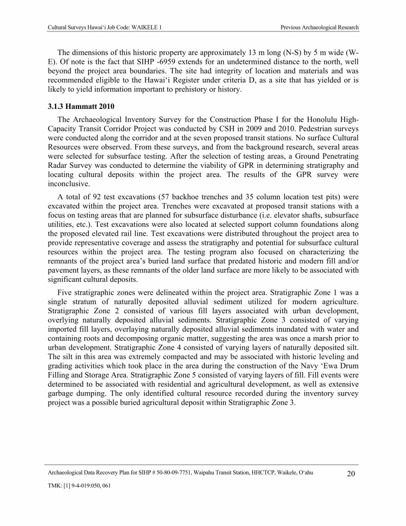
The dimensions of this historic property are approximately 13 m long (N-S) by 5 m wide (W-E). Of note is the fact that SIHP -6959 extends for an undetermined distance to the north, well beyond the project area boundaries. The site had integrity of location and materials and was recommended eligible to the Hawai‘i Register under criteria D, as a site that has yielded or is likely to yield information important to prehistory or history.
3.1.3 Hammatt 2010 The Archaeological Inventory Survey for the Construction Phase I for the Honolulu High-
Capacity Transit Corridor Project was conducted by CSH in 2009 and 2010. Pedestrian surveys were conducted along the corridor and at the seven proposed transit stations. No surface Cultural Resources were observed. From these surveys, and from the background research, several areas were selected for subsurface testing. After the selection of testing areas, a Ground Penetrating Radar Survey was conducted to determine the viability of GPR in determining stratigraphy and locating cultural deposits within the project area. The results of the GPR survey were inconclusive.
A total of 92 test excavations (57 backhoe trenches and 35 column location test pits) were excavated within the project area. Trenches were excavated at proposed transit stations with a focus on testing areas that are planned for subsurface disturbance (i.e. elevator shafts, subsurface utilities, etc.). Test excavations were also located at selected support column foundations along the proposed elevated rail line. Test excavations were distributed throughout the project area to provide representative coverage and assess the stratigraphy and potential for subsurface cultural resources within the project area. The testing program also focused on characterizing the remnants of the project area’s buried land surface that predated historic and modern fill and/or pavement layers, as these remnants of the older land surface are more likely to be associated with significant cultural deposits.
Five stratigraphic zones were delineated within the project area. Stratigraphic Zone 1 was a single stratum of naturally deposited alluvial sediment utilized for modern agriculture. Stratigraphic Zone 2 consisted of various fill layers associated with urban development, overlying naturally deposited alluvial sediments. Stratigraphic Zone 3 consisted of varying imported fill layers, overlaying naturally deposited alluvial sediments inundated with water and containing roots and decomposing organic matter, suggesting the area was once a marsh prior to urban development. Stratigraphic Zone 4 consisted of varying layers of naturally deposited silt. The silt in this area was extremely compacted and may be associated with historic leveling and grading activities which took place in the area during the construction of the Navy ‘Ewa Drum Filling and Storage Area. Stratigraphic Zone 5 consisted of varying layers of fill. Fill events were determined to be associated with residential and agricultural development, as well as extensive garbage dumping. The only identified cultural resource recorded during the inventory survey project was a possible buried agricultural deposit within Stratigraphic Zone 3.

Cultural Surveys Hawai‘i Job Code: WAIKELE 1 Previous Archaeological Research
Archaeological Data Recovery Plan for SIHP # 50-80-09-7751, Waipahu Transit Station, HHCTCP, Waikele, O‘ahu 21TMK: [1] 9-4-019:050, 061
3.2 Archaeological Inventory Survey Results -Waipahu Transit Station
3.2.1 Pedestrian Survey The site for the proposed Waipahu Transit Center Station is situated in a lot with a small
business located on the mauka/northern side of the road. The makai /south section of the station was formerly occupied by a used car lot. Urban development around the lot has generated significant land disturbance, which would have removed any surface cultural resources that may have been present. No surface cultural resources were observed within this portion of the project area.
3.2.2 GPR Survey Twelve test trenches were excavated at the Waipahu Transit Station. Prior to the excavation of
test excavations, the test areas were surveyed with ground penetrating radar (GPR). The GPR survey was conducted to determine the viability of GPR in determining stratigraphy and locating cultural deposits. Following the GPR survey, the test areas were excavated to compare the results of the GPR survey with the observed stratigraphy.
In general, the results of the GPR survey were inconclusive. The GPR was able to locate subsurface objects (a concrete utility jacket and buried asphalt fragments) in Waipahu Transit Center Station Mauka trenches 1 and 6, but was unable to identify subsurface utilities in the column tests. It is believed that the presence of thick wet clay deposits in this area was the primary factor to the inconsistent results of the GPR data. Clay soils (especially those that are inundated) are noted as being very conductive, resulting in radio wave attenuation at shallow depths causing limited depth “visibility” and inaccurate GPR data collection (Conyers 2004).
3.2.3 Archaeological Testing in the Mauka and Makai Portions of the Waipahu Transit Station Twelve test trenches were excavated near the Waipahu Transit Station, six in the mauka
(north) section and six in a makai (south) section (Figure 10). In general, the observed and documented stratigraphy consisted of varying imported fill layers overlying naturally deposited alluvial sediment inundated with water, suggesting the area was once a marsh prior to urban development. The fill layers appear to be associated with two distinct events: 1) mass grading and filling associated with land reclamation, and 2) asphalt parking lot construction. Of note was the presence of reddish orange mottling and charcoal flecking within the marsh sediments (Stratum II) observed at the makai (southern) portion of the proposed Waipahu Station. These inclusions are suggestive that agriculture, specifically taro cultivation, had occurred in this area prior to urban development. A review of LCA documentation for the area confirmed that lo‘i (wetland taro fields) were present in the area. Accordingly, the buried agricultural sediments were determined to be a cultural resource, and designated as State Inventory of Historic Properties (SIHP) # 50-80-09-7751.

Cultural Surveys Hawai‘i Job Code: WAIKELE 1 Previous Archaeological Research
Archaeological Data Recovery Plan for SIHP # 50-80-09-7751, Waipahu Transit Station, HHCTCP, Waikele, O‘ahu 22TMK: [1] 9-4-019:050, 061
Figure 10. Waipahu Transit Center Archaeological Inventory Survey Subsurface Testing Locations; the current Data Recovery Study Area encompasses the Makai Testing Area (CSH overlay on 2005 U.S. Geological Survey Aerial photograph)

Cultural Surveys Hawai‘i Job Code: WAIKELE 1 Previous Archaeological Research
Archaeological Data Recovery Plan for SIHP # 50-80-09-7751, Waipahu Transit Station, HHCTCP, Waikele, O‘ahu 23TMK: [1] 9-4-019:050, 061
3.2.4 Waipahu Transit Center Station Makai Trench 1 The stratigraphy for Makai Trench 1 in the Waipahu Transit Center Station is summarized in
Table 1 and shown on Figure 11.
Table 1. Waipahu Transit Center Station – Makai Trench 1 Stratigraphy
Stratum Depth (cmbs) Description Ia 0-10 Asphalt Ib 10-30 Crushed coral fill
Ic 30-100 Fill; 10 YR 3/4, dark yellowish brown; clay loam; moderate, medium, crumb structure; dry, hard consistency; plastic; weak cementation; abrupt boundary; smooth topography; terrestrial origin. Imported sediment associated with urban development of former wetland environment. Layer of basalt cobbles observed at the interface of underlying wetland sediments, indicative of land reclamation construction techniques.
II 100-200 10 YR 2/1, black; clay; moderate, medium; blocky structure; moist, firm consistency; very plastic; no cementation; terrestrial origin. Naturally deposited alluvial sediment inundated with water suggesting the area was once a marsh prior to urban development. Contains reddish orange mottling and charcoal flecking, which is indicative of wetland taro agriculture (see the SIHP # 50-80-09-7751 historic property description).
Figure 11. Profile of Waipahu Transit Center Station Makai Trench 1
Cultural Surveys Hawai‘i Job Code: WAIKELE 1 Previous Archaeological Research
Archaeological Data Recovery Plan for SIHP # 50-80-09-7751, Waipahu Transit Station, HHCTCP, Waikele, O‘ahu 24TMK: [1] 9-4-019:050, 061
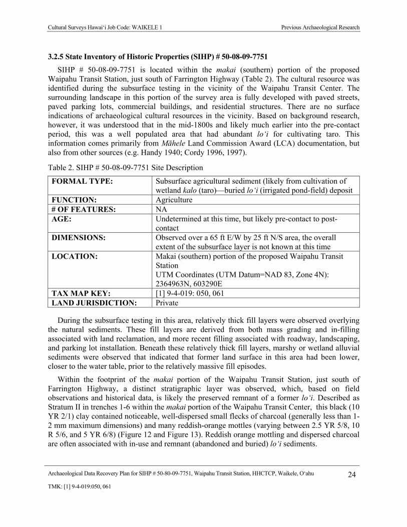
3.2.5 State Inventory of Historic Properties (SIHP) # 50-08-09-7751 SIHP # 50-08-09-7751 is located within the makai (southern) portion of the proposed
Waipahu Transit Station, just south of Farrington Highway (Table 2). The cultural resource was identified during the subsurface testing in the vicinity of the Waipahu Transit Center. The surrounding landscape in this portion of the survey area is fully developed with paved streets, paved parking lots, commercial buildings, and residential structures. There are no surface indications of archaeological cultural resources in the vicinity. Based on background research, however, it was understood that in the mid-1800s and likely much earlier into the pre-contact period, this was a well populated area that had abundant lo‘i for cultivating taro. This information comes primarily from Māhele Land Commission Award (LCA) documentation, but also from other sources (e.g. Handy 1940; Cordy 1996, 1997).
Table 2. SIHP # 50-08-09-7751 Site Description
FORMAL TYPE: Subsurface agricultural sediment (likely from cultivation of wetland kalo (taro)—buried lo‘i (irrigated pond-field) deposit
FUNCTION: Agriculture # OF FEATURES: NA AGE: Undetermined at this time, but likely pre-contact to post-
contact DIMENSIONS: Observed over a 65 ft E/W by 25 ft N/S area, the overall
extent of the subsurface layer is not known at this time LOCATION: Makai (southern) portion of the proposed Waipahu Transit
Station UTM Coordinates (UTM Datum=NAD 83, Zone 4N): 2364963N, 603290E
TAX MAP KEY: [1] 9-4-019: 050, 061 LAND JURISDICTION: Private
During the subsurface testing in this area, relatively thick fill layers were observed overlying the natural sediments. These fill layers are derived from both mass grading and in-filling associated with land reclamation, and more recent filling associated with roadway, landscaping, and parking lot installation. Beneath these relatively thick fill layers, marshy or wetland alluvial sediments were observed that indicated that former land surface in this area had been lower, closer to the water table, prior to the relatively massive fill episodes.
Within the footprint of the makai portion of the Waipahu Transit Station, just south of Farrington Highway, a distinct stratigraphic layer was observed, which, based on field observations and historical data, is likely the preserved remnant of a former lo‘i. Described as Stratum II in trenches 1-6 within the makai portion of the Waipahu Transit Center, this black (10 YR 2/1) clay contained noticeable, well-dispersed small flecks of charcoal (generally less than 1-2 mm maximum dimensions) and many reddish-orange mottles (varying between 2.5 YR 5/8, 10 R 5/6, and 5 YR 6/8) (Figure 12 and Figure 13). Reddish orange mottling and dispersed charcoal are often associated with in-use and remnant (abandoned and buried) lo‘i sediments.

Cultural Surveys Hawai‘i Job Code: WAIKELE 1 Previous Archaeological Research
Archaeological Data Recovery Plan for SIHP # 50-80-09-7751, Waipahu Transit Station, HHCTCP, Waikele, O‘ahu 25TMK: [1] 9-4-019:050, 061
Figure 12. Close up photograph of a sediment sample from SIHP # 50-80-09-7751 (black and white scale in 1 cm units)
Figure 13. Close up photograph of iron oxyhydroxide root tubules (right) and precipitate concretions (left) collected from sediment samples of SIHP # 50-80-09-7751

Cultural Surveys Hawai‘i Job Code: WAIKELE 1 Previous Archaeological Research
Archaeological Data Recovery Plan for SIHP # 50-80-09-7751, Waipahu Transit Station, HHCTCP, Waikele, O‘ahu 26TMK: [1] 9-4-019:050, 061
A. Rose Schilt made the following observations while working with buried and abandoned lo‘i sediments in Hanalei Valley, Kauai:
Previous archaeological projects in Mākaha Valley, O‘ahu, and Hālawa Valley, Molokai have documented the appearance of pondfield soils in which irrigated taro has been cultivated (Morgenstein and Burnett 1972; Riley 1975). These soils are characterized by hydrated iron-oxide (limonite) tubes which appear as prominent reddish mottles. These ferrogenous tubes are known to develop around the roots of taro plants, although the mechanism of concentration is not well understood . . . These tubes or mottles were quite prominent in the soil core we took in a recently cultivated lo‘i in Hanalei Valley. (Schilt 1980:29)
Regarding her extensive investigations of former lo‘i in Luluku, Kāneohe, O‘ahu, Jane Allen made the following observations:
In ponded soils, aeration along roots also oxidizes small areas in the subsoil, resulting in bright mottling within a dark, glayed soil matrix; precipitates of iron and manganese as limonite casts and manganese nodules, respectively, often occur . . . Charcoal in pondfields is typically churned and dispersed throughout the soil through subsequent cultivation and ponding activities. (Allen et al. 1987:36)
Morgenstein’s work with abandoned and buried lo‘i sediments in Kawainui Marsh, Kailua, O‘ahu documented abundant diffused charcoal particles and former root tubes stained red/orange with “ferruginous oxyhydroxides,” which were interpreted as directly related to the function of former pond fields (e.g. taro cultivation) (Morgenstein 1978:7-8). Based on Morgenstein’s (1978) sediment profiles, the iron oxyhydroxide root tubes he observed in Kawainui Marsh were quite pronounced and very “tube-like.” The stratum II observed at the makai portion of the Waipahu Transit Center (SIHP # 50-08-09-7751) clearly had diffuse charcoal particles and red-orange mottling, but the pronounced tube-like structures observed by Morgenstein (1978) where not visible during field observations.
It was only back in the laboratory, where sediment samples collected from SIHP # 50-08-09-7751 were wet screened through 1/16-inch mesh, that the pronounced reddish-orange tubules and precipitate concretions were observed. Five sediment samples from SIHP # 50-08-09-7751, each approximately three liters in volume, were wet screened. The reddish-orange concretions were observed in all samples; the root tubules were observed in three of the five samples. The observed tubules are generally between 1.0 and 1.5 cm long and between 2.0 and 5.0 mm in diameter.
During the documentation of the six trenches within the makai portion of the Waipahu Transit Center, no berms, channels, or other potential field components or infrastructure were observed. The boundaries of this subsurface deposit are currently unknown, as the testing for the current investigation was limited to the project’s footprint. It is clear that this agricultural deposit was subsequently buried by modern fill events that brought the land surface to its current elevation. During these fill events, the deposit may well have been disturbed and cut away to varying degrees.

Cultural Surveys Hawai‘i Job Code: WAIKELE 1 Previous Archaeological Research
Archaeological Data Recovery Plan for SIHP # 50-80-09-7751, Waipahu Transit Station, HHCTCP, Waikele, O‘ahu 27TMK: [1] 9-4-019:050, 061
Historic maps indicate numerous LCAs and ‘auwai (traditional irrigation ditches) in the vicinity of SIHP #50-08-09-7751 (Figure 14). Documentation from LCA 17120C and LCA 7260, both in the immediate vicinity of SIHP # 50-08-09-7751, indicate that wetland taro cultivation (lo‘i) was on-going in the area during the 1850s (see Appendix B for copies of this LCA testimony). The presence of ‘auwai and LCAs documenting wetland taro cultivation provide further evidence indicating that the clay deposit designated SIHP #50-08-09-7751, is likely a remnant of traditional Hawaiian agricultural activities.
Section 3.2.6, below, describes the results of radiocarbon dating at SIHP # 50-08-09-7751. These radiocarbon dating results are inconclusive because they are based on the analysis of bulk carbon from sediment samples as a whole rather than from charcoal from a discrete feature or specific event. These dating results indicate that the organic component of the sediments within SIHP #50-08-09-7751 was already formed approximately 1000 years ago. Additional dating is required to determine the actual time frame for agricultural use of the pondfield sediments for irrigated agriculture. Based on contextual information, the deposit’s agricultural use likely began during the pre-contact period and continued post-contact. Further investigation is required to substantiate this.
Admittedly, there is not a great deal of information available regarding SIHP # 50-08-09-7751, the remnant subsurface agricultural layer at the makai Waipahu Transit Center. Its boundaries are unknown and the radiocarbon dating results on sediment samples are problematic. Based on stratigraphic observations and historic data, however, there is little doubt that these deposits represent the buried remnants of former lo‘i. These deposits, on further investigation, can provide information on the age of the agricultural activity (best results are from radiocarbon dates from specific structural features, for example pond field berms). Information regarding periods of abandonment and reconstruction of the pond fields may be obtainable—allowing for chronological reconstructions of field use over time. Through palynological analysis, these deposits can also provide information on the surrounding environment (e.g., were the pollen in the surrounding watershed mostly indigenous species, Polynesian-introduced species, or Western-introduced species—and possibly how that pollen spectrum changed over time).
SIHP # 50-08-09-7751 has integrity of location and materials, but not integrity of design, setting, workmanship, feeling, or association. It was determined National and Hawaii Register eligible under significance criterion D, for the archaeological information that it contains.
3.2.6 Results of Radiocarbon Analysis
Sediment collected from SIHP #50-08-09-7751 was sent to Beta Analytic, Inc. for radiocarbon dating, utilizing the accelerator mass spectrometry (AMS) method, in order to better establish its period of use. Dating results are shown in Table 3 below. Two samples from SIHP # 50-08-09-7751 were submitted for radiocarbon dating analysis. Both samples consisted of organically enriched sediment that contained small (generally 1.0 mm or less in maximal dimensions) charcoal flecks. Charcoal extraction from these sediment samples did not yield sufficient total carbon for AMS analysis; accordingly, AMS analysis was done on the bulk carbon that was extracted from the sediment samples themselves.
The first sample (Beta-267036) yielded one possible date range, a calibrated 2-sigma (95% probability) date of AD 990-1170. The second sample (Beta-267037) yielded one possible date

Cultural Surveys Hawai‘i Job Code: WAIKELE 1 Previous Archaeological Research
Archaeological Data Recovery Plan for SIHP # 50-80-09-7751, Waipahu Transit Station, HHCTCP, Waikele, O‘ahu 28TMK: [1] 9-4-019:050, 061
Figure 14. Land Court Application Map 1000 showing LCAs and ‘auwai in the vicinity of SIHP #50-80-09-7751

Cultural Surveys Hawai‘i Job Code: WAIKELE 1 Previous Archaeological Research
Archaeological Data Recovery Plan for SIHP # 50-80-09-7751, Waipahu Transit Station, HHCTCP, Waikele, O‘ahu 29TMK: [1] 9-4-019:050, 061
range, a calibrated 2-sigma (95% probability) date range of AD 1010-1190. As stated above, however, these dates are potentially problematic because they date the accumulation of organic material in the sediment itself, which may or may not be related to the actual use of the sediment for agriculture. Further dating is required to more concretely determine the actual agricultural use of the pondfield sediments for irrigated agriculture.
Table 3. Results of Radiocarbon Analysis
Sample # Beta # Type Trench Stratum Depth (cmbs)
Weight (g)
Calibrated 2-Sigma Date Range
WAIPAHU KAI 01
267036 Organic Sediment
6 II 115-150 1000 AD 990-1170 (95%)
WAIPAHU KAI 02
267037 Organic Sediment
1 II 100-125 1000 AD 1010-1190 (95%)

Cultural Surveys Hawai‘i Job Code: WAIKELE 1 Archaeological Data Recovery Plan
Archaeological Data Recovery Plan for SIHP # 50-80-09-7751, Waipahu Transit Station, HHCTCP, Waikele, O‘ahu 30TMK: [1] 9-4-019:050, 061
Section 4 Archaeological Data Recovery Plan
4.1 Research Objectives
4.1.1 Theoretical Orientation Past Hawaiian archaeological research has been largely grounded in the “settlement-pattern
approach” (Kirch 1985:19) under which artifacts, deposits, and features are studied as components of an overall cultural landscape. Human interactions with their environment, and the resulting physical remnants, are viewed as components and/or adaptations that contribute to an ecological “system.” Although criticisms of this theoretical approach focus on its often synchronic view of the archeological record, a great deal of Hawaiian archaeology has been completed under this theoretical paradigm, with abundant results (Kirch 1985:19-20; Kirch 1999).
Over the last two decades, Pacific Archaeology has increasingly adopted a new theoretical orientation, based on interdisciplinary research focused on diachronic change of island ecosystems. Central to this research is the role of humans in changing island environments. This intermeshing of archaeology/anthropology and the natural sciences has been termed “historical ecology,” a term that has been defined by Carole Crumley (1994:6) as “the study of past ecosystems by charting the change in landscapes over time.” Historical ecology has also been defined as the “study of the complex, historical interactions between populations and the ecosystems they have inhabited” (Kirch 1997:2).
Typically, historical ecology investigations have combined more traditional archaeological techniques with less traditional analyses borrowed from the natural sciences, including: palynological analysis of sediment samples from cores or stratigraphic profiles; quantification of micro charcoal particles in sediment samples; study of changes in the micro and macro faunal record over time; review of historic records and ethnographic accounts; and consideration of geomorphological change including variation in sediment deposition rates over time and the effects of sea level change on coastal land forms. The results of these investigations demonstrate the greater explanatory potential of historical ecological investigations as opposed to research comprised solely of more traditional archaeological investigation (for example, surface survey, feature recording, surface collection, controlled excavation, radiocarbon dating, and cataloging faunal and artifactual remains) (Kirch and Hunt 1997; Athens 1997). Few would argue the demonstrated utility of these traditional archaeological methods. The point is there are numerous additional data sources that can help understand the past (McDermott 2001:16).
The research design presented here will combine the strong descriptive, environmental system orientation of the settlement pattern approach, with an interdisciplinary historical ecology research focus, which emphasizes the study of human induced environmental change over time. Within the current Waipahu project area, archaeological inventory survey results indicate that both more traditional archaeological features and deposits, such as subsurface cultural layers, are preserved, along with less traditional archaeologically and paleoenvironmentally informative sedimentary deposits, such as lo‘i or ponded fields and other low energy alluvial sedimentary deposits. The current research was designed to investigate both the more traditional

Cultural Surveys Hawai‘i Job Code: WAIKELE 1 Archaeological Data Recovery Plan
Archaeological Data Recovery Plan for SIHP # 50-80-09-7751, Waipahu Transit Station, HHCTCP, Waikele, O‘ahu 31TMK: [1] 9-4-019:050, 061
archaeological resources, with consideration of their context within the overall O‘ahu archaeological landscape, as well as the less traditional paleoenvironmental record, which may be preserved within the project area’s alluvial deposits.
For example, the subsurface cultural layer within the project area may contain as-yet unobserved structural/stratigraphic information regarding its development and use. Lo‘i such as these were prominent features of Hawai‘i’s cultural landscape that could be described as components of a cultural system. Their documentation may provide information on diverse Hawaiian cultural topics, including food procurement strategies, building technology, hydrology, production intensification, social organization, and social stratification.
Additionally, the ponded fields within the project area, or other preserved low energy alluvial deposits, may contain paleoenvironmentally and/or archaeologically informative sedimentary layers. The potential environmental data within these alluvial deposits include pollen and micro-charcoal fragments that may indicate how the O‘ahu environment and Native Hawaiian use of the Pearl Harbor area may have changed over time. This information may be potentially informative about the chronology of initial Hawaiian forest clearance/burning within the Pearl Harbor area, changes to the flora within the Pearl Harbor area following human arrival, the characteristics of the natural late Holocene O‘ahu landscape prior to Polynesian arrival, and the chronology of landscape modification into such a productive human-manufactured landscape during the pre-contact period.
4.1.2 Research Objectives The research objectives for further data recovery are two-fold: (1) to better document the
chronological history and construction / development of the lo‘i pondfields and (2) to better document the paleoenvironmental history of the area as may be ascertained from sediment deposits related to the environs of the former taro lo‘i.
Research Question 1 concerns the chronological history and construction / development of the lo‘i pondfields:
Is there stratigraphic, chronological, and/or environmental information preserved within the project area’s lo‘i deposit that can inform on the initial development of the irrigated taro fields and their history of use? Are there remains of ‘auwai (irrigation ditches), ‘auwai gates, berms (earthern mounds), or other structural remains of the irrigation system?
Are there any remains of cultural artifacts, features, or deposits related to habitation adjacent to the pond fields?
Research Question 2 concerns the paleoenvironmental information that may be preserved in the pond sediments:
Do the buried pond sediments, or other low energy alluvial sedimentary deposits within the project area, preserve an environmental record? How far back into the Holocene does this record extend? How has the greater Pearl Harbor environment changed over time?

Cultural Surveys Hawai‘i Job Code: WAIKELE 1 Archaeological Data Recovery Plan
Archaeological Data Recovery Plan for SIHP # 50-80-09-7751, Waipahu Transit Station, HHCTCP, Waikele, O‘ahu 32TMK: [1] 9-4-019:050, 061
4.1.3 Data Requirements As discussed in the Theoretical Orientation Section, above, the specific data requirements to
address the proposed research questions will combine more traditional archaeological field documentation and interpretation with detailed sample analysis that draws on techniques from the natural sciences. For the more traditional archaeological deposits, such as structural remains associated with the taro pondfields, required documentation will include location information, excavation profiles, written descriptions, photographs, and sampling of the exposed cultural features. Where charcoal or other carbon samples are available from discrete, chronologically informative stratigraphic contexts, radiocarbon dating will be used to help determine the deposit’s age. This information will be compiled to determine the age and function of the documented cultural features.
The less traditional archaeological/paleoenvironmental deposits observed in the project area include the pond sediments, which likely reflect prehistoric activity. This historical ecology research will focus on the collection of stratigraphic information and samples from the excavations within specific portions of the project area. These samples will be subjected to detailed analysis, including radiocarbon dating (most likely using the accelerator mass spectrometer, or AMS, analytic technique), palynomorph identification, micro charcoal particle quantification, and sediment textural analysis as it applies to sediment transport energy.
The results will be used to characterize the depositional history of the project area’s low energy alluvial deposits. Radiocarbon dating will provide absolute dates for different sedimentary layers. Palynomorph identification will characterize the surrounding floral environment at the time of the layer’s deposition. Micro charcoal particle quantification will characterize human burning and land use activity levels in the Pearl Harbor area and will serve as an indicator of initial human settlement on O‘ahu. The synthesis of this information will be evaluated within the context of what is known about the formation history and subsequent human modification on O‘ahu.
4.2 Trench Excavation Six trenches were excavated in the makai portion of the Waipahu Transit Station during the
recent archaeological inventory survey work for the HHCTCP Construction Phase I work (Hammatt 2010). Asphalt and fill layers (Strata I) were found to a depth of 100-125 cmbs (centimeters below surface). These fill layers are superimposed on a naturally-deposited alluvial sediment (Stratum II) inundated with water, suggesting the area was once a marsh. These marshes, or wetlands, were traditionally used by Hawaiians for lo‘i (irrigated plots to grow taro). This agricultural deposit was designated SIHP # 50-80-09-7751. Excavation of these trenches terminated at the water table (200-230 cmbs); thus, Stratum II continues to an unknown depth.
For the data recovery project, CSH will excavate two ten-meter long trenches, located amid the six previously excavated trenches in the Data Recovery Study Area (Figure 15). The backhoe has a 70-cm wide bucket; trench width should range from 1.6 meters to 0.8 meters. A backhoe will be used to remove the cut asphalt, the top fill layer(s) and Stratum II to the water table level. The location of any subsurface features will be plotted on a scaled drawing of the trench profile.
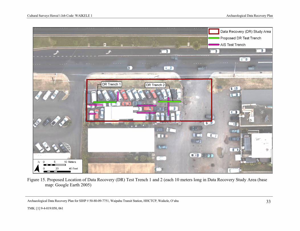
Cultural Surveys Hawai‘i Job Code: WAIKELE 1 Archaeological Data Recovery Plan
Archaeological Data Recovery Plan for SIHP # 50-80-09-7751, Waipahu Transit Station, HHCTCP, Waikele, O‘ahu 33TMK: [1] 9-4-019:050, 061
Figure 15. Proposed Location of Data Recovery (DR) Test Trench 1 and 2 (each 10 meters long in Data Recovery Study Area (base map: Google Earth 2005)

Cultural Surveys Hawai‘i Job Code: WAIKELE 1 Archaeological Data Recovery Plan
Archaeological Data Recovery Plan for SIHP # 50-80-09-7751, Waipahu Transit Station, HHCTCP, Waikele, O‘ahu 34TMK: [1] 9-4-019:050, 061
The recording of the stratigraphic profiles will be completed using USDA soil description observations/terminology. Sediment descriptions will include Munsell color, texture, consistence, structure, plasticity, cementation, origin of sediments, descriptions of any inclusions such as cultural material and/or roots and rootlets, and other general observations.. The lower boundary distinctiveness, which is the distance through which one soil horizon grades into another, will be recorded, as this information is important in the determination of stratigraphic events. Abrupt boundaries many times signal abrupt depositional events, such as floods, rapid erosion, or bull-dozing activity. Gradual boundaries can be evidence of stability and/or normal soil formation processes.
A photo log of all digital images associated with the project will be maintained. The photo log will include the date and the initials of the photographer, the approximate cardinal direction the photographer is facing, the subject matter of the image, and other location information (such as placement along the length of the trench). All photos will include a clear, visible photo scale and, where appropriate, a north arrow.
In the unlikely event that human skeletal remains are encountered during subsurface testing, and no such finds are anticipated, no further work will take place in the vicinity of the find, including no screening of back dirt, no cleaning and/or excavation of the burial area, and no exploratory work of any kind, unless specifically requested by the SHPD. All human skeletal remains that are encountered during the AIS fieldwork will be handled in compliance with HRS Chapter 6E-43 and HAR Chapter 13-300, and in consultation with SHPD.
4.3 Sample Collection and Associated Laboratory Analysis
4.3.1 Bulk Screened Samples Two 5-liter bulk samples, one from each trench, will be collected from Stratum II. These bulk
samples will be screened in the field through 1/8-inch mesh screens to recover artifacts, midden (shell and bone), and charcoal/wood samples. If subsurface features are exposed in the trench walls, additional bulk samples from the features may be collected.
CSH will conduct laboratory analysis of artifacts and faunal remains recovered in excavation units following standard archaeological practices. Vertebrates and invertebrates will be identified to the lowest taxonomic level possible. Results of the vertebrate analysis will be reported by counts (Number of Identified Specimens, or NISP) and by weight (grams). Invertebrates will be reported by weight only.
If wood charcoal fragments of sufficient size for identification are recovered, CSH will send a limited number of samples to Gail Murakami of the Wood Identification Laboratory at International Archaeological Research Institute, Inc., in Honolulu, for taxonomic identification. The samples will be compared with anatomical characteristics of known woods in the Pacific Islands Wood Collection at the Department of Botany, University of Hawai‘i, and published descriptions. The identifications may provide important data regarding the age and depositional history of the sediments. Wood charcoal identification is also a necessary component of radiocarbon dating. Should wood charcoal be used for such a purpose, in order to avoid the “old wood” problem, only charcoal from identified short-lived “native” (indigenous or Polynesian introductions) plant species will be used (see Dye 1999:2).

Cultural Surveys Hawai‘i Job Code: WAIKELE 1 Archaeological Data Recovery Plan
Archaeological Data Recovery Plan for SIHP # 50-80-09-7751, Waipahu Transit Station, HHCTCP, Waikele, O‘ahu 35TMK: [1] 9-4-019:050, 061
When a plant dies or ceases to grow, the 14C (Carbon-14) begins to decline; radiocarbon analysis can date the rate of decay and determine the time when the plant died. However, there can be a significant time lag between when a long-living plant species dies and when the wood from the species was used and/or burned.
A long-living tree may have an inner core, the heartwood, which no longer grows, while the outer portion of the tree, called the sapwood, is still alive and growing. Therefore, radiocarbon dates for wood charcoal from the heartwood and from different areas of the sapwood from the same tree may vary by many years, as radiocarbon analysis dates the time of the last growth of that portion of the tree (Gill 2000:215).
The wood of long-living species also decays slowly, and wood from tree trunks, wooden artifacts, water-logged trunks of native Hawaiian trees that are buried in sand dunes, or waterlogged driftwood that originated as far as the Pacific Northwest, may be preserved for years, or even centuries, after the death of the original tree. This “old wood” could be collected and burned by the Hawaiians. Since radiocarbon analysis dates the moment that the plant stopped growing, and not when the wood was burned, the dating of “old wood,” may provide erroneous early dates for stratigraphic layers with wood charcoal from long-lived species. To avoid this problem, wood from short-lived species, with stems or wood that decays quickly, should be used for all radiocarbon wood charcoal dating. As the wood from these species decays quickly, this indicates that the lag time between when the plant died and when it was burned must be short (Dye 1999:2).
Following analysis, the bulk materials will be returned to CSH.
4.3.2 Column and Core Samples Palynology is the branch of science concerned with the study of pollen, spores, phytoliths,
and other palynomorphs. Palynomorphs are often preserved in sediment samples and, following physical and chemical extraction, can be identified with a microscope. This information informs on the types of plants that made up the local environment at the time the sediment was deposited. A large amount of palynological research has been conducted on O‘ahu (e.g. Athens 1997; Athens and Ward 1993; 1997; Athens et al. 1992), and in Hawai‘i (e.g. Burney et al. 2001; Denham et al. 1999), to examine human impacts on native vegetation. This research has documented the substantial impact that humans have had on pre-human Hawaiian ecosystems. The currently proposed study will contribute to this literature.
Two column samples will be collected for palynological analysis, one from each trench. These samples will be sent to the Paleo Research Institute, Inc. for laboratory analysis. Dr. Laura Scott Cummings of the Paleo Research Institute suggests samples be collected in either aluminum foil or curation grade paper, but not in plastic bags or containers, which can mask other geochemical signals that we would like to be able to document. No plastic tools should be used to collect the bulk samples. Ideally, samples should weigh approximately 30 grams, particularly for palynological work. Location of column samples will be photographed and marked on the scaled trench profile field sketches. Sample weight in grams will be recorded on the feature form.
In addition, sediment cores will be collected from the base of each trench into the portion of Stratum II below the water table. Sediment cores will be collected using a Livingston piston

Cultural Surveys Hawai‘i Job Code: WAIKELE 1 Archaeological Data Recovery Plan
Archaeological Data Recovery Plan for SIHP # 50-80-09-7751, Waipahu Transit Station, HHCTCP, Waikele, O‘ahu 36TMK: [1] 9-4-019:050, 061
corer with a 7 cm diameter tube. The Livingston piston corer is a manually driven cylindrical corer designed to recover intact, stratigraphically undisturbed sediment columns from wetland and lake environments (see Wright et al. 1965, 1984). To prevent sample contamination, the tubes will be cleaned between the collection of each sediment core. In the field, cores will be extruded from the corer into cellophane-lined PVC core cases. These cases will be sealed and marked with the orientation of the core and the core’s provenience. Detailed stratigraphic descriptions will be made and sediment samples collected from the cores back at the CSH laboratory. As warranted based coring results, samples will be selected from these cores for detailed analysis.
Micro charcoal particle quantification will accompany the palynological work and will be completed by Paleo Research Institute, Inc. Although some charcoal can be created through natural events, such as fires caused by lightning, there is an increase in the amount of charcoal in soils associated with the human occupation of the Hawaiian Islands. As population increased in the Hawaiian Islands, new agricultural fields were cleared by burning the native forest (Athens 1997:248). The size and amount of these charcoal particles within a sediment sample can inform on the level of human activity in the vicinity at the time the sediment was deposited. The appearance of charcoal particles in the sediment core may also serve as an indicator of the initial settlement of the Pearl Harbor area and the surrounding watershed.
4.3.3 Radiocarbon Dating Beta Analytic, Inc. will perform radiocarbon dating. As appropriate, organic sediments,
charcoal particles, macrobotanical remains, or other carbon samples will be submitted for dating analysis. The reported conventional radiocarbon ages will be calibrated into calendar date ranges (AD/BC) using the Oxcal Calibration Program, version 3.9, developed by the Oxford Radiocarbon Accelerator Unit (ORAU) and available as share-ware over the internet. This calibration program provides probability estimates for the most likely date range(s) from radiocarbon dates that intercept the calibration curve at multiple points.
4.4 Data Recovery Report Production In compliance with HAR 13-278-4 (a), the final data recovery report will contain the
following:
1. An in-depth management summary that presents concise information including information about the site(s) studied and general findings relevant to research objectives;
2. An introduction, including reasons for conducting research and the location of the project area. A standard topographic map, as produced by the U.S. Geological Survey, shall be used to delineate the project area and the site(s) investigated. The introduction will include text that specifies the ahupua‘a, district, island, and Tax Map Key (TMK) of the project parcel;
3. An in-depth presentation of the research questions incorporating prior archaeological and historic studies in the Pearl Harbor area and research at other wetland environments in the Hawaiian Islands.
Cultural Surveys Hawai‘i Job Code: WAIKELE 1 Archaeological Data Recovery Plan
Archaeological Data Recovery Plan for SIHP # 50-80-09-7751, Waipahu Transit Station, HHCTCP, Waikele, O‘ahu 37TMK: [1] 9-4-019:050, 061
4. An archaeological field methods section which identifies the date the work was performed and the number of personnel assigned to the investigation, with names and qualifications of the principal investigator and field director. The field methods will also specify any deviations from the data recovery plan, including sampling strategies and techniques used;
5. Scale maps of sediment profiles and any other features exposed by trench excavations and cores,
6. A section on radiocarbon analysis methodology and reported results,
7. A section on sediment textural analysis, paleolimnology, and palynology analysis. The palynomorph analysis will include identification of pollen and spores, and counts of micro-charcoal particles. This information will be explained in the text, and also presented in the form of tables and graphs,
8. A separate section on any other types of cultural material found, possibly including historic trash (i.e. glass bottles), traditional Hawaiian artifacts, (i.e. fish hooks or other fishing gear), macro-wood particles, marine or terrestrial shell, and vertebrate bone,
9. A summary chapter which re-evaluates the findings relative to each research question and reviews and analyzes earlier data collected during the inventory survey,
10. References,
11. Appendices:
Beta Analytic Radiocarbon Sheets
Palynomorph Report by a qualified analyst
Other specialized analysis, such as fossilized shell analysis, or vertebrate bone analysis, if appropriate.
An end of field work letter will be submitted within 30 days of the fieldwork’s completion to the SHPD, the City, FTA, and PB. A draft of the data recovery report will be submitted to PB, the City, and FTA for review within 10 to 12 weeks of the completion of the data recovery fieldwork. Once FTA and the City are satisfied with the draft data recovery report, the report will be submitted to SHPD for their concurrence with the content of the data recovery report and the successful implementation of this data recovery program. SHPD will have 30 days to comment on the data recovery report. A final report shall then be produced, incorporating any recommended revisions as agreed upon by all reviewing parties.
With SHPD’s approval, the start of construction at the Waipahu Transit Center Makai will not need to await SHPD’s review and approval of the complete data recovery report. Under HAR Chapter 13-275-9(d) the City and FTA can provide documentation to SHPD that the data recovery fieldwork has been successfully completed and ask for SHPD’s concurrence that, with the understanding that that the complete data recovery report is forthcoming, construction can start at the data recovery site. Based on this documentation, SHPD has 30 days to concur with the City/FTA’s request.
Cultural Surveys Hawai‘i Job Code: WAIKELE 1 Archaeological Data Recovery Plan
Archaeological Data Recovery Plan for SIHP # 50-80-09-7751, Waipahu Transit Station, HHCTCP, Waikele, O‘ahu 38TMK: [1] 9-4-019:050, 061
4.5 Disposition of Collections Upon conclusion of the project, all collected materials and associated records will be
temporarily curated at the CSH office in Waimānalo, O‘ahu until a permanent curation facility is determined by the project proponents and SHPD. In compliance with the project’s Programmatic Agreement, Stipulation III.F “Curation,” the City will curate recovered materials in accordance with applicable laws, including HAR Chapter 13-278 and 36 C.F.R. 79. The project proponents are currently developing a curation program that will include the collection generated by this data recovery program.
In the event that human remains are encountered, the temporary disposition of human skeletal remains and associated burial goods will be determined by the SHPD Burials Program. Final disposition will be determined per the procedures of HAR Chapter 13-300 through the actions and decisions of the SHPD Burials Program.

Cultural Surveys Hawai‘i Job Code: WAIKELE 1 References Cited
Archaeological Data Recovery Plan for SIHP # 50-80-09-7751, Waipahu Transit Station, HHCTCP, Waikele, O‘ahu 39TMK: [1] 9-4-019:050, 061
Section 5 References Cited Alexander, W. D.
1873 Map of Honouliuli, Oahu. Map by W. D. Alexander. Registered Map No. 405. On file at the Hawai‘i Land Survey Division, Department of Accounting and General Services, 1151 Punchbowl St., Room 210, Honolulu.
Allen, Jane, Mary Riford, Thecla M. Bennett, Gail M. Murakami, Marion Kelly 1987 Five Upland ‘Ili: Archaeological and Historical Investigations in the Kāne‘ohe
Interchange, Interstate Highway H-3, Island of Oahu. Report 87-1. Department of Anthropology, Bernice Pauahi Bishop Museum, Honolulu. Hawai‘i.
Athens, J. Stephen 1997 Hawaiian native lowland vegetation in pre-history. In: P. V. Kirch and T. L. Hunt,
(Editors) Historical Ecology in the Pacific Islands. pp. 248-270. Yale University Press, New Haven, Connecticut.
Athens, J. S., and J. V. Ward 1993 Environmental change and prehistoric Polynesian settlement in Hawai‘i. Asian
Perspectives 32: 205-223. 1997 The Maunawili Core: Prehistoric Inland Expansion of Settlement and Agriculture,
O‘ahu, Hawai‘i. Hawaiian Archaeology 6: 37-52. Athens, J. S., J. V. Ward, and S. Wickler
1992 Late Holocene lowland vegetation, O‘ahu, Hawai‘i. New Zealand Journal of Archaeology 14: 9-34.
Bishop, S. E. 1889 Map Showing the Makai Part of the Ahupuaa of Waikele, Ewa, Oahu. Map by S.
E. Bishop. Traced by C. K. Tanonaka August 1951. Registered Map No. 1498. On file at the Hawai‘i Land Survey Division, Department of Accounting and General Services, 1151 Punchbowl St., Room 210, Honolulu.
Blinn, Dean 1995 Diatoms, IN, J. S. Athens, J. V. Ward, and D. W. Blinn, Palaeoenvironmental
Investigations at ‘Uko‘a Pond, Kawailoa Ahupua‘a, O‘ahu, Hawai‘i, pp. 97-121. International Archaeological Research Institute Inc., Honolulu.
Bruggencate, Jan K. Ten 2004 Hawai‘i’s Pineapple Century. A History of the Crowned Fruit in the Hawaiian
Islands. Mutual Publishing, Honolulu. Burney, David A., Helen F. James, Lida P. Burney, Storres Olson, William Kikuchi, Warren Wagner, Mara Burney, Deirdre McCloskey, Delores Kikuchi, Frederick Grady, Reginald Gage II and Robert Nishek
2001 Fossil Evidence for a Diverse Biota from Kaua‘i and its Transformation since Human Arrival. Ecological Monographs 71(4) 2001 pp. 615-641. Ecological Society of America.

Cultural Surveys Hawai‘i Job Code: WAIKELE 1 References Cited
Archaeological Data Recovery Plan for SIHP # 50-80-09-7751, Waipahu Transit Station, HHCTCP, Waikele, O‘ahu 40TMK: [1] 9-4-019:050, 061
Crumley, C. L. (ed.) 1994 Historical Ecology: A Multidimensional Ecological Orientation. IN, Historical
Ecology: Cultural Knowledge and Changing Landscapes, edited by C. L. Crumley. School of American Research Press, Santa Fe, New Mexico.
Denham, Tim, Francis J. Eble, Barbara Winsborough, and Jerome V. Ward 1999 Palaeoenvironmental and Archaeological Investigations at ‘Ohi‘apilo Pond,
Leeward Coast of Moloka‘i, Hawai‘i. Hawaiian Archaeology 7: 35-59. Chinen, Jon J.
1958 The Great Mahele: Hawaii's Land Division of l848. University of Hawai‘i Press, Honolulu.
Coletta, Paolo (editor) 1985 United States Navy and Marine Corps Bases, Domestic. Greenwood Press,
Westport, Connecticut. Conyers, Lawrence B.
2004 Ground-Penetrating Radar for Archaeology. AltaMira Press, Walnut Creek, California.
Cordy, Ross 1996 The Great ‘Ewa Lands of La'akona 1840-1850 Settlement Patterns in the 'Ewa
Lands Located Around Pearl Harbor: A Look at where Houses, Irrigated Taro Fields, Fishponds, and other Types of Sites were Located. Department of Land and Natural Resources, State Historic Preservation Division, Kapolei, Hawai‘i.
1997 Māhele Era Settlement Patterns of Waikele Ahupua‘a, ‘Ewa District, O‘ahu. Department of Land and Natural Resources, State Historic Preservation Division, Kapolei, Hawai‘i.
Denham, Tim, Francis J. Eblé, Barbara Winsborough, and Jerome Ward 1999 Palaeoenvironmental and Archaeological Investigation at ‘Ōhi‘apilo Pond,
Leeward Coast of Moloka‘i, Hawai‘i. Hawaiian Archaeology 7: 35-60. Dye, Tom
1999 Effects of 14C Sample Selection in Archaeology: An Example from Hawai‘i. International Archaeological Research Institute, Honolulu, Hawai‘i. Paper available online at http://www.tsdye.com/research/c14bellows/bel.html.
Foote, Donald E., E. L. Hill, S. Nakamura, and F. Stephens 1972 Soil Survey of the Islands of Kaua‘i, O‘ahu, Maui, Molokai, and Lanai, State of
Hawaii. U.S. Department of Agriculture, U.S. Government Printing Office, Washington D.C.
Fornander, Abraham 1918 Legend of Palila. In, Fornander Collection of Hawaiian Antiquities and Folklore
Vol. V, Part I:142-143. Memoirs of the Bernice P. Bishop Museum, Bishop Museum Press, Honolulu.
1919 Story of Palila. In, Fornander Collection of Hawaiian Antiquities and Folklore Vol. V, Part II:373-375. Bernice P. Bishop Museum, Bishop Museum Press, Honolulu.

Cultural Surveys Hawai‘i Job Code: WAIKELE 1 References Cited
Archaeological Data Recovery Plan for SIHP # 50-80-09-7751, Waipahu Transit Station, HHCTCP, Waikele, O‘ahu 41TMK: [1] 9-4-019:050, 061
Frierson, Barbara 1972 A Study of Land Use and Vegetation Change: Honouliuli, 1790-1925,
Manuscript prepared for Graduate Seminar in Geography (750). University of Hawai‘i, Honolulu.
Gill, Richardson, B. 2000 The Great Maya Droughts: Water, Life, and Death. University of New Mexico
Press, Albuquerque, New Mexico. Hammatt, Hallett H.
2010 Archaeological Inventory Survey of Construction Phase I for the Honolulu High-Capacity Transit Corridor Project, Honouliuli, Hō‘ae‘ae, Waikele, Waipi‘o, Waiawa, and Manana Ahupua‘a, ‘Ewa District, Island of O‘ahu {TMK: [1] 9-1, 9-4, 9-6, 9-7 (Various Plats and Parcels). Cultural Surveys Hawai‘i, Inc., Kailua, Hawai‘i.
Hammatt, Hallett H., and Rodney Chiogioji 2000 Archaeological Assessment of an Approximately 2,600-ft Portion of Farrington
Highway Project between Anini Place and Waipahu Depot Road, Waikele Ahupua‘a, ‘Ewa District, Island of O‘ahu, (TMK 9-4-11). Cultural Surveys Hawai‘i, Inc., Kailua, Hawai‘i.
Handy, E. S. Craighill 1940 The Hawaiian Planter, Volume 1. His Plants, Methods and Areas of Cultivation.
Bernice P. Bishop Museum Bulletin 161, Bishop Museum, Honolulu. Handy, E. S. Craighill, and Elizabeth G. Handy
1972 Native Planters in Old Hawaii: Their Life, Lore, and Environment. Bishop Museum Bulletin 233. Bernice P. Bishop Museum, Honolulu.
Judd, Walter F. 1971 Hawaii’s Military Heritage, Polynesian to Annexation. Unpublished manuscript.
Copy on file at Cultural Surveys Hawai‘i, Kailua, Hawai‘i. Ka Loea Kālai‘āina
1899 Na Wahi Pana o Ewa. Ka Loea Kālai‘āina, June 10, 1899. Kirch, Patrick V.
1985 Feathered Gods and Fishhooks. University of Hawai‘i Press, Honolulu. 1997 Introduction: The Environmental History of Oceanic Islands. In Patrick V. Kirch
and Terry L. Hunt, eds., Historical Ecology in the Pacific Islands: Prehistoric Environmental and Landscape Change. Yale University Press, New Haven and London.
1999 Hawaiian Archaeology: Past, Present, and Future. Hawaiian Archaeology: Volume 7, Society for Hawaiian Archaeology.
Kirch, Patrick V., and Terry L. Hunt (eds.) 1997 Historical Ecology in the Pacific Islands, Prehistoric Environmental and
Landscape Change. Yale University Press, New Haven and London. McAllister, J.G.
1933 Archaeology of Oahu. Bernice P. Bishop Museum Bulletin 104, Honolulu.

Cultural Surveys Hawai‘i Job Code: WAIKELE 1 References Cited
Archaeological Data Recovery Plan for SIHP # 50-80-09-7751, Waipahu Transit Station, HHCTCP, Waikele, O‘ahu 42TMK: [1] 9-4-019:050, 061
McDermott, Matt 2001 The Historical Ecology of Coastal Kīhei, District of Kula, Maui. Unpublished
Masters Thesis: University of Hawai‘i, Honolulu. McGuire, Ka‘ohulani
2000 A Traditional Practices Assessment for the Proposed Faulkes Telescope on 1.5 Acres of the University of Hawai‘i Facility at Haleakalā, Papa‘anui Ahupua‘a Makawao District, Island of Maui (TMK 2-2-07:8). Cultural Surveys Hawai‘i,
Mauricio, Michael (editor) 1997 Waipahu: Its People and Heritage. Waipahu Centennial Committee, Waipahu,
Hawai‘i. Morgenstein, Maury
1978 Geoarchaeological Analysis of Field Remnants, Kawainui March, Kailua, Oahu. Prepared for the U. S. Army Corps of Engineers by Hawaii Marine Research, Inc., Honolulu.
Morgenstein, Maury and William C. Burnett 1972 Report 5: Geologic Observations at an Agricultural Area in Upper Makaha
Valley. In Makaha Valley Historical Project Interim Report No. 3, E. J. Ladd and D. E. Yen, editors. Number 18, Pacific Anthropological Records. Department of Anthropology, Bernice P. Bishop Museum, Honolulu.
Nedbalek, Lani 1984 Waipahu: A Brief History. Wonder View Press, Mililani, Hawai‘i.
Ohira, Rod. 1997 “Waipahu Turns 100. One Sweet Century.” Honolulu Star Bulletin, June 12,
1997. Riley, Thomas J
1975 Survey and Excavation of the Aboriginal Agricultural System. In P.V. Kirch and M. Kelly (eds.) Prehistory and Ecology in a Windward Hawaiian Valley: Halawa Valley, Molokai, pp. 79-115. Pacific Anthropological Records 24. Department of Anthropology, Bernice P. Bishop Museum, Honolulu.
Schilt, A. Rose 1980 Archaeological Investigations in Specified Areas of the Hanalei Wildlife Refuge,
Hanalei Valley, Kaua‘i. Prepared for the U. S. Fish and Wildlife Service (Hanalei, Kaua‘i) by the Department of Anthropology, Bernice P. Bishop Museum, Honolulu.
Sterling, Elspeth P., and Catherine C. Summers (comp.) 1978 Sites of O‘ahu. Bernice P. Bishop Museum, Department of Anthropology,
Honolulu. Taylor, Albert P.
1922 Under Hawaiian Skies. Honolulu Advertiser Publ. Co., Honolulu. Thrum, Thomas G.
1887 Great Land Colonization Scheme. Hawaiian Almanac and Annual for 1887:73-80. Thos. G. Thrum, Honolulu.

Cultural Surveys Hawai‘i Job Code: WAIKELE 1 References Cited
Archaeological Data Recovery Plan for SIHP # 50-80-09-7751, Waipahu Transit Station, HHCTCP, Waikele, O‘ahu 43TMK: [1] 9-4-019:050, 061
1922 Hawaiian Place Names. In, A Dictionary of the Hawaiian Language, by Lorrin Andrews, pp. 625-674. Originally published in 1865. Revised by Henry Parker, 1922. Board of Commissioners of Public Archives of the Territory of Hawai‘i, Honolulu.
U.S. Department of Agriculture 1972 Soil maps from Foote, Donald E., E.L. Hill, S. Nakamura, and F. Stephens, 1972,
Soil Survey of the Islands of Kauai, Oahu, Maui, Molokai and Lanai, State of Hawaii. U.S. Dept. of Agriculture, U.S. Government Printing Office, Washington, D.C. Available online at http://www.ctahr.hawaii.edu/soilsurvey/soils.htm.
U.S. Geological Survey 1927 U.S. Geological Survey 7.5 minute topographic map of O‘ahu, Waipahu
Quadrangle. Available at USGS Information Services, Box 25286, Denver, Colorado.
1978 U.S. Geological Survey, Orthophoto (Aerial photograph). Available at USGS Information Services, Box 25286, Denver, Colorado
1998 U.S. Geological Service, Ewa, Waipahu, and Schofield Barracks Quadrangles (Aerial photograph). Available at USGS Information Services, Box 25286, Denver, Colorado.
2005 U.S. Geological Service Orthoimagery (Aerial photograph). Available at USGS Information Services, Box 25286, Denver, Colorado.
Waihona ‘Āina 2010 Mahele Database. https://www.waihona.com. Accessed January 15, 2011.
Wright, H. E., E. J. Cushing, and D. A. Livingstone 1965 Coring Devices for Lake Sediments. IN, Handbook of Paleontological
Techniques, ed. by Bernhard Kummel and David Raup, pp. 494-520. W. H. Freeman and Co., San Francisco, Calif.
Wright, H. E. Jr., D. H. Mann, and P. H. Glaster 1984 Piston Corers for Peat and Lake Sediments. Ecology 65(2):657-659.

Cultural Surveys Hawai‘i Job Code: WAIKELE 1 Appendix A
Archaeological Data Recovery Plan for SIHP # 50-80-09-7751, Waipahu Transit Station, HHCTCP, Waikele, O ‘ahu A-1TMK: [1] 9-4-019:050, 061
Appendix A SHPD Review Letter of the AIS
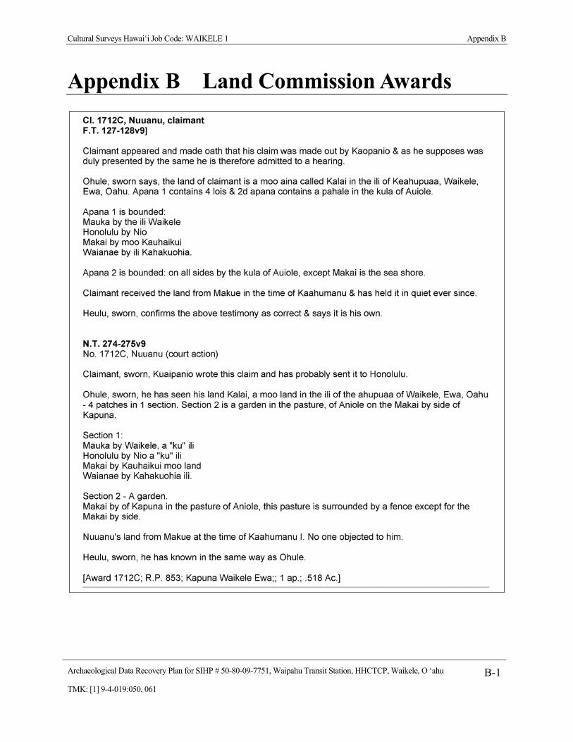
Cultural Surveys Hawai‘i Job Code: WAIKELE 1 Appendix B
Archaeological Data Recovery Plan for SIHP # 50-80-09-7751, Waipahu Transit Station, HHCTCP, Waikele, O ‘ahu B-1TMK: [1] 9-4-019:050, 061
Appendix B Land Commission Awards

Cultural Surveys Hawai‘i Job Code: WAIKELE 1 Appendix B
Archaeological Data Recovery Plan for SIHP # 50-80-09-7751, Waipahu Transit Station, HHCTCP, Waikele, O ‘ahu B-2TMK: [1] 9-4-019:050, 061