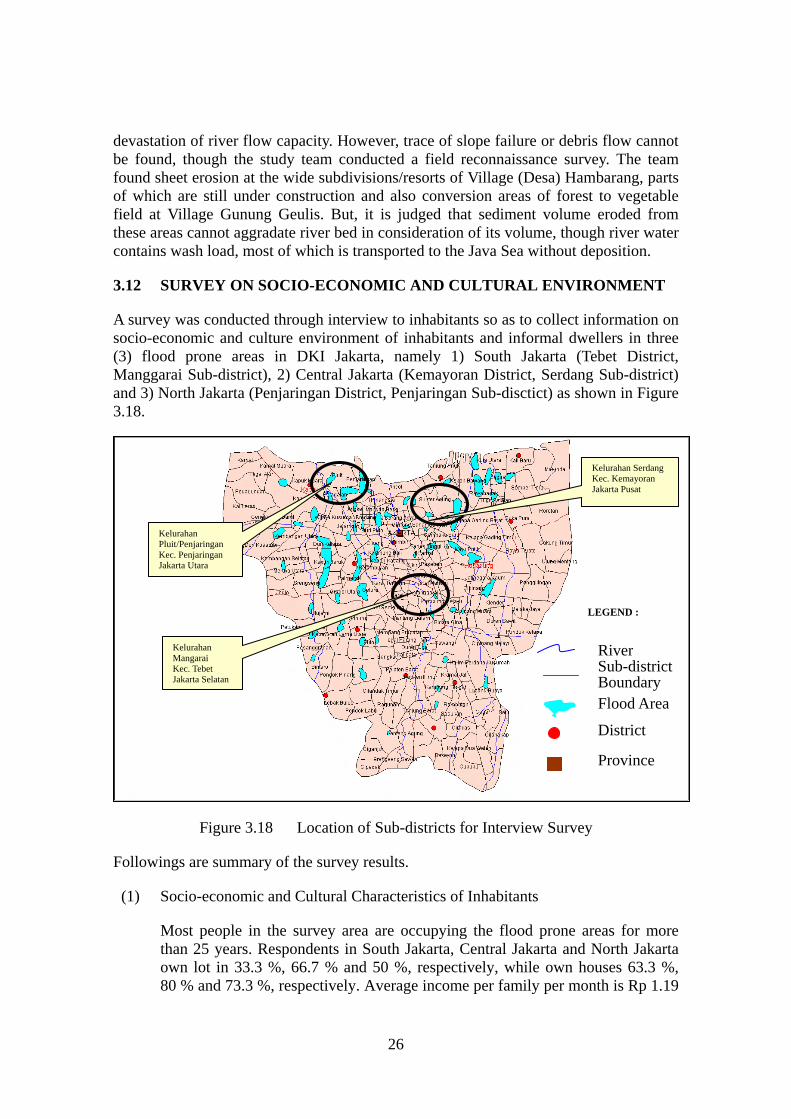
Figure 3.17 Change of Land Subsidence Rate
20
Figure 3.16 Land Subsidence between 1978 and 2002 0 1 2 3 4 5 6 1975 1980 1985 1990 1995 2000 2005 Elevation (m) NWP21 PB71 PB217 PB37 PB189 NWP17 PB384 PB166 Figure 3.17 Change of Land Subsidence Rate 3.11 SEDIMENTATION 2002 Flood Damage Study Report wrote “sediment, or soil gets into the river due to slope failure, erosion or debris flow” and concluded that this is one of the causes for 25
Transcript of Figure 3.17 Change of Land Subsidence Rate
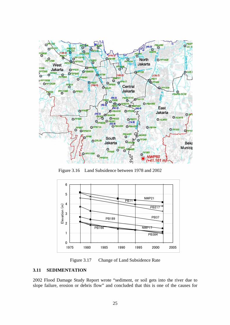
Figure 3.16 Land Subsidence between 1978 and 2002
0
1
2
3
4
5
6
1975 1980 1985 1990 1995 2000 2005
Ele
vation (
m)
NWP21PB71
PB217
PB37PB189
NWP17
PB384
PB166
Figure 3.17 Change of Land Subsidence Rate
3.11 SEDIMENTATION
2002 Flood Damage Study Report wrote “sediment, or soil gets into the river due to slope failure, erosion or debris flow” and concluded that this is one of the causes for
25
devastation of river flow capacity. However, trace of slope failure or debris flow cannot be found, though the study team conducted a field reconnaissance survey. The team found sheet erosion at the wide subdivisions/resorts of Village (Desa) Hambarang, parts of which are still under construction and also conversion areas of forest to vegetable field at Village Gunung Geulis. But, it is judged that sediment volume eroded from these areas cannot aggradate river bed in consideration of its volume, though river water contains wash load, most of which is transported to the Java Sea without deposition.
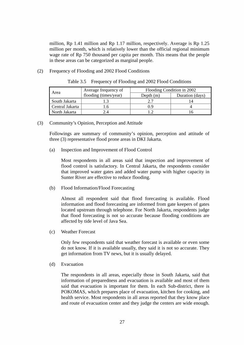
3.12 SURVEY ON SOCIO-ECONOMIC AND CULTURAL ENVIRONMENT
A survey was conducted through interview to inhabitants so as to collect information on socio-economic and culture environment of inhabitants and informal dwellers in three (3) flood prone areas in DKI Jakarta, namely 1) South Jakarta (Tebet District, Manggarai Sub-district), 2) Central Jakarta (Kemayoran District, Serdang Sub-district) and 3) North Jakarta (Penjaringan District, Penjaringan Sub-disctict) as shown in Figure 3.18.
River Sub-district Boundary Flood Area
District
Province
Figure 3.18 Location of Sub-districts for Interview Survey
Followings are summary of the survey results.
(1) Socio-economic and Cultural Characteristics of Inhabitants
Most people in the survey area are occupying the flood prone areas for more than 25 years. Respondents in South Jakarta, Central Jakarta and North Jakarta own lot in 33.3 %, 66.7 % and 50 %, respectively, while own houses 63.3 %, 80 % and 73.3 %, respectively. Average income per family per month is Rp 1.19
LEGEND :
Kelurahan SerdangKec. Kemayoran Jakarta Pusat
Kelurahan Pluit/Penjaringan Kec. Penjaringan Jakarta Utara
Kelurahan Mangarai Kec. Tebet Jakarta Selatan
26
million, Rp 1.41 million and Rp 1.17 million, respectively. Average is Rp 1.25 million per month, which is relatively lower than the official regional minimum wage rate of Rp 750 thousand per capita per month. This means that the people in these areas can be categorized as marginal people.
(2) Frequency of Flooding and 2002 Flood Conditions
Table 3.5 Frequency of Flooding and 2002 Flood Conditions
Flooding Condition in 2002 Average frequency of flooding (times/year) Area
Depth (m) Duration (days) South Jakarta 1.3 2.7 14 Central Jakarta 1.6 0.9 4 North Jakarta 2.4 1.2 16
(3) Community’s Opinion, Perception and Attitude
Followings are summary of community’s opinion, perception and attitude of three (3) representative flood prone areas in DKI Jakarta.
(a) Inspection and Improvement of Flood Control
Most respondents in all areas said that inspection and improvement of flood control is satisfactory. In Central Jakarta, the respondents consider that improved water gates and added water pump with higher capacity in Sunter River are effective to reduce flooding.
(b) Flood Information/Flood Forecasting
Almost all respondent said that flood forecasting is available. Flood information and flood forecasting are informed from gate keepers of gates located upstream through telephone. For North Jakarta, respondents judge that flood forecasting is not so accurate because flooding conditions are affected by tide level of Java Sea.
(c) Weather Forecast
Only few respondents said that weather forecast is available or even some do not know. If it is available usually, they said it is not so accurate. They get information from TV news, but it is usually delayed.
(d) Evacuation
The respondents in all areas, especially those in South Jakarta, said that information of preparedness and evacuation is available and most of them said that evacuation is important for them. In each Sub-district, there is POKOMAS, which prepares place of evacuation, kitchen for cooking, and health service. Most respondents in all areas reported that they know place and route of evacuation center and they judge the centers are wide enough.
27
But, the problems are no bed for sleeping and shortage of drinking water and toilet.
Regarding North Jakarta, more than half of respondents do not evacuate during flood time, because almost all area is covered by water. They stay on the second floor or on the roof during flood time.
(e) Willingness to Participate
Almost all respondents said that flood mitigation activities are mostly under responsibility of the provincial government and thus willingness to participate in flood mitigation activities is low except for Central Jakarta.
(f) Rescue Effort
The rescue effort in South Jakarta and Central Jakarta is high, while in North Jakarta is low. The low rescue effort in North Jakarta is due to the flooding conditions of the place, in which during flood time all areas are covered by water.
(g) Need and Willingness to Relocation
More than half of respondents in North and South Jakarta intend to be relocated, while percentage of respondents, who want to be relocated in Central Jakarta is only 23 %. Most respondents want to be relocated to areas without flooding, while the reasons why they do not want to be relocated are; 1) they do not know where to move and 2) they can get income easily in or nearby places they live at present.
(h) Improvement of River Environment
In South Jakarta and North Jakarta, respondents said that improvement of river environment is not satisfactory, while in Central Jakarta is the opposite. In Central Jakarta, people think that government is fully responsible for the improvement of river environment, while the respondents of two (2) other areas think none is responsible for the river environment.
3.13 NGOS IN DKI JAKARTA
Flooding in the year of 2002 totally damaged the JABOTABEK, particularly the DKI Jakarta, and left problems unsolved for long time in such fields of rescue/rehabilitation including health, environment, employment and so on. The activities of rescue/rehabilitation cannot be done only by governmental organizations on tremendous disasters like the 2002 flood event and thus, survey of NGO was conducted in this study. In JABOTABEK, there are 193 NGOs. The list of these NGOs including activities, address and contact persons are so prepared that rescue and rehabilitation activities can be timely and fruitfully implemented through cooperation with them.
28

4. FLOOD EVENT IN THE YEAR OF 2002
4.1 2002 FLOOD EVENT
4.1.1 FLOOD DAMAGE
In the year of 2002, the JABOTABEK suffered from tremendous flood damages from Jan. 26th to Feb. 20th. According to the 2002 Flood Damage Study, inundation area was 526 km2 or equivalent to 8.6% of total area of JABOTABEK (Figure 4.1). Out of them, areas, where flooding depth exceeded 0.5 m for more than 1 week, totaled 53 km2 or 0.86%.
Figure 4.1 Flooded Area in 2002 Flood Event
Flooded urban area reached around 87.1 km2 in DKI Jakarta and 15.2 km2 in municipalities of Tangerang, Bekasi and Depok. Figure 4.2 shows flooding conditions of central portions of DKI Jakarta. Most of the low land in the pump drainage areas was inundated.
Due to deep and continuous flooding, 380 thousand persons were forced to be evacuated, while number of casualties was more than 30 persons according to the news papers.
29

Figure 4.2 Flooding Conditions in Pump Drainage Areas in 2002 Flood Event
4.1.2 RAINFALL
32.7
168.5
45.2 24.016.640.030.0
103.9
Figure 4.3 Daily Rainfall Distribution in 2002 Flood Event
0
50
100
150
200
250
300
26-27 Jan.27-28 Jan.28-29 Jan.29-30 Jan.30-31 Jan.31- 1 Feb1-2 Feb.2-3 Feb.
Dai
ly R
ainf
all (
mm
)
2
250
108
9
84
264572
0
50
100
150
200
250
300
26-27 Jan.27-28 Jan.28-29 Jan.29-30 Jan.30-31 Jan.31- 1 Feb1-2 Feb.2-3 Feb.
Dai
ly R
ainf
all (
mm
)
02027 Jakarta Pusat 8TP Bekasi
63
148 150
14 015
89
47
0
50
100
150
200
250
300
26-27 Jan.27-28 Jan.28-29 Jan.29-30 Jan.30-31 Jan.31- 1 Feb1-2 Feb.2-3 Feb.
Dai
ly R
ainf
all (
mm
)
9TP Depok
55.214.7
49.3
0.0
23.2
72.285.0 84.6
0
100
150
200
250
300
26-27 Jan.27-28 Jan.28-29 Jan.29-30 Jan.30-31 Jan.31- 1 Feb1-2 Feb.2-3 Feb.
Dai
ly R
ainf
all (
mm
)
50
02032C
30
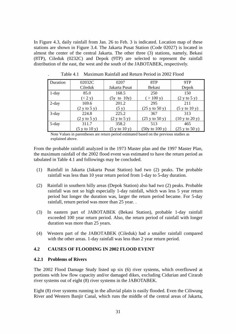
In Figure 4.3, daily rainfall from Jan. 26 to Feb. 3 is indicated. Location map of these stations are shown in Figure 3.4. The Jakarta Pusat Station (Code 02027) is located in almost the center of the central Jakarta. The other three (3) stations, namely, Bekasi (8TP), Cileduk (0232C) and Depok (9TP) are selected to represent the rainfall distribution of the east, the west and the south of the JABOTABEK, respectively.
. Table 4.1 Maximum Rainfall and Return Period in 2002 Flood
Duration 02032C Cileduk
0207 Jakarta Pusat
8TP 9TP Bekasi Depok
1-day 85.0 168.5 (5y to 10y)
250 150 (< 2 y) ( > 100 y) (2 y to 5 y)
2-day 169.6 201.2 295 211 (2 y to 5 y) (5 y) (25 y to 50 y) (5 y to 10 y)
3-day 224.8 225.2 367 313 (2 y to 5 y) (2 y to 5 y) (25 y to 50 y) (10 y to 20 y)
5-day 311.7 358.2 513 465 (5 y to 10 y) (5 y to 10 y) (50y to 100 y) (25 y to 50 y)
Note Values in parentheses are return period estimated based on the previous studies as explained above.
From the probable rainfall analyzed in the 1973 Master plan and the 1997 Master Plan, the maximum rainfall of the 2002 flood event was estimated to have the return period as tabulated in Table 4.1 and followings may be concluded.
(1) Rainfall in Jakarta (Jakarta Pusat Station) had two (2) peaks. The probable rainfall was less than 10 year return period from 1-day to 5-day duration.
(2) Rainfall in southern hilly areas (Depok Station) also had two (2) peaks. Probable rainfall was not so high especially 1-day rainfall, which was less 5 year return period but longer the duration was, larger the return period became. For 5-day rainfall, return period was more than 25 year. .
(3) In eastern part of JABOTABEK (Bekasi Station), probable 1-day rainfall exceeded 100 year return period. Also, the return period of rainfall with longer duration was more than 25 years.
(4) Western part of the JABOTABEK (Cileduk) had a smaller rainfall compared with the other areas. 1-day rainfall was less than 2 year return period.
4.2 CAUSES OF FLOODING IN 2002 FLOOD EVENT
4.2.1 Problems of Rivers
The 2002 Flood Damage Study listed up six (6) river systems, which overflowed at portions with low flow capacity and/or damaged dikes, excluding Cidurian and Cirarab river systems out of eight (8) river systems in the JABOTABEK.
Eight (8) river systems running in the alluvial plain is easily flooded. Even the Ciliwung River and Western Banjir Canal, which runs the middle of the central areas of Jakarta,
31

have low flow stretches and bottle neck portions. Flooding occurred at these stretches and portions during the 2002 flood event, rainfall of which had a return period less than 10-year.
In order to upgrade the safety level of these rivers, master plan studies were conducted for DKI Jakarta in 1973 and for JABOTABEK in 1997. However, improvement plans have not been materialized except for the Eastern Banjir Canal, the construction of which is ongoing at present.
It is clear that the main cause of flooding is attributable to delay of implementation of flood control projects to upgrade safety level of eight (8) river systems. Overflowed water flowed into the low-lying areas including the pump drainage areas of the DKI Jakarta, which were originally back swamp and used as paddy field. Flooding in back swamp naturally tends to be long and furthermore, drainage system in these areas has problems as explained in 4.3.2. In addition, delay of maintenance or rehabilitation of damaged portions of rivers may have increased flood damages.
4.3.2 Problems of Drainage System
In the 1973 Master Plan, two (2) methods were mainly proposed after protecting the central area of the Jakarta by the WBC and the EBC; 1) Usage of existing rivers as main drains, and 2) Pump drainage by dividing low-lying areas into several drainage areas. Following this plan, improvement of main drains and installation of pumps have been implemented to drain a design flood of 25-year return period.
However, the pump drainage areas were seriously affected during the 2002 flood event. One of the main causes of serious flooding in drainage areas is inflow of overflowed water from the rivers as explained above and opening of Ciliwung-Manggarai Gate at the Ciliwung Drain so as to avoid gate damage/destruction due to overflow.
Regarding the drainage systems, followings may be possible causes of serious flooding, which cannot be confirmed due to lack of data at present.
(1) Combination of Pump Capacity and Storage Volume of Reservoir
If reservoir may not yet be empty before the second peak of rainfall of the 2002 flood event, small pump capacity is a cause of flooding and pump capacity needs to be increased to drain the similar rainfall pattern.
(2) Increase of Planned Pump Drainage Area
Pump capacity may not be enough, if rainwater outside of the planed drainage area flows into and to be drained by the pump, because gravity drain outside of the pump drainage area cannot be made due to high tide or influence of possible land subsidence.
(3) Improper Secondary and Tertiary Drains
32

PMain drain
Secondary drain
Secondary drain
Floodedarea
Floodedarea
Floodedarea
Flow of flooded water
Reservoir
Pump drainage area
Figure 4.4 Flooding due to Improper Secondary/Tertiary Drain
Figure 4.5 Flow of Flooded Water to Lower Areas
Pump capacity and pump starting water level of the reservoir are so determined that maximum water level of the main drain of the drainage area does not exceed the bank height of the main drain for one day flood with 25-year return period.
To determine the pump capacity and pump starting water level, no consideration was given to the existing secondary and tertiary drains, assuming that most of the rain water in the drainage area can be collected to the main drain.
During the 2002 flood event, the followings may occur. Rain water started to flood in low areas in the respective drainage areas. However, flooded water could not be drained to the main drain due to improper secondary and tertiary drains. Thus, flooded water gradually increased its areas and depth and then started to flow to the lower areas in the same drainage area or in the continued different drainage area.
Finally, flooded water flowed to the lowest areas such as the coastal areas. Again, due to the problems of secondary/tertiary drains, it took long duration to drain the flooded water through the pumps.
33

4.3.3 Problems of Preparedness
In the flood operation manuals for both of the CILCIS and the DKI Jakarta, one flood risk map is attached (Figure 3.25). This map explains 78 flood prone areas, which are likely to occur every year. Figure 4.9 compares actual flooded areas in 2002 flood shown in (a) and those indicated in flood risk map shown in (b), mainly concentrating in the pump drainage areas and west portions of DKI Jakarta.
(a) Flooded Area in 2002 Flood (b) Flood Risk Map
Figure 4.6 Comparison of Flooded Area in 2002 and Flood Risk Map
This difference in flooded areas may cause problems in preparedness as explained below, since it is hard to recognize for the related persons/organizations that flooding may occur outside of the flood prone areas shown in flood risk map, corresponding to the volume and pattern of rainfall, particularly as time goes on after the 2002 flood event.
(1) POKOMAS in Sub-districts and RWs/RTs outside of the flood prone areas (Figure 3.25) may not well organized and not prepare for water monitoring, evacuation centers, evacuation route and so on.
(2) Operators of gates/pumps and water level monitoring units in upper streams and the DKI Jakarta may not inform flood information including Flood Alerts to Sub-districts outside of the flood prone areas shown in flood risk map.
4.3.4 Other Problems
The 2002 Flood Damage Study concluded several causes of flooding. Followings are results/comments of this Study on these causes of flooding.
(1) Maintenance of Rivers and Drainage Structures
Lack of maintenance of the flood control and drainage structures might be one of
34

the causes, since the CILCIS and the DKI Jakarta do not have necessary data to conduct maintenance activities as well as maintenance records. Data necessary for maintenance are cross-sectional survey of rivers and drains as well as inventory of the flood control and drainage structures under their responsibility, such as dikes, levees, groundsills, gates and so on. Based on these data, change of cross sections, reduction of flow capacity and damage of structures can be analyzed in more detail in connection with the causes of flooding. Therefore, timing of dredging and design depth is hard to be decided without records of cross-sectional change. Also prioritization of maintenance activities for flood control and drainage structures cannot be made without inventory and evaluation of damage.
(2) Operation of Pump and Gates
Operation procedures of pumps and gates are explained in detail in the flood operation manuals for both of the CILCIS and the DKI Jakarta. When the water level of the monitoring water level gauging stations reaches/enters to the Alert IV water levels, information for preparation is issued and notified to the related pumping and gate stations. And when the water level of a river/drain rises to the predetermined water level, the corresponding pumps and/or gates are operated following the manuals.
Judging from information flow and contents of operation procedures described in the manuals, problems cannot be found on operation of gates and pumps. However, water level for operation may be necessary to be revised based on the change of flow capacity of rivers/drains, when cross-sectional survey of the rivers/drains is conducted and flow capacity is newly estimated.
(3) Sedimentation
According to the 2002 Flood Damage Study Report, sediment/soil, which gets into the river due to slope failure, erosion or debris flow was one of the causes for devastation of river flow capacity. However, trace of slope failure or debris flow cannot be found, though the team conducted a field reconnaissance survey. Sheet erosion is occurring but these cannot be cause of aggradation in consideration of erosion volume, though river water contains wash load which flows to the sea.
35

5. PROBLEMS AND ISSUES ON FLOOD DAMAGE MITIGATION IN JABOTABEK
5.1 PRESENT SITUATION
Northern area of DKI Jakarta and also Northern area of JABOTABEK along Java Sea are low-lying flood prone areas, where a lot of rivers are running from mountainous southern areas to the Java Sea. To tackle flooding problems, the Government of Indonesia has formulated a drainage and flood control Master Plan in 1973. Then, a new flood control master plan was formulated in 1997, target area of which is not only DKI Jakarta, but also covers the developing JABOTABEK area. However, flood control plan proposed in the master plans has not been materialized due to difficulty in land acquisition, except for the Easter Banjir Canal, which is under construction at present. Regarding drainage system, based on the 1973 master plan, lowland of DKI Jakarta has been divided into drainage areas, in which construction of pumping stations and improvement of main drains have been implemented with the design scale of 25-year return period.
From late January to mid-February 2002, low-lying areas of JABOTABEK suffered from tremendous flood damages, particularly, most drainage areas of the DKI Jakarta were deeply submerged for long duration. The return period of rainfall during the 2002 flood event may be approximately 10 year in Jakarta, though that in Bekasi may reach to 100 year. Rivers flowing in the JABOTABEK overflowed at lot of places of low flow capacity. Main cause of the serious flooding can be attributable to delay of flood control projects to improve these rivers. In addition, it can be estimated that drainage system in drainage areas composed of pumps, main drains and secondary/tertiary drains are not enough as a total system, particularly for rainfall with long duration, though capacity of pumps and main drains have been improved, intending to cope with a flood with 25-year return period scale.
It still requires a long period of time to implement flood control projects and drainage system improvement, which drastically increase safety level against flood of JABOTABEK. In addition, there is a high possibility that peak discharge of rivers is largely increased due to development of paddy fields and forest areas located in their upper basins and flood overflows from the existing rivers and drainage systems, which are hard to be upgraded in short time, thus causing much more serious flood damages in low-lying flood prone areas.
Under these circumstances, it is judged as urgently necessary to implement following measures to minimize flood damages.
(1) Preparation of inventory and execution of basic analysis
(2) Utilization of maximum capacity of existing rivers and drainage systems
(3) Encouragement of preparedness in flood prone areas
36
(4) Prevention of rapid runoff increase
5.2 NECESSARY FLOOD DAMAGE MITIGATION MEASURES
5.2.1 Preparation of Inventory and Execution of Basic Analysis
(1) Preparation of inventory database system of rivers, flood control structures and drainage structures
(2) Execution of cross-sectional survey for rivers and drains
(3) Estimation of flow capacity for rivers and drains
(4) Execution of post flood survey and analysis of causes of flooding
5.2.2 Utilization of Maximum Capacity of Existing Rivers and Drainage Systems
(1) Selection of problematic sites and Structures for Monitoring and Inspection
(2) Study of flood fighting activities including works, materials and warehouses and execution of flood fighting
(3) Study and execution of maintenance works including dredging, cleaning and repair/rehabilitation
(4) Executions of actions to illegal activities
(5) Study of operation of pumps and gates
(6) Estimation of necessary personnel and budget for maintenance and operation activities
(7) Revision of flood operation manuals
(8) Recommendation for flood control and drainage master plan
5.2.3 Encouragement of Preparedness in Flood Prone Areas
(1) Preparation of flood inundation simulation model
(2) Preparation of flood risk maps for several probable rainfall
(3) Revision of flood alert water level
(4) Establishment of a flood forecasting and warning center
5.2.4 Prevention of Runoff Increase due to Development
There are two (2) methods to prevent runoff increase. One method is to designate the areas with storage functions as conservation areas, in which development activities are
37

restricted or controlled in consideration of attainment of flood control and drainage system improvement. In the case of the JABOTABEK, most the DKI Jakarta has designated and actually developed as housing area and industrial areas, while in the Bogor Regency, 38 % of the total area has been designated as new built-up areas, which were previously forest areas, in addition to the existing built-up areas.
The other method is to install a lot of retention and/or permeable facilities to minimize increase of runoff discharge. Considering further increase of discharge and difficulty in widening/new construction of rivers, it is necessary to explain to stakeholder about increase of flood damages due to development and to take actions so as to install retention/permeable facilities, in addition to conservation of the remaining forest and open space as well as small lakes/ponds (Situ-situ).
Followings may be applicable retention/permeable facilities in JABOTABEK.
Retention pond particularly for large scale subdivision, which stores increased portion of runoff due to development
Retention at park, school, sport ground, tennis court, parking lot, space between buildings/apartments, roof, etc.
Permeable pavement, which enables infiltration, at the place groundwater level is low and ground slope is not steep.
5.3 STEPWISE IMPLEMENTATION PLAN FOR FLOOD DAMAGE MITIGATION MEASURES
Flood mitigation measures proposed above may be implemented in two (2) phases as explained below.
5.3.1 1st Phase
(1) Rivers (Flood Control)
(a) Preparation of Inventory and Execution of Basic Analysis
(i) Preparation of inventory database system of rivers and flood control structures
(ii) Execution of cross-sectional survey
(iii) Estimation of flow capacity
(iv) Execution of post flood survey
(b) Utilization of Maximum Capacity of Existing Rivers
(i) Selection of problematic sites and structures
38

(ii) Study and preparation of applicable flood fighting works and necessary equipment/materials
(iii) Study and preparation of maintenance activities
(iv) Study and preparation of optimum operation of pumps and gates
(v) Revision of flood operation manual
(vi) Recommendation for flood control master plan
(c) Prevention of Runoff Increase
(i) Study of applicable retention/permeable facilities from the hydrology/hydraulics, regulations, socio-economy and so on
(2) Drainage System
(a) Preparation of Inventory and Execution of Basic Analysis
(i) Preparation of inventory database system for drainage structures
(ii) Execution of cross-sectional survey
(iii) Estimation of flow capacity
(iv) Execution of flood damage survey
(b) Utilization of Maximum Capacity of Existing Drainage Structures
(i) Selection of problematic sites and structures
(ii) Study and preparation of applicable flood fighting works and necessary equipment/materials
(iii) Study and preparation of maintenance activities
(iv) Study and preparation of optimum operation of pumps and gates
(v) Revision of flood operation manual
(vi) Recommendation for drainage master plan including increase of pump capacity, improvement of secondary/tertiary drains and so on
(c) Prevention of Runoff Increase
(i) Study of applicable retention/permeable facilities from the hydrology/hydraulics, regulations, socio-economy and so on
(3) Preparedness
39

(a) Data collection for flood inundation simulation model
(b) Preparation/establishment of flood inundation simulation model
5.3.2 2nd Phase
(1) Rivers (Flood Control)
(a) Preparation of Inventory and Execution of Basic Analysis
(i) Additional data input to Inventory database system for rivers and river structures
(ii) Execution of additional cross-sectional survey for problematic stretches
(iii) Estimation of flow capacity, if necessary
(iv) Execution of flood damage survey
(b) Utilization of maximum capacity of existing rivers
(i) Implementation of monitoring, inspection and maintenance activities
(ii) Implementation of flood fighting
(c) Prevention of Runoff Increase
(i) Workshop for installation of retention/permeable facilities
(ii) Recommendation for installation of retention/permeable facilities
(2) Drainage System
(a) Preparation of Inventory and Execution of Basic Analysis
(i) Additional data input to Inventory database system for rivers and river structures
(ii) Execution of additional cross-sectional survey for problematic stretches
(iii) Estimation of flow capacity, if necessary
(iv) Execution of flood damage survey
(b) Utilization of maximum capacity of existing drainage system
(i) Implementation of monitoring, inspection and maintenance
40

activities
(ii) Implementation of optimum operation
(iii) Implementation of flood fighting
(c) Prevention of Runoff Increase
(i) Workshop for installation of retention/permeable facilities
(ii) Recommendation for installation of retention/permeable facilities
(3) Preparedness
(a) Analysis of flood inundation conditions
(b) Preparation and publication of flood risk map
(c) Revision of Flood Alerts
(d) Issuance of accurate flood information and Flood Alerts to related organizations and inhabitants
(e) Preparation for establishment of Flood Forecasting and Warning Center
41

Reference
Basic design study report on the project for improvement of pump drainage in poverty district in Jakarta, JICA (Nippon Koei Co. Ltd.), Mar. 2004
Flood Survey in DKI Jakarta, Pacific Consultant International, Feb. 2002
Interim Report Review Master Plan Ciliwung – Cisadane River Basin, Rijkswaterstaat, July 2004
Ditto, Annex I Flood Control
Land Subsidence of Jakarta Metropolitan Area, R., Djaja, J., R, H. Z. Abidin and K.Wedyanto, 2004
Law No. 7 of 2004 on Water Resources, The President of the Republic of Indonesia, August 2004
Ditto, Elucidation to Law No.7 of 2004 on Water Resources,
Master Plan for Drainage and Flood Control of Jakarta, Nedeco, Dec. 1973
Pedoman Siaga Banjir Propinsi DKI Jakrata (Flood Operation of DKI Jakarta), DPU DKI, Oct. 2004
Prosedur Operasi Lapangan Musim Hujan Tahun 2004/2005 (Flood Operation for 2004/2005), CILCIS
The Study on Comprehensive River Water Management Plan in JABOTABEK, JICA (Nikken Consultants Inc. and Nippon Koei Co., Ltd.), Mar. 1997
Urgent Inventory Study on Damage of Flood 2002 in Jabodetabek Area in Indonesia Final Report, Pt. Mitrapacific Consulindo International, May 2003
42

1. introduction......................................................................................................... 1 1.1 background ......................................................................................................... 1 1.2 objectives ............................................................................................................ 1 1.3 Study area ........................................................................................................... 2
2. present conditions ..................................................................................................... 3 2.1 socio-economic conditions ................................................................................. 3
2.1.1 Administration............................................................................................. 3 2.1.2 Population and Households ......................................................................... 4
2.2 Natural conditions .............................................................................................. 5 2.2.1 Climate ........................................................................................................ 5 2.2.2 River Systems .............................................................................................. 5
3. basic information related to flood mitigation and flooding in jabodetabek ............. 6 3.1 INSTITUTION ................................................................................................... 6
3.1.1 Water Laws and Regulations ....................................................................... 6 3.1.2 Decentralization and Autonomy .................................................................. 7 3.1.3 Organization and Functions of Flood Control and Drainage System.......... 8
3.2 Mapping.............................................................................................................. 9 3.3 Rainfall and water level observation .................................................................. 9 3.4 Flood control measures..................................................................................... 10
3.4.1 Agreement on Flood Control and Urban Drainage ................................... 10 3.4.2 Master Plan and Feasibility Study ............................................................. 10 3.4.3 Ongoing Project......................................................................................... 13 3.4.4 On-Going and Planned Study .................................................................... 13 3.4.5 Present Flood Control Facilities ................................................................ 13
3.5 Drainage system ............................................................................................... 14 3.5.1 Master Plan for Drainage and Flood Control of Jakarta (1973) ................ 14 3.5.2 Present Drainage System........................................................................... 14
3.6 Flood Operation................................................................................................ 16 3.6.1 Organization for Flood Operation ............................................................. 16 3.6.2 Flood Operation in DKI Jakarta ................................................................ 17
3.7 Solid waste management .................................................................................. 20 3.8 Land acquisition ............................................................................................... 20 3.9 Development of Jakarta and Land use planning............................................... 21
3.9.1 Development of Jakarta ............................................................................. 21 3.9.2 Spatial Planning......................................................................................... 23
3.10 Land subsidence............................................................................................ 24 3.11 Sedimentation ................................................................................................... 25 3.12 SURVEY ON SOCIO-ECONOMIC AND CULTURAL ENVIRONMENT 26 3.13 ngos in dki Jakarta......................................................................................... 28
4. flood event in the year of 2002............................................................................... 29 4.1 2002 Flood event .............................................................................................. 29 4.1.1 Flood damage................................................................................................ 29 4.1.2 Rainfall.......................................................................................................... 30 4.2 Causes of flooding in 2002 flood event............................................................ 31
4.2.1 Problems of Rivers .................................................................................... 31 4.3.2 Problems of Drainage System ................................................................... 32 4.3.3 Problems of Preparedness.......................................................................... 34
43
4.3.4 Other Problems.......................................................................................... 34 5. Problems and issues on flood damage mitigation in jabotabek.............................. 36
5.1 Present situation................................................................................................ 36 5.2 Necessary flood Damage mitigation measures................................................. 37
5.2.1 Preparation of Inventory and Execution of Basic Analysis....................... 37 5.2.2 Utilization of Maximum Capacity of Existing Rivers and Drainage Systems................................................................................................................... 37 5.2.3 Encouragement of Preparedness in Flood Prone Areas............................. 37 5.2.4 Prevention of Runoff Increase due to Development ................................. 37
5.3 Stepwise IMPLEMENTATION plan for Flood damage mitigation measures . 38 5.3.1 1st Phase ..................................................................................................... 38 5.3.2 2nd Phase .................................................................................................... 40
44


![Study of land subsidence around the city of Shirazscientiairanica.sharif.edu/article_2167_b3bb54f3fcf13e2c...tectonic subsidence, and etc. [2]. Land subsidence, as a serious crisis,](https://static.fdocuments.us/doc/165x107/5f81603bf7f7323e190f6f7c/study-of-land-subsidence-around-the-city-of-s-tectonic-subsidence-and-etc.jpg)