Figure 30 TAC §307.10(4) - · Jan 6-7, 2008 Surface Water Quality Standards Workgroup Appendix D...
22
Jan 6-7, 2008 Surface Water Quality Standards Workgroup Appendix D - Page 1 Figure 30 TAC §307.10(4) Appendix D - Site-specific Uses and Criteria for Unclassified Water Bodies [Receiving Water Assessments] (New material is underlined. Material to be deleted is in brackets []. The water bodies listed in this appendix are those waters that are not designated segments listed in Appendix A of this title. The water bodies are included because a regulatory action has been taken or is anticipated to be taken by the commission or because sufficient information exists to provide an aquatic life use designation. The segment numbers listed refer to the designated segments as defined in Appendix C of this title. The county listed is the primary location where the use designation has been assigned. The water body is a tributary within the drainage basin of the listed segment. The aquatic life use (ALU) designations and dissolved oxygen (D.O.) criterion are the same as defined in §307.4(h)[ §307.3(b)] and §307.7(b)(3)(A) of this title. The description defines the specific area for which the aquatic life use designation pertains. Recreational [ Contact recreation] uses are assigned to [ all of] the waters listed as defined in §307.4(j) . Generally, there is not sufficient data on these waters to develop other conventional criteria and those criteria are the same as for the segment in which the water body is located unless further site-specific information is obtained. SEGMENT COUNTY WATER BODY ALU D.O. DESCRIPTION 0101 Carson, Hutchinson Dixon Creek I 4.0 Intermittent stream with perennial pools from the confluence with the Canadian River in Hutchinson County upstream to the confluence of the Middle, West, and East Dixon creeks in Carson County 0101 Hutchinson Rock Creek L 3.0 Perennial stream from the confluence with the Canadian River up to SH 136 in the City of Borger 0201 Bowie Jones Creek I 4.0 Intermittent stream with perennial pools from the confluence with Barkman Creek up to the western most crossing of FM 1398 near the City of Hooks 0202 Fannin Bois d'Arc Creek I 4.0 Perennial stream from the confluence with Sandy Creek upstream to the confluence with Pace Creek 0202 Grayson Corneliason Creek L 3.0 Intermittent stream with perennial pools from the confluence with Mill Creek up to FM 1897 in the City of Bells 0202 Lamar Pine Creek I 4.0 Perennial and intermittent stream from the confluence with the Red River upstream to the dam forming Lake Crook 0203 Grayson Big Mineral Creek I 4.0 Intermittent stream with perennial pools from Lake Texoma’s normal pool elevation of 617 feet upstream to the confluence with an unnamed second order tributary on North Branch 2.4 km upstream of US 377 and upstream to the confluence with an unnamed second order tributary on South Branch 1.1 km upstream of US 377 north of the City of Whitesboro
Transcript of Figure 30 TAC §307.10(4) - · Jan 6-7, 2008 Surface Water Quality Standards Workgroup Appendix D...

Jan 6-7, 2008 Surface Water Quality Standards Workgroup Appendix D - Page 1
Figure 30 TAC §307.10(4)
Appendix D - Site-specific Uses and Criteria for Unclassified Water Bodies[Receiving Water Assessments]
(New material is underlined. Material to be deleted is in brackets []. The water bodies listed in this appendix are those waters that are not designated segments listed in Appendix A of this title. The water bodies are included because a regulatory action has been taken or is anticipated to be taken by the commission or because sufficient information exists to provide an aquatic life use designation. The segment numbers listed refer to the designated segments as defined in Appendix C of this title. The county listed is the primary location where the use designation has been assigned. The water body is a tributary within the drainage basin of the listed segment. The aquatic life use (ALU) designations and dissolved oxygen (D.O.) criterion are the same as defined in §307.4(h)[§307.3(b)] and §307.7(b)(3)(A) of this title. The description defines the specific area for which the aquatic life use designation pertains. Recreational [Contact recreation] uses are assigned to [all of] the waters listed as defined in §307.4(j). Generally, there is not sufficient data on these waters to develop other conventional criteria and those criteria are the same as for the segment in which the water body is located unless further site-specific information is obtained.
SEGMENT COUNTY WATER BODY ALU D.O. DESCRIPTION
0101 Carson, Hutchinson Dixon Creek I 4.0 Intermittent stream with perennial pools from the confluence with the Canadian River in Hutchinson County upstream to the confluence of the Middle, West, and East Dixon creeks in Carson County
0101 Hutchinson Rock Creek L 3.0 Perennial stream from the confluence with the Canadian River up to SH 136 in the City of Borger
0201 Bowie Jones Creek I 4.0 Intermittent stream with perennial pools from the confluence with Barkman Creek up to the western most crossing of FM 1398 near the City of Hooks
0202 Fannin Bois d'Arc Creek I 4.0 Perennial stream from the confluence with Sandy Creek upstream to the confluence with Pace Creek
0202 Grayson Corneliason Creek L 3.0 Intermittent stream with perennial pools from the confluence with Mill Creek up to FM 1897 in the City of Bells
0202 Lamar Pine Creek I 4.0 Perennial and intermittent stream from the confluence with the Red River upstream to the dam forming Lake Crook
0203 Grayson Big Mineral Creek I 4.0 Intermittent stream with perennial pools from Lake Texoma’s normal pool elevation of 617 feet upstream to the confluence with an unnamed second order tributary on North Branch 2.4 km upstream of US 377 and upstream to the confluence with an unnamed second order tributary on South Branch 1.1 km upstream of US 377 north of the City of Whitesboro

Jan 6-7, 2008 Surface Water Quality Standards Workgroup Appendix D - Page 2
SEGMENT COUNTY WATER BODY ALU D.O. DESCRIPTION
0203 Grayson Little Mineral Creek I 4.0 Intermittent stream with perennial pools from Lake Texoma’s normal pool elevation of 617 feet upstream to the confluence with an unnamed tributary approximately 0.7 km upstream of Reeves Road
0204 Montague Ritchie Creek L 3.0 Intermittent stream with perennial pools from the confluence with Salt Creek up to SH 59 east of the City of Montague
0302 Bowie Big Creek I 4.0 Intermittent stream with perennial pools from FM 2149 up to 1.3 km south of U.S. 82 southeast of the City of New Boston
0302 Bowie Anderson Creek I 4.0 Intermittent stream with perennial pools from the confluence with an unnamed tributary approximately 4.2 km downstream of SH 992 upstream to the confluence with an unnamed tributary approximately 2.2 km upstream of CR 4320
0303 Franklin, Hopkins, Morris, Titus
White Oak Creek I 4.0 Perennial stream from the confluence with the Sulphur River north of the City of Naples in Morris County upstream approximately 0.26 km upstream of FM 900 in northeast Hopkins County
0303 Red River Morrison Branch I 4.0 Intermittent stream with perennial pools from the confluence with Little Mustang Creek upstream to approximately 0.7 km south of FM 909 southeast of the City of Bogata
0304 Bowie Wagner Creek I 4.0 Perennial stream from the confluence with Days Creek to a point 1.5 km upstream of IH 30
0400 Harrison Cross Bayou H 5.0 Perennial stream from the Texas/Louisiana border upstream to the headwaters approximately 0.2 km south of the cemetery at Stricklen Springs
0401 Harrison Harrison Bayou H 5.01 Intermittent stream with perennial pools from the confluence with Caddo Lake on the Longhorn Ordinance Works facility east of the City of Karnack upstream to FM 1998 east of the City of Marshall
0402 Cass Hughes Creek H 5.0 Perennial stream from the confluence with Black Cypress Creek upstream to the confluence with an unnamed first order tributary approximately 0.5 km downstream of FM 250
0410[0402] Cass, [Marion] Black Cypress Creek/Bayou HI 5.01 [4.0] Intermittent stream with perennial pools[Perennial stream] from the confluence with Kelly Creek upstream [Big Cypress in Marion County up] to FM 250 [in Cass County] north of the City of Hughes Springs
0403 Upshur Meddlin Creek H 5.0 Perennial stream from the confluence with Lake O' the Pines in Marion County upstream to US 259 in Upshur County
0404 Camp Dry Creek I 4.0 Perennial stream from the confluence with Big Cypress Creek upstream to the confluence of Mile Branch and Little Creek
0404 Camp Sparks Branch I 4.0 Perennial stream from the confluence with Dry Creek upstream to US 271

Jan 6-7, 2008 Surface Water Quality Standards Workgroup Appendix D - Page 3
SEGMENT COUNTY WATER BODY ALU D.O. DESCRIPTION
0404 Morris Brutons Creek I 4.0 Perennial stream from the headwaters of Ellison Reservoir to SH 49 near the City of Daingerfield
0404 Morris Unnamed tributary of Okry Creek I 4.0 Perennial stream from the confluence with Okry Creek upstream to a point 0.26 km upstream of US 259 south of the City of Omaha
0404 Titus Hart Creek H 5.0 Perennial stream from the confluence with Big Cypress Creek upstream to 0.2 km upstream of FM 1402
0404 Titus Tankersley Creek H 5.0 Perennial stream from the confluence with Big Cypress Creek upstream to the confluence with an unnamed tributary 250 meters upstream of IH 30
0407 Cass Beach Creek I 4.0 Perennial stream from Iron Ore Lake upstream to the confluence with an unnamed tributary 0.48 km upstream of Hwy 59
0502[0501] Orange County Relief Ditch L 3.0 Perennial ditch from the confluence with the Sabine River upstream to Highway 87
0502[0503] Newton Caney Creek H 5.0 Perennial stream from the Sabine River upstream to the confluence with Martin Branch
0502[0503] Newton Unnamed tributary of Dempsey Creek
I 4.0 Perennial stream from the confluence with Dempsey Creek to headwater swamp near Bon Weir
0504 Shelby Unnamed tributary of Flat Fork Creek
L 3.0 Intermittent stream with perennial pools from the confluence of an unnamed tributary 1.0 km upstream of FM 1645 upstream to 0.4 km upstream of SH 87
0504 Shelby Prairie Creek H 5.0 Perennial stream from the confluence with Cedar Creek upstream to SH 7
0505 Gregg Grace Creek I 4.0 Perennial stream from the confluence with the Sabine River up to FM 1844 in Gregg County
0505 Gregg Hawkins Creek L 3.0 Perennial stream from confluence with the Sabine River upstream to FM 2605 in White Oak
0505 Gregg Rocky Creek H 5.0 Intermittent stream with perennial pools from the confluence with Prairie Creek upstream to the confluence with an unnamed first order tributary 0.6 km west of SH 135[IH 30]
0505 Gregg Rabbit Creek I 4.02[1] Perennial stream from the confluence with the Sabine River in Gregg County up to the confluence with Little Rabbit Creek in Rusk County
0505 Gregg Campbells Creek I 4.0 Intermittent stream with perennial pools from the confluence with Moody Creek upstream to the dam forming Lake Devernia
0505 Gregg Hawkins Creek H 5.0 Perennial stream from the confluence with the Sabine River upstream to the confluence with an unnamed tributary at Whatley Road in the City of White Oak
0505 Harrison Eightmile Creek I 4.03[2] Perennial stream from the confluence with the Sabine River up to SH 31

Jan 6-7, 2008 Surface Water Quality Standards Workgroup Appendix D - Page 4
SEGMENT COUNTY WATER BODY ALU D.O. DESCRIPTION
0505 Harrison Mason Creek L 3.0 Intermittent stream with perennial pools from the confluence with a swamp 3.1 km downstream of IH 20 upstream [up] to 0.2 km above IH 20 near the intersection with FM 968
0505 Harrison Wards Creek I 4.0 Intermittent stream with perennial pools from the confluence with Sewell Creek upstream to the confluence with an unnamed second order tributary approximately 0.6 km upstream of US 80
0505 Panola Wall Branch I 4.0 Perennial stream from the confluence with Irons Bayou upstream to the confluence with an unnamed tributary 400 meters upstream of the City of Beckville WWTP
0505 Rusk Little Rabbit Creek I 4.0 Perennial stream from the confluence with Rabbit Creek upstream to the confluence with an unnamed tributary 0.15 km upstream of FM 850 west of the City of Overton
0505 Rusk Unnamed tributary of Sabine River I 4.0 Perennial stream from the confluence with the Sabine River up to 0.7 km above Santa Fe railroad crossing in Easton
0506 Rains Sandy Creek H[L] 5.0[3.0] Perennial stream from the confluence of Glade Creek up to the confluence of an unnamed tributary 0.3 km below SH 19
0506 Smith Wiggins Creek H 5.0 Perennial stream from the confluence with Harris Creek upstream to the dam impounding an unnamed reservoir located approximately 3.8 km upstream of FM 2015 northeast of the City of Tyler
0506 Smith Mill Creek H 5.0 Spring-fed perennial stream from the confluence with Old Sabine River Channel upstream to the spring source at or above FM 2710
0506 Van Zandt Unnamed tributary of Grand Saline Creek
I 3.04[3] Perennial stream from the confluence with Grand Saline Creek upstream to the confluence with an unnamed tributary approximately 0.2 km downstream of US 80
0506 VanZandt Giladon Creek I 4.0 Perennial stream from the confluence with Mill Creek upstream to the confluence with an unnamed tributary approximately 0.4 km upstream of FM 859 near the City of Edgewood
0506 Wood Unnamed tributary of Sabine River (Ninemile Creek)
H 5.0 Perennial stream from the confluence with the Sabine River upstream to the confluence with an unnamed tributary immediately upstream of US 80 southeast of the City of Mineola
0506 Wood No. 5 Branch H 5.0 Intermittent stream with perennial pools from the confluence with Simpkins Creek upstream to US 69
0507 Hunt West Caddo Creek L 3.0 Intermittent stream with perennial pools from the confluence with Brushy Creek up to the confluence of Middle Caddo Creek northwest of Caddo Mills
0510 Rusk Adaway Creek I 4.0 Intermittent stream with perennial pools from the confluence with Mill Creek upstream to the confluence with an unnamed tributary 0.36 km upstream of FM 782 north of the City of Henderson

Jan 6-7, 2008 Surface Water Quality Standards Workgroup Appendix D - Page 5
SEGMENT COUNTY WATER BODY ALU D.O. DESCRIPTION
0510 Rusk Mill Creek I 4.0 Perennial stream from the confluence with Beaver Run upstream to the confluence with an unnamed tributary 50 meters upstream of FM 2276 north of the City of Henderson
0511 Orange Coon Bayou H 4.0 From the confluence with Cow Bayou up to the extent of tidal limits
0511 Orange Unnamed tributary of Cow Bayou H 4.0 From the confluence with Cow Bayou (north bank approximately 1.6 km from the Sabine River confluence) up to the extent of tidal limits
0513 Jasper Trout Creek H 5.0 Perennial stream from the confluence with Big Cow Creek in Newton County upstream to the confluence with Boggy Creek and Davis Creek in Jasper County
0601 Orange Tiger Creek L 3.0 Perennial stream from the confluence with Meyer Bayou to the confluence of Caney Creek near the City of Vidor
0602 Hardin Unnamed tributary (Booger Branch) of Massey Lake Slough
L 3.0 Perennial stream from Massey Lake Slough upstream[up] to the Santa Fe railroad crossing south of the City of Silsbee
0603 Jasper Sandy Creek H 5.0 Perennial stream from the confluence with B. A. Steinhagen Lake upstream[up] to 0.5 km below FM 766 east of Jasper
0604 Anderson Caddo Creek H 5.0 Perennial stream from the confluence with the Neches River below Lake Palestine upstream to the dam of Caddo Creek Lake in Henderson County
0604 Anderson Unnamed tributary of Caddo Creek H 5.0 Perennial stream from the confluence with Caddo Creek approximately 1 km south of SH 175 upstream to its headwaters 0.6 km north of SH 175
0604 Angelina Cedar Creek I 4.0 Perennial stream from the confluence with Jack Creek upstream to the confluence with an unnamed tributary adjacent to SH Loop 287
0604 Angelina Graham Creek H 5.0 Perennial stream from the confluence with the Neches River in Jasper County upstream to the confluence with Mill Creek in Angelina County
0604 Angelina Hurricane Creek I 4.0 Perennial stream from the confluence with Cedar Creek to the confluence of two unnamed tributaries 100 meters upstream of SH Loop 287 in the City of Lufkin
0604 Angelina Sandy Creek H 5.0 Perennial stream from the confluence with Shawnee Creek upstream to the confluence with an unnamed tributary approximately 0.5 km upstream of US 69
0604 Angelina Shawnee Creek I 4.0 Intermittent stream with perennial pools from the confluence with Dry Creek upstream to the headwaters just downstream of the railroad line southeast of the City of Huntington
0604 Cherokee Alto Branch H 5.0 Perennial stream from the confluence of Larrison Creek up to FM 851 north of the City of Alto
0604 Cherokee Larrison Creek H 5.0 Perennial stream from U.S. 69 southeast of the City of Alto upstream[up] to 1.0 km above SH 21 east of Alto

Jan 6-7, 2008 Surface Water Quality Standards Workgroup Appendix D - Page 6
SEGMENT COUNTY WATER BODY ALU D.O. DESCRIPTION
0604 Cherokee One Eye Creek I 4.0 Perennial stream from the confluence with McCann Creek upstream to the confluence with College Creek
0604 Polk Dabbs Creek H 5.0 Perennial stream from the confluence of Caney Creek upstream[up] to the confluence of Dabbs Branch approximately 4.5 kilometers above FM 942 in Polk County
0605 Henderson Little Duncan Branch I 4.0 Perennial stream from the confluence with Big Duncan Branch upstream to the dam impounding Jackson Lake
0606 Smith Black Fork Creek L 3.0 Intermittent stream with perennial pools from a point 0.4 km downstream of FM 14 to a point 0.2 km upstream of SH 31 in the City of Tyler
0606 Smith Black Fork Creek H 5.05[4] Perennial stream from the confluence with Prairie Creek to a point 0.4 km downstream of FM 14 in the City of Tyler
0606 Smith Prairie Creek H 5.06[5] Perennial stream from the confluence with the Neches River to a point immediately upstream of the confluence of Caney Creek
0606 Smith Prairie Creek H 5.0 Perennial stream from a point immediately upstream of the confluence with Caney Creek upstream to the confluence with an unnamed tributary approximately 0.6 km downstream of the US 69 bridge crossing, which is located approximately 0.6 km south of the City of Lindale
0607 Hardin Boggy Creek H 5.0 Perennial stream from the confluence with Pine Island Bayou upstream to the confluence with an unnamed tributary 4 km downstream of the crossing of the Southern Pacific Railroad
0607 Jefferson Cotton Creek I 4.0 Intermittent stream with perennial pools from the confluence with Pine Island Bayou upstream to the confluence of an unnamed tributary 1.2 km south of the Southern Pacific Railroad
0608 Hardin Cypress Creek H 5.0 Perennial stream from the confluence with Village Creek upstream[up] to the confluence of Bad Luck Creek
0608 Tyler Turkey Creek H 5.0 Perennial stream from the confluence with Village Creek upstream[up] to 1.6 km above U.S. 69 north of the City of Woodville
0609 Jasper Beef Creek H 5.0 Intermittent stream with perennial pools from the confluence with the Angelina River that flows into Segment 0609, Angelina River Below Sam Rayburn Reservoir, upstream to the confluence with an unnamed tributary approximately 1.3 km upstream of the unnamed tributary receiving the discharge from TPDES permit 10998-001
0610 Angelina Unnamed tributary of Mill Creek L 3.0 Intermittent stream with perennial pools from the confluence with Mill Creek up to 1.0 km above FM 2251 north of the City of Lufkin

Jan 6-7, 2008 Surface Water Quality Standards Workgroup Appendix D - Page 7
SEGMENT COUNTY WATER BODY ALU D.O. DESCRIPTION
0610 Sabine Little Sandy Creek I 4.0 Intermittent stream with perennial pools from the confluence with Pomponaugh Creek up to 0.5 km above FM 83 north of the City of Pineland
0610 San Augustine Ayish Bayou H 5.0 Perennial stream from the headwaters of Sam Rayburn Reservoir to the dam impounding Bland Lake approximately 0.1 km upstream of FM 1279 near the City of San Augustine
0611 Cherokee Keys Creek H 5.0 Perennial stream from the confluence with Mud Creek upstream to the confluence of Barber Branch east of the City of Jacksonville
0611 Cherokee Mud Creek H 5.0 Perennial stream from the confluence with the Angelina River to a point immediately upstream of the confluence of Prairie Creek in Smith County
0611 Cherokee Ragsdale Creek I 4.0 Perennial stream from the confluence with Keys Creek to the confluence of an unnamed tributary 250 meters upstream of Canada Street in the City of Jacksonville
0611 Nacogdoches Bayou LaNana I 4.0 Perennial stream from the confluence with the Angelina River up to FM 1878 in the City of Nacogdoches
0611 Rusk Unnamed tributary of Johnson Creek
L 3.0 Perennial stream from the confluence with Johnson Creek up to 2.4 km upstream of the confluence, which is 0.8 km south of SH 64 west of the City of Joinerville
0611 Smith Blackhawk Creek I 4.0 Perennial stream from the confluence with Mud Creek to the confluence of an unnamed tributary 120 meters upstream of SH 110 south of the City of Whitehouse
0611 Smith Henshaw Creek H 5.0 Perennial stream from the confluence with West Mud Creek upstream to FM 2813
0611 Smith West Mud Creek L 3.0 Perennial stream from the confluence with Mud Creek in Cherokee County to the confluence of an unnamed tributary 300 meters upstream of the most northern crossing of US 69 (approximately 2.25 km south of the intersection of Loop 323) in the City of Tyler
0615[0610] Angelina Mill Creek H 5.0 Perennial stream from the confluence with Paper Mill Creek upstream[up] to 1.0 km upstream of FM 2251 north of the City of Lufkin
0701 Jefferson Green Pond Gully I 4.0 Perennial stream from the confluence with North Fork Taylor Bayou upstream to the confluence with an unnamed tributary approximately 2.4 km downstream of US 90 near the City of China
0701 Jefferson Mayhan Gully I 4.0 Perennial stream from the confluence with Green Pond Gully upstream 6 km to the confluence with an unnamed tributary near the City of China
0701 Jefferson Rhodair Gully I 4.0 Perennial stream from the confluence with Taylor Bayou upstream[up]to U.S. 69 near the City of Nederland
0702 Jefferson Main Canal D, Canal A, Canal B, Canal C
I 3.08[6] All perennial canals in Jefferson County Drainage District No. 7 that eventually drain into the tidal portion of Taylor Bayou at the pump house gate
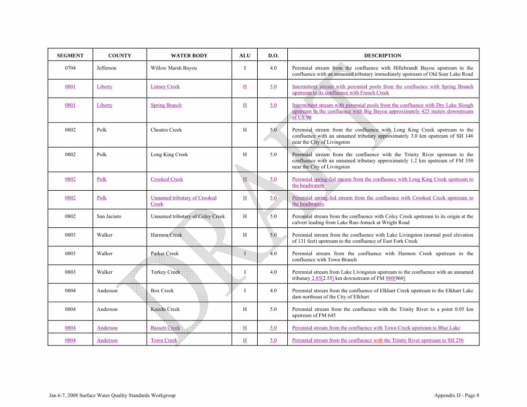
Jan 6-7, 2008 Surface Water Quality Standards Workgroup Appendix D - Page 8
SEGMENT COUNTY WATER BODY ALU D.O. DESCRIPTION
0704 Jefferson Willow Marsh Bayou I 4.0 Perennial stream from the confluence with Hillebrandt Bayou upstream to the confluence with an unnamed tributary immediately upstream of Old Sour Lake Road
0801 Liberty Linney Creek H 5.0 Intermittent stream with perennial pools from the confluence with Spring Branch upstream to its confluence with French Creek
0801 Liberty Spring Branch H 5.0 Intermittent stream with perennial pools from the confluence with Dry Lake Slough upstream to the confluence with Big Bayou approximately 425 meters downstream of US 90
0802 Polk Choates Creek H 5.0 Perennial stream from the confluence with Long King Creek upstream to the confluence with an unnamed tributary approximately 3.0 km upstream of SH 146 near the City of Livingston
0802 Polk Long King Creek H 5.0 Perennial stream from the confluence with the Trinity River upstream to the confluence with an unnamed tributary approximately 1.2 km upstream of FM 350 near the City of Livingston
0802 Polk Crooked Creek H 5.0 Perennial spring-fed stream from the confluence with Long King Creek upstream to the headwaters
0802 Polk Unnamed tributary of Crooked Creek
H 5.0 Perennial spring-fed stream from the confluence with Crooked Creek upstream to the headwaters
0802 San Jacinto Unnamed tributary of Coley Creek
H 5.0 Perennial stream from the confluence with Coley Creek upstream to its origin at the culvert leading from Lake Run-Amuck at Wright Road
0803 Walker Harmon Creek H 5.0 Perennial stream from the confluence with Lake Livingston (normal pool elevation of 131 feet) upstream to the confluence of East Fork Creek
0803 Walker Parker Creek I 4.0 Perennial stream from the confluence with Harmon Creek upstream to the confluence with Town Branch
0803 Walker Turkey Creek I 4.0 Perennial stream from Lake Livingston upstream to the confluence with an unnamed tributary 2.85[2.55] km downstream of FM 980[960]
0804 Anderson Box Creek I 4.0 Perennial stream from the confluence of Elkhart Creek upstream to the Elkhart Lake dam northeast of the City of Elkhart
0804 Anderson Keechi Creek H 5.0 Perennial stream from the confluence with the Trinity River to a point 0.05 km upstream of FM 645
0804 Anderson Bassett Creek H 5.0 Perennial stream from the confluence with Town Creek upstream to Blue Lake
0804 Anderson Town Creek H 5.0 Perennial stream from the confluence with the Trinity River upstream to SH 256

Jan 6-7, 2008 Surface Water Quality Standards Workgroup Appendix D - Page 9
SEGMENT COUNTY WATER BODY ALU D.O. DESCRIPTION
0804 Freestone Mims Creek I 4.0 Perennial stream from the confluence with Upper Keechi Creek upstream to the confluence of an unnamed tributary approximately 2.1 km upstream of FM 1580 near the City of Fairfield
0804 Henderson Walnut Creek H 5.0 Intermittent stream with perennial pools from the confluence with an unnamed tributary approximately 0.5 km upstream of FM 753 upstream to FM 2494 in the City of Athens
0804 Leon Toms Creek H 5.0 Perennial stream from the confluence with the Trinity River to the Missouri Pacific Railroad crossing near Oakwood
0804 Leon Unnamed tributary (Northwest Branch)
H 5.0 Perennial stream from the confluence with Toms Creek to a point 0.3 km upstream of FM 831
0809 Parker Walnut Creek H 5.0 Perennial stream from the confluence with Little Cypress Creek upstream to the confluence with Little Walnut Creek in Upshur County
0809 Tarrant Ash Creek H 5.0 Intermittent stream with perennial pools from Eagle Mountain Lake upstream to its confluence with Mill Branch in Parker County
0815 Ellis Waxahachie Creek I 4.0 Perennial stream from the confluence with Bardwell Reservoir (normal pool elevation of 421 feet) upstream to the confluence with North Prong Creek
0818 Henderson One Mile Creek I 4.0 Perennial stream from the confluence with Valley View Reservoir upstream to the confluence with an unnamed tributary 0.8 km upstream of SH 19
0819 Dallas Duck Creek I 4.0 Perennial stream from the confluence with the East Fork Trinity River in Kaufman County to the confluence of an unnamed tributary 0.6 km upstream of Jupiter Road in Dallas County
0819 Rockwall Buffalo Creek L 3.0 Perennial stream from the confluence with the East Fork Trinity River upstream[up] to 0.6 km above the confluence with[of] Little Buffalo Creek
0820 Collin Cottonwood Creek L 3.0 Perennial stream from the confluence with Rowlett Creek upstream[up] to SH 5 (near Greenville Road)
0820 Collin Rowlett Creek I 4.0 Perennial stream from the normal pool elevation of 435.5 feet of Lake Ray Hubbard to the Parker Road crossing
0821 Collin Pilot Grove Creek L 3.0 Perennial stream from the confluence of Desert Creek upstream[up] to FM 121 approximately five miles north of[near] the City of Blue Ridge
0823 Grayson Little Elm Creek I 4.0 Perennial stream from FM 455 in Collin County upstream[up] to 1.4 km above FM 121 in Grayson County near the City of Gunter[Gunther]
0826 Denton Denton Creek H 5.0 Perennial stream from the headwaters of Grapevine Lake upstream to the confluence of Trail Creek near the City of Justin

Jan 6-7, 2008 Surface Water Quality Standards Workgroup Appendix D - Page 10
SEGMENT COUNTY WATER BODY ALU D.O. DESCRIPTION
0826 Denton Trail Creek H 5.0 Perennial stream from the confluence with Denton Creek up to 2.1 km upstream of SH 156 in the City of Justin
0827 Dallas Cottonwood Creek I 4.0 Perennial stream from the confluence with White Rock Creek upstream to the confluence with an unnamed tributary approximately 0.25 km upstream of Campbell Road in the City of Richardson
0827 Dallas White Rock Creek I 4.0 Perennial stream from the headwaters of White Rock Lake upstream to the confluence with McKamy Branch east of the City of Addison
0836 Hill Pin Oak Creek I 4.0 Perennial stream from the confluence with the North Fork of Pin Oak Creek in Limestone County upstream to the confluence with Pin Oak Creek and an unnamed tributary flowing from the west approximately 2.8 km downstream [8.0 km upstream] of SH 171
0840 Cooke Unnamed tributary of Timber Creek
I 4.0 Intermittent stream with perennial pools from the confluence with Timber Creek upstream 1.6 km, just south of the City of Callisburg
0840 Cooke Spring Creek H 5.0 Perennial stream from the confluence with Pecan Creek upstream to the confluence with John's Branch
1000 Basin Fort Bend, Harris, Montgomery
Concrete lined and maintained channelized flood control ditches
L 3.0 Effluent dominated and noneffluent dominated perennial streams in Fort Bend, Harris, and Montgomery counties that have been channelized into trapezoidal channels by the flood control districts, whether, concrete lined or earthen and maintained by the districts
1000 Basin Fort Bend, Harris, Montgomery
Unmaintained channelized flood control ditches
I 4.0 Effluent dominated and noneffluent dominated perennial streams in Fort Bend, Harris, and Montgomery counties that have been channelized into trapezoidal channels by the flood control districts, are earthen, and are not maintained by the districts
1001 Harris Bear Lake H 4.0 Encompasses the entire tidal portion of the bay (tributary bay of San Jacinto River Tidal)
1001 Harris Gum Gully H 5.0 Perennial stream from the confluence with Jackson Bayou upstream to the confluence with an unnamed tributary approximately 0.4 km downstream of Huffman-Crosby Road
1001 Harris Jackson Bayou H 5.0 Perennial stream from a point immediately upstream of the tidal portion of Jackson Bayou upstream to the confluence with Gum Gully
1001 Harris Rickett Creek L 3.0 Intermittent stream with perennial pools from San Jacinto River Tidal upstream to US 90
1002 Liberty Tarkington Bayou I 4.0 Perennial stream from the confluence with Luce Bayou upstream to the confluence of Little Tarkington Bayou near the City of Cleveland

Jan 6-7, 2008 Surface Water Quality Standards Workgroup Appendix D - Page 11
SEGMENT COUNTY WATER BODY ALU D.O. DESCRIPTION
1004 Montgomery East Fork White Oak Creek I 4.0 Perennial stream from the confluence with White Oak Creek upstream to the confluence of an unnamed tributary approximately 0.4 km upstream of League Line Road in the City of Panorama Village
1004 Montgomery Unnamed Tributary I 4.0 Perennial stream from the confluence of the West Fork San Jacinto River upstream to the Missouri-Pacific Railroad bridge crossing located east of IH 45 and north of Needham Road approximately 10 km south of the City of Conroe
1004 Montgomery West Fork White Oak Creek H 5.0 Perennial stream from the confluence with White Oak Creek and West Fork San Jacinto River upstream to an on-channel impoundment on West Fork White Oak Creek 1.2 km upstream of League Line Road
1004 Montgomery Unnamed tributary of Woodsons Gully
H 5.0 Perennial stream from the confluence with Woodsons Gully upstream to the headwaters
1004 Montgomery Woodsons Gully H 5.0 Perennial stream from the confluence with West Fork San Jacinto River upstream to the confluence with an unnamed tributary approximately 1.9 km upstream from Riley-Fussel Road
1006 Harris Carpenters Bayou I 4.0 Perennial stream from 9.0 km upstream of the Houston Ship Channel up to 0.8 km upstream of Wallisville Road
1006 Harris Carpenters Bayou L 3.0 Perennial stream from 0.8 km upstream of Wallisville Road up to Sheldon Reservoir
1006 Harris Halls Bayou I 4.0 Perennial stream from the confluence with Greens Bayou upstream[up] to US 59
1006 Harris Halls Bayou L 3.0 Perennial stream from US 59 upstream to Frick Road
1007 Harris Berry Bayou Above Tidal L 3.0 Perennial stream from 2.4 km upstream from the confluence with Sims Bayou to the southern city limits of South Houston
1007 Harris Brays Bayou Above Tidal L 3.0 Perennial stream from 11.5 km upstream from confluence with the Houston Ship Channel upstream[up] to SH 6
1007 Harris Keegans Bayou L 3.0 Perennial stream from confluence with Brays Bayou upstream to the Harris County[Co.] line
1007 Harris Sims Bayou Above Tidal L 3.0 Perennial stream from 11.0 km upstream of the confluence with the Houston Ship Channel upstream to Hiram Clark Drive
1007 Harris Willow Waterhole Bayou L 3.0 Perennial stream from the confluence with Brays Bayou upstream to South Garden (in the City of Missouri City)
1008 Harris Metzler Creek L 3.0 Intermittent stream with perennial pools from the confluence of Cannon Gully upstream[up] to 0.2 km below Kuykendahl Road
1008 Montgomery Mill Creek I 4.0 Perennial stream from the normal pool of elevation of Neidigk Lake upstream to the confluence of Hurricane Creek and Kickapoo Creek in Grimes County

Jan 6-7, 2008 Surface Water Quality Standards Workgroup Appendix D - Page 12
SEGMENT COUNTY WATER BODY ALU D.O. DESCRIPTION
1008 Montgomery Panther Branch L 3.0 Intermittent stream with perennial pools from the normal pool elevation of 125 feet of Lake Woodlands upstream to the confluence with Bear Branch
1008 Montgomery Panther Branch I 4.0 Perennial stream from the confluence with Spring Creek upstream to the dam impounding Lake Woodlands
1008 Montgomery Arnold Branch I 4.0 Intermittent stream with perennial pools from the confluence with Mink Branch upstream to the headwaters just upstream of FM 1774
1008 Montgomery Mink Branch H 5.0 Perennial stream from the confluence with Walnut Creek upstream to the confluence with an unnamed tributary approximately 1.0 km upstream of Nichols-Sawmill Road
1008 Montgomery Sulphur Branch H 5.0 Intermittent stream with perennial pools from an unnamed reservoir, known locally as Lake Apache, upstream to FM 1774. The unnamed reservoir impounds Sulphur Branch approximately 0.8 km upstream of the confluence with Walnut Creek.
1009 Harris Dry Creek I 4.0 Perennial stream from the confluence with Cypress Creek upstream to the beginning of channelization at Jarvis Road, 0.6 km upstream from the confluence with Cypress Creek north of Hwy 290
1009 Harris Dry Creek L 3.0 Perennial stream from the point where channelization begins at Jarvis Road, which is 0.6 km upstream of the confluence with Cypress Creek, upstream to Harris County Flood Control District ditch K-145-05-00[Spring Cypress Road], 0.29[1.2] km upstream of Spring Cypress Road[Jarvis Road] north of Hwy 290
1009 Harris Dry Gully I 4.0 Perennial stream from its confluence with Cypress Creek upstream 3.2 km, which is approximately 1 km upstream of Louetta Road
1009 Harris Dry Gully L 3.0 Perennial stream from a point 1 km upstream of Louetta Road upstream to Spring Cypress Road
1009 Waller Mound Creek H 5.0 Perennial stream from the confluence with Snake Creek, which together form Cypress Creek, upstream to an unnamed tributary 1.95 km upstream of FM 362
1010 Montgomery Dry Creek I 4.0 Intermittent stream with perennial pools from Caney Creek upstream to the confluence with an unnamed tributary approximately 3.6 km upstream of SH 242
1010 Montgomery White Oak Creek H 5.0 Perennial stream from the confluence with Caney Creek upstream to the confluence with an unnamed tributary approximately 2.08 km upstream of US 59
1012 Montgomery Town Creek I 4.0 Perennial stream from the confluence with Atkins Creek upstream to the confluence with Carwile Creek
1012 Walker Robinson Creek I 4.0 Perennial stream from the confluence with the West Fork San Jacinto River upstream to the confluence with an unnamed second order tributary approximately 0.1 km upstream of Bethel Road

Jan 6-7, 2008 Surface Water Quality Standards Workgroup Appendix D - Page 13
SEGMENT COUNTY WATER BODY ALU D.O. DESCRIPTION
1013 Harris Little Whiteoak Bayou I 4.0 Perennial stream from the confluence with Whiteoak Bayou up to the railroad[RR] tracks north of IH 610
1013 Harris Little Whiteoak Bayou L 3.0 Perennial stream from the railroad[RR] tracks north of IH 610 upstream to Yale Street
1014 Harris Bear Creek I 4.0 Perennial stream from the confluence with South Mayde Creek upstream to the confluence with an unnamed tributary 1.24 km north of Longenbaugh Road
1014 Harris Buffalo Bayou I 4.0 Perennial stream from SH 6 in Harris County upstream to the confluence with Willow Fork Buffalo Bayou in Fort Bend County
1014 Harris Dinner Creek L 3.0 Perennial stream from the confluence with Langham Creek upstream to Frey Road
1014 Harris Horsepen Creek L 3.0 Perennial stream from 0.62 km north of FM 529 upstream to a point 2.4 km upstream of SH 6
1014 Harris Horsepen Creek I 4.0 Perennial stream from the confluence with Langham Creek upstream to where channelization begins, which is 0.62 km north of FM 529
1014 Harris Langham Creek L 3.0 Perennial stream from the confluence with Dinner Creek upstream to FM 529
1014 Harris Langham Creek I 4.0 Perennial stream from the confluence with Bear Creek upstream to the confluence with Dinner Creek
1014 Harris Mason Creek I 4.0 Perennial stream from the confluence with Buffalo Bayou upstream to channelization, 1.55 km south of Franz Road
1014 Harris South Mayde Creek L 3.0 Perennial stream from an unnamed tributary 1.3[0.62] km west[east] of Barker-Cypress Road upstream to an unnamed tributary 1.05 km south of Clay Road
1014 Harris South Mayde Creek I 4.0 Perennial stream in the Addicks Reservoir flood pool area, from the confluence with Buffalo Bayou upstream to the confluence with an unnamed tributary 0.62 km east of Barker-Cypress Road
1014 Harris Turkey Creek I 4.0 Perennial stream from the confluence with South Mayde Creek upstream to the headwaters south of Clay Road
1014 Waller Willow Fork Buffalo Bayou I 4.0 Intermittent stream with perennial pools from the confluence with Buffalo Bayou in Fort Bend County upstream[up] to 1.0 km above U.S. 90 in Waller County
1015 Montgomery Mound Creek H 5.0 Perennial stream from the confluence with Lake Creek upstream to the confluence with an unnamed tributary approximately 0.75 km downstream of Rabon-Chapel Road
1016 Harris Garners Bayou L 3.0 Perennial stream from the confluence with Greens Bayou Above Tidal[Williams Gully] upstream to 1.5 km north of Atoscocita Road

Jan 6-7, 2008 Surface Water Quality Standards Workgroup Appendix D - Page 14
SEGMENT COUNTY WATER BODY ALU D.O. DESCRIPTION
1017 Harris Brickhouse Gully/Bayou L 3.0 Perennial stream from the confluence with Whiteoak Bayou upstream[up] to Gessner Road
1017 Harris Cole Creek L 3.0 Perennial stream from the confluence with Whiteoak Bayou upstream[up] to Flintlock Street
1017 Harris Vogel Creek L 3.0 Perennial stream from the confluence with Whiteoak Bayou to a point 3.2 kilometers upstream of the confluence with Whiteoak Bayou
1101 Galveston Magnolia Creek I 4.0 Intermittent stream with perennial pools from the confluence with Clear Creek upstream to 0.8 km upstream of the confluence with the second unnamed tributary
1102 Brazoria Cowart Creek L 3.0 Intermittent stream with perennial pools from the confluence with Clear Creek in Galveston County upstream to SH 35 in Brazoria County
1102 Brazoria Mary’s Creek/North Fork Mary’s Creek
I 4.0 Perennial stream from the confluence with Clear Creek upstream to the confluence with North Fork Mary's Creek and South Fork Mary's Creek near FM 1128, approximately 5 km southwest of the City of Pearland. Includes perennial portions of North Fork Mary's Creek from the confluence of Mary's Creek to the confluence of an unnamed tributary approximately 3.2 km upstream of FM 1128.
1105 Brazoria Flores Bayou I 4.0 Perennial stream from a point 2.6 km downstream of County Road 171 upstream to SH 35
1111 Brazoria Flag Lake Drainage Canal I 4.0 Perennial stream from the east pumping station at the confluence with East Union Bayou to the west pumping station at the Brazos River
1202 Fort Bend Rabbs Bayou L 3.0 Perennial stream from the confluence with an unnamed tributary below HW 59 upstream[up] to Smithers Lake
1202 Fort Bend Unnamed oxbow slough L 3.0 An unnamed oxbow slough immediately north of the intersection of U.S.[US] 90A and SH 6 at the head of Ditch H
1202 Fort Bend Big Creek I 4.0 Intermittent stream with perennial pools from the confluence with an unnamed tributary 2.1 km downstream of FM 2977 upstream to the confluence of Cottonwood Creek and Coon Creek
1202 Grimes Beason Creek I 4.0 Perennial stream from the confluence with the Brazos River upstream to the confluence with an unnamed tributary 2.8 km upstream of FM 362
1202 Waller Brookshire Creek L 3.0 Perennial stream from the confluence of an unnamed tributary located 0.2 km downstream of SH 359[1.4 km downstream of IH 10] upstream to 500 meters upstream of US 90
1202 Waller Bessie's Creek I 4.0 Intermittent stream with perennial pools from the confluence with Bessie's Bayou upstream to the confluence with an unnamed tributary approximately 0.7 km upstream of FM 359 northwest of the City of Pattison

Jan 6-7, 2008 Surface Water Quality Standards Workgroup Appendix D - Page 15
SEGMENT COUNTY WATER BODY ALU D.O. DESCRIPTION
1202 Waller Clear Creek H 5.0 Perennial stream from the confluence with the Brazos River upstream to the confluence with an unnamed tributary approximately 0.2 km upstream of FM 1488
1202 Washington Hog Branch I 4.0 Perennial stream from the confluence with Little Sandy Creek upstream to Loop 318 in the City of Brenham
1202 Washington Little Sandy Creek I 4.0 Perennial stream from the confluence with New Year Creek to a point 100 meters upstream of Loop 283
1202 Washington New Year Creek I 4.0 Perennial stream from the confluence with Woodward[Ralston] Creek upstream to the confluence of Big Sandy Creek
1203 Bosque Steele Creek H 5.0 Perennial stream from the confluence with Whitney Lake upstream[up] to 2.4 km above the confluence of Cox Branch
1205 Hood McCarty Branch L 3.0 Intermittent stream with perennial pools from the confluence with Lake Granbury upstream[up] to FM 208
1206 Hood Kickapoo Creek I 4.0 Intermittent stream with perennial pools from the confluence with the Brazos River in Parker County upstream to Bailey's Lake at the Hood-Erath county line near the City of Lipan
1206 Parker Rock Creek I 4.0 Intermittent stream with perennial pools from the confluence with Dry Creek upstream to the confluence with an unnamed second order tributary approximately 0.7 km downstream of Lake Mineral Wells
1206 Parker Unnamed tributary of Rock Creek I 4.0 Intermittent stream with perennial pools from the confluence with Rock Creek upstream to the confluence with an unnamed first order tributary approximately 0.2 km upstream of Hood Road, west of Lake Mineral Wells
1209 Brazos Carters Creek I 4.0 Perennial stream from the confluence with the Navasota River upstream to the confluence of an unnamed tributary 0.5 km upstream of FM 158
1209 Brazos Wickson Creek L 3.0 Perennial stream from the confluence with an unnamed first order tributary (approximately 1.3 km upstream of Reliance Road crossing) upstream to the confluence with an unnamed first order tributary approximately 15 meters upstream of Dilly Shaw Road
1209 Brazos Wolfpen Creek L 3.0 Intermittent stream with perennial pools from the confluence with Carter Creek to near Bizzell Street in the City of College Station
1211 Burleson Davidson Creek I 4.0 Intermittent stream with perennial pools from the confluence with Yegua Creek to 0.2 km above SH 21 near the City of Caldwell
1217 Burnet North Fork Rocky Creek I 4.07 Intermittent stream with perennial pools from the confluence with South Fork Rocky Creek upstream to the confluence of an unnamed tributary approximately 5.2 km upstream of US 183

Jan 6-7, 2008 Surface Water Quality Standards Workgroup Appendix D - Page 16
SEGMENT COUNTY WATER BODY ALU D.O. DESCRIPTION
1217 Lampasas Sulphur Creek H 5.0 Perennial stream from the confluence with the Lampasas River to the spring source located in the City of Lampasas
1221 Comanche Indian Creek I 4.0 Perennial stream from the confluence with Armstrong Creek approximately 1.5 km downstream of SH 36 upstream to the confluence with an unnamed tributary approximately 0.1 km upstream of US 377[an unnamed second order tributary (approximately 0.7 km downstream of Live Oak Street crossing) upstream to the confluence with Bachelor Prong Creek]
1221 Hamilton Pecan Creek I 4.0 Perennial stream from the confluence with the Leon River upstream to the confluence with an unnamed tributary approximately 3.5 km upstream of SH 36 near the City of Hamilton
1224 Eastland Leon River Above Leon Reservoir H 5.0 From the headwaters of Leon Reservoir upstream[up] to the confluence of the North Fork Leon River and the South Fork Leon River (includes Lake Olden)
1224 Eastland South Fork Leon River H 5.0 From the confluence of the North Fork Leon River upstream[up] to the confluence of the Middle Fork Leon River
1227 Johnson Buffalo Creek L 3.0 Intermittent stream with perennial pools from the confluence with the Nolan River upstream[up] to the confluence of East Buffalo Creek and West Buffalo Creek
1227 Johnson Mustang Creek I 4.0 Intermittent stream with perennial pools from the confluence with the Nolan River upstream to FM 916 near Rio Vista
1230 Eastland Palo Pinto Creek H 5.0 Perennial stream from the confluence with Lake Palo Pinto (normal pool elevation of 867 feet) which is near the confluence with an unnamed tributary at the Texas and Pacific railroad crossing upstream to the dam forming Hagaman Lake
1232 Stephens Gonzales Creek H 5.0 Perennial stream from the confluence with Hubbard Creek upstream to the confluence with Brown Branch approximately 1.2 km upstream of Elliott Street in the City of Breckenridge
1241 Lubbock North Fork Double Mountain Fork Brazos River
L 3.0 Perennial stream from the confluence with Double Mountain Fork Brazos River to the dam forming Lake Ransom Canyon
1242 Brazos Cottonwood Branch I 4.0 Intermittent stream with perennial pools from the confluence with Still Creek upstream 0.95 km to the confluence with an unnamed tributary
1242 Brazos Still Creek H 5.0 Perennial stream from the confluence with Thompsons Creek upstream to the confluence with Cottonwood Branch
1242 Brazos Thompsons[Thompson] Creek H[I] 5.0[4.0] Perennial [Intermittent] stream [with perennial pools] from the confluence with the Brazos River upstream to the confluence with Still Creek[Thompson Branch north of FM 1687]
1242 Brazos Thompsons Creek I 4.0 Intermittent stream with perennial pools from the confluence with Still Creek upstream to the confluence with Thompsons Branch, north of FM 1687

Jan 6-7, 2008 Surface Water Quality Standards Workgroup Appendix D - Page 17
SEGMENT COUNTY WATER BODY ALU D.O. DESCRIPTION
1242 Brazos Unnamed tributary of Cottonwood Branch
I 4.0 Intermittent stream with perennial pools from the confluence with Cottonwood Branch upstream to the headwaters
1242 Falls Pond Creek L 3.0 Perennial stream from the confluence with the Brazos River in Milam County, upstream[up] to the confluence with Live Oak Creek in Falls County
1242 Falls Deer Creek H 5.0 Perennial stream from the confluence with the Brazos River upstream to the confluence with Dog Branch
1242 McLennan Tradinghouse Reservoir H 5.0 Encompasses the entire reservoir up to the normal pool elevation of 447 feet
1242 McLennan North Fork Cow Bayou I 4.0 Intermittent stream with perennial pools from the confluence with the Brazos River upstream to FM 2113
1242 Robertson Little Brazos River H 5.0 Perennial stream from the confluence with the Brazos River in Brazos County to the confluence of Walnut Creek in Robertson County west of the City of Calvert
1244 Williamson Brushy Creek H 5.0 Perennial stream from the confluence of South Brushy Creek to the confluence of North Fork Brushy Creek and South Fork Brushy Creek
1244 Williamson Mustang Creek I 4.0 Perennial stream from the confluence with Brushy Creek upstream to the confluence of North Fork Mustang Creek
1244 Williamson Cluck Creek H 5.0 Perennial stream from the confluence with South Brushy Creek upstream to the confluence with an unnamed tributary 0.6 km downstream of US 183
1244 Williamson Cottonwood Creek H 5.0 Perennial stream from the confluence with Brushy Creek upstream to the headwaters approximately 8.9 km upstream of FM 1660 north of the City of Hutto
1245 Fort Bend Red Gully I 4.0 Perennial stream from the confluence with Oyster Creek up to 1.7 km upstream of Old Richmond Road
1246 McLennan Comanche Springs Spring Brook H 5.0 Spring-fed intermittent stream with perennial pools from the confluence with Harris Creek upstream to and including Comanche Springs approximately 2.1 km upstream of US 84 west of the City of McGregor
1246 McLennan Harris Creek H 5.0 Spring-fed intermittent stream with perennial pools from the confluence with South Bosque River upstream to the confluence with an unnamed tributary approximately 1.19 km upstream of US 84 west of the City of McGregor
1246 McLennan Tonk Creek H 5.0 Intermittent stream with perennial pools from the confluence with Middle Bosque/South Bosque River upstream to the confluence with an unnamed tributary 1.0 km upstream of FM 185 near Tonkawa Falls Park
1246 McLennan Unnamed tributary of South Bosque River
I 4.0 Perennial stream from the confluence with the South Bosque River to 1.0 km above SH 317 south of the City of McGregor (locally known as Sheep Creek)

Jan 6-7, 2008 Surface Water Quality Standards Workgroup Appendix D - Page 18
SEGMENT COUNTY WATER BODY ALU D.O. DESCRIPTION
1248 Williamson Berry Creek H 5.0 Perennial stream from the confluence with the San Gabriel River upstream to the confluence of Stapp Branch southwest of the City of Florence
1304 Matagorda Linnville Bayou L 3.0 Intermittent stream with perennial pools from a point 1.1 km above the confluence with Caney Creek in Matagorda County upstream[up] to a point 0.1 km above SH 35 in Brazoria/Matagorda counties
1305 Matagorda Hardeman Slough I 4.0 Perennial stream from the confluence with Caney Creek upstream to the confluence with an unnamed tributary approximately 1.9 km downstream of FM 3156 near the City of Van Vleck
1402 Colorado Cummins Creek E 6.0 Perennial stream from the confluence with the Colorado River upstream to the confluence of Boggy Creek at FM 1291 in Colorado County
1402 Fayette Allen Creek I 4.0 Intermittent stream with perennial pools from the confluence of Pool Branch upstream to its headwaters south of the City of Fayetteville
1402 Fayette Buckners Creek H 5.0 Perennial stream from the confluence with the Colorado River upstream to the confluence with Chandler Branch 1.6 km upstream of FM 154 in Fayette County
1402 Fayette Cedar Creek Reservoir/Lake Fayette
H 5.0 Encompasses the entire reservoir up to the normal pool elevation of 390[391] feet
1402 Fayette Cedar Creek H 5.0 Perennial stream from the confluence with the Colorado River up to the dam forming Cedar Creek Reservoir/Lake Fayette
1404 Burnet Hamilton Creek I 4.0 Perennial stream from the confluence with Delaware Creek upstream to the confluence with an unnamed tributary in the City of Burnet 1.1 km upstream of the Southern Pacific Railroad
1412 Howard Beals Creek L 3.0 Intermittent stream with perennial pools from the confluence with the Colorado River in Mitchell County upstream[up] to the confluence of Mustang Draw and Sulphur Springs Draw in Howard County
1412 Mitchell North Fork Champion Creek L 3.0 Intermittent stream with perennial pools from the confluence with an unnamed tributary approximately 2.3 km upstream of IH 20 to its headwaters north of the City of Loraine
1412 Scurry Deep Creek I 4.0 Perennial stream from the confluence with Hell Roaring Hollow Creek upstream to the confluence with an unnamed first order tributary approximately 0.07 km downstream of RR 1605
1414 Gillespie Barons Creek H 5.0 Perennial stream from the confluence with the Pedernales River upstream[up] to the most northern crossing of US 87 northwest of the City of Fredericksburg
1415 Kimble Johnson Fork Creek H 5.0 Perennial stream from the confluence with the Llano River upstream to source springs (Rio Bonito Springs) south of the City of Segovia

Jan 6-7, 2008 Surface Water Quality Standards Workgroup Appendix D - Page 19
SEGMENT COUNTY WATER BODY ALU D.O. DESCRIPTION
1415 Mason Comanche Creek L 3.0 Intermittent stream with perennial pools from the confluence with the Llano River upstream[up] to the confluence of West Comanche Creek near Mason
1416 McCulloch Brady Creek I 4.0 Perennial stream and intermittent stream with perennial pools from the confluence of an unnamed tributary approximately 5.0 km east of FM 2309 east of the City of Brady upstream to Brady Lake dam
1418 Coleman Hord Creek I 4.0 Perennial stream from the confluence with an unnamed second order tributary (approximately 0.7 km downstream of Live Oak Street crossing) upstream to the confluence with Bachelor Prong Creek
1420 Callahan Kaiser Creek L 3.0 Intermittent stream with perennial pools from the confluence with North Prong Pecan Bayou upstream[up] to 0.5 km upstream of FM 2700 south of the City of Clyde
1420 Callahan Turkey Creek H 5.0 From the confluence with Pecan Bayou in Brown County upstream[up] to SH 36 in Callahan County
1426 Runnels Elm Creek H 5.0 Perennial stream from the confluence with the Colorado River upstream[up]to the dam approximately 300 meters downstream of U.S. Highway 67
1427 Travis Slaughter Creek H 5.0 Intermittent stream with perennial pools from the confluence with Onion Creek upstream to Brodie Lane in southwest Austin [above US 290 west of Austin]
1427 Travis Slaughter Creek I 4.0 Intermittent stream with perennial pools from Brodie Lane upstream to above U.S. 290 west of the City of Austin
1428 Travis Gilleland Creek H 5.0 Perennial stream [and intermittent stream with perennial pools] from the confluence with the Colorado River upstream to an unnamed tributary 0.39 km upstream of Ward Spring Road [to the spring source (Ward Spring) northwest of Pflugerville]
1428 Travis Gilleland Creek H 5.0 Intermittent stream with perennial pools from the confluence with an unnamed tributary 0.39 km upstream of Ward Spring Road upstream to the spring source (Ward Spring) northwest of Pflugerville
1428 Travis Dry Creek - downstream perennial H 5.0 Perennial stream from the mouth of the Colorado River upstream to 150 meters upstream of the confluence with Cottonwood Creek
1428 Travis Dry Creek - downstream with intermittent with perennial pools
L 3.0 Intermittent stream with perennial pools from 150 meters upstream of the confluence with Cottonwood Creek upstream to just below the confluence with an unnamed tributary located approximately 2.73 km upstream of Wolf Lane. Channel topography in this reach is a braided to anastomosiging channel, and all channels within the reach are intermittent with perennial pools.
1428 Travis Dry Creek - upstream perennial E 6.0 Perennial stream from the confluence with an unnamed tributary, located approximately 2.73 km upstream of Wolf Lane, upstream to the confluence of North Fork Dry Creek and Dry Creek

Jan 6-7, 2008 Surface Water Quality Standards Workgroup Appendix D - Page 20
SEGMENT COUNTY WATER BODY ALU D.O. DESCRIPTION
1428 Travis Dry Creek - upstream with pools L 3.0 Intermittent stream with perennial pools from the confluence with North Fork Dry Creek upstream to U.S.183 south of Pilot Knob
1428 Travis Harris Branch H 5.0 Perennial stream from the confluence with Gilleland Creek upstream to the confluence with an unnamed tributary approximately 2.6 km downstream of Gregg Lane
1428 Travis Unnamed tributary of Harris Branch
L 3.0 Intermittent stream with perennial pools from the confluence with Harris Branch upstream to the confluence with an unnamed tributary approximately 0.7 km downstream of the Old railroad grade
1434 Bastrop Cedar Creek H 5.0 Perennial stream from the confluence with the Colorado River upstream to the confluence of an unnamed tributary at FM 535 in Bastrop County
1434 Bastrop Gazley Creek I 4.0 Perennial stream from the confluence with the Colorado River above La Grange upstream to the confluence with an unnamed tributary approximately 3.25 km upstream of the southern-most crossing of the Missouri-Kansas-Texas Railroad south of the City of Smithville
1434 Bastrop Maha Creek I 4.0 Intermittent stream with perennial pools from the confluence with Cedar Creek upstream to the confluence with an unnamed tributary approximately 0.25 km upstream of U.S. 183 in Travis County
1501 Matagorda Wilson Creek H 5.0 Perennial stream from the confluence with the Tres Palacios River upstream to the confluence with the first tributary south of IH 35
1602 DeWitt Big Brushy Creek H 5.0 Perennial stream from the confluence with Clarks Creek in Lavaca County upstream to the confluence with an unnamed tributary just downstream of the Loop 51 (U.S. Highway B77) bridge crossing south of the City of Yoakum
1602 Lavaca Rocky Creek H 5.0 Perennial stream from the confluence with the Lavaca River upstream[up] to 1.0 km above FM 533 west of the City of Shiner
1602 Lavaca Lavaca River H 5.09 Intermittent stream with perennial pools from the confluence of Campbells Creek west of the City of Hallettsville upstream to the confluence with West Prong Lavaca River downstream of the City of Moulton
1604 Wharton East Mustang Creek I 4.0 Intermittent stream with perennial pools from the confluence with Middle Mustang Creek upstream to the confluence with an unnamed tributary approximately 4.2 km upstream of U.S.[US] 59 northeast of the City of Louise
1605 Fayette West Navidad River H 5.0 Intermittent stream with perennial pools from the confluence with the Navidad River above Lake Texana in Lavaca County upstream to the confluence with Walker Branch approximately 0.5 km upstream of IH 10
1806 Kerr Camp Meeting Creek H 4.010 Perennial stream from the confluence with the Guadalupe River upstream to an unnamed impoundment, located downstream of Ranchero Road in the City of Kerrville

Jan 6-7, 2008 Surface Water Quality Standards Workgroup Appendix D - Page 21
SEGMENT COUNTY WATER BODY ALU D.O. DESCRIPTION
1806 Kerr Camp Meeting Creek H 3.010 Perennial stream from an unnamed impoundment, located downstream of Ranchero Road, upstream to the dam of an unnamed impoundment approximately 0.65 km upstream of Tree Lane in the City of Kerrville
1810 Caldwell Town Branch H 5.0 Perennial stream from the confluence with Plum Creek upstream to U.S.[US] 183 in the City of Lockhart
1902 Bexar Martinez Creek I 4.0 Perennial stream from the confluence with Escondido Creek upstream to Binz-Engleman Road
1903 Medina Polecat Creek H 5.0 Perennial stream from 6.4 km above the confluence with the Medina River upstream to the spring source 1.3 km above FM 2790 southeast of the City of LaCoste
1910 Bexar Salado Creek L 4.0 Intermittent stream with perennial pools from the confluence with Beitel Creek upstream to Nacogdoches Road
2107 Atascosa West Prong Atascosa River I 4.0 Intermittent stream with perennial pools from the confluence with the Atascosa River upstream to the confluence with an unnamed tributary at IH 35
2108 Medina Chacon Creek I 4.0 Perennial stream from the confluence with San Francisco Perez Creek in Frio County upstream to the confluence of an unnamed tributary approximately 0.8 km north of SH 132 in Medina County
2108 Medina Fort Ewell Creek I 4.0 Perennial stream from the confluence with Chacon Creek in Medina County upstream to the confluence of the Natalia Canal approximately 0.8 km north of SH 132 in Medina County
2201 Cameron, Hidalgo, Willacy
Drainage Ditches L 3.0 Perennial drainage ditches that flow into the segment in the counties listed
2202 Cameron, Hidalgo Drainage Ditches L 3.0 Perennial drainage ditches that flow into the segment in the counties listed
2304 Val Verde Cienegas Creek H 5.0 Perennial stream from the confluence with the Rio Grande River upstream to the headwater spring source (Cienegas Springs) approximately 0.8 km north of Cienega Lane west of the City of Del Rio
2310 Terrell Independence Creek E 6.0 Perennial stream from the confluence of the Pecos River to the mouth of Surveyor Canyon (upstream of FM 2400)
2422 Chambers Anahuac Ditch I 4.0 Perennial stream from the confluence with [the] West Fork Double Bayou upstream to FM 563 near the City of Anahuac
2425 Harris Taylor Lake H 4.0 Encompasses the entire tidal portion of the bay (tributary bay of Clear Lake) including Taylor Bayou Tidal
2426 Harris Goose Creek I 4.0 Perennial stream from Baker Street upstream[up] to the confluence of an unnamed tributary from Highlands Reservoir

Jan 6-7, 2008 Surface Water Quality Standards Workgroup Appendix D - Page 22
SEGMENT COUNTY WATER BODY ALU D.O. DESCRIPTION
2426 Harris Goose Creek L 3.0 Perennial stream from the confluence of East Fork Goose Creek upstream[up] to Baker Street
2432 Brazoria Mustang Bayou I 4.0 Perennial stream from County Road 166 upstream to the confluence with an unnamed tributary 0.3 kilometers upstream of SH 35
2491 Cameron, Hidalgo Drainage Ditches L 3.0 Perennial drainage ditches that flow into the segment in the counties listed
2494 Cameron Drainage Ditches L 3.0 Perennial drainage ditches that flow into the segment in the counties listed 1 The following site-specific multiple regression equation shall be used to determine the 24-hour average dissolved oxygen criterion if ambient values fall below 5.0 mg/L from May to October. The
corresponding minimum dissolved oxygen criterion shall be 1.0 mg/L less than the calculated 24-hour average criterion. A minimal flow value of 0.01 cfs shall be used in the equation for instances of observed zero flow.
DO = 12.3 - 0.309 T + 1.05 logQ - 1.02 logWS where DO = 24-hour average dissolved oxygen criterion T = temperature in degrees Celsius Q = flow in cfs WS = watershed size in square kilometers
2[1] A site-specific low-flow of 5.95 cfs applies to achieve the 4.0 mg/L dissolved oxygen 24-hour average criterion at the critical summer-time temperatures of 29.7°C. A site-specific[site specific] dissolved oxygen criterion of 3.0 mg/L as a 24-hour average applies from May to October when flows are ≥1.2 cfs and < 5.95 cfs. The following site-specific multiple regression equation relating dissolved oxygen averages, flow, and temperature may be used to determine appropriate headwater flows:
Q = e (0.253T-10.4 + DO)/0.625
where Q = flow in cfs T = temperature in degrees Celsius DO = 24-hour average dissolved oxygen criteria
3[2] A site-specific dissolved oxygen criterion of 3.0 mg/L as a 24-hour average applies for the months of June through October. 4[3] A site-specific dissolved oxygen criterion of 3.0 mg/L as a 24-hour average applies to the unnamed tributary due to low ambient levels of dissolved oxygen upstream of the City of Grand Saline
discharge. 5[4] A site-specific dissolved oxygen criterion of 4.0 mg/L as a 24-hour average applies for the months of May through October. 6[5] A site-specific dissolved oxygen criterion of 3.0 mg/L as a 24-hour average applies for the months of May through October. 7 A site-specific 24-hour average dissolved oxygen criterion of 2.0 mg/L and a minimum dissolved oxygen criterion of 1.0 mg/L applies for the months of May through October. 8[6] A site-specific dissolved oxygen criterion of 3.0 mg/L as a 24-hour average applies to the designated perennial canals. 9 A site-specific dissolved oxygen criterion of 3.0 mg/L as a 24-hour average applies for the months of May through October. No minimum dissolved oxygen criterion shall apply for the months of
May through October. 10 A minimum dissolved oxygen criterion of 2.0 mg/L applies to the described portion of the water body.