Figure 24: Functional Classification Map Weld County ... County Functional Classification Map ......
1
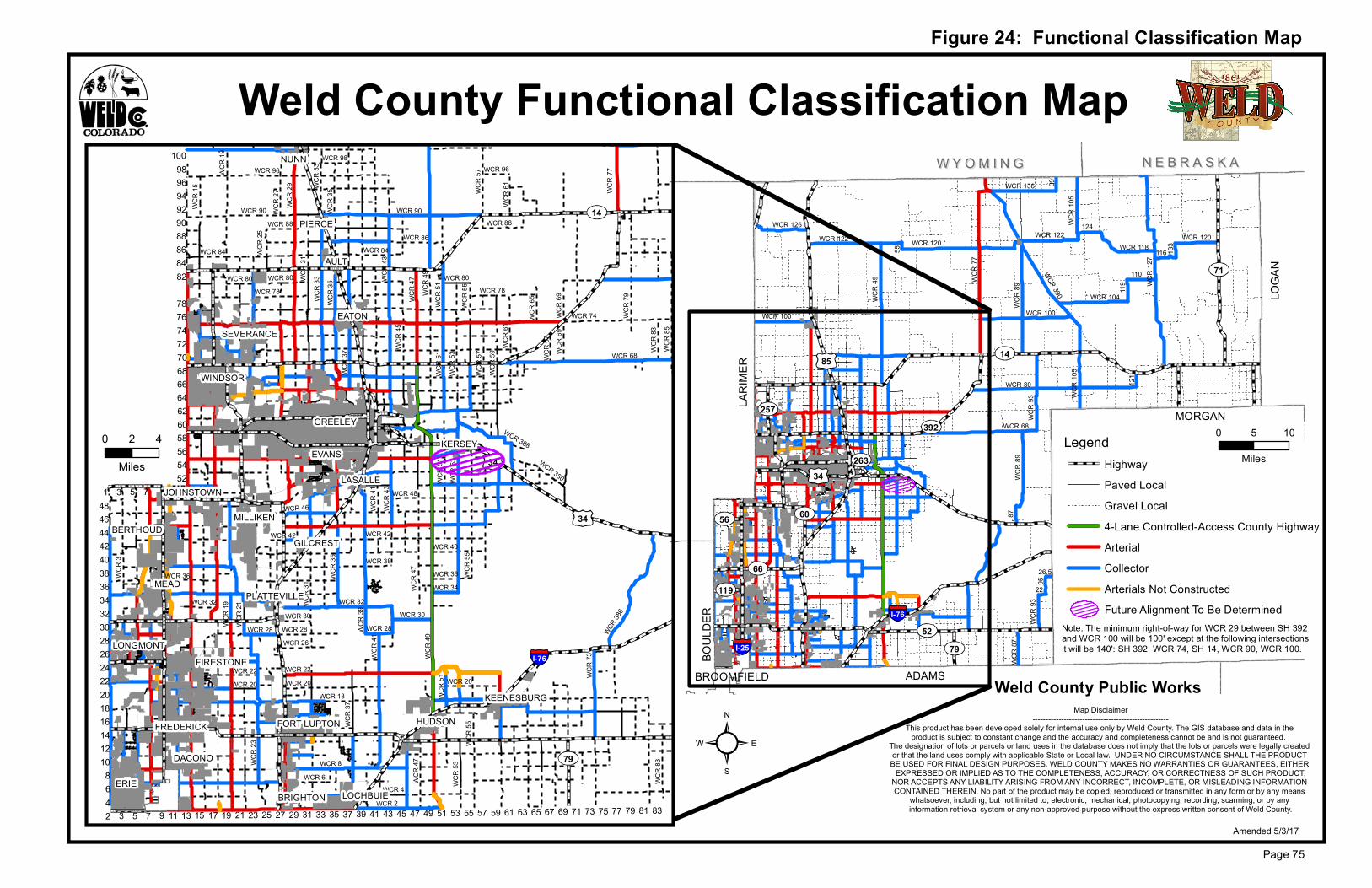
WYOMING WYOMING NEBRASKA NEBRASKA LOGAN MORGAN LARIMER ADAMS BROOMFIELD BOULDER WCR 77 WCR 120 WCR 390 WCR 104 WCR 126 WCR 80 WCR 100 WCR 118 WCR 89 WCR 87 WCR 127 WCR 105 WCR 122 WCR 122 WCR 136 99 WCR 89 WCR 93 WCR 68 WCR 120 110 119 WCR 105 WCR 49 WCR 100 WCR 93 95 22 26.5 87 121 133 116 124 55 I-76 I-25 34 85 66 56 52 257 392 263 60 119 79 71 14 2 1 3 5 7 9 4 6 8 3 5 7 13 74 98 11 15 17 19 21 23 25 27 29 31 33 35 37 39 41 43 45 47 49 51 53 55 57 59 61 63 65 67 69 71 73 75 77 79 81 83 10 12 14 16 18 20 22 24 26 28 30 32 34 36 38 40 42 44 46 48 52 54 56 58 60 62 64 66 68 70 72 76 78 82 84 86 88 90 92 94 96 100 14 79 34 34 WCR 74 WCR 43 WCR 29 WCR 49 WCR 86 WCR 68 WCR 42 WCR 73 WCR 22 WCR 39 WCR 47 WCR 90 WCR 19 WCR 96 WCR 79 WCR 21 WCR 15 WCR 85 WCR 48 WCR 80 WCR 32 WCR 51 WCR 386 WCR 37 WCR 59 WCR 20 WCR 6 WCR 33 WCR 18 WCR 55 WCR 4 WCR 57 WCR 45 WCR 2 WCR 46 WCR 98 WCR 34 WCR 35 WCR 53 WCR 388 WCR 28 WCR 78 WCR 38 WCR 88 WCR 40 WCR 380 WCR 3 WCR 26 WCR 31 WCR 69 WCR 61 WCR 41 WCR 30 WCR 83 WCR 36 WCR 65 WCR 25 WCR 8 WCR 67 WCR 84 WCR 23 WCR 27 WCR 43 WCR 49 WCR 47 WCR 37 WCR 96 WCR 90 WCR 35 WCR 83 WCR 28 WCR 55 WCR 19 WCR 61 WCR 84 WCR 30 WCR 88 WCR 28 WCR 53 WCR 33 WCR 36 WCR 51 WCR 31 WCR 35 WCR 47 WCR 32 WCR 78 WCR 69 WCR 53 WCR 80 WCR 57 WCR 20 WCR 20 WCR 41 WCR 80 WCR 51 WCR 22 WCR 55 WCR 51 WCR 42 I-76 Weld County Functional Classification Map Figure 24: Functional Classification Map Map Disclaimer ---------------------------------------------------- This product has been developed solely for internal use only by Weld County. The GIS database and data in the product is subject to constant change and the accuracy and completeness cannot be and is not guaranteed. The designation of lots or parcels or land uses in the database does not imply that the lots or parcels were legally created or that the land uses comply with applicable State or Local law. UNDER NO CIRCUMSTANCE SHALL THE PRODUCT BE USED FOR FINAL DESIGN PURPOSES. WELD COUNTY MAKES NO WARRANTIES OR GUARANTEES, EITHER EXPRESSED OR IMPLIED AS TO THE COMPLETENESS, ACCURACY, OR CORRECTNESS OF SUCH PRODUCT, NOR ACCEPTS ANY LIABILITY ARISING FROM ANY INCORRECT, INCOMPLETE, OR MISLEADING INFORMATION CONTAINED THEREIN. No part of the product may be copied, reproduced or transmitted in any form or by any means whatsoever, including, but not limited to, electronic, mechanical, photocopying, recording, scanning, or by any information retrieval system or any non-approved purpose without the express written consent of Weld County. Page 75 Amended 5/3/17 WINDSOR SEVERANCE EVANS LASALLE GILCREST MILLIKEN JOHNSTOWN BERTHOUD MEAD PLATTEVILLE FIRESTONE KEENESBURG EATON AULT PIERCE NUNN FREDERICK DACONO GREELEY FORT LUPTON BRIGHTON LOCHBUIE ERIE HUDSON LONGMONT Weld County Public Works WCR 77 0 4 2 Miles KERSEY Note: The minimum right-of-way for WCR 29 between SH 392 and WCR 100 will be 100' except at the following intersections it will be 140': SH 392, WCR 74, SH 14, WCR 90, WCR 100. Legend Highway Paved Local Gravel Local 4-Lane Controlled-Access County Highway Arterial Collector Arterials Not Constructed Future Alignment To Be Determined 0 10 5 Miles
Transcript of Figure 24: Functional Classification Map Weld County ... County Functional Classification Map ......
W Y O M I N GW Y O M I N G N E B R A S K AN E B R A S K A
LOGA
N
MORGAN
LARI
MER
ADAMSBROOMFIELD
BOUL
DER
WCR
77
WCR 120
WCR 390 WCR 104
WCR 126
WCR 80
WCR 100
WCR 118
WCR
89WC
R 87
WCR
127
WCR
105
WCR 122 WCR 122
WCR 136 99
WCR
89WC
R 93
WCR 68
WCR 120
110
119
WCR
105
WCR
49
WCR 100
WCR
9395
22
26.5
87
121
133
116
124
55
I-76
I-25
34
85
66
56
52
257392
263
60
119
79
71
14
2
1
3 5 7 9468
3 5 7
13
74
98
11 15 17 19 21 23 25 27 29 31 33 35 37 39 41 43 45 47 49 51 53 55 57 59 61 63 65 67 69 71 73 75 77 79 81 83
1012141618202224262830323436384042444648
5254565860626466687072
7678
8284868890929496
100
14
79
34
34
WCR 74
WCR
43
WCR
29
WCR
49
WCR 86
WCR 68
WCR 42
WCR
73
WCR 22
WCR
39
WCR
47
WCR 90WC
R 19
WCR 96
WCR
79
WCR
21
WCR
15
WCR
85
WCR 48
WCR 80
WCR 32
WCR
51
WCR 38
6
WCR
37
WCR
59
WCR 20
WCR 6
WCR
33
WCR 18
WCR
55
WCR 4
WCR
57
WCR
45
WCR 2
WCR 46
WCR 98
WCR 34
WCR
35
WCR
53
WCR 388
WCR 28
WCR 78
WCR 38
WCR 88
WCR 40
WCR 380
WCR
3
WCR 26
WCR
31
WCR
69
WCR
61
WCR
41
WCR 30
WCR
83
WCR 36
WCR
65
WCR
25
WCR 8
WCR
67
WCR 84WC
R 23
WCR
27
WCR
43
WCR
49WC
R 47
WCR
37
WCR 96
WCR 90WCR
35
WCR
83
WCR 28
WCR
55
WCR
19
WCR
61
WCR 84
WCR 30
WCR 88
WCR 28
WCR
53
WCR
33
WCR 36
WCR
51
WCR
31
WCR
35
WCR
47
WCR 32
WCR 78
WCR
69
WCR
53
WCR 80
WCR
57
WCR 20WCR 20
WCR
41
WCR 80
WCR
51
WCR 22
WCR
55
WCR
51
WCR 42
I-76
Weld County Functional Classification Map
Figure 24: Functional Classification Map
Map Disclaimer----------------------------------------------------
This product has been developed solely for internal use only by Weld County. The GIS database and data in the product is subject to constant change and the accuracy and completeness cannot be and is not guaranteed.
The designation of lots or parcels or land uses in the database does not imply that the lots or parcels were legally created or that the land uses comply with applicable State or Local law. UNDER NO CIRCUMSTANCE SHALL THE PRODUCT BE USED FOR FINAL DESIGN PURPOSES. WELD COUNTY MAKES NO WARRANTIES OR GUARANTEES, EITHER
EXPRESSED OR IMPLIED AS TO THE COMPLETENESS, ACCURACY, OR CORRECTNESS OF SUCH PRODUCT,NOR ACCEPTS ANY LIABILITY ARISING FROM ANY INCORRECT, INCOMPLETE, OR MISLEADING INFORMATION CONTAINED THEREIN. No part of the product may be copied, reproduced or transmitted in any form or by any means
whatsoever, including, but not limited to, electronic, mechanical, photocopying, recording, scanning, or by any information retrieval system or any non-approved purpose without the express written consent of Weld County.
Page 75Amended 5/3/17
WINDSOR
SEVERANCE
EVANS
LASALLE
GILCREST
MILLIKEN
JOHNSTOWN
BERTHOUD
MEADPLATTEVILLE
FIRESTONE
KEENESBURG
EATON
AULT
PIERCE
NUNN
FREDERICK
DACONO
GREELEY
FORT LUPTON
BRIGHTON LOCHBUIEERIE
HUDSON
LONGMONT
Weld County Public Works
WCR
77
0 42
MilesKERSEY
Note: The minimum right-of-way for WCR 29 between SH 392and WCR 100 will be 100' except at the following intersections it will be 140': SH 392, WCR 74, SH 14, WCR 90, WCR 100.
LegendHighwayPaved LocalGravel Local4-Lane Controlled-Access County HighwayArterialCollectorArterials Not ConstructedFuture Alignment To Be Determined
0 105
Miles