Field Study of the Archaeological Sites · The southern Iraqi Marshes or Marshlands are situated in...
30
Archaeological survey of the Marshlands of southern Iraq Abdulamir Hamdani December 2011
Transcript of Field Study of the Archaeological Sites · The southern Iraqi Marshes or Marshlands are situated in...
Archaeological survey of the Marshlands of southern Iraq
Abdulamir Hamdani
December 2011

1 | P a g e
This report was prepared by Abdulamir Hamdani, PhD candidate in Mesopotamian Archaeology, Department of Anthropology, State University of New York at Stony Brook, following his intensive survey of the Marshlands conducted as part of the joint UNEP-UNESCO Project World Heritage Inscription Process as a Tool to Enhance Natural and Cultural Management of the Iraqi Marshlands.
The author started surveying the region between 2003 and 2010 when he was Inspector at Dhi Qar Antiquities Office (Iraqi State Board of Antiquities and Heritage). He also undertook two intensive surveys: in 2009 in coordination with the NGO Nature Iraq to identify sites inside and on the boundaries of the Central Marshes National Park; and in June-July 2010 with funding from the UNESCO Iraq Office in the framework of the joint UNEP-UNESCO project on the Marshlands.
If not otherwise mentionned, photos and maps are by the author and cannot be reprinted without his permission.
Author’s email: [email protected] & [email protected]

2 | P a g e
Table of Contents
1. Geography………………………………………………………………………………………………………………….……………. 3
2. Review of literature…………………………………………………………………………………………………………….……. 5
3. Survey ……………………………………………………………………………………………………………………………….……… 8
4. Bibliographical references ……………………………………………………………………………………………………... 12
5. Appendixes…………………………………………………………………………………………………………………….………. 13
5.1 GPS coordinates of archaeological sites …………………………………………………………….……….………… 14
5.2 Photos of selected sites from the surveyed areas................................................................... 16
List of maps
1. General map of the Marshlands with limits of main regions………………………………………...……..…… 3
2. Extent of permanent and temporary marshes ………………………………………………..…………….…………. 4
3. Recently Discovered Ancient Sites in the Hammar Lake District (1960) …………………................... 7
4. Surveyed Area 1………………………………………………………………………………………………………………....……. 8
5 Surveyed Area 2 ……………………………………………………………………………………………………………………….. 9
6. Surveyed Area 3 ………………………………………………………………………….…………………………………………… 9
7. Surveyed Area 4……………………………………………………………………………………………………………………… 10
8. Surveyed Area 5……………………………………………………………………………………………………………………… 10
9. General map of archaeological sites in the southern Marshes……………….………………..……………… 13

3 | P a g e
1. Geography
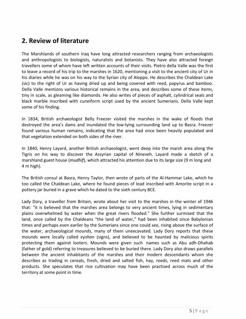
The southern Iraqi Marshes or Marshlands are situated in the southern part of Mesopotamia (today’s Iraq) mainly between 35, 30, 45 and 32 degrees longitude and 13 and 48 degrees latitude in a region that forms a triangle. This triangle’s apex lies in the Amara territory and its base is located between Basra and Suq ash-Shuyukh in the Nasiriyah Governorate. The marshes cover some 35,000 sq. km, most of them seasonal, and some 9,000 sq. km perennial. They contain natural islands where houses have been constructed. Vegetation includes reeds and papyrus used by human communities. This vegetation forms a thick forest only accessible through narrow passageways.
The Marshlands comprise three main regions:
1) Al-Huwayzah Marshes lying on the eastern coast of the Tigris and extending to the border with Iran. Water comes from three tributaries: Al-Mesharah and Al-Kahla in Emara, and Al- Karkhe in Iran. These tributaries flow into the Tigris mostly through the Al-Sewaib river.
2) The Central Marshes lying in the low delta area between the Tigris and the Euphrates. The most important parts are the Al-Zechry and the Abu Qalam Hors. Water comes from the Mejar al-Kabeer, the Mejar al-Sagheer and the Al-Betera rivers which flow into the Euphrates.
3) Al-Hammar Marshes to the west of the Euphrates which are the main focus of the present report.
Map 1: General map of the Marshlands with limits of main regions

4 | P a g e
The Al-Hammar Marshes are an oval-shaped reservoir situated between the edge of the desert to the west and the present course of the Euphrates to the east. Their southern base extends from the Garmat Ali and Rumeyla oil fields to the date-palm groves in Suq ash-Shuyukh. The area is some 90 km long and 30 km wide. In times of floods, the marshes reach a size of 3,000 sq. km, whereas in times of droughts, they retreat to 600 sq. km. The marshes form a lake with water supply coming from the Euphrates in the southern tip of Nasiriyah Governorate and from other tributaries belonging to the Euphrates river system. Surplus water from the Tigris is fed into the lake during the floods, returning to the river through irrigation locks at the Chebaish- Gurna highway. This water then flows from the Al-Hammar Marshes into the Arab Gulf.
Map 2: Extent of permanent and temporary marshes
5 | P a g e
2. Review of literature
The Marshlands of southern Iraq have long attracted researchers ranging from archaeologists and anthropologists to biologists, naturalists and botanists. They have also attracted foreign travellers some of whom have left written accounts of their visits. Pietro della Valle was the first to leave a record of his trip to the marshes in 1620, mentioning a visit to the ancient city of Ur in his diaries while he was on his way to the Syrian city of Aleppo. He describes the Chaldean Lake (sic) to the right of Ur as having dried up and being covered with reed, papyrus and bamboo. Della Valle mentions various historical remains in the area, and describes some of these items, tiny in scale, as gleaming like diamonds. He also writes of pieces of asphalt, cylindrical seals and black marble inscribed with cuneiform script used by the ancient Sumerians. Della Valle kept some of his finding.
In 1834, British archaeologist Belly Freezer visited the marshes in the wake of floods that destroyed the area’s dams and inundated the low-lying surrounding land up to Basra. Freezer found various human remains, indicating that the area had once been heavily populated and that vegetation extended on both sides of the river.
In 1840, Henry Layard, another British archaeologist, went deep into the marsh area along the Tigris on his way to discover the Assyrian capital of Nineveh. Layard made a sketch of a marshland guest house (mudhīf), which attracted his attention due to its large size (9 m long and 4 m high).
The British consul at Basra, Henry Taylor, then wrote of parts of the Al-Hammar Lake, which he too called the Chaldean Lake, where he found pieces of lead inscribed with Amorite script in a pottery jar buried in a grave which he dated to the sixth century BCE.
Lady Dory, a traveller from Britain, wrote about her visit to the marshes in the winter of 1946 that: "it is believed that the marshes area belongs to very ancient times, lying in sedimentary plains overwhelmed by water when the great rivers flooded." She further surmised that the land, once called by the Chaldeans “the land of water,” had been inhabited since Babylonian times and perhaps even earlier by the Sumerians since one could see, rising above the surface of the water, archaeological mounds, many of them unexcavated. Lady Dory reports that these mounds were locally called eyshan (signs), and believed to be haunted by malicious spirits protecting them against looters. Mounds were given such names such as Abu adh-Dhahab (father of gold) referring to treasures believed to be buried there. Lady Dory also draws parallels between the ancient inhabitants of the marshes and their modern descendants whom she describes as trading in cereals, fresh, dried and salted fish, hay, reeds, reed mats and other products. She speculates that rice cultivation may have been practised across much of the territory at some point in time.
6 | P a g e
During his inspection of the railway connecting Khamisayah to Basra, British inspector John Philippi wrote that he had sailed on the Al-Hammar Lake south of Suq ash-Shuyukh in a boat similar to Noah’s Ark. His journey was interrupted by a sudden storm, and he stayed the night on an eyshan in the middle of the lake.
The area was also later visited by British explorer Wilfred Thesiger, a retired soldier, who spent several years in the marshes between 1951 and 1957. In his memoirs, The Marsh Arabs, Thesiger writes that he was once offered an ancient seal and a piece of lead engraved with symbolic characters, and reports seeing a bare hill some 30 ft high above the reeds. The hill was regarded by the local people as an eyshan and the site of an ancient city. Thesiger mentions a smaller mound, named Aziza, covered with undecorated shards of pottery and sky-blue glass. People would find square, flat stones inscribed with cuneiform characters or architectural pieces, such as dark green bricks. Most likely, these remains belong to the Islamic period, though those from lower levels might belong to earlier periods as well.
Gavin Maxwell, a Scottish naturalist, accompanied Thesiger in 1956 and spent several weeks in the marshes. He recounted his experience in A Reed Shaken by the Wind.
Gavin Young, a British journalist, visited the region and befriended Thesiger with whom he photographed the area during the 1950s. In his book, Return to the Marshes, Young writes:
"An overhead view will make you see the Sumerian lands as a scene spotted with thousands of hills, mounds and islands which all indicate the sites of cottages, villages and cities as mysterious remnants. Most of them are neither excavated nor named. They are waiting for specialists to come. Many of these sites are hidden in the marshes. Some of them are as solid as the land, say, if not as stone. One of them is called Abu Shether. It lies in the middle marshes and is of 300m in length and 200m width and 10m height above the level of water. It had been the subject of many terrifying folktales. It is said that it is guarded by ghosts in the capacity of caretakers of a buried treasure, which disappeared all of a sudden from the sight by the effect of a magical spell.”
The first scientific attempt to survey the archeological sites was made by French engineer and archeologist George Roux during the years 1953 to 1957. Roux worked for the Basra Oil Company and in his spare time started a campaign to survey all the lands surrounding the Shiaba and Rumelya oil fields in Basra. He explored by boat the Al-Hammar Lake north of Basra until Suq ash-Shuyukh. The expedition was accompanied by a helicopter flying over the area in an attempt to detect ancient mounds. Roux visited some of these mounds but could not complete his survey due to lack of time and restrictions from the Iraqi authorities. Later on, however, Roux was able to visit six additional mounds. Of these, Tell Toba is situated at the demarcation line between the desert and the muddy region adjacent to the western part of the marsh about 10 miles north of Shiaba. The other five mounds are located inside the water triangle that forms the Al-Hammar Lake.

7 | P a g e
Roux drew a map of the area on which he marked all the sites that he had been able to explore. He made great efforts to identify the peoples who had once inhabited the area but failed to discover evidence to support his hypotheses, in large part because of more recent layers of human and animal waste covering the area. Roux interpreted these layers as evidence that the area was once populated by water buffalos and fishermen. He assigned the sites to two categories, Islamic and pre-Islamic, the latter including Tell Omar, Nakhelah, Tell Abu Salabikh, Abu Shueyab and Tell Akra. He also visited the Leqit and Shawosh castles, dating to the Islamic period, but he was not able to visit Tell Jadida despite various attempts1.
Map 3: From Georges Roux (1960): Recently Discovered Ancient Sites in the Hammar Lake District (Southern Iraq).
1
The author of this report also failed to visit the latter site as his jeep got stuck in the mud.

8 | P a g e
3. Survey
Based on field survey conducted by the author in June-July 2010, archaeological sites in the Marshlands can be divided into five areas:
Area 1 is composed of some 25 sites located east of the ancient cities of Ur and Tell Laham, north of the border with the desert, and south of Suq ash-Shuyukh in the Al-Hammar Marshes. These sites lie on both sides of the former river bed of the Euphrates and date to the third dynasty of Ur (ca. 2113-2006 BCE) and the Old Babylonian period (ca.2000-1595 BCE). Evidences have also been found at the sites of occupation during the late Mesopotamian periods, Parthian period (125 BCE-240 CE) and Sassanid period (ca. 240-637 CE).
Map 4: Surveyed Area 1

9 | P a g e
Area 2 lies just south of the current Euphrates river between Suq ash-Shuyukh and Chibayesh in the Al-Hammar Marshes. These sites belong to the Parthian through to the Sassanid and Islamic periods. Most of them were impacted by floods and the activities of fishermen during the 1960s and 1970s.
Map 5: Surveyed Area 2
Area 3 includes 15 sites located on the northwestern edge of the Central Marshes north of the Euphrates and between Islah in the west and Qorna in the east. They mostly belong to the late Abbasid period (ca. 750-1258 CE).
Map 6: Surveyed Area 3

10 | P a g e
Area 4 dates to the Parthian period, the Kingdom of Missan (100 BCE-175 CE), the early and late Abbasid period (ca. 750-1258 CE), and the early Ottoman period. The 13 sites are located on both sides of the Tigris in the Central Marshes between Uzair in the south and Qalat Salih in the north towards Mejar al-Kabeer.
Map 7: Surveyed Area 4
Area 5 comprises of Islamic sites located on both sides of the Tigris and the Shatt al-Arab, between Uzair and Qorna in the north and Basra in the south. These settlements were probably under the control of the city of Basra.
Map 8: Surveyed Area 5

11 | P a g e
The Huwaizah Marshes are yet to be surveyed. They cover a very large area located east of the Tigris River south of Amara city all the way to the Iranian border. I expect the Huwaizah Marshes to include numerous sites dating to the Hellenistic period, the Kingdom of Missan, and the Sassanid and Islamic periods.

12[ Page
4. Bibliographical references Della Valle, Pietro (1658) Viaggi di Pietro Della Valle, Il Pellegrino: La Persia, PT. 2. L'India ed Il Ritorno in Patria.
Layard, Austen Henry (2001) Discoveries in the Ruins of Nineveh and Babylon, with Travels in Armenia, Kurdistan and the Desert, Part 1 , (First published 1853), London: John Murray.
Maxwell, Gavin (1959) A Reed Shaken by the Wind: A Journey through the Unexplored Marshlands of Iraq, London: Longmans. Roux, Georges (1960) “Recently Discovered Ancient Sites in the Hammar Lake District (Southern Iraq)”, Sumer Magazine, Vol. XVI, Nos. 1 & 2, Baghdad: The General Directorate of Antiquities.
Thesiger, Wilfred (1964) The Marsh Arabs, London: Longman. Young, Gavin (1977) Return to the Marshes: Life with the Marsh Arabs of Iraq, London: Collins.
Freezer, Belly; Philippi, John; and Taylor, Henry cited by Young (1977),
13I Page
5. Appendixes
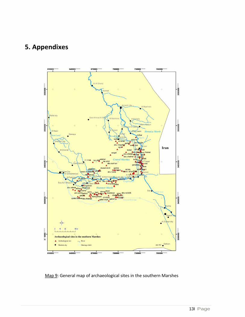
Map 9: General map of archaeological sites in the southern Marshes
14 | P a g e
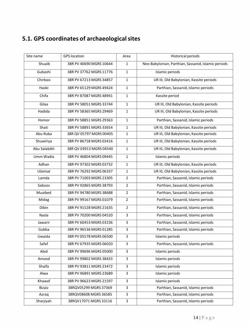
5.1. GPS coordinates of archaeological sites
Site name GPS location Area Historical periods
Shuaib 38R PV 40690 MGRS 10644 1 Neo-Babylonian, Parthian, Sassanid, Islamic periods
Gubashi 38R PV 37762 MGRS 11776 1 Islamic periods
Chirbasi 38R PV 67213 MGRS 34857 1 UR III, Old Babylonian, Kassite periods
Hasbi 38R PV 65129 MGRS 49424 1 Parthian, Sassanid, Islamic periods
Chifa 38R PV 87087 MGRS 48941 1 Kassite period
Gilaa 38R PV 58051 MGRS 33744 1 UR III, Old Babylonian, Kassite periods
Hadida 38R PV 58365 MGRS 29469 1 UR III, Old Babylonian, Kassite periods
Homor 38R PV 58851 MGRS 29363 1 Parthian, Sassanid, Islamic periods
Shati 38R PV 58891 MGRS 33654 1 UR III, Old Babylonian, Kassite periods
Abu Ruba 38R QV 05797 MGRS 00405 1 UR III, Old Babylonian, Kassite periods
Shuwiriya 38R PV 86758 MGRS 03416 1 UR III, Old Babylonian, Kassite periods
Abu Salabikh 38R QV 03913 MGRS 04540 1 UR III, Old Babylonian, Kassite periods
Umm Wadia 38R PV 46804 MGRS 09445 1 Islamic periods
Adhan 38R PV 97302 MGRS 03732 1 UR III, Old Babylonian, Kassite periods
Ulaimat 38R PV 76292 MGRS 06337 1 UR III, Old Babylonian, Kassite periods
Lamda 38R PV 71003 MGRS 23305 2 Parthian, Sassanid, Islamic periods
Saboos 38R PV 92865 MGRS 38793 2 Parthian, Sassanid, Islamic periods
Muaibed 38R PV 94780 MGRS 38688 2 Parthian, Sassanid, Islamic periods
Midag 38R PV 99167 MGRS 01079 2 Parthian, Sassanid, Islamic periods
Dibin 38R PV 91528 MGRS 21635 2 Parthian, Sassanid, Islamic periods
Nasla 38R PV 70200 MGRS 04520 3 Parthian, Sassanid, Islamic periods
Jawarir 38R PV 60453 MGRS 03236 3 Parthian, Sassanid, Islamic periods
Gubba 38R PV 96536 MGRS 01285 3 Parthian, Sassanid, Islamic periods
Uwaida 38R PV 05578 MGRS 06500 3 Islamic periods
Safaf 38R PV 67935 MGRS 06020 3 Parthian, Sassanid, Islamic periods
Abid 38R PV 99696 MGRS 05000 3 Islamic periods
Amood 38R PV 99802 MGRS 38433 3 Islamic periods
Shaifa 38R PV 93811 MGRS 23472 3 Islamic periods
Alwa 38R PV 96891 MGRS 23689 3 Islamic periods
Khawaf 38R PV 96623 MGRS 21597 3 Islamic periods
Bizaiz 38RQV05299 MGRS 37369 3 Parthian, Sassanid, Islamic periods
Azraq 38RQV08608 MGRS 36585 3 Parthian, Sassanid, Islamic periods
Sharjiyah 38RQV17071 MGRS 33116 3 Parthian, Sassanid, Islamic periods

15 | P a g e
Brais 38RQV20334 MGRS 34097 3 Parthian, Sassanid, Islamic periods
Ganasiyah 38RQV21732 MGRS 33705 3 Parthian, Sassanid, Islamic periods
Snaien 38RQV21217 MGRS 29118 3 Islamic periods
Ramla 38RQV21487 MGRS 35005 3 Parthian, Sassanid, Islamic periods
Saibaiya 38RQV23940 MGRS 36820 3 Parthian, Sassanid, Islamic periods
Saigal 38RPV89450 MGRS 59568 4 Parthian, Sassanid, Islamic periods
Agor 38RQV06273 MGRS 58948 4 Parthian, Sassanid, Islamic periods
Abu Shather 38RPV98986 MGRS 67166 4 Parthian, Sassanid, Islamic periods
Kobar 38RQV11157 MGRS 63445 4 Parthian, Sassanid, Islamic periods
Abu Shidhafi 38RQV19452 MGRS 63600 4 Parthian, Sassanid, Islamic periods
Abu Mughairfat 38RQV05420 MGRS 70345 4 Parthian, Sassanid, Islamic periods
Gubab 38RQV07901 MGRS 72903 4 Parthian, Sassanid, Islamic periods
Shaien 38RQV07901 MGRS 72903 4 Islamic periods
Abu Sharabi 38RQV21080 MGRS 73523 4 Parthian, Sassanid, Islamic periods
Mathar 38RQV24414 MGRS 83912 4 Parthian, Sassanid, Islamic periods
Umm Doub 38RQV3072464482 MGRS 5 Islamic periods
Umm Dood 38RQV28336 MGRS 63272 5 Islamic periods
Abu Zowair 38RQV22122 MGRS 60295 5 Parthian, Sassanid, Islamic periods
Madinah 38RQV23529 MGRS 57123 5 Parthian, Sassanid, Islamic periods
Homer 38RQV36022 MGRS 60295 5 Parthian, Sassanid, Islamic periods
Qaser Bani Malik 38RQV29416 MGRS 56730 5 Islamic periods
Limama 38RQV29416 MGRS 56730 5 Islamic periods
Routa 38RQV34420 MGRS 47573 5 Parthian, Sassanid, Islamic periods
Nakhala 38RQV34420 MGRS 47573 5 Islamic periods
Hamayoun 38RQV33864 MGRS 44956 5 Parthian, Sassanid, Islamic periods
Abu Uran 38RQV31089 MGRS 43781 5 Parthian, Sassanid, Islamic periods
Hemian 38RQV33315 MGRS 35281 5 Islamic periods
16 | P a g e
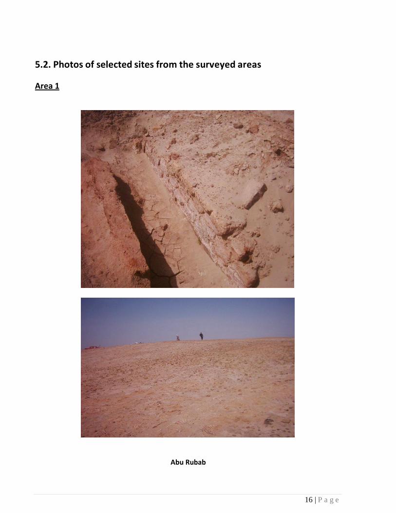
5.2. Photos of selected sites from the surveyed areas Area 1
Abu Rubab

17 | P a g e
Abu Thahab

18I Page
Abu Shuiab

191 Page
Area 2
Midag

20 | P a g e
Area 3
Abu Nasla

21 [ Page
Gubba
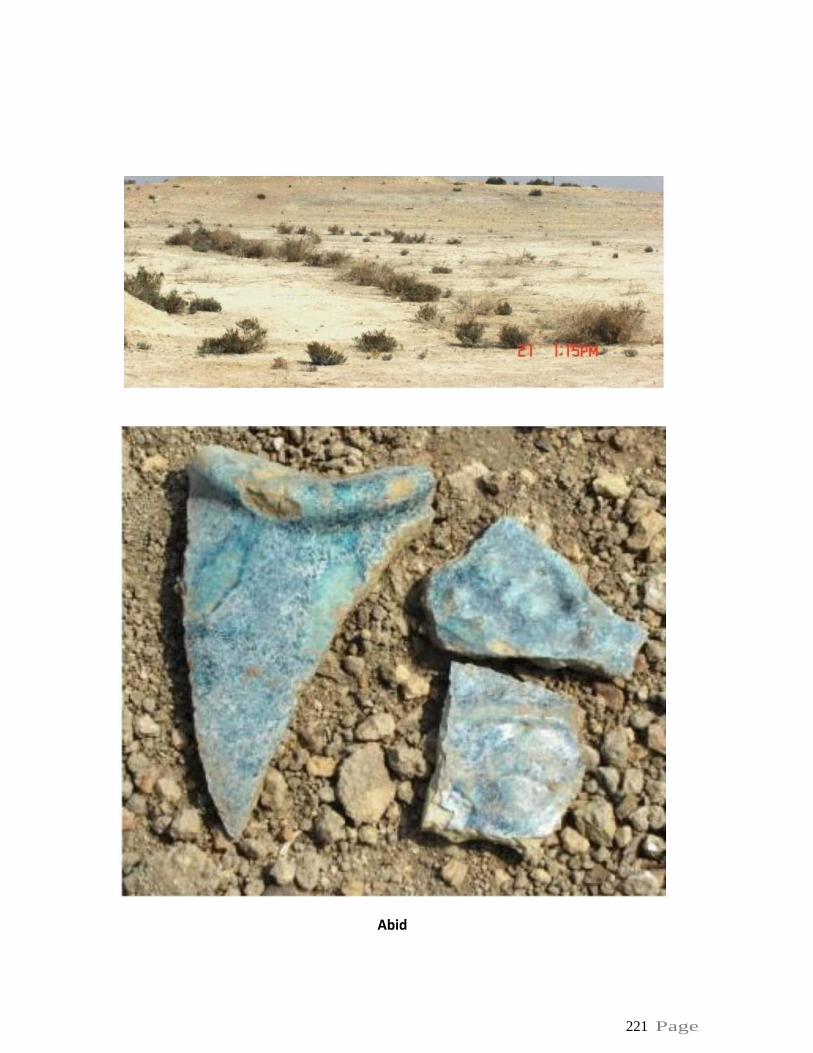
221 Page
Abid

23 | P a g e
Musaihib

24 | P a g e
Musaihib

25 | P a g e
Brais
26 | P a g e
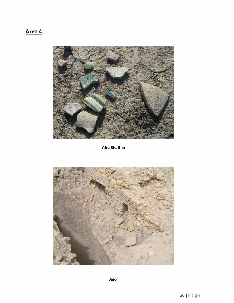
Area 4
Abu Shather
Agor

27 | P a g e
Area 5
Madina

28 | P a g e
Madina
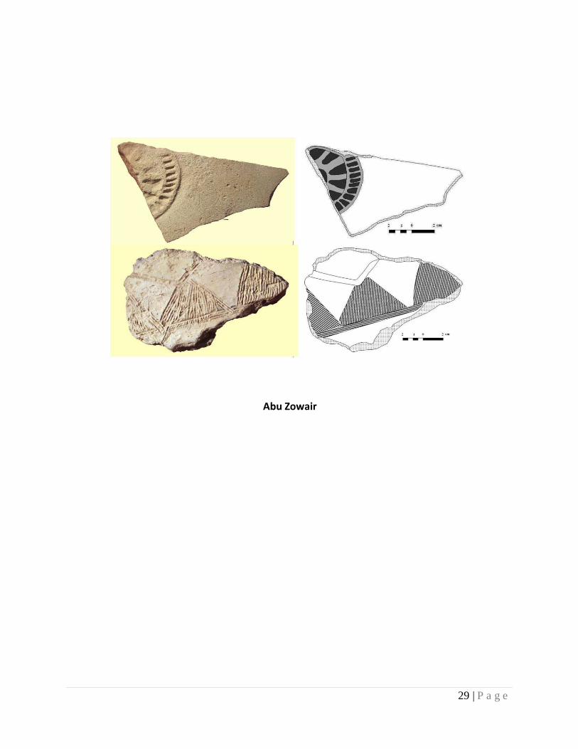
29 | P a g e
Abu Zowair