Fenay Beck Part II: Advisory Visit for Calder & Colne ... · 2 1 Introduction Following an initial...
16
1 Fenay Beck Part II: Advisory Visit for Calder & Colne Rivers Trust Report by the Wild Trout Trust Arising from Visit on 20/06/2017 Fenay Beck (Visit II), Fenay Bridge to source River Fenay Beck Waterbody Name Fenay Beck from Source to River Colne Waterbody ID GB104027063340 Management Catchment Aire and Calder River Basin District Humber Current Ecological Quality Moderate U/S Grid Ref inspected SE2127110269 D/S Grid Ref inspected SE1824715394 Length of river inspected 5.5km
Transcript of Fenay Beck Part II: Advisory Visit for Calder & Colne ... · 2 1 Introduction Following an initial...
1
Fenay Beck Part II: Advisory Visit for Calder & Colne Rivers Trust
Report by the Wild Trout Trust Arising from Visit on 20/06/2017
Fenay Beck (Visit II), Fenay Bridge to
source
River Fenay Beck
Waterbody Name Fenay Beck from Source to River Colne
Waterbody ID GB104027063340
Management Catchment Aire and Calder
River Basin District Humber
Current Ecological Quality Moderate
U/S Grid Ref inspected SE2127110269
D/S Grid Ref inspected SE1824715394
Length of river inspected 5.5km
2
1 Introduction
Following an initial site visit (detailed in Report “Fenay Beck Part I: Advisory Visit for Calder & Colne Rivers Trust) a further habitat appraisal was carried out by Dr. Paul Gaskell of the Wild Trout Trust (WTT). The second visit was requested and
hosted by Judith Milner of Calder and Colne Rivers Trust, to explore the potential for habitat improvement on the mid-to-upper reaches of the Fenay Beck between
Fenay Bridge and its source (called Shepley Dike) between Lower Cumberworth and Shelley. The Water Framework Directive (WFD) identifies the Fenay Beck as an individual waterbody via the code GB104027063340. It is formally classed
as a “Heavily Modified Waterbody” under WFD.
The most recent (2016, Cycle 2) WFD assessments conducted to assess the ecological status of this waterbody show that, while “good” for overall chemical quality, the current overall waterbody rating is “moderate”. Biological elements
such as fish and invertebrates and the physico-chemical element phosphate are notable factors in the classification (all “moderate”). In contrast, dissolved oxygen,
pH, ammonia and biochemical oxygen demand are all rated as “high”. One surprising scoring, given the impoundments and impacts of channel realignments observed during the visit, is the “supports good” rating given to the
hydromorphological supporting elements of the Fenay Beck.
Superficial geology in the catchment consists of alluvium, clay, silt and sand associated with the river corridor within a broader context of glacial sand and
gravel. Bedrock is Pennine Lower Coal Measures Formation and South Wales Lower Coal Measures Formation which is described as “interbedded grey mudstone, siltstone and pale grey sandstone, commonly with mudstones containing marine
fossils in the lower part, and more numerous and thicker coal seams in the upper part” according to the British Geological Survey. At the source, there was notable
input of ochre, a typical factor associated with coal-seam groundwater, producing an orange coating to the bed of the Beck.
Throughout this Advisory Visit report, normal convention is followed with respect to bank identification i.e. banks are designated Left Bank (LB) or Right Bank (RB)
whilst looking downstream. The features noted during the visit are reported here in an upstream to downstream sequence. The survey was conducted between limits at National Grid Reference SE 21271 10269 (upstream limit) and SE
18247 15394 (downstream limit). Consequently, approximately 5.5 km of river habitat was assessed.
The findings in this report are a combination of information supplied by Judith Milner prior to, during and following the visit and our inspection of habitat on the
day.
2 Habitat Assessment Notes
At the downstream limit of the visited reach for this report, a bridge crosses the stream behind the premises of a local business at SE 18247 15394 (Fig.1). Although the path of the channel has been historically altered to accommodate
land-use and development, the river corridor has recovered some valuable habitat features. These have arisen from processes of erosion and deposition within the
channel and the development of natural riparian woodland vegetation. In the

3
absence of polluted or over-abstracted water, these conditions should give rise to valuable biological communities and food-webs within the river corridor.
Figure 1: A lack of impoundment and some "benign neglect" have allowed
valuable habitat to develop naturally. Note, though, a low-level presence of the
invasive/non-native plant Himalayan balsam and the unseasonally low flows.
Although quite narrow, there is at least some buffer provided by the corridor of
woodland surrounding the stream in these reaches. The photographs at this point (Fig. 1 facing upstream and Fig. 2 facing downstream) show the low flows due to the extremely low rainfall leading up to the visit.
Figure 2: The artificial bend produced by the wall is at least providing an
opportunity for pool habitat to develop by encouraging the river to scour down
into the bed - rather than laterally into the bank.
4
One valuable function of deep root systems associated with diverse woodland vegetation is to create resistance to bank-erosion. In Figure 2, such increased resistance to bank erosion has been artificially provided by the stone wall on the
outside of an engineered bend. On the one hand, the combination of the bend (speeding flows on the outside of the curve) and resistance to erosion (dense,
natural stone) forces the river to erode the bed at this location. The result is a “self-cleaning” pool on the outside of the bend – and considerable variation in
depth and current velocity over the cross-section of the channel. On the other hand, in natural banks on woodland streams; the resistance provided
by tree root systems creates such pool habitat and often provides excellent cover habitat in the form of submerged roots. At the same time, the varied root-
structure (and periodic loss) of trees means that some bank erosion still occurs in a patchy fashion. That bank erosion is the natural means by which gravel enters streams and rivers. When bank erosion is completely stopped, the supply of that
material (an important resource for many species, including trout) is cut off. However, as is discussed later in this report, the Fenay Beck upstream of the more
developed/urban areas also runs through grazing land that has some very high bank erosion rates.
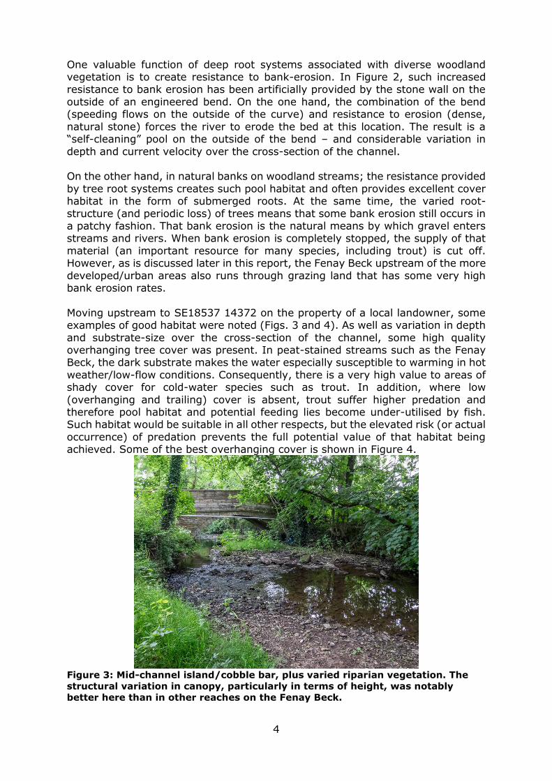
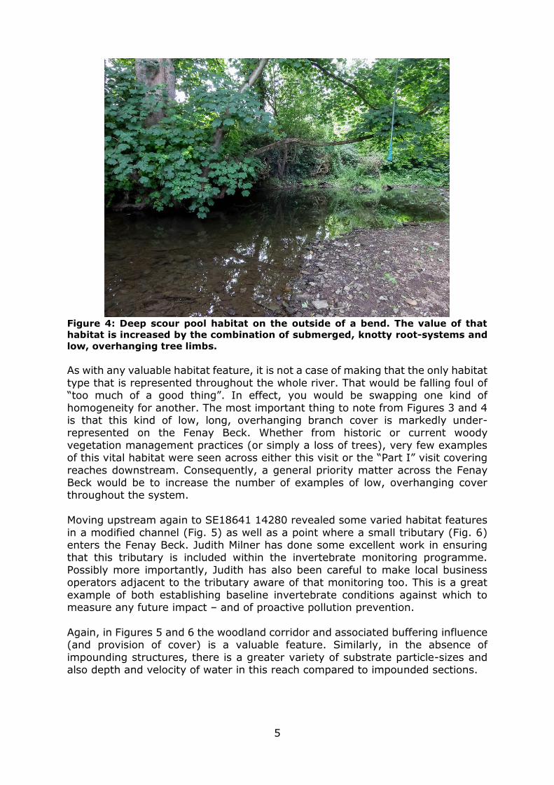
Moving upstream to SE18537 14372 on the property of a local landowner, some examples of good habitat were noted (Figs. 3 and 4). As well as variation in depth
and substrate-size over the cross-section of the channel, some high quality overhanging tree cover was present. In peat-stained streams such as the Fenay Beck, the dark substrate makes the water especially susceptible to warming in hot
weather/low-flow conditions. Consequently, there is a very high value to areas of shady cover for cold-water species such as trout. In addition, where low
(overhanging and trailing) cover is absent, trout suffer higher predation and therefore pool habitat and potential feeding lies become under-utilised by fish. Such habitat would be suitable in all other respects, but the elevated risk (or actual
occurrence) of predation prevents the full potential value of that habitat being achieved. Some of the best overhanging cover is shown in Figure 4.
Figure 3: Mid-channel island/cobble bar, plus varied riparian vegetation. The
structural variation in canopy, particularly in terms of height, was notably
better here than in other reaches on the Fenay Beck.
5
Figure 4: Deep scour pool habitat on the outside of a bend. The value of that
habitat is increased by the combination of submerged, knotty root-systems and
low, overhanging tree limbs.
As with any valuable habitat feature, it is not a case of making that the only habitat
type that is represented throughout the whole river. That would be falling foul of “too much of a good thing”. In effect, you would be swapping one kind of
homogeneity for another. The most important thing to note from Figures 3 and 4 is that this kind of low, long, overhanging branch cover is markedly under-represented on the Fenay Beck. Whether from historic or current woody
vegetation management practices (or simply a loss of trees), very few examples of this vital habitat were seen across either this visit or the “Part I” visit covering
reaches downstream. Consequently, a general priority matter across the Fenay Beck would be to increase the number of examples of low, overhanging cover throughout the system.
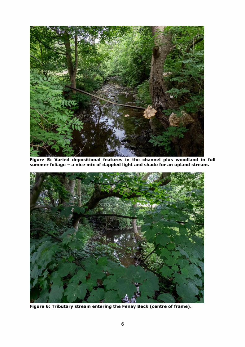
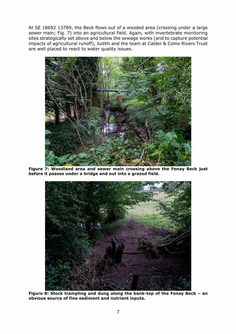
Moving upstream again to SE18641 14280 revealed some varied habitat features
in a modified channel (Fig. 5) as well as a point where a small tributary (Fig. 6) enters the Fenay Beck. Judith Milner has done some excellent work in ensuring that this tributary is included within the invertebrate monitoring programme.
Possibly more importantly, Judith has also been careful to make local business operators adjacent to the tributary aware of that monitoring too. This is a great
example of both establishing baseline invertebrate conditions against which to measure any future impact – and of proactive pollution prevention.
Again, in Figures 5 and 6 the woodland corridor and associated buffering influence (and provision of cover) is a valuable feature. Similarly, in the absence of
impounding structures, there is a greater variety of substrate particle-sizes and also depth and velocity of water in this reach compared to impounded sections.
6
Figure 5: Varied depositional features in the channel plus woodland in full
summer foliage – a nice mix of dappled light and shade for an upland stream.
Figure 6: Tributary stream entering the Fenay Beck (centre of frame).
7
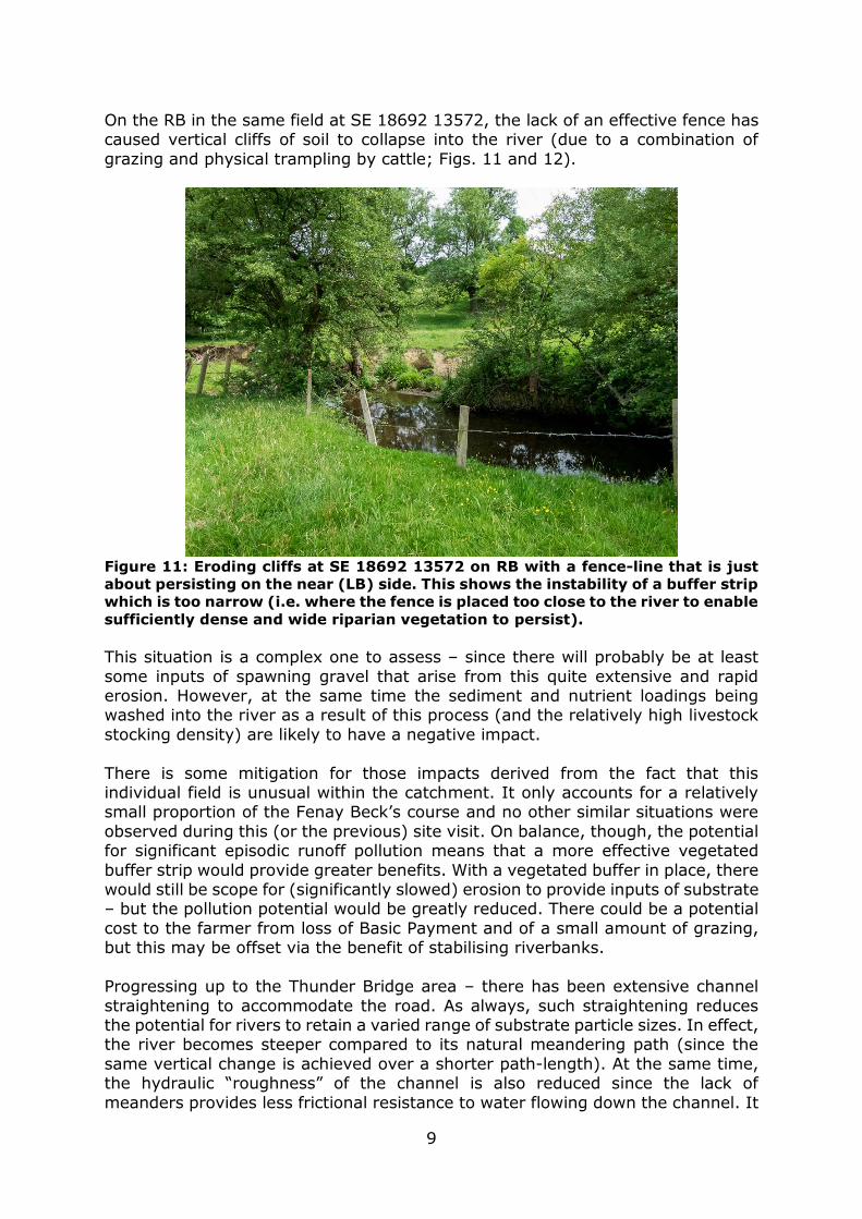
At SE 18692 13789, the Beck flows out of a wooded area (crossing under a large sewer main; Fig. 7) into an agricultural field. Again, with invertebrate monitoring sites strategically set above and below the sewage works (and to capture potential
impacts of agricultural runoff), Judith and the team at Calder & Colne Rivers Trust are well placed to react to water quality issues.
Figure 7: Woodland area and sewer main crossing above the Fenay Beck just
before it passes under a bridge and out into a grazed field.
Figure 8: Stock trampling and dung along the bank-top of the Fenay Beck – an
obvious source of fine sediment and nutrient inputs.

8
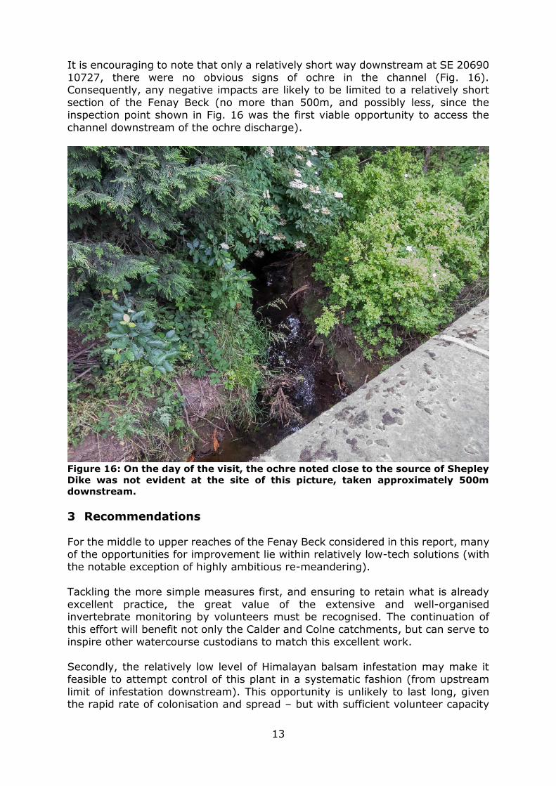
Some immediate issues that were evident during the site visit included an area of stock trampling and dung (Fig. 8) that has a direct route down a steep slope (Fig.
9) into the Beck at SE18692 13789 during wet weather.
Figure 9: Steep gulley adjacent to the brick wall leads straight down from the
stock-trampled area into the Beck.
A fenced buffer strip that would allow vegetation to establish on the bank top may
provide some vital filtration of sediment and nutrients. Ideally, this would prevent the pollution associated with runoff entering the Beck in wet weather at this location. Although narrower than would be ideal, the buffer strip in the field
downstream of the features photographed in Fig. 9 is providing a small degree of this type of protection (Fig. 10). This is maintained by a fence on the LB in this
field – which is placed as close as physically possible to the watercourse.
Figure 10: Narrow vegetated buffer strip - providing a small amount of filtration
of runoff - but also limiting runaway bank erosion (due to deeper root system
compared to turf).
9
On the RB in the same field at SE 18692 13572, the lack of an effective fence has caused vertical cliffs of soil to collapse into the river (due to a combination of
grazing and physical trampling by cattle; Figs. 11 and 12).
Figure 11: Eroding cliffs at SE 18692 13572 on RB with a fence-line that is just
about persisting on the near (LB) side. This shows the instability of a buffer strip
which is too narrow (i.e. where the fence is placed too close to the river to enable
sufficiently dense and wide riparian vegetation to persist).
This situation is a complex one to assess – since there will probably be at least
some inputs of spawning gravel that arise from this quite extensive and rapid erosion. However, at the same time the sediment and nutrient loadings being washed into the river as a result of this process (and the relatively high livestock
stocking density) are likely to have a negative impact.
There is some mitigation for those impacts derived from the fact that this individual field is unusual within the catchment. It only accounts for a relatively small proportion of the Fenay Beck’s course and no other similar situations were
observed during this (or the previous) site visit. On balance, though, the potential for significant episodic runoff pollution means that a more effective vegetated
buffer strip would provide greater benefits. With a vegetated buffer in place, there would still be scope for (significantly slowed) erosion to provide inputs of substrate – but the pollution potential would be greatly reduced. There could be a potential
cost to the farmer from loss of Basic Payment and of a small amount of grazing, but this may be offset via the benefit of stabilising riverbanks.
Progressing up to the Thunder Bridge area – there has been extensive channel
straightening to accommodate the road. As always, such straightening reduces the potential for rivers to retain a varied range of substrate particle sizes. In effect, the river becomes steeper compared to its natural meandering path (since the
same vertical change is achieved over a shorter path-length). At the same time, the hydraulic “roughness” of the channel is also reduced since the lack of
meanders provides less frictional resistance to water flowing down the channel. It

10
is that friction which slows water and promotes areas of deposition. In a natural meandering channel, there is much greater contrast between the conditions on the inside of each bend (shallow depositional features) and the outside (scour pool
habitat). Without those meanders, there is little scope for the left and right bank conditions to differ throughout a straightened reach leading to a reduction in the
physical variety of habitat. In other words, homogenising the potential for deposition and remobilisation of substrate leads to far less potential for variation
in depth and velocity over the cross-section of a river when it has been straightened (Figs. 12 and 13).
Because these modifications were made to accommodate roads and other permanent infrastructure, it often becomes exceptionally difficult to re-meander
such sections of river. However, it is worth exploring any possible scope for reintroduction of meanders. For instance, there may be some locations where land on the opposite side of the river to the main infrastructure could be more easily
reclaimed – allowing meanders to be re-created. As a lesser/fallback position, it may be possible to create some in-channel variety by “dig and dump”
redistribution of the channel substrate within its current confines. The challenge there is to stabilise and retain that structural change within the channel (may be possible via pinned “rock rolls” and back-filled berms).
Figure 12: Notice the homogenous depth and flow across the full width of the
channel (and resulting lack of differentiation between LB and RB conditions).
Although the RB (left of frame) has clearly been conformed to the road, there
may be some instances where land-use on the opposite bank could potentially
accommodate a stream with a more meandering planform.

11
Figure 13: Facing downstream off the bridge at SE 18816 11406 - the river is
constrained between property and road – but some lush vegetation and a little
variety in the substrate structure provide some varied habitat. The substrate
variation has developed due to the generally steep longitudinal bed-slope (which
promotes mobilisation and deposition of a wider range of substrate than in lower
gradient streams).
Following a substantial jump upstream (to the source of the Fenay Beck system known as Shepley Dike at SE21271 10269), some final observations were made.
Obviously at these very headwater areas, the character of the watercourse is significantly different – being a wetland ditch habitat (Fig. 14). However, the coal-seam geology noted at the start of this report shows its influence here in the form
of ochreous deposits in the stream-bed (Fig. 15). When water that is derived from the coal-measures issues out at the surface, it carries a cocktail of dissolved
minerals (and can be highly acidic). Often the most visible evidence of this is the dissolved form of iron oxide (Iron II oxide) which is green and highly soluble in water in anoxic conditions (i.e. in the absence of oxygen). However, as soon as
water carrying iron II oxide is exposed to the oxygen in the air, it oxidises to the orange iron III oxide that we easily recognise in rust. It is this “rust” that has
precipitated onto the riverbed (Fig. 15) to turn it orange. Although iron III oxide (ochre) is pretty inert (being essentially insoluble in water),
it does have a smothering effect on the riverbed and the flora and fauna that would otherwise live there. Depending on the acidity of the coal-measure water
(and the amount of dilution available in the receiving watercourse), that can also have a negative impact.

12
Figure 14: Close to the source of the Fenay Beck known as Shepley Dike - a good
riparian buffer strip and some valuable wetland vegetation.
Figure 15: Ochreous discharge - smothering the bed of Shepley Dike.
13
It is encouraging to note that only a relatively short way downstream at SE 20690 10727, there were no obvious signs of ochre in the channel (Fig. 16). Consequently, any negative impacts are likely to be limited to a relatively short
section of the Fenay Beck (no more than 500m, and possibly less, since the inspection point shown in Fig. 16 was the first viable opportunity to access the
channel downstream of the ochre discharge).
Figure 16: On the day of the visit, the ochre noted close to the source of Shepley
Dike was not evident at the site of this picture, taken approximately 500m
downstream.
3 Recommendations
For the middle to upper reaches of the Fenay Beck considered in this report, many of the opportunities for improvement lie within relatively low-tech solutions (with the notable exception of highly ambitious re-meandering).
Tackling the more simple measures first, and ensuring to retain what is already
excellent practice, the great value of the extensive and well-organised invertebrate monitoring by volunteers must be recognised. The continuation of
this effort will benefit not only the Calder and Colne catchments, but can serve to inspire other watercourse custodians to match this excellent work.
Secondly, the relatively low level of Himalayan balsam infestation may make it feasible to attempt control of this plant in a systematic fashion (from upstream
limit of infestation downstream). This opportunity is unlikely to last long, given the rapid rate of colonisation and spread – but with sufficient volunteer capacity
14
(comparable to that evident with the invertebrate monitoring) it may be worthwhile. By locating the furthest upstream infestation and starting to control it at that source (by simple hand-pulling and composting on site), it should be
possible to move that upstream limit downstream.
Even in the absence of the capacity to undertake “top down” systematic control, it is still extremely valuable to control infestations of Himalayan balsam in specific
areas – since this allows local patches of more diverse, native, vegetation to redevelop. At a broader landscape scale, those more diverse patches add up to a significant boon to native biodiversity.
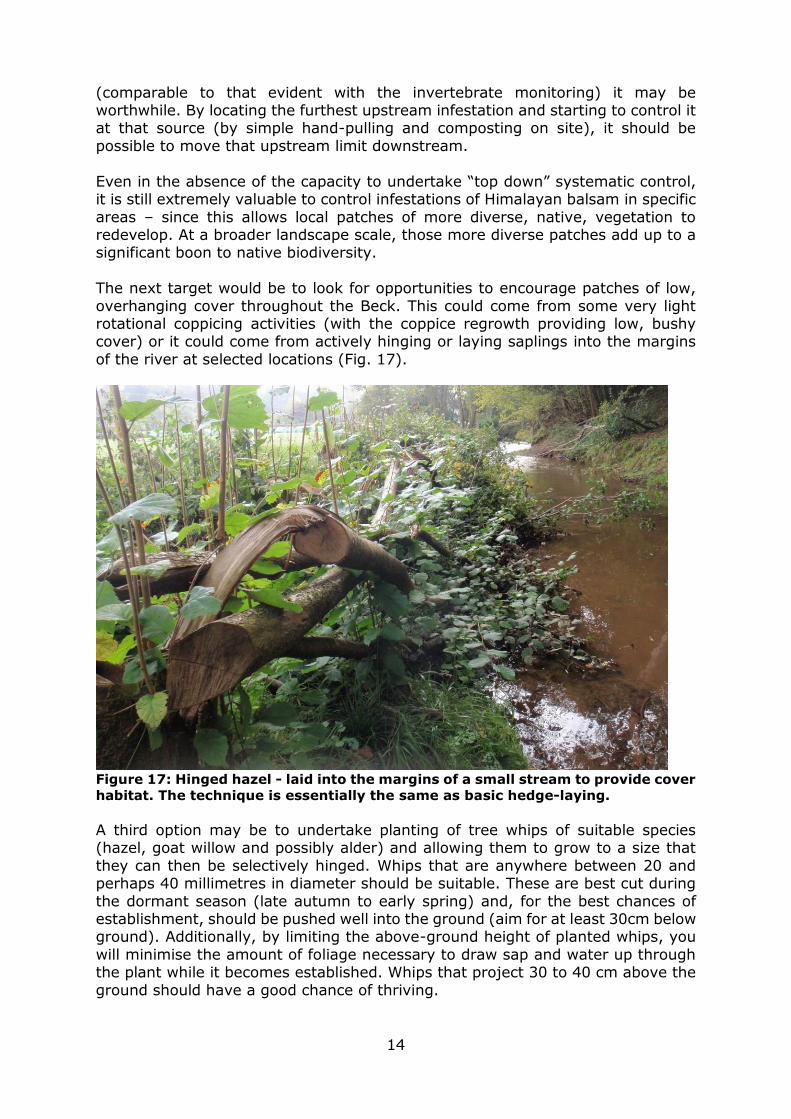
The next target would be to look for opportunities to encourage patches of low,
overhanging cover throughout the Beck. This could come from some very light rotational coppicing activities (with the coppice regrowth providing low, bushy cover) or it could come from actively hinging or laying saplings into the margins
of the river at selected locations (Fig. 17).
Figure 17: Hinged hazel - laid into the margins of a small stream to provide cover
habitat. The technique is essentially the same as basic hedge-laying.
A third option may be to undertake planting of tree whips of suitable species (hazel, goat willow and possibly alder) and allowing them to grow to a size that
they can then be selectively hinged. Whips that are anywhere between 20 and perhaps 40 millimetres in diameter should be suitable. These are best cut during
the dormant season (late autumn to early spring) and, for the best chances of establishment, should be pushed well into the ground (aim for at least 30cm below ground). Additionally, by limiting the above-ground height of planted whips, you
will minimise the amount of foliage necessary to draw sap and water up through the plant while it becomes established. Whips that project 30 to 40 cm above the
ground should have a good chance of thriving.
15
Another priority issue which has a relatively simple practical solution would be tackling the nutrient and sediment inputs in the sites pictured in Figs. 8 to 11. Excluding livestock for a greater distance from the stream is all that is needed in
a technical sense. This will allow a wider and more robust buffer strip to develop (and could even be aided with some tree planting). That buffer strip would also
slow the rate of bank erosion (a likely plus-point for land-owners). Provision of drinking water for stock via mains-fed troughs has been shown to reduce vet’s
bills due to lower instances of waterborne parasites and disease. Alternatively, it may be possible to install pasture pumps that supply water from the Beck on demand to points within the field that are on the livestock’s side of any exclusion
fence.
Finally, although potentially prohibitive due to the value or state of the surrounding land, the remaining significant benefit that could be achieved on these sections of the Fenay Beck would be a channel re-meandering project. As noted
in the Habitat Assessment section of this report, this would entail identifying potential areas that may be able to accommodate a re-meandered channel.
Undertaking that initial exercise is likely to be inexpensive and it should indicate with fair accuracy the specific cost implications of tackling any of the straightened reaches. In the instance that such approaches were deemed unfeasible, it may be
possible to undertake work that uses comparable techniques to those applied in the de-culverted Porter Brook in Sheffield city centre
(http://www.wildtrout.org/blog/catching-and-releasing - and see the first embedded video on that page from 2min 5 seconds for potentially-suitable berm-creation techniques).
In summary:
Tackle Himalayan balsam by hand-pulling and composting on site (either systematically or in targeted zones)
Identify and deliver scattered patches of low, overhanging cover throughout
the Beck (LIGHT coppicing, hinging and combined whip planting/hinging) Establish a functional buffer strip in livestock grazing field to prevent
excessive erosion and inputs of nutrients and sediment during wet weather Explore potential for re-meandering where land-use and land-ownership
may allow
In the absence of true re-meandering opportunities, recreate some meandering character within the channel constraints in reaches such as
those pictured in Figs. 12 and 13. Multiple permissions (beyond simple landowner permission) are likely to be
needed for all works suggested in this report and the WTT can advise on the typical permissions that it is aware of. There may also be additional permissions that the
WTT are as yet unaware of. That is where local knowledge and also the responsibility of anyone deciding to act on any advice within this report come into
play. Ongoing support in the pursuit of these various aims is available from the Trout
in the Town project manager (Paul Gaskell Email: [email protected] Tel: 07919 157267) and the rest of the Conservation Team at the WTT.
4 Acknowledgement

16
The WTT would like to thank the Environment Agency for supporting the advisory and project proposal work associated with this project – including a portion of funds arising from rod licence sales. Additional support for this specific visit was
also gratefully received from Calder & Colne Rivers Trust.
5 Disclaimer
This report is produced for guidance; no liability or responsibility for any loss or damage can be accepted by the Wild Trout Trust as a result of any other person,
company or organisation acting, or refraining from acting, upon guidance made in this report.