FEMA Risk MAP Style Guide An Introduction to Flood Risk · FEMA Risk MAP Style Guide 8 J u p i t e...
2
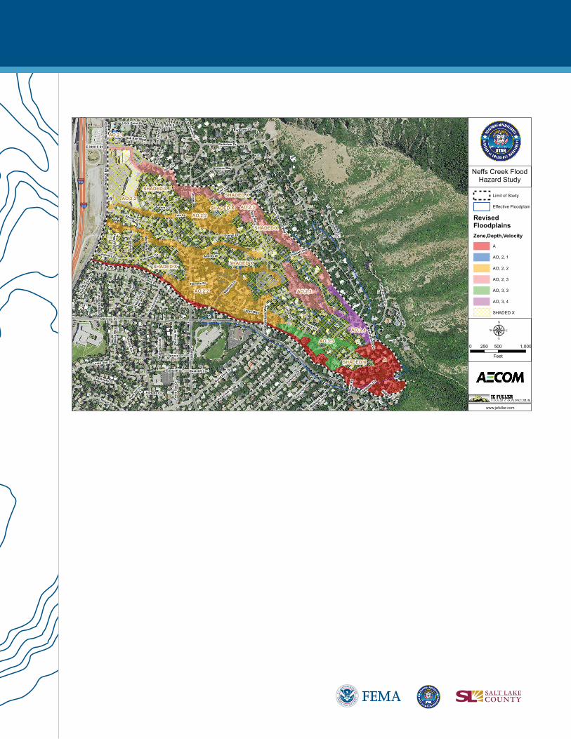
FLOODS AND FLASHFLOODS DEFINED Flooding is a condition where water or mud overflows onto land that is normally dry. Flooding is the most common and widespread weather-related natural disaster in the U.S. and can occur with little or no warning. Active alluvial fans, like the one at Neff’s Canyon, lack a single defined flow path and are prone to sudden, fast, and unpredictable floods, called flash floods. Flash floods most often occur following intense rainfall when excessive water from creeks and rivers fills dry creeks and river beds. DETERMINING FLOOD RISK To identify a community’s flood risk, the Federal Emergency Management Agency (FEMA) conducts and manages a Flood Insurance Study. These studies include data for water flow rate and flow velocity, as well as surveys of rainfall and area topography. Flood Insurance Studies are then used to create flood hazard maps that outline a community’s flood risk areas. INSURANCE IMPLICATIONS OF FLOOD RISK FOR NEFF’S CANYON FEMA creates Flood Insurance Rate Maps (FIRMs), which show varying levels of risk. Preliminary (draft) flood maps for the Neff’s Creek area, which will be part of the larger Jordan Watershed study, are anticipated to be released in 2017. These maps will designate the following flood risk areas: High Risk Areas (Special Flood Hazard Area)—There is at least a one-in-four (or 26%) chance of flooding during a 30-year mortgage in these areas. Homeowners with mortgages from federally regulated or insured lenders are required to buy flood insurance to be protected from this risk. These areas are shown on flood maps as A and AO (alluvial fan hazards with water depth and velocity shown) zones. Moderate- to Low-Risk Areas (Non-Special Flood Hazard Area)—Flood risk in these areas is lower but still exists. Homeowners in these areas are not federally required to buy flood insurance, but it is highly recommended. These areas are shown on flood maps as X (or shaded X) zones. FLOOD RISK REVISIONS AND FLOOD MAPPING CHANGES Flood risk can, and does, change over time. Flood risk can change for many reasons, including land development, erosion, increasing storm intensity, wildfires, and other causes. As a result, FEMA is using the newest technologies to update flood maps across the country. The new maps will help residents in the vicinity of Neff’s Creek better understand their flood risk so they can take steps to protect their community and their homes. Once effective, the new maps will be used for community floodplain management and flood insurance rating purposes. An Introduction to Flood Risk FOR NEFF’S CREEK MAY 2016
-
Upload
truongdiep -
Category
Documents
-
view
222 -
download
0
Transcript of FEMA Risk MAP Style Guide An Introduction to Flood Risk · FEMA Risk MAP Style Guide 8 J u p i t e...

FEMA Risk MAP Style Guide
8
FLOODS AND FLASHFLOODS DEFINED Flooding is a condition where water or mud overflows onto land that is normally dry. Flooding is the most common and widespread weather-related natural disaster in the U.S. and can occur with little or no warning. Active alluvial fans, like the one at Neff’s Canyon, lack a single defined flow path and are prone to sudden, fast, and unpredictable floods, called flash floods. Flash floods most often occur following intense rainfall when excessive water from creeks and rivers fills dry creeks and river beds.
DETERMINING FLOOD RISK To identify a community’s flood risk, the Federal Emergency Management Agency (FEMA) conducts and manages a Flood Insurance Study. These studies include data for water flow rate and flow velocity, as well as surveys of rainfall and area topography. Flood Insurance Studies are then used to create flood hazard maps that outline a community’s flood risk areas.
INSURANCE IMPLICATIONS OF FLOOD RISK FOR NEFF’S CANYON FEMA creates Flood Insurance Rate Maps (FIRMs), which show varying levels of risk. Preliminary (draft) flood maps for the Neff’s Creek area, which will be part of the larger Jordan Watershed study, are anticipated to be released in 2017. These maps will designate the following flood risk areas:
High Risk Areas (Special Flood Hazard Area)—There is at least a one-in-four (or 26%) chance of flooding during a 30-year mortgage in these areas. Homeowners with mortgages from federally regulated or insured lenders are required to buy flood insurance to be protected from this risk. These areas are shown on flood maps as A and AO (alluvial fan hazards with water depth and velocity shown) zones.
Moderate- to Low-Risk Areas (Non-Special Flood Hazard Area)—Flood risk in these areas is lower but still exists. Homeowners in these areas are not federally required to buy flood insurance, but it is highly recommended. These areas are shown on flood maps as X (or shaded X) zones.
FLOOD RISK REVISIONS AND FLOOD MAPPING CHANGES Flood risk can, and does, change over time. Flood risk can change for many reasons, including land development, erosion, increasing storm intensity, wildfires, and other causes. As a result, FEMA is using the newest technologies to update flood maps across the country. The new maps will help residents in the vicinity of Neff’s Creek better understand their flood risk so they can take steps to protect their community and their homes. Once effective, the new maps will be used for community floodplain management and flood insurance rating purposes.
An Introduction to Flood RiskFOR NEFF’S CREEK
MAY 2016
FEMA Risk MAP Style Guide
8
Jupi
ter D
r
Oakview Dr
Parkview Dr
Fortu
na W
ay
Adonis Dr
Ruth Dr
Ceres Dr
Was
atch
Blv
d
Mount O
lympus W
ay
Hal
e D
r
Brockbank Dr
Gary Rd
Dia
na W
ay
Apollo Dr
Viewcrest Dr
Lares Way
Ach
illes
Dr
Lois Ln
Hermes Dr
Mathews Way
Eastcliff Dr
Evelyn Dr
Abi
nadi
Rd
Zarahemla D
r
Neptu
ne D
r
Barbara Way
Roger Dr
Eastoaks Dr
Spruce Dr
Oak Rim Way
Covecre
st Dr
Powers Cir
Bro
ckba
nk W
ay
Loren Von Dr
Park Terrace DrM
ars
Way
Foubert Ave
Suns
et V
iew
Dr
Spruce Cir
Park H
ill Dr
Pin
Oak
St
White W
ay
Cove Point Dr
Cre
st O
ak D
r
Mul
holla
nd S
t
E 3820 S
Oly
mpu
s Vi
ew D
r
S Parkview DrW
asat
ch D
r
Aurora Cir
Plut
o W
ay
E 3900 S St
Clif
f Dr
Lares Cir
Parkview Cir
Juno Cir
Eastcliff Cir
Fortuna CirHagoth Cir
Helaman Cir
Adonis Cir
Hermes Cir
Lois Ln
Parkvie
w Dr
Hermes Dr
Mars W
ay
Adonis Dr
Dia
na W
ay
§̈¦215
§̈¦215
A
AO,2,1
AO,2,2
AO,2,2
AO,2,2
AO,2,3
AO,2,3
AO,3,3
AO,3,4
SHADED X
SHADED X
SHADED X
SHADED X
SHADED X
SHADED X
SHADED X
Neffs Creek FloodHazard Study
Limit of Study
Effective Floodplain
RevisedFloodplainsZone,Depth,Velocity
A
AO, 2, 1
AO, 2, 2
AO, 2, 3
AO, 3, 3
AO, 3, 4
SHADED X
0 500 1,000250
Feet
µ
www.jefuller.com


![RBI/FED/2017-18/60 (updated up to March 08, 2019) (updated ... · Notification No. FEMA 20(R)/2017-RB of November 7, 2017, [FEMA 20(R)]. 1.2 An investment made by a person resident](https://static.fdocuments.us/doc/165x107/5f1428818c3a5d78a710c0ec/rbifed2017-1860-updated-up-to-march-08-2019-updated-notification-no.jpg)