Feasibility Report, 8-Acre Site in South Norfolk
14
American Engineering Associates – Southeast, PA, Inc. Virginia Engineering License 0405001994 448 Viking Drive, Suite 170, Virginia Beach, VA 23452 757-468-6800 www.American-EA.com Feasibility Report, 8-Acre Site in South Norfolk (Liberty Street, Seaboard Avenue & 20 th Street) for the City of Chesapeake, Virginia June 7, 2016
Transcript of Feasibility Report, 8-Acre Site in South Norfolk
American Engineering Associates – Southeast, PA, Inc. Virginia Engineering License 0405001994 448 Viking Drive, Suite 170, Virginia Beach, VA 23452 757-468-6800 www.American-EA.com
Feasibility Report, 8-Acre Site in South Norfolk (Liberty Street, Seaboard Avenue & 20th Street)
for the City of Chesapeake, Virginia
June 7, 2016
Feasibility Report, 8-acre site, South Norfolk Page 1
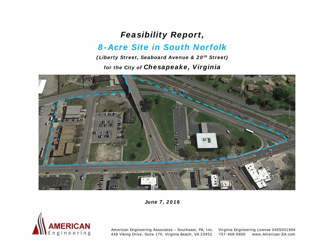
I. SUMMARY: A. As of the date of this report, the subject Property consists of the following four tax parcels at the addresses noted:
1. Tax Parcel 1231003000150, 901 Liberty Street, 2.84 acres, the site of the now-closed Bank of America branch.
2. Tax Parcel 1231003000001, 1202 20th Street, 1.95 acres, formerly the site of several civic buildings, now just the Chesapeake Community Corrections Agency (CCA) unit of the Human Services Department.
3. Tax Parcel 1231003000002 and 709 Liberty Street, 0.37 acre, formerly the site of a court building
4. Tax Parcel 1231003000080, 1201 20th Street, 1.04 acres, currently the site of Chesapeake Fire Station #1, 2nd Police Precinct Office and a satellite Treasurer’s Office facility.
B. The City of Chesapeake is planning to replace the aged “22nd Street Overpass,” which currently separates the Bank of America Parcel from the CCA Parcel with a new bridge whose southwestern approach end will be shifted eastward to align with existing Poindexter Street to make a new four-way intersection with Liberty Street. Portions of existing Seaboard Avenue and 20th Street may be closed and vacated. The gross acreage of the Study Area for this Feasibility Report is about 8.67 acres, depending on the extent of right of way areas to be closed. After dedication of a new right of way for the bridge approach across the Bank of America site, the remaining developable area of the Property will be approximately 7.44 acres. Nominal references to the site as “the 8 Acre Site” are just that—general and nominal. Of the 7.44 acres, 6.31 acres lie west of the relocated road and 1.13 acres east.
Feasibility Report, 8-acre site, South Norfolk Page 2
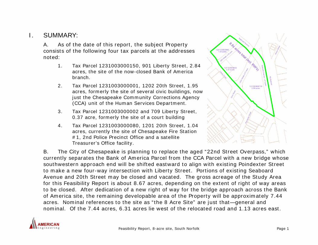
C. The contemplated use(s) for the Property include a modern civic buildings complex, possibly including some associated supporting retail and/or office spaces. Such redevelopment would fulfill, in significant part, recommendations contained in the more recent studies on revitalizing South Norfolk performed for the City of Chesapeake:
1. “Create a Village Center to re-establish a traditional downtown at Poindexter and Liberty.” -- Poindexter Corridor Strategic Study, led by Urban Design Associates, 2004-2006.
2. “Acquire control of 1-2 key commercial properties at Liberty and Poindexter.” -- A Technical Assistance Panel (TAP) Report, Poindexter Street Corridor and the Historic District in South Norfolk, Chesapeake, VA, Urban Land Institute/Hampton Roads, March, 2012.
D. This Feasibility Report finds that such redevelopment of the Property is feasible, considering civil engineering and site planning considerations as well as land use regulations. It provides additional suggestions and guidance regarding the form of such redevelopment. It does not propose a specific mix of development types, nor does it address the “marketability” of specific land uses; these matters are left to architects and public leadership. Our detail findings are set forth in the following paragraphs.
Former Bank
Feasibility Report, 8-acre site, South Norfolk Page 3
II. THE PROPERTY: A. The Property Boundaries page of the Base Mapping furnished with this report (Appendix A) shows the boundaries of the four parcels which comprise the overall assemblage of property, along with the associated portions of the existing rights of way of 20th Street, 22nd Street and Seaboard Avenue which may lend themselves to being closed and vacated. Assuming all such portions are vacated, less the dedication of the relocated right of way for the 22nd Street Bridge Replacement, the total CAD-measured area of the site is 7.44 acres, as shown on the Base Mapping. B. Closing and vacating any or all of these rights of way would require the relocation or abandonment of several existing public and private utilities and other facilities. The cost of such potential relocation must be weighed against the additional development flexibility resulting from a “clean slate” without the rights of way constraining the location, size and shape of proposed buildings. This will be discussed in more detail under IV. ENGINEERING CONSIDERATIONS. C. The Base Mapping will be made available as an AutoCAD file to persons evaluating redevelopment options for the Property. The Base Mapping has been prepared based on the following:
1. Property surveying performed for Clark-Nexsen in support of their design of the 22nd Street Bridge Replacement Project, receipt of which is acknowledged with appreciation.
2. Subdivision and street dedication plats of record. 3. Title examination performed by BridgeTrust Title Group for American Engineering in
support of this Feasibility Report. 4. Construction Record Drawings (CRD’s) acquire from the Chesapeake Departments of
Public Utilities and Department of Development and Permits 5. GIS shapefiles provided by the Chesapeake Department of Public Works 6. Drainage studies and SWMM modeling associated with previous tasks performed by
American Engineering for the Department of Public Works.
Feasibility Report, 8-acre site, South Norfolk Page 4
7. Limited field surveying effort by American Engineering’s survey staff.
D. The title examination by BridgeTrust Title, mentioned in C.3 above, discovered that title to some portions of the Property does not vest in the City of Chesapeake, due apparently to incomplete and/or ineffective acquisitions and street closures more than 50 years ago. See the attached (Appendix C) letter from Robert G. Hofheimer, Jr. and accompanying Status of Title Report, both dated May 20, 2016. The areas in question are reflected on the Base Mapping. For full utilization of the Property, legal action will be required to rectify these deficiencies. E. This information regarding the Property is offered as sufficient for site planning purposes. Prior to the Final Design of any redevelopment, the developer of same should have current Topographic and ALTA/ACSM Land Title Surveying performed for the Property.
III. PLANNING AND ZONING: A. At the time of this Report, most of the Property is zoned to O&I, Office & Institutional District, as set forth in the Chesapeake Zoning Ordinance. Only the northeastern portion of Tax Parcel 12310030000801201 20th Street is zoned to the M-1, Light Industrial District. B. While both M-1 and O&I permit Municipal Buildings and Structures, we recommend that the entire Property be rezoned to the B-5, Urban Business District. B-5 permits Municipal Buildings and Structures, but also allows a much wider variety of office, retail and other uses. Additionally, B-5, having been expressly crafted for an urban setting such as this, has substantially more flexible parking provisions. Finally, B-5 allows, and in fact promotes, the more urban effect of minimal setbacks from street rights of way, which in turn allows for more efficient use of the Property. C. It is our experience that one- to three-story buildings with all parking provided on site, and with typical office and/or retail uses, can achieve floor area ratios (FAR’s) of about 8,000 square feet (sf) to 12,000 sf per acre. To be applicable, these ratios should be applied exclusive of the mostly-separated area south of the 22nd Street Bridge Replacement
Feasibility Report, 8-acre site, South Norfolk Page 5
alignment, especially in view of the likely utilization of that area for stormwater and landscaping purposes. D. B-5, as contrasted with B-1, B-2 and O&I, has no maximum building coverage. Thus, site planning becomes driven, in significant part, by the decision of how much on-site parking is appropriate for the Property to function well for both employees and “customers” of the buildings and facilities on the Property.
1. Per the Chesapeake Zoning Ordinance and many other sources, office buildings and many retail establishments have a functional need of about 3 to 5 parking spaces per thousand square feet (sp/ksf); we’ll use 4 sp/ksf for this Report. Note that this is a total parking need, not necessarily all of which may be provided on-site in B-5.
2. While on-street parking and public parking lots exist off nearby Poindexter Street, on-street parking is not expected to be made available on Liberty Street. The nearest existing public lots flank Phillips Street; their centroid is about 800’ from the centroid of the Property, a route that is rather long for convenience, requires crossing Liberty Street and does not yet enjoy a high sense of security.
3. The parking requirements set forth for the B-5 District are a very lean 1 space per 900 sf (1.11 sp/ksf) for office, retail and customer service space and 0.5 sp/ksf for “other” spaces. Excluded from these “lean” rations are several more intense uses which are required to be parked in accordance with the general provisions of the Zoning Ordinance (grocery stores, meeting halls, churches, motels/hotels, movie theaters, including drive-in theaters, restaurants and others; see §7-502.A.4.c(1)).
4. Accordingly, in view of the factors noted above, we recommend that an intermediate parking ratio of 3 sp/ksf be used.
5. This ratio should allow FAR’s along the lines of the following, allowing 35% for “green space” as defined below (these ratios should be applied only to the contiguous 6.31±acres northwest of the new bridge):
Feasibility Report, 8-acre site, South Norfolk Page 6
a) For 1-story buildings, 14,000 sf/acre b) For 2-story buildings, 18,000 sf/acre c) For 3-story buildings, 20,000 sf/acre
6. “Green space” as used above means everything but building and paved vehicular area coverage, and includes yards, plazas, walkways, etc.
7. A conceptual layout is provided with this Feasibility Report, showing a 2-story layout yielding about 18,300 sf/acre (Appendix B).
E. The preparers of this Feasibility Report do not bring architectural design skills to the effort. However, any analysis of the Feasibility of redeveloping this Property must include mention of the importance of aesthetic considerations if development of the Property is to contribute significantly to the revitalization of South Norfolk. It is not known at this time whether its developer will be the City, a private entity or a joint venture. In any case, strong design standards should be set forth, so the buildings on the Property evoke confidence, pride and hope from South Norfolk’s citizens.
IV. ENGINEERING AND ENVIRONMENTAL: A. The redevelopment of the Property requires adequate infrastructure be in place to support it. In the following paragraphs, we examine each aspect of the infrastructure systems in this portion of South Norfolk. B. Streets: The key streets affecting the property are Liberty Street and Poindexter Street/22nd Street. Seaboard Avenue and 20th Street are of lesser importance as discussed below, and City Council may choose to close and vacate them to consolidate the Property and improve redevelopment flexibility.
1. Laneage and Configuration: Liberty Street has a pavement width of about 44’ and is marked as four 11’ lanes; separate right and left turn lanes are not provided. North of 20th Street, the width drops to about 38’ and Liberty is marked as two southbound lanes and one northbound. 22nd Street is presently a 4-lane, undivided street across the existing overpass, and is proposed for reconstruction as a 2-lanes street, to match
Feasibility Report, 8-acre site, South Norfolk Page 7
Poindexter Street to the southwest. 20th Street and Seaboard Avenue are 2-lane streets. These streets generally have curb and gutter, with the gutter having been overlaid in some locations, and other having plain curb and no gutter.
2. Capacity: There are no capacity issues in the vicinity of the Property. Average Daily Traffic on Liberty Street in the vicinity fell from 7,952 vehicles per day (vpd) in 2008 to 7,264 vpd in 2011, with values steady around 4,500 vpd north of 20th Street in the same period. 22nd Street traffic was .5,590 vpd in 2011. (Volumes, Speeds, and Congestion on Major Roadways in Hampton Roads, Hampton Roads Transportation Planning Office (TPO), June, 2013.) Providing more than 2 through lanes would not be considered until volumes of this sort were approximately doubled. 20th Street and the portion of Seaboard Avenue south of 20th Street are not essential to the public street network and should be considered for being closed and vacated, and/or converted to parking areas.
3. Condition: The condition of Liberty Street pavement is generally good south of Poindexter, fair between Poindexter and 22nd, and good north of 22nd. Some block cracking is noted, along with some rough patches. However, there are no pavement condition deficiencies which warrant action ahead of normal periodic pavement milling and overlay. Public Works appears to have been diligently addressing cracked and settled sidewalks in the Liberty Street corridor. There are some curb and other concrete cracks and failures at the southern end of Liberty Street, which should be addressed prior to redevelopment of the Property, possibly in conjunction with the 22nd Street Bridge Replacement project. 20th Street, as well as the portion of Seaboard Avenue to remain (20th Street intersection and northward), are in generally good condition.
4. 22nd Street Bridge Replacement: The impending Bridge Replacement project is central to the contemplated redevelopment of the Property. Per discussion with City staff, to maximize the usable area of the Property, it is expected that the southwestern bridge approach fill will be contained with Mechanically-Stabilized Earth (MSE) walls, rather than have 2:1 fill slopes. With the contemplated new bridge geometry, Seaboard Avenue will end just south of 20th Street, and the approximately 1.13 acres southeast of the new bridge will be effectively severed from the remaining approximately 6.31 acres of usable property. As will be discussed in more detail, this severed land is recommended for use primarily for stormwater and landscaping purposes.
Feasibility Report, 8-acre site, South Norfolk Page 8
C. Pedestrian Access and Mass Transit: Given the Property’s urban setting, design of the redevelopment of the site should not be driven by an assumption that patrons will arrive solely by private automobile.
1. The relatively narrow existing sidewalks do little to “create a pedestrian-friendly, family-friendly environment,” a core “Urban Design and Development Principle” cited in the 2004/2006 UDA Poindexter Corridor Strategic Development Plan. Sidewalks/plazas in front of the Property, especially along Liberty Street, should be at least 10’ wide, with wider nodes and focal points.
2. Street sidewalks should be carefully integrated with other pedestrian system elements, such as on-site walks, the walks associated with the 22nd Street Bridge Replacement, etc.
3. Major intersections should include features that promote safe, pleasant walkability, including decorative crosswalks and push-button-activated pedestrian crossing signals.
4. The existing Hampton Roads Transit (HRT) bus shelter and transfer point is expected to be relocated from its present site on Seaboard Avenue to a point along Liberty Street north of the Property, close enough for transit users to have convenient access to the municipal and/or other features contemplated in the redevelopment of the Property.
D. Sanitary Sewer: The Sewer and Water sheet of the Base Mapping indicates the location of existing gravity sanitary sewer facilities, as shown from the 22nd Street Bridge Replacement project information, from other record information, and from a limited amount of current surveying.
1. Interviews with Mr. Steve Smith and Mr. Chris Miles of the Department of Public Utilities Maintenance and Operations Division (Wastewater Collection section) advise that the depiction of up to three parallel gravity sanitary sewer lines in Liberty Street is not reliable. While gravity sanitary sewer service is known to be available to all built-upon properties in the vicinity, the exact configuration and condition of the gravity mains is not known with certainty at this time. This Feasibility Report will be updated when better information is available. It is expected that the more northeasterly line, which appears to meander through the Property, probably is associated with the previous
Feasibility Report, 8-acre site, South Norfolk Page 9
street pattern (St. James Road, 3rd and 4th Street), will likely need to be reconstructed as a new line(s) whose alignment better suits the redevelopment pattern.
2. The gravity sanitary sewers serving the Property flow generally southwestward, not to a City of Chesapeake pumping station but to Pump Station #919, owned and operated by the Hampton Roads Sanitation District (HRSD) and located at the western end of Park Avenue, adjacent to I-464. Mr. Ryan Radspinner, South Shore Systems Engineer of HRSD, advises that there should be no capacity issues with their station for any redevelopment of the Property for the types of use contemplated above. This will need to be confirmed by project-specific computations when a specific package of uses is finally determined. A rough approximation would be that the 7.44 acres might yield as much as 150,000 sf of predominantly office space, resulting in 16,000 gallons per day (gpd) flow using the Regional Consent Order standards for flow generation. This translates to a flow of 10 gpm average, or about 30 gpm peak. The difference between this flow and the flow rates generated by the current and previous set of buildings and uses is not significant against the capacity of the existing 12” and 15” lines downstream of Liberty Street.
E. Water Distribution: The primary element of the water distribution system serving the Property is a 10” cast iron line, reported by Water Distribution Superintendent Pennie Simmons to have been installed in the late 1970’s or early 1980’s, in Liberty Street. 8” cast iron lines of similar age exist in the part of Seaboard Avenue north of 20th Street (which is to remain) and in 20th Street itself.
1. Per Ms. Simmons, the mode in which the South Norfolk portion of the distribution system is now operating would not be conducive to accurate fire flow tests, as the Bainbridge Boulevard elevated tank is out of service. Based on discussions with her, and review of historical flow tests, typical operating pressures are on the order of 65 psi, with projected flow rates at 20 psi residual in the 2,500 gpm range. Buildings for the contemplated redevelopment of the property are likely to require fire sprinkler systems, which, depending on the type of construction of such buildings, are likely to bring the required fire flows for the Property down to within the capabilities of the existing

Feasibility Report, 8-acre site, South Norfolk Page 10
distribution system, provided the existing loop formed by 20th Street and Seaboard north of 20th remains.
2. Thus, if the 20th Street right of way is closed and vacated to facilitate redevelopment, a utility easement should be reserved for the water main and its fire hydrants.
3. It appears that the Liberty Street water main will be close enough to the contemplated buildings of the redevelopment that on-site fire hydrants likely will not be required; this is fortunate, as it could be difficult to provide adequate private hydrant flows at acceptable residual pressures with Reduced-Pressure Principle (RPZ) backflow prevention device(s) separating the public and private systems. Alternatively (a) “on-site” lines could remain public since this is likely to be a campus of City-owned buildings or (b) fire pump(s) could be provided, but at considerable expense.
F. Storm Drainage/Stormwater Management: Overall, the storm drainage systems in South Norfolk neither have flow capacity to handle a 10-year design rainfall event nor do they provide treatment for water quality. The redevelopment of the Property will need to address water quality and “energy balance” peak flow rate attenuation as set forth in the new Virginia stormwater regulations which became effective on July 1, 2014. This will present a significant but resolvable challenge to the redevelopment of the Property.
1. The Property is part of subcatchment SN-950. Recent major improvements have been made to the most downstream elements of SN-950, via the “Halifax Lane Outfall, Phase 1” project. After this work, all elements of the SN-950 system under and downstream of I-464 meet modern design standards (96” RCP under 464; twin 60” RCP, etc.).
2. Significant deficiencies remain in the middle and upstream reaches of SN-950, including those serving the Property. At the crossings of D Street and B Street, 36” RCP culverts exist where a more appropriate size would be at least single 60”, only about one-third of the standard 10-year capacity, or less than a 2-year flow, can be passed without upstream flooding. The correction of these deficiencies must, of course, be weighed against the many other Citywide drainage deficiencies. However, it is our recommendation that “Halifax Lane Outfall, Phase 2” and “…Phase 3” projects be programmed in the near future, to provide improved drainage service to the Property and other areas in the northern portions of South Norfolk.
Feasibility Report, 8-acre site, South Norfolk Page 11
3. The Property itself is essentially near the outer, upstream edge of SN-950, and at slightly higher elevations than other portions of the subcatchment. Thus, the downstream deficiencies just mentioned are not sufficient to delay or not pursue redevelopment of the property. We recommend a Type 1 or Type 2 Wet Pond as the primary stormwater Best Management Practice for the Property, utilizing most of the approximately 1.13 acres available southeast of the relocated 22nd Street Bridge. With well-designed aesthetic treatments and associated landscaping and streetscaping features, such a Wet Pond can present a pleasant public space on the Liberty Street approach to the “Village Center” area, as persons move northwestward across the railroad crossing. The relatively large size of the Wet Pond, relative to the area it serves, will help deal with the outfall capacity constraints until improvements are made.
4. The average elevation of the property is around 12 to 13 on the North American Vertical Datum of 1988 (NAVD ’88). This is well above the Base Flood, or 100-year Tidal Flood elevation of 8.0 (NAVD ’88). Tidal flooding is not a significant design consideration for the Property.
G. Other Utility Services: Generally, the “franchise” utilities (electric power, telephone, other telecommunications, cable television and natural gas) are obliged under the terms of their franchises to make their services available to the Property. They do so based largely on their own design standards. All the franchise utilities are available to the Property. In some cases, particularly electric power, there are likely to be significant costs if power of different voltage, phase, etc. is required for the redevelopment. H. Other Services: Generally, in evaluating the feasibility of development, concerns as to other public services are raised, such as police and fire protection, libraries, recreation, etc. Given the nature of the contemplated development, the following is noted:
1. Fire and Police protect are currently provided by facilities on the Property. One option would be to continue to provide a fire station, police precinct, satellite treasurer/commissioner of the revenue offices, etc., in a separate building north of the current 20th street right of way, with that right of way vacated but utilities remaining.
2. Library service is already provided at the other (southwest) end of Poindexter Street.
Feasibility Report, 8-acre site, South Norfolk Page 12
3. Recreational facilities are available at several other sites in South Norfolk; notably, Lakeside Park. Health and wellness facilities might by reasonable candidates for location on the Property.
I. Environmental Considerations: Soils and other environmental considerations must be evaluated in conjunction with any development or redevelopment project.
1. As the entire property is currently developed, jurisdictional wetlands are not anticipated to be a consideration. Areas where buildings have been demolished or are to be demolished should be graded to drain positively and should be well maintained.
2. A current Phase I Environmental Assessment has not been performed to check for potential contaminants. Discussions with City staff familiar with property acquisition in the area have not produced records of any environmental work done with recent demolition of the court building and acquisition of the bank building.
3. A current geotechnical investigation program has not been done. One must be done as a prerequisite to the structural design of the buildings contemplated for the redevelopment of the property. Office buildings of the sort discussed above, in the 2-story range, are relatively light construction and, based on construction experience elsewhere in “downtown South Norfolk,” are not likely to require pile foundations.
4. We are not aware of any preservation-worthy historical or cultural features on the Property.
5. There do not appear to be any specimen trees or plats on the Property of such value that their preservation should be mandated.
6. Noise generated by the frequent passage of trains on the adjacent Norfolk Southern Railroad main line tracks should be a consideration in the design of buildings built in the redevelopment of the property. Reasonable attention to acoustical design will make the redevelopment buildings more pleasant and effective places to work.
7. As noted elsewhere in this Feasibility Report, aesthetics must be an important consideration in the design of both buildings and site improvements on the Property, if the effect of its redevelopment on the revitalization of South Norfolk is to be maximized.
Feasibility Report, 8-acre site, South Norfolk Page 13
V. APPENDICES: A. “Base Map of Tax Parcels 1231003000150, 1231003000001, 1231003000002 and 1231003000080, South Norfolk Borough, Chesapeake, VA, by American Engineering, dated June 7, 2016. B. “Concept Plan, Liberty Street Municipal Site,” by American Engineering, dated May 3, 2016. C. Letter date May 20, 2016 from Mr. Robert G. Hofheimer, Jr. of BridgeTrust Title, with accompanying Status of Title Report of the same date, with copies of deeds and other instruments.


![Norfolk southern [norfolk and western] zone 8 (2015)](https://static.fdocuments.us/doc/165x107/5886974c1a28abf6158b76af/norfolk-southern-norfolk-and-western-zone-8-2015.jpg)