Feasibility analysis of a Satellite & Broadband Internet ...
58
Feasibility analysis of a Satellite & Broadband Internet Communications specialised NGO A Master's Thesis Submitted to the Faculty of the Escola Tècnica d'Enginyeria de Telecomunicació de Barcelona Universitat Politècnica de Catalunya by Ignacio Cagiga Vila In partial fulfillment of the requirements for the degree of MASTER IN TELECOMMUNICATIONS ENGINEERING Advisor: Joan Sardà Ferrer Barcelona, February 2021
Transcript of Feasibility analysis of a Satellite & Broadband Internet ...
Feasibility analysis of a Satellite & Broadband Internet Communications specialised NGO
A Master's Thesis
Submitted to the Faculty of the
Escola Tècnica d'Enginyeria de Telecomunicació de Barcelona
Universitat Politècnica de Catalunya
by
Ignacio Cagiga Vila
In partial fulfillment
of the requirements for the degree of
MASTER IN TELECOMMUNICATIONS ENGINEERING
Advisor: Joan Sardà Ferrer
Barcelona, February 2021

1
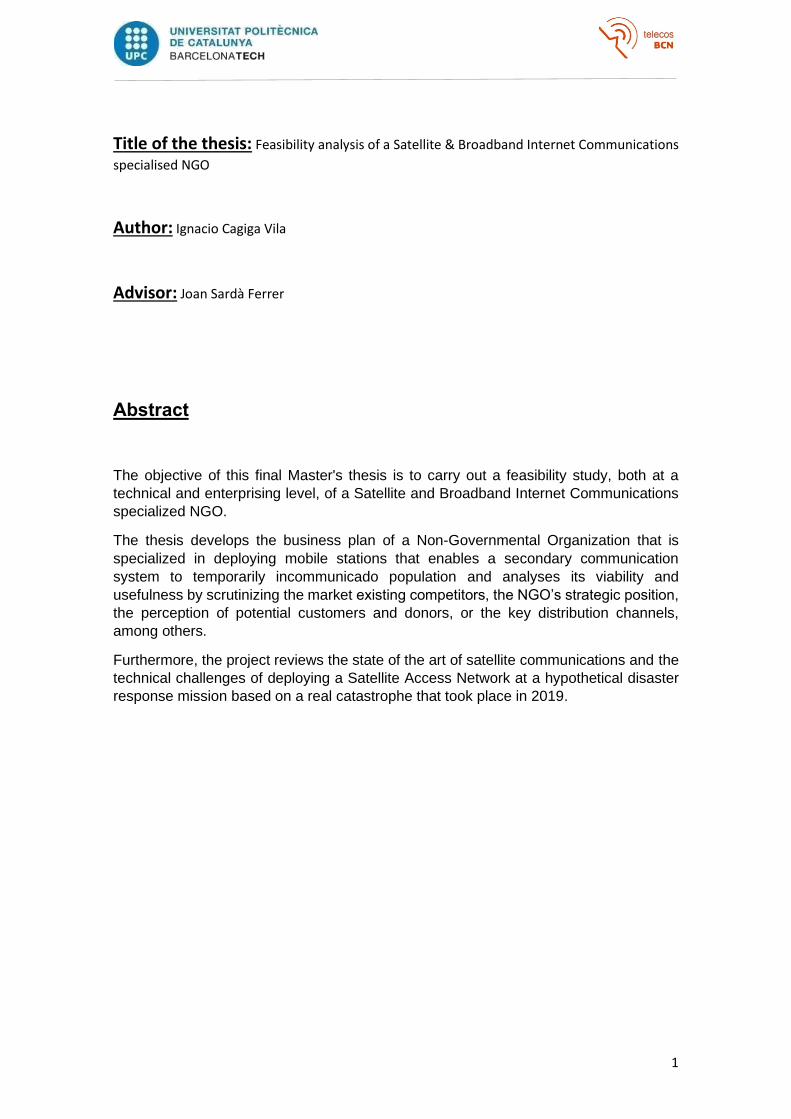
Title of the thesis: Feasibility analysis of a Satellite & Broadband Internet Communications
specialised NGO
Author: Ignacio Cagiga Vila
Advisor: Joan Sardà Ferrer
Abstract
The objective of this final Master's thesis is to carry out a feasibility study, both at a
technical and enterprising level, of a Satellite and Broadband Internet Communications
specialized NGO.
The thesis develops the business plan of a Non-Governmental Organization that is
specialized in deploying mobile stations that enables a secondary communication
system to temporarily incommunicado population and analyses its viability and
usefulness by scrutinizing the market existing competitors, the NGO’s strategic position,
the perception of potential customers and donors, or the key distribution channels,
among others.
Furthermore, the project reviews the state of the art of satellite communications and the
technical challenges of deploying a Satellite Access Network at a hypothetical disaster
response mission based on a real catastrophe that took place in 2019.

2
Acknowledgments
I would like to thank all the friends I have met at the UPC since I moved into Barcelona and
above all, Joan, who has been really encouraging and instructive during this long thesis that
outlived a global pandemic. Thanks to my family, Planeta 13, and Lamli’s Army.
3
Revision history and approval record
Revision Date Purpose
1.0 03/03/2020 Document creation
1.1 19/04/2020 Document revision
1.2 28/06/2020 Document revision
1.3 04/11/2020 Document revision
1.4 17/11/2020 Document revision
1.5 02/12/2020 Document revision
1.6 07/01/202 Document revision
1.7 12/01/2021 Document revision
1.8 18/01/2021 Document revision
1.9 22/01/2021 Document revision
2.0 25/01/2021 Document revision
2.1 27/01/2021 Document revision
2.2 28/01/2021 Document revision
2.3 29/01/2021 Document revision
Written by: Reviewed and approved by:
Date 29/01/2021 Date 30/01/2021
Name Ignacio Cagiga Vila Name Joan Sardà Ferrer
Position Project Author Position Project Supervisor
4
Table of contents
Abstract ......................................................................................................................................... 1
Acknowledgments ......................................................................................................................... 2
Revision history and approval record ........................................................................................... 3
Table of contents ........................................................................................................................... 4
List of Tables .................................................................................................................................. 5
List of Figures ................................................................................................................................ 6
1. Introduction ...................................................................................................................... 7
1.1. Objectives .................................................................................................................... 7
2. State of the art ................................................................................................................. 8
3. Business model ............................................................................................................. 12
3.1. Business model Canvas .......................................................................................... 12
3.2. Business idea development .................................................................................... 17
3.2.1. Positioning ................................................................................................................. 18
3.2.2. SWOT ......................................................................................................................... 20
3.2.3. Porter’s Five Forces ................................................................................................. 22
3.2.4. The Traction Bullseye Framework ......................................................................... 26
4. Practical Development ................................................................................................. 29
4.1. Scenario ..................................................................................................................... 29
4.2. Mission needs and requirements ........................................................................... 30
4.3. Commercial solutions and supplier’s analysis ..................................................... 31
4.4. Deployment and data measurement ..................................................................... 34
4.5. Costs ........................................................................................................................... 38
5. Conclusions ................................................................................................................... 40
A. Appendixes .................................................................................................................... 41
A.1 Environment Analysis .............................................................................................. 41
A.1.1 Economic analysis ............................................................................................... 41
A.1.2 Juridical-Legal analysis ....................................................................................... 47
A.1.3 Technological Analysis ....................................................................................... 49
Bibliography ................................................................................................................................ 53
5
List of Tables
Table 1: BGAN Terminal Comparison chart [50] ......................................................................... 33
Table 2: Quarterly variation of the Gross Domestic Product (GDP) at market prices in Spain.
Source: Spanish National Institute of Statistics (INE) .................................................................. 42
Table 3: Annual variation of the Gross Domestic Product (GDP) at market prices in Spain.
Source: Spanish National Institute of Statistics (INE) .................................................................. 43
Table 4: Evolution of debt from July 2019 to July 2020 in Spain. Source: Expansión newspaper,
https://datosmacro.expansion.com/ .......................................................................................... 44
Table 5: Public Debt comparison in Europe as of December 2019. Source: Expansión
newspaper, https://datosmacro.expansion.com/ ...................................................................... 45
Table 6: Public deficit comparison by country as of December 2019. Source: Expansión
newspaper, https://datosmacro.expansion.com/v .................................................................... 46
Table 7: The unemployment rate in Spain. An evolution from 2017 to 2020. Source: National
Institute of Statistics.................................................................................................................... 46
Table 8: The unemployment rate in July 2020 in different countries of the Euro Zone. Source:
Expansión newspaper, https://datosmacro.expansion.com ...................................................... 47
6
List of Figures
Figure 1: Satellite communications: A brief history from Sputnik to ViaSat-3 [19] ...................... 9
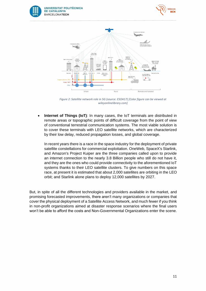
Figure 2: Satellite network role in 5G (source: ESOA17) [Color figure can be viewed at
wileyonlinelibrary.com]............................................................................................................... 11
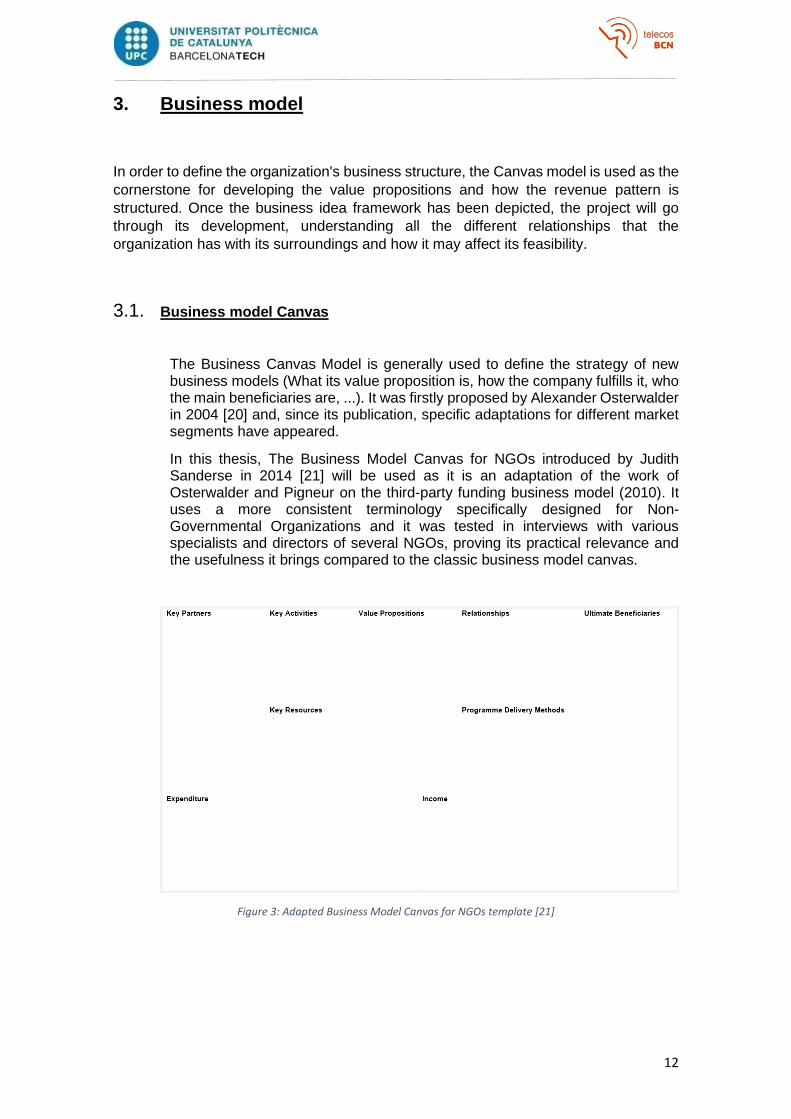
Figure 3: Adapted Business Model Canvas for NGOs template [21] ........................................... 12
Figure 4: Adapted Business Model Canvas for a Satellite & Broadband Internet
Communications specialized NGO. Source: own compilation .................................................... 17
Figure 5: Cost-Ethical Standards conceptual map Source: own compilation ............................. 20
Figure 46: A SWOT analysis, with its four elements in a 2×2 matrix.[37] ................................... 21
Figure 57: Graphical representation of Porter's Five Forces framework [31] ............................ 23
Figure 68: Traction channels proposed by Gabriel Weinberg and Justin Mares. Source: own
compilation ................................................................................................................................. 26
Figure 79: Organization's Traction Bullseye Framework. Source: own compilation .................. 27
Figure 10: Location of Beira in Mozambique. Source: Wikipedia ............................................... 31
Figure 11: The BGAN coverage map. Source: groundcontrol.com ............................................. 32
Figure 12: Humanitarian operations map. Source: Own compilation ........................................ 35
Figure 15: Quarterly variation of the Gross Domestic Product (GDP) at market prices in Spain.
Source: Spanish National Institute of Statistics (INE) .................................................................. 43
Figure 16: Annual variation of the Gross Domestic Product (GDP) at market prices in Spain.
Source: Spanish National Institute of Statistics (INE) .................................................................. 44
Figure 17: Public deficit comparison by country as of December 2019. Source: Expansión
newspaper, https://datosmacro.expansion.com/ ...................................................................... 45
Figure 18: Basic Satellite Communication System Architecture Fuente: Chapter 5 - Satellite
Telecommunication Systems, Telecommunication Systems (TSYS) subject, MET, UPC ............. 51
7
1. Introduction
In August 2005, a Category 5 Atlantic hurricane known as Katrina emerged into the Gulf
of Mexico causing 1.800 deaths and $125 billion in damage, particularly in the city of
New Orleans, USA [1][2]. Three years later, in Sichuan, China, an 8.0 earthquake and
several 6.0 aftershocks left over 69.000 dead people, more than 374.000 injured and
more than 18.000 people reported as missing [3][4]. Years later, in January 2010, just
12 days into the new year, a massive 7.0 earthquake struck Port-au-Prince, Haiti the
poorest country in the Western Hemisphere, leaving roughly 250.000 lost lives and about
1.5M people forced to live in makeshift internally displaced person camps [5][6][7]. One
year later, the great east Japan earthquake in 2011 named Tohoku caused a
catastrophic tsunami leaving more than 450.000 homeless people and over 15.500 lost
lives [8][9][10].
But during this century, not only natural disasters have affected the human population's
lives, homes, and freedoms. Unfortunately, we’ve grown used to seeing how political, or
economical disagreements led to armed conflicts forcing people out of their homes and
cities. Thousands of migrants from Honduras, Guatemala, Nicaragua, El Salvador, and
Mexico seeking US asylum as extreme poverty and ultraviolence reigned in Central
American countries [11][12][13]; or the more than 13M Syrian citizens that fled their
country throughout the Syrian Civil War [14][15], are some of the many examples.
The liaison among all those humanitarian crises, both natural or political, is that
conventional communication infrastructures such as terrestrial or mobile networks may
be partially or even completely unavailable and the affected population may be suffering
from isolation and will require an alternative telecommunication system. In these
situations, there are alternative technologies for restoring reliable communication links,
but there aren’t many NGOs covering these needs, and most of the time the national
army or any other governmental force would try to cope with that as well as it might.
This master thesis proposes an NGO that systematically deploys to humanitarian crises,
caused by natural disasters or armed/political conflicts, with a fleet of several satellite
terminals and satellite phones to provide its expertise and support to the affected
population or the humanitarian coordination facilitating the exchange of information and
improving the effectiveness of the general response.
1.1. Objectives
The objective of this final Master's thesis is to carry out a feasibility study of a Non-
Governmental Organization that is specialized in deploying mobile stations that enables
a satellite communication system to temporarily incommunicado population.
Considering the disruptiveness and newness of the services offered, the proposed
business model entails several technical and enterprising challenges that include
providing an effective humanitarian response, identifying and managing humanitarian
missions, support disaster response coordination, defining the most suitable strategy for
the organization’s characteristics and the markets in order to impact as many people as
possible and in the best possible way, defining the NGOs strategic position within the
market, or achieving cost-effectiveness, among others.
8
2. State of the art
According to the Directive 2002/21/EC of the European Parliament and of the Council of 7 March 2002, a Telecommunications system encompasses the transmission equipment, switching or routing equipment, and other resources that permit the conveyance of signals by wire, by radio, by optical or by other electromagnetic means, irrespective of the type of information conveyed [16]. Both terrestrial and mobile networks are strongly rooted in our daily lives as people grow more dependent on the Internet and on being perpetually “online”. But what would happen if they suddenly get partially or even destroyed? In this case, there are alternative technologies for restoring reliable communication links, such as a global network of communication satellites covering a large part of the earth's surface that offers an alternative way for compact terminals to communicate or to have Internet connectivity in almost any possible situation and for several hours.
Many progresses have occurred in satellite communications systems until this day since the first artificial satellite (Sputnik-1) dedicated to sending atmospheric and climatic data broadcasting in the 20 and 40 MHz bands, was put into orbit in 1957 [17][18][19]. Passing through the first satellites that supported bidirectional voice circuits in the middle of the decade of the 60, or the first satellite system LEO (Low Earth Orbit) of telephone communications at the end of the 90 [17].
The first operational satellites whose main function was the provision of communications systems for military, governmental, or scientific purposes were adapted to exploit the trading potential of this technology. Thus, in 1964 the INTELSAT (International Telecommunications Satellite Organization) consortium was formed, which would be responsible for launching the first satellites (Intelsat I, II, and III) capable of offering more than 240 voice circuits or a bidirectional television channel for commercial purposes [17].
9
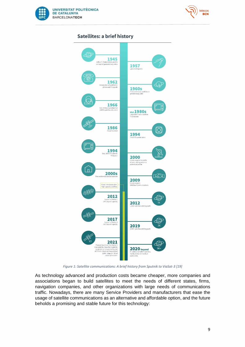
Figure 1: Satellite communications: A brief history from Sputnik to ViaSat-3 [19]
As technology advanced and production costs became cheaper, more companies and
associations began to build satellites to meet the needs of different states, firms,
navigation companies, and other organizations with large needs of communications
traffic. Nowadays, there are many Service Providers and manufacturers that ease the
usage of satellite communications as an alternative and affordable option, and the future
beholds a promising and stable future for this technology:
10
• Costs reducing: SpaceX has begun to use a reusable launch system or
reusable launch vehicle (RLV), which allows recovering the propellants used to
put capsules or satellites into orbit.
At the beginning of 2019, the Iridium NEXT constellation, developed and built
by Thales Alenia Space leading an industrial consortium, managed to complete
its network of 75 operational satellites orbiting in LEO thanks, in part, to the
participation of SpaceX in the final phase of the deployment of the network with
your Falcon-9 block 5 vehicles.
In addition to the Falcon 9, the Electron from Rocket Lab, and the Miura 5 from
PLD Space, they are launch systems that reduce the cost of a launch between
10 and 100 times.
• Sat5G: The fifth generation of mobile telephony is currently in an initial
deployment phase, but exponential growth is expected between 2020 and 2030.
Several projects and whitepapers (SPECSI, MENDHOSA, and INSTINCT,
CloudSat, SANSA, VITAL, RIFE, and SCORSESE) have already studied the
role that satellite communications can play as an integral part of the 5G
ecosystem so as to achieve Key Performance Indicators ( KPIs) minimum
established for adequate service.
The ubiquity of satellite systems, their mobility, the capacity for broadcast
transmission, or the reliability and resilience of the network, are characteristics
that make a mixed Sat5G scenario possible where business opportunities can
be grouped into two categories:
▪ Offloading and caching in the fixed network: provision of alternative or
overlay paths for (a) connecting data centers to 5G core network
gateways where there are no terrestrial or economically viable paths and
(b) connecting the core network to semi-centralized or centralized
virtualized eNodeB processing centers.
▪ Backhaul: Provision of alternative or overlay paths for backhaul
connections to 5G cells in all layers (macro, micro, etc.). Opportunities
are (a) backhaul to cells in remote areas that are installed to achieve a
certain coverage obligation, for example, to satisfy license or contractual
requirements, and where a terrestrial link is not economically viable, (b)
cells that need fast deployment and cannot wait for terrestrial
provisioning, (c) deployment of cells for temporary events, and (d)
deployment of small mobile cells mounted on public transport, on high‐end cars, or emergency service vehicles.
11
Figure 2: Satellite network role in 5G (source: ESOA17) [Color figure can be viewed at wileyonlinelibrary.com]
• Internet of Things (IoT): In many cases, the IoT terminals are distributed in
remote areas or topographic points of difficult coverage from the point of view
of conventional terrestrial communication systems. The most viable solution is
to cover these terminals with LEO satellite networks, which are characterized
by their low delay, reduced propagation losses, and global coverage.
In recent years there is a race in the space industry for the deployment of private
satellite constellations for commercial exploitation. OneWeb, SpaceX's Starlink,
and Amazon's Project Kuiper are the three companies called upon to provide
an internet connection to the nearly 3.8 Billion people who still do not have it,
and they are the ones who could provide connectivity to the aforementioned IoT
systems thanks to their LEO satellite clusters. To give numbers on this space
race, at present it is estimated that about 2,000 satellites are orbiting in the LEO
orbit; and Starlink alone plans to deploy 12,000 satellites by 2027.
But, in spite of all the different technologies and providers available in the market, and
promising forecasted improvements, there aren’t many organizations or companies that
cover the physical deployment of a Satellite Access Network, and much fewer if you think
in non-profit organizations aimed at disaster response scenarios where the final users
won’t be able to afford the costs and Non-Governmental Organizations enter the scene.
12
3. Business model
In order to define the organization's business structure, the Canvas model is used as the
cornerstone for developing the value propositions and how the revenue pattern is
structured. Once the business idea framework has been depicted, the project will go
through its development, understanding all the different relationships that the
organization has with its surroundings and how it may affect its feasibility.
3.1. Business model Canvas
The Business Canvas Model is generally used to define the strategy of new business models (What its value proposition is, how the company fulfills it, who the main beneficiaries are, ...). It was firstly proposed by Alexander Osterwalder in 2004 [20] and, since its publication, specific adaptations for different market segments have appeared.
In this thesis, The Business Model Canvas for NGOs introduced by Judith Sanderse in 2014 [21] will be used as it is an adaptation of the work of Osterwalder and Pigneur on the third-party funding business model (2010). It uses a more consistent terminology specifically designed for Non-Governmental Organizations and it was tested in interviews with various specialists and directors of several NGOs, proving its practical relevance and the usefulness it brings compared to the classic business model canvas.
Figure 3: Adapted Business Model Canvas for NGOs template [21]
13
• Value propositions
During the last decades, the number of natural disasters and political conflicts
have increased as well as its impact has on the human beings that suffered from
isolation, famine, poverty, or homelessness among others because of those
kinds of situations. The organization is specialized in enabling satellite
communications systems for temporarily incommunicado populations by
deploying mobile stations equipped with a Satellite Access Network that offers
the affected users a possibility to make a phone call to their relatives or to
contact and locate other people who may have been cut off due to the same
situation they are experiencing. The affected population can also make use of
several deployed computers with Internet access so that they can e-mail their
relatives, check the news and the external opinion, or receive advice and official
communications aimed at solving their primary needs in a particular situation.
In the same way, these deployed mobile stations can help humanitarian
coordination by offering other non-profit non-governmental organizations with a
communications system during their own missions. The organization’s
telecommunications tents can be also helpful to quantify the number of affected
users and it can serve as a tool to locate and unite them with their relatives.
By extension, the NGO’s proposition secures the availability of conventional
communication systems in a reliable way for all the people under private or
public bodies’ responsibility scope.
Lastly, the organization aims to serve as a referent for IT-related students,
professionals, and concerned people for volunteering or to collaborate as a
donor with its disruptive technology solutions that allow a more effective and
tailored emergency response in order to reduce the impact on the affected
populations.
Both the advantages of satellite communication systems over conventional
terrestrial systems (radio, 3G, 4G, 5G, …) listed in Appendix A.1.3, and the
forecasted industry improvements depicted in chapter 2, grants the satellite
industry a promising development in the years to come.
• Ultimate beneficiaries
The target group who the organization principally aims to reach and serve to
achieve its vision/mission on a B2C (Business to Customers) basis amasses all
kind of people that lack access to conventional communication systems such
as the phone network, GSM, 3G, 4G, …They may be suffering from temporary
isolation due to a natural disaster or any other type of external agent (civil wars,
migration, etc.) and the NGO can facilitate an alternative solution based on its
disruptive offering. Within this group of end-beneficiaries, there are other NGOs
and humanitarian coordination bodies that require B2B (Business to Business)
services comprising a satellite link deployment (bandwidth, satellite phones,
PCs, BBDDs, etc.), IT support, or specific data reports (volume of aided people,
reported as missing, lost lives, …) during the deployment of a specific project.
By extension, the organization is serving the private and public bodies (such as
national governments) under whose responsibility lies the well-being of its
population, by offering them an alternative telecommunication network.
14
Lastly, during its mission’s deployment, the organization would be also assisting
all the relatives and close friends of the people that resulted temporarily affected
and who wish to contact them or find out about their situation.
On second thoughts, the NGO can be reaching people who sympathize with the
organization’s values and who might not be directly related with the missions’
root causes, but who are willing to collaborate by volunteering or by becoming
donors.
• Relationships
With the main beneficiaries (the people affected, their close relatives, and their
close friends) the NGO maintains a personal relationship, by traveling to the
affected region with qualified personnel and accompanying the affected ones in
the delicate situation they are in (installing all the equipment, teaching them how
to use it, etc.).
Subsequently, the NGO maintains a transparent and collaborative relationship
with the public and private organizations that finance and enable each of the
projects, through aggregated data, executive reports of the service, or more
agile coordination sessions with the authorities or any other deployed NGOs.
Finally, agreements must be created with other NGOs to create long-term
patronage/sponsorship contracts, which facilitate the identification of potential
needs, the coordination of joint projects, the continuous improvement of the
service provided, and helps to gain popularity. An essential point for achieving
the organization’s success and feasibility lies in how to focus on the right
channels for distribution resulting in a surge of customer/donor acquisition. In
chapter 3.2.4, the Bullseye Framework depicts why creating these long-term
partnerships with other NGOs represents the ideal traction channel for the NGO.
• Program Delivery Methods
With both the affected users and all the other NGOs and humanitarian response
bodies served during a specific deployment, the organization maintains a direct
interaction and onsite/online meetings in order to adapt and correct any possible
aspect non-compliant with the agreed SLAs (proposals, initial scope,
methodology, the temporary planning of the service, the estimated costs,
forecasting, metrics, monitoring, QoS, bottlenecks, etc.).
Besides that, the NGO creates strategic partnerships with a range of
international and local organizations and periodical committees need to be held
to revise the correct operation methods and potential improvement points of the
joint ventures.
As explained in chapter 3.2.4, part of the organization achieving its mission and
delivering its value propositions lays in choosing adequate traction channels,
resulting in a surge of customer/donor acquisition. Apart from creating strategic
partnerships with other NGOs (what the Bullseye Framework calls as Business
Development), Speaking Engagements and Targeting Blogs are the two other
chosen channels because they are frequented by most of the target audience

15
and that is where the NGO can engage them the most (Forums, Congresses,
Conferences, Blogs, Reddit, etc.).
• Key Activities
The key actions that the organization needs to perform to create its value
propositions and satisfy the basic needs of its ultimate beneficiaries by
deploying a complete mission starts at being able to identify the people's needs.
The organization firstly needs to have the means of identifying potential needs
and catastrophically situations to travel to. As the NGO lacks the means to do it
by itself and it is not a part of its value proposition, strategic partnerships with
more mature organizations that have a wider operating area can be the key to
easily identify potential needs and coordinate joint humanitarian responses.
After having the ability for identifying potential needs, the organization needs to
estimate the mission’s characteristics and requirements so that they can
dimension the satellite link and deploy the potentially required resources. Along
with this pre-study, the organization will analyze all the commercial solutions
and manufacturers that best fit each mission in terms of cost reduction, ease of
transportation, or inter interoperability. Managing the key resources to
adequately dispose of a project is one of the most important actions to be
covered. Although the rationale behind each project may differ, they all require
almost the same type of devices to deploy the satellite access network
(bandwidth, terrestrial antennas, switches, computers, satellite phones, routers,
…) so buying in bulk or establishing long time agreements with several
manufacturers and service providers in order to reduce the NGOs expenditures
incurred in when deploying a mission.
Lastly, the key activity to be fulfilled during every mission recalls data
measurement and reporting for other NGOs, or the responsible public and
private bodies to assist the humanitarian coordination.
• Key Resources
Concerning the key activities followed to deploy a mission, the organization
needs specific physical, financial, intellectual, or human assets to make the
business model work.
Physical Resources, such as the equipment that the organization must have to
deliver its value proposition, and which the ultimate beneficiaries will make use
of (VSAT/BGAN antennas, satellite phones, laptops, routers, tents, electric
generators, tables, etc. chairs, tents, etc.); as well as human resources, such
as technical personnel specialized in the deployment and handling of satellite
terminals and hubs (Engineering, Information Technology, Computer Science,
… Bachelor degrees or HNC) or volunteers that may result as a profitable
temporal workforce to facilitate the NGO’s value proposition.
Please see Appendix A.1.3 for more details on the satellite communications
network segments and their key components.
16
• Key Partners
Among the described key activities, some of them cannot be carried out by the
organization itself and that require partnerships and patronage contracts to be
established.
The organization will mainly establish business alliances with any other Non-
Governmental Organizations (e.g. Télécoms Sans Frontières, Open Arms,
A4AI,…) to facilitate the identification of new project opportunities, help lowering
costs of service deployment (and therefore the profit margin), and allow finding
points of improvement in the service provisioning. In chapter 3.2.4, the Bullseye
Framework depicts why creating these long-term partnerships with other NGOs
represents the ideal traction channel for the NGO.
Additionally, the organization will establish strategic alliances with Satellite
Network Operators (e.g. Hispasat, SES, Intelsat, Inmarsat, …), Network
Providers, and manufacturers (e.g. ViaSat, Hughes, iDirect, …) that helps the
organization on reducing the spent on OPEX and CAPEX expenses for each
project, such as the bandwidth required for each deployment, or the antennas,
terminals and other necessary equipment. This kind of alliance may result in a
positive impact for those private companies too as they can show off being
concerned with its social impact and collaborating with an innovative socially-
oriented startup organization.
Please see Appendix A.1.3 for more details on the agents involved in the
provision of a satellite communications service.
• Expenditure
The main expenditure spotlights the managing of all the key resources and
equipment needed to deploy the satellite communications access network. This
amasses practically each of the organization’s key activities.
Along with the equipment managing, outsourcing the satellite bandwidth is the
second expenditure in magnitude in the importance scale.
Lastly, the NGO also faces the employees’ salaries (the organization’s second
key resource) and the collateral expenses derived from the mission’s
deployment.
• Income
Analyzing the economic income streams that feed the organization’s cash flow
and that it has available for working on its value proposition and addressing the
needs of the affected one we can differentiate two entities:
The first one, which can represent up to 60% of the organization's funding
streams, is the public segment. It is made up of grants from local, regional, state,
or international administrations.
On the other hand, the private segment includes both donations from
companies and entities aware of their social impact, as well as donations from
individuals or Other People’s Money (OPM) who can freely choose the
17
frequency and amount of money they wish to donate, Venture Capitals, etc.
Other examples of private financing channels can be crowdfunding,
growfunding, collaborations with brands that help lower the cost of the services
provided, patronage, selling merchandising, renting / leasing of terminals or the
bandwidth contracted to other organizations, etc. As stated in the appendix
A.1.1, it is vital to ensure that private funds do not represent a critical share of
the organization’s sources of income so that the organization can continue
operating without being affected by fluctuations in the macroeconomic
indicators.
Finally, within the non-monetary income streams, the organization
contemplates volunteering as an essential stimulus to carry out many vital tasks
and activities that facilitate the development of the NGO’s value proposition. In
this regard, volunteers are seen as one of the organization’s key resources.
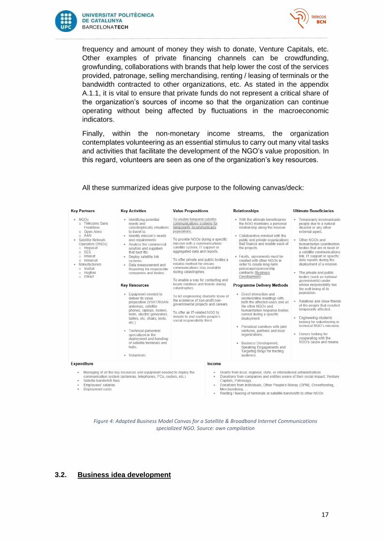
All these summarized ideas give purpose to the following canvas/deck:
Figure 4: Adapted Business Model Canvas for a Satellite & Broadband Internet Communications specialized NGO. Source: own compilation
3.2. Business idea development
18
The organization’s business idea consists of offering a satellite coverage service to
private and public organizations or bodies suffering from catastrophic situations where
the people under their own direct responsibility may be lacking the means to make a
phone call or accessing the Internet (temporary uncommunication).
The organization fulfills this business idea by deploying mobile stations or tents acting
as the satellite network access segment that will provide the affected users with several
stations equipped to enable them to make a phone call to their relatives or to contact and
locate other people who may have been cut off due to their same situation. The final
users can also make use of several computers with Internet access so that they can e-
mail their relatives, check the news and the external opinion, or receive advice and
official communications aimed at the particular situation.
In this section, the business idea will be developed and tested with the help of different
tools such as Porter's five forces model or the 4 actions framework. Besides that, an in-
depth analysis of the positioning and targeting that the business idea must follow is
conducted in the following bullets.
3.2.1. Positioning
Positioning refers to the place that a company occupies in the minds of
customers concerning the competitors. To identify suitable positions that a
company or brand might occupy in a given market, analysts often turn to
techniques such as perceptual mapping or correspondence analysis. [22]
• Differentiation
Offering service differentiation leads to competitive advantage and consists
of identifying a set of possible internal advantages to build a position on by
providing a superior value proposition.
The organization offering differentiation lays in its social value, impartiality,
and non-profit premise. Those key aspects are discernible in the service
offering price values and they may differentiate the NGO from other
competitors when a private or public body (such as national governments)
needs an alternative communications network to give back to the people
under their responsibility the ability to communicate in times of need.
• Market rivalry
In order to be able to analyze the actual sector rivalry situation among other
organizations and competitors, a small study has been carried out among
a total of four companies/bodies that can be placed as a direct competition
to the service the NGO proposes, these five entities/bodies are Armed
Forces, Open Arms, Red Cross, Inmarsat, and Télécoms Sans Frontières.
The solution provided by each of these entities will be analyzed and
compared with the service offered by this thesis’ organization to be able to
resolve the competitive positioning analysis along with a perceptual
mapping representation:
19
o Armed Forces [23]: Given that this pattern can be extrapolated to any
other country that hosts a redundant satellite network for surveillance,
communications, or military purposes among others, this study is focused
on the Spanish Armed Forces’ satellite capabilities. Since more than a
decade ago, the Spanish Armed Forces maintains an operative use of its
own satellite communication model known as SPAINSAT and it leads the
GOVSATCOM European initiative in the EDA field. This body possesses
all the essential resources, technology, and knowledge needed to offer a
similar service as the organization does, but the expenses of the satellite
core network deployment, its maintenance, the army’s limited operating
area, and its military-oriented mindset withdraw it from the rivalry map.
o Open Arms [24]: This Spanish NGO is devoted to protecting those who
try to reach Europe by sea, fleeing from armed conflict, persecution, or
poverty. This thesis organization purpose and Open Arms’ may collide or
concur in some aspects. Although both non-profit non-governmental
organizations start a similar economical structure, Open Arms lack the
knowledge and expertise on installing and operating satellite
telecommunications networks (they have already collaborated in several
missions with other NGOs and entities with a stronger IT background
[25]), which harms its positioning on the perceptual map.
o Red Cross [26][27]: This centenary international humanitarian movement
possesses the necessary workforce, means, longevity, and solvency to
become a tough rival. Its de-centralization into three different entities and
its shortfall of experience in disaster response missions requiring a
stronger IT skillset may slightly harm its location on the perceptual map.
Nonetheless, its presence in more than 190 countries and its expertise in
disaster response and humanitarian help missions places Red Cross
close to the origin of the coordinate system.
o Inmarsat [28]: As the leader satellite Service Provider (SP), Inmarsat
possesses all the required resources, maturity, and solvency to burst into
the market and becoming a serious threat at almost zero cost. However,
its enrichment intentions displace Inmarsat from the non-profit market
rivalry layout and belittle it as an actual competitor.
o Télécoms Sans Frontières [29]: Founded around twenty years ago, this
organization is specialized in emergency-response technologies and has
evolved into the IT-related NGO model thanks to its more than 140
humanitarian missions. It is stated as the “big rival” but its maturity and
background in the sector can also be taken as an advantage for this thesis
organization as the ideal partnership to be held. Besides that, the size
difference among both NGOs can imply important ease for cost-cutting
and rivalry narrowing.
• Perceptual mapping
20
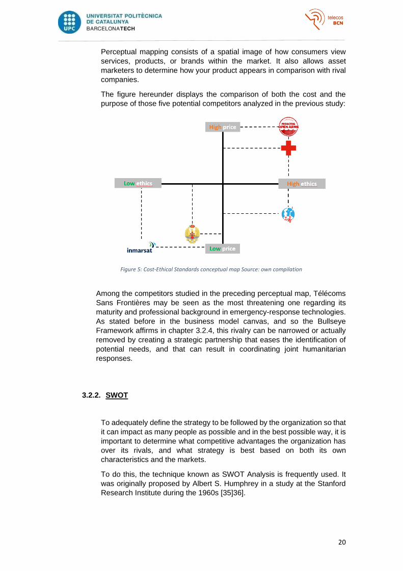
Perceptual mapping consists of a spatial image of how consumers view
services, products, or brands within the market. It also allows asset
marketers to determine how your product appears in comparison with rival
companies.
The figure hereunder displays the comparison of both the cost and the
purpose of those five potential competitors analyzed in the previous study:
Figure 5: Cost-Ethical Standards conceptual map Source: own compilation
Among the competitors studied in the preceding perceptual map, Télécoms
Sans Frontières may be seen as the most threatening one regarding its maturity and professional background in emergency-response technologies.
As stated before in the business model canvas, and so the Bullseye
Framework affirms in chapter 3.2.4, this rivalry can be narrowed or actually
removed by creating a strategic partnership that eases the identification of
potential needs, and that can result in coordinating joint humanitarian
responses.
3.2.2. SWOT
To adequately define the strategy to be followed by the organization so that
it can impact as many people as possible and in the best possible way, it is
important to determine what competitive advantages the organization has
over its rivals, and what strategy is best based on both its own
characteristics and the markets.
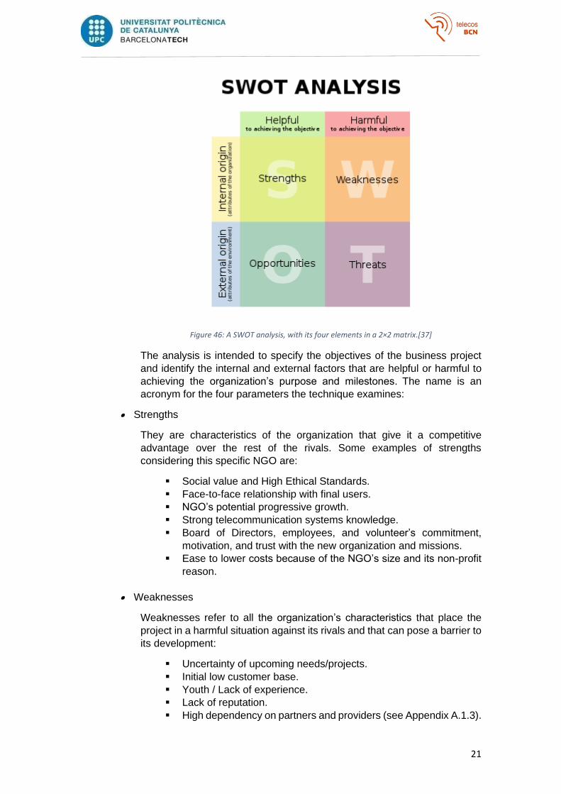
To do this, the technique known as SWOT Analysis is frequently used. It
was originally proposed by Albert S. Humphrey in a study at the Stanford
Research Institute during the 1960s [35]36].
21
Figure 46: A SWOT analysis, with its four elements in a 2×2 matrix.[37]
The analysis is intended to specify the objectives of the business project
and identify the internal and external factors that are helpful or harmful to
achieving the organization’s purpose and milestones. The name is an
acronym for the four parameters the technique examines:
• Strengths
They are characteristics of the organization that give it a competitive
advantage over the rest of the rivals. Some examples of strengths
considering this specific NGO are:
▪ Social value and High Ethical Standards.
▪ Face-to-face relationship with final users.
▪ NGO’s potential progressive growth.
▪ Strong telecommunication systems knowledge.
▪ Board of Directors, employees, and volunteer’s commitment,
motivation, and trust with the new organization and missions.
▪ Ease to lower costs because of the NGO’s size and its non-profit
reason.
• Weaknesses
Weaknesses refer to all the organization’s characteristics that place the
project in a harmful situation against its rivals and that can pose a barrier to
its development:
▪ Uncertainty of upcoming needs/projects.
▪ Initial low customer base.
▪ Youth / Lack of experience.
▪ Lack of reputation.
▪ High dependency on partners and providers (see Appendix A.1.3).
22
• Opportunities
Beneficial situations or elements in the environment that can be exploited
to the organization’s advantage:
▪ Strategic Partnerships with other non-governmental
organizations.
▪ Possibility of deploying longer missions whose root causes may
differ from temporary catastrophic situations (E.g. remote
incommunicado villages, islands, etc.).
▪ Lack of competitors in Spanish-speaking countries.
▪ Increasing needs from final users (more armed conflicts, more
natural disasters, …).
▪ Cost reducing opportunities in the satellite industry (see chapter
2).
• Threats
They are detrimental or negative situations or factors in the environment
that could endanger or cause a problem to the organization. It is advisable
to consider strategies to reduce the impact of the following threats
▪ General mistrust on NGOs (lack of donors).
▪ Bigger and more mature NGOs may copy the business model and
become a competitor facing few troubles.
▪ New disruptive technologies and substitute services.
▪ Economic situation (see Appendix A.1.1).
3.2.3. Porter’s Five Forces
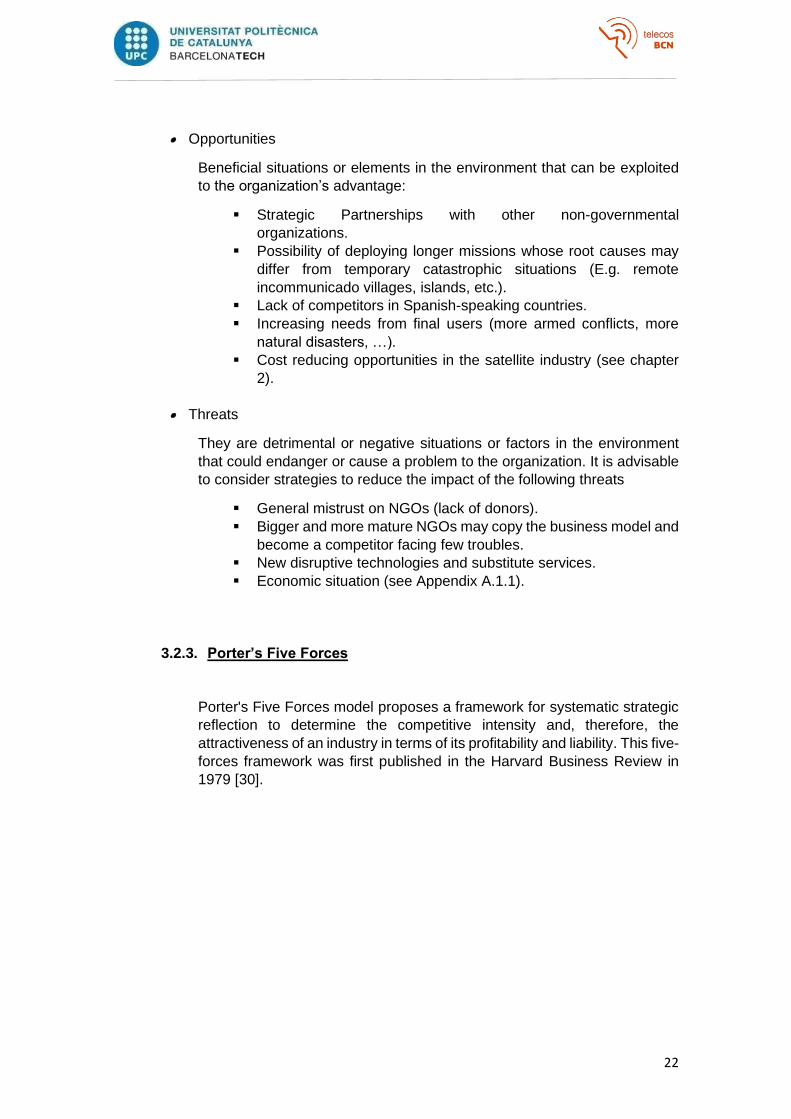
Porter's Five Forces model proposes a framework for systematic strategic
reflection to determine the competitive intensity and, therefore, the
attractiveness of an industry in terms of its profitability and liability. This five-
forces framework was first published in the Harvard Business Review in
1979 [30].
23
Figure 57: Graphical representation of Porter's Five Forces framework [31]
The analysis focuses on the organization’s microenvironment to study the
existing rivalry in the sector by analyzing those five forces close to a
company that may affect its ability to serve its customers and make a profit:
• Bargain power of buyers/beneficiaries
The bargaining power of beneficiaries refers to the pressure that the public
or private organizations to which the service is provided can exert, to obtain
higher quality service, at a lower cost or for a longer time.
Starting from the affected users, as the organization’s main ultimate
beneficiaries, their bargain power is actually null because they are mere
receivers of the provided service and cannot interfere with the agreed SLAs
and costs.
On the other hand, the bargaining power of all the non-governmental
organizations, companies, and public bodies purchasing the NGO’s
services supposes a high bargain power even though it cannot be
considered as a high criticality risk. The scarcity of competitors and the
differential advantage that the organization has over other potential
companies that can provide the same service even at a lower cost, (thinking
about its social purpose and higher ethical standards) leave this group of
beneficiaries with a limited bargain power.
• Bargain power of suppliers
This force analyzes the reliance that the organization has on its main
suppliers that provide it with its key Resources or that the organization
depends on to develop its key activities such as Satellite Network

24
Operators, Service Providers, or manufacturers. Appendix A.1.3 lists more
details on the agents involved in the provision of a satellite communications
service.
In this case, the bargaining power of the suppliers is considered critical
because the main activity of the organization has a strong reliance on the
outsourcing of satellite bandwidth and the acquisition of all the necessary
equipment, being both key resources that the NGO cannot develop or
produce by itself.
This force aggravates when considering the shortage of providers
specialized in satellite communications and their decision-making power
over the final price of the items or services contracted.
For example, if Inmarsat were to increase the price of the antennas and
terminals needed during an emergency response deployment, it will
translate into a more expensive and therefore a less competitive and
profitable service.
With all that being said, from the point of view of the organization’s
suppliers, the NGO is just one contractor among the hundreds of thousands
they have, and considering that the suppliers may raise the agreed costs is
just a naïve thought.
• Threat of new entrants
This third force analyzes the ease that potential competitors have for
entering the business and therefore becoming a threat to the organization.
The entry of new competitors poses a low criticality risk for the NGO since
a wide variety of companies and organizations may be able to offer a similar
service facing lesser obstacles, but their ethical standards and the fact that
the potential profits may only cover the incurred costs, withdraw them from
the rivalry map scenario. Among the potential competitors are:
▪ The public or private organizations that decide to offer the service
themselves given the individuals’ needs under their area of
responsibility, for example, through the local military body. In
these situations, the new entrants may possess the necessary
resources, but they are lacking the social values that recognize
them as actual competitors.
▪ Companies already established in the sector, such as Mobiles
Service Providers, whose initial investment can be expected to be
much smaller in order to start offering the same services as this
organization. In the same way, this kind of companies’ absence of
social values and humanitarian-oriented purposes belittles them
as actual competitors.
▪ More mature non-governmental organizations that decide to start
covering these types of needs and may be considered the most
serious competitors. The fact that the potential profits may only
cover the incurred costs could make them decide to subcontract
the service to specialized companies or organizations such as this
thesis’.
25
In order to nullify the already low impact that new entrants have on the
future of the organization, measures must be taken that favor
differentiation, which can increase customer and investor loyalty. Being a
non-profit organization already differentiates this NGO from the first and
second group of potential competitors on account of the social value it is
adding to the initial service offering.
As mentioned in previous chapters (model canvas’ key partners, market
rivalry, SWOT’s Opportunities, …), the organization definitely needs to
establish business alliances with other Non-Governmental Organizations
(e.g. Intermon, Télécoms Sans Frontières, …) to facilitate the identification
of new project opportunities or help lowering costs of service deployment
(and therefore the profit margin). These business alliances will transform
potential competitors into partners
• Threat of substitute services
Neither the value proposition, nor the business model proposed by the
organization, nor the technologies used to satisfy the needs of the
beneficiaries, are irreplaceable or uncopiable. In fact, the organization can
be considered a facilitator of the resources and technologies necessary to
enable an emergency satellite communication system.
The deployment of new public or private satellite networks or the
emergence of newer topologies (for example, Alphabet's Loon project that
uses hot air balloons as portable base stations to create a 4G network
[32][33][34]) represent the only menaces of substitute services and put up
an affordable threat to the well-being of the organization.
Please see Appendix A.1.3 for more information on the advantages of
satellite communication networks and their key components.
• Rivalry among existing competitors
Understanding that the fifth force, the rivalry among existing competitors,
can be seen as the sum of all the threats resulting from the four previous
forces, the organization finds itself in a sector with a low intensity of direct
competition, which makes its projection secure as long as strategic
partnerships are established.
The most critical risk that the NGO faces are focused on the key partners
needed for offering its value proposition. The dependency that the NGO
has on its suppliers and their relative bargain power, the adaptation of more
mature non-profit non-governmental organizations, or the appearance of
similar NGOs make it difficult for the organization to grow up in the sector
without investing and studying its key partner relationships.
It is extremely necessary to make strategic partnerships in the form of
minority equity investments, joint ventures, or non-traditional contracts
(such as joint R&D, long-term sourcing, shared distribution/services) to
achieve greater differentiation and reduce the level of previous threats.
26
In conclusion, the organization’s value proposition has been proved to be
highly indispensable and there aren’t sufficient alternatives/competitors on
the market to cover the tangible necessities.
3.2.4. The Traction Bullseye Framework
An essential point for achieving the organization’s success and feasibility
lies in how to focus on the right channels for distribution resulting in a surge
of customer/donor acquisition. Poor distribution— not service offering— is
the number one cause of failure for startups.
In this way, the thesis uses the Traction Bullseye Framework introduced by
Gabriel Weinberg and Justin Mares in their book called Traction: How Any
Startup Can Achieve Explosive Customer Growth, and published in August
2014 [38], to find the appropriate distribution channel(s) for the NGO. The
bullseye framework is a method that offers help to prioritize over the
marketing channels that will make the company gain traction.
It is a five-step process that comprises Brainstorming (reasonable ways you
might use each traction channel, what have worked in the industry, how
similar NGOs acquired customers, etc.), Ranking (helps to organize the
brainstorming efforts and thinking critically), Prioritizing (identifying the
inner circle that gathers the three traction channels that seem most
promising), Testing (putting the ideas into practice and finding out which
one of the three inner circle channels is worth giving focus) and Focusing
(sticking to the traction channel that dominates in terms of customer
acquisition and uncover effective tactics and patterns) [39].
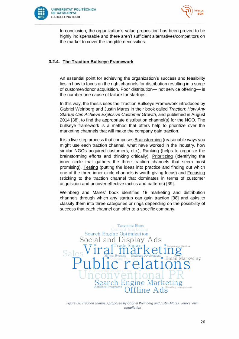
Weinberg and Mares’ book identifies 19 marketing and distribution
channels through which any startup can gain traction [38] and asks to
classify them into three categories or rings depending on the possibility of
success that each channel can offer to a specific company.
Figure 68: Traction channels proposed by Gabriel Weinberg and Justin Mares. Source: own compilation
27
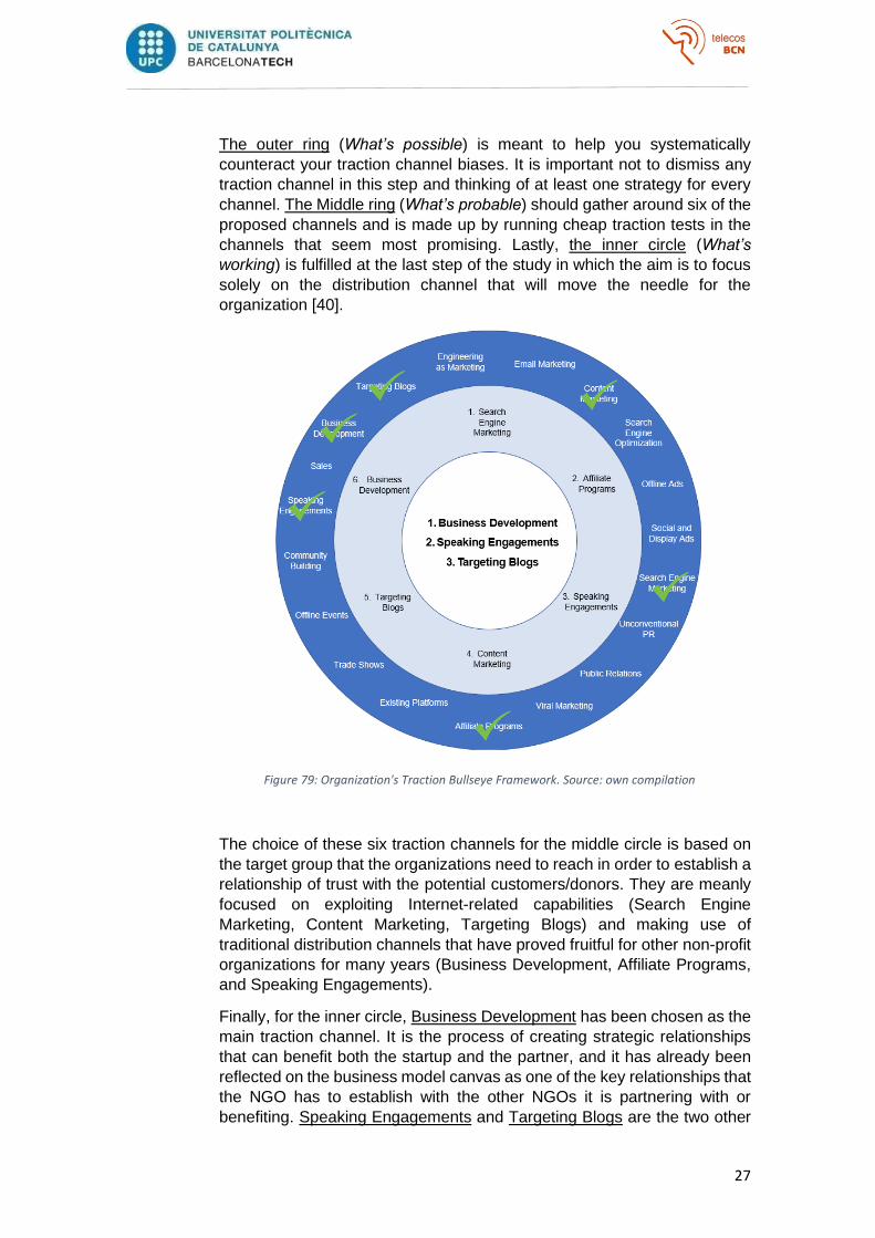
The outer ring (What’s possible) is meant to help you systematically
counteract your traction channel biases. It is important not to dismiss any
traction channel in this step and thinking of at least one strategy for every
channel. The Middle ring (What’s probable) should gather around six of the
proposed channels and is made up by running cheap traction tests in the
channels that seem most promising. Lastly, the inner circle (What’s
working) is fulfilled at the last step of the study in which the aim is to focus
solely on the distribution channel that will move the needle for the
organization [40].
Figure 79: Organization's Traction Bullseye Framework. Source: own compilation
The choice of these six traction channels for the middle circle is based on
the target group that the organizations need to reach in order to establish a
relationship of trust with the potential customers/donors. They are meanly
focused on exploiting Internet-related capabilities (Search Engine
Marketing, Content Marketing, Targeting Blogs) and making use of
traditional distribution channels that have proved fruitful for other non-profit
organizations for many years (Business Development, Affiliate Programs,
and Speaking Engagements).
Finally, for the inner circle, Business Development has been chosen as the
main traction channel. It is the process of creating strategic relationships
that can benefit both the startup and the partner, and it has already been
reflected on the business model canvas as one of the key relationships that
the NGO has to establish with the other NGOs it is partnering with or
benefiting. Speaking Engagements and Targeting Blogs are the two other

28
chosen channels to comprise the inner circle because they are frequented
by most of the target audience and that is where the NGO can engage them
the most (Forums, Congresses, Conferences, Blogs, Reddit, etc.).
29
4. Practical Development
In order to examine the technical challenges and the practical viability of using satellite
communications technologies during a humanitarian response mission, this chapter
covers the key activities that the NGO would need to cover during a hypothetical disaster
response mission based on a real catastrophe that took place in 2019 in Beria,
Mozambique.
4.1. Scenario
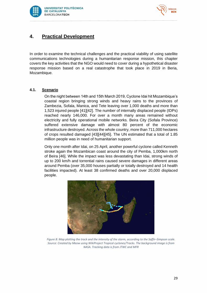
On the night between 14th and 15th March 2019, Cyclone Idai hit Mozambique’s
coastal region bringing strong winds and heavy rains to the provinces of
Zambezia, Sofala, Manica, and Tete leaving over 1,000 deaths and more than
1,523 injured people [41][42]. The number of internally displaced people (IDPs)
reached nearly 146,000. For over a month many areas remained without
electricity and fully operational mobile networks. Beira City (Sofala Province)
suffered extensive damage with almost 80 percent of the economic
infrastructure destroyed. Across the whole country, more than 711,000 hectares
of crops resulted damaged [43][44][45]. The UN estimated that a total of 1.85
million people was in need of humanitarian support.
Only one month after Idai, on 25 April, another powerful cyclone called Kenneth
stroke again the Mozambican coast around the city of Pemba, 1,000km north
of Beira [46]. While the impact was less devastating than Idai, strong winds of
up to 200 km/h and torrential rains caused severe damages in different areas
around Pemba (over 35,000 houses partially or totally destroyed and 14 health
facilities impacted). At least 38 confirmed deaths and over 20,000 displaced
people.
Figure 8: Map plotting the track and the intensity of the storm, according to the Saffir–Simpson scale. Source: Created by Meow using WikiProject Tropical cyclones/Tracks. The background image is from
NASA. Tracking data is from JTWC and MFR
30
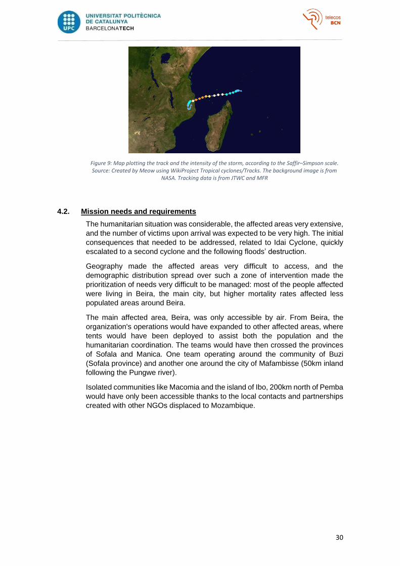
Figure 9: Map plotting the track and the intensity of the storm, according to the Saffir–Simpson scale. Source: Created by Meow using WikiProject Tropical cyclones/Tracks. The background image is from
NASA. Tracking data is from JTWC and MFR
4.2. Mission needs and requirements
The humanitarian situation was considerable, the affected areas very extensive,
and the number of victims upon arrival was expected to be very high. The initial
consequences that needed to be addressed, related to Idai Cyclone, quickly
escalated to a second cyclone and the following floods’ destruction.
Geography made the affected areas very difficult to access, and the
demographic distribution spread over such a zone of intervention made the
prioritization of needs very difficult to be managed: most of the people affected
were living in Beira, the main city, but higher mortality rates affected less
populated areas around Beira.
The main affected area, Beira, was only accessible by air. From Beira, the
organization's operations would have expanded to other affected areas, where
tents would have been deployed to assist both the population and the
humanitarian coordination. The teams would have then crossed the provinces
of Sofala and Manica. One team operating around the community of Buzi
(Sofala province) and another one around the city of Mafambisse (50km inland
following the Pungwe river).
Isolated communities like Macomia and the island of Ibo, 200km north of Pemba
would have only been accessible thanks to the local contacts and partnerships
created with other NGOs displaced to Mozambique.
31
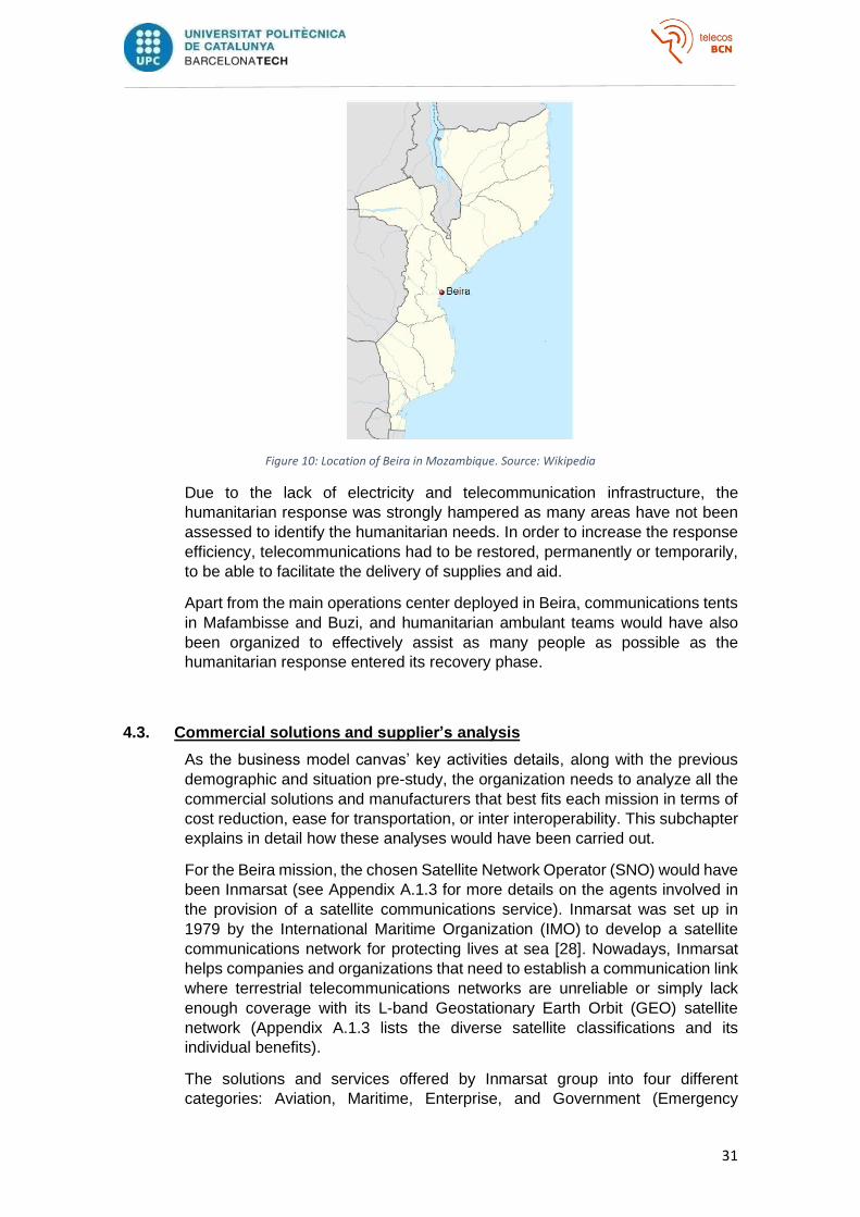
Figure 10: Location of Beira in Mozambique. Source: Wikipedia
Due to the lack of electricity and telecommunication infrastructure, the
humanitarian response was strongly hampered as many areas have not been
assessed to identify the humanitarian needs. In order to increase the response
efficiency, telecommunications had to be restored, permanently or temporarily,
to be able to facilitate the delivery of supplies and aid.
Apart from the main operations center deployed in Beira, communications tents
in Mafambisse and Buzi, and humanitarian ambulant teams would have also
been organized to effectively assist as many people as possible as the
humanitarian response entered its recovery phase.
4.3. Commercial solutions and supplier’s analysis
As the business model canvas’ key activities details, along with the previous
demographic and situation pre-study, the organization needs to analyze all the
commercial solutions and manufacturers that best fits each mission in terms of
cost reduction, ease for transportation, or inter interoperability. This subchapter
explains in detail how these analyses would have been carried out.
For the Beira mission, the chosen Satellite Network Operator (SNO) would have
been Inmarsat (see Appendix A.1.3 for more details on the agents involved in
the provision of a satellite communications service). Inmarsat was set up in
1979 by the International Maritime Organization (IMO) to develop a satellite
communications network for protecting lives at sea [28]. Nowadays, Inmarsat
helps companies and organizations that need to establish a communication link
where terrestrial telecommunications networks are unreliable or simply lack
enough coverage with its L-band Geostationary Earth Orbit (GEO) satellite
network (Appendix A.1.3 lists the diverse satellite classifications and its
individual benefits).
The solutions and services offered by Inmarsat group into four different
categories: Aviation, Maritime, Enterprise, and Government (Emergency
32
response included). Regarding humanitarian disaster response, Inmarsat
delivers reliable, inter-operable satellite communications to meet the needs of
first responders to command, control, and coordinate operational personnel in
the field, whether terrestrial networks are available or not [47].
They offer four different broadband services, each of them specifically designed
for land, sea, or air requirements regarding voice communications, data rates,
security, and reliability. Before deploying the Beira mission, BGAN [48] and
GlobalExpress [49] solutions would have been compared as they are the inland
perfect solutions that the SNO offers:
• BGAN
o Global Coverage
o ‘On-the-move’ and ‘on-the-pause’ mobile communications.
o Data, voice, and video capabilities (800 ms latency)
o Massive volumes of data
o Flexible and portable
o Ease of use
o Low hardware costs
o CAPEX-oriented airtime packages based on typical usage
o Real-time visibility of operations
• GlobalExpress
o Security and reliability end-to-end communications.
o Government-oriented
o Higher data rates
o Higher costs
o Fewer equipment manufacturers
Among these two solutions, BGAN would have been the chosen technology for
the mission because it turns out to be the easiest technology to be used by
novel users (“Plug-and-Play”), and because its interoperability makes it possible
for common laptops and mobile phones to connect to the tents’ Wi-Fi network,
therefore reducing costs and facilitating its use by other NGOs. Although being
the chosen technology, BGAN also has some slight drawbacks such as its cost
(about $4 to $6 per Megabyte transferred), its terminals cost (from $1,600 to
$10,000 or more), and the fact that BGAN terminals need to be manually
pointed.
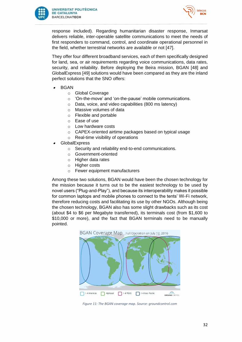
Figure 11: The BGAN coverage map. Source: groundcontrol.com
33
Inmarsat offers an innovative BGAN coverage map made of 4 GEO satellites
(normally 3 satellites are enough for worldwide coverage). The Inmarsat I-4
MEAS (Middle East and ASia) is the 4th (and newest) is its fourth satellite in the
constellation, it was operational on the BGAN network on July 12, 2016, and its
primary objective is to provide more capacity to users in these regions.
Besides choosing the Satellite Network Operator (SNO) and the appropriate
technology to be used, the organization needs to estimate the type and number
of terminals to be deployed, and the suitable manufacturer on the market. The
key resources to be considered are:
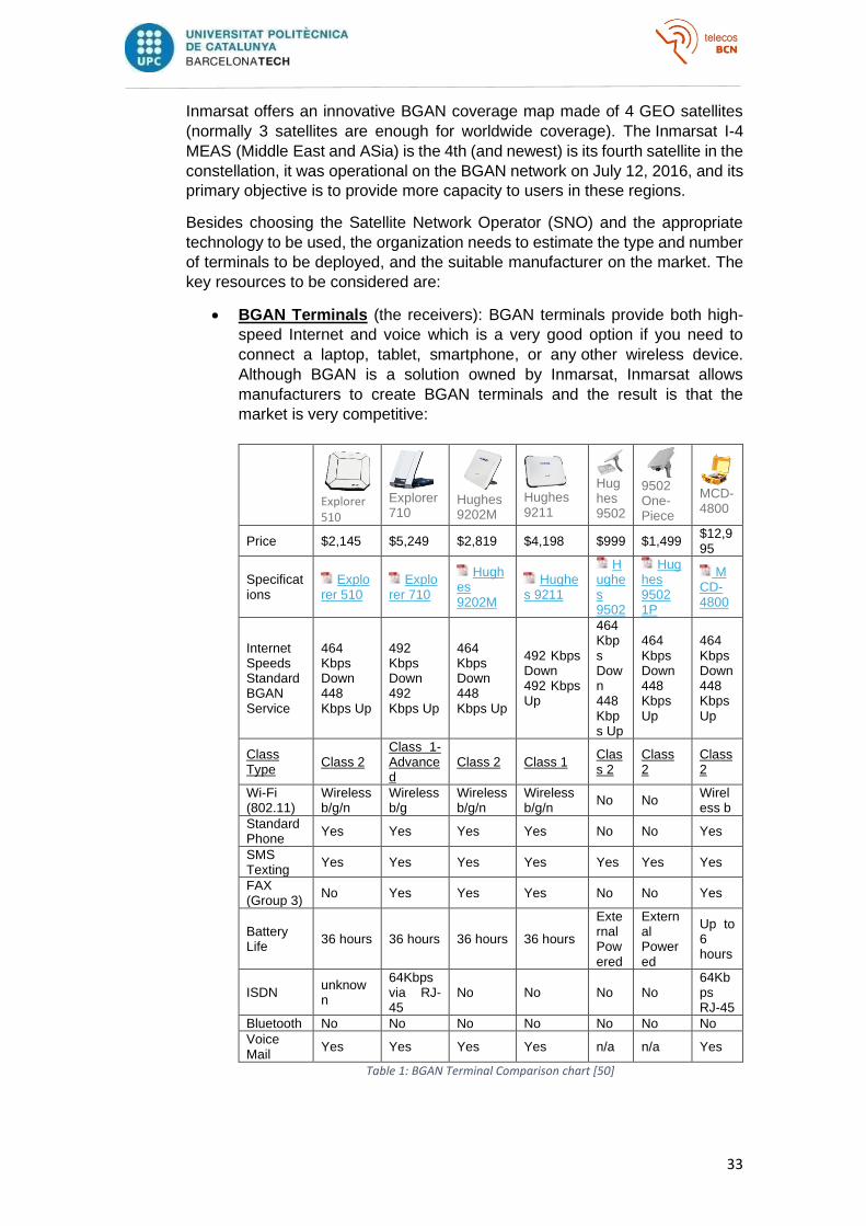
• BGAN Terminals (the receivers): BGAN terminals provide both high-
speed Internet and voice which is a very good option if you need to
connect a laptop, tablet, smartphone, or any other wireless device.
Although BGAN is a solution owned by Inmarsat, Inmarsat allows
manufacturers to create BGAN terminals and the result is that the
market is very competitive:
Explorer 510
Explorer 710
Hughes 9202M
Hughes 9211
Hughes 9502
9502 One-Piece
MCD-4800
Price $2,145 $5,249 $2,819 $4,198 $999 $1,499 $12,995
Specifications
Explorer 510
Explorer 710
Hughes 9202M
Hughes 9211
Hughes 9502
Hughes 9502 1P
MCD-4800
Internet Speeds Standard BGAN Service
464 Kbps Down 448 Kbps Up
492 Kbps Down 492 Kbps Up
464 Kbps Down 448 Kbps Up
492 Kbps Down 492 Kbps Up
464 Kbps Down 448 Kbps Up
464 Kbps Down 448 Kbps Up
464 Kbps Down 448 Kbps Up
Class Type
Class 2 Class 1-Advanced
Class 2 Class 1 Class 2
Class 2
Class 2
Wi-Fi (802.11)
Wireless b/g/n
Wireless b/g
Wireless b/g/n
Wireless b/g/n
No No Wireless b
Standard Phone
Yes Yes Yes Yes No No Yes
SMS Texting
Yes Yes Yes Yes Yes Yes Yes
FAX (Group 3)
No Yes Yes Yes No No Yes
Battery Life
36 hours 36 hours 36 hours 36 hours
External Powered
External Powered
Up to 6 hours
ISDN unknown
64Kbps via RJ-45
No No No No 64Kbps RJ-45
Bluetooth No No No No No No No
Voice Mail
Yes Yes Yes Yes n/a n/a Yes
Table 1: BGAN Terminal Comparison chart [50]

34
• Service Plan: The same market freedom encountered with the BGAN
terminals manufacturers happens with Service Providers (SPs). There
is a vast assortment of SPs specialized in BGAN equipment and service
for offering a wide variety of BGAN plans to fit specific usage
requirements (monthly plans, prepaid Megabytes packages that may be
used during several weeks, unlimited plans, etc. ).
• Telephones: Each terminal carries a sim card that is assigned with two
unique telephone numbers, one for phone calling, and the other for a fax
line. Any standard corded or cordless phone may connect to a BGAN
terminal, but it is advisable to use a standard corded phone (analog
phone) because it only requires a couple of batteries to operate, which
is highly beneficial for power reduction in remote locations and post-
catastrophes situations where the electricity infrastructure may have
been damaged. Depending on the missions, the team may also need to
deploy satellite phones for humanitarian ambulant teams.
• Laptops: In the same way as what happens with telephones, BGAN
terminals acts as a Wi-Fi hotspot that is available for any conventional
laptop, tablet, or smartphone to connect to. The data rate available for
high-speed connection depends on the class (1, 2, or 3) of the chosen
terminal, and they can usually host more than 11 (The Cobham Explorer
510 capacity) users at the same time connected to the Wi-Fi network
[51].
• Others: Databases, power supplies, solar panels, tents, desks, …
4.4. Deployment and data measurement
As stated in the previous subchapters, the mission deployment would have
comprised three fixed satellite communications tents and three ambulant teams
where the organization’s volunteers and employees would have been patrolling
the area equipped with satellite phones vehicular BGAN terminals:
35
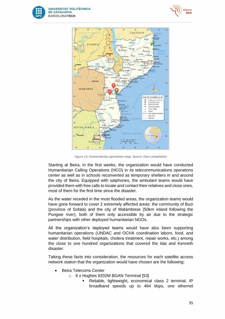
Figure 12: Humanitarian operations map. Source: Own compilation
Starting at Beira, in the first weeks, the organization would have conducted
Humanitarian Calling Operations (HCO) in its telecommunications operations
center as well as in schools reconverted as temporary shelters in and around
the city of Beira. Equipped with satphones, the ambulant teams would have
provided them with free calls to locate and contact their relatives and close ones,
most of them for the first time since the disaster.
As the water receded in the most flooded areas, the organization teams would
have gone forward to cover 2 extremely affected areas: the community of Buzi
(province of Sofala) and the city of Mafambisse (50km inland following the
Pungwe river), both of them only accessible by air due to the strategic
partnerships with other deployed humanitarian NGOs.
All the organization’s deployed teams would have also been supporting
humanitarian operations (UNDAC and OCHA coordination labors, food, and
water distribution, field hospitals, cholera treatment, repair works, etc.) among
the close to one hundred organizations that covered the Idai and Kenneth
disaster.
Taking these facts into consideration, the resources for each satellite access
network station that the organization would have chosen are the following:
• Beira Telecoms Center
o 6 x Hughes 9202M BGAN Terminal [53]
▪ Reliable, lightweight, economical class 2 terminal, IP
broadband speeds up to 464 kbps, one ethernet
36
connection, supports circuit-switched voice and fax calls
via a two-line RJ11 plug, up to 36h battery live.
▪ Thought for fixed stations.
▪ 2,819 $
o 20 x IsatPhone 2 (satellite phone) [55]
▪ Direct and worldwide connection with GEO Satellites
(fewer dropped calls), excellent call quality (2.4 kbps), up
to 160h battery live, low calling rates (0.78$ per minute),
multilanguage,
▪ 800$
o 10 x AT&T 688 [56]
▪ Conventional corded telephone, no AC needed.
▪ 13$
o 10 x Acer Chromebook 315
▪ Chrome OS, AMD A4-9120C Dual-core (2 núcleos) 1,60
GHz, 4 GB, DDR4 SDRAM, 32 GB Memoria flash.
▪ 330€
• Beira humanitarian ambulant teams
o 1 x Hughes 9450TW 19.5" (BGAN terminal) [54]
▪ Includes the 9450 transceiver and the larger C10 - 19.5"
diameter antenna that offers multi-band Wi-Fi
connectivity up to 492 kbps speeds and 30 meters range,
4 ethernet connections, and circuit-switched voice and
fax calls via a two-line RJ11 plug.
▪ Thought for vehicular stations.
▪ 8,795 $
o 4 x IsatPhone 2 (satellite phone) [55]
▪ Direct and worldwide connection with GEO Satellites
(fewer dropped calls), excellent call quality (2.4 kbps), up
to 160h battery live, low calling rates (0.78$ per minute),
multilanguage.
▪ 800$ each.
o 2 x AT&T 688 [56]
▪ Conventional corded telephone, no AC needed.
▪ 13$ each.
o 4 x Acer Chromebook 315
▪ Chrome OS, AMD A4-9120C Dual-core (2 núcleos) 1,60
GHz, 4 GB, DDR4 SDRAM, 32 GB Memoria flash.
▪ 330€ each.
• Buzi tent
o 2 x Hughes 9202M BGAN Terminal [53]
▪ Reliable, lightweight, economical class 2 terminal, IP
broadband speeds up to 464 kbps, one ethernet
connection, supports circuit-switched voice and fax calls
via a two-line RJ11 plug, up to 36h battery live.
▪ Thought for fixed stations.
▪ 2,819 $
o 6 x IsatPhone 2 (satellite phone) [55]
▪ Direct and worldwide connection with GEO Satellites
(fewer dropped calls), excellent call quality (2.4 kbps), up

37
to 160h battery live, low calling rates (0.78$ per minute),
multilanguage.
▪ 800$ each.
o 3 x AT&T 688 [56]
▪ Conventional corded telephone, no AC needed.
▪ 13$ each.
o 2 x Acer Chromebook 315
▪ Chrome OS, AMD A4-9120C Dual-core (2 núcleos) 1,60
GHz, 4 GB, DDR4 SDRAM, 32 GB Memoria flash.
▪ 330€ each.
• Mafambisse tent
o 2 x Hughes 9202M BGAN Terminal [53]
▪ Reliable, lightweight, economical class 2 terminal, IP
broadband speeds up to 464 kbps, one ethernet
connection, supports circuit-switched voice and fax calls
via a two-line RJ11 plug, up to 36h battery live.
▪ Though for fixed stations.
▪ 2,819 $
o 6 x IsatPhone 2 (satellite phone) [55]
▪ Direct and worldwide connection with GEO Satellites
(fewer dropped calls), excellent call quality (2.4 kbps), up
to 160h battery live, low calling rates (0.78$ per minute),
multilanguage.
▪ 800$ each.
o 3 x AT&T 688 [56]
▪ Conventional corded telephone, no AC needed.
▪ 13$ each.
o 6 x Acer Chromebook 315
▪ Chrome OS, AMD A4-9120C Dual-core (2 núcleos) 1,60
GHz, 4 GB, DDR4 SDRAM, 32 GB Memoria flash.
▪ 330€ each.
• Macomia ambulant team
o 1 x Hughes 9450TW 19.5" (BGAN terminal) [54]
▪ Includes the 9450 transceiver and the larger C10 - 19.5"
diameter antenna that offers multi-band Wi-Fi
connectivity up to 492 kbps speeds and 30 meters range,
4 ethernet connections, and circuit-switched voice and
fax calls via a two-line RJ11 plug.
▪ Thought for vehicular stations.
▪ 8,795 $
o 6 x IsatPhone 2 (satellite phone) [55]
▪ Direct and worldwide connection with GEO Satellites
(fewer dropped calls), excellent call quality (2.4 kbps), up
to 160h battery live, low calling rates (0.78$ per minute),
multilanguage.
▪ 800$ each.
o 2 x AT&T 688 [56]
▪ Conventional corded telephone, no AC needed.
▪ 13$ each.
o 2 x Acer Chromebook 315
38
▪ Chrome OS, AMD A4-9120C Dual-core (2 núcleos) 1,60
GHz, 4 GB, DDR4 SDRAM, 32 GB Memoria flash.
▪ 330€ each.
• Ilha Ibo ambulant team
o 1 x Hughes 9450TW 19.5" (BGAN terminal) [54]
▪ Includes the 9450 transceiver and the larger C10 - 19.5"
diameter antenna that offers multi-band Wi-Fi
connectivity up to 492 kbps speeds and 30 meters range,
4 ethernet connections, and circuit-switched voice and
fax calls via a two-line RJ11 plug.
▪ Thought for vehicular stations.
▪ 8,795 $
o 6 x IsatPhone 2 (satellite phone) [55]
▪ Direct and worldwide connection with GEO Satellites
(fewer dropped calls), excellent call quality (2.4 kbps), up
to 160h battery live, low calling rates (0.78$ per minute),
multilanguage.
▪ 800$ each.
o 2 x AT&T 688 [56]
▪ Conventional corded telephone, no AC needed.
▪ 13$ each.
o 2 x Acer Chromebook 315
▪ Chrome OS, AMD A4-9120C Dual-core (2 núcleos) 1,60
GHz, 4 GB, DDR4 SDRAM, 32 GB Memoria flash.
▪ 330€ each.
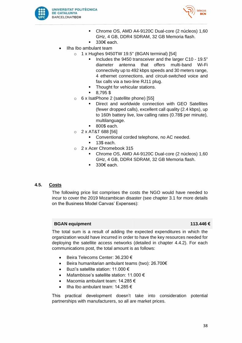
4.5. Costs
The following price list comprises the costs the NGO would have needed to
incur to cover the 2019 Mozambican disaster (see chapter 3.1 for more details
on the Business Model Canvas’ Expenses):
BGAN equipment 113.446 €
The total sum is a result of adding the expected expenditures in which the
organization would have incurred in order to have the key resources needed for
deploying the satellite access networks (detailed in chapter 4.4.2). For each
communications post, the total amount is as follows:
• Beira Telecoms Center: 36.230 €
• Beira humanitarian ambulant teams (two): 26.700€
• Buzi’s satellite station: 11.000 €
• Mafambisse’s satellite station: 11.000 €
• Macomia ambulant team: 14.285 €
• Ilha Ibo ambulant team: 14.285 €
This practical development doesn’t take into consideration potential
partnerships with manufacturers, so all are market prices.
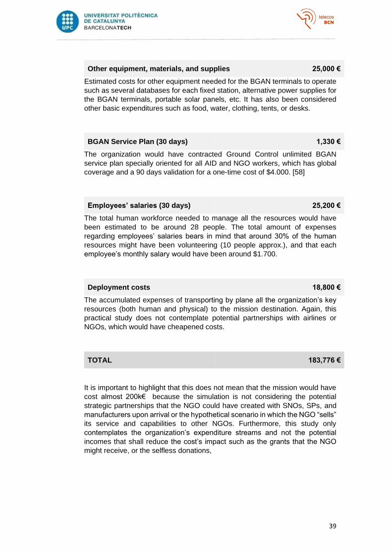
39
Other equipment, materials, and supplies 25,000 €
Estimated costs for other equipment needed for the BGAN terminals to operate
such as several databases for each fixed station, alternative power supplies for
the BGAN terminals, portable solar panels, etc. It has also been considered
other basic expenditures such as food, water, clothing, tents, or desks.
BGAN Service Plan (30 days) 1,330 €
The organization would have contracted Ground Control unlimited BGAN
service plan specially oriented for all AID and NGO workers, which has global
coverage and a 90 days validation for a one-time cost of $4.000. [58]
Employees’ salaries (30 days) 25,200 €
The total human workforce needed to manage all the resources would have
been estimated to be around 28 people. The total amount of expenses
regarding employees’ salaries bears in mind that around 30% of the human
resources might have been volunteering (10 people approx.), and that each
employee’s monthly salary would have been around $1.700.
Deployment costs 18,800 €
The accumulated expenses of transporting by plane all the organization’s key
resources (both human and physical) to the mission destination. Again, this
practical study does not contemplate potential partnerships with airlines or
NGOs, which would have cheapened costs.
TOTAL 183,776 €
It is important to highlight that this does not mean that the mission would have
cost almost 200k€ because the simulation is not considering the potential
strategic partnerships that the NGO could have created with SNOs, SPs, and
manufacturers upon arrival or the hypothetical scenario in which the NGO “sells”
its service and capabilities to other NGOs. Furthermore, this study only
contemplates the organization’s expenditure streams and not the potential
incomes that shall reduce the cost’s impact such as the grants that the NGO
might receive, or the selfless donations,
40
5. Conclusions
This master’s thesis’ main objective was to present a telecommunications-related non-
profit startup business idea and to prove its feasibility.
The proposed NGO is specialized in dimensioning and deploying Satellite Access
Networks for humanitarian disaster response missions in which people may be suffering
from temporary uncommunication. Its definition falls back on The Business Model
Canvas for NGOs introduced by Judith Sanderse in 2014 [21] as the cornerstone for
developing the new NGO business model and, thanks to its nine building blocks, it
describes the NGO’s value propositions, ultimate beneficiaries, infrastructure, and
finances.
The key to identifying potential needs and missions, coordinating joint humanitarian
responses, and cost-reducing lies in establishing strategic partnerships with potential
competitors and suppliers. Once the business structure is depicted, the thesis uses a
perceptual map to position the NGO within the market and to highlight the presence of
those scarce potential competitors that were first thought to be non-existent, and with
whom the NGO will need to reach an agreement.
The most suitable strategy for the organization’s characteristics and the markets in order
to impact as many people as possible and in the best possible way is enabled with the
help of several frameworks like SWOT, the Porter’s Five Forces, or the Traction Bullseye.
They go even further and evidence that there is no way for the business idea to succeed
and be feasible without securing those NGO’s key partnerships.
Moreover, the final chapter demonstrates the practical implementation that the business
idea has. It describes how the NGO would have performed on a hypothetical disaster
response mission based on a real catastrophe that took place in 2019 in Beria,
Mozambique, and how necessary it would actually have been. The NGO’s structural
strength alongside the maturity of satellite technologies proves that such a non-profit
non-governmental organization can smoothly operate in the current market and that it
can find its own market niche as long as strategic partnerships are taken good care of.
The proposed NGO can perfectly fit in the existing framework, where the number of
critical situations in need of this kind of humanitarian response has been constantly
increasing over the last decades, and where the scarce existing competitors actually turn
out to be key partners for the business plan to succeed.
41
A. Appendixes
A.1 Environment Analysis
In order to analyze the internal and external environment of the organization, its
study is divided into three domains to facilitate its understanding:
• Beginning by analyzing the macroeconomic environment in which the
NGO operates. It allows understanding the economic situation of the
country where the organization is located and, therefore, the solidity of
the financing channels that the organization will have;
• Next, a juridical-legal analysis that explains under which decrees and
jurisdictions the organization should be founded;
• And, finally, a technological analysis where the technologies exploited by
the NGO in potential projects are developed. It also helps to analyze
whether their maturity or the existence of substitute technologies may be
of any impact on the organization itself.
A.1.1 Economic analysis
The meaning of carrying out an economic analysis is to understand the
economic trend of the environment in which the organization operates, to
assimilate the behaviors of the different economic agents that have a direct
impact on it, such as its investors or potential partners.
As the organization is yet to be launched, the thesis assumes that the
organization coordinates its activity from Barcelona, Spain. During this
chapter, the four main macroeconomic indicators in Spain affecting the
NGO are analyzed, comparing them with those of other countries in order
to obtain a complete perspective of the impact of the different social and
political phenomena.
• Gross Domestic Product (GDP)
The first factor to be analyzed, GDP, reflects the economic growth of a
nation or a region through the value of its production of goods and services.
Economic growth is a cyclical process when goods that are produced by
the companies of a country are consumed by its citizens; it impacts on
higher incomes and better profits for companies, which can later be
invested in hiring staff (thus affecting the consumer again).
The main financing channels that an NGO has can be grouped into the
public initiative and private initiative. In the case of public funds, the
organization can receive subsidies from the different administrations —
local, regional, state, or international— which can amount to up to 60% of
the organization's funding streams. If you think about private financing, it
includes both donations from companies and entities aware of their social
impact, as well as donations from individuals or Other People’s Money

42
(OPM) who wish to support the work of the NGO through one-off or
recurring donations. Other examples of private financing channels can be
crowdfunding, growfunding, collaborations with brands that help lower the
cost of the services provided, patronage, selling merchandising, renting /
leasing of terminals or the bandwidth contracted to other organizations, etc.
Growth in GDP is reflected in higher consumption and greater purchasing
power of the population and, by extension, a greater willingness of citizens
and administrations to invest in NGOs.
As shown below by the data extracted from the National Institute of
Statistics on the quarterly and annual variation of GDP in Spain, the
constant growth that Spain has been enjoying during the last three years
gives way to a phase of technical recession after registering in the second
quarter in 2020 the largest quarterly drop in its historical series, which
began in 1970.
TERM VALUE (%)
2020T2 -17,7921
2020T1 -5,2495
2019T4 0,4148
2019T3 0,3538
2019T2 0,3781
2019T1 0,5221
2018T4 0,5542
2018T3 0,6105
2018T2 0,5203
2018T1 0,5496
2017T4 0,6258
2017T3 0,5773
2017T2 1,0737
2017T1 0,7940
Table 2: Quarterly variation of the Gross Domestic Product (GDP) at market prices in Spain. Source: Spanish National Institute of Statistics (INE)
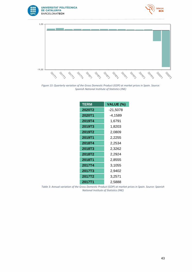
43
Figure 13: Quarterly variation of the Gross Domestic Product (GDP) at market prices in Spain. Source: Spanish National Institute of Statistics (INE)
TERM VALUE (%)
2020T2 -21,5078
2020T1 -4,1589
2019T4 1,6791
2019T3 1,8203
2019T2 2,0809
2019T1 2,2255
2018T4 2,2534
2018T3 2,3262
2018T2 2,2924
2018T1 2,8555
2017T4 3,1055
2017T3 2,9402
2017T2 3,2571
2017T1 2,5888
Table 3: Annual variation of the Gross Domestic Product (GDP) at market prices in Spain. Source: Spanish National Institute of Statistics (INE)
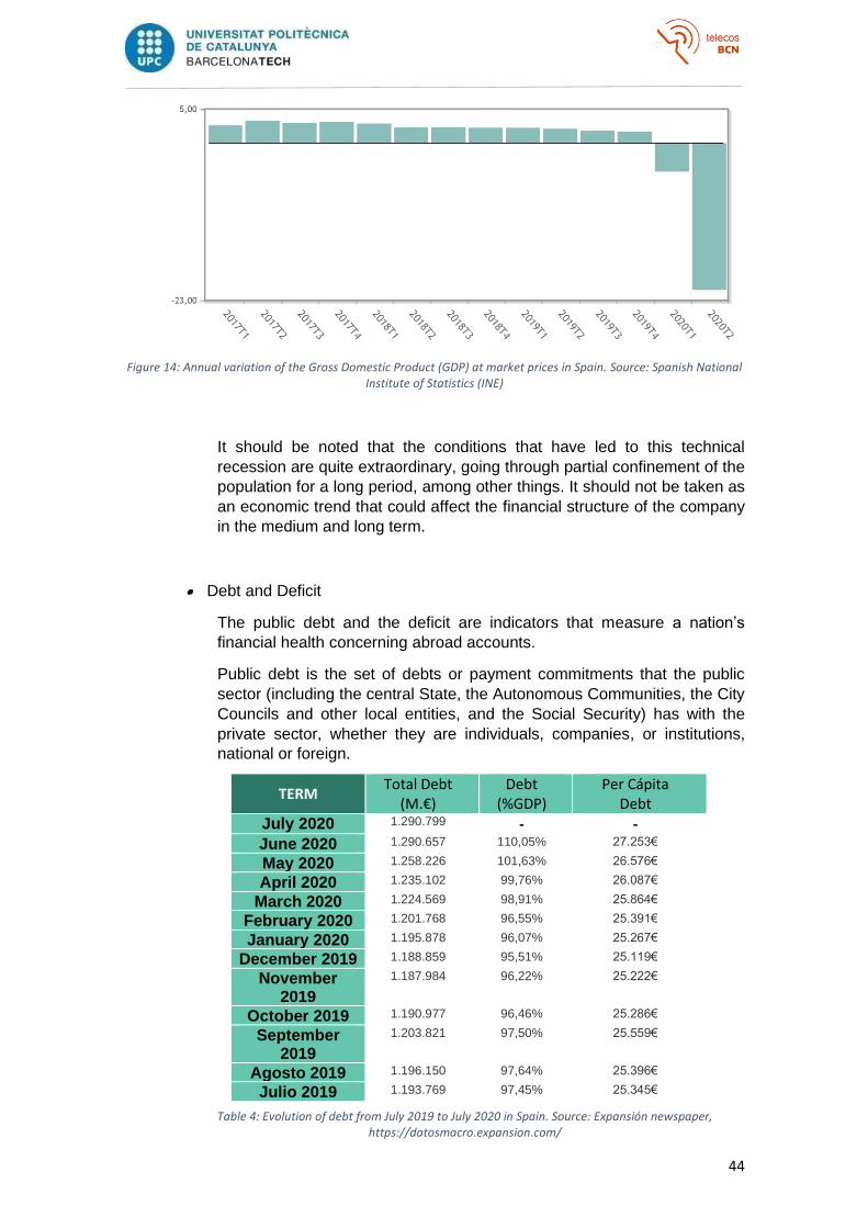
44
Figure 14: Annual variation of the Gross Domestic Product (GDP) at market prices in Spain. Source: Spanish National Institute of Statistics (INE)
It should be noted that the conditions that have led to this technical
recession are quite extraordinary, going through partial confinement of the
population for a long period, among other things. It should not be taken as
an economic trend that could affect the financial structure of the company
in the medium and long term.
• Debt and Deficit
The public debt and the deficit are indicators that measure a nation’s
financial health concerning abroad accounts.
Public debt is the set of debts or payment commitments that the public
sector (including the central State, the Autonomous Communities, the City
Councils and other local entities, and the Social Security) has with the
private sector, whether they are individuals, companies, or institutions,
national or foreign.
TERM
Total Debt (M.€)
Debt (%GDP)
Per Cápita Debt
July 2020 1.290.799 - -
June 2020 1.290.657 110,05% 27.253€
May 2020 1.258.226 101,63% 26.576€
April 2020 1.235.102 99,76% 26.087€
March 2020 1.224.569 98,91% 25.864€
February 2020 1.201.768 96,55% 25.391€
January 2020 1.195.878 96,07% 25.267€
December 2019 1.188.859 95,51% 25.119€
November 2019
1.187.984 96,22% 25.222€
October 2019 1.190.977 96,46% 25.286€
September 2019
1.203.821 97,50% 25.559€
Agosto 2019 1.196.150 97,64% 25.396€
Julio 2019 1.193.769 97,45% 25.345€
Table 4: Evolution of debt from July 2019 to July 2020 in Spain. Source: Expansión newspaper, https://datosmacro.expansion.com/

45
During the second quarter of 2020, in Spain, public debt grew more than
66,000 M.€, exceeding for the first time the 100% of GDP border.
Comparing the data on public debt in Spain at the end of 2019, against
other countries of the European Union, it can be seen that the Spanish
situation was not an isolated phenomenon in the Union, but rather several
countries, and especially in southern Europe, suffer from a similar situation.
Country Total Debt
(M.€) Debt
(%GDP) Per Cápita
Debt
Spain 1.188.859 95,50% 25.119€
Germany 2.053.033 59,80% 24.686€
United Kingdom 2.223.544 85,40% 33.175€
France 2.380.106 98,10% 35.472€
Italy 2.409.841 134,80% 40.001€
Portugal 249.980 117,70% 24.280€
Table 5: Public Debt comparison in Europe as of December 2019. Source: Expansión newspaper, https://datosmacro.expansion.com/
On the other hand, the deficit is the difference between the operations of
public income and expenditure during the budget year. We speak of a deficit
when the budget balance is negative, while if the balance is positive, the
country is in surplus.
The public deficit appears because, for various reasons, the State's income
(mostly taxes) are insufficient to cover all spending needs (education,
health, pensions, unemployment benefits ...).
Figure 15: Public deficit comparison by country as of December 2019. Source: Expansión newspaper, https://datosmacro.expansion.com/
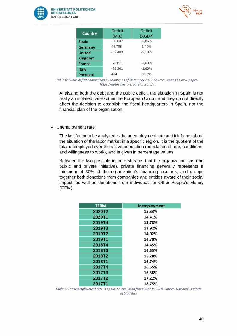
46
Country Deficit (M.€)
Deficit (%GDP)
Spain -35.637 -2,86%
Germany 49.788 1,40%
United Kingdom
-52.483 -2,10%
France -72.811 -3,00%
Italy -29.301 -1,60%
Portugal 404 0,20%
Table 6: Public deficit comparison by country as of December 2019. Source: Expansión newspaper, https://datosmacro.expansion.com/v
Analyzing both the debt and the public deficit, the situation in Spain is not
really an isolated case within the European Union, and they do not directly
affect the decision to establish the fiscal headquarters in Spain, nor the
financial plan of the organization.
• Unemployment rate
The last factor to be analyzed is the unemployment rate and it informs about
the situation of the labor market in a specific region. It is the quotient of the
total unemployed over the active population (population of age, conditions,
and willingness to work), and is given in percentage values.
Between the two possible income streams that the organization has (the
public and private initiative), private financing generally represents a
minimum of 30% of the organization's financing incomes, and groups
together both donations from companies and entities aware of their social
impact, as well as donations from individuals or Other People’s Money
(OPM).
TERM Unemployment
2020T2 15,33%
2020T1 14,41%
2019T4 13,78%
2019T3 13,92%
2019T2 14,02%
2019T1 14,70%
2018T4 14,45%
2018T3 14,55%
2018T2 15,28%
2018T1 16,74%
2017T4 16,55%
2017T3 16,38%
2017T2 17,22%
2017T1 18,75% Table 7: The unemployment rate in Spain. An evolution from 2017 to 2020. Source: National Institute
of Statistics
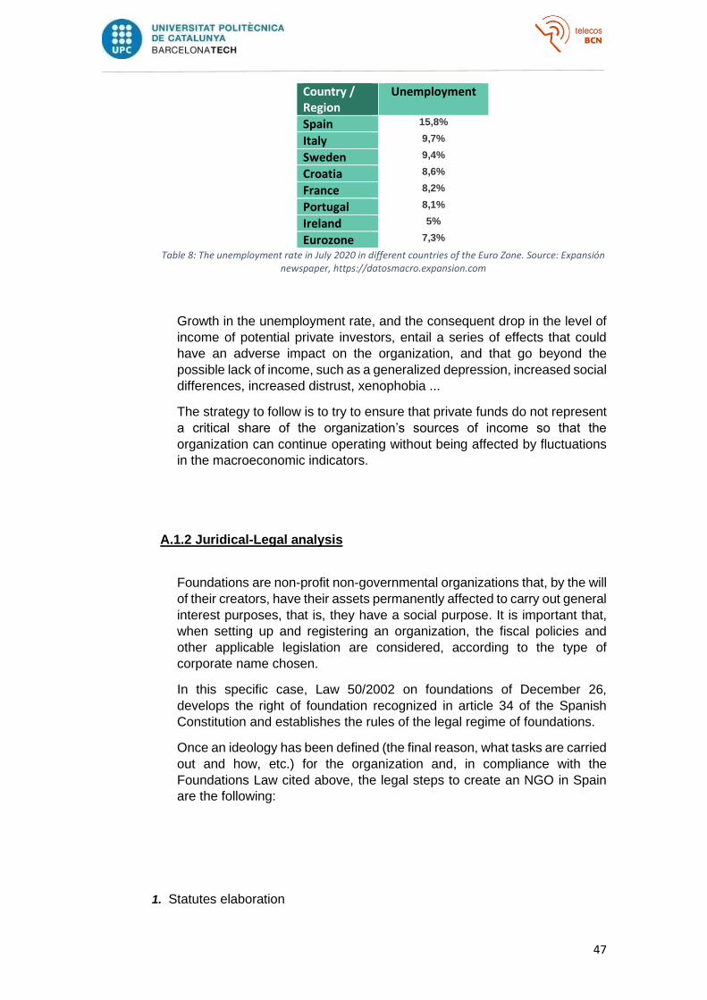
47
Country / Region
Unemployment
Spain 15,8%
Italy 9,7%
Sweden 9,4%
Croatia 8,6%
France 8,2%
Portugal 8,1%
Ireland 5%
Eurozone 7,3%
Table 8: The unemployment rate in July 2020 in different countries of the Euro Zone. Source: Expansión newspaper, https://datosmacro.expansion.com
Growth in the unemployment rate, and the consequent drop in the level of
income of potential private investors, entail a series of effects that could
have an adverse impact on the organization, and that go beyond the
possible lack of income, such as a generalized depression, increased social
differences, increased distrust, xenophobia ...
The strategy to follow is to try to ensure that private funds do not represent
a critical share of the organization’s sources of income so that the
organization can continue operating without being affected by fluctuations
in the macroeconomic indicators.
A.1.2 Juridical-Legal analysis
Foundations are non-profit non-governmental organizations that, by the will
of their creators, have their assets permanently affected to carry out general
interest purposes, that is, they have a social purpose. It is important that,
when setting up and registering an organization, the fiscal policies and
other applicable legislation are considered, according to the type of
corporate name chosen.
In this specific case, Law 50/2002 on foundations of December 26,
develops the right of foundation recognized in article 34 of the Spanish
Constitution and establishes the rules of the legal regime of foundations.
Once an ideology has been defined (the final reason, what tasks are carried
out and how, etc.) for the organization and, in compliance with the
Foundations Law cited above, the legal steps to create an NGO in Spain
are the following:
1. Statutes elaboration
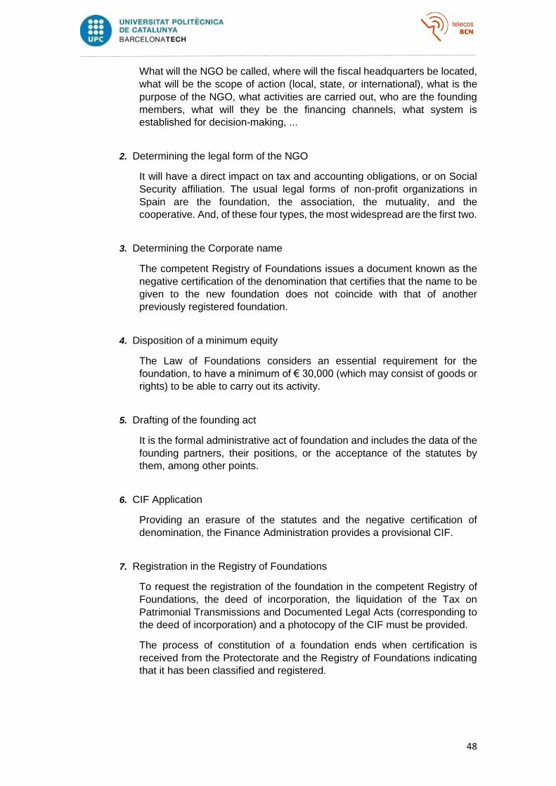
48
What will the NGO be called, where will the fiscal headquarters be located,
what will be the scope of action (local, state, or international), what is the
purpose of the NGO, what activities are carried out, who are the founding
members, what will they be the financing channels, what system is
established for decision-making, ...
2. Determining the legal form of the NGO
It will have a direct impact on tax and accounting obligations, or on Social
Security affiliation. The usual legal forms of non-profit organizations in
Spain are the foundation, the association, the mutuality, and the
cooperative. And, of these four types, the most widespread are the first two.
3. Determining the Corporate name
The competent Registry of Foundations issues a document known as the
negative certification of the denomination that certifies that the name to be
given to the new foundation does not coincide with that of another
previously registered foundation.
4. Disposition of a minimum equity
The Law of Foundations considers an essential requirement for the
foundation, to have a minimum of € 30,000 (which may consist of goods or
rights) to be able to carry out its activity.
5. Drafting of the founding act
It is the formal administrative act of foundation and includes the data of the
founding partners, their positions, or the acceptance of the statutes by
them, among other points.
6. CIF Application
Providing an erasure of the statutes and the negative certification of
denomination, the Finance Administration provides a provisional CIF.
7. Registration in the Registry of Foundations
To request the registration of the foundation in the competent Registry of
Foundations, the deed of incorporation, the liquidation of the Tax on
Patrimonial Transmissions and Documented Legal Acts (corresponding to
the deed of incorporation) and a photocopy of the CIF must be provided.
The process of constitution of a foundation ends when certification is
received from the Protectorate and the Registry of Foundations indicating
that it has been classified and registered.

49
A.1.3 Technological Analysis
Since the first artificial satellite (Sputnik-1) dedicated to sending
atmospheric and climatic data, broadcasting in the 20 and 40 MHz bands,
was put into orbit in 1957, passing through the first satellites that supported
bidirectional voice circuits in the middle of the decade of the 60, or the first
satellite system LEO (Low Earth Orbit) of telephone communications at the
end of the 90; many have been the advances that have occurred in satellite
communications systems to this day.
The first operational satellites whose main function was the provision of
communications systems for military, governmental, or scientific purposes;
were adapted to exploit the commercial potential of this technology. Thus,
in 1964 the INTELSAT (International Telecommunications Satellite
Organization) consortium was formed, which would be responsible for
launching the first satellites (Intelsat I, II, and III) capable of offering more
than 240 voice circuits or a bidirectional television channel for the purpose
of commercial.
As technology advanced and production costs became cheaper, more
companies and associations began to build satellites to meet the needs of
different states, firms, navigation companies, and other organizations with
large needs for the volume of communications traffic.
• Types of Satellites
The most common way of classifying satellites is according to the altitude
of the orbital plane concerning the earth's surface, although they can also
be distinguished according to the type of orbit they draw, or the earth plane
on which they draw that orbit:
o According to the type of Orbit,
▪ Circular satellites with the center of the orbit at the center of the
Earth
▪ Elliptical satellites with one of their foci in the center of the earth
o According to the plane of the Earth in which they orbit,
▪ Equatorial satellites
▪ Polar satellites whose orbit passes through both poles
▪ Other types of orbits o According to the altitude of the orbital plane with respect to the earth's
surface, ▪ Low Earth Orbit (LEO)
• Orbits below 1,200km altitude
• Orbital periods of 1.5-2 hours
• Its coverage area has a diameter of 8,000km
• Approx. 40 satellites for full coverage
• Delays under 20ms
• Susceptible to the Doppler effect and atmospheric
conditions
50
▪ Medium Earth Orbit (MEO)
• Orbit at a distance from the earth's surface of between
5,000 and 12,000 km
• 6-hour orbital period
• Approx. 10-15 satellites required for full coverage
• Delays under 50ms
▪ Geostationary Earth Orbit (GEO).
• Located approximately 36,000 km from the earth's surface
• They orbit at the same angular speed as the Earth, so they
appear static
• They cover 42.2% of the earth's surface, so a network with
3 GEO satellites a priori would cover the entire Earth.
• Delays of 0.25s (very high)
• Structure of a satellite communications system
A basic satellite communications system is usually made up of three
segments:
The Satellite
The central point of the network, a repeater station that amplifies, changes
the band and retransmits the received radio signal, to establish connections
between ground stations that are under its coverage area. The main
components of the satellite are:
▪ Communication Payload, composed of the transponders,
responsible for forming communication channels between the
receiving antenna and the transmitter; and the antenna
subsystem, responsible for capturing and emitting the radio signal.
Usually, transponders operate under the bent pipe principle, which
consists of emitting to Earth the same signal that it has received
but amplified and changing the frequency of the uplink channel to
that of the downlink. On the other hand, the most modern and
complex satellites use on-board processing, to be able to
demodulate and decode the received signal and recode and
modulate it before transmitting it back to Earth.
Year Satellite # of
Transponders Electrical
Power Launch mass
Life expectancy
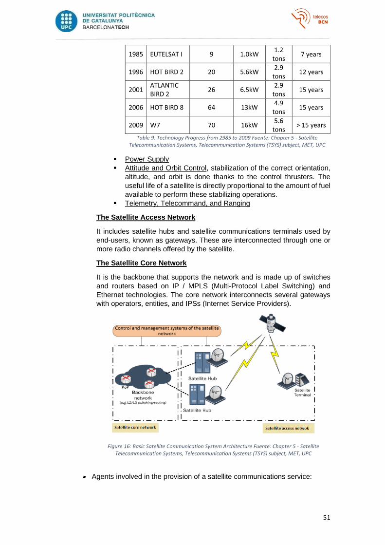
51
1985 EUTELSAT I 9 1.0kW 1.2
tons 7 years
1996 HOT BIRD 2 20 5.6kW 2.9
tons 12 years
2001 ATLANTIC BIRD 2
26 6.5kW 2.9
tons 15 years
2006 HOT BIRD 8 64 13kW 4.9
tons 15 years
2009 W7 70 16kW 5.6
tons > 15 years
Table 9: Technology Progress from 2985 to 2009 Fuente: Chapter 5 - Satellite Telecommunication Systems, Telecommunication Systems (TSYS) subject, MET, UPC
▪ Power Supply
▪ Attitude and Orbit Control, stabilization of the correct orientation,
altitude, and orbit is done thanks to the control thrusters. The
useful life of a satellite is directly proportional to the amount of fuel
available to perform these stabilizing operations.
▪ Telemetry, Telecommand, and Ranging
The Satellite Access Network
It includes satellite hubs and satellite communications terminals used by
end-users, known as gateways. These are interconnected through one or
more radio channels offered by the satellite.
The Satellite Core Network
It is the backbone that supports the network and is made up of switches
and routers based on IP / MPLS (Multi-Protocol Label Switching) and
Ethernet technologies. The core network interconnects several gateways
with operators, entities, and IPSs (Internet Service Providers).
Figure 16: Basic Satellite Communication System Architecture Fuente: Chapter 5 - Satellite Telecommunication Systems, Telecommunication Systems (TSYS) subject, MET, UPC
• Agents involved in the provision of a satellite communications service:
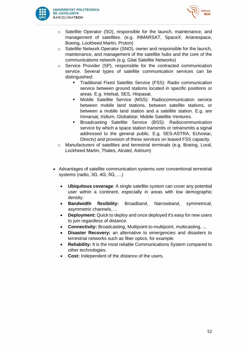
52
o Satellite Operator (SO), responsible for the launch, maintenance, and
management of satellites. (e.g. INMARSAT, SpaceX, Arianespace,
Boeing, Lockheed Martin, Proton)
o Satellite Network Operator (SNO), owner and responsible for the launch,
maintenance, and management of the satellite hubs and the core of the
communications network (e.g. Gilat Satellite Networks)
o Service Provider (SP), responsible for the contracted communication
service. Several types of satellite communication services can be
distinguished:
▪ Traditional Fixed Satellite Service (FSS): Radio communication
service between ground stations located in specific positions or
areas. E.g. Intelsat, SES, Hispasat.
▪ Mobile Satellite Service (MSS): Radiocommunication service
between mobile land stations, between satellite stations, or
between a mobile land station and a satellite station. E.g. are
Inmarsat, Iridium, Globalstar, Mobile Satellite Ventures.
▪ Broadcasting Satellite Service (BSS): Radiocommunication
service by which a space station transmits or retransmits a signal
addressed to the general public. E.g. SES-ASTRA, Echostar,
Directv) and provision of these services on leased FSS capacity.
o Manufacturers of satellites and terrestrial terminals (e.g. Boeing, Loral,
Lockheed Martin, Thales, Alcatel, Astrium)
• Advantages of satellite communication systems over conventional terrestrial
systems (radio, 3G, 4G, 5G, …)
• Ubiquitous coverage: A single satellite system can cover any potential
user within a continent, especially in areas with low demographic
density.
• Bandwidth flexibility: Broadband, Narrowband, symmetrical,
asymmetric channels, ...
• Deployment: Quick to deploy and once deployed it's easy for new users
to join regardless of distance.
• Connectivity: Broadcasting, Multipoint-to-multipoint, multicasting, ...
• Disaster Recovery: an alternative to emergencies and disasters to
terrestrial networks such as fiber optics, for example.
• Reliability: It is the most reliable Communications System compared to
other technologies.
• Cost: Independent of the distance of the users.

53
Bibliography
1. Beven, John L. II; Avila, Lixion A.; Blake, Eric S.; Brown, Daniel P.; Franklin,
James L.; Knabb, Richard D.; Pasch, Richard J.; Rhome, Jamie R.; Stewart,
Stacy R. (March 2008). "Annual Summary: Atlantic Hurricane Season of
2005" (PDF). Monthly Weather Review. 136 (3): 1131–
1141. Bibcode:2008MWRv..136.1109B. CiteSeerX 10.1.1.212.8973. doi:10.1
175/2007MWR2074.1. Archived (PDF)from the original on September 10,
2008. Retrieved July 6, 2014.
2. Brunkard, Joan; Namulanda, Gonza; Ratard, Raoult (August 28,
2008). "Hurricane Katrina deaths, Louisiana, 2005" (PDF). Disaster Medicine
and Public Health Preparedness. 2 (4): 215-
223. doi:10.1097/DMP.0b013e31818aaf55. PMID 18756175. Archived
from the original (PDF) on August 31, 2015. Retrieved August 25, 2015.
3. 伤亡汇总_四川汶川强烈地震_新闻中心_新浪网 [Casualties of the Wenchuan
Earthquake] (in Chinese). Sina.com. June 8, 2008. Archived from the original
on May 19, 2008. Retrieved July 6, 2008., and 汶川地震已造成69196人遇难
18379人失踪_新闻中心_新浪网 [Wenchuan Earthquake has already caused
69,196 fatalities and 18,379 missing] (in Chinese). Sina.com. July 6,
2008. Archived from the original on June 10, 2011. Retrieved July 7, 2008.
4. Wang, Gonghui; Huang, Runqiu; Lourenço, Sérgio D.N.; Kamai, Toshitaka
(November 19, 2014). "A large landslide triggered by the 2008 Wenchuan
(M8.0) earthquake in Donghekou area: Phenomena and
mechanisms". Engineering Geology. 182: 148–
157. doi:10.1016/j.enggeo.2014.07.013. hdl:2433/192897. ISSN 0013-7952.
5. "Archived copy". Archived from the original on 5 June 2013. Retrieved 17
March 2012. U.S. Geological Survey, Earthquakes with 50,000 or More
Deaths
6. Kolbe, Athena R.; Hutson, Royce A.; Shannon, Harry; Trzcinski, Eileen; Miles,
Bart; Levitz, Naomi; Puccio, Marie; James, Leah; Roger Noel, Jean; Muggah,
Robert (2010). "Mortality, crime and access to basic needs before and after
the Haiti earthquake: a random survey of Port-au-Prince
households". Medicine, Conflict and Survival. 26 (4): 281–
297. doi:10.1080/13623699.2010.535279. PMID 21314081. S2CID 2600016
7.
7. "Haiti quake death toll rises to 230,000". BBC News. 10 February
2010. Archived from the original on 11 May 2011. Retrieved 26 April 2011.
8. Damage Situation and Police Countermeasures... 8 March 2019" National
Police Agency of Japan. Retrieved 13 March 2019. (from "deaths" template)
9. "Damage Situation and Police Countermeasures... 8 June 2018" National
Police Agency of Japan. Retrieved 18 June 2018. (from "injured" template)
10. "Damage Situation and Police Countermeasures... 8 March 2019" National
Police Agency of Japan. Retrieved 13 March 2019. (from "missing" template)
11. "Viacrucis". Pueblo Sin Fronteras. Archived from the original on 2018-10-25.
Retrieved 2018-10-26.
54
12. The truth about the caravan Archived 2019-03-11 at the Wayback
MachineAmi Horowitz documentary, November 12, 2018, Ami Horowitz
channel, YouTube
13. "Why People Are Fleeing Honduras & Guatemala - Central American Refugee
Crisis". www.unrefugees.org. Retrieved 2019-05-19.
14. "Syria's drained population". 30 September 2015. Retrieved 12 August 2017.
15. "UN Office for the Coordination of Humanitarian Affairs 16_02_2016".
16. Telecommunication Systems Chapter 1 – Slide 6 – Introduction to
Telecommunication Systems and Services, Master’s degree in
Telecommunications Engineering (MET), Universitat Politècnica de Catalunya
(UPC)
17. Telecommunication Systems Chapter 5 – Slides 4&5 – Satellite
Communications, Master’s degree in Telecommunications Engineering
(MET), Universitat Politècnica de Catalunya (UPC)
18. http://history.nasa.gov/sputnik/
19. Satellite communications: A brief history from Sputnik to ViaSat-3, Inside
Viasat blog, Alex Miller, https://corpblog.viasat.com/satellite-history/
20. Osterwalder, A., & Pigneur, Y. (2010). Business model canvas. Self published.
Last.
21. Sanderse, J. (2014). The business model canvas of NGOs (Master's thesis,
Open Universiteit Nederland).
22. ICT-Based Entrepreneurship – Module 3 & 4 - Master in Applied
Telecommunications and Engineering Management (MASTEAM), Universitat
Politècnica de Catalunya (UPC)
23. Plan Director de Sistemas Espaciales, Ministerio de Defensa, Gobierno de
España, Octubre de 2015
24. Who are we? – Open Arms
25. Projecte Origen (2019-A034), AUCOOP, Universitat Politècnica de Catalunya
(UPC)
26. The International Red Cross and Red Crescent Movement, International
Committee of the Red Cross (ICRC)
27. Reconnecting Puerto Rico: Perspective from the American Red Cross, Via
Satellite , Kendall Russell, October 18th, 2017
28. Who we are, Inmarsat
29. Our Organization, Télécoms Sans Frontières
30. Michael E. Porter, "How Competitive Forces Shape Strategy", Harvard
Business Review, May 1979 (Vol. 57, No. 2), pp. 137–145.
31. Porter’s Five Forces of Competitive Position Analysis, CGMA, June 11th, 2013
32. Ponseelan, A. J. (2020). A Study on Google Project Loon-Opportunities and
Challenges.
33. Google using O3b satellites to connect Project Loon over Puerto Rico, Caleb
Henry, October 23rd, 2017
34. O3b Networks Works with Project Loon Team to Reconnect People
Recovering from Floods in Peru, businesswire, May 17th, 2017
35. Humphrey, Albert (December 2005). "SWOT Analysis for Management
Consulting" (PDF). SRI Alumni Newsletter. SRI International.
36. "Albert Humphrey The "Father" of TAM". TAM UK. Retrieved 2012-06-03.
37. A SWOT analysis, with its four elements in a 2×2 matrix, Wikipedia,
September 30th, 2007
38. Mares, J., & Weinberg, G. (2014). Traction: A Startup Guide to Getting
Customers. S Curve Publishing.
55
39. The bullseye framework for getting traction – 2021, Ishan Mishra, Growth
Hacking Agency India, MARch 18th, 2019
40. The Bullseye Framework for Getting Traction, Gabriel Weinberg,
medium.com, September 15th, 2015
41. "Cyclone Idai death toll passes 750 with more than 110,000 now in
camps". The Guardian. 24 March 2019. Archived from the original on 24
March 2019. Retrieved 24 March 2019.
42. Centre for Research on the Epidemiology of Disasters. "EM-DAT: The
Emergency Events Database". Université catholique de Louvain.
43. Yuhas, Alan (19 March 2019). "Cyclone Idai May Be 'One of the Worst'
Disasters in the Southern Hemisphere". New York Times. Archived from the
original on 19 March 2019. Retrieved 19 March 2019.
44. Masters, Jeff. "Africa's Hurricane Katrina: Tropical Cyclone Idai Causes an
Extreme Catastrophe". Weather Underground. Archived from the original on
22 March 2019. Retrieved 23 March 2019.
45. Funes, Yessenia. "Cyclone Idai Poised to Become Southern Hemisphere's
Deadliest Tropical Storm, With More Than 1,000 Feared Dead".
Earther. Archived from the original on 20 March 2019. Retrieved 20
March 2019.
46. Cyclones Idai and Kenneth, United Nations Office for the Coordination of
Humanitarian Affairs
47. Emergency Response, Inmarsat
48. BGAN, Inmarsat
49. GX for Government, Inmarsat
50. BGAN Terminal Comparison, GroundControl
51. Bgan terminals: which one to choose?, Base Camp Connect Blog
52. Hughes 9202M BGAN Land-Portable Satellite Terminal, Hughes
53. Hughes 9202M BGAN Satellite Terminal, Ground Control
54. Hughes 9450TW 19.5", Ground Control
55. IsatPhone 2, Ground Control
56. AT&T 688, Amazon
57. Acer Chromebook 315, Acer
58. BGAN Service Plans from Ground Control, Ground Control
59. Inmarsat Spacial Characteristics, Inmarsat

56