Fayette County Watershed Initiative - IN.gov · Fayette County Watershed Initiative Sponsored by...
156
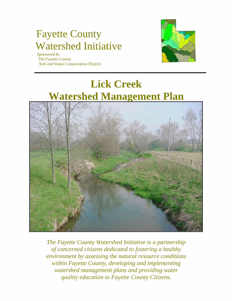
Fayette County Watershed Initiative Sponsored by The Fayette County Soil and Water Conservation District Lick Creek Watershed Management Plan The Fayette County Watershed Initiative is a partnership of concerned citizens dedicated to fostering a healthy environment by assessing the natural resource conditions within Fayette County, developing and implementing watershed management plans and providing water quality education to Fayette County Citizens.
Transcript of Fayette County Watershed Initiative - IN.gov · Fayette County Watershed Initiative Sponsored by...
Fayette County Watershed Initiative Sponsored by The Fayette County Soil and Water Conservation District
Lick Creek Watershed Management Plan
The Fayette County Watershed Initiative is a partnership of concerned citizens dedicated to fostering a healthy
environment by assessing the natural resource conditions within Fayette County, developing and implementing watershed management plans and providing water
quality education to Fayette County Citizens.

_________________ Lick Creek Watershed Management Plan_______________
2
_________________ Lick Creek Watershed Management Plan_______________
Acknowledgements
The Fayette County Soil and Water Conservation District would like to thank the following individuals and entities
who contributed valuable time to making the Fayette County Watershed Initiative a success:
Cindy Bernzott Gary Breitenbach
Ed Herrell Cindy Bernzott Bill MacDaniel
Matt Sherck Darrell Smith
Brad Starr Nicole Viars
Joe Waggener Jayson Waterman
Connersville Wastewater Treatment Plant Staff Area Plan Commission
Community Education Coalition Connersville News Examiner
Fayette County Health Department Natural Resources Conservation Service
Fayette County Farm Bureau Earlham College
3
_________________ Lick Creek Watershed Management Plan_______________
Individuals interested in obtaining additional information regarding the Fayette County Watershed Initiative may contact the following:
• Fayette County Soil and Water Conservation District 2590 North Park Road Connersville, IN 47331 765-825-2331
• Community Education Coalition
3013 Virginia Avenue Connersville, IN 47331 765-825-7633
4
_________________ Lick Creek Watershed Management Plan_______________
Table of Contents I. Introduction .............................................................................................7 II. Planning Process ........................................................................... ... 21 III. Water Quality in the Lick Creek Watershed ..................................25 IV. Water Quality Education in the Lick Creek Watershed................49 V. Forest Management in the Lick Creek Watershed ..........................59 VI. Agricultural Management in the Lick Creek Watershed ..............75 VII. Septic Systems in the Lick Creek Watershed ..............................109 VIII. Local Government and Watershed Planning ............................117 IX. Plan Implementation........................................................................123 Literature Cited ......................................................................................151 Appendix..................................................................................................153
5

_________________ Lick Creek Watershed Management Plan_______________
This page intentionally left blank
6
_________________ Lick Creek Watershed Management Plan_______________
I. Introduction In the Fall of 2000, the Fayette County Soil and Water Conservation District (FCSWCD), submitted a Section 319 Grant Application to the Indiana Department of Environmental Management (IDEM) to implement a 2-year public input process and develop a watershed management plan for the Lick Creek watershed. Section 319 of the Federal Clean Water Act provides funding for various types of projects that work to reduce nonpoint source (NPS) water pollution. A two-year grant in the sum of $89,000 was awarded to the FCSWCD from the US Environmental Protection Agency (EPA) and the Indiana Department of Environmental Management (IDEM). The grant period was from June 2, 2001 through September 1, 2003. The Section 319 grant included the following requirements:
1. Hire a Watershed Coordinator, 2. Organize a local Steering Committee (SC) 3. Evaluate the water quality conditions of the Lick Creek Watershed 4. Develop a watershed management plan that meets the requirements of
the IDEM’s checklist titled, “What Needs to be in a Watershed Management Plan Checklist.”
The FCSWCD Board of Supervisors chose to hire contract personnel to serve the role of “watershed coordinator.” The FCSWCD entered into a sub-contractual agreement with a professional environmental staffing company, Goode & Associates, Inc., whose specialty is water quality management, policy analysis, and watershed coordination. This subcontract allowed for twenty-one (21) months of coordination, meeting facilitation, water quality field sampling, map preparation, and various related coordination and management services. Goode & Associates, Inc. provided a “watershed coordination team” (referred to throughout this document) consisting of a land use planner, a biologist/water quality chemist, an agricultural specialist, a local government policy and regulatory specialist, and a Geographical Information Systems (GIS) mapping and database specialist. The lead representative from the watershed coordination team is referred to throughout this document as the “watershed coordinator.” The watershed coordination team drafted the Lick Creek Watershed Management Plan, which meets the checklist requirements of the “What Needs to be in a Watershed Management Plan” FFY 2003. What is Watershed Management and Planning? Traditionally, water quality management focused solely on individual wastewater discharges from municipal and industrial facilities. These wastewater discharges are classified as “point” sources of pollution (PS). However, watershed planning and management take a broad, holistic approach to water quality issues by focusing on all potential sources of pollution with an emphasis on polluted runoff or
7
_________________ Lick Creek Watershed Management Plan_______________
nonpoint pollution sources. Funds for this grant are limited to nonpoint source pollution (NPS). NPS pollution stems from a variety of sources and is often the largest source of water pollution in watersheds. NPS pollution occurs when rain, snowmelt, or other sources of water runs off the landscape while picking up and carrying pollutants to nearby streams, rivers, lakes, and groundwater supplies. The level of NPS pollution carried to waterways is directly related to the land use and land management practices occurring within a given watershed. Watershed management involves a wide variety of activities, including: the identification and assessment of land use and land management practices, the identification of priority areas and problems, promoting the involvement of interested and affected stakeholders, and developing and implementing strategies to address NPS pollution sources. Watershed management is being widely adopted across the United States and is heavily endorsed by the Environmental Protection Agency (EPA) and other public and private organizations concerned with water quality. In fact, by developing watershed management plans, targeted areas become eligible for funding to implement a wide array of water quality related projects. Funding sources include, but are not limited to, the Indiana Department of Environmental Management, the Environmental Protection Agency, the Indiana Department of Natural Resources, and the United States Department of Agriculture. Watershed Maps & Location The Lick Creek watershed is 1 of 32 14-digit hydrologic unit code (HUC) watersheds located in the Whitewater River Basin in East Central Indiana (HUC 0508000304020) (Figure 1-1). The United States is divided and sub-divided into successively smaller hydrologic units, which are classified into four levels: regions, sub-regions, accounting units, and cataloging units. The hydrologic units are arranged within each other, from the smallest (cataloging units) to the largest (regions). Each hydrologic unit is identified by a unique hydrologic unit code (HUC) consisting of two to eight digits based on the four levels of classification in the hydrologic unit system (USGS, 2003). A HUC is simply the address of a particular watershed. Description and History of the Lick Creek Watershed The following is an overview of the physical and cultural characteristics of the Lick Creek Watershed. Climate Fayette County has a continental type of climate. There are erratic changes of temperature within and between the seasons. The winters are moderately cold and the summers are fairly hot and humid. Fayette County has an average frost
8
_________________ Lick Creek Watershed Management Plan_______________
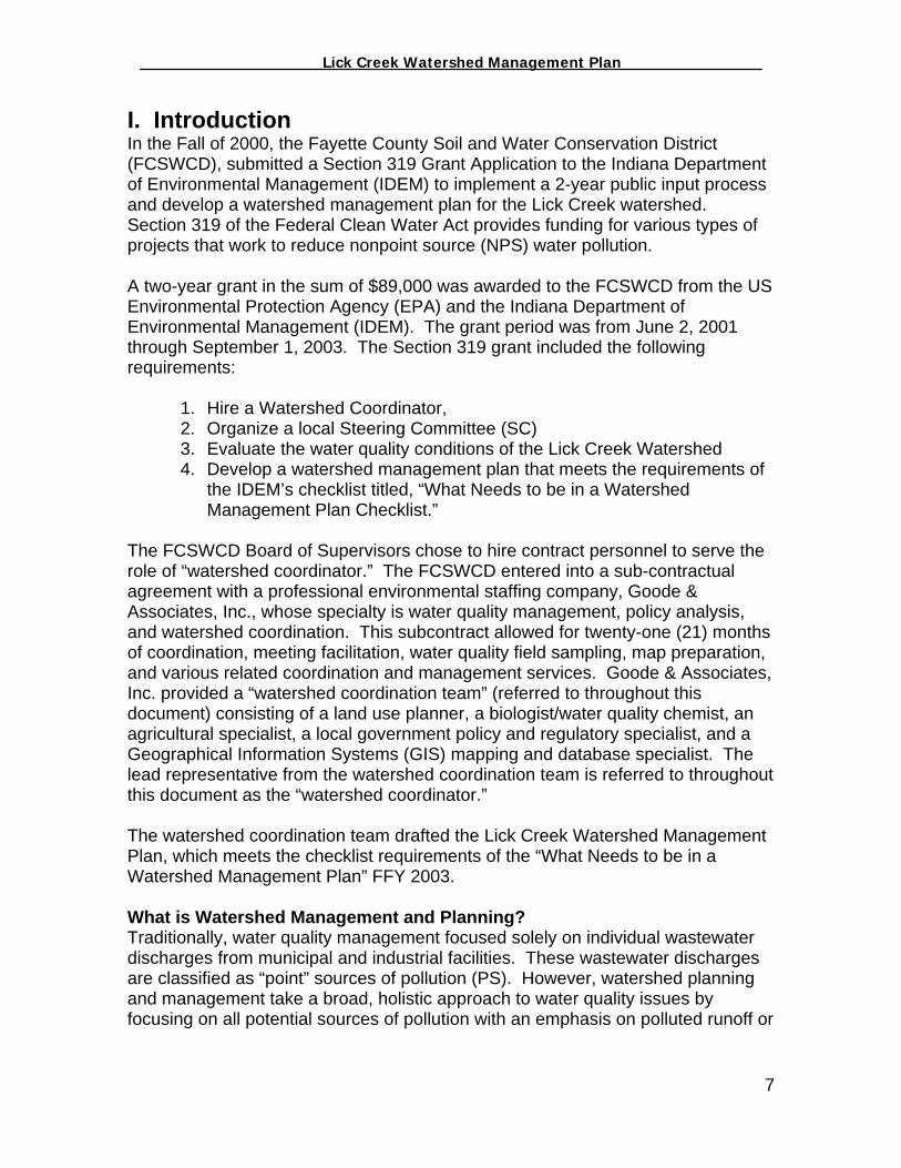
free period of 155 days with the average date of the last killing frost on May 3rd and an average date of the first frost on October 5th. Rainfall is fairly uniform throughout the year, but it does vary from season to season. The heaviest rains typically arrive in the spring, which may cause erosion of upland soils and flooding in the lowlands. As a result, floods are a constant threat to crops on the bottomlands of the Whitewater River and many of its tributaries, including Lick Creek. In some areas crops are frequently damaged by a lack of moisture during July and August, which are typically the regions hottest months. Figure 1-1: Lick Creek Watershed and the Whitewater Basin
9

_________________ Lick Creek Watershed Management Plan_______________
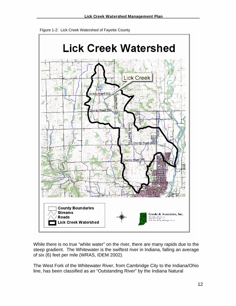
Most of the snowfall takes place during the period from December through March, but the average annual snowfall is limited. The winter season is well known for its rapid changes in temperatures. Sub-freezing temperatures last for an average of 2 to 3 days and are typically followed by short periods of warmer weather. The resulting freezing and thawing effects sometimes cause heaving of the soil and winter-killing of such crops as alfalfa, clover, and winter wheat. Geography Fayette County encompasses approximately 215 square miles of land and is located approximately 55 miles east southeast of Indianapolis. The county is bordered by Henry and Wayne Counties on the north, Union County on the east, Franklin County on the south, and Rush County on the west. The Lick Creek Watershed consists of 9,549 acres and lies primarily within Fayette County in East Central Indiana with a small portion of the watershed extending into Wayne County (Figure 1-2). The Lick Creek watershed encompasses 9,549 acres within Fayette County and 640 acres within Wayne County (Table 1-1). There are approximately twelve (12) miles of perennial streams within the Lick Creek watershed and an undetermined, yet significant, length of drainage ditches, all of which eventually drain to the West Fork Whitewater River. Table 1-1: Lick Creek Watershed Acres by County
County Acres % of Watershed
Fayette 8,909 93 Wayne 640 7
The Lick Creek watershed lies within Posey and Harrison Townships in north central Fayette County. The Lick Creek watershed is predominately rural but does include commercial, industrial and residential areas within a small portion of the city of Connersville, Indiana. Hydrology Lick Creek is a small headwater stream that drains the north central portion of Fayette County and a small portion of Wayne County into the West Fork Whitewater River. Lick Creek originates from the spillway of Manlove Park Lake, a 15-acre lake owned by the Fayette County Park Board that is operated and maintained by the Fayette County Conservation Club. On its journey, Lick Creek flows through vast acres of agricultural lands then through an industrialized and residential portion of Connersville before entering the Whitewater River. Lick Creek is not on the state’s 303d list. Section 303(d) of the Clean Water Act requires states to identify waters that do not or are not expected to meet applicable water quality standards with federal technology based standards alone. States are also required to develop a priority ranking for these waters taking into account the severity of the pollution and the designated uses of the waters. Once this listing and ranking of waters is completed, the states are required to develop
10
_________________ Lick Creek Watershed Management Plan_______________
Total Maximum Daily Loads (TMDLs) for these waters in order to achieve compliance with the water quality standards. Indiana's 303(d) list was approved by EPA on February Five municipal wellheads are located within Roberts Park near the confluence of Lick Creek and the Whitewater River. These wellheads provide drinking water to thousands of Connersville citizens. The Whitewater River rises in Indiana in southern Randolph and Wayne Counties and flows in two main branches, the East Fork and West Fork, which are just 10 miles apart as they flow southward before joining at Brookville. From the Brookville Reservoir, the Whitewater flows southeasterly into Ohio where it eventually joins the Miami River, a tributary of the Ohio River.
11
_________________ Lick Creek Watershed Management Plan_______________
Figure 1-2: Lick Creek Watershed of Fayette County
While there is no true “white water” on the river, there are many rapids due to the steep gradient. The Whitewater is the swiftest river in Indiana, falling an average of six (6) feet per mile (WRAS, IDEM 2002). The West Fork of the Whitewater River, from Cambridge City to the Indiana/Ohio line, has been classified as an “Outstanding River” by the Indiana Natural
12

_________________ Lick Creek Watershed Management Plan_______________
Resources Commission (NRC). This stretch of the River extends from Fayette County through Franklin County and into Dearborn County before it reaches the Indiana-Ohio line. In 1993, the Indiana Natural Resources Commission (NRC) adopted its "Outstanding Rivers" List for Indiana. This listing is referenced in the standards for utility line crossings within floodways, formerly governed by IC 14-28-2 and now controlled by 310 IAC 6-1-16 through 310 IAC 6-1-18. Except where incorporated into a statute or rule, the "Outstanding Rivers List" is intended to provide guidance rather than to have regulatory application (NRC 1997). To help identify the rivers and streams that have particular environmental or aesthetic interest, a special listing has been prepared by IDNR's Division of Outdoor Recreation. This listing is a corrected and condensed version of a list compiled by American Rivers and dated October 1990 (NRC, 2003). Geology The bedrock strata in Fayette County are comprised of predominately limestones, shales, sandstones, and dolomites that stem from Ordovician to the Silurian periods. Silurian limestones and dolomites, with some shales, are found in most of the western third of the county (Soil and Water Survey, 1967). The Illinoian drift is composed mostly of till, largely clay which is generally hard and compact, with small areas of sand and gravels in thin beds. The thickness of the Illinoian drift in the Lick Creek watershed ranges from less than 50 to over 100 feet (Soil and Water Survey, 1967). The Wisconsin drift includes ground moraine, end moraine, and ice-contact stratified drift. These moraines constitute over one-half of the surface area of Fayette County and are composed mostly of till, with small areas of ice-contact stratified drift and lake sediments. The till is composed principally of clay, sand and gravelly clay, boulderly clay, and sand and gravel. The thickness of the Wisconsin drift varies from less than 50 feet in several areas to over 300 feet (Soil and Water Survey, 1967). The Upper Pleistocene undifferentiated deposits cover the West Fork of Whitewater River Valley. These deposits consist of outwash plain sediments, mainly Wisconsin outwash composed of clay, sandy clay, gravelly clay, boulderly clay, clayey sand and gravel, and sand and gravel. The thickness of these deposits increases from less than 100 feet to 200 feet (Soil and Water Survey, 1967).
13
_________________ Lick Creek Watershed Management Plan_______________
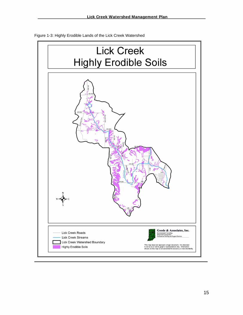
Physiography The Lick Creek watershed lays predominately in the southern edge of the Tipton till plain. The Tipton till plain is extremely flat and most of the glacial moraines that cross the plain have gentle slopes (Soil and Water Survey, 1967). Soils The soils of Fayette County and the Lick Creek watershed have been developed from glacial materials. The United States Soil Conservation Service (SCS), now known as the Natural Resources Conservation Service (NRCS), in cooperation with the Purdue University, classified Fayette County soils into 12 types which are grouped into seven classes and three general categories. The three general categories are as follows: Class I Soils of the flood plains Class II Soils of the river and terraces and former glacial channels Class III-VII Soils of the Uplands All classes of soils (I-VII) are found within the Lick Creek watershed. In general, the upland soils (Classes III-VII) present fewer problems to residential and commercial development than do the soils of the flood plains (Class I), but more problems than do the soils of the river terraces and former glacial channels (Class II). The suitability of most of the upland soils as sources of topsoil is good and their suitability for foundations for buildings is fair to good. However, the upland soils are not suitable as sources of sand and gravel, their suitability for road sub-grade is fair to poor, and most of them have moderate to severe limitations for septic systems and a moderate to high corrosion potential for metal conduit (Soil and Water Survey, 1967). Highly Erodible Lands (HEL) The Natural Resources Conservation Service (NRCS) uses the soil erodibility index (EI) to provide a numerical expression of the potential for a soil to erode considering the physical and chemical properties of the soil and the climatic conditions where it is located. As a result, the basis for identifying highly erodible land is the erodibility index of a soil map unit. The erodibility index of a soil is determined by dividing the potential erodibility for each soil by the soil loss tolerance (T) value established for the soil. The T value represents the maximum “tolerable” annual rate of soil erosion that could take place without causing a decline in long-term productivity. Figure 1-3 identifies those areas of the watershed that are considered to be highly erodible by the 1960 Fayette County Soil Survey. Approximately 14% or 1,360 acres within the watershed fit the HEL classification.
14
_________________ Lick Creek Watershed Management Plan_______________
Figure 1-3: Highly Erodible Lands of the Lick Creek Watershed
15
_________________ Lick Creek Watershed Management Plan_______________
Wildlife in the Lick Creek Watershed Fayette County has many of the same wildlife species that exist in the rest of Indiana. For example, deer, rabbit, hawks, owl, raccoon, opossums, coyotes, foxes, and songbirds (such as the American Robin, Starlings, Blackbirds, Flycatchers, etc.) exist in Fayette County in prevalence. In addition, game species such as bobwhite quail, wild turkey, and some ruffed grouse also exist in Fayette County (IDNR District Biologist, 2003). Additionally, there are resident populations of Canada Geese and species of ducks including Mallard, Blue-Winged Teal, Scaup, Redhead and Widgeon that migrate through the area as well as Osprey, Sandhill Crane, Woodcocks, several species of hawks and even an occasional bald eagle. All of these species exist as part of a diverse landscape and habitat model in Fayette County. Fayette County is a fairly rural part of the state and as such lends itself to the propagation of the aforementioned species (IDNR District Biologist, 2003). Endangered and Threatened Species of Fayette County There are a number of endangered, threatened, and rare plants and animals that have been identified in Fayette County (Table 1-2). However, the FCWI did not conduct a detailed study to verify that these plants and animals are located in the Lick Creek watershed. Table 1-2: Endangered and Threatened Species per IDNR Wildlife Biologist
Species Name Common Name State Listing Federal Listing
Carex Sparganioides Var cephaloidea Thinleaf Sedge Threatened Not Listed Juglans cinerea Butternut Watch List Not Listed Poa paludigena Bog Bluegrass Watch List Not Listed Utricularia cornuta Horned
Bladderwort Threatened Not Listed
Plethodon richmondi Ravine Salamander Not Listed Not Listed Aimophila aestivalis Bachman’s
Sparrow Endangered Not Listed
Botaurus lentiginosus American Bittern Endangered Not Listed Dendroica cerulea Cerulean Warbler Special
Concern Not Listed
Vermivora chrysoptera Golden-Winged Warbler
Endangered Not Listed
Lynx rufus Bobcat Endangered Not Listed Mustela nivalis Least Weasel Special
Concern Not Listed
Nycticeius humeralis Evening Bat Endangered Not Listed Taxidea taxus American Badger Endangered Not Listed
16
_________________ Lick Creek Watershed Management Plan_______________
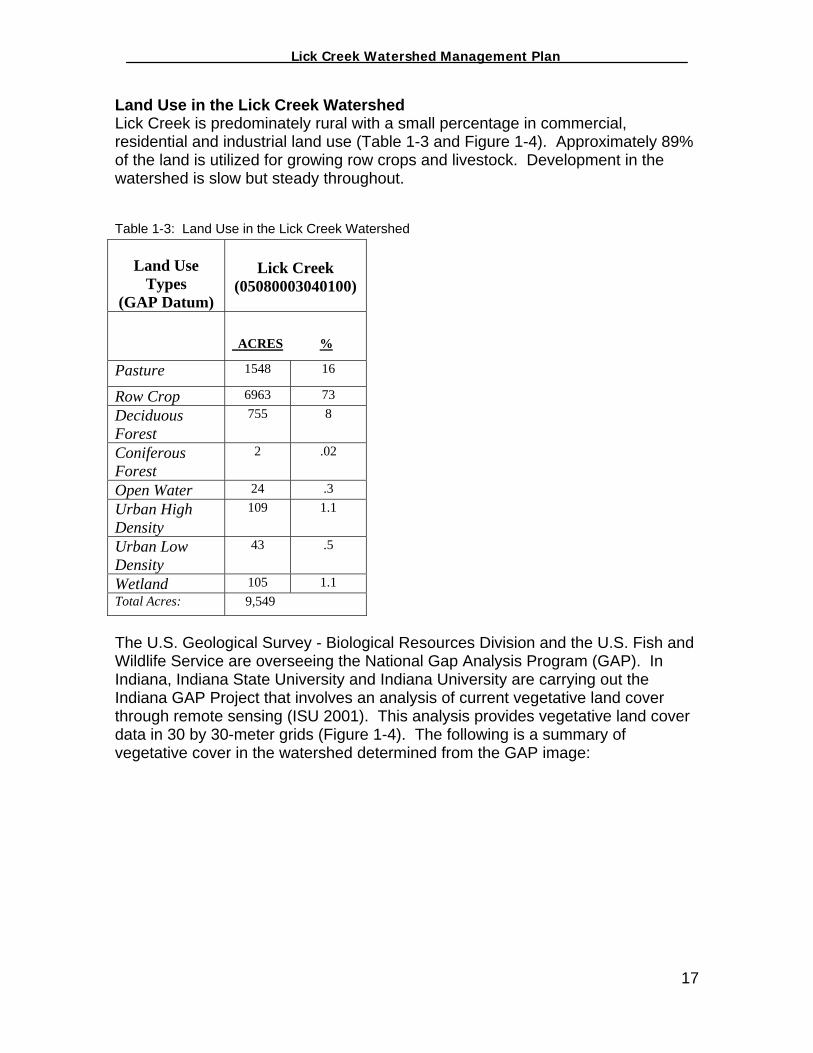
Land Use in the Lick Creek Watershed Lick Creek is predominately rural with a small percentage in commercial, residential and industrial land use (Table 1-3 and Figure 1-4). Approximately 89% of the land is utilized for growing row crops and livestock. Development in the watershed is slow but steady throughout. Table 1-3: Land Use in the Lick Creek Watershed
Land Use Types
(GAP Datum)
Lick Creek
(05080003040100)
ACRES %
Pasture 1548 16
Row Crop 6963 73 Deciduous Forest
755 8
Coniferous Forest
2 .02
Open Water 24 .3 Urban High Density
109 1.1
Urban Low Density
43 .5
Wetland 105 1.1 Total Acres: 9,549
The U.S. Geological Survey - Biological Resources Division and the U.S. Fish and Wildlife Service are overseeing the National Gap Analysis Program (GAP). In Indiana, Indiana State University and Indiana University are carrying out the Indiana GAP Project that involves an analysis of current vegetative land cover through remote sensing (ISU 2001). This analysis provides vegetative land cover data in 30 by 30-meter grids (Figure 1-4). The following is a summary of vegetative cover in the watershed determined from the GAP image:
17

_________________ Lick Creek Watershed Management Plan_______________
Figure 1-4: Land Use in the Lick Creek Watershed
18
_________________ Lick Creek Watershed Management Plan_______________
The majority of the forests within Fayette County are located in the southern half of the county in Orange, Columbia, and Jackson Townships. The Lick Creek watershed, located in Harrison and Posey Townships contains only 757 acres of forest. However, according to Jayson Waterman, IDNR District Forester, there are quality forests in the Lick Creek watershed. The agricultural lands in the watershed are vast and involve primarily corn, soybean, wheat, hay and cattle production. The majority of land in the Lick Creek watershed is privately owned. The two exceptions are Manlove Park, which is owned by the Fayette County Park Board, and Roberts Park, which is operated and maintained by the Connersville Park Department. The commercial and industrial portions of the Lick Creek watershed are found predominately along the SR 1 corridor in Connersville, Indiana. The residential portions of the watershed are limited to the northeast portion of Connersville and also throughout the rural portions of the watershed. Cultural History of Fayette County Fayette County is part of an area originally claimed by the Miami Confederacy of Indiana. In 1795, the Greenville Treaty Line cut through the area and in 1803, the land to the east of the line was ceded to the United States under terms of the Old Boundary Line Treaty. The area west of the line was ceded to the United States as part of the 12-mile Purchase under terms of a treaty signed at Fort Wayne in 1811 (Chamber of Commerce, 2003). John Conner, one of the signers of the purchase document, was the first settler in Fayette County. In 1809, Conner opened a trading post along the Whitewater River in an area that later came to be known as Connersville. Conner’s trading post attracted more and more settlers who cleared the woodlands of the area to cultivate crops for food. Those settlers that opted not to farm the lands opened trading posts or began to operate gristmills, sawmills, or tanneries. In 1817, with a population of 3,000, the county was officially recognized by the State of Indiana and was named in honor of General Lafayette (Chamber of Commerce, 2003). The only roads the earlier settlers had were old Indian trails through the forest. The rivers and streams were crossed at shallow fords and the livestock had to be driven to market on foot. An attempt was made to provide transportation by canal, and the first canal boat arrived at Connersville in 1845. The canal provided a means of shipping products such as flour, eggs, apples, bacon, cracklings, lard, and hob bristles. The boats on the canal were pulled by mules or horses along a path called the towpath. Severe floods, however, destroyed much of the canal, and little use was made of it. The canal was soon after sold at a heavy loss to the Whitewater Railroad for a right-of-way. The Whitewater Canal eventually succumbed to the railroad. In 1863 a railroad company purchased the local canal company and laid tracks along the towpath. The railroad was responsible for
19
_________________ Lick Creek Watershed Management Plan_______________
catapulting Connersville and Fayette County into the 20th Century as a center of industrial production (Chamber of Commerce, 2003). Connersville quickly became known as a “furniture and buggy town” due to the many factories involved in the production of these items. However, once the automobile or horseless carriage was invented, the buggy and wagon were pushed aside. The different automobiles produced in Connersville include: the Lexington, the McFarland, the Cord, the Auburn, and the Empire (Chamber of Commerce, 2003). In 1909, The McFarland Carriage Company manufactured the first medium-priced 6-cylinder automobile, the Lexington, in the United States. Not only did Connersville and its people produce the automobiles themselves, they also made nearly all the parts necessary to build a complete automobile. This earned Connersville the title of “Little Detroit” (Chamber of Commerce, 2003). The industries in Connersville quickly became the major employers. Among the articles manufactured were automobile parts, dishwashers kitchen cabinets, refrigerators, heating equipment, caskets and burial vaults, tools, diesel lain tanks and casings, and feed for livestock (Chamber of Commerce, 2003).
20

_________________ Lick Creek Watershed Management Plan_______________
II. Watershed Planning Process The two-year Section 319 Grant was awarded to the FCSWCD in September of 2001. Actual watershed planning efforts, however, did not begin until January of 2002 when the FCSWCD contracted with Goode & Associates, Inc., a professional watershed coordination team, to manage the project. The lead representative from Goode & Associates, Inc. became known as the watershed coordinator and is referred to hereafter by that title. In January 2002, the FCSWCD and the watershed coordinator hosted the first public meeting at the Connersville High School to discuss the details of the Section 319 Grant, the concept of watershed planning and, most importantly, to solicit input and participation from the public. Unfortunately, the meeting was not well attended due to a winter storm advisory. There were, however, six (6) individuals in attendance. As a result of the meeting, three individuals volunteered to participate by serving on the Steering Committee. The watershed coordinator then initiated a search for the remaining necessary Steering Committee members. Based upon recommendations from a variety of individuals, Steering Committee “candidates” were contacted via telephone, e-mail, or through face-to-face interactions and invited to attend a meeting at Roberts Park on February 6, 2002. The meeting involved a presentation given by the watershed coordinator to discuss the grant, the concept of watershed planning and the importance and necessity of having a group of individuals from the community to serve as Steering Committee members to guide the development of the watershed plan. The meeting was well attended and the majority of those in attendance agreed to participate in the process. Table 2-1 identifies the Steering Committee members who volunteered numerous hours of their personal and professional time to guide this project. The Steering Committee officially gathered for the first time in February 2001 and opted to recognize their efforts as the Fayette County Watershed Initiative (FCWI). Table 2-1: FCWI Steering Committee Members Steering Committee Representing Cindy Bernzott Community Education Coalition (CEC) Gary Breitenbach Community Stakeholder/Earlham College Ed Herrell Community Education Coalition (CEC) Bill MacDaniel Area Plan Commission (APC) Matt Sherck Fayette County Health Department (FCHD) Darrell Smith Connersville News Examiner Nicole Viars Natural Resources Conservation Service (NRCS) Joe Waggener Community Stakeholder Jayson Waterman District Forester- Indiana Department of Natural Resources
21
_________________ Lick Creek Watershed Management Plan_______________
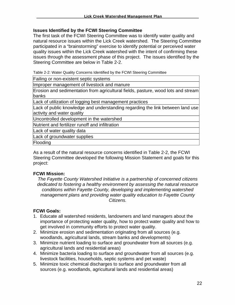
Issues Identified by the FCWI Steering Committee The first task of the FCWI Steering Committee was to identify water quality and natural resource issues within the Lick Creek watershed. The Steering Committee participated in a “brainstorming” exercise to identify potential or perceived water quality issues within the Lick Creek watershed with the intent of confirming these issues through the assessment phase of this project. The issues identified by the Steering Committee are below in Table 2-2. Table 2-2: Water Quality Concerns Identified by the FCWI Steering Committee
Failing or non-existent septic systems Improper management of livestock and manure Erosion and sedimentation from agricultural fields, pasture, wood lots and stream banks Lack of utilization of logging best management practices Lack of public knowledge and understanding regarding the link between land use activity and water quality Uncontrolled development in the watershed Nutrient and fertilizer runoff and infiltration Lack of water quality data Lack of groundwater supplies Flooding
As a result of the natural resource concerns identified in Table 2-2, the FCWI Steering Committee developed the following Mission Statement and goals for this project: FCWI Mission:
The Fayette County Watershed Initiative is a partnership of concerned citizens dedicated to fostering a healthy environment by assessing the natural resource
conditions within Fayette County, developing and implementing watershed management plans and providing water quality education to Fayette County
Citizens. FCWI Goals: 1. Educate all watershed residents, landowners and land managers about the
importance of protecting water quality, how to protect water quality and how to get involved in community efforts to protect water quality.
2. Minimize erosion and sedimentation originating from all sources (e.g. woodlands, agricultural lands, stream banks and developments)
3. Minimize nutrient loading to surface and groundwater from all sources (e.g. agricultural lands and residential areas)
4. Minimize bacteria loading to surface and groundwater from all sources (e.g. livestock facilities, households, septic systems and pet waste)
5. Minimize toxic chemical discharges to surface and groundwater from all sources (e.g. woodlands, agricultural lands and residential areas)
22
_________________ Lick Creek Watershed Management Plan_______________
The Planning Process Recognizing that time was an issue considering the vast amounts of information necessary to create this plan, the Steering Committee opted to address water quality issues through a systematic process. Based upon the issues identified in Table 1-2, the different land uses in the watershed, the different audiences that exist in the watershed (farmers, forest owners, residents and governmental agencies) and the different mechanisms necessary to address water quality issues (local ordinances, state laws, state and federal programs, etc.) the Steering Committee opted to segment the process into the following subjects:
1. Water Quality 2. Public Water Quality Education in the Lick Creek Watershed 3. Forestry in the Lick Creek Watershed 4. Agriculture in the Lick Creek Watershed 5. Septic Systems in the Lick Creek Watershed 6. Other Residential Issues in the Lick Creek Watershed 7. Local Government and Watershed Management
Realizing that the above subjects had the most influence on the water quality conditions of the Lick Creek watershed, the Steering Committee, with the assistance of the watershed coordinator, investigated and assessed each of these topics, developed strategies based on their findings, and identified resources and funds to implement those strategies. The remainder of this plan is divided among the seven (7) subjects identified above. The individual sections highlight the current conditions of the resources within the watershed, the different land use practices in the watershed, and the different strategies the Steering Committee devised to address the conditions and land use practices in the watershed. The FCWI Steering Committee felt that by dividing this plan into different subject matters, the plan would be more “user friendly” to the common reader. Partnerships Numerous partnerships evolved through the efforts of the FCWI. The different partners played varying roles from providing technical assistance, attending and participating in Steering Committee meetings, writing letters of recommendations for grant applications, etc. Below is a list of the different entities involved in developing this watershed plan:
Individuals/Stakeholders from the Lick Creek watershed Fayette County Soil and Water Conservation District (FCSWCD) Natural Resources Conservation Service (NRCS) Community Education Coalition (CEC) Indiana Department of Environmental Management (IDEM) Indiana Department of Natural Resources (IDNR) Fayette County Health Department (FCHD) Connersville Wastewater Treatment Plant
23

_________________ Lick Creek Watershed Management Plan_______________
Area Plan Commission (APC) Connersville News Examiner Earlham College, Biology Department IU East, Natural Science and Math Division Three Rivers Solid Waste Management District (SWMD) Fayette County Farm Bureau
Public Participation In order to encourage participation by additional stakeholders, the watershed coordinator developed and submitted press releases to the Connersville News Examiner announcing all FCWI meetings as being open to the public. The Steering Committee met the third Wednesday of each month at 4pm in the Area Plan Commission at the Fayette County Annex. Additional newspaper articles highlighting the FCWI were also published throughout the project. A series of eight newsletters were developed highlighting this project and urging public participation. Newsletters were placed at the local library, the FCSWCD office, and the Community Education Coalition office and at the annual Fayette County Free Fair. The FCWI was also highlighted in the quarterly FCSWCD newsletter that was mailed to over 300 residents within Fayette County. A survey was conducted during the 2002 Fayette County Free Fair to help the Steering Committee identify the level of water quality understanding on behalf of Fayette County citizens. The findings of the survey helped the Steering Committee prioritize their efforts. A public meeting was held at the beginning and at the end of the planning phase of this project to encourage public participation and public input into the draft document of this plan. A presentation regarding this project was also conducted at Manlove Park to members of the Fayette County Conservation Club.
24
_________________ Lick Creek Watershed Management Plan_______________
III. Lick Creek Water Quality Assessment In an effort to establish baseline water quality data and to determine if the efforts of the FCWI were that of restoration or protection, the watershed coordination team conducted physical, chemical and biological monitoring within the Lick Creek watershed. The data collected was used to assist in identifying broad, watershed-wide water quality issues and for developing the watershed management strategies discussed throughout the remainder of this document. Water quality monitoring activities were conducted in accordance to the Quality Assurance Project Plan (QAPP) which was developed prior to the initiation of monitoring activities. The QAPP is on file with the IDEM Watershed Management Section. Monitoring Objectives Data collected by the study was compared to concentration based water quality standards to identify “hot spots” or priority areas in the watershed where water quality standards are not being met. In addition, the data collected during this study serves as “baseline data” to track changes in conditions of the watershed and may be used in the future to track the success of any watershed management efforts undertaken as a result of this watershed management plan. To achieve the goal of evaluating and ranking “hot spots” in the watershed relative to one another and assisting the prioritization of management efforts, emphasis was placed on maintaining standard procedures at each water quality sampling site. Consistencies in protocol were used to ensure that sampling sites could be compared to one another, enabling the watershed coordination team to determine which sites are most degraded relative to others in the watershed. Study Area Preliminary sites for monitoring were selected utilizing a road map and then field checked by the watershed coordination team for verification of site accessibility. Following the field inspection, four (4) sampling sites were selected within the Lick Creek watershed. The locations of these sites are shown in Figure 3-1 and Table 3-1 provides additional site details. Water quality parameters sampled at each site include pH, E. coli, nitrogen, ammonia, biological oxygen demand (BOD), and total suspended solids (TSS). The Connersville Waste Water Treatment Plant analyzed the samples for these parameters at their laboratory at no charge. Surface water temperature was measured in the field using a standard stream thermometer.
25

_________________ Lick Creek Watershed Management Plan_______________
Figure 3-1 Lick Creek Monitoring Sites
26

_________________ Lick Creek Watershed Management Plan_______________
Table 3-1: Lick Creek Watershed Monitoring Site Descriptions Site Identification #: Waterbody Name Location
Site 1 Lick Creek CR 250W & CR 500N Site 2 Lick Creek CR 300N & Elephant Hill Rd. Site 3 Lick Creek CR 300W, .5 miles west of SR1 Site 4 Lick Creek Waterloo Rd.
Sampling Design and Project Timetable The above-mentioned, chemical parameters were monitored a total of six (6) times: during 3 wet weather sampling events and 3 dry weather sampling events. Water chemistry data was collected during the project period (Table 3-2). Collection of water quality data provided an overview of the water quality conditions in the watershed under varying conditions. Macroinvertebrate bio-assessments were conducted on a bi-annual basis beginning in May 2002 (Table 3-2). This timing allowed the data to be consistent with standard bio-assessment protocols. A subsequent habitat analysis was conducted during each bio-assessment. Table 3-2. Parameters to be Studied and Project Schedule
Type of Sample/ Parameter Sampling Event Frequency Sampling
Period
Chemical Water Quality • 3 Dry Weather Events & • 3 Wet Weather Events
Summer 2002 thru
Summer 2003
Biological Macroinvertebrates and CQHEI
• Biannual Macroinvertebrate • Biannual CQHEI
Summer 2002 thru
Summer 2003
Water Quality Sampling The watershed coordination team collected samples for all of the chemical water quality parameters. Samples were taken using grab sampling protocols as outlined in Standard Methods for the Examination of Water and Wastewater, 19th Edition. Samples were delivered to the Connersville WWTP lab within 6 hours in order to meet sample-holding times outlined in the Connersville WWTP’s sampling procedures. Sample bottles were labeled by date and sampling location. Water quality samples were processed at the Connersville WWTP lab using standard operating protocols. Biological Sampling The watershed coordination team collected macroinvertebrate samples from the Lick Creek watershed utilizing the Hoosier Riverwatch Kick Seine method. Once collected, each sample was spread onto a grid and randomly selected grids were completely picked until a 100-organism sub-sample was obtained. In the event 100-organisms did not result, the sample was sorted through for one hour and those organisms collected were identified and counted. Macroinvertebrates were
27

_________________ Lick Creek Watershed Management Plan_______________
identified to the Order and Family level where possible. The data was analyzed using Riverwatch identification and scoring methods. Benthic macroinvertebrates are animals that are big enough (macro) to be seen with the naked eye. They lack backbones (invertebrates) and live in or on the bottom (benthos) of a body of water (Hoosier Riverwatch, 2002). Macroinvertebrates include aquatic insects such as mayflies, stoneflies, caddisflies, midges, beetles, snails, worms, freshwater clams, mussels, and crayfish. Some benthic macroinvertabrates, such as midges, are small and grow no larger than ½ inch in length. Others, like the three ridge mussel, can be over ten inches long (Hoosier Riverwatch, 2003).
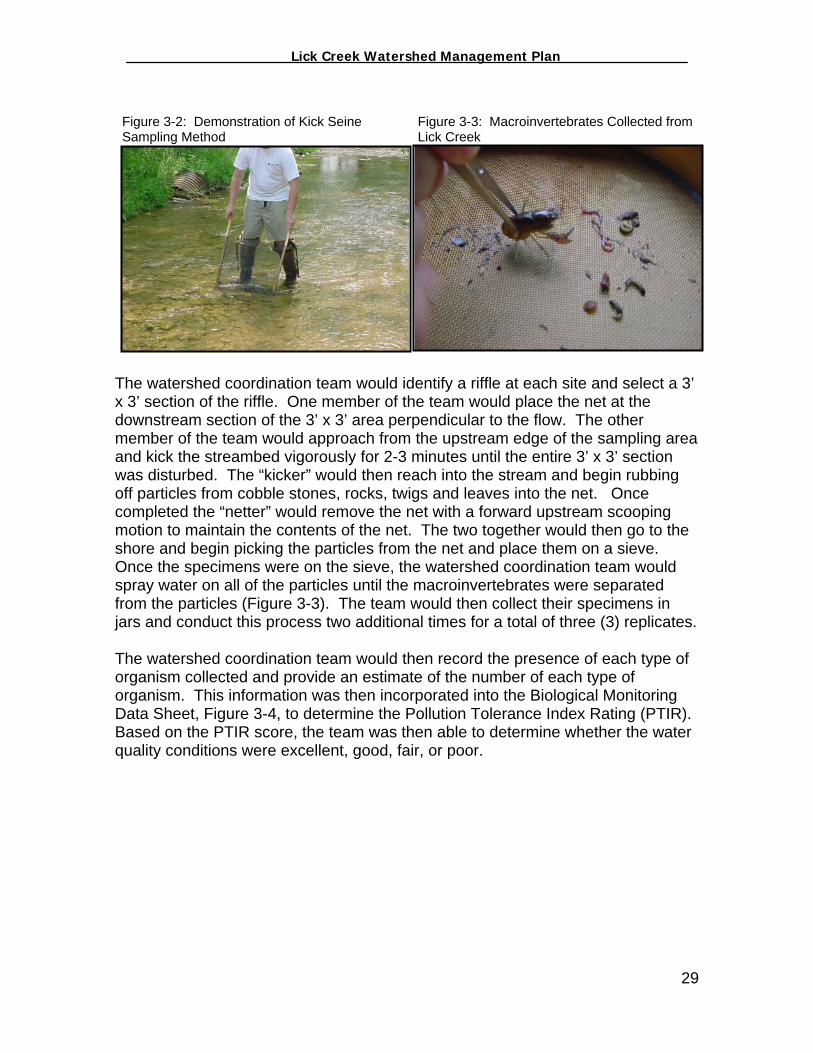
Stone Fly Caddis Fly Larvae Riffle Beetle Right Handed Snail Source: IDNR Biological monitoring focuses on the aquatic organisms that live in streams and rivers. Scientists observe changes that occur in the number of types of organisms present in a stream system to determine the richness of the biological community. Scientists also observe the total number of organisms in an area, or the density of the biological populations present. If community richness and community density change over time, it may indicate the effects of human activity on the stream. Biological stream monitoring is based on the fact that different species react to pollution in different ways. Pollution-sensitive organisms such as mayflies, stoneflies, and caddisflies are more susceptible to the effects of physical or chemical changes in a stream than other organisms. These organisms act as indicators of the absence of pollutants. Pollution-tolerant organisms, such as midges and worms are less susceptible to changes in physical and chemical parameters in a stream and are more indicative of a presence of pollutants (Hoosier Riverwatch, 2003). Macroinvertebrate Sampling Procedures-Kick The watershed coordination team conducted macroinvertebrate sampling using a Kick Seine twice at each sampling site, once in June of 2002 and once in May of 2003. The kick seine method, indicated in Figure 3-2 is a simple procedure for collecting stream-dwelling macroinvertebrates. It is used in riffle areas where the majority of the organisms live.
28
_________________ Lick Creek Watershed Management Plan_______________
Figure 3-2: Demonstration of Kick Seine Sampling Method
Figure 3-3: Macroinvertebrates Collected from Lick Creek
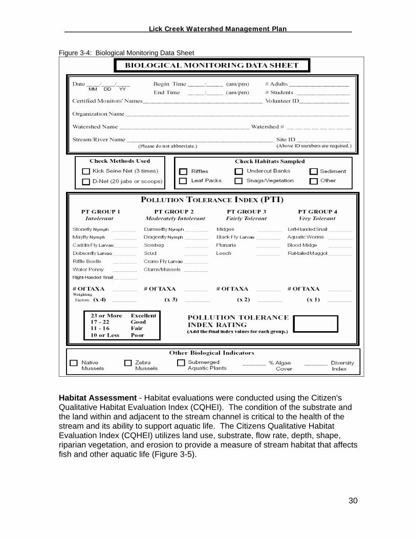
The watershed coordination team would identify a riffle at each site and select a 3’ x 3’ section of the riffle. One member of the team would place the net at the downstream section of the 3’ x 3’ area perpendicular to the flow. The other member of the team would approach from the upstream edge of the sampling area and kick the streambed vigorously for 2-3 minutes until the entire 3’ x 3’ section was disturbed. The “kicker” would then reach into the stream and begin rubbing off particles from cobble stones, rocks, twigs and leaves into the net. Once completed the “netter” would remove the net with a forward upstream scooping motion to maintain the contents of the net. The two together would then go to the shore and begin picking the particles from the net and place them on a sieve. Once the specimens were on the sieve, the watershed coordination team would spray water on all of the particles until the macroinvertebrates were separated from the particles (Figure 3-3). The team would then collect their specimens in jars and conduct this process two additional times for a total of three (3) replicates. The watershed coordination team would then record the presence of each type of organism collected and provide an estimate of the number of each type of organism. This information was then incorporated into the Biological Monitoring Data Sheet, Figure 3-4, to determine the Pollution Tolerance Index Rating (PTIR). Based on the PTIR score, the team was then able to determine whether the water quality conditions were excellent, good, fair, or poor.
29
_________________ Lick Creek Watershed Management Plan_______________
Figure 3-4: Biological Monitoring Data Sheet
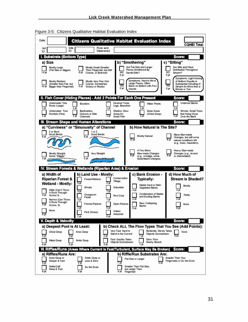
Habitat Assessment - Habitat evaluations were conducted using the Citizen's Qualitative Habitat Evaluation Index (CQHEI). The condition of the substrate and the land within and adjacent to the stream channel is critical to the health of the stream and its ability to support aquatic life. The Citizens Qualitative Habitat Evaluation Index (CQHEI) utilizes land use, substrate, flow rate, depth, shape, riparian vegetation, and erosion to provide a measure of stream habitat that affects fish and other aquatic life (Figure 3-5).
30
_________________ Lick Creek Watershed Management Plan_______________
Figure 3-5: Citizens Qualitative Habitat Evaluation Index
31

_________________ Lick Creek Watershed Management Plan_______________
Evaluating Water Quality Pollutants A number of substances including bacteria, nutrients, oxygen demanding wastes, metals and toxic substances cause water pollution. Pollution refers to the substances that enter surface waters that result in water quality degradation and impairment. Sources of these pollution causing substances are divided into two broad categories: point sources and nonpoint sources (IDEM, 2002). Point and nonpoint sources of pollution are described as follows: Point sources of pollution refer to discharges that enter surface waters through a pipe, ditch or other well defined point of discharge. The term applies to wastewater and storm water discharges from a variety of sources. Wastewater point source discharges include municipal (city, town, and county) and industrial wastewater treatment plants and small domestic wastewater treatment systems that may serve schools, commercial offices, residential subdivisions and individual homes. Storm water point source discharges include storm water discharges associated with industrial activities and storm water discharges from municipal separate storm sewer (MS4s) systems for municipalities that meet the requirements of 327 IAC 15-13. The primary pollutants associated with point source discharges are bacteria, oxygen demanding wastes, nutrients, sediment, color and toxic substances including chlorine, ammonia and metals. Point source dischargers in Indiana must apply for and obtain a National Pollutant Discharge Elimination System (NPDES) permit from the state. Discharge permits are issued under the NPDES program (See Appendix A), which is delegated to Indiana by the US Environmental Protection Agency (EPA). There are no facilities in the watershed which currently hold a NPDES permit Nonpoint sources of pollution refer to discharges of runoff that enter surface waters from storm water runoff, contaminated groundwater, snowmelt or atmospheric deposition. There are many types of land use activities that can serve as sources of nonpoint source pollution including land development, construction, mining operations, crop production, animal feeding lots, timber harvesting, failing septic systems, landfills, roads and paved areas, and wildlife. Sediment and nutrients are major pollution causing substances associated with nonpoint source pollution. Others pollutants can include E. coli bacteria, heavy metals, pesticides, oil and grease, and any other substance that may be washed off the ground or removed from the atmosphere and carried into surface waters. Unlike point source pollution, nonpoint pollution sources are diffuse in nature and occur at random depending on rainfall events. Types of Pollution Causes of pollution refer to the substances that enter surface waters from point and nonpoint sources and result in water quality degradation and impairment. Major causes of water quality impairment include E. coli bacteria, biochemical
32
_________________ Lick Creek Watershed Management Plan_______________
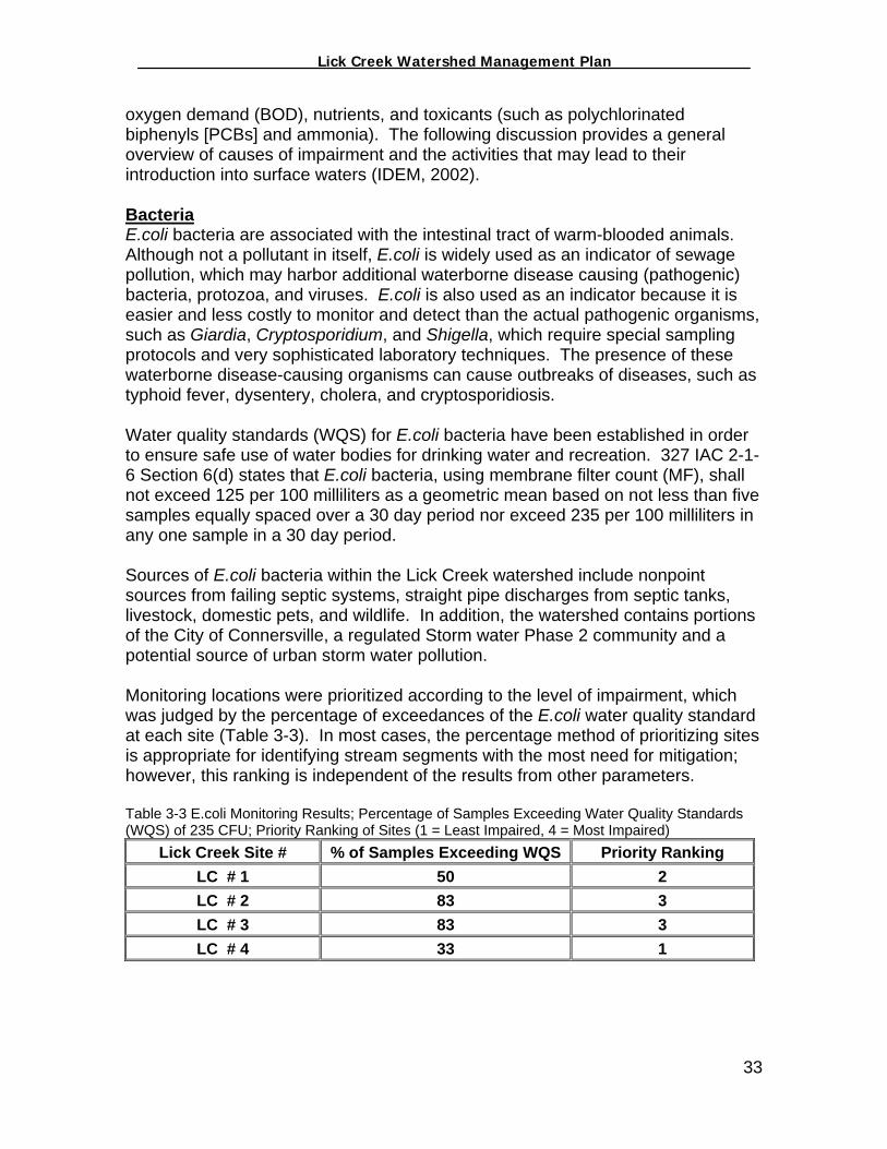
oxygen demand (BOD), nutrients, and toxicants (such as polychlorinated biphenyls [PCBs] and ammonia). The following discussion provides a general overview of causes of impairment and the activities that may lead to their introduction into surface waters (IDEM, 2002). Bacteria E.coli bacteria are associated with the intestinal tract of warm-blooded animals. Although not a pollutant in itself, E.coli is widely used as an indicator of sewage pollution, which may harbor additional waterborne disease causing (pathogenic) bacteria, protozoa, and viruses. E.coli is also used as an indicator because it is easier and less costly to monitor and detect than the actual pathogenic organisms, such as Giardia, Cryptosporidium, and Shigella, which require special sampling protocols and very sophisticated laboratory techniques. The presence of these waterborne disease-causing organisms can cause outbreaks of diseases, such as typhoid fever, dysentery, cholera, and cryptosporidiosis. Water quality standards (WQS) for E.coli bacteria have been established in order to ensure safe use of water bodies for drinking water and recreation. 327 IAC 2-1-6 Section 6(d) states that E.coli bacteria, using membrane filter count (MF), shall not exceed 125 per 100 milliliters as a geometric mean based on not less than five samples equally spaced over a 30 day period nor exceed 235 per 100 milliliters in any one sample in a 30 day period. Sources of E.coli bacteria within the Lick Creek watershed include nonpoint sources from failing septic systems, straight pipe discharges from septic tanks, livestock, domestic pets, and wildlife. In addition, the watershed contains portions of the City of Connersville, a regulated Storm water Phase 2 community and a potential source of urban storm water pollution. Monitoring locations were prioritized according to the level of impairment, which was judged by the percentage of exceedances of the E.coli water quality standard at each site (Table 3-3). In most cases, the percentage method of prioritizing sites is appropriate for identifying stream segments with the most need for mitigation; however, this ranking is independent of the results from other parameters. Table 3-3 E.coli Monitoring Results; Percentage of Samples Exceeding Water Quality Standards (WQS) of 235 CFU; Priority Ranking of Sites (1 = Least Impaired, 4 = Most Impaired)
Lick Creek Site # % of Samples Exceeding WQS Priority Ranking LC # 1 50 2 LC # 2 83 3 LC # 3 83 3 LC # 4 33 1
33
_________________ Lick Creek Watershed Management Plan_______________
Oxygen Consuming Wastes Since maintaining sufficient levels of dissolved oxygen in a waterbody is critical to the survival of most forms of aquatic life, evaluating oxygen-consuming wastes in a river or stream is central to diagnosing the health of a watershed. Pollutants associated with oxygen consuming wastes are typically composed of either decomposing organic matter or chemicals that bind with available instream oxygen to reduce the available concentrations of dissolved oxygen in the water column. Organic causes of oxygen consuming wastes are measured as biochemical oxygen demand (BOD). Although there is not an ambient water quality standard for BOD, the Indiana Department of Natural Resource’s Hoosier Riverwatch Program has published a “rule of thumb” for evaluating BOD concentrations in ambient water quality samples, as follows:
• 1-2 mg/L = Clean water with little organic waste; • 3-5 mg/L = Fairly clean with some organic waste; • 6-9 mg/L = Lots of organic material and bacteria; • 10+ mg/L = Very poor water quality with large amounts of organic material.
Point and nonpoint sources of pollution, such as failing septic systems, straight pipe discharges from septic tanks, livestock, domestic pets, urban and agricultural fertilizers and wildlife can contribute organic wastes to streams. As organic waste decays it binds with available in-stream oxygen, lowering the available oxygen concentrations in a waterbody and stressing resident aquatic life. In addition, organic waste within streams can cause a condition of nutrient enrichment. Monitoring for this project detected the presence of elevated concentrations of nutrients (ammonia) in sufficient quantities to support an overabundance of algae growth within the stream (nutrient enrichment). Although the process of photosynthesis in the algae produces a large volume of oxygen during periods of daylight, respiration by algae during the nighttime hours absorbs more oxygen than the water column can maintain, resulting in times when dissolved oxygen concentrations are significantly reduced or depleted. This situation can be intensified in hot weather and low flow conditions due to the reduced capacity of water to retain dissolved oxygen. Monitoring locations within the Lick Creek watershed were prioritized according to their level of BOD impairment, which was judged by the percentage of exceedances of the five (5) mg/L “rule of thumb” for BOD at each site (Table 3-4).
34

_________________ Lick Creek Watershed Management Plan_______________
Table 3-4 BOD Monitoring Results; Percentage of Samples Exceeding 5 mg/L Rule of Thumb; Priority Ranking of Sites (1 = Least Impaired, 6 = Most Impaired)
Lick Creek Site # % of Samples Exceeding WQS Priority Ranking LC # 1 17 2 LC # 2 0 1 LC # 3 17 2 LC # 4 17 2
Nutrients The term "nutrients" primarily refers to the two major plant macronutrients, phosphorus and nitrogen. These nutrients are common components of fertilizers, animal and human wastes, vegetation, and some industrial processes. Nutrients in surface waters come from both point and nonpoint sources. Nutrients are beneficial to aquatic life in small amounts. However, in over abundance and under certain conditions, they can stimulate the occurrence of algal blooms and excessive plant growth in quiet waters or low flow conditions. Algae blooms and excessive plant growth often reduce the dissolved oxygen content of surface waters through plant respiration and the decomposition of dead algae and other plants (IDEM, 2002). Nitrogen (Ammonia) Within the Lick Creek watershed, nonpoint source discharges of untreated septic effluent, decaying organisms and plant life, and bacterial decomposition of animal waste are the most likely sources of ammonia. Water quality monitoring detected multiple ammonia violations at several locations in the watershed. Water quality standards for ammonia are derived using an equation that considers a sample’s temperature and pH; therefore, there is not a single numerical ammonia standard. As illustrated in Table 3-5, monitoring locations were prioritized according to the level of ammonia impairment, which was judged by the percentage of exceedances of the calculated WQS for each sample. Note: This ranking is independent of the results from other parameters. Table 3-5 Ammonia Monitoring Results; Percentage of Samples exceeding calculated WQS; Priority Ranking of Sites (1 = Least Impaired, 4 = Most Impaired)
Lick Creek Site # % of Samples Exceeding WQS Priority Ranking LC # 1 83 3 LC # 2 17 1 LC # 3 17 1 LC # 4 33 2
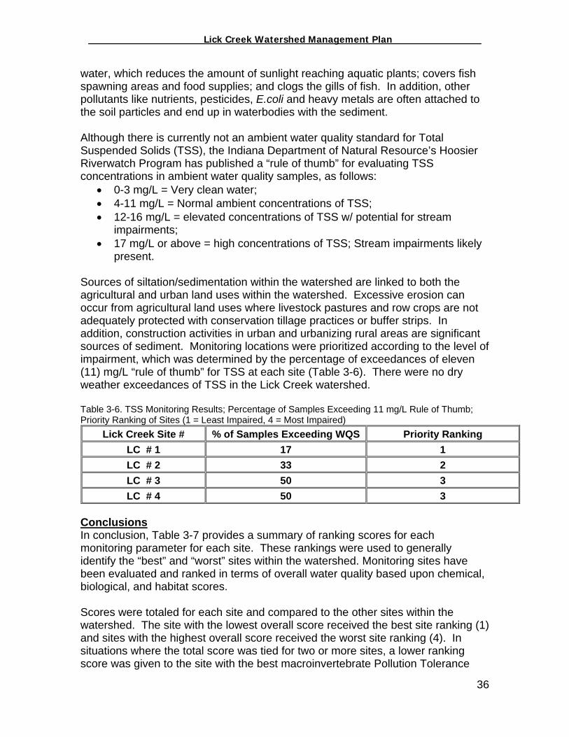
Siltation/Sedimentation Sedimentation occurs when wind or water runoff causes erosion, carries soil particles from an area such as a farm field or stream bank, and transports them to a water body, such as a stream or lake. Excessive sedimentation clouds the
35
_________________ Lick Creek Watershed Management Plan_______________
water, which reduces the amount of sunlight reaching aquatic plants; covers fish spawning areas and food supplies; and clogs the gills of fish. In addition, other pollutants like nutrients, pesticides, E.coli and heavy metals are often attached to the soil particles and end up in waterbodies with the sediment. Although there is currently not an ambient water quality standard for Total Suspended Solids (TSS), the Indiana Department of Natural Resource’s Hoosier Riverwatch Program has published a “rule of thumb” for evaluating TSS concentrations in ambient water quality samples, as follows:
• 0-3 mg/L = Very clean water; • 4-11 mg/L = Normal ambient concentrations of TSS; • 12-16 mg/L = elevated concentrations of TSS w/ potential for stream
impairments; • 17 mg/L or above = high concentrations of TSS; Stream impairments likely
present. Sources of siltation/sedimentation within the watershed are linked to both the agricultural and urban land uses within the watershed. Excessive erosion can occur from agricultural land uses where livestock pastures and row crops are not adequately protected with conservation tillage practices or buffer strips. In addition, construction activities in urban and urbanizing rural areas are significant sources of sediment. Monitoring locations were prioritized according to the level of impairment, which was determined by the percentage of exceedances of eleven (11) mg/L “rule of thumb” for TSS at each site (Table 3-6). There were no dry weather exceedances of TSS in the Lick Creek watershed. Table 3-6. TSS Monitoring Results; Percentage of Samples Exceeding 11 mg/L Rule of Thumb; Priority Ranking of Sites (1 = Least Impaired, 4 = Most Impaired)
Lick Creek Site # % of Samples Exceeding WQS Priority Ranking LC # 1 17 1 LC # 2 33 2 LC # 3 50 3 LC # 4 50 3
Conclusions In conclusion, Table 3-7 provides a summary of ranking scores for each monitoring parameter for each site. These rankings were used to generally identify the “best” and “worst” sites within the watershed. Monitoring sites have been evaluated and ranked in terms of overall water quality based upon chemical, biological, and habitat scores.
Scores were totaled for each site and compared to the other sites within the watershed. The site with the lowest overall score received the best site ranking (1) and sites with the highest overall score received the worst site ranking (4). In situations where the total score was tied for two or more sites, a lower ranking score was given to the site with the best macroinvertebrate Pollution Tolerance
36

_________________ Lick Creek Watershed Management Plan_______________
Index (PTI) score. In addition, all data collected for this project has been summarized and interpreted in Table 3-8. Table 3-7: Summary of Lick Creek Ranking Scores; Priority Ranking of Sites (1 = Least Impaired, 4 = Most Impaired)
Lick Creek Watershed Summary of Sampling Site Rankings
(Refer to Figure 3-1 for a map of Lick Creek monitoring sites) Sample Type LC 1 LC 2 LC 3 LC 4
E.coli 1 1 4 2
BOD 2 1 1 2
Ammonia 2 3 3 4
Sediment 1 1 1 1
Macroinvertebrates 2 1 3 4
Habitat 2 1 3 4
Total 14 9 15 16
Ranking 2 1 3 4
37


_________________ Lick Creek Watershed Management Plan_______________
Table 3-8: Summary of Lick Creek Water Quality Monitoring Data (2002-2003) Lick Creek Watershed
Summary of Chemical Monitoring Results, Pollution Tolerance Index (PTI) Ratings and CQHEI Scores
(Refer to Figure 3-1 for a map of Lick Creek monitoring sites) Sample Type LC 1 LC 2 LC 3 LC 4
Chemical
• 50% of E. coli samples exceed WQS (333-720)
• 2 dry weather E. coli violations
• NH3 elevated during wet weather compared to other sites
• BOD levels consistently higher than other sites (except May 2003)
• Manlove lake appears to be serving as a sediment catch basin, but Site 1 also experiences elevated TSS values during significant rain events (erosion d/s of lake outfall)
• 83% of E. coli samples exceed WQS (267-1147)
• 2 dry weather E. coli violations
• NH3 levels consistent with agricultural practices (average in relation to other sites)
• BOD levels consistently low to average compared to other sites
• TSS levels consistently lower during wet weather events compared to other sites
• 83% of E. coli samples exceed WQS (267-1147)
• 2 dry weather E. coli violations
• Significant NH3 spike on May 21, 2003 (foamy sample)
• BOD spikes occurred in August 2002 and May 2003
• Consistent TSS spikes during wet weather
• 33% of E. coli samples exceed WQS (267-1147)
• 1 dry weather E. coli violation (2220 cfu)
• Significant NH3 spike in June 2002
• Highest BOD in August 2002
• TSS levels consistently higher during wet weather events compared to other sites
Macro* (Two sample average during 2002-2003)
33.5, Excellent 38.5, Excellent 30, Excellent 29, Excellent
Habitat (CQHEI) Scores (two sample average during 2002-2003)
73 74.25 67.5 51
Site Ranking** 2 1 3 4 *100 specimens were not collected as a result of 3 kick samples; Samples were sorted for one hour. ** 1 = Best; 4 = Worst
39
_________________ Lick Creek Watershed Management Plan_______________
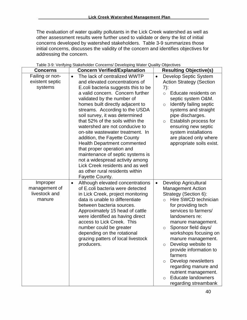
The evaluation of water quality pollutants in the Lick Creek watershed as well as other assessment results were further used to validate or deny the list of initial concerns developed by watershed stakeholders. Table 3-9 summarizes those initial concerns, discusses the validity of the concern and identifies objectives for addressing the concern. Table 3-9: Verifying Stakeholder Concerns/ Developing Water Quality Objectives
Concerns Concern Verified/Explanation Resulting Objective(s) Failing or non-existent septic
systems
• The lack of centralized WWTP and elevated concentrations of E.coli bacteria suggests this to be a valid concern. Concern further validated by the number of homes built directly adjacent to streams. According to the USDA soil survey, it was determined that 52% of the soils within the watershed are not conducive to on-site wastewater treatment. In addition, the Fayette County Health Department commented that proper operation and maintenance of septic systems is not a widespread activity among Lick Creek residents and as well as other rural residents within Fayette County.
• Develop Septic System Action Strategy (Section 7): o Educate residents on
septic system O&M. o Identify failing septic
systems and straight pipe discharges.
o Establish process for ensuring new septic system installations are placed only where appropriate soils exist.
Improper management of
livestock and manure
• Although elevated concentrations of E.coli bacteria were detected in Lick Creek, project monitoring data is unable to differentiate between bacteria sources. Approximately 15 head of cattle were identified as having direct access to Lick Creek. This number could be greater depending on the rotational grazing patters of local livestock producers.
• Develop Agricultural Management Action Strategy (Section 6): o Hire SWCD technician
for providing tech services to farmers/ landowners re: manure management.
o Sponsor field days/ workshops focusing on manure management.
o Develop website to provide information to farmers
o Develop newsletters regarding manure and nutrient management.
o Educate landowners regarding streambank
40

_________________ Lick Creek Watershed Management Plan_______________
41
stabilization methods. Erosion and
sedimentation from agricultural fields, pasture, wood lots and stream banks
• 89% of the Lick Creek watershed is used for agriculture purposes. Although numerous buffers/filters were observed via the windshield survey, elevated concentrations of TSS and nutrients were observed during rain events suggesting a need for complete stream corridor protection via buffers/ filters. Stakeholder concerns were also noted regarding the perceived contributions of fertilizers, herbicides and pesticides associated w/ sediment transport and runoff from agricultural fields. Although no components of this study were appropriate for evaluating validity of this concern, logical conclusions can be drawn regarding the direct connection between applications of agrichemicals and their introduction into the environment.
• Develop Agricultural Management Action Strategy (Section 6): o Establish riparian
buffer/ filter strips. o Increase the utilization
of conservation tillage. o Educate livestock
producers about the water quality impacts of allowing livestock access to creeks and forest lands.
o Educate landowners regarding streambank stabilization methods.
o Educate landowners on the benefits of the WRP and WHIP programs.
o Educate formers on the economic and environmental benefits of pest management.
o Develop “River Friendly Farmer” type Program.
o Collect additional water quality data to determine the magnitude/ mass loadings of pesticides and other agrichemicals in the watershed.
Lack of forestry/ logging best management
practices (BMPs)
• Although elevated concentrations of TSS and Nutrients were observed during rain events, logging was not apparent as a significant land use activity or water quality impact. The IDNR District Forester validated this concern as a common regional problem that needed to be addressed locally.
• Develop Forestry Management Action Strategy (Section 5): o Modify county zoning
regulations to be consistent with natural resource protection strategies and smart growth.
o Educate forest owners
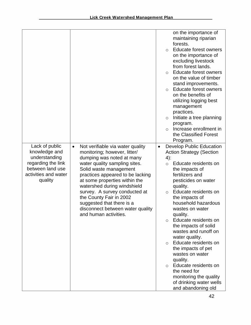
_________________ Lick Creek Watershed Management Plan_______________
on the importance of maintaining riparian forests.
o Educate forest owners on the importance of excluding livestock from forest lands.
o Educate forest owners on the value of timber stand improvements.
o Educate forest owners on the benefits of utilizing logging best management practices.
o Initiate a tree planning program.
o Increase enrollment in the Classified Forest Program.
Lack of public knowledge and understanding
regarding the link between land use
activities and water quality
• Not verifiable via water quality monitoring; however, litter/ dumping was noted at many water quality sampling sites. Solid waste management practices appeared to be lacking at some properties within the watershed during windshield survey. A survey conducted at the County Fair in 2002 suggested that there is a disconnect between water quality and human activities.
• Develop Public Education Action Strategy (Section 4): o Educate residents on
the impacts of fertilizers and pesticides on water quality.
o Educate residents on the impacts of household hazardous wastes on water quality.
o Educate residents on the impacts of solid wastes and runoff on water quality.
o Educate residents on the impacts of pet wastes on water quality.
o Educate residents on the need for monitoring the quality of drinking water wells and abandoning old
42

_________________ Lick Creek Watershed Management Plan_______________
43
wells. o Provide additional
opportunities for community involvement in water quality improvement efforts.
Uncontrolled development in the
watershed
• According to the Area Plan Commission (APC) and other members of the FCWI, zoning ordinances in Connersville/ Fayette County are not protective of water resources. Other portions of the county are developing at a more rapid rate than the Lick Creek watershed, but as a proactive measure, the FCWI feels that local zoning ordinances should be modified in an effort to protect Lick Creek and other streams within Fayette County.
• Develop Local Government Action Strategy (Section 8): o Hire an erosion and
sediment control specialist to better control the impacts of construction/development projects.
o Provide training to local developers regarding the use of ESC best management practices.
o Educate political leaders, developers and landowners about the impacts of unchecked development.
Nutrient and fertilizer runoff and
infiltration
• 89% of the watershed is in agricultural land uses. The windshield survey noted the presence of some stream/ditch buffers throughout the watershed, but the survey did not adequately identify buffers from all stream segments. Aerial photography was used to identify potential areas in need of buffer or filter strips within the watershed. Approximately 23,586 linear feet were identified as potential buffer projects.
• Develop Agricultural Management Action Strategy (Section 6): o Hire SWCD technician
for providing tech services to farmers/ landowners re: manure management.
o Sponsor field days/ workshops focusing on manure management.
o Develop website to provide information to farmers. Develop newsletters regarding manure and nutrient management.
o Establish riparian
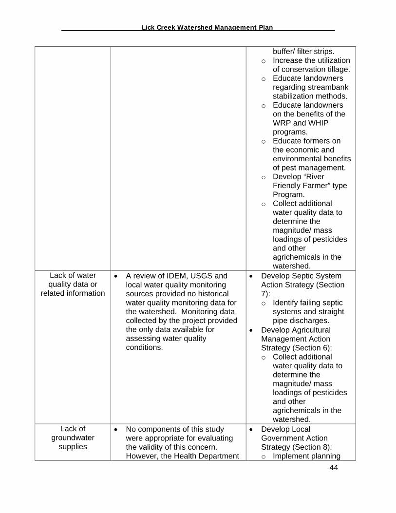
_________________ Lick Creek Watershed Management Plan_______________
44
buffer/ filter strips. o Increase the utilization
of conservation tillage. o Educate landowners
regarding streambank stabilization methods.
o Educate landowners on the benefits of the WRP and WHIP programs.
o Educate formers on the economic and environmental benefits of pest management.
o Develop “River Friendly Farmer” type Program.
o Collect additional water quality data to determine the magnitude/ mass loadings of pesticides and other agrichemicals in the watershed.
Lack of water quality data or
related information
• A review of IDEM, USGS and local water quality monitoring sources provided no historical water quality monitoring data for the watershed. Monitoring data collected by the project provided the only data available for assessing water quality conditions.
• Develop Septic System Action Strategy (Section 7): o Identify failing septic
systems and straight pipe discharges.
• Develop Agricultural Management Action Strategy (Section 6): o Collect additional
water quality data to determine the magnitude/ mass loadings of pesticides and other agrichemicals in the watershed.
Lack of groundwater
supplies
• No components of this study were appropriate for evaluating the validity of this concern. However, the Health Department
• Develop Local Government Action Strategy (Section 8): o Implement planning

_________________ Lick Creek Watershed Management Plan_______________
noted that residents in particular areas of Fayette County must bring in outside water supplies during portions of the year due to dry wells.
tools to ensure protection of natural resources via septic system density requirements and water supply availability ordinance.
Flooding • Stakeholder concerns regarding unchecked development could be generating more impervious surfaces/ stormwater runoff. Stakeholder comments suggested that logging may be contributing to increased flooding and erosion. Fayette County Emergency Management did comment that flooding is potentially a major issue throughout Fayette County and should be considered as a threat to water quality.
• Develop Local Government Action Strategy (Section 8): o Implement planning
tools to ensure protection of natural resources via floodplain protection/ management ordinance.
• Develop Agricultural Management Action Strategy (Section 6): o Establish riparian
buffer/ filter strips. o Educate landowners
regarding streambank stabilization methods.
• Develop Forestry Management Action Strategy (Section 5): o Educate forest owners
on the importance of maintaining riparian forests.
o Initiate a tree planning program.
• Develop Public Education Action Strategy (Section 4): o Hire an erosion and
sediment control specialist to better control the impacts of construction/development projects.
o Educate political leaders, developers and landowners about
45
_________________ Lick Creek Watershed Management Plan_______________
the impacts of unchecked development (impervious surfaces).
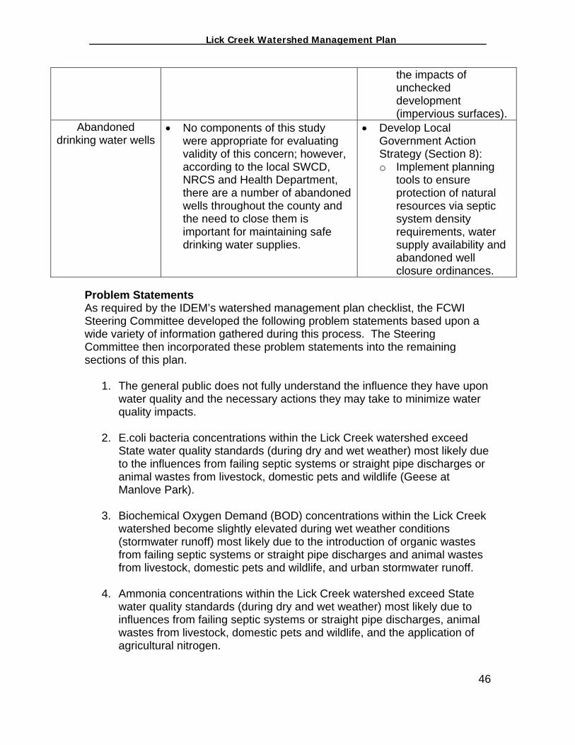
Abandoned drinking water wells
• No components of this study were appropriate for evaluating validity of this concern; however, according to the local SWCD, NRCS and Health Department, there are a number of abandoned wells throughout the county and the need to close them is important for maintaining safe drinking water supplies.
• Develop Local Government Action Strategy (Section 8): o Implement planning
tools to ensure protection of natural resources via septic system density requirements, water supply availability and abandoned well closure ordinances.
Problem Statements As required by the IDEM’s watershed management plan checklist, the FCWI Steering Committee developed the following problem statements based upon a wide variety of information gathered during this process. The Steering Committee then incorporated these problem statements into the remaining sections of this plan.
1. The general public does not fully understand the influence they have upon water quality and the necessary actions they may take to minimize water quality impacts.
2. E.coli bacteria concentrations within the Lick Creek watershed exceed
State water quality standards (during dry and wet weather) most likely due to the influences from failing septic systems or straight pipe discharges or animal wastes from livestock, domestic pets and wildlife (Geese at Manlove Park).
3. Biochemical Oxygen Demand (BOD) concentrations within the Lick Creek
watershed become slightly elevated during wet weather conditions (stormwater runoff) most likely due to the introduction of organic wastes from failing septic systems or straight pipe discharges and animal wastes from livestock, domestic pets and wildlife, and urban stormwater runoff.
4. Ammonia concentrations within the Lick Creek watershed exceed State
water quality standards (during dry and wet weather) most likely due to influences from failing septic systems or straight pipe discharges, animal wastes from livestock, domestic pets and wildlife, and the application of agricultural nitrogen.
46
_________________ Lick Creek Watershed Management Plan_______________
5. Total Suspended Solids (TSS) concentrations within the Lick Creek watershed become elevated during wet weather conditions (stormwater runoff) most likely due to the lack of conservation tillage practices and resulting erosion on agricultural land uses and from naturally occurring erosion from Highly Erodible Soils (HEL) within the watershed.
6. Habitat conditions at Site 4 in the Lick Creek watershed are somewhat
degraded due to significant erosion upstream of this site most likely due to increasing stream velocities from urbanization and the presences of Highly Erodible Soils (HEL).
Sections 4 through 8 contain objectives to address the different problem statements listed above. Given the need for water quality education and the ability of the FCWI, education was deemed the overall priority and the necessary first step in improving water quality conservation practices within the Lick Creek watershed. While the sections themselves are not in order of priority, the different objectives within each of these sections are listed in order of priority as determined by the FCWI Steering Committee.
47

_________________ Lick Creek Watershed Management Plan_______________
This page intentionally left blank
48

_________________ Lick Creek Watershed Management Plan_______________
IV. Public Education and Involvement Managing pollution is often considered the job of local, state and federal government. Certainly, good planning and implementation by all of these entities is important to a successful water quality protection program, however, it is also important that individual homeowners understand their role in water quality protection and their impact on the larger community. The FCWI Steering Committee felt that in order for conservation efforts to occur as a result of this plan, all members of the community need to fully understand water quality, how their day to day activities impact water quality and what measures are necessary to improve and protect water quality within the Lick Creek watershed. The FCWI Steering Committee acknowledges the different agencies and organizations within Fayette County committed to environmental education but realized that an education program specific to the Lick Creek watershed did not exist. In an attempt to fill this gap, the Community Education Coalition (CEC) applied for a Section 319 Grant to obtain the necessary funding to implement the education components outlined in this watershed plan. The CEC’s grant application for $106,000 was approved and education activities are scheduled to begin in January of 2004. The CEC will hire or contract with an individual for a two-year position. The Environmental Educator shall be responsible for working with a variety of organizations within Fayette County including: the FCSWCD Educator, the Three Rivers Solid Waste Management District, science teachers with the Connersville Public School System, 4-H Leaders, and Purdue Extension. There are numerous potential pollution sources in and around every home within the Lick Creek watershed that can affect the health of the household, the community, and the environment. Such sources include: 1. Fertilizers and Pesticides
If not applied or managed properly, fertilizers and pesticides can migrate into surface water and groundwater supplies. Via runoff and infiltration, these materials have the potential to cause algae blooms, fish kills, and human illnesses. To limit the impacts fertilizers and pesticides have on water quality, residents should:
Carefully follow product’s application instructions and warnings. Apply fertilizer and pesticides only to target areas. Follow recommended watering practices and avoid excess watering after
application Do not sprinkle product onto paved or other areas that drain into the
stream or ditch. 49
_________________ Lick Creek Watershed Management Plan_______________
Avoid unnecessary pesticide, fertilizer, or water use by planting native vegetation that has adapted to the local area.
Store fertilizers and pesticides in an area that minimizes the risk associated with an accidental spill.
In the event of a fertilizer or pesticide spill, clean up immediately and do not dispose of the waste by dumping over the fencerow or by dumping the materials down the sink or toilet.
Dispose of unused fertilizers and pesticides at the Three Rivers Solid Waste Management District’s Tox-A-Way Day.
Do not dispose of chemicals in sinks, toilets, storm drains, drainage ditches or anywhere else besides a licensed facility.
The monitoring and assessment activities conducted during this project could not confirm or deny that fertilizers and pesticides are a direct threat to the water quality of Lick Creek. Steering Committee members, however, felt that promoting proper fertilizer and pesticide management should be a focus of the FCWI based on their overarching goal of protecting water quality within the Lick Creek watershed. 2. Household Hazardous Wastes (HHW)
Many household products such as gasoline, motor oil, antifreeze, paints, preservatives, brush cleaners, and solvents can negatively impact surface and groundwater supplies if not utilized, stored, and disposed of properly. Via runoff and infiltration, these materials have the potential to cause fish kills and human illnesses. To minimize the impacts associated with these common household chemicals, homeowners should:
Never pour chemicals down the drain since septic tanks do not treat these materials and these chemicals could lead to septic system failure.
Buy products with the least amount of toxic material. Store materials in a fashion that allows for the containment of the material
in the event there is an accidental spill. Clean up material spills immediately and properly. Dispose of unnecessary chemicals annually through the Three Rivers
Solid Waste Management District’s Tox-A-Way Day. The monitoring and assessment activities conducted during this project could not confirm or deny that household hazardous wastes are a direct threat to Lick Creek, however, Steering Committee members felt that HHW should be a focus of the FCWI based on their overarching goal of protecting water quality within the Lick Creek watershed. 3. Solid Wastes
Some residents often accrue a wide variety of solid waste materials on their property. Disposal of solid waste in ravines and streams is not uncommon. Such items as tires, appliances, old vehicles and other
50

_________________ Lick Creek Watershed Management Plan_______________
items have the ability to contaminate surface and ground water supplies. Also, the accumulation of such materials is not aesthetically appealing and can pose other health risks. Tires, buckets, and old drums, for instance, tend to accumulate water, which in turn provides prime habitat for mosquito reproduction. With the ever-increasing threat of diseases such as the West Nile Virus, homeowners should minimize the accumulation of these materials. To minimize the water quality and health impacts associated with solid waste, homeowners should:
Dispose annually of appliances and tires through the Three Rivers Solid Waste Management Districts Tox-A-Way day.
If solid waste is stored, make sure there are no chemicals inside the items that could potentially leak from containers and drain to nearby streams or infiltrate to groundwater supplies.
Store tires inside or cover them until they can be disposed of properly.
Do not dispose of solid waste anywhere other than a sanitary landfill or a recycling facility.
Solid waste accumulation was identified at various residents throughout the watershed during the “windshield” assessment conducted by the watershed coordinator and is discussed in the Problem Statement of Section 3. Realizing the potential for water quality and health problems associated with such activities, the Steering Committee felt that education oriented towards the proper disposal of solid waste should be part of their efforts.
51
4. Pet Wastes When people consider the impacts animals have on water quality, many do not think of pets. However, if pet wastes are disposed of incorrectly, they can cause water pollution. More than half of all U.S. households own a dog, cat, or other pet. Although each household only generates a small amount of pet waste, these small amounts can add up to a water quality problem (North Carolina State University, 2003).
Droppings from dogs and cats and other domesticated pets can cause two kinds of problems. First, pet wastes contain nutrients and bacteria that can promote the growth of algae and other waterborne diseases. Second, animal droppings are a source of pests and disease. Pets, children playing outside, and adults gardening are most at risk of contracting illnesses from some of the bacteria and parasites found in pet waste. Flies may also spread diseases from animal waste. Diseases that can be transmitted from pet waste to humans include leptospirosis, campylobacteriosis, salmonellocis, and toxoplasmosis (North Carolina State University, 2003).
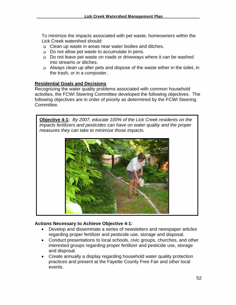
_________________ Lick Creek Watershed Management Plan_______________
To minimize the impacts associated with pet waste, homeowners within the Lick Creek watershed should:
Clean up waste in areas near water bodies and ditches. Do not allow pet waste to accumulate in pens. Do not leave pet waste on roads or driveways where it can be washed
into streams or ditches. Always clean up after pets and dispose of the waste either in the toilet, in
the trash, or in a composter. Residential Goals and Decisions Recognizing the water quality problems associated with common household activities, the FCWI Steering Committee developed the following objectives. The following objectives are in order of priority as determined by the FCWI Steering Committee.
A
Objective 4-1: By 2007, educate 100% of the Lick Creek residents on the impacts fertilizers and pesticides can have on water quality and the proper measures they can take to minimize those impacts.
ctions Necessary to Achieve Objective 4-1: • Develop and disseminate a series of newsletters and newspaper articles
regarding proper fertilizer and pesticide use, storage and disposal. • Conduct presentations to local schools, civic groups, churches, and other
interested groups regarding proper fertilizer and pesticide use, storage and disposal.
• Create annually a display regarding household water quality protection practices and present at the Fayette County Free Fair and other local events.
52
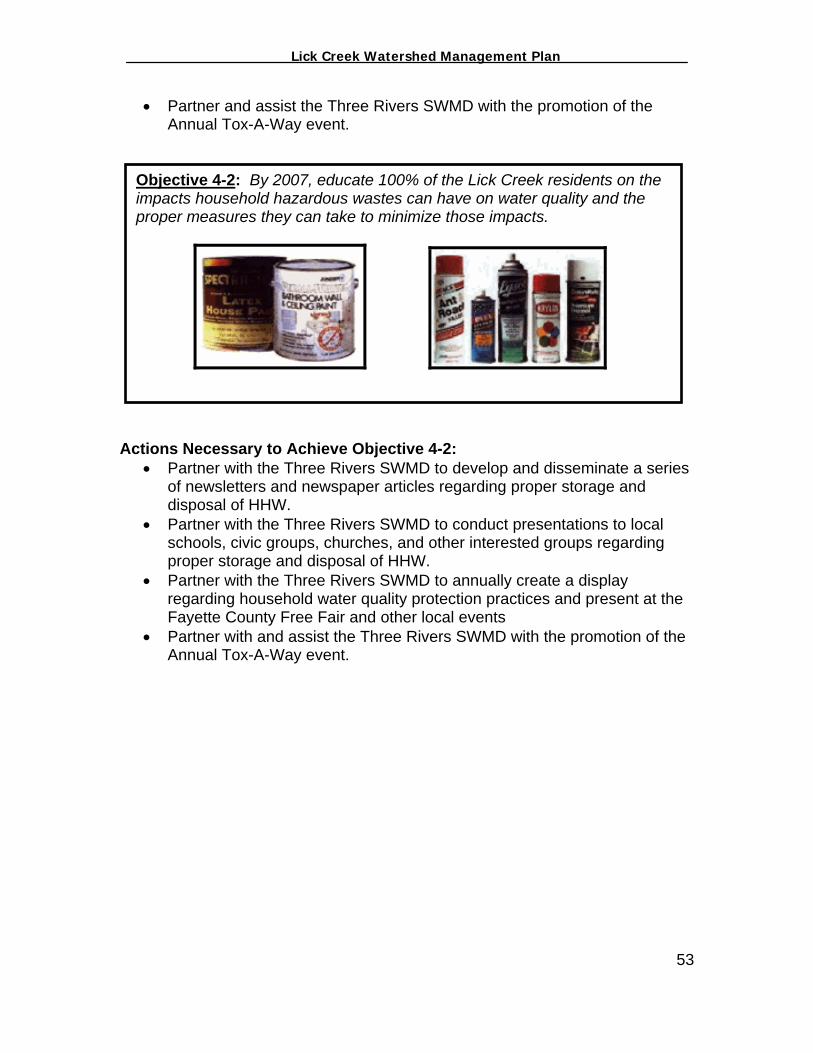
_________________ Lick Creek Watershed Management Plan_______________
• Partner and assist the Three Rivers SWMD with the promotion of the Annual Tox-A-Way event.
Objective 4-2: By 2007, educate 100% of the Lick Creek residents on the impacts household hazardous wastes can have on water quality and the proper measures they can take to minimize those impacts.
Actions Necessary to Achieve Objective 4-2: • Partner with the Three Rivers SWMD to develop and disseminate a series
of newsletters and newspaper articles regarding proper storage and disposal of HHW.
• Partner with the Three Rivers SWMD to conduct presentations to local schools, civic groups, churches, and other interested groups regarding proper storage and disposal of HHW.
• Partner with the Three Rivers SWMD to annually create a display regarding household water quality protection practices and present at the Fayette County Free Fair and other local events
• Partner with and assist the Three Rivers SWMD with the promotion of the Annual Tox-A-Way event.
53

_________________ Lick Creek Watershed Management Plan_______________
Objective 4-3: By 2007, educate 100% of the Lick Creek residents on the impacts the accumulation of solid wastes can have on water quality and the proper measures they can take to minimize those impacts.
Actions Necessary to Achieve Objective 4-3: • Partner with the Three Rivers SWMD to develop and disseminate a series
of newsletters and newspaper articles regarding the importance of proper solid waste disposal and recycling opportunities within Fayette County.
• Partner with the Three Rivers SWMD to conduct presentations to local schools, civic groups, churches, and other interested groups regarding the proper disposal of solid waste and the local laws that prohibit such activities.
• Partner with the Three Rivers SWMD to create a display regarding proper solid waste disposal and recycling opportunities within Fayette County practices and present each year at the Fayette County Free Fair and other local events
• Partner and assist the Three Rivers SWMD with the promotion of the Annual Tox-A-Way event.
54

_________________ Lick Creek Watershed Management Plan_______________
Objective 4-4: By 2007, educate 100% of the Lick Creek residents on the importance of annually monitoring the water quality of functioning drinking water wells and properly closing abandoned wells.
Actions Necessary to Achieve Objective 4-4: • Develop and disseminate a series of newsletters and newspaper articles
regarding how to monitor and the importance of monitoring well water quality.
• Develop and disseminate a series of newsletters and newspaper articles regarding the importance of plugging abandoned wells.
• Conduct presentations to local schools, civic groups, churches, and other interested groups highlighting how to and the importance of monitoring well water quality and plugging abandoned wells.
• Create annually a display regarding how to and the importance of monitoring well water quality and plugging abandoned wells.
• Continue the Fayette County SWCD cost-share program for plugging abandoned wells.
55
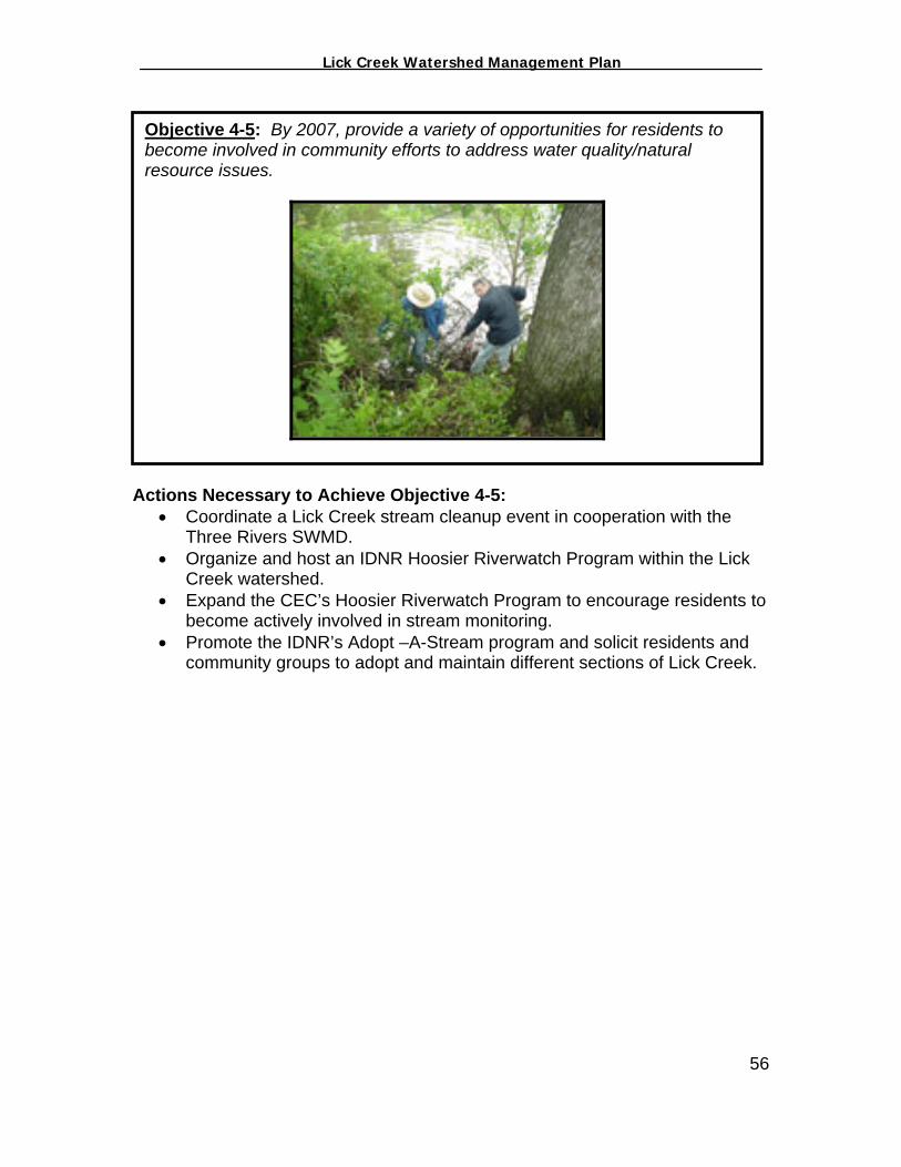
_________________ Lick Creek Watershed Management Plan_______________
Objective 4-5: By 2007, provide a variety of opportunities for residents to become involved in community efforts to address water quality/natural resource issues.
Actions Necessary to Achieve Objective 4-5: • Coordinate a Lick Creek stream cleanup event in cooperation with the
Three Rivers SWMD. • Organize and host an IDNR Hoosier Riverwatch Program within the Lick
Creek watershed. • Expand the CEC’s Hoosier Riverwatch Program to encourage residents to
become actively involved in stream monitoring. • Promote the IDNR’s Adopt –A-Stream program and solicit residents and
community groups to adopt and maintain different sections of Lick Creek.
56
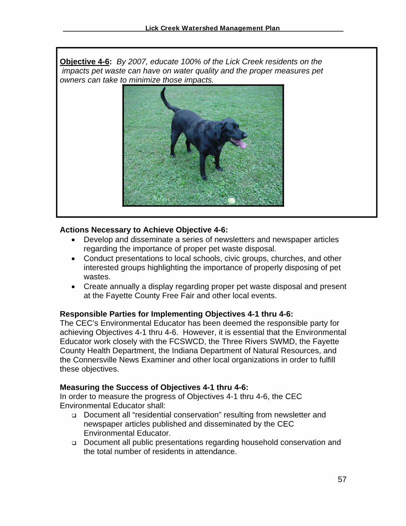
_________________ Lick Creek Watershed Management Plan_______________
Objective 4-6: By 2007, educate 100% of the Lick Creek residents on the impacts pet waste can have on water quality and the proper measures pet owners can take to minimize those impacts.
Actions Necessary to Achieve Objective 4-6: • Develop and disseminate a series of newsletters and newspaper articles
regarding the importance of proper pet waste disposal. • Conduct presentations to local schools, civic groups, churches, and other
interested groups highlighting the importance of properly disposing of pet wastes.
• Create annually a display regarding proper pet waste disposal and present at the Fayette County Free Fair and other local events.
Responsible Parties for Implementing Objectives 4-1 thru 4-6: The CEC’s Environmental Educator has been deemed the responsible party for achieving Objectives 4-1 thru 4-6. However, it is essential that the Environmental Educator work closely with the FCSWCD, the Three Rivers SWMD, the Fayette County Health Department, the Indiana Department of Natural Resources, and the Connersville News Examiner and other local organizations in order to fulfill these objectives. Measuring the Success of Objectives 4-1 thru 4-6: In order to measure the progress of Objectives 4-1 thru 4-6, the CEC Environmental Educator shall:
Document all “residential conservation” resulting from newsletter and newspaper articles published and disseminated by the CEC Environmental Educator.
Document all public presentations regarding household conservation and the total number of residents in attendance.
57
_________________ Lick Creek Watershed Management Plan_______________
Document attendance at stream clean-up events, water quality monitoring events, and make record of those individuals and organizations that agree to participate in IDNR’s Adopt-A-Stream program.
Document and track, when possible, the number of active wells monitored and the total abandoned wells plugged on a quarterly basis.
Document the total tonnage of waste generated through the Lick Creek Clean-Up and the total number of participants involved.
Begin tracking, by watershed, the total number of participants who participate in the annual Three Rivers SWMD Tox-A-Way event.
Critical Residential Areas Educating all residents within the Lick Creek watershed is a priority of FCWI Steering Committee. The Steering Committee realizes that in order for conservation to occur as a result of this plan, all residents need to better understand water quality and how their daily activities impact water quality. Also, all residents shall have the opportunity to get involved in community activities to improve and protect water quality. All residents shall have access to all educational literature developed by the CEC’s Environmental Educator and be made aware of events such as the “stream clean-up” and stream monitoring. The segment of stream in which the clean-up will take place has yet to be determined and will be decided upon through outreach efforts to local residents. Funding Necessary to Implement Objectives 4-1 thru 4-6: The Section 319 Grant acquired by the CEC to fund the Environmental Education Coordinator should provide the necessary funds to implement the majority of the actions listed above. The Three Rivers SWMD has agreed to provide the necessary funds from their operating budget to assist the FCWI in the Lick Creek Stream Clean-Up. At the time this watershed plan was being developed, the Fayette County SWCD was providing cost-share funds to residents and landowners to plug abandoned wells. The FCSWCD had acquired those funds from the Indiana Association of Soil and Water Conservation District’s Clean Water Indiana program. It is a possibility that the FCSWCD could obtain additional funds from that organization or other similar entities. Additional funding needs will be assessed as implementation occurs.
58
_________________ Lick Creek Watershed Management Plan_______________
V. Forested Land in the Lick Creek Watershed According to the U.S. Forest Service inventory data, Fayette County is approximately 20% to 25% forested with virtually all of that acreage being owned by private landowners. However, the Lick Creek watershed, located in Posey and Harrison Townships, possesses only 755 acres of deciduous forest and 2 acres of coniferous forest according to GAP Land Use Data (Figure 5-1). Combined, forestland exists only within 8% of the watershed. Benefits of Forested Land Forests provide a wide variety of benefits to the Lick Creek community:
Timber Production – Properly managed forests can provide significant financial returns.
Wildlife – Properly managed forests provide the necessary habitat for the
many plants and animals of the watershed helping maintain biodiversity and healthy biological communities.
Watershed Protection - Forested land does a better job of protecting
surface water quality than do most other land conditions and uses. The leaf canopy in forests help absorb the energy of heavy rain, slowing the erosive effects of direct rain on bare soil. Root structures in the soil also help control erosion from the forest. Leaf litter and decaying wood help build a healthy soil where erosion-controlling plant life and well-balanced nutrients can better serve a healthy ecosystem and shade provided by trees helps maintain water temperatures necessary for aquatic life.
Flood Control – Forests have a tremendous value as a regulator of water
flow by increasing the time rainwater takes to move through a drainage system minimizing runoff and consequential erosion. By minimizing erosion, forests inhibit sedimentation, which can otherwise reduce the storage capacity of a stream. Streams that have succumbed to extensive sedimentation can often flood after significant rain events.
Recreation and Aesthetics - Hunting, camping, bird watching, and hiking
are just a few of the almost limitless recreational activities forests provide.
Social Values – Undoubtedly, human lives are enhanced by the solitude and beauty the woods provide. Being renewable, the use of wood products in our daily lives will lessen our use of nonrenewable resources - an ecologically desirable consequence.
59
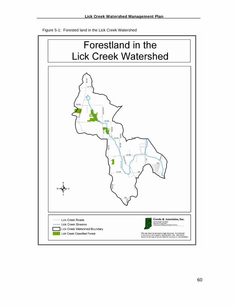
_________________ Lick Creek Watershed Management Plan_______________
Figure 5-1: Forested land in the Lick Creek Watershed
60

_________________ Lick Creek Watershed Management Plan_______________
Forestry Issues in the Lick Creek Watershed per IDNR District Forester Jayson Waterman, District Forester with the Indiana Department of Natural Resources, presented a document to the FCWI Steering Committee highlighting Fayette County’s forestry issues. Those issues include:
Lack of Forest Knowledge The Lick Creek watershed is similar to the rest of the state in terms of forest management. Many landowners make forest management decisions with little or no knowledge of the resource they own. Consequently, bad decisions are made, and it can take the forest decades to recover. Even when drastic mistakes are avoided, most forests are still not managed such that they can reach their potential. Hence, one of the major problems is the lack of landowners’ general forestry knowledge.
Suboptimal Species Composition As a consequence of that lack of knowledge and past use, much of the watershed’s forests are choked with vines, and have suboptimal species composition. These factors contribute to many forests’ poor health. Utilizing the services of a professional forester can remedy many of these problems through selective, improvement timber harvests and timber stand improvements (TSI).
Grazing Factors Many forests in the county, including many acres in the Lick Creek watershed, are subject to grazing by livestock herds, primarily cattle. Cattle hooves crush, chop and destroy the duff layer and leaf litter on the forest floor, increasing the likelihood of it washing away in heavy rain. Without these layers of organic matter, soils are highly vulnerable to erosion. The reduction of soil exposes tree roots, allowing hooves to damage root surfaces. These "open wounds" invite invasions of fungi, insects and bacteria that can damage tree health and greatly reduce the market value of the timber (Missouri Conservationist, 2003).
Highly Erodible Lands Many highly erodible sites within the Lick Creek watershed are in row crop production. These areas, however, are best suited for growing trees, which could reduce soil erosion and sedimentation and improve wildlife habitat. Such sites could be planted to trees for long-term protection of these sensitive areas. Forestry Goals and Decisions The forestry goals of the FCWI are to improve upon the issues identified by the IDNR District Forester. In addition, the FCWI Steering Committee hopes to encourage the modification of zoning regulations within Fayette County to better manage growth in rural areas such as the Lick Creek watershed and, in turn, maintain the limited acres of highly productive forestlands within the watershed. Overall, the FCWI hopes to boost the community’s knowledge and understanding of the economic and environmental benefits forested lands provide which will in turn provide benefit to the water quality conditions of Lick Creek. To achieve this,
61
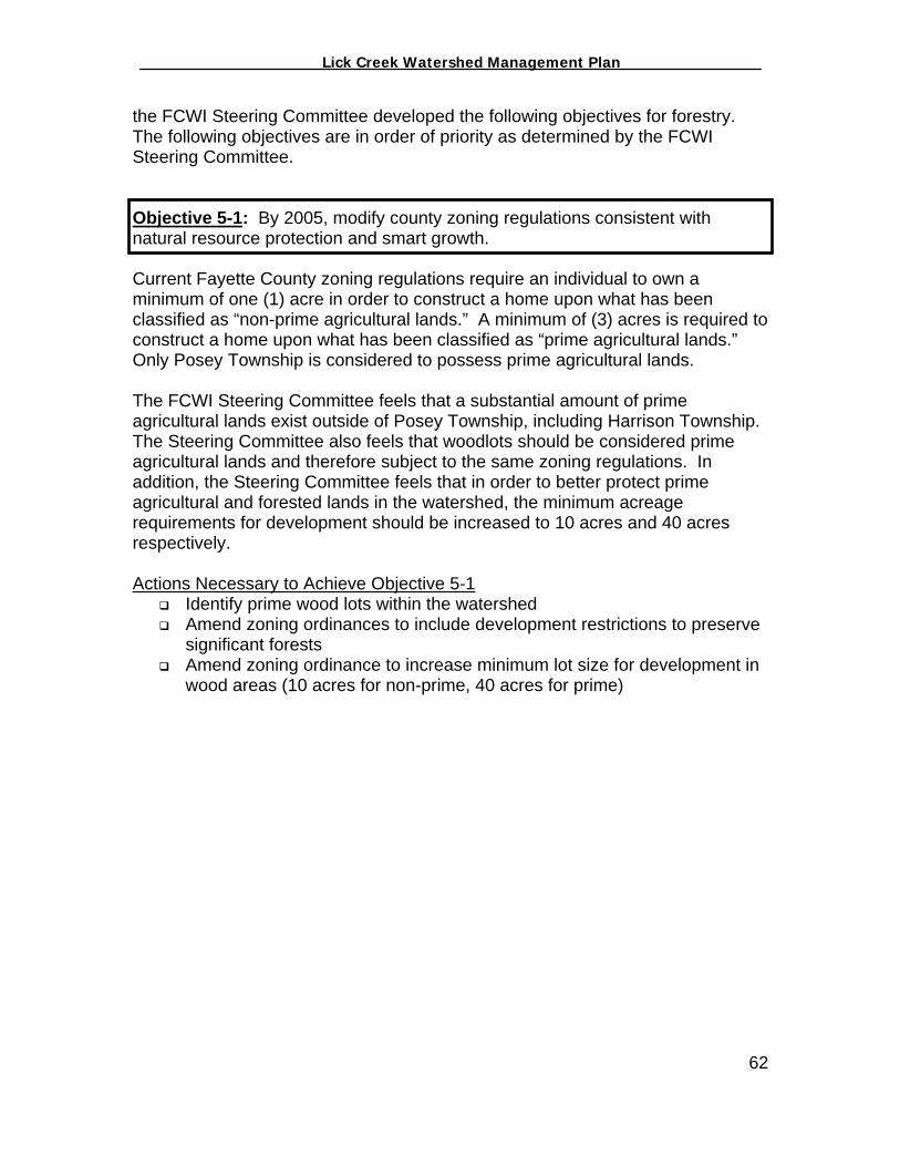
_________________ Lick Creek Watershed Management Plan_______________
the FCWI Steering Committee developed the following objectives for forestry. The following objectives are in order of priority as determined by the FCWI Steering Committee. Objective 5-1: By 2005, modify county zoning regulations consistent with natural resource protection and smart growth.
Current Fayette County zoning regulations require an individual to own a minimum of one (1) acre in order to construct a home upon what has been classified as “non-prime agricultural lands.” A minimum of (3) acres is required to construct a home upon what has been classified as “prime agricultural lands.” Only Posey Township is considered to possess prime agricultural lands. The FCWI Steering Committee feels that a substantial amount of prime agricultural lands exist outside of Posey Township, including Harrison Township. The Steering Committee also feels that woodlots should be considered prime agricultural lands and therefore subject to the same zoning regulations. In addition, the Steering Committee feels that in order to better protect prime agricultural and forested lands in the watershed, the minimum acreage requirements for development should be increased to 10 acres and 40 acres respectively. Actions Necessary to Achieve Objective 5-1
Identify prime wood lots within the watershed Amend zoning ordinances to include development restrictions to preserve
significant forests Amend zoning ordinance to increase minimum lot size for development in
wood areas (10 acres for non-prime, 40 acres for prime)
62
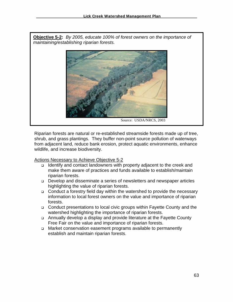
_________________ Lick Creek Watershed Management Plan_______________
Objective 5-2: By 2005, educate 100% of forest owners on the importance of maintaining/establishing riparian forests.Source: USDA/NRCS, 2003
Riparian forests are natural or re-established streamside forests made up of tree, shrub, and grass plantings. They buffer non-point source pollution of waterways from adjacent land, reduce bank erosion, protect aquatic environments, enhance wildlife, and increase biodiversity. Actions Necessary to Achieve Objective 5-2
Identify and contact landowners with property adjacent to the creek and make them aware of practices and funds available to establish/maintain riparian forests.
Develop and disseminate a series of newsletters and newspaper articles highlighting the value of riparian forests.
Conduct a forestry field day within the watershed to provide the necessary information to local forest owners on the value and importance of riparian forests.
Conduct presentations to local civic groups within Fayette County and the watershed highlighting the importance of riparian forests.
Annually develop a display and provide literature at the Fayette County Free Fair on the value and importance of riparian forests.
Market conservation easement programs available to permanently establish and maintain riparian forests.
63

_________________ Lick Creek Watershed Management Plan_______________
Objective 5-3: By 2005, educate 100% of forest owners on the importance of excluding livestock from woodlands.
Source: USDA/NRCS, 2003
Excluding livestock from forestland helps preserve the integrity of the land. Cattle hooves crush, chop and destroy the duff layer and leaf litter on the forest floor, increasing the likelihood of it washing away in heavy rain. Without these layers of organic matter, soils are highly vulnerable to erosion. The reduction of soil exposes tree roots, allowing hooves to damage root surfaces. These "open wounds" invite invasions of fungi, insects and bacteria that can damage tree health and greatly reduce the market value of the timber (Missouri Conservationist, 2003). Actions Necessary to Achieve Objective 5-3
Conduct a forestry field day within the watershed to provide the necessary information to local forest owners on the value and importance of excluding livestock from forested lands.
Develop and disseminate a series of newsletters and newspaper articles highlighting the importance excluding livestock from forested lands.
Conduct presentations to local civic groups within Fayette County and the watershed highlighting the importance of excluding livestock from forested lands.
Develop annually a display and provide literature at the Fayette County Free Fair on the value and importance of excluding livestock from forested lands.
Promote available funding programs to exclude cattle from woodlands.
64

_________________ Lick Creek Watershed Management Plan_______________
Objective 5-4: By 2005, educate 100% of forest owners on the value of timber stand improvements (TSI)
Source: Pike Lumber Co., 2002
What is TSI? There are circumstances when a forested area can be improved upon by doing more than just allowing the trees to grow. One such circumstance would be if an area had a timber harvest in which only the most desirable mature trees were taken out and mostly inferior trees—lower value species, or damaged or diseased trees—were left to occupy the forest canopy (a practice called "high grading"). Another case would be where a very dense stand of young trees needed to be thinned in order to optimize tree health and production of fruits and timber. In situations like these, timber stand improvement (TSI) can be applied to make the most of the species and number of trees present for wildlife and timber production. TSI involves actively managing a stand of trees to improve its species composition, structure, health, and growth (Kentucky Department of Fish and Wildlife, 2003). In many cases TSI involves cutting down or deadening trees that are considered to be of poorer species or quality to improve the growing conditions for the remaining trees. Thus the term TSI is applied to "crop tree release" or "thinning" operations, because some trees in an existing stand are removed or thinned out to favor selected trees ("crop trees") that should yield increased fruit or timber as a result of the improvement work.
65

_________________ Lick Creek Watershed Management Plan_______________
Benefits of TSI Whereas trees in a dense stand tend to put most of their energy into vertical growth to obtain sunlight, trees that have been released from intense competition through TSI put more of their energy into crown and basal growth. Increased crown growth in turn yields increased fruit production while increased trunk growth yields more timber. TSI can also reduce the time needed for crop trees to reach maturity and optimal fruit production; sapling and pole-sized trees that have more freedom to grow produce much sooner than crowded trees (Kentucky Department of Fish and Wildlife, 2003). Another benefit of TSI is increased timber production. With more sunlight, nutrients, and moisture going to fewer trees after TSI, released trees can put on more diameter—meaning increased timber volume, quality, and potential revenue for the landowner. Other benefits of TSI include the option of using culled trees for firewood, using the culled trees to create snags or brush piles for wildlife cover, and putting woody material on the forest floor. The latter benefits a number of wildlife species, such as ruffed grouse (that use downed logs from which to attract mates), white-footed mice and eastern cottontails (that may hide under logs or treetops), and pileated woodpeckers (that feed on termites and grubs in decaying logs). This also creates more open canopies, which allow more light to penetrate the ground. This improves habitat for some wildlife species (Kentucky Department of Fish and Wildlife, 2003). Actions Necessary to Achieve Objective 5-4
Conduct a forestry field day within the watershed and provide the necessary information to local forest owners on the value and importance of TSI.
Develop and disseminate a series of newsletters and newspaper articles highlighting the importance of TSI.
Conduct presentations to local civic groups within Fayette County and the watershed highlighting the importance of TSI.
Develop annually a display and provide literature at the Fayette County Free Fair on the value and importance of TSI.
66
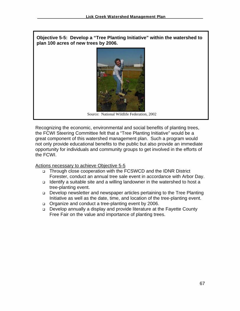
_________________ Lick Creek Watershed Management Plan_______________
Objective 5-5: Develop a “Tree Planting Initiative” within the watershed to plan 100 acres of new trees by 2006.
Source: National Wildlife Federation, 2002
Recognizing the economic, environmental and social benefits of planting trees, the FCWI Steering Committee felt that a “Tree Planting Initiative” would be a great component of this watershed management plan. Such a program would not only provide educational benefits to the public but also provide an immediate opportunity for individuals and community groups to get involved in the efforts of the FCWI. Actions necessary to achieve Objective 5-5
Through close cooperation with the FCSWCD and the IDNR District Forester, conduct an annual tree sale event in accordance with Arbor Day.
Identify a suitable site and a willing landowner in the watershed to host a tree-planting event.
Develop newsletter and newspaper articles pertaining to the Tree Planting Initiative as well as the date, time, and location of the tree-planting event.
Organize and conduct a tree-planting event by 2006. Develop annually a display and provide literature at the Fayette County
Free Fair on the value and importance of planting trees.
67

_________________ Lick Creek Watershed Management Plan_______________
Objective 5-6: Increase enrollment in the IDNR’s Classified Forest Program from 293 acres (38%) to 586 acres (77%) by 2007.
Source: IDNR, 2003
The Classified Forest program is specifically designed to help keep Indiana's private forests intact. It allows landowners with at least 10 acres of forest to set it aside and to remain as forest. In return for meeting program guidelines landowners receive property tax breaks, forestry literature and periodic free inspections by a professional forester while the forest is enrolled in the program. The Indiana Classified Forest program is one of the most successful and longest running forest stewardship programs in the United States. Currently over 8,300 pieces of property, covering nearly 410,000 acres, are enrolled in this voluntary set aside program. And, the program is growing in excess of 10,000 acres per year (IDNR, 2003). Utilizing the District Forester’s Classified Forest Program database, the watershed coordination team incorporated Lick Creek’s current Classified Forest enrollment into a Geographic Information System (GIS). There are currently 293 acres enrolled in the Classified Forest Program within the watershed (Figure 5-2). 68
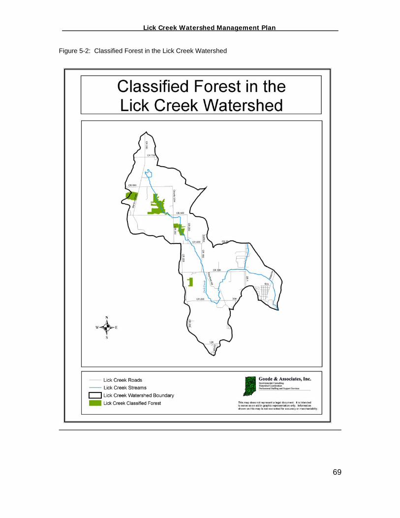
_________________ Lick Creek Watershed Management Plan_______________
Figure 5-2: Classified Forest in the Lick Creek Watershed
69
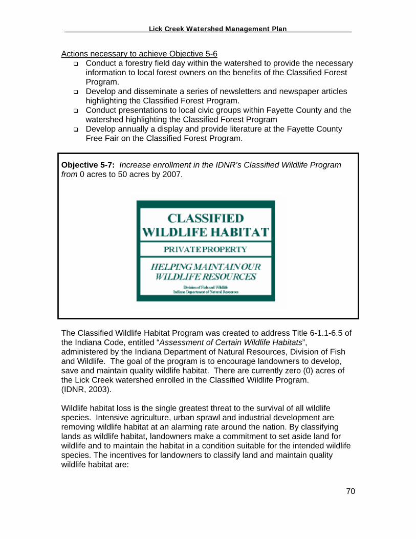
_________________ Lick Creek Watershed Management Plan_______________
Actions necessary to achieve Objective 5-6 Conduct a forestry field day within the watershed to provide the necessary
information to local forest owners on the benefits of the Classified Forest Program.
Develop and disseminate a series of newsletters and newspaper articles highlighting the Classified Forest Program.
Conduct presentations to local civic groups within Fayette County and the watershed highlighting the Classified Forest Program
Develop annually a display and provide literature at the Fayette County Free Fair on the Classified Forest Program.
Objective 5-7: Increase enrollment in the IDNR’s Classified Wildlife Program from 0 acres to 50 acres by 2007.
The Classified Wildlife Habitat Program was created to address Title 6-1.1-6.5 of the Indiana Code, entitled “Assessment of Certain Wildlife Habitats”, administered by the Indiana Department of Natural Resources, Division of Fish and Wildlife. The goal of the program is to encourage landowners to develop, save and maintain quality wildlife habitat. There are currently zero (0) acres of the Lick Creek watershed enrolled in the Classified Wildlife Program. (IDNR, 2003). Wildlife habitat loss is the single greatest threat to the survival of all wildlife species. Intensive agriculture, urban sprawl and industrial development are removing wildlife habitat at an alarming rate around the nation. By classifying lands as wildlife habitat, landowners make a commitment to set aside land for wildlife and to maintain the habitat in a condition suitable for the intended wildlife species. The incentives for landowners to classify land and maintain quality wildlife habitat are:
70
_________________ Lick Creek Watershed Management Plan_______________
1. The reduction of the assessed value of classified lands to $1 per acre for property tax purposes,
2. The development of a wildlife management plan specifically tailored to meet the habitat and management needs of the wildlife species of interest, and;
3. Free technical advice and assistance. The owner of classified wildlife lands does not relinquish ownership or control of his property, and the Division of Fish and Wildlife does not become connected in any way with the ownership of the land. Classified lands are assessed at $1 per acre for property tax purposes, and property taxes are paid on that assessment. Ditch assessment, because of legal drain status, must be paid in full. Classified lands must be protected from fire, cropping, mowing, and grazing by domestic livestock. These practices may be used on classified areas for the purpose of maintaining wildlife habitat if specifically detailed in the wildlife management plan or specified in a special permit issued by the Division of Fish and Wildlife (IDNR, 2003). Actions necessary to achieve Objective 5-7
Conduct a forestry field day within the watershed to provide the necessary information to local forest owners on the benefits of the Classified Wildlife Program.
Develop and disseminate a series of newsletters and newspaper articles highlighting the Classified Wildlife Program.
Conduct presentations to local civic groups within Fayette County and the watershed highlighting the Classified Wildlife Program
Develop annually a display and provide literature at the Fayette County Free Fair on the Classified Wildlife Program.
71
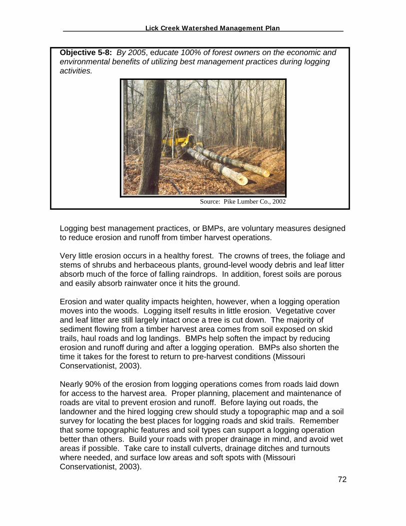
_________________ Lick Creek Watershed Management Plan_______________
Objective 5-8: By 2005, educate 100% of forest owners on the economic and environmental benefits of utilizing best management practices during logging activities.
Source: Pike Lumber Co., 2002
Logging best management practices, or BMPs, are voluntary measures designed to reduce erosion and runoff from timber harvest operations. Very little erosion occurs in a healthy forest. The crowns of trees, the foliage and stems of shrubs and herbaceous plants, ground-level woody debris and leaf litter absorb much of the force of falling raindrops. In addition, forest soils are porous and easily absorb rainwater once it hits the ground. Erosion and water quality impacts heighten, however, when a logging operation moves into the woods. Logging itself results in little erosion. Vegetative cover and leaf litter are still largely intact once a tree is cut down. The majority of sediment flowing from a timber harvest area comes from soil exposed on skid trails, haul roads and log landings. BMPs help soften the impact by reducing erosion and runoff during and after a logging operation. BMPs also shorten the time it takes for the forest to return to pre-harvest conditions (Missouri Conservationist, 2003). Nearly 90% of the erosion from logging operations comes from roads laid down for access to the harvest area. Proper planning, placement and maintenance of roads are vital to prevent erosion and runoff. Before laying out roads, the landowner and the hired logging crew should study a topographic map and a soil survey for locating the best places for logging roads and skid trails. Remember that some topographic features and soil types can support a logging operation better than others. Build your roads with proper drainage in mind, and avoid wet areas if possible. Take care to install culverts, drainage ditches and turnouts where needed, and surface low areas and soft spots with (Missouri Conservationist, 2003). 72
_________________ Lick Creek Watershed Management Plan_______________
Actions Necessary to Achieve Objective 5-8 Conduct a forestry field day within the watershed to provide the necessary
information to local forest owners on and logging professionals on the benefits of utilizing BMPs while harvesting timber.
Conduct a training course for logging professionals on the utilization of BMPs.
Develop and disseminate a series of newsletters and newspaper articles highlighting the importance of utilizing BMPs while harvesting timber.
Conduct presentations to local civic groups within Fayette County and the watershed highlighting the importance of utilizing BMPs while harvesting timber.
Develop annually a display and provide literature at the Fayette County Free Fair on the value and importance of utilizing BMPs while harvesting timber.
Responsible Parties for Implementing Objectives 5-1 thru 5-8 The CEC’s Environmental Educator will work closely with the IDNR District Forester and the FCSWCD staff on fulfilling Objectives 5-2 thru 5-8. The Environmental Educator will be responsible for developing newsletters and newspaper articles, conducting presentations to civic groups, organizing the forestry field day and the tree planting event, and working with the FCSWCD on orchestrating a Tree Sale. The Environmental Educator will be expected to solicit as much participation from other community groups and organizations as possible to foster the necessary partnerships essential to the success of the FCWI. Objective 5-1 will require participation and collaboration of a variety of entities including the Fayette County Commissioners, the Fayette County Council and the Area Plan Commission. Modifying zoning regulations, though supported by the Fayette County Watershed Initiative, goes above and beyond what the FCWI Steering Committee is capable of accomplishing without support and action from a variety of agencies. The FCWI would be no more than a resource if such actions were to take place. Measuring the Success of Objectives 5-1 thru 5-8 The CEC’s Environmental Educator will work closely with the IDNR District Forester and the FCSWCD staff to measure the progress of the Objectives 5-2 thru 5-8. The Environmental Educator will perform the following activities and present a summary of his/her activities at the FCWI quarterly meetings:
Document any changes to local zoning ordinances and any discussions had with political figures on the topic.
Document the number of participants at forestry field day and tree planting events,
Document new acres enrolled in the IDNR Classified Forest Program and Classified Wildlife Program,
73
_________________ Lick Creek Watershed Management Plan_______________
Document and make available all forestry related newsletter and newspaper articles published and disseminated,
Develop and maintain a monthly log of forestry related activities specific to the Lick Creek watershed and make available to the FCWI Steering Committee,
Document, when available, landowners actively participating in TSI as a result of this project.
Objective 5-1 will simply be measured by monitoring whether or not zoning regulations are modified in a manner consistent with protection sensitive areas, including forested lands.
74
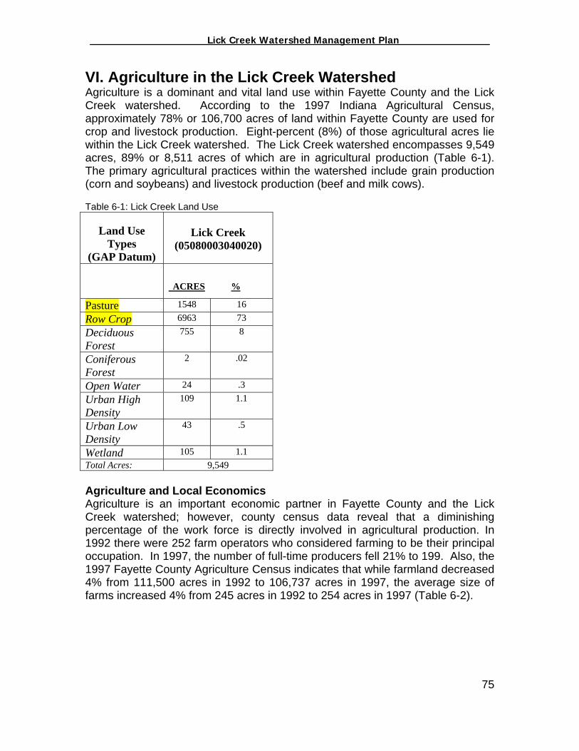
_________________ Lick Creek Watershed Management Plan_______________
VI. Agriculture in the Lick Creek Watershed Agriculture is a dominant and vital land use within Fayette County and the Lick Creek watershed. According to the 1997 Indiana Agricultural Census, approximately 78% or 106,700 acres of land within Fayette County are used for crop and livestock production. Eight-percent (8%) of those agricultural acres lie within the Lick Creek watershed. The Lick Creek watershed encompasses 9,549 acres, 89% or 8,511 acres of which are in agricultural production (Table 6-1). The primary agricultural practices within the watershed include grain production (corn and soybeans) and livestock production (beef and milk cows). Table 6-1: Lick Creek Land Use
Land Use Types
(GAP Datum)
Lick Creek
(05080003040020)
ACRES %
Pasture 1548 16 Row Crop 6963 73 Deciduous Forest
755 8
Coniferous Forest
2 .02
Open Water 24 .3 Urban High Density
109 1.1
Urban Low Density
43 .5
Wetland 105 1.1 Total Acres: 9,549 Agriculture and Local Economics Agriculture is an important economic partner in Fayette County and the Lick Creek watershed; however, county census data reveal that a diminishing percentage of the work force is directly involved in agricultural production. In 1992 there were 252 farm operators who considered farming to be their principal occupation. In 1997, the number of full-time producers fell 21% to 199. Also, the 1997 Fayette County Agriculture Census indicates that while farmland decreased 4% from 111,500 acres in 1992 to 106,737 acres in 1997, the average size of farms increased 4% from 245 acres in 1992 to 254 acres in 1997 (Table 6-2).
75
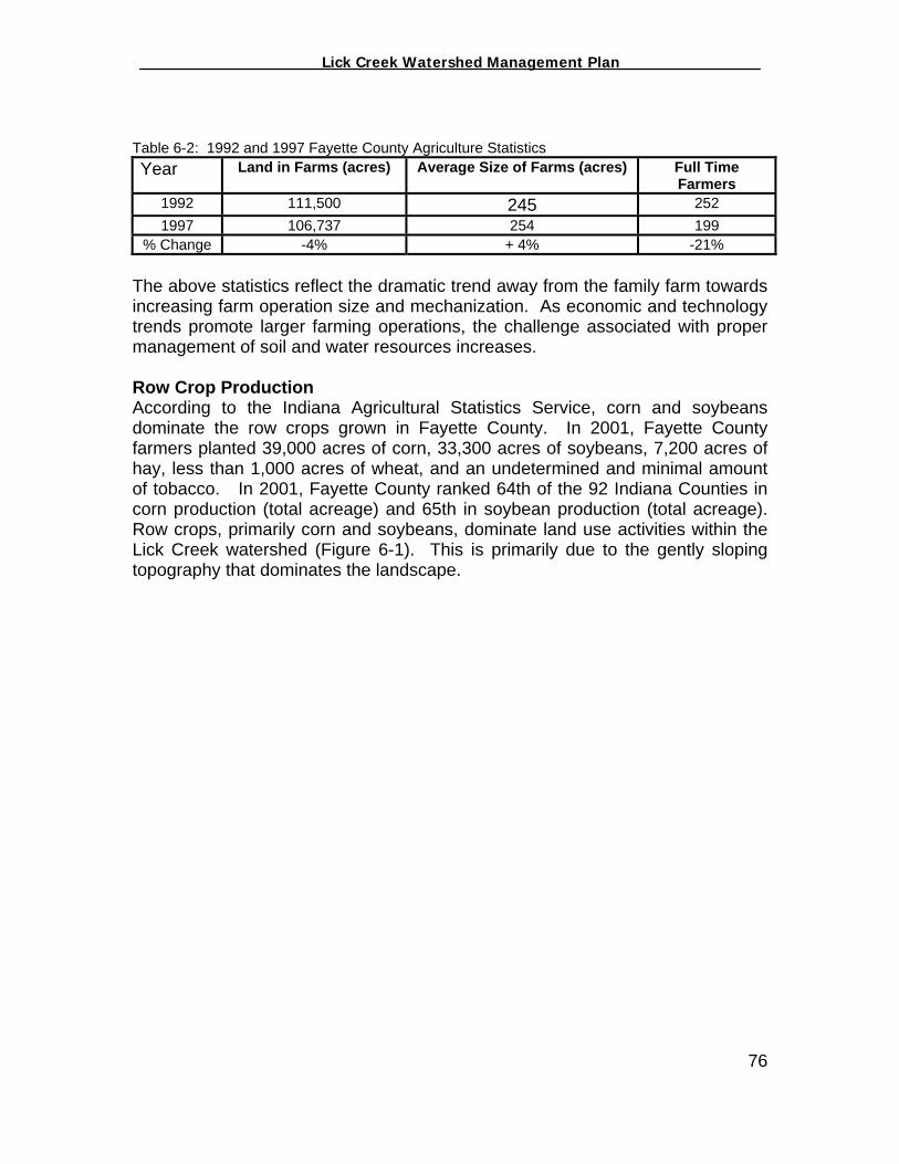
_________________ Lick Creek Watershed Management Plan_______________
Table 6-2: 1992 and 1997 Fayette County Agriculture Statistics Year Land in Farms (acres) Average Size of Farms (acres) Full Time
Farmers 1992 111,500 245 252 1997 106,737 254 199
% Change -4% + 4% -21% The above statistics reflect the dramatic trend away from the family farm towards increasing farm operation size and mechanization. As economic and technology trends promote larger farming operations, the challenge associated with proper management of soil and water resources increases. Row Crop Production According to the Indiana Agricultural Statistics Service, corn and soybeans dominate the row crops grown in Fayette County. In 2001, Fayette County farmers planted 39,000 acres of corn, 33,300 acres of soybeans, 7,200 acres of hay, less than 1,000 acres of wheat, and an undetermined and minimal amount of tobacco. In 2001, Fayette County ranked 64th of the 92 Indiana Counties in corn production (total acreage) and 65th in soybean production (total acreage). Row crops, primarily corn and soybeans, dominate land use activities within the Lick Creek watershed (Figure 6-1). This is primarily due to the gently sloping topography that dominates the landscape.
76
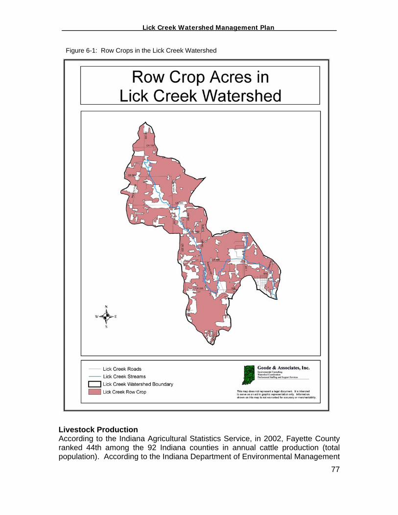
_________________ Lick Creek Watershed Management Plan_______________
Figure 6-1: Row Crops in the Lick Creek Watershed
Livestock Production According to the Indiana Agricultural Statistics Service, in 2002, Fayette County ranked 44th among the 92 Indiana counties in annual cattle production (total population). According to the Indiana Department of Environmental Management 77
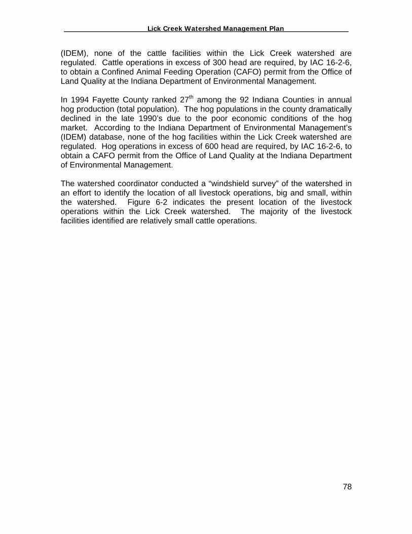
_________________ Lick Creek Watershed Management Plan_______________
(IDEM), none of the cattle facilities within the Lick Creek watershed are regulated. Cattle operations in excess of 300 head are required, by IAC 16-2-6, to obtain a Confined Animal Feeding Operation (CAFO) permit from the Office of Land Quality at the Indiana Department of Environmental Management. In 1994 Fayette County ranked 27th among the 92 Indiana Counties in annual hog production (total population). The hog populations in the county dramatically declined in the late 1990’s due to the poor economic conditions of the hog market. According to the Indiana Department of Environmental Management’s (IDEM) database, none of the hog facilities within the Lick Creek watershed are regulated. Hog operations in excess of 600 head are required, by IAC 16-2-6, to obtain a CAFO permit from the Office of Land Quality at the Indiana Department of Environmental Management. The watershed coordinator conducted a “windshield survey” of the watershed in an effort to identify the location of all livestock operations, big and small, within the watershed. Figure 6-2 indicates the present location of the livestock operations within the Lick Creek watershed. The majority of the livestock facilities identified are relatively small cattle operations.
78
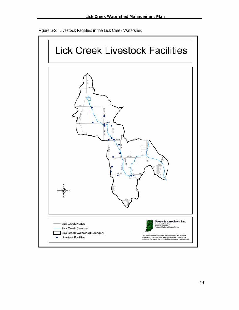
_________________ Lick Creek Watershed Management Plan_______________
Figure 6-2: Livestock Facilities in the Lick Creek Watershed
79

_________________ Lick Creek Watershed Management Plan_______________
Agriculture on Highly Erodible Soils According to the Fayette County Soil Survey, approximately 1,119 acres or 12% of the agricultural lands within the watershed are located on soils considered to be highly erodible. The highly erodible soils, identified in the soil survey as Highly Erodible Lands (HEL), found within the Lick Creek watershed are identified below in Table 6-3. Table 6-3: Highly Erodible Lands (HEL) in the Fayette County Lick Creek Watershed
Map Unit Symbol
Soil
Name
% Slope
CcC1 Cincinnati 8 CcC2 Cincinnati 9 CcD1 Cincinnati 14 CcD2 Cincinnati 15 CcE1 Cincinnati 22 CcE2 Cincinnati 22 CcF2 Cincinnati 30 CnC3 Cincinnati 8 CdD3 Cincinnati 14 CnE3 Cincinnati 20 FaB Fairmount 4 FaC Fairmount 8 FaD Fairmount 15 FaE Fairmount 22 FaF Fairmount 30 FaG Fairmount 45
FmC2 Fox 8 FnC2 Fox 8 FnD1 Fox 14 FnD2 Fox 15 FoC2 Fox 8 FpC3 Fox 8 FrC3 Fox 8 FsD2 Fox/Rodman 15 FtD2 Fox/Rodman 15 FtE2 Fox/Rodman 22 FvD3 Fox/Rodman 15 FxD3 Fox/Rodman 15 HeF1 Hennepin 30 HeF2 Hennepin 30 HeG1 Hennepin 40 HeG2 Hennepin 40 McC2 Martinsville 8 McD2 Martinsville 14 MmC1 Miami 8 MmC2 Miami 8
80
_________________ Lick Creek Watershed Management Plan_______________
MmD1 Miami 15 MmD2 Miami 15
MmE1 Miami 21 MmE2 Miami 21 MsC3 Miami 8 MsD3 Miami 15 MsE3 Miami 20 OcC2 Ockley 8 OkC3 Ockley 8 RgD2 Russell 15 RgE1 Russell 20 RgE2 Russell 20 RgF2 Russell 30 RsC1 Russell 8 RsC2 Russell 8 RsD1 Russell 15 RsD2 Russell 15 RsE1 Russell 22 RsE2 Russell 22 RtC3 Russell 8 RtD3 Russell 15 RtE3 Russell 22 RuC1 Russell/Miami 8 RuC2 Russell/Miami 8 RvC3 Russell/Miami 8 WnC2 Wynn 8 WnD2 Wynn 18 WyC3 Wynn 8
81

_________________ Lick Creek Watershed Management Plan_______________
Figure 6-3: Highly Erodible Soils on Agricultural Lands
82

_________________ Lick Creek Watershed Management Plan_______________
Fayette County Tillage Practices According to the IDNR County Tillage Report, 31% of the corn and 68% of the soybeans grown in Fayette County are grown utilizing a conservation tillage system (Figure 6-4). Conservation tillage is defined as any tillage system leaving greater than 30% crop residue cover after planting. Figure 6-4: 2002 Tillage Statistics for Fayette County
Assuming the countywide statistics above are representative of the Lick Creek watershed, it is estimated that 2,284 acres of soybeans and 1,042 acres of corn are annually planted utilizing a conservation tillage system. Agriculture and Water Quality Generally speaking, agriculture has been identified as one of the major contributors of nonpoint source pollution in rural landscapes around the United States. In 1997, the National Water Quality Inventory (NWQI), sponsored by the US EPA reported that agricultural nonpoint source (NPS) pollution is the leading source of water quality impacts to surveyed rivers and lakes, the third largest source of impairments to surveyed estuaries, and a major contributor to ground water contamination and wetlands degradation (EPA, 2000). Potential NPS pollutants stemming from agriculture in the Lick Creek watershed include nutrients, chemicals, sediment, and bacteria (see Table 6-4). Such
83

_________________ Lick Creek Watershed Management Plan_______________
pollutants can migrate from agricultural lands to surface and groundwater through processes including surface runoff, erosion, infiltration, direct deposit, and drainage tile outlet. Table 6-4: NPS and Agriculture
Pollutants Agriculture Sources Nutrients commercial fertilizers and manure Chemicals herbicides, insecticides, fungicides Sediment sheet, rill, gully, and stream bank erosion Bacteria manure Nutrients In the Lick Creek watershed, nutrients such as phosphorus (P) and nitrogen (N) in the form of commercial fertilizers and manure are applied to enhance crop production. In small amounts, N and P are beneficial to aquatic life, however, too much P and N can stimulate the occurrence of algal blooms and excessive plant growth in receiving waters (see Figure 6-7). Algal blooms and excessive plant growth often reduce the dissolved oxygen content of surface waters through plant respiration and decomposition of dead algae and other plants. This situation can be accelerated in hot weather and low flow conditions because of the reduced capacity of the water to retain dissolved oxygen. Since fish and aquatic insects need the oxygen that is dissolved in water to live, when decaying algae uses up that oxygen, fish kills can result. It is important to note that there are no documented occurrences of fish kills within Lick Creek. Figure 6-5: Ammonia/Nitrogen Application Figure 6-6: Livestock in Lick Creek
Source: USDA/NRCS, 2003
84
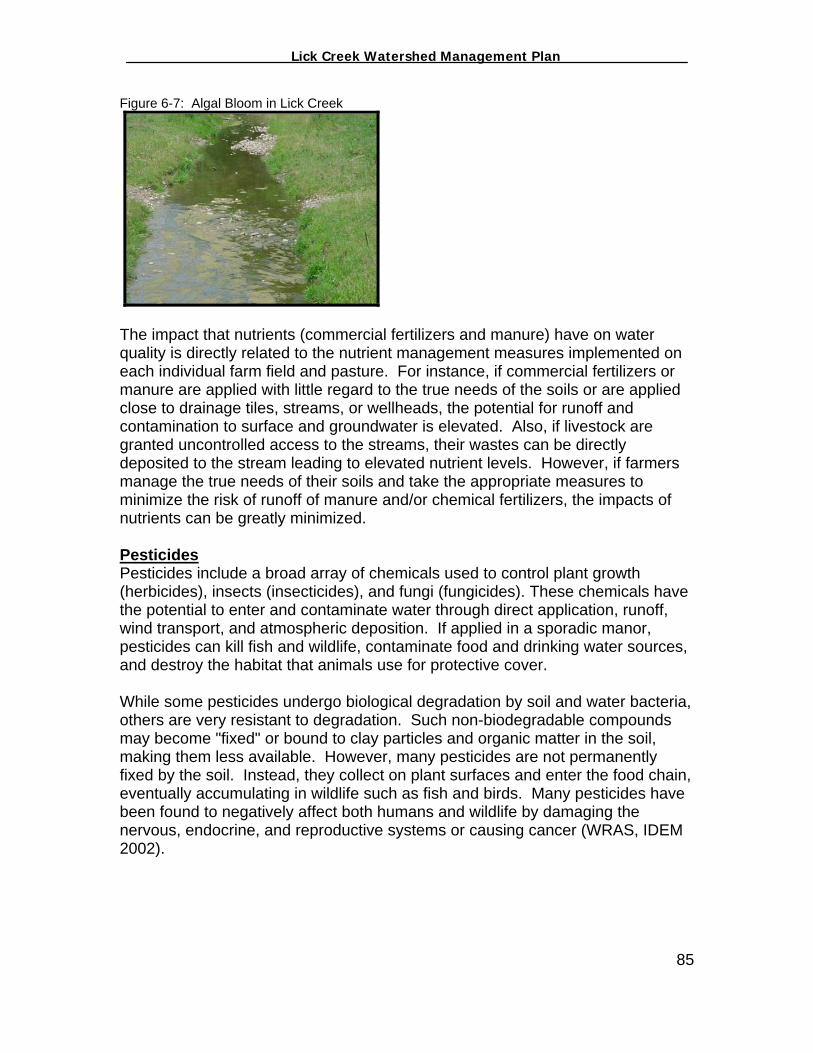
_________________ Lick Creek Watershed Management Plan_______________
Figure 6-7: Algal Bloom in Lick Creek
The impact that nutrients (commercial fertilizers and manure) have on water quality is directly related to the nutrient management measures implemented on each individual farm field and pasture. For instance, if commercial fertilizers or manure are applied with little regard to the true needs of the soils or are applied close to drainage tiles, streams, or wellheads, the potential for runoff and contamination to surface and groundwater is elevated. Also, if livestock are granted uncontrolled access to the streams, their wastes can be directly deposited to the stream leading to elevated nutrient levels. However, if farmers manage the true needs of their soils and take the appropriate measures to minimize the risk of runoff of manure and/or chemical fertilizers, the impacts of nutrients can be greatly minimized. Pesticides Pesticides include a broad array of chemicals used to control plant growth (herbicides), insects (insecticides), and fungi (fungicides). These chemicals have the potential to enter and contaminate water through direct application, runoff, wind transport, and atmospheric deposition. If applied in a sporadic manor, pesticides can kill fish and wildlife, contaminate food and drinking water sources, and destroy the habitat that animals use for protective cover. While some pesticides undergo biological degradation by soil and water bacteria, others are very resistant to degradation. Such non-biodegradable compounds may become "fixed" or bound to clay particles and organic matter in the soil, making them less available. However, many pesticides are not permanently fixed by the soil. Instead, they collect on plant surfaces and enter the food chain, eventually accumulating in wildlife such as fish and birds. Many pesticides have been found to negatively affect both humans and wildlife by damaging the nervous, endocrine, and reproductive systems or causing cancer (WRAS, IDEM 2002).
85

_________________ Lick Creek Watershed Management Plan_______________
Figure 6-8: Pesticide Application
Erosion and Sedimentation Sedimentation occurs when wind or water runoff carries soil particles from an area, such as a farm field or stream bank, and transports them to a water body, such as Lick Creek. Excessive sedimentation clouds the water covering fish spawning areas and food supplies while clogging the gills of fish. In addition, other pollutants like phosphorus, pathogens, and heavy metals are often attached to the soil particles and wind up in the water with the sediment. Common field erosion in the Lick Creek watershed occurs in the following forms: gully erosion, sheet erosion, and rill erosion (see Figure 6-9) Figure 6-9: Sheet and Gully Erosion
If livestock are allowed uncontrolled access to streams, severe bank erosion can result (Figure 6-10). This can lead to loss of topsoil, sediment-laden waters as well as an increase of livestock fecal matter inputs.
86

_________________ Lick Creek Watershed Management Plan_______________
Figure 6-10: Streambank erosion resulting from livestock
Bacteria Livestock production has been identified nationwide as a major contributor of Escheri Coli (E. coli) to surface and groundwater supplies. E.coli bacteria live within the intestinal tract of warm-blooded animals. E.coli is widely used as an indicator of sewage pollution, which may harbor additional waterborne disease causing (pathogenic) bacteria, protozoa, and viruses. E.coli is also used as an indicator because it is easier and less costly to monitor and detect than the actual pathogenic organisms, such as Giardia, Cryptosporidium, and Shigella, which require special sampling protocols and very sophisticated laboratory techniques. The presence of these waterborne disease-causing organisms can cause outbreaks of diseases, such as typhoid fever, dysentery, cholera, and cryptosporidiosis. Water quality standards (WQS) for E.coli have been established in order to ensure safe use of waters for drinking water supplies and recreation. Indiana Code, 327 IAC 2-1-6 Section 6(d), states that E.coli bacteria, using membrane filter count (MF), shall not exceed 125 per 100 milliliters as a geometric mean based on not less than five samples equally spaced over a 30 day period nor exceed 235 per 100 mL in any one sample in a 30-day period. As discussed in Section III, E.coli monitoring by the FCWI Watershed Coordinator identified several locations within Lick Creek where the WQS for E.coli was violated during this project. It is believed that livestock facilities may have an impact on the high E. coli levels within the Lick Creek watershed. Agricultural Goals and Decisions The ultimate goal of the FCWI Steering Committee, from an agricultural perspective, is to increase the utilization of Best Management Practices (BMPs) on all agricultural lands. The FCWI Steering Committee recognizes and values 87
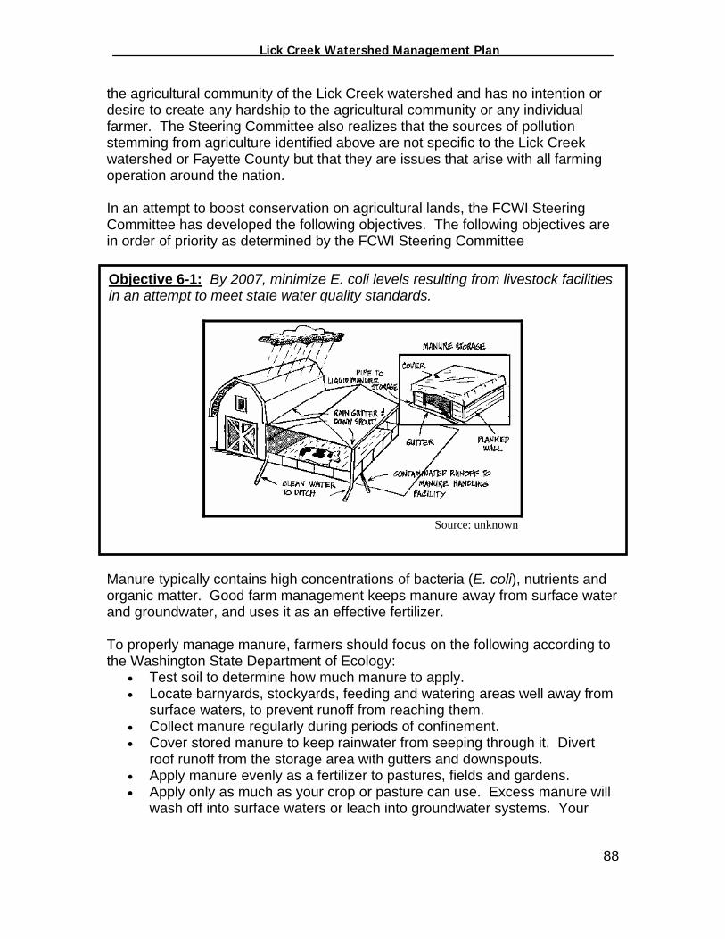
_________________ Lick Creek Watershed Management Plan_______________
the agricultural community of the Lick Creek watershed and has no intention or desire to create any hardship to the agricultural community or any individual farmer. The Steering Committee also realizes that the sources of pollution stemming from agriculture identified above are not specific to the Lick Creek watershed or Fayette County but that they are issues that arise with all farming operation around the nation. In an attempt to boost conservation on agricultural lands, the FCWI Steering Committee has developed the following objectives. The following objectives are in order of priority as determined by the FCWI Steering Committee
Objective 6-1: By 2007, minimize E. coli levels resulting from livestock facilities in an attempt to meet state water quality standards.
Source: unknown
Manure typically contains high concentrations of bacteria (E. coli), nutrients and organic matter. Good farm management keeps manure away from surface water and groundwater, and uses it as an effective fertilizer. To properly manage manure, farmers should focus on the following according to the Washington State Department of Ecology:
• Test soil to determine how much manure to apply. • Locate barnyards, stockyards, feeding and watering areas well away from
surface waters, to prevent runoff from reaching them. • Collect manure regularly during periods of confinement. • Cover stored manure to keep rainwater from seeping through it. Divert
roof runoff from the storage area with gutters and downspouts. • Apply manure evenly as a fertilizer to pastures, fields and gardens. • Apply only as much as your crop or pasture can use. Excess manure will
wash off into surface waters or leach into groundwater systems. Your
88
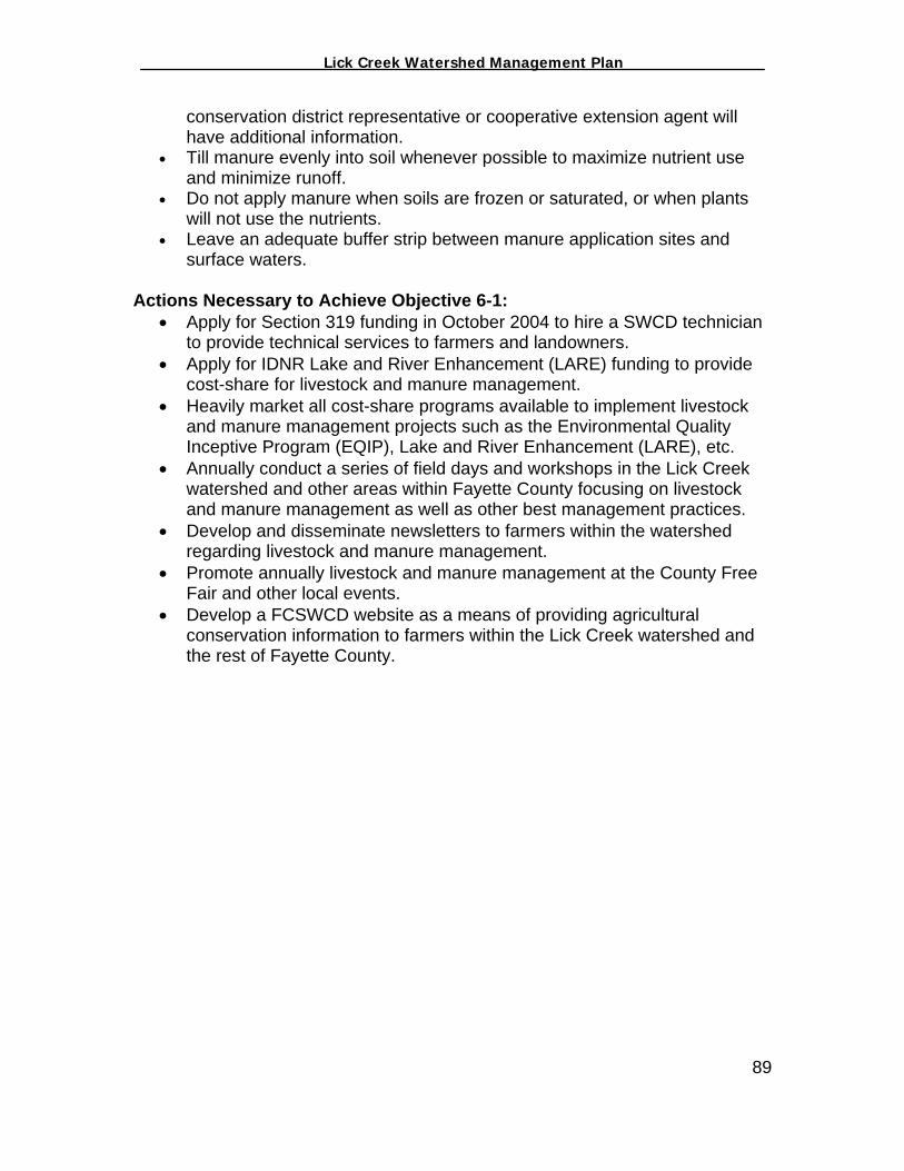
_________________ Lick Creek Watershed Management Plan_______________
conservation district representative or cooperative extension agent will have additional information.
• Till manure evenly into soil whenever possible to maximize nutrient use and minimize runoff.
• Do not apply manure when soils are frozen or saturated, or when plants will not use the nutrients.
• Leave an adequate buffer strip between manure application sites and surface waters.
Actions Necessary to Achieve Objective 6-1:
• Apply for Section 319 funding in October 2004 to hire a SWCD technician to provide technical services to farmers and landowners.
• Apply for IDNR Lake and River Enhancement (LARE) funding to provide cost-share for livestock and manure management.
• Heavily market all cost-share programs available to implement livestock and manure management projects such as the Environmental Quality Inceptive Program (EQIP), Lake and River Enhancement (LARE), etc.
• Annually conduct a series of field days and workshops in the Lick Creek watershed and other areas within Fayette County focusing on livestock and manure management as well as other best management practices.
• Develop and disseminate newsletters to farmers within the watershed regarding livestock and manure management.
• Promote annually livestock and manure management at the County Free Fair and other local events.
• Develop a FCSWCD website as a means of providing agricultural conservation information to farmers within the Lick Creek watershed and the rest of Fayette County.
89

_________________ Lick Creek Watershed Management Plan_______________
Objective 6-2: By 2007, educate 100% of livestock producers on the water quality impacts associated with granting livestock unlimited access to the creek.
Source: Washington State University, 2003 Trampling by livestock erodes streambanks. Runoff carrying manure can contribute to the pollution of surface and groundwater. To minimize the impacts livestock may have on water quality, a livestock farmer should consider the following:
• Restrict livestock and barnyard animals from streamside areas with fencing. Hedges are attractive living fences that attract wild birds and other beneficial wildlife.
• Establish watering and feeding areas for animals away from slopes leading to waterbodies.
• Avoid excessive runoff through proper pasture management and land-clearing practices.
• If animals must be watered at streamside, use a ramp-fence system (see diagram above).
Actions Necessary to Objective 6-2:
• Apply for Section 319 funding in October 2004 to hire a SWCD technician to provide technical services to farmers and landowners.
• Conduct a series of field days and workshops in the Lick Creek watershed focusing on livestock management.
• Develop and disseminate newsletters to farmers within the watershed regarding livestock management and the available cost-share dollars to implement livestock management practices.
• Provide technical assistance to agriculture producers on the economic and environmental benefits of livestock management.
• Promote annually livestock management at the County Free Fair and other local events.
• Apply for Lake and River Enhancement (LARE) funding to provide cost-share for livestock management.
90
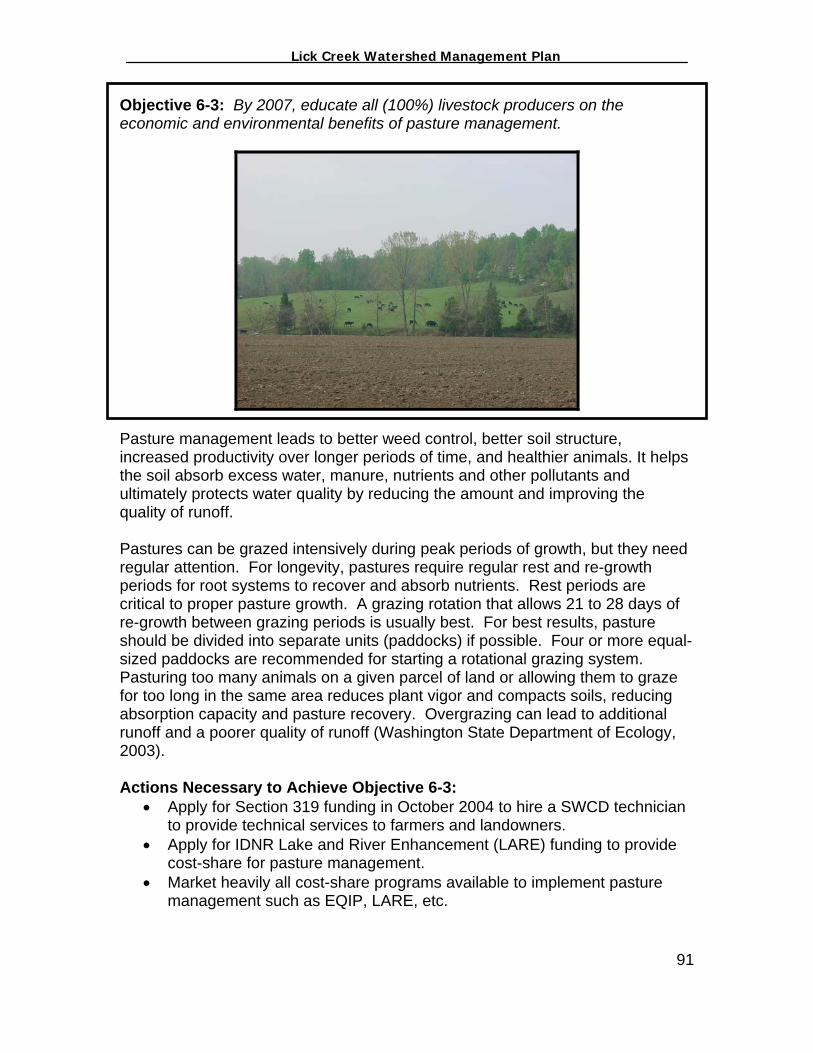
_________________ Lick Creek Watershed Management Plan_______________
Objective 6-3: By 2007, educate all (100%) livestock producers on the economic and environmental benefits of pasture management.
Pasture management leads to better weed control, better soil structure, increased productivity over longer periods of time, and healthier animals. It helps the soil absorb excess water, manure, nutrients and other pollutants and ultimately protects water quality by reducing the amount and improving the quality of runoff. Pastures can be grazed intensively during peak periods of growth, but they need regular attention. For longevity, pastures require regular rest and re-growth periods for root systems to recover and absorb nutrients. Rest periods are critical to proper pasture growth. A grazing rotation that allows 21 to 28 days of re-growth between grazing periods is usually best. For best results, pasture should be divided into separate units (paddocks) if possible. Four or more equal-sized paddocks are recommended for starting a rotational grazing system. Pasturing too many animals on a given parcel of land or allowing them to graze for too long in the same area reduces plant vigor and compacts soils, reducing absorption capacity and pasture recovery. Overgrazing can lead to additional runoff and a poorer quality of runoff (Washington State Department of Ecology, 2003). Actions Necessary to Achieve Objective 6-3:
• Apply for Section 319 funding in October 2004 to hire a SWCD technician to provide technical services to farmers and landowners.
• Apply for IDNR Lake and River Enhancement (LARE) funding to provide cost-share for pasture management.
• Market heavily all cost-share programs available to implement pasture management such as EQIP, LARE, etc.
91

_________________ Lick Creek Watershed Management Plan_______________
• Conduct annually a series of field days and workshops in the Lick Creek watershed and other areas within Fayette County focusing on pasture management and other best management practices.
• Develop and disseminate newsletters to farmers within the watershed regarding pasture management and the available cost-share dollars to implement pasture management.
• Promote annually pasture management at the County Free Fair and other local events.
Objective 6-4: By 2007, increase the utilization of conservation tillage by 50% Soybeans: 2,284 (68%) to 3,426 acres (98%) Corn: 1,042 acres (31%) to 1,563 acres (45%)
Source: USDA/NRCS, 2003
According to the Conservation Tillage Information Center (CTIC), there are numerous economic and environmental benefits that conservation tillage offers that conventional tillage systems cannot match. The top benefits, as identified by the CTIC web site (www.ctic.purdue.edu), are as follows:
Reduces labor, saves time As little as one trip for planting compared to two or more tillage operations means fewer hours on a tractor and fewer labor hours to pay ... or more acres to farm. For instance, on 500 acres the time savings can be as much as 225 hours per year. That’s almost four 60-hour weeks.
Saves fuel Save an average 3.5 gallons an acre or 1,750 gallons on a 500-acre farm.
Reduces machinery wear Fewer trips save an estimated $5 per acre on machinery wear and maintenance costs—a $2,500 savings on a 500-acre farm.
92
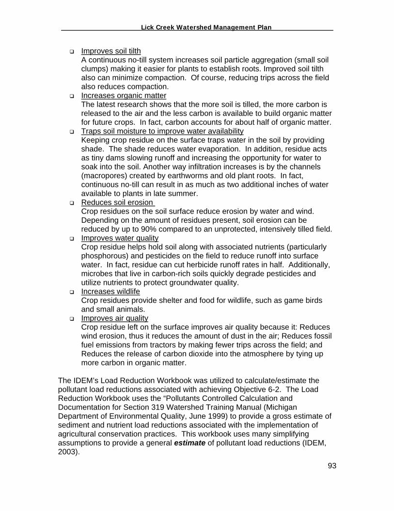
_________________ Lick Creek Watershed Management Plan_______________
Improves soil tilth A continuous no-till system increases soil particle aggregation (small soil clumps) making it easier for plants to establish roots. Improved soil tilth also can minimize compaction. Of course, reducing trips across the field also reduces compaction.
Increases organic matter The latest research shows that the more soil is tilled, the more carbon is released to the air and the less carbon is available to build organic matter for future crops. In fact, carbon accounts for about half of organic matter.
Traps soil moisture to improve water availability Keeping crop residue on the surface traps water in the soil by providing shade. The shade reduces water evaporation. In addition, residue acts as tiny dams slowing runoff and increasing the opportunity for water to soak into the soil. Another way infiltration increases is by the channels (macropores) created by earthworms and old plant roots. In fact, continuous no-till can result in as much as two additional inches of water available to plants in late summer.
Reduces soil erosion Crop residues on the soil surface reduce erosion by water and wind. Depending on the amount of residues present, soil erosion can be reduced by up to 90% compared to an unprotected, intensively tilled field.
Improves water quality Crop residue helps hold soil along with associated nutrients (particularly phosphorous) and pesticides on the field to reduce runoff into surface water. In fact, residue can cut herbicide runoff rates in half. Additionally, microbes that live in carbon-rich soils quickly degrade pesticides and utilize nutrients to protect groundwater quality.
Increases wildlife Crop residues provide shelter and food for wildlife, such as game birds and small animals.
Improves air quality Crop residue left on the surface improves air quality because it: Reduces wind erosion, thus it reduces the amount of dust in the air; Reduces fossil fuel emissions from tractors by making fewer trips across the field; and Reduces the release of carbon dioxide into the atmosphere by tying up more carbon in organic matter.
The IDEM’s Load Reduction Workbook was utilized to calculate/estimate the pollutant load reductions associated with achieving Objective 6-2. The Load Reduction Workbook uses the “Pollutants Controlled Calculation and Documentation for Section 319 Watershed Training Manual (Michigan Department of Environmental Quality, June 1999) to provide a gross estimate of sediment and nutrient load reductions associated with the implementation of agricultural conservation practices. This workbook uses many simplifying assumptions to provide a general estimate of pollutant load reductions (IDEM, 2003).
93
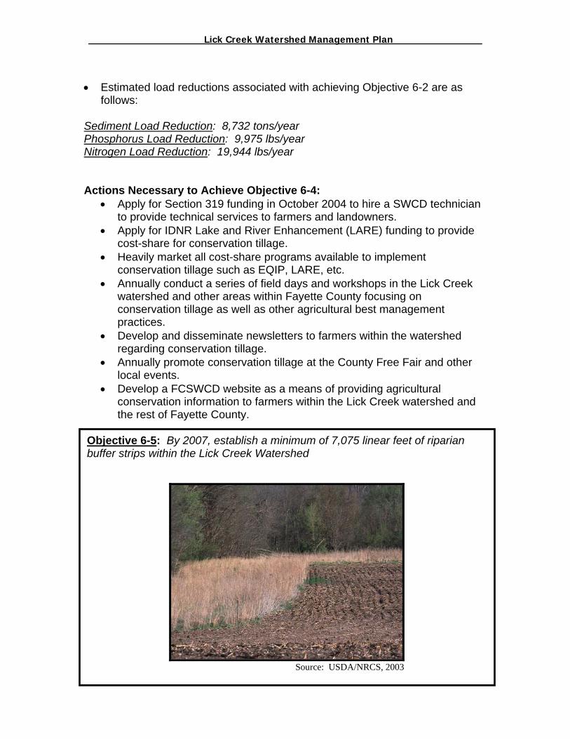
_________________ Lick Creek Watershed Management Plan_______________
• Estimated load reductions associated with achieving Objective 6-2 are as
follows: Sediment Load Reduction: 8,732 tons/year Phosphorus Load Reduction: 9 975 lbs/year Nitrogen Load Reduction: 19,9 Actions Necessary to Achiev
• Apply for Section 319 futo provide technical serv
• Apply for IDNR Lake ancost-share for conservat
• Heavily market all cost-sconservation tillage such
• Annually conduct a seriewatershed and other areconservation tillage as wpractices.
• Develop and disseminatregarding conservation t
• Annually promote conselocal events.
• Develop a FCSWCD weconservation informationthe rest of Fayette Coun
Objective 6-5: By 2007, estabuffer strips within the Lick Cre
,
44 lbs/yeare Objective 6-4: nding in October 2004 to hire a SWCD technician ices to farmers and landowners.
d River Enhancement (LARE) funding to provide ion tillage. hare programs available to implement as EQIP, LARE, etc. s of field days and workshops in the Lick Creek as within Fayette County focusing on ell as other agricultural best management
e newsletters to farmers within the watershed illage. rvation tillage at the County Free Fair and other
bsite as a means of providing agricultural to farmers within the Lick Creek watershed and ty.
94
blish a minimum of 7,075 linear feet of riparian ek Watershed
Source: USDA/NRCS, 2003

_________________ Lick Creek Watershed Management Plan_______________
Conservation buffers are small areas or strips of land in permanent vegetation, designed to slow water runoff, provide shelter and stabilize riparian areas. Strategically placed buffer strips in the agricultural landscape can effectively mitigate the movement of sediment, nutrients, and pesticides from farm fields. Conservation buffers include: contour buffer strips, field borders, filter strips, grassed waterways, living snow fences, riparian buffers, shelterbelts/windbreaks (grass, shrubs and trees), and wetlands. The small amount of land taken out of production helps producers meet environmental and economic goals. Benefits of Conservation Buffers The economic and environmental benefits of conservation buffers, as identified by the CTIC website (www.ctic.purdue.edu), are as follows:
Reduces up to 80% of sediment from runoff. Reduces 40% (on average) of phosphorous from runoff. Removes a significant amount of nitrate from runoff. Removes up to 60% of pathogens from runoff. Provides a source of food, nesting cover and shelter for wildlife. Improves fish habitat. Reduces wind erosion. Slows water runoff. Reduces downstream flooding. Stabilizes streambanks. Establish natural vegetation. Adds visual aesthetics to the landscape. Protects soil in vulnerable areas.
The Watershed Coordinator, utilizing 1998 aerial photography and GIS software, identified 17,803 feet of potential buffer projects within the Lick Creek watershed (Figure 6-13). Realizing that there is a margin of error with the method used to identify these sites, the FCWI Steering Committee realize that an agricultural conservation specialist needs to visit each site identified to determine the true needs of each site. The IDEM’s Load Reduction Workbook was utilized to calculate/estimate the pollutant load reductions associated with achieving Objective 6-3 assuming that the buffer strips were, at a minimum, 20 feet wide. The Load Reduction Workbook uses the “Pollutants Controlled Calculation and Documentation for Section 319 Watershed Training Manual (Michigan Department of Environmental Quality, June 1999) to provide a gross estimate of sediment and nutrient load reductions associated with the implementation of agricultural conservation practices. This workbook uses many simplifying assumptions to provide a general estimate of pollutant load reductions (IDEM, 2003). • Estimated Load Reductions associated with Objective 6-3 are as follows: Sediment Load Reduction: 19 tons/year
95
_________________ Lick Creek Watershed Management Plan_______________
Phosphorus Load Reduction: 21 lbs/year Nitrogen Load Reduction: 41 lbs/year Actions Necessary to Achieve Objective 6-5:
• Apply for Section 319 funding in October 2004 to hire a SWCD technician to provide technical services to farmers and landowners.
• Apply for IDNR Lake and River Enhancement (LARE) funding to provide cost-share for conservation buffer projects.
• Heavily market all cost-share programs available to implement livestock and manure management projects such as EQIP, CRP, WHIP, LARE, etc.
• Annually conduct a series of field days and workshops in the Lick Creek watershed and other areas within Fayette County focusing on conservation buffers as well as other best management practices.
• Develop and disseminate newsletters to farmers within the watershed regarding conservation buffers.
• Annually promote conservation buffers at the County Free Fair and other local events.
• Develop a FCSWCD website as a means of providing agricultural conservation information to farmers within the Lick Creek watershed and the rest of Fayette County.
96

_________________ Lick Creek Watershed Management Plan_______________
Figure 6-13: Potential Buffer Projects
97

_________________ Lick Creek Watershed Management Plan_______________
Objective 6-6: By 2007, educate 100% of farmers within the watershed on the economic and environmental benefits of nutrient management.
Source: USDA/NRCS, 2003
Nutrient management is another important component to a sound on-farm management system to minimize the impacts that fertilizers and manure have on water quality. According to the Conservation Tillage Information Center at Purdue University, there are ten (10) fundamental components of a Crop Nutrient Management Plan. Each component is critical to helping a farmer analyze each field and improve nutrient efficiency for the crops grown while protecting water quality. The following components were derived from CTIC web site (www.ctic.purdue.edu):
o Field map. For improved planning purposes, field maps should include general reference points such as streams, residences, wellheads, number of acres, soil types, etc.
o Soil test. Soil tests should be conducted on a consistent schedule to analyze the true nutrient needs of individual fields. The photo in Objective 6-4 shows a farmer testing his soils and marking his sample points utilizing a Global Positioning System (GPS).
o Crop sequence. The crops grown and the management practices utilized in the past should all be considered when making nutrient management related decisions.
o Estimated yield. Historic yields are important in developing yield estimates for next year. Accurate yield estimates can dramatically improve nutrient use efficiency.
o Sources and forms. The sources and forms of available nutrients can vary from farm-to-farm and even field-to-field (manure, legumes, etc.).
o Sensitive areas. The physical characteristics of the field should be considered when developing a nutrient management plan. One
98

_________________ Lick Creek Watershed Management Plan_______________
should pay considerable attention to whether or not there are conditions present that could increase or decrease the risk of nutrient loading to water bodies (streams, lakes, drainage ditches, sandy soils, wellheads, buffer strips)
o Recommended rates. Recommended rates involve the proper amount and location of applied fertilizer.
o Recommended timing. There are numerous variables involved with the proper timing of fertilizer application (temperature, moisture, tillage practice, whether or not a starter fertilizer will be used, etc.) Taking all variables into consideration will provide a benefit to your nutrient management program.
o Recommended methods. There are different methods to properly apply fertilizer and manure. Slope, rainfall patterns, soil type, crop rotation and many other factors affect which method is best for optimizing nutrient efficiency. These things should all be considered on a field-by-field basis.
o Annual review and update. Keeping good notes throughout the season and annually reviewing the nutrient program can provide great benefit to an operation. Documenting the weather patterns, crop diseases, yields, what fertilizer was applied and how much fertilizer was applied can help a farmer understand how his/her soils respond under different conditions.
Actions Necessary to Achieve Objective 6-6:
• Apply for Section 319 funding in October 2004 to hire a SWCD technician to provide technical services to farmers and landowners.
• Apply for IDNR Lake and River Enhancement (LARE) funding to provide cost-share for nutrient management.
• Market heavily all cost-share programs available to implement nutrient management such as EQIP, LARE, etc.
• Conduct annually a series of field days and workshops in the Lick Creek watershed and other areas within Fayette County focusing on nutrient management as well as other best management practices.
• Develop and disseminate newsletters to farmers within the watershed regarding nutrient management.
• Promote annually nutrient management at the County Free Fair and other local events.
99
• Develop an FCSWCD website as a means of providing agricultural conservation information to farmers within the Lick Creek watershed and the rest of Fayette County.
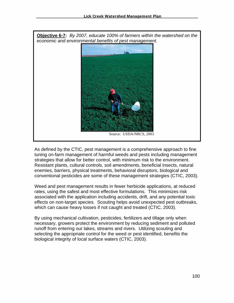
_________________ Lick Creek Watershed Management Plan_______________
Objective 6-7: By 2007, educate 100% of farmers within the watershed on the economic and environmental benefits of pest management.
Source: USDA/NRCS, 2003
As defined by the CTIC, pest management is a comprehensive approach to fine tuning on-farm management of harmful weeds and pests including management strategies that allow for better control, with minimum risk to the environment. Resistant plants, cultural controls, soil amendments, beneficial insects, natural enemies, barriers, physical treatments, behavioral disruptors, biological and conventional pesticides are some of these management strategies (CTIC, 2003). Weed and pest management results in fewer herbicide applications, at reduced rates, using the safest and most effective formulations. This minimizes risk associated with the application including accidents, drift, and any potential toxic effects on non-target species. Scouting helps avoid unexpected pest outbreaks, which can cause heavy losses if not caught and treated (CTIC, 2003). By using mechanical cultivation, pesticides, fertilizers and tillage only when necessary, growers protect the environment by reducing sediment and polluted runoff from entering our lakes, streams and rivers. Utilizing scouting and selecting the appropriate control for the weed or pest identified, benefits the biological integrity of local surface waters (CTIC, 2003).
100
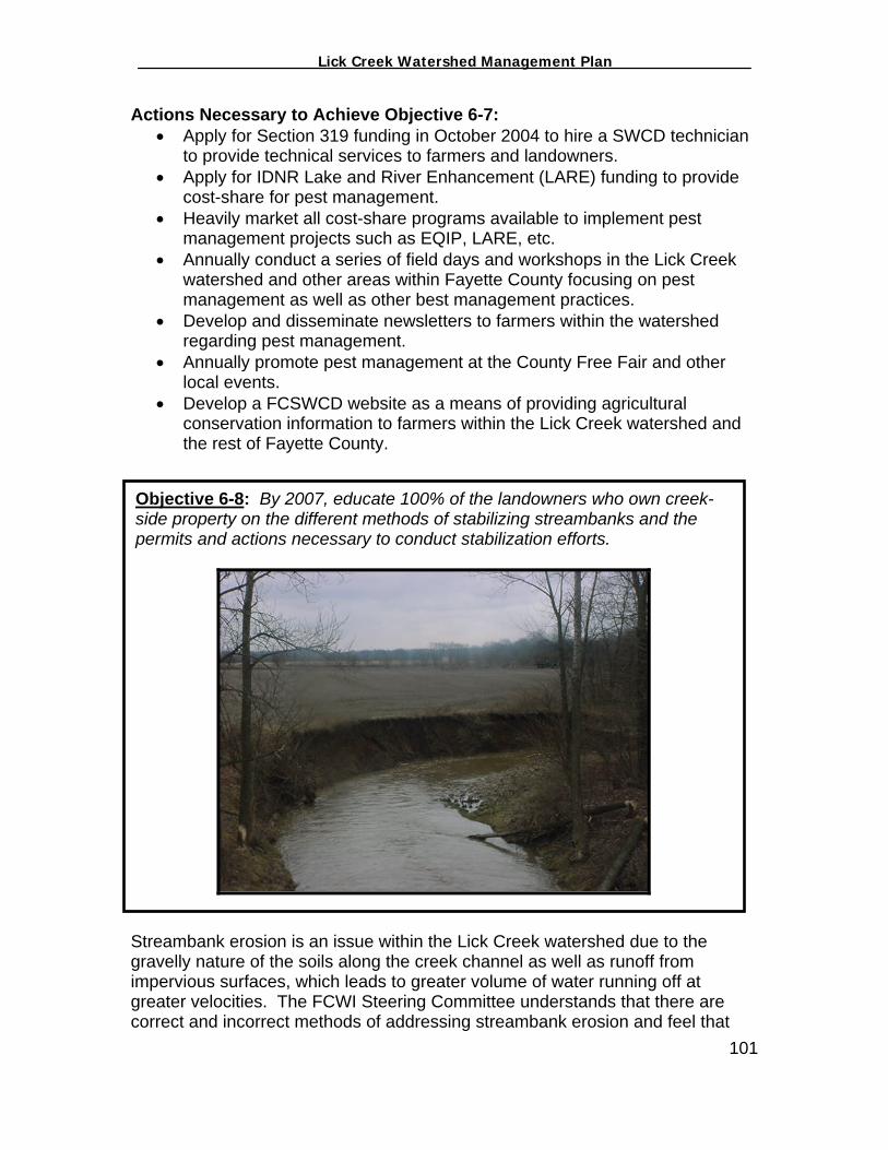
_________________ Lick Creek Watershed Management Plan_______________
Actions Necessary to Achieve Objective 6-7: • Apply for Section 319 funding in October 2004 to hire a SWCD technician
to provide technical services to farmers and landowners. • Apply for IDNR Lake and River Enhancement (LARE) funding to provide
cost-share for pest management. • Heavily market all cost-share programs available to implement pest
management projects such as EQIP, LARE, etc. • Annually conduct a series of field days and workshops in the Lick Creek
watershed and other areas within Fayette County focusing on pest management as well as other best management practices.
• Develop and disseminate newsletters to farmers within the watershed regarding pest management.
• Annually promote pest management at the County Free Fair and other local events.
• Develop a FCSWCD website as a means of providing agricultural conservation information to farmers within the Lick Creek watershed and the rest of Fayette County.
Objective 6-8: By 2007, educate 100% of the landowners who own creek-side property on the different methods of stabilizing streambanks and the permits and actions necessary to conduct stabilization efforts.
Streambank erosion is an issue within the Lick Creek watershed due to the gravelly nature of the soils along the creek channel as well as runoff from impervious surfaces, which leads to greater volume of water running off at greater velocities. The FCWI Steering Committee understands that there are correct and incorrect methods of addressing streambank erosion and feel that 101

_________________ Lick Creek Watershed Management Plan_______________
educating landowners and governmental agencies is a necessity for addressing the streambank erosion problem within the watershed. Actions Necessary to Achieve Objective 6-8:
• Apply for Section 319 funding in October 2004 to hire a SWCD technician to provide technical services to farmers and landowners.
• Apply for IDNR Lake and River Enhancement (LARE) funding to provide cost-share for stream stabilization projects.
• Market heavily all cost-share programs available to implement stream stabilization projects such as CRP, LARE, etc.
• In 2005, organize and conduct a tour of stabilized streambanks in neighboring counties where good examples exist.
• Develop and disseminate newsletters to farmers within the watershed regarding proper streambank stabilization and the laws and regulations involved with streambank stabilization.
• Promote annually proper streambank protection at the County Free Fair and other local events.
• Develop an FCSWCD website as a means of providing agricultural conservation information to farmers within the Lick Creek watershed and the rest of Fayette County.
Objective 6-9: By 2007, educate 100% of farmers and landowners on the USDA Wetland Reserve Program (WRP) and the Wildlife Habitat Incentive Program (WHIP) and the value of protecting wildlife habitat.
Wildlife habitats, including wetlands, support an abundant and diverse population of plant and animal species, many of which are currently rare or endangered. Through their unique soils and vegetation, wetlands and other vegetated habitats
102
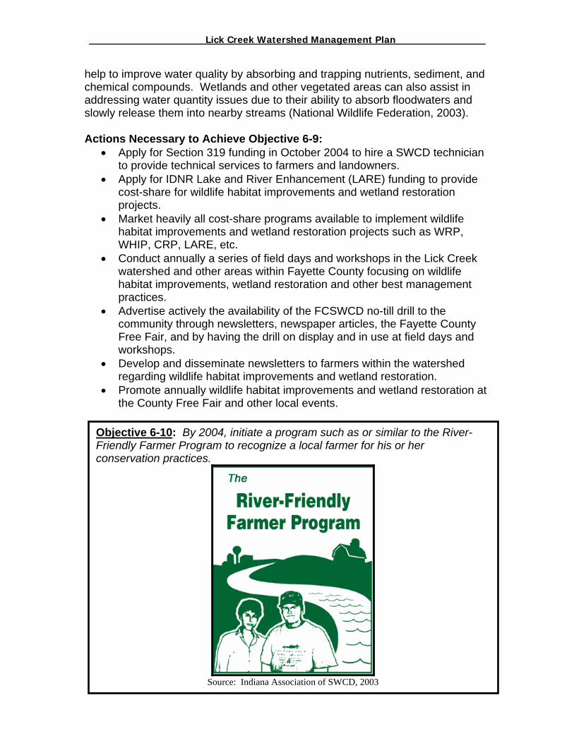
_________________ Lick Creek Watershed Management Plan_______________
help to improve water quality by absorbing and trapping nutrients, sediment, and chemical compounds. Wetlands and other vegetated areas can also assist in addressing water quantity issues due to their ability to absorb floodwaters and slowly release them into nearby streams (National Wildlife Federation, 2003). Actions Necessary to Achieve Objective 6-9:
• Apply for Section 319 funding in October 2004 to hire a SWCD technician to provide technical services to farmers and landowners.
• Apply for IDNR Lake and River Enhancement (LARE) funding to provide cost-share for wildlife habitat improvements and wetland restoration projects.
• Market heavily all cost-share programs available to implement wildlife habitat improvements and wetland restoration projects such as WRP, WHIP, CRP, LARE, etc.
• Conduct annually a series of field days and workshops in the Lick Creek watershed and other areas within Fayette County focusing on wildlife habitat improvements, wetland restoration and other best management practices.
• Advertise actively the availability of the FCSWCD no-till drill to the community through newsletters, newspaper articles, the Fayette County Free Fair, and by having the drill on display and in use at field days and workshops.
• Develop and disseminate newsletters to farmers within the watershed regarding wildlife habitat improvements and wetland restoration.
• Promote annually wildlife habitat improvements and wetland restoration at the County Free Fair and other local events.
103
Objective 6-10: By 2004, initiate a program such as or similar to the River-Friendly Farmer Program to recognize a local farmer for his or her conservation practices.
Source: Indiana Association of SWCD, 2003

_________________ Lick Creek Watershed Management Plan_______________
The FCWI Steering Committee feels that those farmers who are actively participating in conservation efforts should be recognized for their efforts. The FCWI Steering Committee feels that the local SWCD Annual Dinner is the prime opportunity to acknowledge those farmers who have been good stewards of the land. Actions Necessary to Achieve Objective 6-10:
• Develop the criteria for which a farmer must satisfy to be eligible for the award.
• Develop a team or committee to review nominations for this award • Advertise the program through Fayette County Farm Bureau, the
Connersville News Examiner, FCSWCD Newsletters and other local means.
• Purchase and present the award at the Annual FCSWCD Meetings.
Objective 6-11: Educate all (100%) of livestock producers of the water quality/forest impacts related to granting livestock access to forestland.
Source: USDA/NRCS, 2003
Excluding livestock from forestland helps preserve the integrity of woodlands. Cattle hooves crush, chop and destroy the duff layer and leaf litter on the forest floor, increasing the likelihood of erosion during periods of heavy rain. The reduction of soil exposes tree roots, allowing hooves to damage root surfaces. These "open wounds" invite invasions of fungi, insects and bacteria that can damage tree health and greatly reduce the market value of the timber (Missouri Conservationist, 2003). Actions Necessary to Achieve Objective 6-11:
• Apply for Section 319 funding in October 2004 to hire a SWCD technician to provide technical services to farmers and landowners.
104
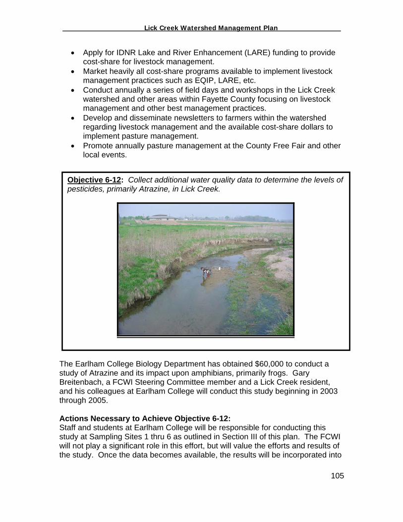
_________________ Lick Creek Watershed Management Plan_______________
• Apply for IDNR Lake and River Enhancement (LARE) funding to provide cost-share for livestock management.
• Market heavily all cost-share programs available to implement livestock management practices such as EQIP, LARE, etc.
• Conduct annually a series of field days and workshops in the Lick Creek watershed and other areas within Fayette County focusing on livestock management and other best management practices.
• Develop and disseminate newsletters to farmers within the watershed regarding livestock management and the available cost-share dollars to implement pasture management.
• Promote annually pasture management at the County Free Fair and other local events.
Objective 6-12: Collect additional water quality data to determine the levels of pesticides, primarily Atrazine, in Lick Creek.
The Earlham College Biology Department has obtained $60,000 to conduct a study of Atrazine and its impact upon amphibians, primarily frogs. Gary Breitenbach, a FCWI Steering Committee member and a Lick Creek resident, and his colleagues at Earlham College will conduct this study beginning in 2003 through 2005. Actions Necessary to Achieve Objective 6-12: Staff and students at Earlham College will be responsible for conducting this study at Sampling Sites 1 thru 6 as outlined in Section III of this plan. The FCWI will not play a significant role in this effort, but will value the efforts and results of the study. Once the data becomes available, the results will be incorporated into
105

_________________ Lick Creek Watershed Management Plan_______________
the Lick Creek watershed management plan and, if necessary, goals and actions pertaining to the data will be developed. Responsible Partners for Implementing Objectives 6-1 thru 6-12: Because they play a direct role in agricultural issues, the FCSWCD and the NRCS have been deemed as the responsible partners for implementing the agricultural related measures discussed in this section. The FCSWCD and the NRCS, however, should rely upon a variety of organizations and agencies for assistance in implementing the agricultural component of this plan. Such parties include: Fayette County Farm Bureau, Purdue Extension, IDNR Division of Soil Conservation, Fayette County 4-H, Future Farmers of America (FFA), the Connersville High School Agriculture Teacher, the Community Education Coalition, the Earlham College Biology Department, and IU East. Measuring the Success of Objectives 6-1 thru 6-12: In order to measure the progress of Objectives 6-1 thru 6-12, staff from the FCSWCD and NRCS will conduct the following activities:
Document all interaction with Lick Creek farmers. Document the attendance at field days and workshops. Utilize GIS to document the location and other specifics of BMP’s
implemented in the Lick Creek watershed. Where applicable, utilize the IDEM’s Load Reduction Workbook to
estimate the load reduction benefits of BMPs implemented. Develop and maintain a monthly log of progress and make available at the
FCWI Quarterly Meetings. Develop a FCSWCD website as a means of providing information to local
farmers regarding agriculture and watershed protection. Critical Agricultural Areas Critical agricultural areas are those target areas within the watershed where the major stressors or potential major stresses originate. The FCWI Steering Committee has identified the following as critical areas or priority areas of the Lick Creek watershed:
All Livestock Facilities within the watershed due to the significant E. coli problems Lick Creek is experiencing (Figure 6-2)
Agricultural operations upon HEL (Figure 6-3) Potential buffer project areas (Figure 6-13) Row Crop acres not under a conservation tillage program All wetlands adjacent to agricultural lands
Funding Necessary to Achieve Objectives 6-1 thru 6-12: There are a wide variety of state and federal funding programs available to implement agricultural conservation practices. The FCWI Steering Committee, in cooperation with the FCSWCD, will explore and promote all funding mechanisms available in an attempt to increase agricultural conservation practices within the watershed. Such funding mechanisms include:
106
_________________ Lick Creek Watershed Management Plan_______________
Environmental Quality Incentives Program Administered: USDA/NRCS Summary: Funding for projects to treat identified soil, water and related natural resource concerns on eligible land. Technical, financial and educational support are available. Half of which is targeted towards livestock related concerns and half of it toward general conservation. Eligibility: Non-federal landowners engaged in livestock operations or agricultural productions. How Much: Up to $10,000 per person per year and up to $50,000 over the length of a contract. Federal cost share support of up to 75%. Web Pages/Links: http://www.nrcs.usda.gov/programs/eqip/ Conservation Reserve Program Administered: USDA/ Indiana Farm Service Agency Summary: Funding for projects to control soil erosion. The goal of the program is to give farmers incentives to convert highly erodible land or other sensitive areas into vegetative cover such as native grasses, trees, and riparian buffers. Eligibility: Agricultural land owners How Much: Annual rental payments for the term of a multi year contract of up to $50,000 per fiscal year. Funds are also available for up to 50% of cost of establishing vegetative cover. Web Pages/Links: http://www.fsa.usda.gov/dafp/cepd/crp.htm Wetland Reserve Program Administered: USDA/NRCS Summary: Program provides technical and financial assistance to land owners restoring marginal agricultural land to wetland. Easements range from 10-30 years. Landowners retain ownership. Eligibility: Land owners who have owned their land for at least 12 months. How Much: NRCS easement and restoration payments range from 75% - 100% Web pages and Links: http://www.nhq.nrcs.usda.gov/PROGRAMS/wrp/ Wildlife Habitat Incentive Program Administered: USDA/NRCS Summary: Cost share and technical assistance to develop and improve wildlife habitat on private land. Eligibility: Private landowners who are agricultural producers are eligible How Much: 75% Federal Cost Share Web Pages/Links: http://www.nhq.nrcs.usda.gov/PROGRAMS/whip/ Lake and River Enhancement Program Administered: Indiana DNR
107

_________________ Lick Creek Watershed Management Plan_______________
Summary: Funding to reduce inflow of sediments and nutrients into lakes and rivers. Eligible projects include water quality monitoring and watershed projects. Eligibility: Local entities, land planners, and development organizations. How Much: Financial assistance of up to $100,000 is available. Program also provides up to 80% cost share of approved watershed land treatment practices. Web Pages and Links: http://www.in.gov/dnr/soilcons/pdfs/lare.pdf http://www.in.gov/dnr/soilcons Non Point Source Implementation Grants (319) Administered: EPA/IDEM Summary: Projects to control nonpoint source pollution are eligible. Funds can be used for TMDL development and implementation, watershed management plans, education programs and more. Eligibility: Non-profit groups, universities, municipalities, etc. How Much: Twenty Five percent match with a maximum award of $112,500. Web Pages/Links: http://www.in.gov/idem/water/planbr/wsm/index.html The FCSWCD shall apply for a Section 319 Grant in October of 2004 to obtain funding to hire a watershed technician to provide technical services to local farmers. In addition, the FCSWCD in February 2003 applied for a LARE grant to obtain $60K in cost-share to implement conservation practices upon agricultural lands within the Lick Creek watershed. The result of the LARE grant application is uncertain at this time. 108

_________________ Lick Creek Watershed Management Plan_______________
VII. Septic Systems in the Lick Creek Watershed Because the majority of the Lick Creek watershed lies within rural areas of Fayette County, the majority of the Lick Creek residents rely upon septic systems for on-site wastewater treatment. Properly functioning septic systems provide a natural method of treatment and disposal of household wastes for those homeowners who are not connected to a municipal sewage system. However, a faulty or improperly installed septic system has the potential to create serious groundwater and surface water problems. How Septic Systems Work The septic tank is the first step of the wastewater treatment process. The septic tank is a solid tank designed specifically to accept all wastewater from the home. A septic system works by allowing wastewater to separate into layers and begin the process of decomposition while being contained within the septic tank (Figure 7-1). Bacteria, which are naturally present in all functioning septic systems, begin to digest the solids that have settled to the bottom of the tank, transforming up to 50 percent of these solids into liquids and gases. When liquids within the tank rise to the level of an outflow pipe, they enter the drainage system. This outflow, or effluent, is then distributed throughout a drain field and a series of subsurface pipes. Final treatment of the effluent occurs here as the soil absorbs and filters the liquid and microbes break down the rest of the waste into harmless material (Septic Seep, 2003). Figure 7-1: Components of a Septic Tank
Source: Septic Seep, 2003 In the soil treatment portion of the system (drain field), bacteria and viruses in the sewage are destroyed by the soil and naturally occurring
109

_________________ Lick Creek Watershed Management Plan_______________
microscopic organisms (Figure 7-2). Nutrients are absorbed by soil particles or taken up by plants. Figure 7-2: Drain Field of a Septic System
Source: Septic Seep, 2003 Water Quality and Septic Systems 5. In addition to livestock, septic systems have been identified as major
contributors of E. coli in the Lick Creek watershed (see Section 3). Failing septic systems are not unique to the Lick Creek watershed or to Fayette County. Septic systems tend to be a major problem throughout Indiana and the nation.
Septic tanks/systems can act as sources of nitrogen, phosphorus, organic matter and bacterial (E. coli) and viral pathogens for reasons related to:
Inappropriate installation: This often involves improper site selection for the system due to inadequate separation from groundwater, inadequate absorption area, fractured bedrock, sandy soils, and inadequate soil permeability. Inappropriate installation can also result in the smearing of trench bottoms during construction, compaction of the soil bed by heavy equipment, and improperly performed percolation tests (North Carolina State University, 2003).
According to the 1960 Fayette County Soil Survey, there are numerous soils within Fayette County and the Lick Creek watershed that are not conducive to on-site wastewater treatment. The Watershed Coordination team utilized the Fayette County Soil Survey to develop Figure 7-3 to illustrate which soils in the Lick Creek watershed are considered to be “severely limited” for
110

_________________ Lick Creek Watershed Management Plan_______________
wastewater treatment. Approximately 5,002 acres or 52% of the soils within the watershed fit this category.
Figure 7-3: Severely Limiting Soils for Septic Systems
111

_________________ Lick Creek Watershed Management Plan_______________
Lack of Maintenance: It is estimated that as many as 75 percent of all system failures have been attributed to hydraulic overloading (Storm Water Center, 2003). Regular inspections and maintenance, which are often neglected, are necessary for maintaining the functionality of the system.
In addition to regular maintenance, septic systems, depending on their size, must be purged of all solids that have settled to the bottom of the tank. Pumping frequency depends on the size of the tank and the number of individuals utilizing the system (Objective 7-1). Exhausted lifetime: Septic systems are not designed to last forever but are rarely replaced until well after they have begun to fail. Indiana State Code defines system failure as:
1. The system refuses to accept sewage at the rate of design application thereby interfering with the normal use of plumbing fixtures.
2. Effluent discharge exceeds the absorptive capacity of the soil, resulting in ponding, seepage, or other discharge of the effluent to the ground surface or to surface waters.
3. Effluent is discharged from the system causing contamination of a potable water supply, groundwater, or surface waters.
Straight Pipes: The term “septic system” refers to a septic tank with the
appropriate drain field as described above. However, septic tanks are often installed with a pipe leading directly from the tank to either a drain tile or a stream. This term is often referred to as a “straight pipe” discharge. Essentially, straight pipe systems only provide primary treatment and then release severely polluted wastewater directly to a stream. Straight pipes are a violation of state law and an unhealthy circumstance affecting many streams around that nation. Based upon conversations with the Fayette County Health Department and other stakeholders, it is believed that numerous straight pipes exist within the Lick Creek watershed.
Septic System Goals and Decisions Recognizing the water quality problems associated with failing or inadequate septic systems, the FCWI Steering Committee developed the following objectives. The following objectives are in order of priority as determined by the FCWI Steering Committee.
112
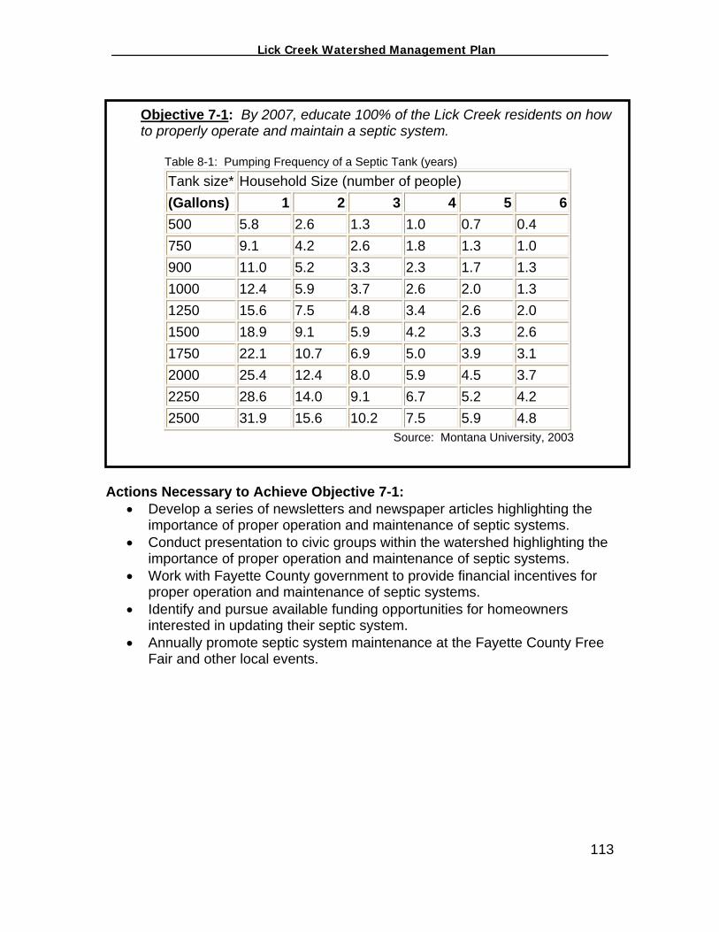
_________________ Lick Creek Watershed Management Plan_______________
Objective 7-1: By 2007, educate 100% of the Lick Creek residents on how to properly operate and maintain a septic system.
Table 8-1: Pumping Frequency of a Septic Tank (years)
Tank size* Household Size (number of people) (Gallons) 1 2 3 4 5 6 500 5.8 2.6 1.3 1.0 0.7 0.4 750 9.1 4.2 2.6 1.8 1.3 1.0 900 11.0 5.2 3.3 2.3 1.7 1.3 1000 12.4 5.9 3.7 2.6 2.0 1.3 1250 15.6 7.5 4.8 3.4 2.6 2.0 1500 18.9 9.1 5.9 4.2 3.3 2.6 1750 22.1 10.7 6.9 5.0 3.9 3.1 2000 25.4 12.4 8.0 5.9 4.5 3.7 2250 28.6 14.0 9.1 6.7 5.2 4.2 2500 31.9 15.6 10.2 7.5 5.9 4.8
Source: Montana University, 2003
Actions Necessary to Achieve Objective 7-1: • Develop a series of newsletters and newspaper articles highlighting the
importance of proper operation and maintenance of septic systems. • Conduct presentation to civic groups within the watershed highlighting the
importance of proper operation and maintenance of septic systems. • Work with Fayette County government to provide financial incentives for
proper operation and maintenance of septic systems. • Identify and pursue available funding opportunities for homeowners
interested in updating their septic system. • Annually promote septic system maintenance at the Fayette County Free
Fair and other local events.
113
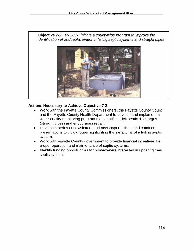
_________________ Lick Creek Watershed Management Plan_______________
Acti•
•
•
•
Objective 7-2: By 2007, initiate a countywide program to improve the identification of and replacement of failing septic systems and straight pipes
ons Necessary to Achieve Objective 7-2: Work with the Fayette County Commissioners, the Fayette County Council
and the Fayette County Health Department to develop and implement a water quality-monitoring program that identifies illicit septic discharges (straight pipes) and encourages repair.
Develop a series of newsletters and newspaper articles and conduct presentations to civic groups highlighting the symptoms of a failing septic system.
Work with Fayette County government to provide financial incentives for proper operation and maintenance of septic systems.
Identify funding opportunities for homeowners interested in updating their septic system.
114
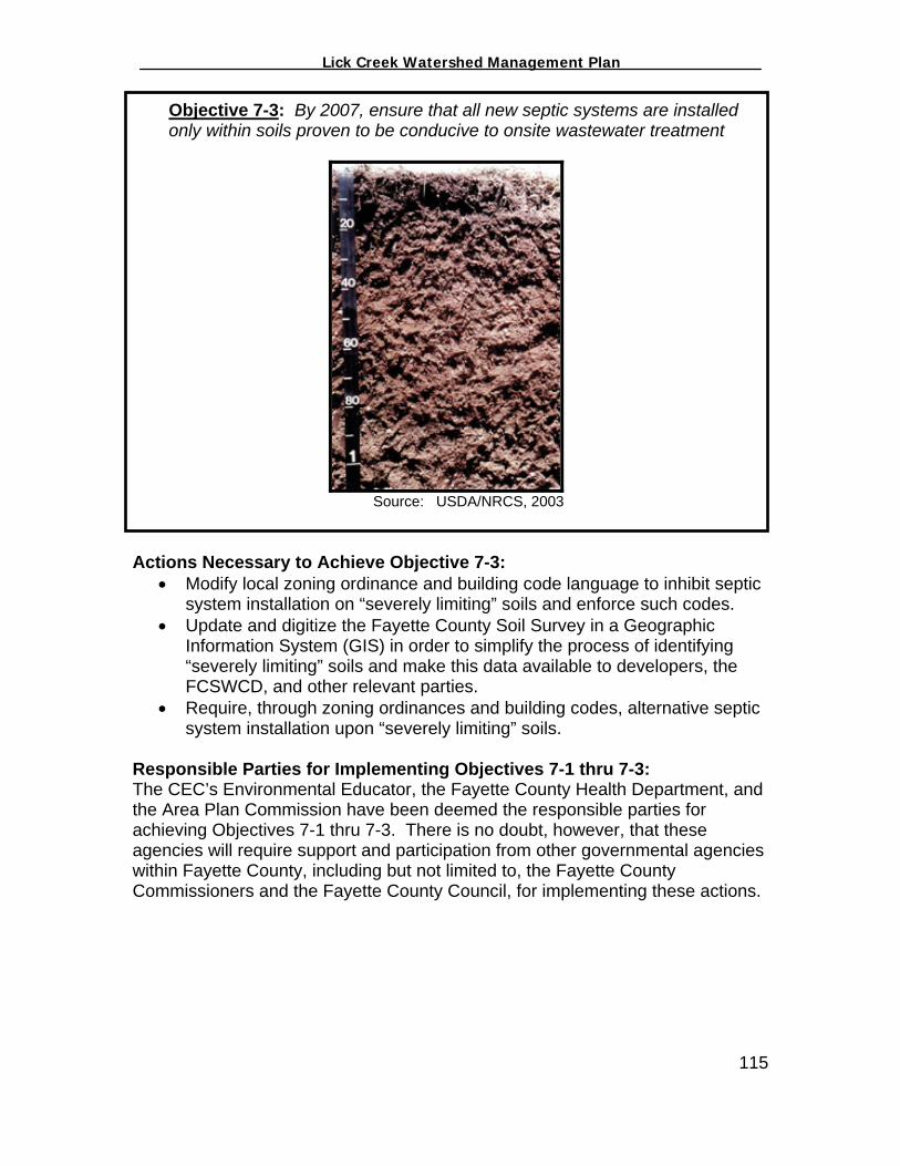
_________________ Lick Creek Watershed Management Plan_______________
Objective 7-3: By 2007, ensure that all new septic systems are installed only within soils proven to be conducive to onsite wastewater treatment
Source: USDA/NRCS, 2003
Actions Necessary to Achieve Objective 7-3: • Modify local zoning ordinance and building code language to inhibit septic
system installation on “severely limiting” soils and enforce such codes. • Update and digitize the Fayette County Soil Survey in a Geographic
Information System (GIS) in order to simplify the process of identifying “severely limiting” soils and make this data available to developers, the FCSWCD, and other relevant parties.
• Require, through zoning ordinances and building codes, alternative septic system installation upon “severely limiting” soils.
Responsible Parties for Implementing Objectives 7-1 thru 7-3: The CEC’s Environmental Educator, the Fayette County Health Department, and the Area Plan Commission have been deemed the responsible parties for achieving Objectives 7-1 thru 7-3. There is no doubt, however, that these agencies will require support and participation from other governmental agencies within Fayette County, including but not limited to, the Fayette County Commissioners and the Fayette County Council, for implementing these actions. 115
_________________ Lick Creek Watershed Management Plan_______________
Measuring the Success of Objectives 7-1 thru 7-3: In order to measure the progress of Objectives 7-1 thru 7-3, staff from the CEC, the Fayette County Health Department, and the Area Plan Commission will conduct the following activities:
Document all associated actions on behalf of the Fayette County Health Department, the Area Plan Commission, the Fayette County Commissioners and the Fayette County Council as they pertain to septic systems, water quality monitoring, economic incentives, and other relevant topics.
Document and make available all septic system related newsletter and newspaper articles published and disseminated by the CEC Environmental Educator to the FCWI Steering Committee at quarterly meetings.
Document all public presentations and the number of residents in attendance, and make this information available to the FCWI Steering Committee at quarterly meetings.
Develop and maintain a monthly log of Fayette County Health Department activities involving septic systems in the Lick Creek watershed, including septic system failures, septic system repairs, and septic system replacement.
Funding Necessary to Achieve Objectives 7-1 thru 7-3: Septic systems are an ongoing problem around the state due to a lack of state and federal funding programs available to address the problem. The Section 319 Grant received by the CEC will fund the education components outline in Objectives 7-1 thru 7-3. However, the other strategies listed above would require county appropriations and collaboration from a variety of governmental offices. Critical Septic System Areas Due to the fact that the majority of the households within the Lick Creek watershed rely upon onsite wastewater treatment and the fact that E. coli is a problem according to the water quality data collected during the development of this plan, each and every septic system in the watershed has been deemed as a priority.
116

_________________ Lick Creek Watershed Management Plan_______________
VIII. Local Government and Watershed Management Numerous local governmental agencies directly or indirectly affect the water quality and natural resources of Lick Creek. Such agencies include:
Fayette County Soil and Water Conservation District (FCSWCD) Fayette County Health Department (FCHD) Area Plan Commission (APC) Fayette County Highway Department Fayette County Surveryor Fayette County Park Board Fayette County Council Fayette County Commissioners Connersville City Utilities
Because of the valuable role each government entity plays directly or indirectly in watershed management, the FCWI Steering Committee felt it necessary to identify these groups, briefly discuss the role each entity plays regarding water quality/natural resources protection and discuss broad and specific actions each entity may take to improve and protect the natural resources of the Lick Creek watershed while furthering the evolution of the Fayette County Watershed Initiative. Many of the needs and objectives discussed below are reiterations of earlier sections but deemed necessary by the FCWI Steering Committee in order for the reader to fully understand the overall complexity of watershed management. Also, many of the needs and objectives discussed below are lofty in the sense that fiscal and political barriers must be overcome to fully satisfy them. Because of the fiscal and political barriers involved, the support and participation of the Fayette County Council, the Fayette County Commissioners and Connersville City government are essential for the success of the FCWI. Though not all of the objectives listed below will require substantial appropriations to complete, many of the agencies will need direction and approval from the council, commissioners and city in order to act upon those objectives. The objectives below are separated in relationship to the organization who would be responsible for implementing such actions. The following objectives for each entity are in order of priority as determined by the FCWI Steering Committee. Fayette County Soil and Water Conservation District (FCSWCD) As discussed previously, the FCSWCD is the agency responsible for the development of this watershed management plan. The FCSWCD, a subdivision of the Indiana Department of Natural Resources (IDNR), is led by a five (5) member Board of Supervisors which manage the day to day activities of one (1) full-time staff member who serves as Administrator and Environmental Educator. Such positions are vital to the functionality of the FCSWCD, however, it is the opinion of the FCWI Steering Committee that the FCSWCD is in need of additional staff with the necessary technical experitise to conduct a wide-variety 117

_________________ Lick Creek Watershed Management Plan_______________
of activities including: agricultural conservation, urban conservation, and erosion and sediment control. Compared to many SWCDs throughout Indiana, the FCSWCD is insufficiently funded at the county level and consequently under staffed and under utilized. Below are the objectives for the FCSWCD developed by the FCWI: Objective 8-1: By 2006, acquire the necessary funding to hire technical SWCD staff including an agricultural specialist and an erosion and sediment control specialist. Objective 8-2: Provide training for local developers, SWCD Supervisors, and other relevant entities on the utilizaiton of erosion and sediment control practices for development projects. Objective 8-3: Educate developers, politicians, and landowners regarding the impacts of unchecked rural development on water quality. Objective 8-4: Develop and maintain a water quality/quantity dialogue between relevant county and city staff by 2006. Fayette County Health Department The Fayette County Health Department (FCHD) is dedicated to protecting the health and wellness of county citizens and safe guarding the environment for use by community members. The FCHD issues permits for residential septic systems and conducts stream and private well monitoring. Monitoring activities are, unfortunately, complaint driven only. Ensuring that septic systems are properly installed is crucial to the quality of local water resources; however, many health departments around the state are also involved in proactive stream and well monitoring to identify specific areas experiencing contamination from septic systems and/or other land use activities. It is the desire of the FCWI Steering Committee that the FCHD develop a proactive stream and well monitoring program while, at the same time, initiating the development of a tax-based incentive program to encourage homeowners to maintain and update their septic systems. The FCWI feels that these two measures combined would lead Fayette County citizens to be more proactive about maintaining and repairing their systems. Below are the objectives for the Fayette County Health Department developed by the FCWI: Objective 8-5: By 2006, acquire the necessary funding to develop a stream and well monitoring program to proactively identify and address the streams of Fayette County suffering from septic system failure and other sources of pollution. Objective 8-6: By 2006, develop an incentive program by which residents are encouraged to maintain, repair and or replace failing or faulty septic systems.
118
_________________ Lick Creek Watershed Management Plan_______________
Objective 8-7: Promote or require the utilization of alternative septic system technologies for developments that occur where soils are non-conducive to wastewater treatment. Objective 8-8: Create sewer and septic districts for non-sewered communities where feasible. Area Plan Commission (APC) The Area Plan Commission is the local body of government authorized to enforce the Planning and Zoning Codes of Fayette County and Connersville, Indiana. The Executive Director of the APC also serves as the Fayette County Building Inspector. The Executive Director of the APC enforces the codes outlined in the 1993 document titled, “Fayette County, Indiana/City of Connersville, Indiana Area Zoning Code, Area Subdivision Control Code, Area Thoroughfare Plan Resolution, Area Comprehensive Plan Resolution, Building Code.” From a water quality perspective, the FCWI Steering Committee has the following desires relating to the APC:
Guide growth and development in Fayette County so it enhances and improves water quality.
Consider the impact land use has on water quality in all planning and zoning decisions.
It is the opinion of the FCWI that the above document is not sufficient in providing water quality protection nor are the measures of this document appropriately enforced. The FCWI Steering Committee is concerned regarding Fayette County’s approch to development as well as the lack of exercise and enforcement of many of the regulations under county code.
Objective 8-9: Implement planning tools to ensure protection and enhancement of natural resources and water quality. Objective 8-10: Update and digitize Fayette County’s soil survey by 2007. Objective 8-11: By 2007, develop and begin utilizing a county-wide GIS system to identify natural areas, sensitive areas, prime agricultural lands (including forested land), non-prime agricultural lands, soils suitable for on-site septic systems, floodplains, etc. Objective 8-12: Increase acreage requirements for development in agriculture district A1 from 3 acres to 40 acres and A2 from 1 acre to 10 acres for all of Fayette County Objective 8-13: Hire a full-time Building Inspector to evaluate and monitor erosion and sediment control activities in developing areas.
119
_________________ Lick Creek Watershed Management Plan_______________
Fayette County Surveyor The Fayette County Surveyor is responsible for recording all section corners throughout the county. The Surveyor is also charged with reconstruction and maintenance of drains and ditches; issuing drainage related permits; and calculating drainage assessments. All regulated drains have a direct impact on water quality, as they are the main conveyance by which rain and storm water flow into local rivers and streams. The Surveyor is a great source for identifying areas along Lick Creek and any of its tributary ditches in need of repair and could prove valuable information to the FCSWCD and the Natural Resource Conservation Service (NRCS) in the prioritization of stream and ditch segments in need of attention. Often stream and ditch banks and the adjacent land could benefit from the establishment of vegetated buffer strips to address a variety of water quality and water quantity issues. Such land involved in agriculture would be eligible for cost-share assistance from numerous NRCS conservation programs. Increasing the communication of these three entities could prove valuable and lead to an increase in the utilization of conservation buffer strips along stream and ditch segments. Below are the objectives for the Fayette County Surveyor developed by the FCWI: Objective 8-14: By 2004, increase communication and collaboration between the Fayette County Surveyor, the FCSWCD and the NRCS to identify and address stream and ditch segments contributing to water quality degradation. Objective 8-15: Develop a countywide stream maintenance program to address logjams and other factors that could impact flooding frequency and severity. Fayette County Park Board The Fayette County Park Board was established in 2003. The board is comprised of five (5) appointed members charged with managing park properties and programs, and is granted the authority to acquire new park facilities. Parks provide numerous quality of life and natural resource benefits to Fayette County citizens including, preservation of green space, minimization of impervious surfaces, and opportunities to recreate. The Fayette County Parks Board is currently developing their Master Plan which will identify their 5-year goals and objectives. The FCWI, recognizing the benefits a park board could provide to the Lick Creek watershed, requests that the Fayette County Parks Master Plan include language to establish park grounds in rural areas such as the the Lick Creek watershed. The FCWI Steering Committee realizes that the park board may, in the beginning, focus their efforts along areas of the Whitewater River and fully supports their efforts but simply requests rural areas such as Lick Creek be included in the park board’s Master Plan.
120
Objective 8-16: By 2004, develop a County Park Master Plan that includes strategies to develop parks within rural areas such as the Lick Creek watershed.

_________________ Lick Creek Watershed Management Plan_______________
Connersville City Utilities Connersville Utilities provides drinking water to approximately 16,650 residents. In response to the Indiana Wellhead Protection Rule, 327 IAC 8-4.1, Connersville Utilities developed a Wellhead Protection Plan for their Public Water Supply System (PWSS). Five of the production wells for which the wellhead protection plan was developed are located within Roberts Park which is also located within the Lick Creek watershed. The wellhead protection plan, prepared by M.D. Wessler & Associates, focuses on prevention as a means to protect Connersville’s drinking water supply. Many of the elements of the plan involve educating land users within the wellhead protection area about how to minimize the impacts to groundwater supplies, most of which are consistent with the education and outreach components of the Lick Creek Watershed Management Plan. Connersville Utilities is also, by 327 IAC 15-13, faced with Storm water Phase II regulations. The Phase II Rule requires Connersville to develop a storm water management program comprising of six control measures that, when implemented, are expected to result in significant reductions in discharges of storm water pollutants into a designated entity’s waterways. The six “Minimum Control Measures (MCMs) are as follows:
• Public Education and Outreach • Public Participation and Involvement • Illicit Discharge Detection and Elimination • Construction Site Runoff Controls • Post-Construction Controls • Municipal Operation Pollution Prevention and Good Housekeeping
Recognizing the similarities and overlapping nature of the Lick Creek Watershed Management Plan, the Connersville Wellhead Protection Plan and Connersville’s Stormwater Program, the FCWI Steering Committee felt it necessary to mesh the efforts of the FCWI and Connersville Utilities where ever possible. In an effort to reduce the possibility of a duplication of efforts and an inefficient use of resources, the FCWI Steering Committee developed the following objective: Objective 8-17: By 2004, initiate a partnership between the FCWI Steering Committee and Connersville Utilities to collectively address the common components of the Lick Creek Watershed Management Plan, Connersville’s Wellhead Protection Plan and Connersville’s Stormwater Quality Management Plan. 121

_________________ Lick Creek Watershed Management Plan_______________
This page intentionally left blank.
122
_________________ Lick Creek Watershed Management Plan_______________
IX. Lick Creek Watershed Plan Implementation The FCWI Steering Committee will continue meeting monthly in order to fully implement the Lick Creek Watershed Management Plan. All meetings will be held on the third Wednesday of the month at the Community Education Coalition. Gary Breitenbach, Lick Creek resident and a Professor of Biology at Earlham College, has volunteered to serve as the Chairman of the FCWI. The FCWI will continue to solicit input and participation from all of the different individuals and agencies identified in this plan with the intent of increasing the membership of the FCWI as well as identifying the necessary means to implementing the various objectives. With the assistance of the CEC’s Environmental Educator, all meetings will be advertised in the Connersville News Examiner, FCWI Newsletters, at public events, and during public presentations. The FCWI Steering Committee will utilize the following tables as guides for implementing the plan. The following tables identify each objective mentioned in this plan, the actions necessary to satisfy the objectives and the different organizations and individuals necessary to fulfill each objective. It is important to note that this watershed plan is a “living document” and is subject to change as the efforts of the FCWI evolve. The FCWI Steering Committee has determined that education and outreach efforts are their primary role as they are in the position to enact such strategies on their own. The various other strategies are simply Below are the Action Strategies for implementing the objectives found throughout this plan:
123
_________________ Lick Creek Watershed Management Plan_______________
Community Education and Involvement Action Strategy Objectives Necessary Actions Responsible FCWI
Partners Cost and/or Funding
Mechanism Objective 4-1: By 2007, educate 100% of the Lick Creek residents on the impacts fertilizers and pesticides can have on water quality and the proper measures they can take to minimize those impacts.
• Develop and disseminate a series of newsletters and newspaper articles regarding proper fertilizer and pesticide use, storage and disposal.
• Conduct presentations to local schools, civic groups, churches, and other interested groups regarding proper fertilizer and pesticide use, storage and disposal.
• Create annually a display regarding household water quality protection practices and present at the Fayette County Free Fair and other local events.
• Partner and assist the Three Rivers SWMD with the promotion of the Annual Tox-A-Way event.
The CEC’s Environmental Educator in cooperation with:
• Fayette County Health Department
• Fayette County SWCD • NRCS • Purdue Extension • Fayette County Farm
Bureau • Area Plan Commission • Connersville News
Examiner • Connersville City TV • Local Civic Groups
• CEC’s Section 319 Grant
Objective 4-2: By 2007, educate 100% of the Lick Creek residents on the impacts household hazardous wastes can have on water quality and the proper measures they can take to minimize those impacts.
• Partner with the Three Rivers SWMD to develop and disseminate a series of newsletters and newspaper articles regarding proper storage and disposal of HHW.
• Partner with the Three Rivers SWMD to conduct presentations to local schools, civic groups, churches, and other interested groups regarding proper storage and disposal of HHW.
• Partner with the Three Rivers SWMD
The CEC’s Environmental Educator in cooperation with:
• Three Rivers SWMD • Fayette County Health
Department • Fayette County SWCD • NRCS • Purdue Extension • Fayette County Farm
Bureau
• CEC’s Section 319 Grant

_________________ Lick Creek Watershed Management Plan_______________
to annually create a display regarding household water quality protection practices and present at the Fayette County Free Fair and other local events
• Partner with and assist the Three Rivers SWMD with the promotion of the Annual Tox-A-Way event.
• Area Plan Commission • Connersville News
Examiner • Connersville City TV • Local Civic Groups
Objective 4-3: By 2007, educate 100% of the Lick Creek residents on the impacts the accumulation of solid wastes can have on water quality and the proper measures they can take to minimize those impacts.
• Partner with the Three Rivers SWMD to develop and disseminate a series of newsletters and newspaper articles regarding the importance of proper solid waste disposal and recycling opportunities within Fayette County.
• Partner with the Three Rivers SWMD to conduct presentations to local schools, civic groups, churches, and other interested groups regarding proper the proper disposal of solid waste and the local laws that prohibit such activities.
• Partner with the Three Rivers SWMD to annually create a display regarding proper solid waste disposal and recycling opportunities within Fayette County practices and present at the Fayette County Free Fair and other local events
The CEC’s Environmental Educator in cooperation with:
• Three Rivers SWMD • Fayette County Health
Department • Fayette County SWCD • Area Plan Commission • Connersville News
Examiner • Connersville City TV • Local Civic Groups
• CEC’s Section 319 Grant
Objective 4-4: By 2007, educate 100% of the Lick Creek residents on the importance of annually monitoring the water quality of functioning drinking
• Develop and disseminate a series of newsletters and newspaper articles regarding how to and the importance of monitoring well water quality and
The CEC’s Environmental Educator in cooperation with:
• Fayette County Health Department
• CEC’s Section 319 Grant

_________________ Lick Creek Watershed Management Plan_______________
water wells and properly closing abandoned wells.
plugging abandoned wells. • Conduct presentations to local
schools, civic groups, churches, and other interested groups highlighting how to and the importance of monitoring well water quality and plugging abandoned wells.
• Create annually a display regarding how to and the importance of monitoring well water quality and plugging abandoned wells.
• Continue the Fayette County SWCD cost-share program for plugging abandoned wells.
• Fayette County SWCD • Connersville News
Examiner • Connersville City TV • Local Civic Groups
Objective 4-5: By 2007, provide ample opportunities for residents to become involved in community efforts to address water quality/natural resource issues.
• Coordinate a Lick Creek stream cleanup event in cooperation with the Three Rivers SWMD.
• Host a IDNR Hoosier Riverwatch Program within the Lick Creek watershed.
• Expand the CEC’s Hoosier Riverwatch Program to encourage residents to become actively involved in stream monitoring.
• Promote the IDNR’s Adopt –A-Stream program and solicit residents and community groups to adopt different sections of Lick Creek.
The CEC’s Environmental Educator in cooperation with:
• Three Rivers SWMD • Fayette County Health
Department • Fayette County SWCD • Connersville News
Examiner • Connersville City TV • Local Civic Groups
• CEC’s Section 319 Grant
Objective 4-6: By 2007, educate 100% of the Lick Creek residents on the impacts pet waste can have on water quality and the proper measures pet owners can take to minimize those
• Develop and disseminate a series of newsletters and newspaper articles regarding the importance of proper pet waste disposal.
The CEC’s Environmental Educator in cooperation with:
• Three Rivers SWMD • Fayette County Health
• CEC’s Section 319 Grant

_________________ Lick Creek Watershed Management Plan_______________
impacts.
• Conduct presentations to local schools, civic groups, churches, and other interested groups highlighting the importance of properly disposing of pet wastes.
• Create annually a display regarding proper pet waste disposal and present at the Fayette County Free Fair and other local events.
Department • Fayette County SWCD • Connersville News
Examiner • Connersville City TV • Local Civic Groups
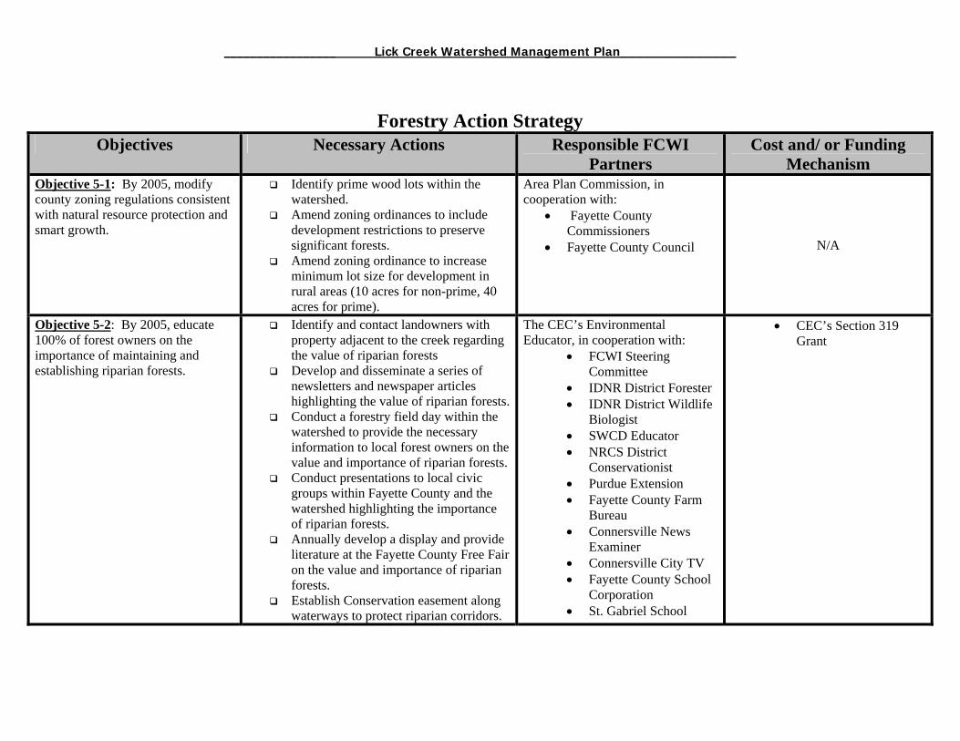
_________________ Lick Creek Watershed Management Plan_______________
Forestry Action Strategy Objectives Necessary Actions Responsible FCWI
Partners Cost and/ or Funding
Mechanism Objective 5-1: By 2005, modify county zoning regulations consistent with natural resource protection and smart growth.
Identify prime wood lots within the watershed.
Amend zoning ordinances to include development restrictions to preserve significant forests.
Amend zoning ordinance to increase minimum lot size for development in rural areas (10 acres for non-prime, 40 acres for prime).
Area Plan Commission, in cooperation with:
• Fayette County Commissioners
• Fayette County Council
N/A
Objective 5-2: By 2005, educate 100% of forest owners on the importance of maintaining and establishing riparian forests.
Identify and contact landowners with property adjacent to the creek regarding the value of riparian forests
Develop and disseminate a series of newsletters and newspaper articles highlighting the value of riparian forests.
Conduct a forestry field day within the watershed to provide the necessary information to local forest owners on the value and importance of riparian forests.
Conduct presentations to local civic groups within Fayette County and the watershed highlighting the importance of riparian forests.
Annually develop a display and provide literature at the Fayette County Free Fair on the value and importance of riparian forests.
Establish Conservation easement along waterways to protect riparian corridors.
The CEC’s Environmental Educator, in cooperation with:
• FCWI Steering Committee
• IDNR District Forester • IDNR District Wildlife
Biologist • SWCD Educator • NRCS District
Conservationist • Purdue Extension • Fayette County Farm
Bureau • Connersville News
Examiner • Connersville City TV • Fayette County School
Corporation • St. Gabriel School
• CEC’s Section 319 Grant
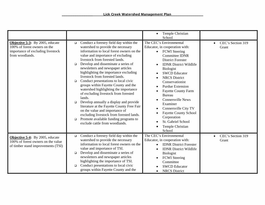
_________________ Lick Creek Watershed Management Plan_______________
• Temple Christian School
Objective 5-3: By 2005, educate 100% of forest owners on the importance of excluding livestock from woodlands.
Conduct a forestry field day within the watershed to provide the necessary information to local forest owners on the value and importance of excluding livestock from forested lands.
Develop and disseminate a series of newsletters and newspaper articles highlighting the importance excluding livestock from forested lands.
Conduct presentations to local civic groups within Fayette County and the watershed highlighting the importance of excluding livestock from forested lands.
Develop annually a display and provide literature at the Fayette County Free Fair on the value and importance of excluding livestock from forested lands.
Promote available funding programs to exclude cattle from woodlands.
The CEC’s Environmental Educator, in cooperation with:
• FCWI Steering Committee IDNR District Forester
• IDNR District Wildlife Biologist
• SWCD Educator • NRCS District
Conservationist • Purdue Extension • Fayette County Farm
Bureau • Connersville News
Examiner • Connersville City TV • Fayette County School
Corporation • St. Gabriel School • Temple Christian
School
• CEC’s Section 319 Grant
Objective 5-4: By 2005, educate 100% of forest owners on the value of timber stand improvements (TSI)
Conduct a forestry field day within the watershed to provide the necessary information to local forest owners on the value and importance of TSI.
Develop and disseminate a series of newsletters and newspaper articles highlighting the importance of TSI.
Conduct presentations to local civic groups within Fayette County and the
The CEC’s Environmental Educator, in cooperation with:
• IDNR District Forester • IDNR District Wildlife
Biologist • FCWI Steering
Committee • SWCD Educator • NRCS District
• CEC’s Section 319 Grant
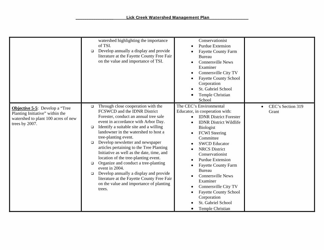
_________________ Lick Creek Watershed Management Plan_______________
watershed highlighting the importance of TSI.
Develop annually a display and provide literature at the Fayette County Free Fair on the value and importance of TSI.
Conservationist • Purdue Extension • Fayette County Farm
Bureau • Connersville News
Examiner • Connersville City TV • Fayette County School
Corporation • St. Gabriel School • Temple Christian
School Objective 5-5: Develop a “Tree Planting Initiative” within the watershed to plant 100 acres of new trees by 2007.
Through close cooperation with the FCSWCD and the IDNR District Forester, conduct an annual tree sale event in accordance with Arbor Day.
Identify a suitable site and a willing landowner in the watershed to host a tree-planting event.
Develop newsletter and newspaper articles pertaining to the Tree Planting Initiative as well as the date, time, and location of the tree-planting event.
Organize and conduct a tree-planting event in 2004.
Develop annually a display and provide literature at the Fayette County Free Fair on the value and importance of planting trees.
The CEC’s Environmental Educator, in cooperation with:
• IDNR District Forester • IDNR District Wildlife
Biologist • FCWI Steering
Committee • SWCD Educator • NRCS District
Conservationist • Purdue Extension • Fayette County Farm
Bureau • Connersville News
Examiner • Connersville City TV • Fayette County School
Corporation • St. Gabriel School • Temple Christian
• CEC’s Section 319 Grant
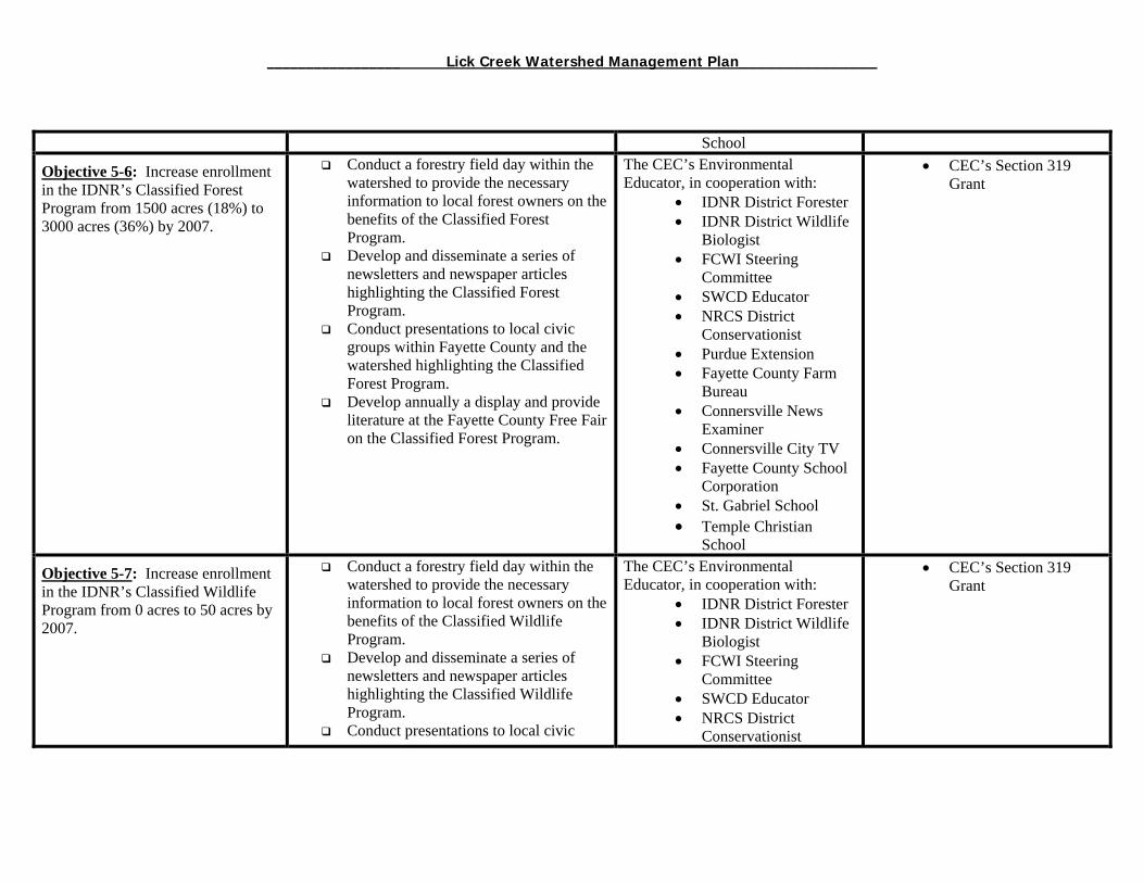
_________________ Lick Creek Watershed Management Plan_______________
School Objective 5-6: Increase enrollment in the IDNR’s Classified Forest Program from 1500 acres (18%) to 3000 acres (36%) by 2007.
Conduct a forestry field day within the watershed to provide the necessary information to local forest owners on the benefits of the Classified Forest Program.
Develop and disseminate a series of newsletters and newspaper articles highlighting the Classified Forest Program.
Conduct presentations to local civic groups within Fayette County and the watershed highlighting the Classified Forest Program.
Develop annually a display and provide literature at the Fayette County Free Fair on the Classified Forest Program.
The CEC’s Environmental Educator, in cooperation with:
• IDNR District Forester • IDNR District Wildlife
Biologist • FCWI Steering
Committee • SWCD Educator • NRCS District
Conservationist • Purdue Extension • Fayette County Farm
Bureau • Connersville News
Examiner • Connersville City TV • Fayette County School
Corporation • St. Gabriel School • Temple Christian
School
• CEC’s Section 319 Grant
Objective 5-7: Increase enrollment in the IDNR’s Classified Wildlife Program from 0 acres to 50 acres by 2007.
Conduct a forestry field day within the watershed to provide the necessary information to local forest owners on the benefits of the Classified Wildlife Program.
Develop and disseminate a series of newsletters and newspaper articles highlighting the Classified Wildlife Program.
Conduct presentations to local civic
The CEC’s Environmental Educator, in cooperation with:
• IDNR District Forester • IDNR District Wildlife
Biologist • FCWI Steering
Committee • SWCD Educator • NRCS District
Conservationist
• CEC’s Section 319 Grant

_________________ Lick Creek Watershed Management Plan_______________
groups within Fayette County and the watershed highlighting the Classified Wildlife Program.
Develop annually a display and provide literature at the Fayette County Free Fair on the Classified Wildlife Program.
• Purdue Extension • Fayette County Farm
Bureau • Connersville News
Examiner • Connersville City TV • Fayette County School
Corporation • St. Gabriel School • Temple Christian
School Objective 5-8: By 2005, educate 100% of forest owners on the economic and environmental benefits of utilizing best management practices during logging activities.
Conduct a forestry field day within the watershed to provide the necessary information to local forest owners on and logging professionals on the benefits of utilizing BMPs while harvesting timber.
Conduct a training course for logging professionals on the utilization of BMPs.
Develop and disseminate a series of newsletters and newspaper articles highlighting the importance of utilizing BMPs while harvesting timber.
Conduct presentations to local civic groups within Fayette County and the watershed highlighting the importance of utilizing BMPs while harvesting timber.
Develop annually a display and provide literature at the Fayette County Free Fair on the value and importance of utilizing BMPs while harvesting timber.
The CEC’s Environmental Educator, in cooperation with:
• IDNR District Forester • IDNR District Wildlife
Biologist • FCWI Steering
Committee • SWCD Educator • NRCS District
Conservationist • Purdue Extension • Fayette County Farm
Bureau • Connersville News
Examiner • Connersville City TV • Fayette County School
Corporation • St. Gabriel School • Temple Christian
School
• CEC’s Section 319 Grant

_________________ Lick Creek Watershed Management Plan_______________
Agricultural Management Action Strategy Objective Actions/Strategies Responsible
Partners Cost and/or Funding
Mechanism Objective 6-1: By 2007, minimize E. coli levels resulting from livestock facilities in an attempt to meet state water quality standards.
• Apply for Section 319 funding in October 2004 to hire a SWCD technician to provide technical services to farmers and landowners.
• Apply for IDNR Lake and River Enhancement (LARE) funding to provide cost-share for livestock and manure management.
• Heavily market all cost-share programs available to implement livestock and manure management projects such as the Environmental Quality Inceptive Program (EQIP), Lake and River Enhancement (LARE), etc.
• Annually conduct a series of field days and workshops in the Lick Creek watershed and other areas within Fayette County focusing on livestock and manure management as well as other best management practices.
• Develop and disseminate newsletters to farmers within the watershed regarding livestock and manure management.
• Promote annually livestock and manure management at the County Free Fair and other local events.
• Develop an FCSWCD website as a means of providing agricultural conservation information to farmers
Fayette County SWCD and NRCS staff in cooperation with:
• FCWI Steering Committee • Purdue Extension • Fayette County Farm
Bureau • CEC Environmental
Educator • Connersville News
Examiner • Connersville City TV • Fayette County School
Corporation • Future Farmers of America
(FFA) • 4-H
• Section 319 Grant or County appropriations for SWCD technician ($40K/year)
• LARE cost-share dollars, (minimum $30K/year)
• SWCD general operating funds to market all available cost-share programs via newsletters, field days, and web site ($5K/year)
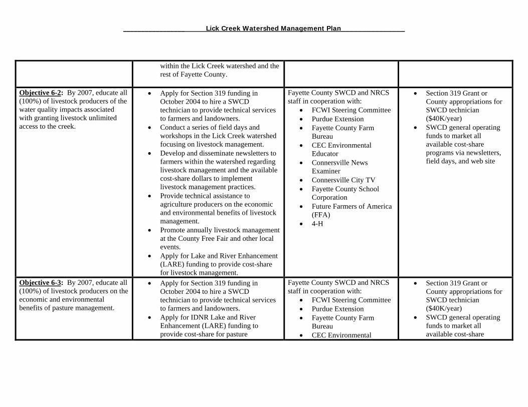
_________________ Lick Creek Watershed Management Plan_______________
within the Lick Creek watershed and the rest of Fayette County.
Objective 6-2: By 2007, educate all (100%) of livestock producers of the water quality impacts associated with granting livestock unlimited access to the creek.
• Apply for Section 319 funding in October 2004 to hire a SWCD technician to provide technical services to farmers and landowners.
• Conduct a series of field days and workshops in the Lick Creek watershed focusing on livestock management.
• Develop and disseminate newsletters to farmers within the watershed regarding livestock management and the available cost-share dollars to implement livestock management practices.
• Provide technical assistance to agriculture producers on the economic and environmental benefits of livestock management.
• Promote annually livestock management at the County Free Fair and other local events.
• Apply for Lake and River Enhancement (LARE) funding to provide cost-share for livestock management.
Fayette County SWCD and NRCS staff in cooperation with:
• FCWI Steering Committee • Purdue Extension • Fayette County Farm
Bureau • CEC Environmental
Educator • Connersville News
Examiner • Connersville City TV • Fayette County School
Corporation • Future Farmers of America
(FFA) • 4-H
• Section 319 Grant or County appropriations for SWCD technician ($40K/year)
• SWCD general operating funds to market all available cost-share programs via newsletters, field days, and web site
Objective 6-3: By 2007, educate all (100%) of livestock producers on the economic and environmental benefits of pasture management.
• Apply for Section 319 funding in October 2004 to hire a SWCD technician to provide technical services to farmers and landowners.
• Apply for IDNR Lake and River Enhancement (LARE) funding to provide cost-share for pasture
Fayette County SWCD and NRCS staff in cooperation with:
• FCWI Steering Committee • Purdue Extension • Fayette County Farm
Bureau • CEC Environmental
• Section 319 Grant or County appropriations for SWCD technician ($40K/year)
• SWCD general operating funds to market all available cost-share
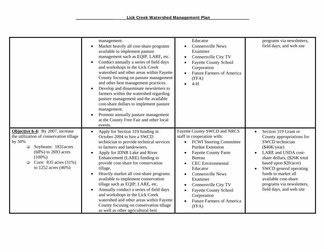
_________________ Lick Creek Watershed Management Plan_______________
management. • Market heavily all cost-share programs
available to implement pasture management such as EQIP, LARE, etc.
• Conduct annually a series of field days and workshops in the Lick Creek watershed and other areas within Fayette County focusing on pasture management and other best management practices.
• Develop and disseminate newsletters to farmers within the watershed regarding pasture management and the available cost-share dollars to implement pasture management.
• Promote annually pasture management at the County Free Fair and other local events.
Educator • Connersville News
Examiner • Connersville City TV • Fayette County School
Corporation • Future Farmers of America
(FFA) • 4-H
programs via newsletters, field days, and web site
Objective 6-4: By 2007, increase the utilization of conservation tillage by 50%
Soybeans: 1831acres (68%) to 2693 acres (100%)
Corn: 835 acres (31%) to 1252 acres (46%)
• Apply for Section 319 funding in October 2004 to hire a SWCD technician to provide technical services to farmers and landowners.
• Apply for IDNR Lake and River Enhancement (LARE) funding to provide cost-share for conservation tillage.
• Heavily market all cost-share programs available to implement conservation tillage such as EQIP, LARE, etc.
• Annually conduct a series of field days and workshops in the Lick Creek watershed and other areas within Fayette County focusing on conservation tillage as well as other agricultural best
Fayette County SWCD and NRCS staff in cooperation with:
• FCWI Steering Committee Purdue Extension
• Fayette County Farm Bureau
• CEC Environmental Educator
• Connersville News Examiner
• Connersville City TV • Fayette County School
Corporation • Future Farmers of America
(FFA)
• Section 319 Grant or County appropriations for SWCD technician ($40K/year)
• LARE and USDA cost-share dollars, ($26K total based upon $20/acre)
• SWCD general operating funds to market all available cost-share programs via newsletters, field days, and web site
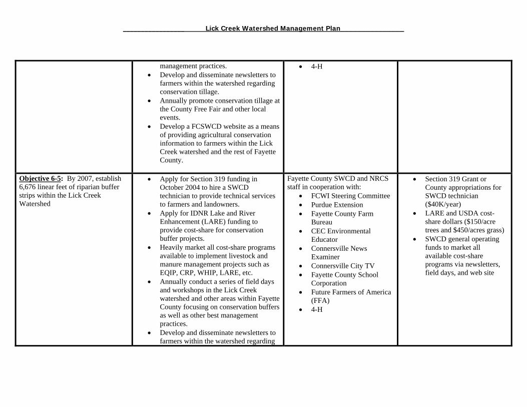
_________________ Lick Creek Watershed Management Plan_______________
management practices. • Develop and disseminate newsletters to
farmers within the watershed regarding conservation tillage.
• Annually promote conservation tillage at the County Free Fair and other local events.
• Develop a FCSWCD website as a means of providing agricultural conservation information to farmers within the Lick Creek watershed and the rest of Fayette County.
• 4-H
Objective 6-5: By 2007, establish 6,676 linear feet of riparian buffer strips within the Lick Creek Watershed
• Apply for Section 319 funding in October 2004 to hire a SWCD technician to provide technical services to farmers and landowners.
• Apply for IDNR Lake and River Enhancement (LARE) funding to provide cost-share for conservation buffer projects.
• Heavily market all cost-share programs available to implement livestock and manure management projects such as EQIP, CRP, WHIP, LARE, etc.
• Annually conduct a series of field days and workshops in the Lick Creek watershed and other areas within Fayette County focusing on conservation buffers as well as other best management practices.
• Develop and disseminate newsletters to farmers within the watershed regarding
Fayette County SWCD and NRCS staff in cooperation with:
• FCWI Steering Committee • Purdue Extension • Fayette County Farm
Bureau • CEC Environmental
Educator • Connersville News
Examiner • Connersville City TV • Fayette County School
Corporation • Future Farmers of America
(FFA) • 4-H
• Section 319 Grant or County appropriations for SWCD technician ($40K/year)
• LARE and USDA cost-share dollars ($150/acre trees and $450/acres grass)
• SWCD general operating funds to market all available cost-share programs via newsletters, field days, and web site
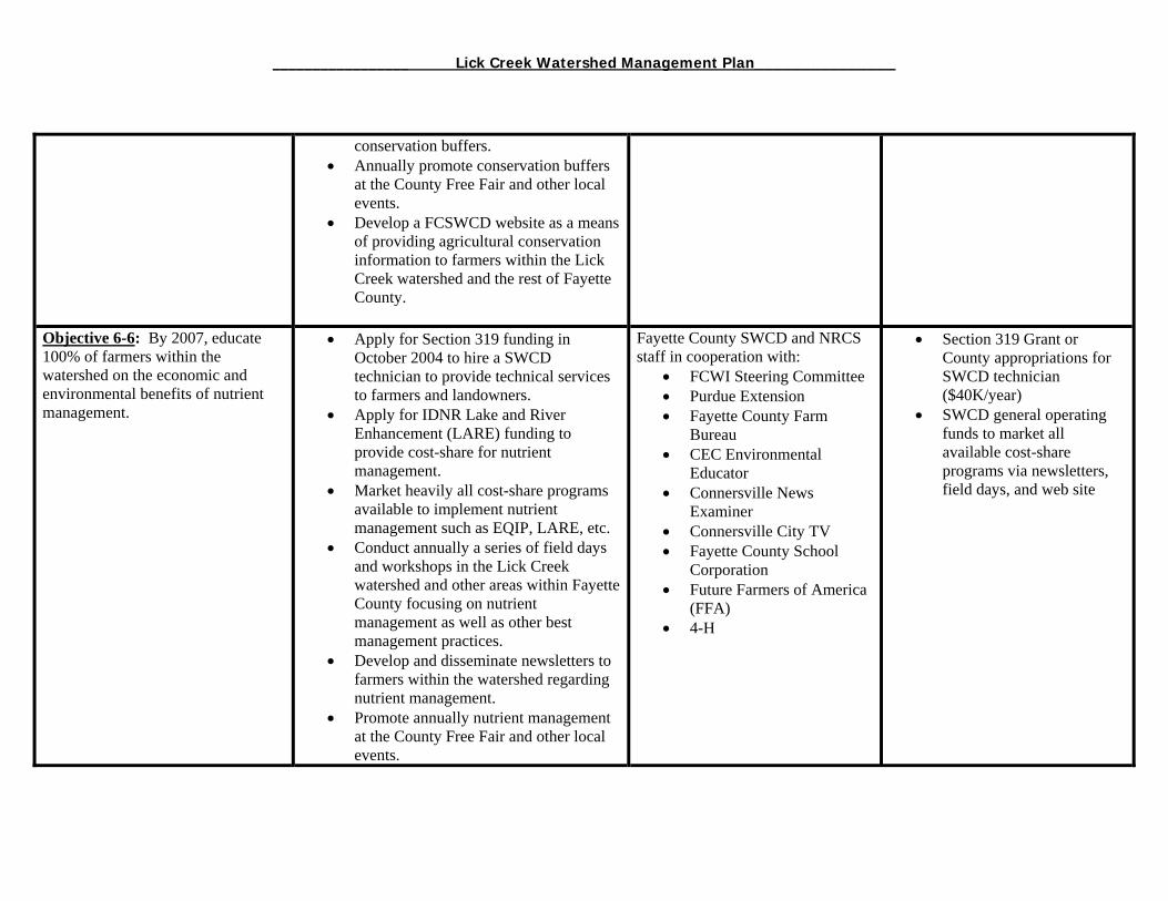
_________________ Lick Creek Watershed Management Plan_______________
conservation buffers. • Annually promote conservation buffers
at the County Free Fair and other local events.
• Develop a FCSWCD website as a means of providing agricultural conservation information to farmers within the Lick Creek watershed and the rest of Fayette County.
Objective 6-6: By 2007, educate 100% of farmers within the watershed on the economic and environmental benefits of nutrient management.
• Apply for Section 319 funding in October 2004 to hire a SWCD technician to provide technical services to farmers and landowners.
• Apply for IDNR Lake and River Enhancement (LARE) funding to provide cost-share for nutrient management.
• Market heavily all cost-share programs available to implement nutrient management such as EQIP, LARE, etc.
• Conduct annually a series of field days and workshops in the Lick Creek watershed and other areas within Fayette County focusing on nutrient management as well as other best management practices.
• Develop and disseminate newsletters to farmers within the watershed regarding nutrient management.
• Promote annually nutrient management at the County Free Fair and other local events.
Fayette County SWCD and NRCS staff in cooperation with:
• FCWI Steering Committee • Purdue Extension • Fayette County Farm
Bureau • CEC Environmental
Educator • Connersville News
Examiner • Connersville City TV • Fayette County School
Corporation • Future Farmers of America
(FFA) • 4-H
• Section 319 Grant or County appropriations for SWCD technician ($40K/year)
• SWCD general operating funds to market all available cost-share programs via newsletters, field days, and web site

_________________ Lick Creek Watershed Management Plan_______________
• Develop an FCSWCD website as a means of providing agricultural conservation information to farmers within the Lick Creek watershed and the rest of Fayette County.
Objective 6-7: By 2007, educate 100% of farmers within the watershed on the economic and environmental benefits of pest management.
• Apply for Section 319 funding in October 2004 to hire a SWCD technician to provide technical services to farmers and landowners.
• Apply for IDNR Lake and River Enhancement (LARE) funding to provide cost-share for pest management.
• Heavily market all cost-share programs available to implement pest management projects such as EQIP, LARE, etc.
• Annually conduct a series of field days and workshops in the Lick Creek watershed and other areas within Fayette County focusing on pest management as well as other best management practices.
• Develop and disseminate newsletters to farmers within the watershed regarding pest management.
• Annually promote pest management at the County Free Fair and other local events.
• Develop a FCSWCD website as a means of providing agricultural conservation information to farmers within the Lick Creek watershed and the rest of Fayette County.
Fayette County SWCD and NRCS staff in cooperation with:
• FCWI Steering Committee • Purdue Extension • Fayette County Farm
Bureau • CEC Environmental
Educator • Connersville News
Examiner • Connersville City TV • Fayette County School
Corporation • Future Farmers of America
(FFA) • 4-H
• Section 319 Grant or County appropriations for SWCD technician ($40K/year)
• SWCD general operating funds to market all available cost-share programs via newsletters, field days, and web site
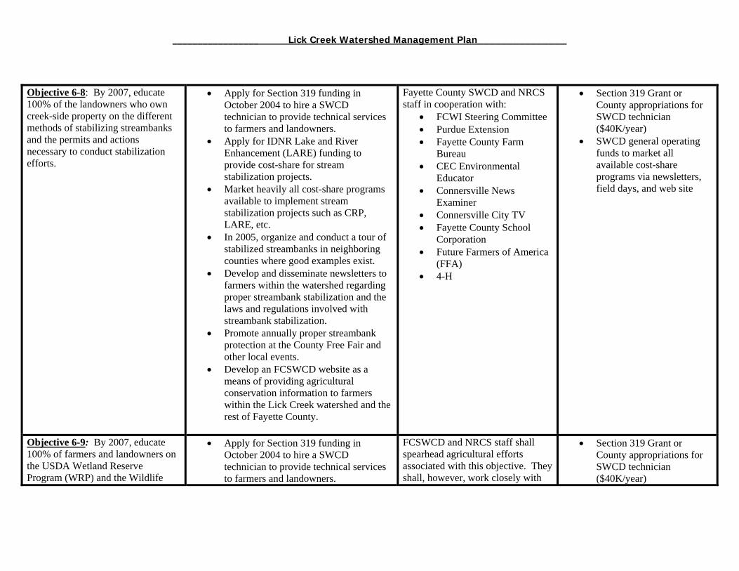
_________________ Lick Creek Watershed Management Plan_______________
Objective 6-8: By 2007, educate 100% of the landowners who own creek-side property on the different methods of stabilizing streambanks and the permits and actions necessary to conduct stabilization efforts.
• Apply for Section 319 funding in October 2004 to hire a SWCD technician to provide technical services to farmers and landowners.
• Apply for IDNR Lake and River Enhancement (LARE) funding to provide cost-share for stream stabilization projects.
• Market heavily all cost-share programs available to implement stream stabilization projects such as CRP, LARE, etc.
• In 2005, organize and conduct a tour of stabilized streambanks in neighboring counties where good examples exist.
• Develop and disseminate newsletters to farmers within the watershed regarding proper streambank stabilization and the laws and regulations involved with streambank stabilization.
• Promote annually proper streambank protection at the County Free Fair and other local events.
• Develop an FCSWCD website as a means of providing agricultural conservation information to farmers within the Lick Creek watershed and the rest of Fayette County.
Fayette County SWCD and NRCS staff in cooperation with:
• FCWI Steering Committee • Purdue Extension • Fayette County Farm
Bureau • CEC Environmental
Educator • Connersville News
Examiner • Connersville City TV • Fayette County School
Corporation • Future Farmers of America
(FFA) • 4-H
• Section 319 Grant or County appropriations for SWCD technician ($40K/year)
• SWCD general operating funds to market all available cost-share programs via newsletters, field days, and web site
Objective 6-9: By 2007, educate 100% of farmers and landowners on the USDA Wetland Reserve Program (WRP) and the Wildlife
• Apply for Section 319 funding in October 2004 to hire a SWCD technician to provide technical services to farmers and landowners.
FCSWCD and NRCS staff shall spearhead agricultural efforts associated with this objective. They shall, however, work closely with
• Section 319 Grant or County appropriations for SWCD technician ($40K/year)
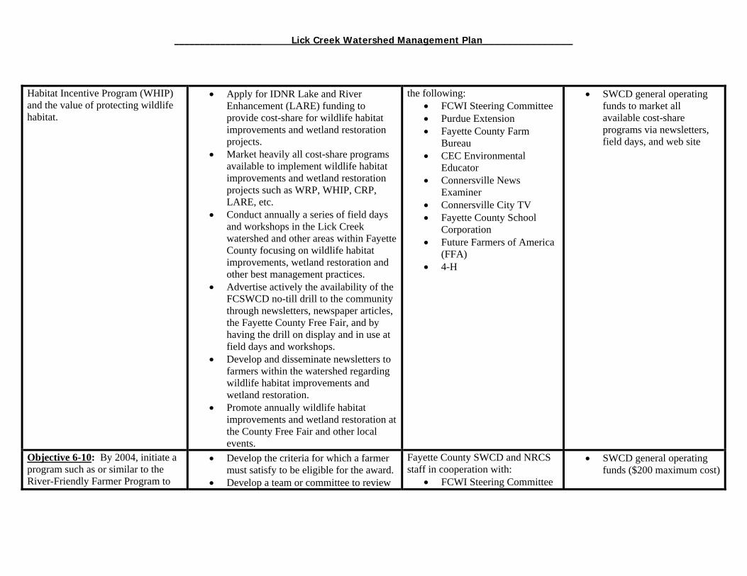
_________________ Lick Creek Watershed Management Plan_______________
Habitat Incentive Program (WHIP) and the value of protecting wildlife habitat.
• Apply for IDNR Lake and River Enhancement (LARE) funding to provide cost-share for wildlife habitat improvements and wetland restoration projects.
• Market heavily all cost-share programs available to implement wildlife habitat improvements and wetland restoration projects such as WRP, WHIP, CRP, LARE, etc.
• Conduct annually a series of field days and workshops in the Lick Creek watershed and other areas within Fayette County focusing on wildlife habitat improvements, wetland restoration and other best management practices.
• Advertise actively the availability of the FCSWCD no-till drill to the community through newsletters, newspaper articles, the Fayette County Free Fair, and by having the drill on display and in use at field days and workshops.
• Develop and disseminate newsletters to farmers within the watershed regarding wildlife habitat improvements and wetland restoration.
• Promote annually wildlife habitat improvements and wetland restoration at the County Free Fair and other local events.
the following: • FCWI Steering Committee • Purdue Extension • Fayette County Farm
Bureau • CEC Environmental
Educator • Connersville News
Examiner • Connersville City TV • Fayette County School
Corporation • Future Farmers of America
(FFA) • 4-H
• SWCD general operating funds to market all available cost-share programs via newsletters, field days, and web site
Objective 6-10: By 2004, initiate a program such as or similar to the River-Friendly Farmer Program to
• Develop the criteria for which a farmer must satisfy to be eligible for the award.
• Develop a team or committee to review
Fayette County SWCD and NRCS staff in cooperation with:
• FCWI Steering Committee
• SWCD general operating funds ($200 maximum cost)

_________________ Lick Creek Watershed Management Plan_______________
recognize a local farmer for his or her conservation practices.
nominations for this award. • Advertise the program through Fayette
County Farm Bureau, the Connersville News Examiner, FCSWCD Newsletters and other local means.
• Purchase and present the award at the Annual FCSWCD Meetings.
• Purdue Extension • Fayette County Farm
Bureau • CEC Environmental
Educator • Connersville News
Examiner • Connersville City TV • Fayette County School
Corporation • Future Farmers of America
(FFA) • 4-H
Objective 6-11: Educate all (100%) of livestock producers of the water quality/forest impacts related to granting livestock access to forestland.
• Apply for Section 319 funding in October 2004 to hire a SWCD technician to provide technical services to farmers and landowners.
• Apply for IDNR Lake and River Enhancement (LARE) funding to provide cost-share for livestock management.
• Market heavily all cost-share programs available to implement livestock management practices such as EQIP, LARE, etc.
• Conduct annually a series of field days and workshops in the Lick Creek watershed and other areas within Fayette County focusing on livestock management and other best management practices.
• Develop and disseminate newsletters to
Fayette County SWCD and NRCS staff in cooperation with:
• FCWI Steering Committee • Purdue Extension • Fayette County Farm
Bureau • IDNR District Forester • CEC Environmental
Educator • Connersville News
Examiner • Connersville City TV • Fayette County School
Corporation • Future Farmers of America
(FFA) • 4-H (FFA) • 4-H
• Section 319 Grant or County appropriations for SWCD technician ($40K/year)
• SWCD general operating funds to market all available cost-share programs via newsletters, field days, and web site
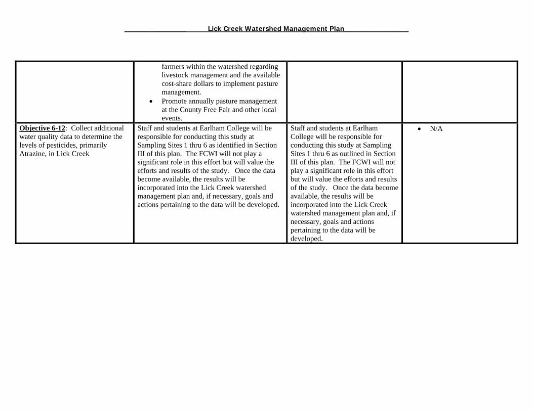
_________________ Lick Creek Watershed Management Plan_______________
farmers within the watershed regarding livestock management and the available cost-share dollars to implement pasture management.
• Promote annually pasture management at the County Free Fair and other local events.
Objective 6-12: Collect additional water quality data to determine the levels of pesticides, primarily Atrazine, in Lick Creek
Staff and students at Earlham College will be responsible for conducting this study at Sampling Sites 1 thru 6 as identified in Section III of this plan. The FCWI will not play a significant role in this effort but will value the efforts and results of the study. Once the data become available, the results will be incorporated into the Lick Creek watershed management plan and, if necessary, goals and actions pertaining to the data will be developed.
Staff and students at Earlham College will be responsible for conducting this study at Sampling Sites 1 thru 6 as outlined in Section III of this plan. The FCWI will not play a significant role in this effort but will value the efforts and results of the study. Once the data become available, the results will be incorporated into the Lick Creek watershed management plan and, if necessary, goals and actions pertaining to the data will be developed.
• N/A
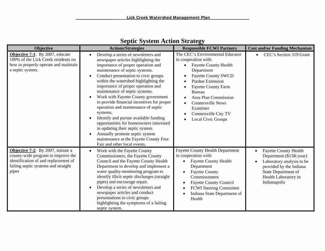
_________________ Lick Creek Watershed Management Plan_______________
Septic System Action Strategy Objective Actions/Strategies Responsible FCWI Partners Cost and/or Funding Mechanism
Objective 7-1: By 2007, educate 100% of the Lick Creek residents on how to properly operate and maintain a septic system.
• Develop a series of newsletters and newspaper articles highlighting the importance of proper operation and maintenance of septic systems.
• Conduct presentation to civic groups within the watershed highlighting the importance of proper operation and maintenance of septic systems.
• Work with Fayette County government to provide financial incentives for proper operation and maintenance of septic systems.
• Identify and pursue available funding opportunities for homeowners interested in updating their septic system.
• Annually promote septic system maintenance at the Fayette County Free Fair and other local events.
The CEC’s Environmental Educator in cooperation with:
• Fayette County Health Department
• Fayette County SWCD • Purdue Extension • Fayette County Farm
Bureau • Area Plan Commission • Connersville News
Examiner • Connersville City TV • Local Civic Groups
• CEC’s Section 319 Grant
Objective 7-2: By 2007, initiate a county-wide program to improve the identification of and replacement of failing septic systems and straight pipes
• Work with the Fayette County Commissioners, the Fayette County Council and the Fayette County Health Department to develop and implement a water quality-monitoring program to identify illicit septic discharges (straight pipes) and encourage repair.
• Develop a series of newsletters and newspaper articles and conduct presentations to civic groups highlighting the symptoms of a failing septic system.
Fayette County Health Department in cooperation with:
• Fayette County Health Department
• Fayette County Commissioners
• Fayette County Council • FCWI Steering Committee • Indiana State Department of
Health
• Fayette County Health Department ($15K/year)
• Laboratory analysis to be provided by the Indiana State Department of Health Laboratory in Indianapolis
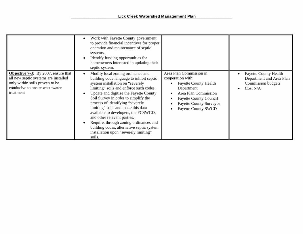
_________________ Lick Creek Watershed Management Plan_______________
• Work with Fayette County government to provide financial incentives for proper operation and maintenance of septic systems.
• Identify funding opportunities for homeowners interested in updating their septic system.
Objective 7-3: By 2007, ensure that all new septic systems are installed only within soils proven to be conducive to onsite wastewater treatment
• Modify local zoning ordinance and building code language to inhibit septic system installation on “severely limiting” soils and enforce such codes.
• Update and digitize the Fayette County Soil Survey in order to simplify the process of identifying “severely limiting” soils and make this data available to developers, the FCSWCD, and other relevant parties.
• Require, through zoning ordinances and building codes, alternative septic system installation upon “severely limiting” soils.
Area Plan Commission in cooperation with:
• Fayette County Health Department
• Area Plan Commission • Fayette County Council • Fayette County Surveyor • Fayette County SWCD
• Fayette County Health Department and Area Plan Commission budgets
• Cost N/A

_________________ Lick Creek Watershed Management Plan_______________
Local Government Action Strategy Objective Actions/Strategies Responsible FCWI Partners Cost and/or Funding Mechanism
Objective 8-1: By 2006, acquire the necessary funding to hire technical SWCD staff including an agricultural specialist and an erosion and sediment control specialist.
Apply for a Section 319 Grant to hire an erosion control specialist or utilize county/city funding.
Fayette County SWCD in cooperation with:
Area Plan Commission County/City Government
2004 Section 319 Grant or County Appropriations ($40K/ year)
Objective 8-2: Provide training for local developers, SWCD Supervisors, and other relevant entities on the utilization of erosion and sediment control practices for development projects.
Conduct a series of field days/workshops on the proper use of erosion and sediment control best management practices.
Fayette County SWCD in cooperation with
IDNR Storm Water Specialist
SWCD Building Inspector County Surveyor FCWI Steering Committee
SWCD Funds or County/City Appropriations ($5K total)
Objective 8-3: Educate developers, politicians, and landowners regarding rural development.
Emphasize SWCD, APC, Drainage Board coordination during plan review process
Strengthen project development review committee
Utilize SWCD technician on project development review committee.
Fayette County SWCD in cooperation with:
Area Plan Commission FCWI Steering Committee
N/A
Objective 8-4: Develop and maintain a water quality/quantity dialogue between relevant county and city staff by 2006.
Develop a county-wide watershed team to discuss water quality and water quantity issues consisting of:
Area Plan Commission staff Soil and Water Conservation District
staff Health Department staff County and City Engineers County Surveyor Drainage Board Members
Area Plan Commission in cooperation with:
Building Inspector Health Department staff County and City Engineers County Surveyor Drainage Board Members City Street Department
staff County Highway staff
N/A

_________________ Lick Creek Watershed Management Plan_______________
City Street Department staff County Highway Department staff Connersville MS4 Operator
Connersville Utilities
Objective 8-5: By 2006, acquire the necessary funding to develop a stream and well monitoring program to proactively identify and address the streams of Fayette County suffering from septic system failure and other sources of pollution
Work with the Fayette County Commissioners, the Fayette County Council and the Fayette County Health Department to develop and implement a water quality-monitoring program to identify illicit septic discharges (straight pipes) and encourage repair.
Develop a series of newsletters and newspaper articles and conduct presentations to civic groups highlighting the symptoms of a failing septic system.
Work with Fayette County government to provide financial incentives for proper operation and maintenance of septic systems.
Identify funding opportunities for homeowners interested in updating their septic system.
Fayette County Health Department in cooperation with:
Fayette County Health Department
Fayette County Commissioners
Fayette County Council FCWI Steering Committee Indiana State Department
of Health
Fayette County Health Department ($15K/year) Laboratory analysis to be provided by the Indiana State Department of Health Laboratory in Indianapolis
Objective 8-6: By 2006, develop an incentive program by which residents are encouraged to maintain, repair and or replace failing or faulty septic systems.
Modify local zoning ordinance and building code language to inhibit septic system installation on “severely limiting” soils and enforce such codes.
Update and digitize the Fayette County Soil Survey in order to simplify the process of identifying “severely limiting” soils and make this data available to developers, the FCSWCD, and other relevant parties.
Area Plan Commission in cooperation with:
Fayette County Health Department
Area Plan Commission Fayette County Council Fayette County Surveyor Fayette County SWCD
Fayette County Health Department and Area Plan Commission budgets Cost N/A
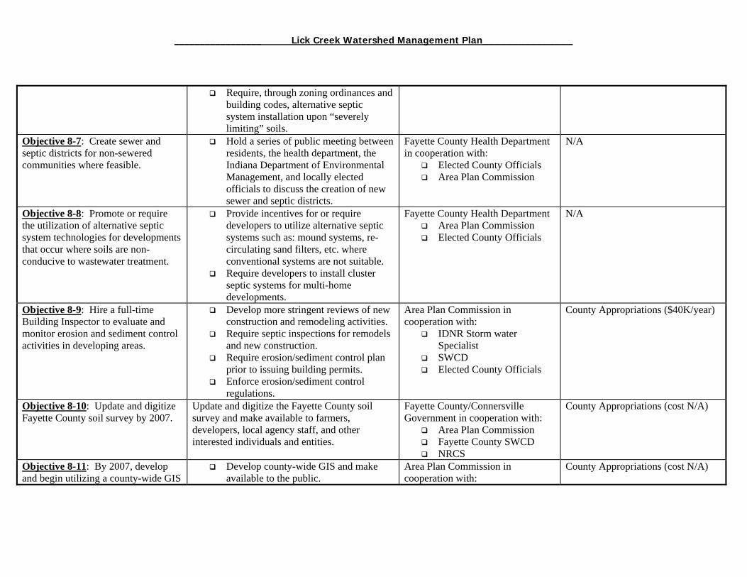
_________________ Lick Creek Watershed Management Plan_______________
Require, through zoning ordinances and building codes, alternative septic system installation upon “severely limiting” soils.
Objective 8-7: Create sewer and septic districts for non-sewered communities where feasible.
Hold a series of public meeting between residents, the health department, the Indiana Department of Environmental Management, and locally elected officials to discuss the creation of new sewer and septic districts.
Fayette County Health Department in cooperation with:
Elected County Officials Area Plan Commission
N/A
Objective 8-8: Promote or require the utilization of alternative septic system technologies for developments that occur where soils are non-conducive to wastewater treatment.
Provide incentives for or require developers to utilize alternative septic systems such as: mound systems, re-circulating sand filters, etc. where conventional systems are not suitable.
Require developers to install cluster septic systems for multi-home developments.
Fayette County Health Department Area Plan Commission Elected County Officials
N/A
Objective 8-9: Hire a full-time Building Inspector to evaluate and monitor erosion and sediment control activities in developing areas.
Develop more stringent reviews of new construction and remodeling activities.
Require septic inspections for remodels and new construction.
Require erosion/sediment control plan prior to issuing building permits.
Enforce erosion/sediment control regulations.
Area Plan Commission in cooperation with:
IDNR Storm water Specialist
SWCD Elected County Officials
County Appropriations ($40K/year)
Objective 8-10: Update and digitize Fayette County soil survey by 2007.
Update and digitize the Fayette County soil survey and make available to farmers, developers, local agency staff, and other interested individuals and entities.
Fayette County/Connersville Government in cooperation with:
Area Plan Commission Fayette County SWCD NRCS
County Appropriations (cost N/A)
Objective 8-11: By 2007, develop and begin utilizing a county-wide GIS
Develop county-wide GIS and make available to the public.
Area Plan Commission in cooperation with:
County Appropriations (cost N/A)

_________________ Lick Creek Watershed Management Plan_______________
system to identify natural areas, sensitive areas, prime agricultural lands (including forested land), non-prime agricultural lands, soils suitable for on-site septic systems, floodplains, etc.
Utilize GIS to identify and protect environmentally sensitive areas.
Fayette County/Connersville Government
SWCD/NRCS County Surveyor
Objective 8-12: Increase acreage requirements for development in agriculture district (A1) from 3 acres to 40 acres and A2 from 1 acre to 10 acres for all of Fayette County.
Utilize digitized soil survey to determine which areas of Fayette County are “prime” agricultural lands.
Recognize forestlands as “prime” agricultural lands when updating the zoning classifications.
Increase the acreage requirements for development:
A1: 3 acres to 40 acres A2: 1 acre to 10 acres
Area Plan Commission in cooperation with:
City/County Elected Officials
SWCD/NRCS IDNR, District Forester
County Appropriations (cost N/A)
Objective 8-13: Implement planning tools to ensure protection and enhancement of natural resources and water quality.
Develop ordinance which requires new developments to satisfy the following criteria:
stream setbacks floodplain protection/management wetland/tree conservation requirements impervious surface minimization open space preservation conservation design septic density requirements water supply availability
Area Plan Commission in cooperation with:
City/County Elected Officials
Health Department Soil and Water
Conservation District IDNR District Forester Parks Department Staff
County Appropriations (cost N/A)
Objective 8-14: By 2004, increase communication and collaboration between the Fayette County Surveyor, the FCSWCD and the NRCS to identify and address stream and ditch segments contributing to water quality
Organize and conduct a meeting with relevant parties to discuss the feasibility of this objective.
County Drainage Board in cooperation with:
County Surveyor County Highway
Department County Commissioners
County Appropriations (cost N/A)
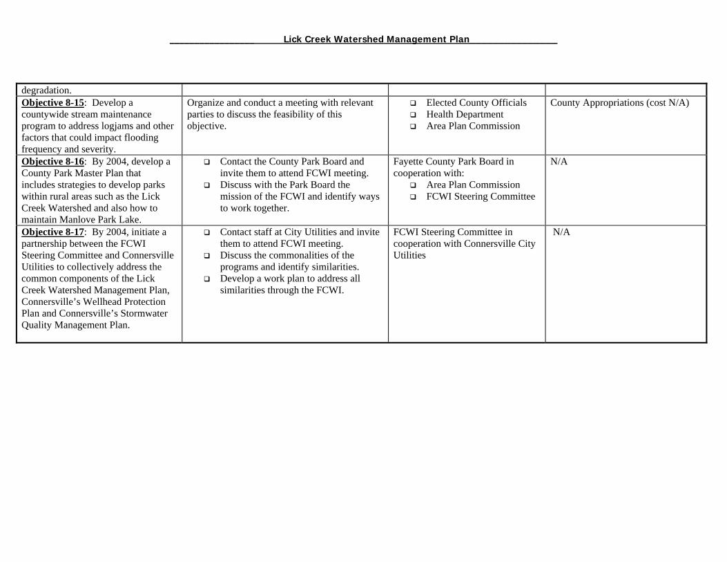
_________________ Lick Creek Watershed Management Plan_______________
degradation. Objective 8-15: Develop a countywide stream maintenance program to address logjams and other factors that could impact flooding frequency and severity.
Organize and conduct a meeting with relevant parties to discuss the feasibility of this objective.
Elected County Officials Health Department Area Plan Commission
County Appropriations (cost N/A)
Objective 8-16: By 2004, develop a County Park Master Plan that includes strategies to develop parks within rural areas such as the Lick Creek Watershed and also how to maintain Manlove Park Lake.
Contact the County Park Board and invite them to attend FCWI meeting.
Discuss with the Park Board the mission of the FCWI and identify ways to work together.
Fayette County Park Board in cooperation with:
Area Plan Commission FCWI Steering Committee
N/A
Objective 8-17: By 2004, initiate a partnership between the FCWI Steering Committee and Connersville Utilities to collectively address the common components of the Lick Creek Watershed Management Plan, Connersville’s Wellhead Protection Plan and Connersville’s Stormwater Quality Management Plan.
Contact staff at City Utilities and invite them to attend FCWI meeting.
Discuss the commonalities of the programs and identify similarities.
Develop a work plan to address all similarities through the FCWI.
FCWI Steering Committee in cooperation with Connersville City Utilities
N/A


_________________ Lick Creek Watershed Management Plan_______________
Literature Cited ConservationTillage Information Center. (2003). Core 4 Conservation. http://www.ctic.purdue.edu/core4/Core4Main.html Dalbom, Clint. (2001, March). Watch those Hoofs. Missouri Conservationist Online. http://www.conservation.state.mo.us/conmag/2001/03/40.htm Fayette County Chamber Of Commerce. (1996). History of Connersville, Indiana. http://www.connersvillein.com/econdev/history.html Hartman, Lyn and Mandy Burk. Volunteer Stream Monitoring Training Manual. 2nd edition, November 2000. Indiana Dept. of Natural Resources-Division of Soil Conservation and Purdue University Dept. of Agronomy Indiana Department of Natural Resources. (2003). Classified Wildlife Habitat Program. http://www.in.gov/dnr/fishwild/hunt/classified.pdf Indiana Department of Natural Resources Hoosier Riverwatch Program. (2000). Volunteer Stream Monitoring Manual Kentucky Division of Fish & Wildlife Resources. (2003). Timber Stand Improvement. http://www.kdfwr.state.ky.us/timber.htm National Wildlife Federation. (2003). Wetlands at Risk. http: http://www.nwf.org/backyardwildlifehabitat/newsletter/wetlandsrisksummer2002.cfm Natural Resource Commission. (1997, October). Outstanding Rivers List For Indiana. http://www.in.gov/nrc/policy/outstand.html Septic Seep. (2003). How Septic Systems Work. http://www.septicseep.com/septicsystem.htm Crowder and Associates, Inc. (1967). Soil and Water Survey. Standard Methods for the Examination of Water and Wastewater, 19th Ed., APHA-AWWA-WEF; Washington D.C., 1993, Method 9223B Storm Water Management Resource Center. (2003). Pollution Prevention Fact Sheet: Septic System Controls. http://www.stormwatercenter.net/Pollution_Prevention_Factsheets/ United States Department of Agriculture. (2003). Indiana Agricultural Statistics Service. http://www.nass.usda.gov/in/. United States Environmental Protection Agency. (2003, February). Protecting Water Quality From Agricultural Runoff. http://www.epa.gov/water/yearofcleanwater/docs/NPS_Ag-facts_final.pdf United States Geological Survey. (2003, April). Hydrologic Unit Maps. http://water.usgs.gov/GIS/huc.html. WRAS Development Site. (2003). Causes and Sources of Water Pollution. http://www.wittmanhydro.com/WRAS/Template/Part1_Chapter3
151
_________________ Lick Creek Watershed Management Plan_______________
Washington State Department of Ecology. (1999, January). Water Quality Guide: Animal Waste Management http://www.ecy.wa.gov/programs/wq/wqguide/animals.html WaterShedds. (2003). Septic Systems. http://h2osparc.wq.ncsu.edu/wetland/aqlife/septic.html
152
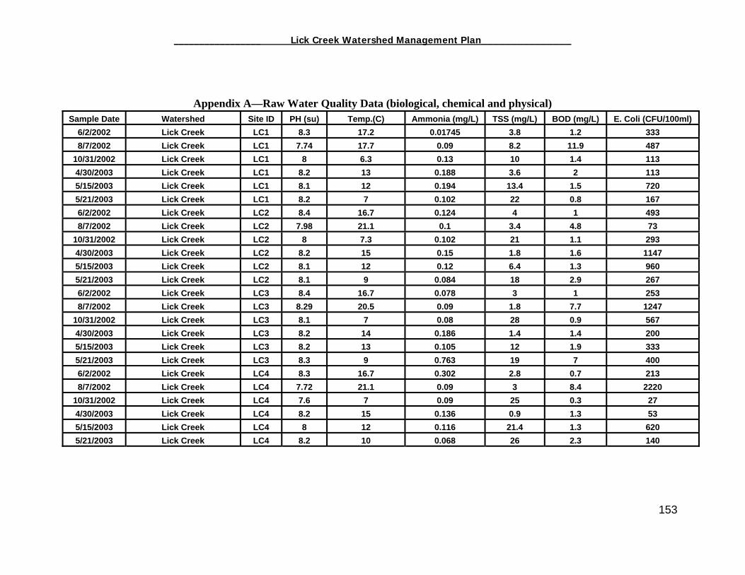
_________________ Lick Creek Watershed Management Plan_______________
Appendix A—Raw Water Quality Data (biological, chemical and physical)
Sample Date Watershed Site ID PH (su) Temp.(C) Ammonia (mg/L) TSS (mg/L) BOD (mg/L) E. Coli (CFU/100ml) 6/2/2002 Lick Creek LC1 8.3 17.2 0.01745 3.8 1.2 3338/7/2002 Lick Creek LC1 7.74 17.7 0.09 8.2 11.9 487
10/31/2002 Lick Creek LC1 8 6.3 0.13 10 1.4 1134/30/2003 Lick Creek LC1 8.2 13 0.188 3.6 2 1135/15/2003 Lick Creek LC1 8.1 12 0.194 13.4 1.5 7205/21/2003 Lick Creek LC1 8.2 7 0.102 22 0.8 1676/2/2002 Lick Creek LC2 8.4 16.7 0.124 4 1 4938/7/2002 Lick Creek LC2 7.98 21.1 0.1 3.4 4.8 73
10/31/2002 Lick Creek LC2 8 7.3 0.102 21 1.1 2934/30/2003 Lick Creek LC2 8.2 15 0.15 1.8 1.6 11475/15/2003 Lick Creek LC2 8.1 12 0.12 6.4 1.3 9605/21/2003 Lick Creek LC2 8.1 9 0.084 18 2.9 2676/2/2002 Lick Creek LC3 8.4 16.7 0.078 3 1 2538/7/2002 Lick Creek LC3 8.29 20.5 0.09 1.8 7.7 1247
10/31/2002 Lick Creek LC3 8.1 7 0.08 28 0.9 5674/30/2003 Lick Creek LC3 8.2 14 0.186 1.4 1.4 2005/15/2003 Lick Creek LC3 8.2 13 0.105 12 1.9 3335/21/2003 Lick Creek LC3 8.3 9 0.763 19 7 4006/2/2002 Lick Creek LC4 8.3 16.7 0.302 2.8 0.7 2138/7/2002 Lick Creek LC4 7.72 21.1 0.09 3 8.4 2220
10/31/2002 Lick Creek LC4 7.6 7 0.09 25 0.3 274/30/2003 Lick Creek LC4 8.2 15 0.136 0.9 1.3 535/15/2003 Lick Creek LC4 8 12 0.116 21.4 1.3 6205/21/2003 Lick Creek LC4 8.2 10 0.068 26 2.3 140
153

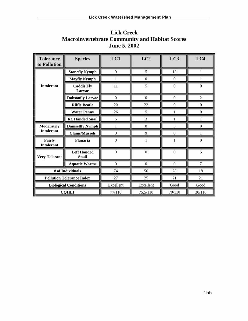
_________________ Lick Creek Watershed Management Plan_______________
Lick Creek Macroinvertebrate Community and Habitat Scores
June 5, 2002
Tolerance to Pollution
Species LC1 LC2 LC3 LC4
Stonefly Nymph 9 5 13 1
Mayfly Nymph 1 0 0 1
Caddis Fly Larvae
11 5 0 0
Dobsonfly Larvae 0 0 0 2
Riffle Beatle 20 22 9 0
Water Penny 26 5 1 0
Intolerant
Rt. Handed Snail 6 3 1 1
Damselfly Nymph 1 0 3 0 Moderately Intolerant Clams/Mussels 0 9 0 1
Fairly Intolerant
Planaria 0 1 1 0
Left Handed Snail
0 0 0 5 Very Tolerant
Aquatic Worms 0 0 0 7
# of Individuals 74 50 28 18
Pollution Tolerance Index 27 25 21 21
Biological Conditions Excellent Excellent Good Good
CQHEI 77/110 75.5/110 70/110 38/110
155
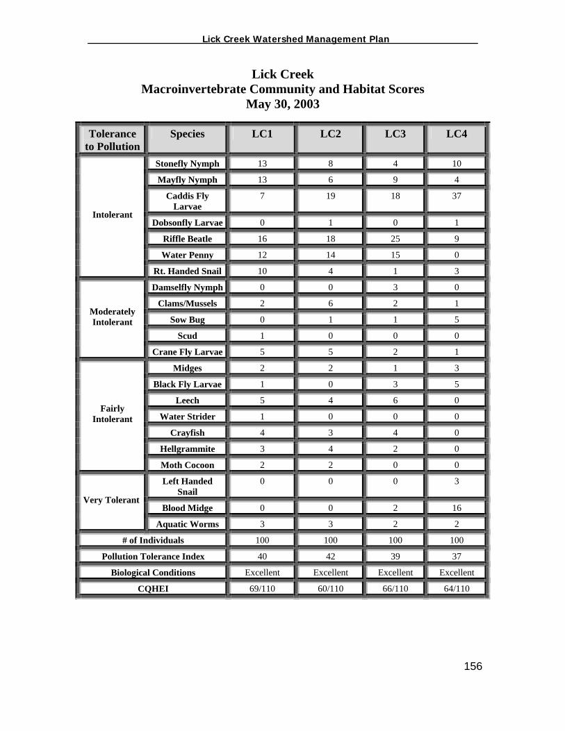
_________________ Lick Creek Watershed Management Plan_______________
Lick Creek Macroinvertebrate Community and Habitat Scores
May 30, 2003
Tolerance to Pollution
Species LC1 LC2 LC3 LC4
Stonefly Nymph 13 8 4 10
Mayfly Nymph 13 6 9 4
Caddis Fly Larvae
7 19 18 37
Dobsonfly Larvae 0 1 0 1
Riffle Beatle 16 18 25 9
Water Penny 12 14 15 0
Intolerant
Rt. Handed Snail 10 4 1 3
Damselfly Nymph 0 0 3 0
Clams/Mussels 2 6 2 1
Sow Bug 0 1 1 5
Scud 1 0 0 0
Moderately Intolerant
Crane Fly Larvae 5 5 2 1
Midges 2 2 1 3
Black Fly Larvae 1 0 3 5
Leech 5 4 6 0
Water Strider 1 0 0 0
Crayfish 4 3 4 0
Hellgrammite 3 4 2 0
Fairly Intolerant
Moth Cocoon 2 2 0 0
Left Handed Snail
0 0 0 3
Blood Midge 0 0 2 16 Very Tolerant
Aquatic Worms 3 3 2 2
# of Individuals 100 100 100 100
Pollution Tolerance Index 40 42 39 37
Biological Conditions Excellent Excellent Excellent Excellent
CQHEI 69/110 60/110 66/110 64/110
156