FAO Characterisation of Global Heritage … Characterisation of Global Heritage Agroforestry Systems...
82
FAO Characterisation of Global Heritage Agroforestry Systems in Tanzania and Kenya Aichi Kitalyi, Robert Otsyina, Charles Wambugu, and Deborah Kimaro Kihamba system a traditional Agroforestry system, Shimbwe Juu Kilimanjaro region: Photo by David Boerma. January 2013 Agro Forestry and Development Alternatives (AFOREDA), Tanzania Greener landscapes, healthier ecosystems, better life for all.
Transcript of FAO Characterisation of Global Heritage … Characterisation of Global Heritage Agroforestry Systems...

FAO Characterisation of Global Heritage Agroforestry Systems in Tanzania and Kenya
Aichi Kitalyi, Robert Otsyina, Charles Wambugu, and Deborah Kimaro
Kihamba system a traditional Agroforestry system, Shimbwe Juu Kilimanjaro region:
Photo by David Boerma.
January 2013
Agro Forestry and Development Alternatives (AFOREDA), Tanzania Greener landscapes, healthier ecosystems, better life for all.

Contents 1. Introduction .......................................................................................................................................... 6
1.1 Globally Important Agricultural Heritage Systems (GIAHS) ................................................ 6 1.2 Traditional Agroforestry in GIAHS concept ................................................................................... 8 1.3 The Scope of Work ...................................................................................................................... 10 1.4 Study Approach ........................................................................................................................... 11
2.0 Traditional Agroforestry systems in Tanzania ................................................................................. 11 2.1 General Overview ....................................................................................................................... 11 2.2 Chagga Home Garden System in Northern Tanzania .................................................................. 13 2.3 MATENGO NGORO-PIT SYSTEM .................................................................................................. 28 2.4 Ngitili agroforestry system in Western Tanzania ........................................................................ 36 2.5 Spice agroforestry system ........................................................................................................... 45
3 Traditional Agroforestry Systems in Kenya ......................................................................................... 49 3.1 Overview ..................................................................................................................................... 49 3.2 The Case Study of Central Kenya Highlands ............................................................................... 51 3.3 Values and Benefits of Traditional Agroforestry Systems .......................................................... 57 3.4 Contribution of Traditional Agroforestry Systems in Climate Change Adaptation and Mitigation
60 3.5 The Value and Role of Some Indigenous Tree Species ............................................................... 61 3.6 Distraction of Traditional Agroforestry Systems ......................................................................... 62 3.7 The Current Trends in Promotion of Agroforestry Practices ...................................................... 69 3.8 Challenges in Traditional Agroforestry Practices ........................................................................ 72 3.9 Opportunities in Traditional Agroforestry Systems .................................................................... 74
4. Conclusions and Recommendations ................................................................................................... 765. Bibliography ........................................................................................................................................ 77
List of Tables.
Table 1 Attributes of agroforestry systems within the GIAHS criteria and World Heritage
Standards. ................................................................................................................................................. 10 Table 2. Effects of conservation practices and slope on seasonal soil loss at Tukuzi, Mbinga
District ........................................................................................................................................................ 32

List of Figures.
Figure 1: Potential sites for traditional agroforestry systems in Tanzania ....................................... 12
Figure 2: Distribution of the Chagga home gardens on Kilimanjaro based on a supervised
classification of Landsat ETM images taken on 29 January and 21 February 2000 (Hemp and
Hemp, 2008) ............................................................................................................................................. 14
Figure 3: Vegetation Profile (Top 27 x 2.5 m) and ground plan (27 x 5 m; bold lines indicate the
area used for the profile) of a typical Chagga home garden in Kidia area in Old Moshi at 1400 m
asl. at 1400 m a.s.l. .................................................................................................................................. 16
Figure 4: Growth form spectrum of the Chagga home gardens; (a) species number of the
respective stratum in the vegetation plots; (b) species number of all representatives of a growth
form, e.g. of trees including young trees occurring in the shrub and herb layer or e.g. of herbs
excluding young trees etc. ( Hemp, 2006)............................................................................................ 17
Figure 5: a) Floristic composition of the banana fields in respect of the different vegetation
formations on Kilimanjaro; b) share of cultivated, neophytic and indigenous plants in the Chagga
home gardens. (Hemp, 2006) ................................................................................................................ 18
Figure 6 Poor land management a threat to the Chagga home gardens. Shimbwe juu upland farming ... 23
Figure 7 Vanilla plants in Chagga homegardens in Shimbwe Juu: Photo by David Boerma - FAO GIAHS
project ......................................................................................................................................................... 27
Figure 8 Map showing Mbinga District ....................................................................................................... 29
Figure 9 A profile of Ngoro ridges ............................................................................................................... 31
Figure 10 A cross section of a typical Ntambo agroforestry system along the catena............................... 34
Figure 11 The Map of Africa and Tanzania inset showing the distrcits of Shinyanga Region..................... 38
Figure 12 Tree composition of Ngitilis from various districts in Shinyanga. ............................................... 40
Figure 13 Traditional bee hives in Ngitili system ........................................................................................ 42
Figure 14 Spice Agroforestry system in East Usambara Tanzania .............................................................. 48
Figure 15 Smallholder farming system in Central Kenya Highlands ........................................................... 49
Figure 16 A Map showing some of the Identified Traditional Agroforestry Systems in Kenya ...... 51
Figure 17. A Map showing Traditional Agroforestry Systems in Central Kenya .............................. 53
Figure 18 Intensive Multi-layer Traditional Agroforestry System at the slopes of Mount Kenya .............. 57
Figure 19 A large tract of land under coffee mono crop ............................................................................ 64

Acronyms and Abbreviations
AIDS Artificially Induced Deficiency Syndrome
ASAL Arid and Semi-Arid Lands
BMELV Federal Ministry of Food, Agriculture and Consumer Protection - German
CAADP Comprehensive African Agricultural Development Programme
CBD Coffee Berry Disease
CLK Coffee Leaf Rust
CSD Commission on Sustainable Development
DDC District Development Committees
DRC Democratic Republic of Congo
FAO Food and Agriculture Organization of the United Nations
GEF Global Environmental Facility
GIAHS Globally Important Agricultural Heritage System
GTZ Deutsche Gesellschaft für Technische Zusammenarbeit (German
Technical Cooperation)
HASHI Hifadhi Aridhi Shinyanga (Soil Conservation Project – Shinyanga Region)
ICIPE International Centre for Insect and Pest Epidemiology
ICRAF International Centre for Research in Agroforestry (now World Agroforestry
Centre)
JICA Japan International Cooperation Agency
KARI Kenya Agricultural Research Institute
KEFRI Kenya Forestry Research Institute
KEPHIS Kenya Phytosanitary Inspectorate Service
KFS Kenya Forest Service
KNCU Kilimanjaro Native Cooperative Union
KWAP Kenya Woodfuel and Agroforestry Programme
NGOs Non Governmental Organizations
REDD Reduced Emissions from Degradation and forest Degradation
SIDA Swedish International Development Agency
TACRI Tanzania Coffee Research Institute

UNEP United National Environment Programme
UNESCO United Nations Educational, Scientific and Cultural Organization
UNFCCC United Nations Framework Convention on Climate Change
URT United Republic of Tanzania
WSSD World Summit on Sustainable Development

1. Introduction
1.1 Globally Important Agricultural Heritage Systems (GIAHS)
The dynamic conservation of Globally Important Agricultural Heritage Systems
(GIAHS) was conceptualized and introduced during the World Summit on Sustainable
Development (WSSD) in 2002. It was later registered by the Partnerships for
Sustainable Development that operates under the Commission on Sustainable
Development (CSD) in 2004. The overall goal of the partnership is to identify, support
and safeguard Globally Important Agricultural Heritage Systems and their agricultural
systems and associated biodiversity, knowledge systems, landscapes and cultures,
through catalysing and establishing a long-term programme to support such systems
and enhance global, national and local benefits derived through their dynamic
conservation, sustainable management and enhanced viability.
The salient features of GIAHS are their high degree of biodiversity. FAO 2002 defined
GIAHs as “Remarkable Land Use Systems and landscapes which are rich in biological
diversity evolving from the co-adaptation of a rural community/population with its
environment and its needs and aspirations for sustainable development”. Five main
criteria are used in identifying GIAHs namely:
Food and livelihood security: contributing to food and livelihood security of local
communities (often indigenous), representing the majority of their livelihood
provisions.
Biodiversity and ecosystem function: Endowed with globally (or nationally)
significance biodiversity and genetic resources for food and agriculture (e.g.
endemic, rare, endangered species of crops and animals)
Knowledge systems and adapted technologies:
Cultures, values systems and social organisation
Remarkable landscapes and water resource management
In 2008, with financial support from the Federal Ministry for Agriculture, Food Security
and Consumer Protection of the Government of Germany (BMELV), FAO initiated the

project “Supporting Food Security and Reducing Poverty in Kenya and Tanzania
through Dynamic Conservation of Globally Important Agricultural Heritage Systems
(GIAHS)". Two years running, in 2008 the project identified the Maasai pastoral
systems and Upland Agro-forestry systems as the most creative form of livelihoods
that have withstood the test of time and deserving recognition as heritage agricultural
systems of global importance and hence requiring support. This recognition was
followed by a pilot site selection mission led by the Project Facilitating Team, which
targeted three main agro-systems namely; the Chagga home gardens, the Pare Ndiva
system and the Matengo pit system. The evaluation team ended up ranking the Uru-
Shimbwe Juu site within the Chagga home gardens as the most integral Upland
agrosystem, in which all the critical heritage features are represented and associated
with this system. Probably of much relevance in the GIAHS concept here is the fact
that the Chagga home gardens represent one of the highly recognised traditional
agroforestry systems.
In 2011, the Project Facilitating Team recommended commissioning of a study to
undertake characterisation of the agroforestry systems of Tanzania and Kenya, to
support the East Africa GIAHs project in two main areas:
Implementation of the action plan for the dynamic conservation of the selected
project area and the mainstreaming of GIAHS goals and principles into national
policy.
Implementation of recommendation 5 of the 2011 project Independent External
Evaluation, which reads:
“in order to contribute to the up scaling of the GIAHS concept, it is recommended that
a structured review of pastoralist and agroforestry systems in eastern Africa be carried
out so that the globally important features identified by the project in Kenya and
Tanzania can be placed in the broader context of the region. In addition, it is
recommended that the project develops both spatially-explicit and feature specific
contextualisation of the selected sites, which can be used to better describe and
document the relevance, impacts and sustainability of GIAHS and the selected
systems”.
This paper addresses one of the components highlighted by the Independent
Evaluation team, i.e. agroforestry with emphasis on upland agroforestry. The pastoral
system as a potential GIAHS will be addressed in a parallel study.
1.2 Traditional Agroforestry in GIAHS concept Agroforestry practice is an age old land use practice defined as land use systems in
which woody perennials (trees, shrubs, palms, bamboo etc.) are grown on the same
piece of land with herbaceous plants and/or animals, either in spatial arrangement or
in time sequence and in which there are both ecological and economic interactions
between the trees and non-tree components (Beets, 1989). A more recent definition
embracing the global twin challenges of poverty and environmental degradation define
agroforestry as a dynamic, ecologically based, natural resource management system
that, through integration of trees on farms and in the agricultural landscape, diversifies
and sustains production for increased social, economic and environmental benefits for
land users at all levels (Leakey, 1996).
The diversified agroforestry systems help in sustaining agricultural production, improve
household food security and incomes. They also contribute towards environmental
and social benefits. Traditional agroforestry systems at some sites contain 50–80% of
the plant species diversity found in comparable natural forests while providing most of
the products needed by local families (Huang et al 2002). From a territorial point of
view, an agroforestry system is a unit of interdependence between a community and
its environment, where social and spatial boundaries ideally coincide. A territory
typically embodies all the necessary environmental and socio-cultural elements and
processes to constitute it as an integral unit for site selection and for ensuring its
dynamic conservation. The concepts of territory and integrity thus guide the site
delineation and some of the criteria used in site delineation include: outstanding
biodiversity, landscape and socio-cultural characteristics, social-environmental
balance and resilience, historical and contemporary relevance, being representative or
unique in nature.
Traditional agroforestry systems support a high degree of plant diversity in form of
crops, tree and fodder species. The underlining strategy of planting several species
and varieties of crops is to maximize risks and stabilize yields over the long term,
promote diet diversity and maximizes returns even with low levels of technology and
limited resources (Harwood 1979).to minimize risk. Traditional agroforestry systems
are very common on the East African landscapes spreading in most parts of the
highlands of Kenya, Uganda, Tanzania, Rwanda and Burundi. All of them have
common characteristic of plant diversity carefully selected and arranged in layers
(comparable to different flats in a storey building); a system that minimizes competition
between different plant species and optimizes land productivity.
Important to note that traditional agroforestry systems vary in their characteristics and
challenges; therefore each of them requires specific interventions. They are
irreplaceable, support biodiversity and have been proven to be environmentally
sustainable. For centuries, the systems have supported not only the livelihoods of
practicing communities but also a significant population along the value chain of the
products and services emanating from them. There is evidence that these systems
contribute tremendously towards the mainstream national economies. A conservative
estimate of international trade of agroforestry products gave a whopping figure of
UAD140billion in 2009 (Place et. al. 2009). Furthermore agroforestry systems assist
farmers to spread risks and their cumulative benefits are likely to be much higher than
alternative systems. These systems also contribute towards climate change
adaptation and mitigation through carbon sequestration by the trees and other
perennials in the system. Table 1 describe the main attributes of agroforestry systems
within the GIAHS criteria and World Heritage Standards.
– .

10
Table 1 Attributes of agroforestry systems within the GIAHS criteria and World Heritage Standards.
GIAHS criteria Agroforestry products and services
Peoples livelihoods and Food Security
Tree products in AF systems such as coffee, fruits and tree nuts contribute significantly to livelihoods of millions of low income people.
Well managed Af systems maintain soil fertility and thus contributing to increased food production.
Conservation and sustainable use of fauna and flora
Most traditional agroforestry systems are reach in fauna and flora. The Chagga home gardens described in more details below is reported to carry over hundred plant species in farms ranging from 0. 2-1.2 ha. The Chagga home gardens also carry high diversity of birds and insects.
Provision of habitats for wild biodiversity
Micro-climate created by agroforestry provide a conducive environment for wild biodiversity
Repository of local/indigenous knowledge on crop and animal husbandry
Agroforestry systems maintained through inter-generational transfer of knowledge and experience
Provision of ecosystem services and contribution to ecosystem health and capacity to adapt and mitigate climate change
The high ground cover of agroforestry systems sustains soil health through improved soil and water conservation, thus reducing crop failure risks from water stress.
1.3 The Scope of Work The study specifically involved:
• Characterization of heritage agroforestry systems in Tanzania and Kenya
• Highlight of geographical locations of heritage agroforestry systems in the two
countries

11
• Presentation of the findings to national policy workshops in Kenya and in Tanzania
• Production and submission of the final report including inputs from the policy
workshops.
1.4 Study Approach The study involved review of project documents and related literature on agroforestry
practices and particularly in the project selected sites in the two. It also included
consultations with key informants such as the community elders and agroforestry
experts in the government and NGOs who have decades of experience promoting
agroforestry practices in the countries. A checklist was developed to guide the
collection of information from key informants. The key areas of focus included; socio-
cultural and biodiversity characteristics of the traditional systems, environmental
sustainability and relevance to the ecosystem, economic relevance and resilience to
climate change. The study involved field visits and meeting the local communities.
Personal observation of current agroforestry practices guided the “face-to-face
interviews”. The local community provided valuable inputs. The preliminary findings
were presented in the national policy workshops held at UNEP headquarters in
Nairobi, Kenya 4 – 5th December 2012 and the Ubungo Plaza in Dar es Salaam 6 – 7th
December 2012. Feedback from the workshop participants helped in the synthesis
and compilation of the final report. Personal experience and field observations was
also handy in understanding the concept of traditional agroforestry systems. Spatial
mapping of the traditional agroforestry systems was guided by the information
gathered from key informants and the literature review.
2.0 Traditional Agroforestry systems in Tanzania
2.1 General Overview In Tanzania the GIAHS Project Facilitating Team identified three farming systems as
potential sites for heritage agricultural systems;
Kihamba sytem, popularly known as Chagga home gardens
Pare Ndiva system

12
Ngoro or the Matengo pits in Mbinga district.
Review of literature suggested other potential sites such as spice agroforestry
systems in the Eastern Arc Mountains and Zanzibar, the Maize-Faidherbia system in
Southern Tanzania, as well as the traditional silvipastoral system “Ngitili” in Western
Tanzania (Figure 1). The Kihamba system or the Chagga home gardens can be
described as a multi-strata system, which is found in High plains and Mountain blocks
as well as the Volcanoes & rift depressions ecological zones. The multi-strata
agroforestry systems overlap with the spice agroforestry systems mostly in the
highlands of Tanzania (Fig 1). The Nyarubanja system in Kagera region fall within the
multi-strata system.
Figure 1: Potential sites for traditional agroforestry systems in Tanzania

13
While the Kihamba system or the home gardens is characterised by more forest
features with multi-layered vegetation structure, the uniqueness of the “ndiva” system
is the traditional water harvesting system and for the matengo pits is a combination of
soil and water management. Since the present study focuses on upland agroforestry
systems, a detailed description of the Chagga home gardens, the pilot area for the
East Africa GIAHS project, is presented. For the other GIAHS systems highlights on
geographical location, structural features and economic importance are presented.
2.2 Chagga Home Garden System in Northern Tanzania
Historical Perspectives and geographical location of Chagga Home gardens
Humans have continuously inhabited the slopes of Mt. Kilimanjaro for the last 2000
years. However, during the last decades the human population increased dramatically
and it is estimated that the population on the mountain has multiplied 10 times within
90 years, from 1913 to 2002 (Hemp and Hemp, 2008 ). Most of the population is
concentrated at an altitude between 1000 and 1800 meters, with densities varying
from 500 to 1000 people per km2 in some areas. Over the years, the inhabitants of the
highlands in Kilimanjaro region have traditionally developed and refined a most unique
farming system well suited to the local conditions. The system is known as the
Chagga home garden or the Kihamba system (Fernandes et al., 1984). It is believed
that the first home gardens and traditional water canals existed already in the 12th
century. This old land use system has formed the identity of the Chagga, who are of
multi-ethnic origin, despite the fact that they belong to the Bantu people (Hemp and
Hemp, 2008).
By 1984, the Chagga home gardens were estimated to cover 120,000 ha on the
southern and eastern slopes of Mt. Kilimanjaro mainly between 900 and 1800 m
above sea level, stretching on the climatically most favourable zone of the southern
and south-eastern slopes (Figure. 2). The home garden has been sustaining natural
resources and the livelihoods of people on the mountain Kilimanjaro for many years.
However, recently the sustainability of this system has been greatly affected by the
increasing population pressure, lower economic returns of coffee once the backbone
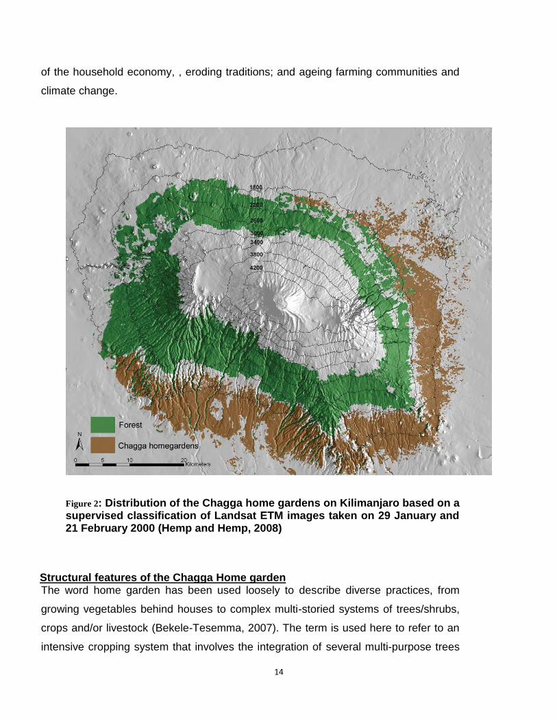
14
of the household economy, , eroding traditions; and ageing farming communities and
climate change.
Figure 2: Distribution of the Chagga home gardens on Kilimanjaro based on a supervised classification of Landsat ETM images taken on 29 January and 21 February 2000 (Hemp and Hemp, 2008)
Structural features of the Chagga Home garden
The word home garden has been used loosely to describe diverse practices, from
growing vegetables behind houses to complex multi-storied systems of trees/shrubs,
crops and/or livestock (Bekele-Tesemma, 2007). The term is used here to refer to an
intensive cropping system that involves the integration of several multi-purpose trees

15
and shrubs with food and cash crops and livestock on the same unit of land. These
components are managed as a single unit (system) using the family labour. Within the
cropping system, several agro-forestry practices can be identified, including the use of
multipurpose trees and shrubs to provide shade for coffee, fodder, timber and
firewood and as live fences.
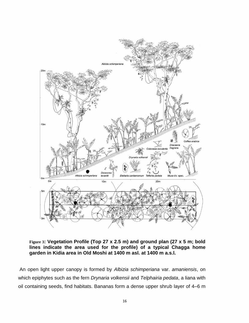
The chagga home garden is a typical agrisilvicultural system characterized by a
multilayered vegetation structure similar to a tropical montane forest with trees,
shrubs, lianas, epiphytes and herbs (Figure 3 and Figure 4). This forest-like structural
arrangement of plants mainly consists of the shade trees, the major cash crops coffee
(Coffea arabica) and banana grown for food and sale. In order to meet their shade
requirements, these agricultural crops are intimately intermixed in a complex
arrangement with a higher canopy of indigenous or planted multipurpose trees. There
is also a middle canopy of fruit and multipurpose trees/shrubs; followed by a lower
ground cover of food crops, medicinal plants and annual fodder plants (OK’tingati and
Kessy, 1991). Apparently, the vertical stratification of home garden as noted here
provides a gradient in light and relative humidity, which creates different niches for
enabling various species groups to exploit them. Obviously, shade tolerant crops
constitute the lower stratum, shade intolerant trees the top layer, and species with
varying degrees of shade tolerance in the intermediate strata (Kumar and Nair, 2004).
16
Figure 3: Vegetation Profile (Top 27 x 2.5 m) and ground plan (27 x 5 m; bold lines indicate the area used for the profile) of a typical Chagga home garden in Kidia area in Old Moshi at 1400 m asl. at 1400 m a.s.l.
An open light upper canopy is formed by Albizia schimperiana var. amaniensis, on
which epiphytes such as the fern Drynaria volkensii and Telphairia pedata, a liana with
oil containing seeds, find habitats. Bananas form a dense upper shrub layer of 4–6 m

17
height, coffee trees a lower shrub layer of 1.5–2 m, intermingled with 1–1.5 m high
Coco Yam (Colocasia esculenta). The lower side of the banana field borders a road;
here Dracaena fragans is planted as a hedge. (Hemp, 2006).
Figure 4: Growth form spectrum of the Chagga home gardens; (a) species number of the respective stratum in the vegetation plots; (b) species number of all representatives of a growth form, e.g. of trees including young trees occurring in the shrub and herb layer or e.g. of herbs excluding young trees etc. ( Hemp, 2006)
Agro-biodiversity conservation in Chagga home gardens
Although highly influenced by human habitation, tropical home gardens are important
repositories of high diversity of plant and animal species in farmlands (Agrobiodiversity).
Recent studies (Hemp, 2006; Hemp and Hemp, 2008) indicate that most plant species
in the home garden are forest species, followed by ruderal species (i.e. species on road
sides, waste places and fallow arable land) and cultivated species (Fig. 5a). Overall
indigenous species contribute over 70% of the species found in the home garden (Fig
5b). It is estimated that forest species in home garden contribute about 17% of the
forest plants of Kilimanjaro, demonstrating high conservation value of home gardens.
Some forest plants (e.g. Pilea tetraphylla) were only found in the home garden

18
highlighting the important conserving function for species at risk of extinction. Forest
related tree species common in the home garden include remnants of the former forest
cover like Albizia schimperiana, Rauvolfia caffra, Cordia africana, Commiphora eminii
and Margaritaria discoidea. There are also introduced timber trees such as Grevellia
robusta and Cupressus lusitanica and fruit tree species such as Persea americana,
Mangifera indica and Syzygium cumini.
Figure 5: a) Floristic composition of the banana fields in respect of the different vegetation formations on Kilimanjaro; b) share of cultivated, neophytic and indigenous plants in the Chagga home gardens. (Hemp, 2006)
(a)
(b)

19
The Chagga home gardens also are an important habitat for animal species. Saltatoria
is one of the widely studies fauna species in the Chagga home garden. It is estimated
that 52 species, about a quarter of the whole Saltatoria fauna in Kilimanjaro Mountain,
are found in the home garden (Hemp, 2006; Hemp and Hemp, 2008). Over 70% of the
Saltatoria species found in the Chagga home gardens originate from forest communities
and the remainder are open land forms; this indicate that home garden are also a refuge
of animal species. Apparently high diversity of plant and animal species in Chagga
home gardens reflect a variety of habitats like, cultivated areas, forest patches and river
gorges found in this system. Similarly various studies elsewhere affirms that diversity
indexes in home gardens are comparable with that of adjacent forest formations and
plays a key role in sustainability and provision of ecosystem services, such as food,
fodder and firewood; fertilize soil, carbon sequestration, etc. (Kumar and Nair, 2004).
Household Food and Income Securities from Chagga Home gardens Operationally, tropical home garden are mainly subsistent, except for those with cash
crops like coffee and cocoa; hence their primary function is food production. Food crops
and fruits trees, especially, banana (Musa spp), guava and avocado are an important
component of Chagga home garden providing food throughout the year, minimizing the
need to store food for a long period where there is also the risk of post-harvesting
losses. Beside food supply, different crops and livestock such as sheep, goats, cattle
etc., from home garden, contribute to improved households nutrition. Diversified planting
and harvesting time of food crops and fruits trees are the key elements for home
garden’s contributions to household food and nutrition security. Limited information is
available on the nutritional value of Chagga home gardens. However, experiences from
other places suggests, that home gardens hold high potential to provide 3 to 44% of
total calories and 4 to 32% of total protein intake. Even though home gardens may
seldom meet the entire basic-staple-food needs of the family in any given area, at best,
they are complementary to other food sources (Kumar and Nair, 2004). Beside crop
production, the tree layers provides people with fire wood, fodder and timber and
sustain soil productivity through nutrient recycling processes and by reducing soil
erosion and the impacts of other degrading factors.

20
Surplus food production can be sold to generate income and thus contributing to the
household income security. The net income generated from home gardens is very
variable and depends on species composition. For example, percent contribution of
home garden to total family income ranged from 7% to 56 % of the total income
household income in Indonesia and Vietnam (Trinh et al. 2003; Kumar and Nair, 2004).
For many years coffee and banana have been sustaining the livelihoods of farmers in
northern Tanzania, making Kilimanjaro region one of the richest and well educated
regions in the country until 1990s when the trend reversed for reasons discussed below.
Wood Supply and Mitigation and Adaptation benefits of Chagga home gardens While there are many reports on food and nutritional security, relatively few workers
have addressed questions relating to wood production and its utilization in the home
gardens. Indeed this seems to be an unrecognized value of many tropical home
gardens including the Chagga home gardens. Local communities over the years have
almost entirely relied on home garden for household cooking energy supply from trees
planted or naturally regenerated in this system. It is estimated that a Chagga home
garden supplies 1/4 to 1/3 of the fuelwood requirements of a family (Fernandes et al.
1984). Apart from indigenous shade trees, Grevillea robusta, is a one of the classical
example of an exotic tree introduced for productions of timber and poles in Chagga
home gardens. On-farm wood production has great potential to offset carbon emissions
through avoided deforestation and if financing mechanisms to account for this carbon
are well developed, this practice could help farmers to actively participate in climate
change mitigation while generating income to adapt to the impacts of climate change
and reducing land degradation (Kimaro et al., 2011; Robiglio et al., 2011).
Understanding on-farm wood (fuelwood, timber, poles etc.) production capacity of
Chagga home garden and household consumption patterns is a critically needed to
assess the impacts of this on carbon sequestration and reducing harvesting pressure on
native forests (Kimaro et al., 2011; Robiglio et al., 2011).

21
The forest-like structure of Chagga home garden discussed earlier presents a unique
opportunity for carbon sequestration, while maintaining food crop and wood harvesting
requirements of individual farmers. Traditionally this has been done through selective
wood harvesting that do not involves complete removal of tree cover largely satisfying
conditions of carbon leakage and permanence for carbon offset projects.. But
comprehensive policy and regulations which consider landscape based carbon
accounting approaches are needed to promote carbon as a value-added product for
improving climate change adaptive capacity of farmers, while reducing degradation of
coffee agroforests and enhancing food crop production.
Threats and opportunities of Chagga Home gardens It was established in the previous sections that Chagga home gardens provide various
human needs including income, food, energy, and construction materials. The
complimentarity in subsistence and cash crops, and the diversity of the food crops
enhance food and nutrition security and household income, contributing to
socioeconomic sustainability of this system. Shade and fruits trees also increase family
income from products like fruits, fuelwood, timber, and medicine. They also contribute to
ecological sustainability of Chagga home gardens thorough efficient nutrient cycling and
microclimate (soil moisture and relative humidity) modifications (Kumar and Nair, 2004).
However, changes in biophysical and socio-economic conditions in Chagga home
gardens over the years are endangering the sustainability of this system. These
changes include decreasing farm size resulting from population growth and introduced
alternative cash and food crops due to dwindling coffee prices (Hemp, 2006).
Cash and food crops like vanilla, maize and vegetables are gradually replacing the
coffee-banana systems in Tanzania. As noted here, changes in socio-economic and
biophysical conditions lead to the decline in composition and density of keystone
species (i.e., shade trees coffee, and banana,), affecting food production, people’s
livelihood, and the environmental sustainability of the Chagga home garden system as a
whole. This is because density and composition of keystone species determine the
22
ability of multistrata systems to recycle nutrients and modify microclimate and soil
moisture conditions to influence crop production as well as supply of food and other
products discussed earlier. Hence, we conducted a field visit to discuss trends, threats
and opportunities of Chagga home garden with key informants and farmers in Moshi
rural districts. The field reported was complimented with literature review to understand
the major threats of home garden over the years and opportunities for reviving this
system to sustain its cultural and ecological heritage as detailed in this section
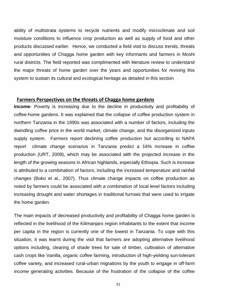
Farmers Perspectives on the threats of Chagga home gardens
Income- Poverty is increasing due to the decline in productivity and profitability of
coffee-home gardens. It was explained that the collapse of coffee production system in
northern Tanzania in the 1990s was associated with a number of factors, including the
dwindling coffee price in the world market, climate change, and the disorganized inputs
supply system. Farmers report declining coffee production but according to NAPA
report climate change scenarios in Tanzania predict a 16% increase in coffee
production (URT, 2009), which may be associated with the projected increase in the
length of the growing seasons in African highlands, especially Ethiopia. Such is increase
is attributed to a combination of factors, including the increased temperature and rainfall
changes (Boko et al., 2007). Thus climate change impacts on coffee production as
noted by farmers could be associated with a combination of local level factors including
increasing drought and water shortages in traditional furrows that were used to irrigate
the home garden.
The main impacts of decreased productivity and profitability of Chagga home garden is
reflected in the livelihood of the Kilimanjaro region inhabitants to the extent that income
per capita in the region is currently one of the lowest in Tanzania. To cope with this
situation, it was learnt during the visit that farmers are adopting alternative livelihood
options including, clearing of shade trees for sale of timber, cultivation of alternative
cash crops like Vanilla, organic coffee farming, introduction of high-yielding sun-tolerant
coffee variety, and increased rural-urban migrations by the youth to engage in off-farm
income generating activities. Because of the frustration of the collapse of the coffee
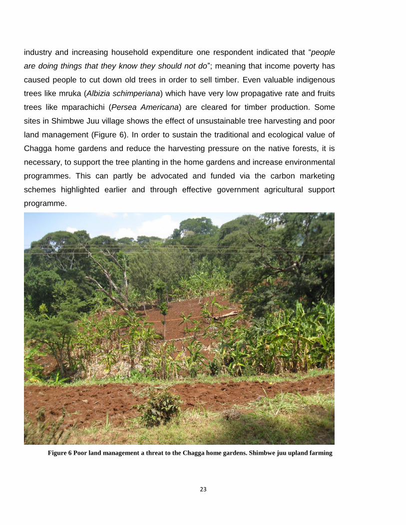
23
industry and increasing household expenditure one respondent indicated that “people
are doing things that they know they should not do”; meaning that income poverty has
caused people to cut down old trees in order to sell timber. Even valuable indigenous
trees like mruka (Albizia schimperiana) which have very low propagative rate and fruits
trees like mparachichi (Persea Americana) are cleared for timber production. Some
sites in Shimbwe Juu village shows the effect of unsustainable tree harvesting and poor
land management (Figure 6). In order to sustain the traditional and ecological value of
Chagga home gardens and reduce the harvesting pressure on the native forests, it is
necessary, to support the tree planting in the home gardens and increase environmental
programmes. This can partly be advocated and funded via the carbon marketing
schemes highlighted earlier and through effective government agricultural support
programme.
Figure 6 Poor land management a threat to the Chagga home gardens. Shimbwe juu upland farming
24
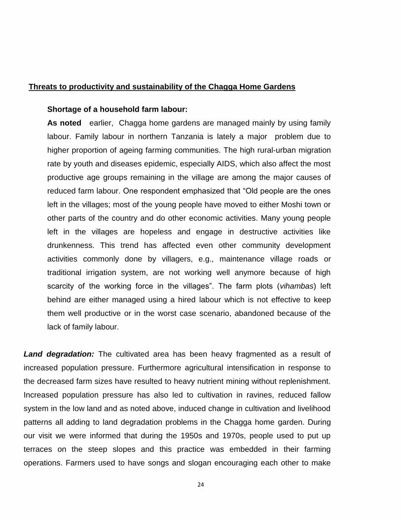
Threats to productivity and sustainability of the Chagga Home Gardens
Shortage of a household farm labour:
As noted earlier, Chagga home gardens are managed mainly by using family
labour. Family labour in northern Tanzania is lately a major problem due to
higher proportion of ageing farming communities. The high rural-urban migration
rate by youth and diseases epidemic, especially AIDS, which also affect the most
productive age groups remaining in the village are among the major causes of
reduced farm labour. One respondent emphasized that “Old people are the ones
left in the villages; most of the young people have moved to either Moshi town or
other parts of the country and do other economic activities. Many young people
left in the villages are hopeless and engage in destructive activities like
drunkenness. This trend has affected even other community development
activities commonly done by villagers, e.g., maintenance village roads or
traditional irrigation system, are not working well anymore because of high
scarcity of the working force in the villages”. The farm plots (vihambas) left
behind are either managed using a hired labour which is not effective to keep
them well productive or in the worst case scenario, abandoned because of the
lack of family labour.
Land degradation: The cultivated area has been heavy fragmented as a result of
increased population pressure. Furthermore agricultural intensification in response to
the decreased farm sizes have resulted to heavy nutrient mining without replenishment.
Increased population pressure has also led to cultivation in ravines, reduced fallow
system in the low land and as noted above, induced change in cultivation and livelihood
patterns all adding to land degradation problems in the Chagga home garden. During
our visit we were informed that during the 1950s and 1970s, people used to put up
terraces on the steep slopes and this practice was embedded in their farming
operations. Farmers used to have songs and slogan encouraging each other to make

25
terraces. It is a tradition among Chagga people to conserve the soil and sources of
water like springs, rivers etc. No one was allowed to cut a tree and trees like Ficus spp.,
which grown close or along these water sources and in catchment areas. However, the
new generation does not recognize the value of land and keep this tradition. People are
not putting the bench terrace anymore; they just plant on steep slopes leading serious
soil erosion and land degradation problems. There are by-laws from all levels of
government too on good soil and water conservation practices, but nowadays they are
not followed.
Cultural erosion: The Moshi Rural District Crop Production Officer Mrs. Joyce Kessy
had the opinion that the major problem in the management of the Kihamba system is
the eroding culture or attitude towards good agricultural practices as highlighted above.
She noted that in the context of this system in Kilimanjaro the changes in people’s
attitudes, culture, and behavior could have more negative effects than climate change.
This analysis or perspective could suggest negative attitude may constraint behavioral
changes to adopt climate smart practices being advocated or revert to sustainable
traditions which have sustained the Chagga home garden system over the years
Opportunities and policy recommendations to revive Chagga home gardens
Key informants and farmers indicated the following opportunities and recommendations
to revive the Chagga home garden so as to sustain this traditional system in the context
of challenges discussed in this report.
Organic coffee farming
a) Organic soil fertility improvement procedures
Farmers are encouraged to improve coffee production using available resources
around their homesteads. They encourage proper manure management for soil
fertility. This is done by mixing the manure available from their livestock, crop
residues and kitchen wastes. This mixture is then buried down on the ground and
covered well since rain and sun have negative effects on the manure nutrients.
Organic coffee fetch higher prices in the global market which in turn a farmer is

26
paid the better price compared to the conventional Market. This is adding value
to what farmers have already in their field because most of them have failed to
secure inputs and equipment for proper coffee management.
b) Organic control of pests and diseases
Farmers have indigenous knowledge of controlling pests and diseases. The local
pesticide is made from utupa (Tephrosia vogelii) or muarobaini (Azadirachta
indica) and is used to repel stem borer, berry borer and other pests. What they
do is to tell farmers the proper measurements of the ingredients. For example in
order to get effective pesticide one should prepare Ikg of fresh leaves of
Tephrosia spp or A. indica mashed, mixed with 1lt of water and they are left
settle for the whole night. The following day the solution is diluted with water to
20lts and it is good for control of several pests and diseases. There is on-going
research at Tanzania Coffee Research Institute (TaCRI) on natural pesticides
and biological control of the berry borers, stem borrer and other coffee pests and
diseases which then will improve the control of coffee pests and diseases in a
more economical and environmental friendly manner.
Introduction of high value crops.
Introduction of high value crops is one of the interventions in the Chagga
homegardens to address the problem of low household income caused by the
failing of the coffee industry. Vegetable crops including tomatoes and cabbages
have replaced a number of coffee trees in the system. However, such crops have
had a negative effect, because they require more light and therefore indigenous
trees in the multi-strata system are cut down. Introduction of spices such as
Vanilla, which is one of the intervention introduced by the GIAHS project is
probably more environment friendly (Figure..). However, during the field visit
farmers indicated that there is need for more research on the husbandry, markets
and marketing of this crop. Potential for other spices such as cardamom as well
as high value fruits and nuts are some of the other opportunities.

27
Figure 7 Vanilla plants in Chagga homegardens in Shimbwe Juu: Photo by David Boerma - FAO GIAHS
project

28
Policy recommendations
1. Laws and regulations about soil and water conservation should be revisited and
enforced. For examples, everyone with corrugated iron sheet roof should have a plan to
collect the water in order to minimize soil erosion.
2. Soil and water conservation unit should be emphasized and be placed under president
office. Right now is under the ministry of agriculture but it has not received the required
attention.
3. The number of indigenous trees in a given area should be well defined in order to give
guidance and inform farmers on its importance. This can be achieved by conducting
research and establishing indigenous tree nurseries.
4. Follow up of laws and by laws should be done to ensure trees are planted and
maintained, also protection of the recommended distances from water bodies and water
catchment areas.
5. Women visibility should be raised in coffee production and Kihamba systems need to be
increased as currently coffee is still a men dominated cash crop. KNCU is currently
advocating on gender sensitive polies and guideline e.g. having female chairperson in
the primary societies.
6. Laws on cutting and planting trees in the farms, around water sources should be put
clear and emphasized
7. There should be a law for owners of vihamba living outside the villages to take care of
their vihamba if not consequences will follow
8. Beacons or any mark should be used to mark water sources as it is done for road
reserves.
2.3 MATENGO NGORO-PIT SYSTEM
Geographical location
The Livingstone Mountains are on the east coast of Lake Malawi, southern Tanzania.
The western part of the mountainous area in the Mbinga District, Ruvuma region is
called the Matengo Highlands (Fig 6), and is characterized by steep slopes ranging from

29
1,300-2,000m above sea level (asl). The indigenous vegetation of the Matengo
Highlands is primarily evergreen montane forest, with annual precipitation of 500-
1,200mm (JICA, 1998).
Figure 8 Map showing Mbinga District
The History of Matengo and Ngoro cultivation
The Matengo people have lived in the mountainous lands for more than a century and a
half, because of conflict with the Ngoni people who migrated from southern Africa to
30
east of Matengo Highlands, now called Songea, in the middle of the nineteenth century
(Willis,1966; Shillington, 1989). They were obliged to stay only on the upper areas of
mountains.
Due to high population pressure in those days they needed to increase yield per unit
area in order to obtain enough food. Under these social constraints to survive in the
highlands, the matengo invented intensified cultivation system with a unique soil
conservation features especially for food production. The system is called ngoro.
Literally translated, ngoro means “pit” in the Matengo language. Since a ngoro field has
many pits, the system has been referred to in the literature as “Matengo pit cultivation”
(Kato, 2001). The Ngoro system has sustained land productivity for many years and it is
estimated to start between 1700-1750 BC and covers an area of 18,000ha. The
population in the highlands is still high According to the 1957 census, the population
density of the Matengo Highlands was about 70 individuals/km2 (Tanganyika, 1963),
and in 1997 it was more than 100 individuals/km2 (JICA, 1998). This density is
considerably higher than the average 26 individuals/km2 in Tanzania in 1988 (Tanzania,
1989).
Description of the Ngoro farming system The plot is slashed and the grass including the crop residues are left to dry for about two
to three weeks. Then they are arranged in square shaped lines of about 2 m by 2 m
sizes. This job is done by men. The women job is to dig the pits, whereby the soil is dug
in the middle to cover the grasses and thus forming a series of ridges with pits in the
middle. This forms a honey comb like structure. Beans, wheat, finger millet, cowpeas
and maize are grown on the ridges surrounding the pits (Fig 7).

31
Figure 9 A profile of Ngoro ridges
The fertility of a ngoro field can be sustained by long fallow periods, as well as by short
fallow periods every two years. However, because of the high population density the
farmers must continue to cultivate their fields for a long time and in order to continue
getting high yields, they apply chemical fertilizers to grow maize (Kato, 2001).
Significance of the System
Economy and food security: The ngoro system is the most important way for the
Matengo to acquire food, and many of the farmers do not sell products from their ngoro
fields. Food production from ngoro farming is relatively higher Allan, 1965 mention of an
experiment which indicated that maize yields in ngoro were 3 times more than those of
a bench-terracing system. Most of the income in the Matengo economy is acquired
through coffee production. In 1926, coffee was introduced to the Matengo Highlands
and gradually spread throughout the area (Iliffe, 1979). Coffee is suited to the cool and
moist conditions of Mbinga. There is a close relationship between coffee production and
food crop production in Matengo highlands. Since coffee is the major cash crop the
income from coffee is used to buy fertilizer and other inputs for food production

32
Social-cultural: Ngoro cultivation has very deep roots in Matengo culture, especially
when it comes to marriage. Women must master the techniques of making the ideal and
perfect ngoro. They are aware that the skill of cultivating the ngoro is an index of their
socio-cultural status and recognition, particularly for unmarried women. Thus, the ngoro
cultivation system has also been maintained by the common recognition of women’s
labour and integrity. Division of labour in ngoro cultivation is strictly based on gender. If
either gender fails to perform its duty, the cultivation of ngoro may commence late or be
abandoned altogether. It is almost impossible to exchange labour between sexes in
ngoro cultivation, because men and women have mastered only one technique. (Kato,
2001)
Environment
Soil and water conservation: The system is very effective in controlling soil erosion;
the effects are comparable to bench terraces and more effective than ridges or bare
practices. The pits are very effective in collecting runoff water during the rain and to be
effectively utilized by crops grown on the ridges. Moisture conservation facilitated by
the ngoro pits creates a microclimate which allows beans planted towards the end of
the rains (March/April) to be cropped on residual moisture (Table 2)
Table 2. Effects of conservation practices and slope on seasonal soil loss at Tukuzi, Mbinga District
Site
Slope (degree)
Conservation practice
Soil loss (tons/ha) 1994/95
Soil loss (tons/ha) 1995/96
A 9 Bare 39.0 38.6
Ridge 7.3 3.0
Ngoro 2.4 1.2
B 21 Bare 55.7 80.6
Ridge 14.3 10.6
Ngoro 5.8 1.4
Source: Jica, 1998

33
The buried grasses and the crop residues on the ridges decompose to release nutrients
to the soil and subsequently to the grown crops.
During the rainy season, the ridges begin to collapse gradually and the pits are filled
with sediment by the middle of the rainy season. This is probably caused by a lack of
subsurface drainage due to decomposition of grass and crop residues on the ridges.
The decrease in permeability of water into the ridges may be ascribed to soil
compaction. During the season, erodible surface soils are deposited in the bottom of the
pit. Even if the size of one pit is small, the number of pits formed all over the field may
enhance soil sedimentation capacity by minimizing soil loss with run-off water. (Itani,
1998). The position of the pits is shifted for each new cultivation . New pits are placed
where the previous ridges intersected. By changing the position of the pits during each
preparation, the top and sub-soils as well as dry grasses are mixed or turned over
(JICA, 1998). This process matures the soil. Although the function of soil and water
conservation attracts the most notice in the ngorongoro system, soil maturing is also
quite important to maintaining high productivity levels.
Land Utilization on the Highlands
Matengo have a unique land tenure system called ntambo whereby families own pieces
of land from top of the mountain down to the valley. The elevation ranges from 100-600
m and the size of the ntambo can range from 10-70 ha. (Kato, 2001). Kitengo is the
upper parts of the mountains which is often a forest cover. The place is used for
firewood collection, grazing of animals, or collecting wild plants for herbal remedies.
People build houses on any flat site within their ntambo. This place is called nnduwi. Is
around this area where Matengo establish their home gardens (Fig 8). They plant
vegetables like tomatoes, onions, amaranth, sweet potatoes, sunflowers, pumpkins, and
other vegetables. Coffee trees are usually cultivated in bench terraces on the slopes
around this area. Coffee is grown on farms that are close to homesteads as it needs
close supervision and operations like pruning, spraying, picking and processing of the
ripe berries would be difficulty if farms were far. Trees such as Grevillea, Eucalyptus,

34
Cypress and fruit trees are interplant with coffee to form home garden agroforestry
system. (Nhira et al 2008).Uheleu, is the steep slope area in the ntambo, that’s where
the ngorongoro cultivation is done to grow the major food crops, maize and beans.
Kijungu and libindi fields are located down on the valleys on narrow, flat, elongated plain
along the streams. This area remains wet throughout the year and is used to grow some
vegetables and coffee seedlings. Perennial crops such as sugar cane, banana and taro
are grown here too. Plains are utilized for pasture during the dry season. Some farmers
do aquaculture on this place too.Thus, the Matengo use the ntambo effectively to suit
various ecological conditions.
Figure 10 A cross section of a typical Ntambo agroforestry system along the catena.
Challenges and Opportunities Threats: The system is labour intensive for women. Denser population and competing
land uses with coffee production and settlement expansion, shortage of labour, drought,

35
and climate change are the major constraints to sustainability of ngorongoro farming.
For instance shortage of family labour lead to the use of hired labour, which sometimes
do not make good pits and hence the system becomes ineffective.
Climate change its impact and adaption: Nindi S. and Mhando D.(2012 ) did a study
on the climate change and variability in Matengo highland and come up with the
following results. The study was done on two Matengo villages of Kindimba and
Kitanda, the following were noted as indicators for climate change, recurrent droughts,
El nino rains of 1997-1998, change of rainfall seasons (onset, offset, durations,
increasing dry spells) crop failures, increasing temperatures, outbreak of unusual pests
and diseases such as maize leaf rust in 1990s, declining soil fertility that forced
replacement of maize with cassava.
Their adaptive strategies include the following: working in farmers groups in order to
enhance intergrated resource management in activities like fish farming, beekeeping,
tree planting. Other strategies include rural –rural migration, adoption to improved
cooking stoves in order to cut down firewood consumption, intensive valley bottom
cultivation and change in eating habits. Others include intensification of agroforestry,
adoption of new coffee clones, cultivation of drought resistant crops like cassava and
engagement in other non-farm activities like poultry, pig, cattle husbandry and hydromill
machine. The stricking feature is the organization of farmers groups although adaption
at household level is practiced too. The farmers are enganged in other cash generating
activities like selling of fingerlings, fish vegetables and honey. The hydromill which is
owned under the farmers umbrella group generate revenues which are used for other
development activities in the village. Establishment of SACCOS (Saving and credit Co-
operative Societies) which helps farmers to access financial services and acquire loans
which helps to improve their livelihood.
Collapse of Coffee production
The collapse of the coffee market has negatively impacted the Matengo farmers. The
income from coffee was used to acquire chemical fertilizer which supported crop
production. Mhando (2005) noted that the tumbling of coffee production and it’s

36
marketing system led to the vast and abrupt creation of new farms on virgin lands on the
rolling hills where use of agro-chemicals was not necessary. This influx of immigrants
from the mountainous areas caused land degradation in the rolling hills since in the new
land farmers practiced slash and burn agriculture on such steep and rugged slopes and
cause intensive soil erosion and sediment run off to valleys Nindi. ( 2004) and
deforestation is another problem.
2.4 Ngitili agroforestry system in Western Tanzania
Geographical location and structural features The Ngitili,is a traditional silvopastoral pastoral system of the Sukuma tribe in western
Tanzania, especially in Shinyanga region. The Ngitili is system comprises livestock and
trees/vegetation components which are both managed together to generate social-
economic and environmental benefits. Under the Ngitili, communities set apart grazing
areas to serve as a reserve for supplying fodder during the dry season when supply is
limited. The Ngitili also provides wood and non wood products, medicines and food for
the households (Otsyina et al. 1997, Monela 2005).
The Ngitili System integrates livestock and crop production. Although the Ngitili
agropastoral system originated and mostly documented in Shinyanga, variations of the
Ngitili system are practiced by the Wanyaturu in Singida and parts of Tabora.
Shinyanga Region is situated in northwestern part of Tanzania, South of Lake Victoria at
about latitude 2 - 50 South and longitude 31 - 350 East. Mwanza, Kagera and Mara
regions to the North, Arusha Region to the East, Singida and Tabora regions to the
South and Kigoma Region to the West border the region.
The Region has eight administrative districts (Shinyanga Rural, Shinyanga Urban,
Maswa, Meatu, Kahama, Bukombe, Bariadi and Kishapu (Figure 10). Shinyanga Region
covers an area of 50,764 km2 of which 31,140 km2 is arable land, 12,079 km2 grazable
land and 7,544 km2 forest reserves (HASHI, 2002). Altitude varies between 1000 masl
in the southeast to 1500 m asl in the north-east. Ecologically the region falls under the
unimodal plateau. Mean annual rainfall is about 700 mm and it ranges from 600 mm in

37
the east to 1200 mm in the west (HASHI, 2002). Rains begin in November and end in
April/May. Rainfall is poorly distributed with high variability within and between seasons.
Monthly temperatures vary between 27.60C to 30.20C maximum and 150C and 18.30C
minimum. On hilltops, soils are moderately well drained greyish brown and sandy (ferric
acrisols and oxisols). Moderately deep well drained, greyish brown sand loams (ferric
luvisols) occur on the slopes. On the low-lying bottom lands, are the poorly drained
black clays (cambisols and vertisols). Vertic soils are very extensive covering 47% of all
soil types in the region. Natural vegetation was originally woodland and bushland with
species such as Acacia, Brachystegia, Albizia, Commiphora and Dalbergia (HASHI-
ICRAF, 1997).
Social-cultural characteristics Shinyanga Region is dominated by WaSukuma, an agropastoral community. Lesser
populated groups include WaSumbwa, and minorities from neighbouring Mara and
Kagera Regions. The region is experiencing a fairly high population growth that has
increased from 1,772,549 people in 1988 to 2,805,580 people in 2002 at a growth rate
of 2.9% per annum (National Population Census, 2002). Mixed farming is practiced
whereby cultivation is the major livelihood activity, followed by livestock keeping. Major
cash crops are cotton and tobacco. Other crops such as paddy, cassava and maize
serve both purposes of food and cash income.

38
Figure 11 The Map of Africa and Tanzania inset showing the distrcits of Shinyanga Region
Livestock keeping is very prominent and according to National estimates (2002)
Shinyanga region possesses the largest number of cattle head among all regions in
Tanzania. It is estimated that between 20-30% of the livestock population in the country
is found in Shinyanga (Machanya et al, 2003:4). Cattle are the traditional symbol of
wealth and status, are assets that can be converted to money, food and farm
implements, used for bride price, and source of family wealth and income’ (Shinyanga,
1998). Livestock wealth is thus a central component in maintaining people’s lifestyles. A
small percentage of people also practice artisanal and small scale mining. Despite
having much production potential, Shinyanga region was consistently identified as
poorer than the national average in terms of income poverty.
Structure, composition and biodiversity

39
The Ngitilis concept is based on conservation of natural resources for food security,
supply of wood and non wood resources as well as other household needs. Ngitilis
comprise trees forming the upper layer while grasses mixed with forbs form the other
lower layers. A great diversity in composition and will as sizes exists from district to
district depending on land availability, usage and climatic differences. Ngitilis in
Kahama are the most diverse. Dominant trees found on Ngitilis in each district are
indicated in the figure 11 below. Dominant tree species found on Ngitilis include,
Acacia tanganyikensis, Acacia polyacantha, Afzilia quanzensis, Brachystegia species,
Commiphora Africana, combretum zayeri and Dalbrgia melanoxylon.
Recent survey results ( Monela 2005) have documented over 152 different trees, shrub
and climber species in Ngitili forests and many bird species and insect eaters have re-
colonized habitats that were destroyed. Ngitilis also provide homes for small and
medium sized mammals. However, large mammals like elephant, buffalo, zebra that
require larger home ranges have disappeared in all districts except in protected areas.
In addition, Ngitili and woodlots provide fodder for livestock grazing during the dry
season. This simplifies the living standards of the livestock keepers because the
pastures are now nearby them, hence save time for other activities.
Management of the Ngitili system
The system is managed through careful grazing resource management and crop
husbandry practices. The Sukuma have developed ecologically based grazing
management practices to ensure sustainability of fodder and food throughout the year.
Some of these practices include controlled and deferred grazing of Ngitilis, adherence to
optimum stocking levels and times of grazing at specific areas. For example, wetlands
or Mbuga areas were reserved for grazing during the dry seasons. On crop lands, the
Sukuma practiced crop rotations, fallowing and specific crop mixtures to maintain soil
fertility and productivity as well and minimize disease incidences. The Ngitili
management systems were controlled and monitored by village and sub village by-laws
which were enforced by the Sungusungu or community police.

40
Figure 12 Tree composition of Ngitilis from various districts in Shinyanga.
Institutions and organizations

41
The wealth in indigenous institutions, knowledge and practices related to natural
resource management in Shinyanga has been well documented (Mlenge, 2002, Minja
and Machanya 2010). The strength of these institutions is still apparent today although
policy influences and changing socio-economic reality have influenced the evolvement
of institutional arrangements. Currently, most traditional systems of resource
management try to synchronize with modern challenges and demands on natural
resources in order to maintain a healthy resource base. Resource management is
organized and directed by informal traditional structures such as Baraza la Wazee, that
has significant clout in institutionalisation and enforcement of local rules and regulations
regarding Ngitili management. The local rules ensure that the valuable natural
resources for livestock and agriculture are not degraded but sustained. This traditional
knowledge is passed on to the younger generations.
Land use, ownership and tenure rights The Tanzania Land Law and Policy recognizes customary land tenure arrangements.
Thus land use patterns in the region are strongly influenced by Sukuma cultures and
traditions. These have established rights of access to resources, land use practices
such as bush fallow, and the predominance of livestock keeping. Women, who may not
automatically have ownership rights to the land, do at least have full control of low-
income crops while men control cash crops such as cotton, despite the shared labour
between the couples (op. cit, 2003:43). Traditional land use patterns are, however,
increasingly challenged by pressure on land because of increased livestock populations,
and human population increases leading to increased fragmentation. Decreasing soil
fertility is making farming unproductive but the farmers are not used to apply manure
despite its availability (Machanya, et al, 2003).
Economic activities The types of economic activities carried out in Shinyanga region are dependent on
climate and the existing natural resource base. Livestock keeping is second to crop
husbandry, the predominant economic activity in the region. More than 90 per cent of
the region’s population live in the rural areas and practice agro-pastoralism. The people
in Shinyanga region earn their living through a diverse range of activities. Subsistence
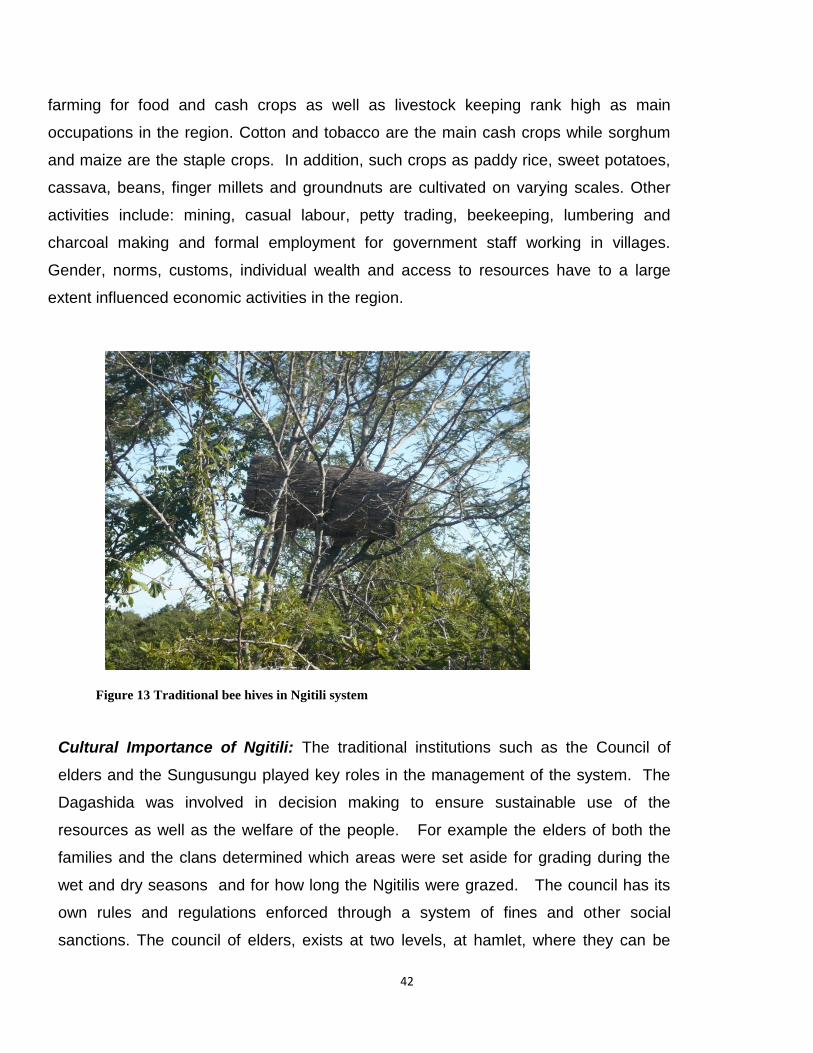
42
farming for food and cash crops as well as livestock keeping rank high as main
occupations in the region. Cotton and tobacco are the main cash crops while sorghum
and maize are the staple crops. In addition, such crops as paddy rice, sweet potatoes,
cassava, beans, finger millets and groundnuts are cultivated on varying scales. Other
activities include: mining, casual labour, petty trading, beekeeping, lumbering and
charcoal making and formal employment for government staff working in villages.
Gender, norms, customs, individual wealth and access to resources have to a large
extent influenced economic activities in the region.
Figure 13 Traditional bee hives in Ngitili system
Cultural Importance of Ngitili: The traditional institutions such as the Council of
elders and the Sungusungu played key roles in the management of the system. The
Dagashida was involved in decision making to ensure sustainable use of the
resources as well as the welfare of the people. For example the elders of both the
families and the clans determined which areas were set aside for grading during the
wet and dry seasons and for how long the Ngitilis were grazed. The council has its
own rules and regulations enforced through a system of fines and other social
sanctions. The council of elders, exists at two levels, at hamlet, where they can be

43
more than one council depending on the size of the hamlet in terms of area and at
village level. The hamlet council is composed of a chair and members, all elders. A
village level council of elders is formed by the heads of each hamlet council of elders.
The Sungusungu or traditional police are the implementation arms of the Council of
Elders or Dagashida. The role of the Sungusungu is to keep law and order and to
ensure implementation of bylaws. They are also responsible for protection of the
communities against invaders. Heavy fines are levied on culprits who break the laws.
The Sunsungu are powerful and well respected in the communities but not legally
recognized in the central and local government structures. The traditional institutions still
exist and functional in Sukuma land, however, with the introduction of modern local
government systems after independence in 1970, the powers of the Elders and the
Sungusungu has been reduced considerably (Minja and Machanya 2010). The system
was further disturbed by the introduction of the Ujamaa system in 1970. The ujamaa
forced communities to move from traditional villages to new villages and communities so
as to access modern services. Communities on the move left their Ngitilis behind and
moved on. This has led to increased degradation of the natural resources and social
conflicts which threaten the existence of the Ngitili system. By 1984, the Ngitili system
was on the verge of collapse, Shinyanga was very badly degraded resulting in serious
erosion of the top soils, fuelwood and fodder became a scarce and communities faced
severe food security problems (Otsyina et al 1997).
Socio-economic and Environmental benefits of Ngitilis
This section details major products of Ngitilis, which include timber, fuelwood, fodder,
poles for construction, water, honey, wild animals and insects, medicinal plants, wild
fuits, mashrooms, thatching material, charcoal and wild vegetables. Other benefits
include carbon sequestration and storage. Monela et al. 2005 estimated economic
importance of Ngitili for Shinyanga region, which showed that the Ngitili products listed
above generated an average household annual income of USD163.7, 152.6 and 493.19
for Shinyanga Urban, Shinyanga Rural and Meatu, respectively The environmental and

44
ecological value of the Ngitili system can be assessed through its impacts on carbon
sequestration and climate change impacts.
a) Monetary value of Ngitilis in terms of avoided deforestation and degradation:
It is estimated that over 500,000 hectares of Ngitili are being managed under the
system today. Other associated systems such as woodlots are also being
established to mimic the Ngitili system. At present a total biomass of 23,214,752
tons of dry matter is currently standing in the main conservation areas. This
translates to about 11,607,376 tons of carbon and 42,599,070 tones of carbon
dioxide gas. When converted at current voluntary carbon market rates at USD 5.0
per ton of carbon dioxide, about USD 212,995,350 is saved from degradation
avoided deforestation and degradation (Otsyina et al. 2008).
b) Potential for carbon trading in Shinyanga: Although significant progress has
been made in slowing down the deforestation and degradation process, a lot still
needs to be done to sustain the benefits of the system and to increase coverage
under conservation in Shinyanga. Investments in forest carbon trading as an
additional incentive would promote management of Ngitilis and improvements in
the livelihoods of the communities in Shinyanga while contributing to the global
climate change agenda.
Due to the potential value of the Ngitili system in conservation, food security and income
generation for communities in Shinyanga, a national REDD+ pilot project has been
initiated in Shinyanga to address the key drivers of deforestation and forest degradation.
The aim of the project is to assist 6000 Ngitili owners in 10 villages of Shinyanga rural
and Kahama districts to establish a robust local institutional framework that effectively
manage the restores Ngitilis to capture the benefit arising from REDD (TaTEDO 2009).
In order to prepare the communities to befit from the carbon trade, the project plans to
formalize and capacitate institutional framework for REDD implementation, establish
baselines for potential carbon sources, develop and assess different measures for
addressing key drivers of degradation and forest deforestation. Key approaches and
interventions adopted by the project include, introduction and scaling up use of

45
alternative and efficient energy technologies for domestic, institutional and small and
medium enterprises to reduce forest deforestation and degradation, sustainable
management of natural resources, introduction of sustainable agricultural intensification
activities to increase productivity, training of agro-pastoralists to plan and manage
livestock and Ngitili resources on a sustainable basis. In addition, the project will train
communities and government leaders to address governance issues in natural
resources management.
Introduction of the REDD+ pilot project has raised considerable interest and enthusiasm
among the leadership and local communities in Shinyanga. It is seen as means of
safeguarding the valuable Ngitilis and woodlots from further degradation while providing
monetary benefits and improving the fragile environment and improving livelihoods.
Lessons and experiences from Shinyanga will be scaled up to other degraded areas.
2.5 Spice agroforestry system Geographical location and structural features
Agroforestry systems provide conducive environment for spices, thus the high
association of agroforestry and the spice industry. A typical example is found in Western
Ghat of South India, the main spice producing region in the world, which is known for its
rich ecological and environmental biodiversity (Korikanthimath 2033). In Tanzania
mainland the spice farming belt is found within the Eastern Arc Mountain (EAM) an
ecoregion of national and global importance for biodiversity conservation Eastern Arc
Mountains is reported to have the highest ratio of endemic flora and fauna per 100 km2
of all biodiversity hotspots in the world (Myers et al 2000). Although the present study did
not include Zanzibar it is important to note that spice farming in Zanzibar dates back to
the 16th Century. In fact the island is famously known as spice island, which contribute
greatly to the growth of the tourist industry
East Usambara is the main domain for spice farming in Tanzania mainland. However,
spice farming is practiced in the other mountains within Eastern Arc such as Uluguru
Mountains. Link between spice farming and agroforestry has gained more importance in
recent years as a measure to combat problems of forest degradation. There is a global

46
move to encourage using agroforestry methods for spice farming instead of converting
natural forests to spice farms. In an experiments with intensive agroforestry in Emau Hill
in the East Usambaras, where cardamom was intercropped with Grevillea robusta and
black pepper Reyes et al. 2006 reported ten times higher production of cardamom in
agroforestry farm than in a secondary forest. The multi-layered structure of agroforestry
provide conducive environemnet for spice farming as seen in images captured in
Zanzibar and East Usambara (Plates X – Xxx).
Spices cultivated in the EAM include: Cloves (“Karafuu” - Eugenia caryophyllus),
Cardamon (Iliki - Elettaria cardamomum Maton), ), cinnamon (mdalasini - Cinnamomum
zeylanicum) and black paper (Pilipili manga – Piper nigrum). An informal survey in two
villages in East Usambara, Kwezitu and Kiswani, revealed that spcies are highly valued
crops inEast Usambara. All farmers (16) interviewed in these two villages reported that
spices contribute most of their cash income. Reyes et al. 2006 reported that cardamon
alone contribute over 50% of total cash income among households in East Usambara.
The price of cardamom has increased from USD2.9 in 2001 to USD6.3 in 2012. Spice
farming contributes to local and national economy through ecotourism.
Economic importance of Spice –agroforestry An informal survey in two villages in East Usambara, Kwezitu and Kiswani, revealed that
spices are highly valued crops in East Usambara. All farmers (16) interviewed in these
two villages reported that spices contribute most of their cash income. Reyes et al. 2006
reported that cardamon alone contribute over 50% of total cash income among
households in East Usambara. The price of cardamom has increased from USD2.9 in
2001 to USD6.3 in 2012. The high value of spices makes them better choice for
complimentary crop in traditional coffee based agroforestry systems. The East Africa
GIAHS project recommended vanilla as a complimentary crop in the Kihamba or Chagga
home gardens. Other spices compatible with coffee include; cadamon, balck paper, and
tree spices.
47
The importance of the spice farming is growing as more and more drastic measures are
taken to protect the natural forest. An informal survey was conducted in two villages in
East Usambara to study the importance of the system and assess its potential as a
heritage agroforestry system.

48
Figure 14 Spice Agroforestry system in East Usambara Tanzania
Major observations from the field visit suggest that spice agroforestry has enormous
potential to support communities living adjacent to natural forest especially with the
emerging protection of natural forest. There is need for further studies on spice
agroforestry system in the country, and its potential to protect natural forests.

49
3 Traditional Agroforestry Systems in Kenya
Figure 15 Smallholder farming system in Central Kenya Highlands
–
3.1 Overview In Kenya, there are several forms of agricultural heritage systems including agroforestry,
livestock and fisheries production. Existing and potential values of agricultural heritage
systems have not been well identified or recognized despite evidence that these systems
have over time been proven to sustain the livelihoods of communities that practice them.
The traditional systems are rich in natural resource, institutional management structures
and have contributed to the outstanding landscapes associated with them. The systems
have been tested over time and they are the outcomes of years of experimentation and
validation by local communities. The systems have co-evolved with the people and the
environment and in the process the practices have been perfected.
50
The focus of the study in Kenya was the upland traditional agroforestry systems
examining the trends and impacts of the systems on household food security and
incomes, environmental and ecosystems conservation. The study also looked at the
historical and policy implications on the traditional systems. The GIAHS project team in
Kenya identified seven traditional agricultural systems as shown on the map below.
These are:
The intensive agroforestry systems of the highlands of central Kenya
Taita agricultural landscapes
Ameru agroforestry system
Ttraditional furrow irrigation system of the Marakwet,
Amaya irrigation system in Samburu,
Ngebotok irrigation system in Turkana County and
The agro-pastoral and fishing systems of the Ilçhamus in Baringo County.
However, there is need to identify and document other existing traditional agricultural
systems in the country.

51
Figure 16 A Map showing some of the Identified Traditional Agroforestry Systems in Kenya
3.2 The Case Study of Central Kenya Highlands The central Kenya highlands have a unique traditional agroforestry system that has been
used by the local community to meet diverse needs and protect a fragile environment

52
caused by the sloppy terrain and high population density. There is evidence that the local
community has practiced agroforestry over generations. The survival of the community
has depended on diversification of agricultural production and wide choice of foodstuffs
consumed in the area.
Description of Central Kenya Highlands
The central Kenya highlands lie along the slopes of Mount Kenya and Aberdare Ranges
and most of the area is in Central Province that has a total area of 13,173 km². Central
Province has five counties namely Kiambu, Murang’a, Nyeri, Kirinyaga and Nyandarua.
The geological conditions are more or less homogenous and therefore soils are less
variable and are primarily nitosols of moderate to high fertility (Kenya Government, 2006).
Central Kenya has the highest population density in the country ranging from 300 to more
than 1,000 persons/km2. Most of the area is dominated by the populous Agikuyu (Kikuyu)
community and neighbours the Meru and Embu communities in the east, Kamba in the
south and south east, Maasai in the south, Samburu in the north and Kalenjin in the west
(Figure 13)
According to the results of 2009 population and housing census the population of Central
Province was 4.4 million, the number of households was 1,224,742 but the total
population of the Agikuyu was reported to be about 6.7 million out of the total Kenyan
population of 38.6 million (Government of Kenya, 2010). The Agikuyu community are
sedentary farmers with tradition of practising mixed farming by keeping livestock, planting
crops and trees on the same piece of land. Agroforesty is thus an old traditional practice
of the Agikuyu community. The Embu and Meru communities share similar cultural and
social orientations with the Agikuyu while the Masai, Samburu and Kalenjin are
traditionally pastoralists.
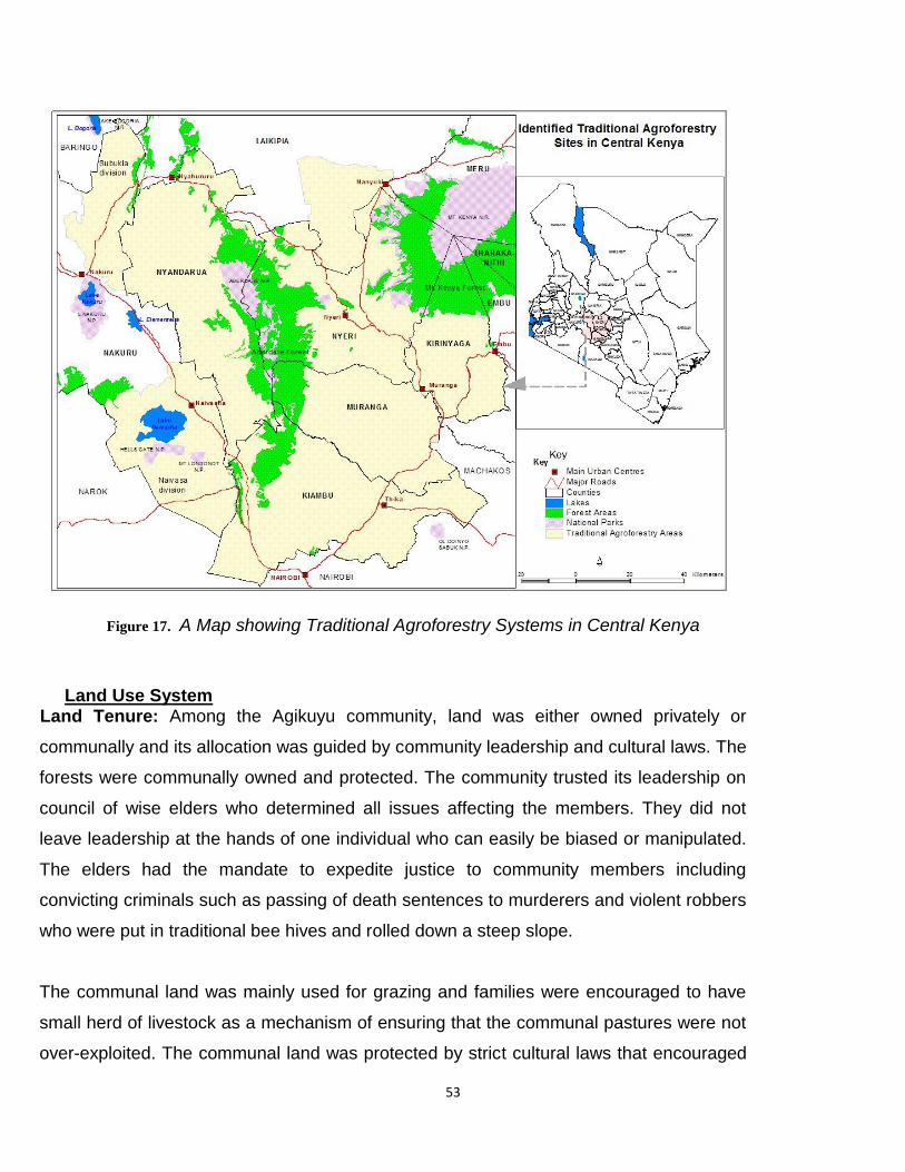
53
Figure 17. A Map showing Traditional Agroforestry Systems in Central Kenya
Land Use System
Land Tenure: Among the Agikuyu community, land was either owned privately or
communally and its allocation was guided by community leadership and cultural laws. The
forests were communally owned and protected. The community trusted its leadership on
council of wise elders who determined all issues affecting the members. They did not
leave leadership at the hands of one individual who can easily be biased or manipulated.
The elders had the mandate to expedite justice to community members including
convicting criminals such as passing of death sentences to murderers and violent robbers
who were put in traditional bee hives and rolled down a steep slope.
The communal land was mainly used for grazing and families were encouraged to have
small herd of livestock as a mechanism of ensuring that the communal pastures were not
over-exploited. The communal land was protected by strict cultural laws that encouraged
54
sustainable use of common resources. Prior consent from the elders was required to cut
down a tree and permission was granted to persons who had serious justification for the
need of tree products such as construction of a house. There were taboos that restricted
indiscriminate and unnecessary cutting of trees and especially felling of valuable tree
species like Mugumo tree. Commercial exploitation of natural resources such as forests
was strictly forbidden in realization that natural resources belonged to the community and
were not meant for exclusive use by an individual. This served as an inherent mechanism
for protecting and conserving the biodiversity and environment. It also helped in protecting
the common resources and circumvented the occurrences of the tragedy of the commons.
Practices and Management of Traditional Agroforestry Systems Traditionally, crops, livestock and trees were deliberately incorporated onto the same
piece of land since time Immemorial. The cropland is characterised by the upper layer
being dominated by tall trees, the middle layer by shrubs, bananas and fodder shrubs
while the ground layer is dominated by annual crops and grasses including maize, beans,
Napier grass, root crops, etc. The crop associations and rotations are carefully chosen,
arranged and monitored to reduce competition and to improve the total production. There
are several tree species planted or conserved on cropland and pastures such as Cordia
africana, Grevillea robusta, Commiphora zimmermannii and Trema orientalis. There are
several niches for planting trees including boundary, cropland, grazing land, home
compound, water courses, etc. The community has rich ethno-botanical knowledge about
trees and over 400 species have been named and their uses are well known after
centuries of experimentation and validation.
The resilience of traditional farming systems highly depended on diversification of crops
and livestock enterprises. The tradition agricultural systems have inherent mechanisms
for nutrient recycling and thus ensure sustainable land productivity through the
maintenance of soil fertility and vegetation cover. The crops are planted together with
trees scattered in the farm or arranged around the farm boundaries. Farmers produce
mixed crops such as cassava, millet, sorghum, yams, sweet potatoes, bananas, pumpkin,
arrowroots and early-maturing crop varieties such as composite maize and Irish potatoes.

55
The drought tolerant varieties include yams, cassava, sweet potatoes and Dolichos
lablab. Most of these crops are easy to store for long periods after harvesting. Other
crops are produced for both human and livestock feeds such as sweet potatoes, millet,
sorghum and bananas.
Traditional tool for cultivation is known as “Muro” and resembles the hoe. Livestock feeds
include planted fodder such as Napier grass, sweet potato vines, fodder shrubs and
herbaceous legumes and are also supplemented by crop residuals. Fodder trees and
shrubs are deliberately conserved on the farm in-situ to feed livestock when the need
arises and especially during the dry season. Cut-and-carry feeding system ensures that
fodder species and crops are protected from destruction by livestock. The community
usually keeps small herd of livestock including cattle, sheep, goats and poultry. The
diversification of farm enterprises and production of drought-tolerant crop varieties are
strategies to improve and stabilize the household food security and economy. The
survival of the community has for long depended on diversification of agricultural
enterprises and conservation of the environment through the use of appropriate farming
practices.
In the past, the traditional agroforestry systems involved shift cultivation practices where
an exhausted piece of land was left fallow and the farmer opened another piece of land
for cultivation. The land was left fallow to allow the regeneration of trees and rejuvenation
of exhausted soils. Controlled grazing was allowed on fallow land. Selected tree species
that have minimal negative effects on food crops in terms of competition for nutrients and
water were allowed to grow together with the crops. Examples are Cordia africana,
Dombeya goatzinii, Grevillea robusta and Commiphora zimmermannii. The presence of
trees in the farm makes it easier for the farmer to take home firewood and fodder after
cultivating the land. Thus, farmers and especially women are able to save on time and
efforts required to fetch these products from the wild. Research has proved that
agroforestry systems with crops, livestock and trees enable efficient recycling of soil
nutrients.

56
Traditional agroforestry system has been practiced by the community through generations
and the community migrate with this tradition into new areas. A case in point is Kieni
areas of Nyeri County that prior to settlement had Savannah type of vegetation but today
people are practicing agroforestry systems bringing tremendous changes to the
landscape. Despite the community’s propensity to embrace new technologies, it has not
abandoned several components of traditional agroforestry systems and instead they have
been incorporated into today’s farming practices. It is easy to distinguish the farms of the
Agikuyu community by the characteristic presence of trees scattered in the homestead
and cropland and a few animals in the farm. Common tree species on the farms include
Grevillea robusta (Silk Oak) and Croton megalocarpus planted around the farm
boundaries, Cordia africana, and Dombeya goatzinii scattered in the farm and Mugumo
(Fig) tree left undisturbed. Fruit trees such as avocado, mango, citrus, loquats and
macadamia are planted together with crops in warm areas while temperate fruits such as
plums, peaches and apples are planted in cool areas of Limuru in Kiambu County,
Kinangop and Kipipiri in Nyandarua County. Trees found in the cropland serve different
purpose such as provision of fuelwood, timber, fodder, fruits, herbal medicine, bee forage,
erosion control and other uses.

57
Figure 18 Intensive Multi-layer Traditional Agroforestry System at the slopes of Mount Kenya
3.3 Values and Benefits of Traditional Agroforestry Systems
Broadly, the values and benefits of traditional agroforestry systems can be categorized
into household food security and incomes, environmental, social and cultural terms.
These values and benefits have significant contribution towards the sustenance of
people’s livelihoods and the environmental resilience as highlighted below:
Household food security and incomes Food security refers to a situation where people have access to sufficient food that meets
their nutritional requirements at all times of the year (Kenya Government, 2011). The
traditional agroforestry systems have inherent mechanisms that ensure people have
adequate food at different times of the year from diverse products and benefits that
include food crops, fruit trees, vegetables and livestock products. This enhances
58
household food security, stabilize the incomes and cushion the families against
production and market risks. The multiple products and benefits also increase the
household income base, provide better returns to investment, improve the household
nutrition and ensure food availability throughout the year. The overall benefit from an
agroforestry system is improving the livelihoods of the people, reducing poverty levels
and sustaining the system ecological stability. The system also provides safety measures
for coping with drought incidences in situation where the system has drought tolerant crop
varieties such as millet, sorghum, cassava, yams and Dolicos lablab. The post-harvest
loses is reduced by constructing storage facilities using pest-repellent materials.
Traditionally, fodder and medicinal trees and shrubs are usually conserved in-situ by
allowing them to grow on the farm undisturbed and are only harvested in times of need.
Despite the fact that most traditional crops are drought tolerant and do not require hybrid
seeds, their yields are low discouraging commercial seed companies to develop interest
in their production. The research and extension services have a role to promote
production and consumption of traditional crops up to the point when demand will justify
the interest and participation of the private sector. The government through KARI and
KEPHIS has to ensure that the genetic value and purity of released parental lines are
sustained by supervising and educating the enlisted institutions and farmer groups
charged with the responsibility of bulking, multiplication and distribution of certified
planting materials.
Over 10 million Kenyans suffer from poor nutrition and chronic food insecurity and
estimated 30% of Kenyan children are undernourished (Kenya Government, 2011). The
government estimated that 2-4 million people are in constant need of emergency food
assistance. The right to quality food is guaranteed in the Kenyan Constitution under the
section of Economic and Social Rights (The Constitution of Kenya, 2010). The
government has the duty and obligation to accord the Universal human rights to its
citizens by ensuring that every person has access to quality and affordable food at all
times of the year. The options to achieve this goal include diversification of food
production, proper storage and efficient food distribution in the country. A lot of food is

59
wasted every year from unhygienic handling and poor storage leading to contamination of
food by pathogens such as aflatoxins and salmonella. Loss and wastage of food must be
avoided and the government need to improve the strategic food reserves to cater for
emergencies. This calls for development, enactment and enforcement of safety standards
and guidelines for food handling and storage to make it safe for human consumption.
Occasional loss of live and diseases resulting from food contamination has been reported
in some parts of the country.
Some parts of central Kenya experience frequent and prolonged droughts making them to
have high levels of food deficit and poverty. These include Kieni in Nyeri County, Ndeiya
in Kiambu, Mwea in Kirinyaga, Ndaragwa in Nyandarua and Makuyu in Muranga. There is
need for the government and development agencies to invest in research and promotion
of drought-tolerant crop varieties with the aim of improving food security status and the
livelihoods of the people.
Cultural and social values The survival of the people has mainly depended on inherent knowledge of proper and
efficient management of the ecosystem using the indigeneous knowledge. Dissemination
of knowledge and skills on management of the ecosystem mainly depended on farmer-to-
farmer mode of technology transfer. Indigenous knowledge and taboos had traditionally
assisted in conservation of natural resources including rare tree species as well as in
sustaining land productivity. For a long time, the local people have been aware that trees
contribute tremendously towards the environmental services including the supply of clean
air, water and medicine. The presence of multiple products in an agroforestry system
ensures that the farmer saves on time and efforts required to fetch firewood, fodder and
herbal medicine from the wild. It ensures sustainable exploitation of the biodiversity
including herbal medicine, fodder, fruits, bee forage, fuelwood and construction materials.
The traditional systems are embedded in community’s way of life making it easy to
naturally pass the practices from one generation to another.

60
3.3.3 Environmental services
As part of the public goods, agroforestry systems have continuously provided
environmental services such as contribution towards climate change adaptation and
mitigation through carbon sequestration, watershed protection and conservation of the
biodiversity. At private level, agroforestry benefit farmers through provision of products
such as fruits, fodder, firewood, medicine and services such as improvement of soil
fertility and reduction of soil erosion. It is easy for the farmers to perceive these benefits
making it an impetus for adoption and expansion of agroforestry practices. However,
external interventions may be necessary especially in provision of planting materials and
managerial skills to catalyze the adoption process. The traditional agroforestry systems
enhance environmental and biodiversity conservation, contribute towards ecosystem
resilience and enhance ecological services including soil erosion control and increased
water infiltration. The wood perennials assist in climate change adaptation and mitigation
through carbon sequestration.
3.4 Contribution of Traditional Agroforestry Systems in Climate Change Adaptation and Mitigation
Climate change refers to the differences in the average weather condition for a certain
period that may range from months to tens, thousands or millions of years (University of
Philippines, 2009). The climate change has become a major concern in the agricultural
sector due to its impacts on altering the cropping seasons and increased incidences of
pests and diseases. This has direct effects on agricultural productivity and food security at
local and global levels. Farmers have been forced to find mechanisms for coping and
adapting to the challenges posed by the climate change. Evidence for climate change
include increased average temperatures associated with increased emission of green
house gasses, extreme climate variability, rise in sea level and increased frequency and
intensity of typhoons. This has impacts on food availability and supply, increased
incidences of pests and diseases and loss of living things that are unable to cope with
changes in temperatures and humidity.

61
The tradition agroforestry practices encourage preservation of trees and other perennials;
thus contribute towards absorption of green house gases like carbon dioxide. The
systems are quite effective in preservation and conservation of biodiversity, reduction of
soil erosion and improvement of soil fertility. Indigenous tree species along the water
courses are usually conserved and this helps in increasing rain water infiltration, reduction
of soil erosion, control of floods and protection of water channels by the tree root systems.
Litter fall from layers of vegetation increase soil organic matter while leguminous species
fix and add nitrogen to the soil. The deep root systems of trees help in nutrient recycling
by extracting leached nutrients and bring them back to the soil surface through the litter
fall. Most of the indigenous tree species in traditional agroforestry systems are deep
rooted posing little competition to food crops.
3.5 The Value and Role of Some Indigenous Tree Species The community highly value trees for meeting numerous needs including the provision of
fuelwood, construction materials, fodder, fruits and herbal medicine. Trees are also
valued for their environmental services such as soil erosion control and fertility
improvement. The community has rich ethno-botanical knowledge about trees and it is
documented that over 400 tree species have been named and their uses are well known.
Several tree species are deliberately conserved or planted together with crops e.g. Cordia
africana, Grevillea robusta, Commiphora zimmermannii and Trema orientalis. However,
valuable knowledge and skills of tree propagation and utilization especially the indigenous
species that have medicinal value have not been properly documented and archived for
future use. The selective custodian and passage of this rare and vital knowledge has
relied on word of mouth and it is likely that most of it may have been lost with the death of
individuals who possessed it.
Mugumo or Fig tree (Ficus thonningii and Ficus natalensis) is a sacred tree with important
religious value including traditional rituals and worship. There is an existing museum site
with a huge Fig tree at Mukurwe-wa-Nyagathanga in Murang’a County where the
community believes their first ancestral father Gikuyu and his wife Mumbi were sent to live
by God (Gachathi, 1989). Many tree species provide herbal medicine for treatment of

62
various human and livestock diseases. The medicine is extracted without destroying the
trees. These include Prunus africana (Muiri), Warbugia ugandensis (Muthiga), Croton
macrostachyus (Mukinduri), Olea europaea (Mutamaiyu), Carisa edulis (Mukawa),
Strychnos henningsii (Muteta) and Myrsine africana (Mugaita). Kigelia africana (Muratina)
was used for fermentation of traditional honey and sugarcane beer. Fruit trees included
Vangueria madagascarensis (Mubiru), Carissa edulis (Mukawa), Rhus natalensis
(Muthigiu), Syzygium guineense (Mukoe) and Psidium guajava (guava).
Indigenous species that are important in feeding livestock include Trema orientalis
(Muhethu) and Sesbania sesban (Mwethia) but exotic species have also been adopted
widely such as calliandra, leucaena and tagasaste (Wambugu, et.al, 2011). The fodder
species are usually conserved in the cropland where the farmers use the “cut-and-curry”
harvesting practices. Crinum macowanii (pyjama Lily or Gitoka), Euphorbia tirucalli (finger
euphorbia) and Croton megalocarpus (Mukinduri) are used as boundary markers.
Syzygium guineense (Mukoe), Prunus africana (Muiri), Bridelia micrantha (Mukoigo) and
Dombeya goatzennii (Mukeu) are usually conserved along water courses.
3.6 Distraction of Traditional Agroforestry Systems The disruption of traditional agricultural system was mainly caused by historical events
such as colonization, population dynamics and enactment of conflicting land use policies
and laws. The disruptions of these traditional systems had adverse effects on people’s
livelihoods, the resource base and the environment resulting to food insecurity,
environmental degradation, ecological disturbances, economic decline and changes in
the landscapes from loss of vegetation cover. Ultimately the effects were felt through
increased soil erosion, decline in soil fertility, loss of biodiversity, decline in water levels
including changes in river flows and the disappearance of some of the rivers and streams.
These effects had also drastic impacts on food production. Some of the historical events
and changes in land use policies and laws are highlighted below.
Kenya was declared a protectorate of the British government in 1895 and a colony in
1920. The colonial government passed the Crown Land Ordinance no. 21 of 1902 that

63
gave the land commissioner powers to sell and distribute land to white settlers at the
expense of the local communities. By 1914 over 5 Million acres of land had been taken
away from the Africans (mostly the Maasai, Kikuyu and Nandi) and transferred to the
white settlers. In 1910, the colonial administration introduced the “Shamba system” that
has been practiced in Kenya for the last century as highlighted in a separate section
below. The Registration of Title Ordinance of 1919 was introduced to supersede all
previous land laws throughout the country. The ordinance legalized privatization of land
ownership through issuance of land title deeds to the white settlers. This led to forceful
acquisition and re-allocation of land to the white settlers by the colonial government. The
white settlers put the land under mono-cropping of cash crops such as tea, coffee, sisal
and pineapples. Some of the land was put under pastures for cattle and wool sheep. The
impact of wide scale change of land use by colonial settlers was evident on the
landscapes that lost most of the indigenous vegetation and the disruption of the traditional
agroforestry systems.
Introduction of mono crop plantation systems
The locals were forced to resettle in restricted colonial villages (reserves) allowing
them to cultivate scattered pieces of land. This disrupted the traditional agricultural
systems and reduced the overall agricultural production by the local community. Some
of the land was put under communal use but it was too little to meet their needs
leading to its over-exploitation and subsequent degradation from overgrazing and
continuous cultivation without addition of manure and fertilizers. The limited land
availability resulted to unrestricted use of common resources such as the pastures
because any person could freely increase the exploitation of the common resources to
the point of its unsustainable utilization leading to the “tragedy of the commons”.
Prior to independence, in 1954 the colonial government set up the Swynnerton
Commission that addressed land reforms in African reserves. It enacted a policy for
land amalgamation and consolidation targeting the land under local communities.
However, the land under colonial settlers was left intact and the land under the local
community was too little to revert back to traditional agroforestry systems and also
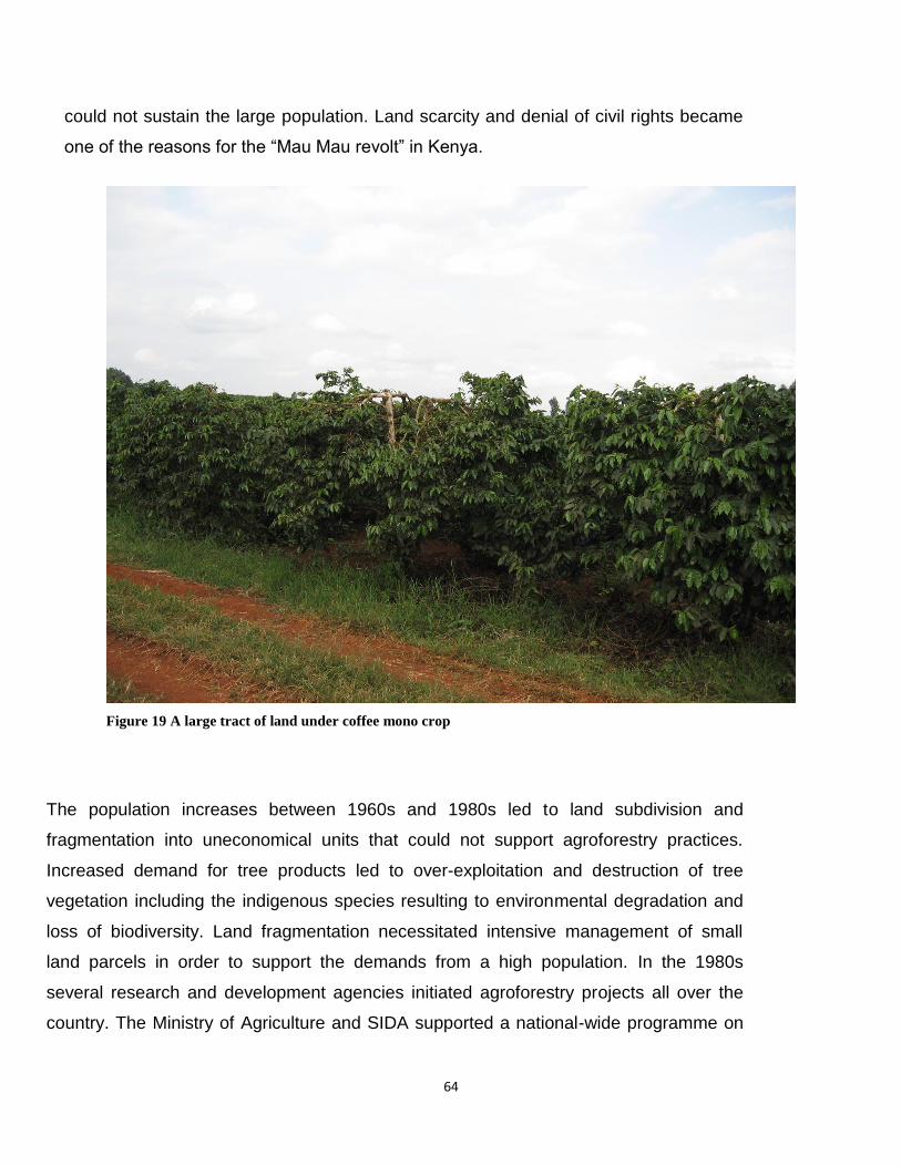
64
could not sustain the large population. Land scarcity and denial of civil rights became
one of the reasons for the “Mau Mau revolt” in Kenya.
Figure 19 A large tract of land under coffee mono crop
The population increases between 1960s and 1980s led to land subdivision and
fragmentation into uneconomical units that could not support agroforestry practices.
Increased demand for tree products led to over-exploitation and destruction of tree
vegetation including the indigenous species resulting to environmental degradation and
loss of biodiversity. Land fragmentation necessitated intensive management of small
land parcels in order to support the demands from a high population. In the 1980s
several research and development agencies initiated agroforestry projects all over the
country. The Ministry of Agriculture and SIDA supported a national-wide programme on

65
soil and water conservation that included the promotion of agroforestry practices. It is
under this project that a lot of awareness was raised on potential benefits that can be
accrued from agroforestry practices. Currently, many agricultural projects in the country
have agroforestry components and thus it is easy to incorporate traditional practices that
enhance agricultural productivity and sustainability.
The “Shamba System” The “Shamba system” was introduced in 1910 by the colonial government in some of the
state-owned forests including Mount Kenya and Aberdare Forests in central Kenya
region. It is a modified form of Taungya system that is practiced in South East Asia and
involves establishment of forest plantations together with food crops. The main objective
of the system was to benefit the landless by giving them opportunity to produce food in
government forests and in return benefit the government by taking care of tree seedlings
growing together with the food crops. The farmers tend the young trees for 2-3 years
when the tree canopies close in and can no longer allow continued growth of crops. The
farmers then shift to another site where the government intend to expand the afforestation
programme. More or less the “Shamba system” is a form of silviculture shift cultivation.
Initially, resident forest workers were allocated freshly cleared forest areas to plant food
crops followed by tree planting. This system enabled the government to establish forest
plantations at minimal costs, ease pressure on natural forests and allow farmers to
produce food crops on government land. The government aimed at meeting the increased
wood demand for industrial and domestic use. A lot of revenue was generated from the
sale of wood and non-wood products from the “Shamba system” when the system was
working well. Some of the forests where the “Shamba system” was practised include
Kereita and Kinale (Aberdare Forest) in Kiambu County, Kabage and Zaina (Aberdare
Forest), Gathiuru and Kabaru (Mount Kenya Forest) in Nyeri County and Njukini West
(Mount Kenya Forest) in Kirinyaga County.
From 1910 to 1975, the “Shamba system” resident workers employed by the Forest
Department were allocated forest plots (shambas) and guaranteed employment for nine

66
months per year. The produce from the shambas was considered to be part of the
workers´ emolument (Kagombe and Gitonga, 2005) and compensated them for the
remaining three months of unpaid salaries. The system was revised in 1975 and the
resident workers were fully employed for twelve months of the year but they were now
required to rent the shambas. The system also opened doors to non-forest workers
leading to increased number of people who were benefitting from forest resources. This
made the supervision problematic as newcomers did not understand how the system
operated resulting to low survival rates of tree seedlings. The system was consequently
banned by a presidential decree in 1987, and in 1988 all the forest residents were evicted
(Kagombe and Gitonga, 2005). Unfortunately, prior to the banning decree, the
government had not put in place alternative systems of establishing and managing forest
plantations resulting to stagnation of reforestation programmes in the country. Less than
20% of clear-felled areas were replanted and about 80% of replanted areas were not
weeded (Kagombe and Gitonga, 2005). The situation was aggravated in 1994 by civil
service retrenchment programme, leading to an acute shortage of labour in forest
stations. This led to decline in tree production and acute shortage of wood products
forcing the country to import wood products from other countries such as Uganda and
Democratic Republic of Congo (DRC).
In 1994, the government reintroduced the non-resident cultivation “Shamba system” in
some districts under the management of District Development Committees (DDC). By
1997, the government expanded the programme to all major forests in the country. This
involved policy changes shifting the management of the “Shamba system” to the District
Development Committees (DDCs) that were dominated by politicians and provincial
administration. The input from the technical personnel was often ignored resulting to
indiscriminate clearing of areas that are unsuitable for cultivation such as the natural
forests and river banks. The stakeholders were not adequately involved in decision
making processes. The end result was failure to establish new plantations and in some
cases destruction of natural forests leading to the banning of the “Shamba system” in
1986.
67
The acute shortage of raw materials for expanding the timber industry and pressures on
the natural forests led the government to reinstate the “Shamba system” in 1994. It was
re-designed into a non residential cultivation system. Unfortunately, the new system failed
to deliver as expected leading to its banning in 2003. The banning of the system in
addition to excision of forests for alternative land uses, including human settlement and
expansion of agricultural activities reduced the forest plantations from 160,000 hectares in
1994 to 40,000 hectares by 1999 (Kagombe and Gitonga, 2005). The situation was
worsened by unsustainable harvesting of trees, low replanting rates, shortage of labour,
low levels of funding and extensive damage of forest plantations by fires, especially in the
period between 1992 and 1999. In 1992, fire destroyed 6,170 ha of plantations; in 1997, a
further 4,726 hectares were burned (Kagombe and Gitonga, 2005).
Some of the honey collectors carelessly started forest fires that ended up destroying the
forests leading to substantial loss of biodiversity and destruction of the ecosystem. Abuse
of the system by greedy people led to illegal and indiscriminate logging of indigenous tree
species leading to loss of biodiversity and environmental degradation. Valuable timber
trees including Ocotea usambarensis (Camphor), Vitex keniensis (Meru Oak) and Prunus
africana (Red Stinkwood) now face extinction as a result of illegal and indiscriminate
logging.The Forest Department increased the plantation hectarage in absence of the
“Shamba system” but the results were quite shocking. The seedlings survival rates
declined from 90% to 10% in some of the plantations due to lack of weeding (Kagombe
and Gitonga, 2005).
Since the late 1980s, KEFRI conducted extensive investigations on alternative methods
of establishing and managing forest plantations, including natural regeneration, slashing,
spot-hoeing, slashing and total cultivation. Data generated from studies conducted at
Uplands Forest Station in Kiambu County on costs of forest plantation establishment and
management are as follows: The cost of plantation establishment per hectare for the first
3 years was as low as Ksh 6,000 for non cultivated sites and as high as Ksh 44,500 for
total cultivation. The slashing costed Ksh 20,000 and slashing and spot-hoeing costed
Ksh 25,000 (Kagombe and Gitonga, 2005). A plantation is considered to be well
68
established after the third year, when the canopy closes in. Under the “Shamba system”
most of the costs are borne by the farmer including site clearing, staking, planting and
tending tree seedlings for a period of about three years. The system contributes towards
higher tree survival rates, better protection from animal damage and reduced
susceptibility to pests and diseases. In return, the farmer benefits from food production on
government land. Total cultivation, though expensive, is the most appropriate method for
forest plantation but in absence of adequate resources, the non-residential cultivation is
the most viable method. If well-managed the “Shamba system has similar results to the
total cultivation with the advantage of sharing the costs and benefits between the
community and the Forest Department.
The “Shamba system” has many benefits to the local community in terms of employment
creation, cash economy from sale of crops such as vegetables and Irish potatoes to major
towns. It can suport the livelihoods of large population of landless people and those in the
food value chain in terms of food provision and incomes. A study conducted in 1998 in
Kiambu indicated that on average the net benefit to a farmer practicing “Shamba system”
was Ksh 124,141 per hectare per year but benefits may vary from place to place
depending on productivity, access to markets and crop management (Kagombe and
Gitonga, 2005).
The banning of the “Shamba system” had drastic impacts on food security and the
economy of the people residing in the central region of Kenya. The “Shamba system” of
non resident cultivation remains the most viable option under the current funding scenario
with improvements on its implementation strategies and approaches including: formation
of inter-institutional supervisory committee with full involvement of the beneficiaries to
monitor and guide its performance, zone and map areas appropriate for the reintroduction
of the system to avoid opening up sensitive areas such as the riverbanks and indigenous
forests, provide clear guidelines and regulations that should be strictly enforced to deter
any abuse. There is need to work out modalities that allow participatory formulation of
procedures for forest establishmant and management that ensure equitable sharing of
costs and benefits between the farmers and the government. The lessons of past

69
performance need to be incorporated so as to improve the implementation of the “
Shamba system” in the country. Due to its benefits, many people today indicate that they
would prefer the system to be reintroduced but with more strict rules that govern its
operations to ensure sustainable exploitation of the forest resources. A well managed and
supervised system has the potential to benefit the government, the farmers and other
people who depend on forests for commercial extraction of wood and non-wood
resources. There is need to institute mechanisms that ensure sustainable exploitation of
forest resources, guarantees expansion of forest cover and conservation of both flora
(plants) and fauna (animals). The communities that reside in the neighbourhood of the
forests need to be sensitized and educated on the need to conserve and protect the
forests and other natural resources. Appropriate policies and laws need to be enacted
and strictly enforced to ensure effective and efficient conservation of natural resources.
Grazing of Livestock in State-owned Forests Like in the case of the “Shamba system”, the government allowed farmers to graze their
livestock in the forests but at a small fee. Only cattle and sheep were allowed to be
grazed. Goats were strictly prohibited from grazing in the forest due to their destructive
nature. The system is still being practised in some of the government forests. Pastoral
communities like the Maasai and Samburu are allowed to take their livestock to state
forests during severe droughts to reduce livestock and human mortalities. Unfortunately,
in the past heavy losses of livestock has been witnessed as a result of diseases and
pests prevalent in high altitude areas. On the other hand, communities living near the
forests also lose their livestock from pests and diseases transmitted by livestock
belonging to pastoral communities. Livestock grazed in the forest also get affected by
pests and diseases from wild animals including the tick-borne diseases.
3.7 The Current Trends in Promotion of Agroforestry Practices The current agroforestry practices in central Kenya have borrowed many elements of the
traditional agricultural systems. It could be a modification of an existing practice such as

70
managing different tree species and crop varieties but managed in a familiar way.
However, others are managed in a totally new way such as the improved fallows which is
a completely new way of farming in most areas (Place, et.al, 2012). The FAO Forest
Resources Assessment Report indicates that the total tree cover in Kenya outside the
forests (mainly in agroforestry systems and trees in urban areas) is greater than tree
cover within the forests. In addition the forest cover in Africa continues to decrease while
the tree cover on the farms is increasing (FAO, 2003). The trend is likely to continue
because of increased demand for tree products and services as human population
increases. The importance of smallholder agroforestry systems is likely to be reinforced
with increased attention and resources allocation to climate change adaptation and
mitigation whereby more efforts are being made to protect forests and simultaneously
expanding tree growing on farms (Place, et.al, 2012).
In the 1990s, various research and development agencies including SIDA, GTZ, KWAP
and FAO, teamed up with government agencies to promote agroforestry practices.
Agroforestry projects were initiated in several parts of the country and mainly focused on
fast growing exotic tree species such as Grevillea, Leucaena, Calliandra and Casuarina.
There was very little that was done to restore the indigenous tree species in the farmlands
possibly because these species take a long time to mature. The Ministry of Agriculture in
collaboration with SIDA had a nation-wide programme known as the “Catchment
Approach” that focused on integrated farm management approach through soil and water
conservation, fodder and fruit production. The programme aimed at increasing agricultural
productivity and ecosystem conservation through reduction of soil erosion on sloppy
areas and protection of water catchments in the country. This initiative yielded dividend
since lots of awareness was created, lots of sloppy land was terraced and agroforestry
trees were planted in the farms contributing to wide-scale changes on the landscapes.
Some of the research and development organizations focused on agroforestry systems
that are geared towards production of specific commodities. ICRAF, KARI and KEFRI
researched and promoted agroforestry systems that focused on soil fertility
improvements, fruits and dairy production. ICIPE focused on agroforestry systems that

71
deal with bee production (apiary) and silk worm production (sericulture). GEF, KEFRI,
Green Belt Movement and KFS, promoted agroforestry systems that aimed at protecting
and conserving Mount Kenya and Aberdare forests. The communities that live adjacent to
these forests illegally rely on wood and non-wood products from state-owned forests and
therefore are major contributors to the destruction of the forests. They need to be
sensitised and educated on the need to incorporate agroforestry practices in their own
farms to reduce the pressure they exert on forests. Currently, there are a number of
national and international institutions such as KARI, KEFRI, KFS, Green Belt Movement,
ICRAF and GEF that have agroforestry-based projects around the Aberdare and Mount
Kenya forests. The projects include silviculture (trees with crops), silvo-pastoral (trees
with pastures and livestock), apiculture (trees for honey production) sericulture (trees for
silkworm production) and aquaculture (trees with fish). These projects aim at the
restoration of the forest ecosystem. There is need to integrate other conservation
measures such as the increased use of renewable energies like solar, wind and hydro
energies to replace the use of wood energy. Production of charcoal and use of firewood
has been quite detrimental to the environment and is associated with climate change as a
result of emission of green house gases such as carbon dioxide. Tree species that
produce high quality charcoal such as Olea and acacia face extinction due to over-
exploitation.
Organizations that are promoting agroforestry practices often encourage incorporation of
trees and shrubs into the farm as live fences, boundary markers, windbreaks, hedges for
soil erosion control, fodder banks, wood lots, etc. Increased planting of trees and shrubs
on the farms help in conservation and protection of natural forests as wood products and
services can be obtained from the farms and thus reduce the pressures on exploitation of
forest resources (Wambugu and Franzel, 2012). There is scientific evidence that some of
the tree species can directly help in increasing land productivity and mitigate on climate
change. Fodder shrubs can effectively replace some of the concentrates and part of the
basal diet of dairy livestock leading to increased milk production per cow (Franzel and
Wambugu, 2007). This may necessitate the reduction of the number of cattle in the farm
and subsequently reduce the amount of methane emission at an individual farm

72
(Thornton & Herrero, 2010). In case of fodder production, only the leaves are harvested
leaving behind the woody stems above the ground and the root systems below the
ground and thus an immense contribution towards carbon sequestration (Wambugu and
Franzel, 2012).
3.8 Challenges in Traditional Agroforestry Practices The forest cover in Kenya is only 3% which is below the global recommendation of at
least 10% of the total land in a country. The forest cover has been disappearing over
time and on the contrary, the agroforestry practices outside state-owned forests have
been on the increase. The farming community lack access to adequate and quality tree
germplasm especially in the case of indigenous species. Many farmers do not have the
knowledge and skills in germination and management of agroforestry tree species and
traditional crop varieties that are better adapted to the local agro-ecological environment.
The investment by the government and NGOs in germplasm multiplication and
distribution is quite low and thus limiting the expansion of agroforestry practices. There is
also need to invest in building the farmers’ technical capacity in seed technology
including seed collection, storage and propagation methods.
Involvement of the private sector has been hindered by free and subsidized germplasm
supply by the government and NGOs and thus denying the private sector opportunity to
invest in seed supply business ventures (Wambugu, et.al, 2011). Tree seed may be
required only once in a person’s lifetime making the demand to be quite low unlike the
annual crops that a farmer has to buy every season (Place, et.al, 2012). This
discourages the private entrepreneurs to venture into tree seed business. Seedlings
distribution is hampered by the fact that they are delicate and bulky, thus limiting the
distance and time period they can be transported. It is difficult to differentiate the quality
of tree germplasm casually and this hampers the ability of suppliers to charge prices that
commensurate with the quality of germplasm (Place, et.al, 2012).

73
The population increases in 1960s to 1980s led to over-exploitation and subsequent
degradation of natural resources such as land, forests and water. It necessitated the
expansion of agricultural land to forested and sloppy areas resulting to land degradation
from soil erosion, deforestation and loss of biodiversity. Further increase in population led
to continued land sub-division and fragmentation into uneconomical units that cannot
support agroforestry practices. The population increase has led to the intensification of
agricultural production in order to meet increased food demand.
Permanent cropping and lack of resources for replenishing soil nutrients is leading to
serious soil degradation and exhaustion particularly in the smallholder farming areas
(Place, et.al, 2012). Subsequently, the infertile soils lead to low yields and ultimately food
insecurity. The eroded soils are deposited in water courses leading to the siltation of lakes
and dams in the country. There is evidence that the siltation of Lake Naivasha and L.
Olbolossat, Sasumua and Kindaruma dams are the consequences of deforestation and
cultivation of the Aberdare slopes. The expansion cultivation land has not spared the
wetlands either leading to loss of bio-diversity. As a result of human activities in forests
and wetlands, important flora and fauna that have high environmental, economic and
social values now face extinction. The impacts of climate change are unreliable and
erratic rainfall, prolonged droughts and occurrence of floods which have adverse effects
on agroforestry practices. It is no longer possible to predict the rains in the area unlike
before when farmers could correctly predict the time for rain onset in preparation for a
planting season. The impacts of climate change have presented big challenge to the
agricultural production and food security in the area.
High potential agricultural land neighbouring urban areas are being converted into
settlement sites leading to significant reduction in land under agricultural production. The
trend of urbanization (settlement) of previously high potential agricultural lands has
resulted to loss of land for production of crops, trees and livestock. High rise buildings
have virtually replaced vegetation especially coffee plantations and forest cover in all
areas neighbouring Nairobi Metropolitan. This trend should not be allowed to continue as
it is threatening the survival of the people. Instead large population should be

74
encouraged to settle in towns leaving agricultural land to few capable farmers to
efficiently produce adequate food to support the urban population. This requires a
refocus on the national land policy and laws so as to facilitate effective agricultural
production by reducing land fragmentation, urbanization of agricultural lands and
encroachment of forests. This demonstrates that there are a number of important policy
constraints that hinder wider adoption of agroforestry systems among the smallholder
farmers in developing countries, both at formulation and implementation levels (Place,
et.al, 2012). Enactment of laws and policies that recognize agroforestry as an attractive
investment in the agricultural sector is likely to lead to increased adoption of agroforestry
practices in the country.
3.9 Opportunities in Traditional Agroforestry Systems Most of the agricultural land in Kenya is under private ownership which is an incentive
that encourages tree planting and management. In absence of secure land tenure, tree
planting and management by farmers has been limited. The state has to work towards
achieving and maintaining a tree cover of at least 10% of the land area of Kenya (The
Constitution of Kenya, 21010). The agricultural policy reforms of 2009 that is anchored in
Vision 2030 of the Kenya Government require that 10% of all farms be under tree cover
as a solution for dealing with the effects of deforestation. The policy is likely to lead to
increased agroforestry practices and subsequent huge demand for tree planting
materials. The stakeholders in government and development agencies need to develop
mechanisms for the supply of tree germplasm including the indigenous species.
There has been increased global attention on climate change adaptation and mitigation
that has led to availability of more resources for advancement of agroforestry practices.
This is in recognition of the role traditional agroforestry systems played in sustaining
agricultural production and resilience to climate change and variability. The systems have
higher efficiency in the use of resources and inputs for production as they contribute
towards nutrient recycling processes. FAO is leading an initiative to develop agroforestry
guidelines for policy makers, aiming at promotion of good agroforestry practices. FAO is
also supporting the development of a framework for assessment of trees outside forests,

75
including agroforestry systems, at national, regional, eco-regional and global levels
(Place, et.al, 2012). This will be a key element in policy reforms to enable informed
decision-making processes. There is greater policy recognition of the importance of
agroforestry in the country and possibly address the policy barriers that have in the past
hindered the recognition of agroforestry development.
Increased demand for forest products and the closure of state-owned forests makes
agroforestry an attractive option for the communities that previously relied on government
forests. Research has proven that agroforestry is a viable option for restoration of
degraded lands and thus an incentive for its adoption. Linkages and collaboration among
research and development agencies need to be established and strengthened for the
advancement of agroforestry practices. This calls for public and private partnerships in
addressing the challenges of advancing agroforestry development.
The practices of “climate smart agriculture” seems to have borrowed many of its elements
from the traditional agroforestry practices such as the conservation agriculture, better
management of manure and incorporation of perennials on smallholder farms. The
impacts of population increase on the environment calls for increased adoption of
agroforestry practices and conservation of the biodiversity so as to arrest the worsening
situation caused by the climate change. Policies should be enacted to protect and
increase the land under tree cover as well as conserving the wetlands. Farmers should be
encouraged to plant trees on sloppy areas that are unfit for agricultural production and the
wetlands should be protected by fencing them off. The state machinery should institute
mechanisms for compensating farmers who convert private land that is unfit for food
production into forest land. Research and development institutions should research and
promote appropriate crop varieties and tree species that are well adapted to specific agro-
ecological zones so as to optimize on land productivity. These institutions should develop
strategies of availing planting materials of traditional crops and indigenous tree species.
Since environmental conservation is by essence part of public goods, the international
community need to develop effective systems of rewarding individuals and organizations

76
that participate in ecosystem services such as tree planting, wetland conservation and
promotion of biodiversity.
4. Conclusions and Recommendations The traditional and heritage agroforestry systems need to be properly identified and
documented. The 2003 UNESCO convention tools can be adapted to help in
identification, validation, and valuation of traditional agricultural systems. The traditional
systems can effectively complement the modern agricultural production systems. Specific
studies are required to provide evidence of the contribution of traditional agricultural
systems to the national economy and development. The studies should also establish the
untapped potential values and importance of traditional systems including the contribution
towards food security and environmental conservation. Projects and programmes need to
be developed so as to facilitate dynamic conservation of traditional agricultural systems
and develop frameworks for rewarding the maintenance of their values similar to the
payments for ecosystem services.
The traditional agroforestry systems together with the rich indigenous ecological and
management knowledge can provide solutions to many agricultural challenges that we
face today including food insecurity and the impacts of climate change. Therefore, these
systems should be promoted to tap the rich indigenous knowledge and skills that were
used in balancing and sustaining agricultural production and environmental conservation.
Since agroforestry generates significant public environmental services such as watershed
protection, biodiversity, and carbon sequestration there is need for the government to
provide incentives to the private sector to get involved in promotion of agroforestry
practices.
Recognition of the values and importance of heritage agricultural systems including
traditional agroforestry systems by the FAO as well as contribution of the GIAHS – East
Africa project to the understanding of GIAHS concept and generation of knowledge on
existing systems is highly commendable. Furthermore inputs and contributions from the
GIAHS project national policy workshops held on 3-4th December 2012 and 6-7th
77
December 2012 in Nairobi and Dar es Salaam, respectively, provide a good basis for
further development of this initiative nationally and at global level.
5. Bibliography
AFRENA Report No. 16, Nairobi: Agroforestry Research Network for Africa, International Centre for Research in Agroforestry.
Allan, W. 1965. The African Husbandman. Oliver & Boyd, Edinburgh. ASAL-Applied Research Unit and Kenya Forestry Research Institute, 1999: Useful
Indigenous Plants of Mukugondo Division, Laikipia District (edited by Robinson Ngethe, Ben Chikamai, Norman Gachathi and Sheila Mbiru (Kenya Literature Bureau, Nairobi)
Bekele-Tessema, A. 2007. Profitable agroforestry innovations for Eastern Africa.
RELMA World Agroforestry Centre. Nairobi. Pp.277-286. Boko, M., I. Niang, A. Nyong, C. Vogel, A. Githeko, M. Medany, B. Osman-Elasha, R.
Tabo and P. Yanda, 2007: Africa. Climate Change. 2007: Impacts, Adaptation and Vulnerability. Contribution of Working Group II to the Fourth Assessment Report of the Intergovernmental Panel on Climate Change, M.L. Parry, O.F. Canziani, J.P. Palutikof, P.J. van der Linden and C.E. Hanson, Eds., Cambridge University Press, Cambridge UK, 433-467
FAO, 2003: Forestry outlook study for Africa: regional report for opportunities and
challenges towards 2020. FAO Forestry Paper 141. FAO, Rome. FAO, 2010: The Hague Conference on Agriculture, Food Security and Climate Change:
Climate-Smart” Agriculture Policies, Practices and Financing for Food Security, Adaptation and Mitigation.
Fernandez, E.C.M., O’Kiting’ati, A. and Maghembe, J. 1984. The Chagga home gardens:
a multistoried Agroforestry cropping system on Mt. Kilimanjaro (Northern Tanzania). Agroforestry System 2 73 – 86
Franzel S. & C. Wambugu. 2007. The uptake of fodder shrubs among smallholders in
East Africa: key elements that facilitate widespread adoption. In: Hare MD, Wongpichet K, eds. Forages: a pathway to prosperity for smallholder farmers. Proceedings of an international symposium. Ubon Ratchathani University, Thailand: Faculty of Agriculture. p. 203–222.
Franzel, S., Wambugu, C. and Place, F., (2011) Effective extension approaches for
natural resource management practices. The uptake of fodder shrubs in East Africa.

78
Paper presented at the University of Leeds Conference on Food Security, June, 2011.
Gachathi F.N., 1989: Kikuyu Botanical Dictionary of Plant Names and Uses (Nairobi,
Kenya) Graudal, L. and Lillesø, J, 2007: Experiences and Future Prospects for Tree Seed Supply
in Agricultural Development Support – Based on Lessons Learnt in Danida Supported Programmes 1965- 2005, Ministry of Foreign Affairs of Denmark.
HASHI, 2002. Ngitili 1930-2002. HASHI Record of Ngitili in Shinyanga Region from 1930
to 2002. (Unpublished Report). 105pp. HASHI-ICRAF 1997. HASHI-ICRAF Agroforestry Research Project, Shinyanga, Tanzania:
1997 annual report. HASHI-ICRAF Shinyanga, Tanzania.61 pp. Hemp, A. 2006. The banana forests of Kilimanjaro: biodiversity and conservation of the
Chagga home gardens. Biodiversity and Conservation 15:1193–1217 Hemp, C. and Hemp, A. 2008. The Chagga Home gardens on Kilimanjaro: Diversity and
refuge function for indigenous fauna and flora in anthropogenically influenced habitats in tropical regions under global change on Kilimanjaro, Tanzania. IHDP Update 2.2008. https://www.ihdp.unu.edu/file/get/7728 Accessed on 17th November, 2012
Huang W, Luukkanen O, Johansson S, Kaarakka V, Räisänen S, Vihemäki H.2002.
Agroforestry for biodiversity conservation of nature reserves: Functional group identification and analysis. Agroforestry Systems 55:65–72.
Iliffe, J. 1979. A Modern History of Tanganyika. Cambridge University Press, London. Itani, J. 1998. Evaluation of an indigenous farming system in the Matengo highlands,
Tanzania and its sustainability. African Study Monograghs, 19 (2): 55-68. JICA (Japan International Cooperation Agency) 1998. Integrated Agro-Ecological
Researchof the Miombo Woodlands in Tanzania, Final Report. JICA, Tokyo. Kato, M. 2001. Intensive cultivation and environment use among Matengo in Tanzania
African Study Monographs, 22(2): 73-91 Kagombe, J. and Gitonga, J., 2005: Plantation Establishment in Kenya: The “Shamba
System” Case Study (KFRI and KFS, Nairobi, Kenya) Kenya Government (2006): Farm Management Handbook of Kenya (Vol. II), 2nd Edition:
Central Kenya

79
Kenya Government (2010): The constitution of Kenya Kenya Government (2010): The 2009 Population and Housing Census Results Kenya Government (2011): Revised Forest Policy, Nairobi, Kenya Kenya Government (2011): Session Paper on National Food and Nutrition Security
Policy, Nairobi, Kenya Kimaro, A.A., Isaac, M.E. and Chamshama, S.O.A. 2011. Carbon pools in tree biomass
and soils under rotational woodlot systems in Eastern Tanzania, accepted. In Kumar, BM and Nair, P.K.R (eds) Carbon sequestration in Agroforestry: Process, Policy and Prospects. Advances in Agroforestry 8: 129-144
Korikanthimath V.S 2033. Agroforestry Based Coffee and Spices Cropping Systems; In
Agroforestry : Potentials and Opportunities (eds. P.S Pathak and Ram Newaj). Agribios (India) and Indian Soiety of Agroforestry. P 183-195
Kumar, B.M. and Nair, P.K.R. 2004. The enigma of tropical home gardens. Agroforestry
System 61: 135–152, 2004 L.N. Trinh, Watson, J.W., Huec, N.N., Ded, N.N.. Minhe, N.V., Chuf, P., Sthapit, B.R.,
Eyzaguirre, P.B. 2003. Agrobiodiversity conservation and development in Vietnamese home gardens. Agriculture, Ecosystems and Environment 97: 317–344
Leakey RRB. (1996). Definition of agroforestry revisited. Agroforestry Today 8(1):5–7. Machanya, J. M; Minja E. M; Mwesiga P.K. and Msangi H.B.A, 2003. The blooming
degraded land HASI experience, 1986-2003. MNRT. Mhando D. 2005 Farmers coping strategies with the changes of coffee marketing system
after economic liberalization. The case study of Mbinga District Tanzania. Unpublished PhD thesis Graduate School of Asian and African Area Studies Kyoto University, Kyoto 178pp
Minae, S. and Nyamai, D. (1988) Agroforestry research proposal for the coffee-based
land-use system in the Bimodal Highlands, Central and Eastern Provinces, Kenya, Minja E. T. W. and J. M. Machanya, 2010. A study on institutional set-up and
governance of Ngitili in the REDD pilot project areas of Shinyanga region. REDD+ report submitted to Development Associated Ltd and TaTEDO. OCTOBER 2010. 96pp
Mlenge, W., 2002. Revival of customary landscape in Shinyanga Region, Tanzania.
Forests, Trees and People 45: 21-28.

80
Monela, G.C., S.A.O. Chamshama, R. Mwaipopo & D.M. Gamassa 2005. A Study on the Social, Economic and Environmental Impacts of Forest Landscape Restoration in Shinyanga Region, Tanzania. IUCN and Ministry of Natural Resources and Tourism (MNTR). 2005.
Myers N, Mittermeier RA, Mittermeier CG, da Fonseca GAB, Kent J. 2000. Biodiversity
hotspots for conservation priorities. Nature 403:853–858. Nhira c, Mapiki A. Rankhumise S. 2008. Land and water management in Southern Africa.
Towards Sustainable agriculture. The African Institute of South Africa (e-book) book. Google.co.tz
Nindi S and Mhando D 2012 Adaptation to climate change and variability among small
holder farmers in Tanzania, pp 153-157. In Leal Filho, W. (ed.). Climate Change and the Sustainable Use of Water Resources, Springer-Verlag, Berlin Heidberg, Germany.
Nindi S. 2004 Dynamics of land use systems and environment management in the
Matengo highlands Tanzania. Unpublished PhD thesis, graduate school of Asian and African Area Studies Kyoto University, Kyoto. 165 pp
O’Kting’ati, A. and Kessy, J.F. (1991). The farming system of Mount Kilimanjaro, pp 71-
80. In Newmark, W.D. (Ed.). The Conservation of Mount Kilimanjaro. The IUCN Tropical Forest Programme. IUCN, Gland, Switzerland and Cambridge, UK.
O’kting’ati, A., Maghembe, J.A., Fernandes, E. C.M. & Weaver, G.H. 1984. Plant species
in the Kilimanjaro agroforestry system. Agroforestry Systems 2: 177-186. Otsyina R. M., I. Essai and D. Asenga, 1997. Traditional Grassland and Fodder
Management systems in Tanzania and Potential for Improvement. In the Proceedings of the18th International Grassland Congress (1997), Winnipeg/Saskatoon, Canada.
Otsyina, R., Rubanza, C.D.K and Zahabu E. (2008) Contribution of tree planting and
conservation activities to carbon offsets in Shinyanga, Final report submitted to Royal Norwegian embassy.
Place ,F., Ajayi, C., Torquebiau, E., Detlefsen, G., Gauthier, M., and Buttoud, G., (2012):
Improved Policies for Facilitating the Adoption of Agroforestry, Agroforestry for Biodiversity and Ecosystem Services - Science and Practice, Dr. Martin Kaonga (Ed.), ISBN: 978-953-51-0493-3, InTech, Available from: http://www.intechopen.com/books/agroforestry-for-biodiversity-and-ecosystem-services science-and-practice/improved-policies-for-facilitating-the-adoption-of-agroforestry

81
Ramadhani T, Otsyina R., Franzel S. 2002. Improving household income and reducing deforestation using rotational woodlots in Tabora district, Tanzania. Agriculture Ecosystem Environment 89(3):229–239
Robiglio V., Minang, P.A., Asare, R. 2011. On-farm timber production for
emissionreduction with sustainable benefits at the tropical forest margins. ASB Policy Brief 23. Nairobi. ASB Partnership for the Tropical Forest Margins
Sah S. 1996. Use of Farmers’ Knowledge to Forecast Areas of Cardamom. Cultivation
[MSc thesis]. Enschede, The Netherlands: International Institute for Aerospace Survey and Earth Sciences
Shillington, K. 1989. History of Africa. Macmillan Press Ltd., London. URT 1989. 1988 Population Census: Preliminary Report. Bureau of Statistics, United
Republic of Tanzania Dar es Salaam. TaTEDO 2009. Community REDD mechanism for sustainable natural resources
management in semi-arid areas (the case of Ngitilis in Shinyanga Region). REDD+ Project proposal submitted to NORAD. 85pp.
Thornton, P. and Herrero, M., 2010: University of Copenhagen, Denmark and
International Livestock Research Institute, Nairobi, Kenya. University of the Philippines, 2009: Recognizing the Potentials of Agroforestry in Climate
Change Mitigation and Adaptation (Laguna, Philippines) URT (United Republic of Tanzania). 2009. National Adaptation Programme of Action
(NAPA) For Tanzania. http://www.adaptationlearning.net/tanzania-napa Wambugu, C. and Franzel, S., 2012: Climate Smart Agriculture: Pilot Project at Kaptumo
Site in Kenya (In publication, FAO). Wambugu, C., Place, F. and Franzel, S., 2011: Research, Development and Scaling up
the Adoption of Fodder Shrub Innovations in East Africa, International Journal of Agricultural Sustainability (IJAS).
Wambugu, C., Place, F. and Franzel, S., 2010: Research, Development and Scaling up the Adoption of Fodder Shrub Innovations in East Africa, International Journal of Agricultural Sustainability (IJAS).
Wambugu, C, Franzel, F, Cordero, J & Stewart, J (2006): Fodder Shrubs for Dairy Farmers in East Africa: Making Extension Decisions and putting them into practice (ICRAF/OFI publication).Willis, R. G. 1966. The Fipa and related peoples of south-west Tanzania and north-east Zambia. In (D. Dorde ed.) Ethnographic Survey of Africa, p. 79. International African Institute, London.

82