Fall 2010 Watershed Recreation - New York City
8
1 Watershed Recreation A newsletter for the recreational users who enjoy the lands and waters of the New York City water supply Fall 2010
Transcript of Fall 2010 Watershed Recreation - New York City

1
Watershed RecreationA newsletter for the recreational users who enjoy the lands and waters of the New York City water supply
Fall 2010
34790.indd 1 12/2/10 1:55 PM

2
Watershed RecreationFall 2010
YEAR TWO OF THE CANNONSVILLE RECREATIONAL BOATING PILOT PROGRAM SET SAIL IN 2010
Last year the Cannonsville Recreational Pilot Boating program was launched to expand recreational boating opportunities at the Cannonsville Reservoir located in Delaware County. A map of the area is available at www.nyc.gov/dep.
During this past winter and spring, surveys were sent to recreational boaters and fishermen who have rowboats on the reservoir. Feedback from the recreating public is very important when considering the future of this pilot program. Initial reports have indicated the program was well received and some improve-ments were suggested by recreational boaters and fishermen who use the Cannonsville for recreation.
This past year, the recreational boating area was expanded to add more than five square miles of water surface open to recreational boating on the western portion of the reservoir. DEP added a new boat launch area at Roods Creek to increase access to this newly opened section. Larger signs were installed at each launch area so that users can better identify their location from the water. Additionally, racks were installed for canoes and kayaks for those wishing to obtain recreational boat tags for more than one day. Users were required to bring their own locks and chains if they chose to secure their boats to these racks.
Recreational boating is allowed annually from Memorial Day weekend to Columbus Day weekend. This pilot program began in 2009 and will last three seasons, concluding in October 2011, after which it will be evaluated for potential permanent implementation and expansion to other reservoirs. Current rules allow for canoes, sculls, sailboats with removable center/dagger boards and rowboats to be at
least eleven feet five inches (11'5") in length and kayaks must be at least nine feet (9') in length. To participate in the program, all recreational boats must be steam cleaned and inspected by a DEP approved vendor prior to launch. Each boater will then receive a Recreational Boat Tag at the time of the steam cleaning.
For additional information, visit www.nyc.gov/dep.
DEP Access Permits can now be renewed online at www.nyc.gov/dep
In This IssueCannonsville Recreational Boating ... 2
Can’t See the Trees for the Deer ... 3
Esopus Creek Telemetry ............... 4
Recreation Area Closures/ Modifications .............................. 4
Trail Partnerships ........................ 4
Zebra & Quagga Mussels .............. 5
Ahoy Reservoir Boaters ................ 6
Students Plant Trees .................... 7
Kayaks on the Cannonsville
Land Use Signage: Recreational Boating Area – Shoreline
Land Use Signage: Recreational Boating Area – Road’s Edge
Cover Art by Paul Thiesing, DEP
34790.indd 2 12/2/10 1:55 PM
3
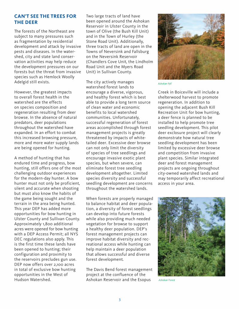
CAN’T SEE THE TREES FOR THE DEER
The forests of the Northeast are subject to many pressures such as fragmentation by residential development and attack by invasive pests and diseases. In the water-shed, city and state land conser-vation activities may help reduce the development pressures on our forests but the threat from invasive species such as Hemlock Woolly Adelgid still exists.
However, the greatest impacts to overall forest health in the watershed are the effects on species composition and regeneration resulting from deer browse. In the absence of natural predators, deer populations throughout the watershed have expanded. In an effort to combat this increased browsing pressure, more and more water supply lands are being opened for hunting.
A method of hunting that has endured time and progress, bow hunting, still offers one of the most challenging outdoor experiences for the modern-day hunter. A bow hunter must not only be proficient, silent and accurate when shooting but must also know the habits of the game being sought and the terrain in the area being hunted. This year DEP has added more opportunities for bow hunting in Ulster County and Sullivan County. Approximately 1,800 additional acres were opened for bow hunting with a DEP Access Permit; all NYS DEC regulations also apply. This is the first time these lands have been opened to hunting; their configuration and proximity to the reservoirs precludes gun use. DEP now offers over 2,100 acres in total of exclusive bow hunting opportunities in the West of Hudson Watershed.
Two large tracts of land have been opened around the Ashokan Reservoir in Ulster County in the town of Olive (the Bush Kill Unit) and in the Town of Hurley (the Stone Road Unit). Additionally, three tracts of land are open in the Towns of Neversink and Fallsburg on the Neversink Reservoir (Chandlers Cove Unit, the Lindholm Road Unit and the Myers Road Unit) in Sullivan County.
The city actively manages watershed forest lands to encourage a diverse, vigorous, and healthy forest which is best able to provide a long term source of clean water and economic benefits to local watershed communities. Unfortunately, successful regeneration of forest areas accomplished through forest management projects is greatly threatened by impacts of white-tailed deer. Excessive deer browse can not only limit the diversity of species of tree seedlings and encourage invasive exotic plant species, but when severe, can eliminate forest tree seedling development altogether. Limited species diversity and successful seedling development are concerns throughout the watershed lands.
When forests are properly managed to balance habitat and deer popula-tion, a diversity of forest seedlings can develop into future forests while also providing much needed vegetation for browse to support a healthy deer population. DEP’s forest management projects can improve habitat diversity and rec-reational access while hunting can help maintain a deer population that allows successful and diverse forest development.
The Davis Bend forest management project at the confluence of the Ashokan Reservoir and the Esopus
Creek in Boiceville will include a shelterwood harvest to promote regeneration. In addition to opening the adjacent Bush Kill Recreation Unit for bow hunting, a deer fence is planned to be installed to help promote tree seedling development. This pilot deer exclosure project will clearly demonstrate how natural tree seedling development has been limited by excessive deer browse and competition from invasive plant species. Similar integrated deer and forest management projects are ongoing throughout city-owned watershed lands and may temporarily affect recreational access in your area.
Ashokan Fall
Ashokan Forest
34790.indd 3 12/2/10 1:55 PM

4
Recreation Area Closures/ Modifications
Any parcel of city land may be subject to DEP work projects to improve operational infrastructure or allow forest management projects at any time. Although impacts on public access are minimized as much as possible, some conflicts involving closures or re-directed access may occur. Thank you for complying with these restrictions which are necessary to complete work essential for long term water supply protection and to help assure your personal safety.
Currently, you may encounter temporary closures or modified recreational access resulting from ongoing forest management at the following locations:
Ashokan Reservoir Area (Ashokan Forester: Todd Baldwin at 845-340-7854 or email at [email protected] )
• Bushkill Unit, Boiceville. Gate W-12, 48 acres including the west side of the Esopus Creek below the Rt.28A (“Five Arches”) bridge and south to the Reservoir headwaters at the “Chimney Hole.”
• Acorn Hill Unit, Olive. Eastern 95 acre portion, south side of Rt. 28A between the main dam and Yale Quarry.
Rondout Reservoir Area (Rondout Forester: Nate Hart at 845-334-7125 x129 or email at [email protected])
• South Rondout Unit, Wawarsing, 50 acre portion west of the inter-section of Route 55 and Sherman Road including the gated entrance on the west side of Sherman Road.
NO
TRESPASSING
FOR ANY PURPOSE
Area Temporarily Closed
Forest Management ProjectIn Progress
Please Contact the DEP Forestry Coordinatorat 845-340-7863 if any questions.
ESOPUS CREEK TELEMETRY STUDY
The effects of the cold and at times turbid water releases from Schoharie Reservoir on the Esopus Creek trout fishery have been an area of attention for many years. Trout need cold, clean water to survive; turbid water can have an adverse effect on survival, habitat, macroinvertebrate forage species, feeding efficiency, behavior and growth. To study these effects, DEP, the US Geological Survey, NYS Department of Environmental Conservation, Cornell Cooperative Extension of Ulster County, Cornell University and Trout Unlimited have begun the second year of a three-year cooperative study in the Upper Esopus Creek. As happened last year, radio-frequency transmitters were surgically implanted in wild rainbow trout and hatchery-raised and wild brown trout. The fish were then released both upstream and downstream of the Shandaken Portal. A Cornell graduate student and agency staff tracked and monitored trout location, movement and fish temperature in both study reaches. The data collected will be analyzed to determine (a) rates of movement, (b) availability and utilization of thermal refuges, (c) apparent survival rates of fish in reaches upstream and downstream of the Portal.
Esopus Creek anglers who catch any study trout are asked to release fish unharmed if possible. If the fish is mortally injured or found dead, please contact the DEP Fisheries Biologist at 845-340-7857 so we can retrieve the radio tags. Any dead fish collected from the study will be submitted to the College of Veterinary Medicine at Cornell University for pathology.
TRAIL PARTNERSHIPS
Work is progressing on two new trail projects that will enhance recreational opportunities in the communities of Carmel, Putnam County and Yorktown, Westchester County. The partnerships between the city, as property owner, and the trail sponsors Putnam County and Teatown Lake Reservation, are governed by recreational land use permits developed by DEP’s Natural Resources Management staff. The
land use permit requirements ensure that trail construction and installation of related improvements such as bridges, benches and kiosks is done without adverse impacts to water quality.
Lake Gleneida Trail: Staff of Putnam County’s Parks Department have constructed a 1.5 mile trail along the western and northern shore of Lake Gleneida, one of three controlled lakes in the city’s East-of-Hudson
Trout Telemetry Sign
Continued on top of page 5
Trout Monitoring, Esopus Creek

5
Watershed. The trail winds along the shoreline through beautiful mature woods with impressive specimen trees of oak, tulip poplar and willow. Interpretive kiosks will inform visitors of the area’s cultural heritage and land use history, and the trail’s proximity to the high school in Lake Carmel make it an excellent location for environmental education programs.
Teatown-Kitchawan Trail: Teatown Lake Reservation is a nonprofit, environmental organization with an 834-acre nature preserve and education center located in the Towns of Yorktown, Cortlandt, and New Castle. Completion of the Teatown-Kitchawan Trail will link two County Parks, the Kitchawan Preserve and John Hand Park, with Reservation lands providing
miles of wooded hiking trails in the heart of Westchester suburbs.
The two miles of connecting trail that run through city lands (Pre-Memorandum of Agreement
buffer along the New Croton Reservoir and two recent acquisitions of the watershed protection programs) offer a variety of recreational opportunities. While some sections of the trail are newly constructed and blazed, much follows former woods roads and paths and a portion of the old Croton Dam Road, offering excellent views across the reservoir.
Other trail partnership projects include a proposal from the Somers Land Trust to connect trails on the Town of Somers Angle Fly Preserve with those on neighboring city lands. The Pound Ridge Land Conservancy has also been working with DEP to facilitate a trails project through lands adjoining the Cross River Reservoir.
ZEBRA AND QUAGGA MUSSELS
Zebra Mussels and Quagga Mussels are non-native, nuisance, aquatic species found widely in the United States. Once introduced into lakes and rivers, they kill off native mollusks and compete with zooplankton for food, in turn affecting natural food webs.
Native to the Caspian and Black Seas, Zebra Mussels (Dreissena polymorpha) are tiny black-and-white striped bivalve mollusks (relatives of clams and oysters) that invaded North American freshwater and estuarine systems in the 1980s. They came to the United States through ballast water released from foreign ships and colonized most major river systems in and near the Great Lakes basin and elsewhere throughout the country. Along with the potential to do serious ecological damage, the mussel species have the ability to clog pipes and mechanical systems of water supply intake chambers, dams and other infrastructure costing millions of dollars in control and damage. These
mussels are hitchhikers and easily transported on boats, trailers, and other recreational watercraft.
Zebra Mussels grow in dense clusters that contain numerous individuals attached firmly to surfaces by strong adhesive threads called byssal fibers. These mussels will attach and colonize on almost any surface type including metal, rubber, glass and cloth but have been a problem particularly in utility plant intake pipes, which have a constant water
current important for mussel growth. Zebra Mussels look like small clams with elongated yellow and /or brown “D” shaped shells. They are usually marked with alternating light and dark herringbone bands, but the number and pattern of the bands or stripes is highly variable. Most Zebra Mussels are thumbnail size, but some grow up to two inches long.
Quagga Mussels (Dreissena bugensis) are closely related to the Zebra Mussel and are native to the Caspian Sea drainage in Eurasia. Like the Zebra Mussel, Quagga Mussels most likely arrived as stowaways in the ballast water of oceangoing ships. Quagga Mussels can tolerate a wider range of temperature extremes than Zebra Mussels and can settle on and colonize muddy and sandy bottoms in extreme depths. Since Zebra Mussels cannot survive this range of conditions, they can thrive in areas that Zebra Mussels cannot and may be displacing Zebra Mussels in some areas.
Unlike the Zebra Mussel, the Quagga Mussel shell has a rounded angle or Continued on top of page 6
Dreissena polymorpha
(actual size is 15 mm)
Sits flat on ventral side
Triangular in shape
Color patterns vary
Topples over: will not sit flat on ventral side
Rounder in shape
Usually have dark concentric rings on shell
Paler in color near the hinge
Dreissena bugensis
(actual size is 20 mm)
Old Road, Teatown Kitchawan Trail
34790.indd 5 12/2/10 1:56 PM

6
carina. The Quagga Mussel is light tan to almost white, with narrow stripes or mottled lines. It is fan-shaped, with pointed edges at either side. The ventral (bottom-side where the two shells attach) side of the Quagga Mussel is convex which makes the Quagga Mussel topple over when placed ventral side down on a flat surface. The Zebra Mussel will remain upright when placed in this position.
So far, the Quagga Mussel has a more limited distribution in the US, occurring mainly around the Great Lakes, but may be able to successfully invade inland lakes including those not suitable for Zebra Mussel establishment.
Although Zebra and Quagga Mussels can be transported naturally via water currents and waterfowl, it is believed that the rapid expansion from the
Great Lakes to other inland freshwater systems is attributed to dispersal influences through human activities. Transportation from infested waters to noninfested waters can occur by boats, trailers, and anglers. Juvenile and adult mussels can attach themselves to ship and recreational boat hulls and trailers. Additionally, the microscopic mussel larvae can easily be transported in ballast water, boat bilge, engine cooling systems, bait buckets, and live wells. This inadvertent transportation of larval mussels has likely enhanced the bivalve’s dispersion and rapid expansion into noninfested inland waters of the United States.
How can you help prevent their spread?
1. INSPECT and CLEAN any mussels and aquatic vegetation from the boat hull, trailer, anchor,
anchor rope or chain, and motor. If you see any “hitchhiking” Zebra Mussels, scrape them off and discard in a trash can.
2. DRAIN all water from the boat and its components. Before leaving the infested area, drain bilge water, live wells, bait buckets, and engine cooling water.
3. DRY the boat, trailer, and equipment. Allow the boat and trailer to dry thoroughly in the sun before transporting to noninfested waters. If it is hot and dry, leaving the boat out of the water for two to four days will effectively kill the mussels.
4. LEAVE any live bait behind. Bait used in infested waters should not be transported to noninfested waters. Give the bait to someone headed out on the body of water you are leaving or discard at the boat launch.
AHOY RESERVOIR BOATERS!
Autumn in the NYC Watersheds is the ideal time to take to the water and see if the fish are biting.
In addition to being the water supply for over nine million New York State residents, city reservoirs are a great destination for fishing by boat. The experience of fishing the city reservoirs by boat has been enjoyed by thousands of anglers over the years and more than one fish story was born on these waters. Sometimes the “one that got away” compels one to return another day.
The recreational use of such an important resource is carefully managed to ensure the overall purpose of water supply is not hampered by recreational uses such as fishing and boating.
Boats must first be steam cleaned and registered with DEP and then left on the shore of the reservoir to be used during open fishing seasons. Unfortunately, many rowboats are left on the shoreline, unused, year after year while the number of new boaters continues to grow. At some reservoirs
there simply is no room for new boats. This situation can result in the loss of opportunity to someone who wants to place a boat on the reservoir for frequent fishing.
If you are a boater who does not use your boat, please consider taking it home or letting a friend use it. The Rules for the Recreational Use of Water Supply Lands and Waters allow a boat owner to loan the boat with a Valid Boat Tag to friends or family with Valid DEP Access Permits and a New York State Fishing License.
Before launching that boat, take a look around the boat storage area. Is it clean and free of litter? Are there bait containers, bottles, or other trash? Most boat areas could use a good clean-up. Please take the time to pick
Improperly stored boat
Continued on top of page 7
34790.indd 6 12/2/10 1:56 PM

7
STUDENTS PLANT TREES TO PROTECT STREAMS AND BEAUTIFY PARKS OF MARGARETVILLE, ROXBURY, AND ANDES
This article was contributed by Adam Stewart who is working as a Student Conservation Association Hudson Valley AmeriCorps intern and has family ties with Delaware County.
Citizens of Margaretville, Roxbury, and Andes can now breathe a little easier. Native trees and shrubs were planted along streams in local parks by schoolchildren and community members from these towns on May 12 and 13. These events were part of the “A Man Who Planted Trees” project initiated by the Catskill Center for Conservation and Development and the Roxbury Arts Group. Representatives from DEP, the Delaware County Soil and Water Conservation District (DCSWCD), Catskill Forest Association, Watershed Agriculture Council, and Catskill Watershed Corporation also contributed to this endeavor. Trees for the plantings were provided by the Catskill Streams Buffer Initiative of DCSWCD and DEP.
Near freezing temperatures and overcast skies failed to discourage Dan Cohen and his fifth grade science class from arriving at Margaretville’s Village Park on the morning of May 12. Short speeches and a brief demonstration were given by attending organizations to
explain their roles in the watershed and the importance of plants in riparian (streamside) areas. Students were then shown the proper technique for installing plants before being cut loose to try it on their own, with the watershed representatives and Mr. Cohen offering assistance when needed. The students dug right into the task, working diligently. The work was dirty and, while several students arrived with green thumbs, they all left with brown hands (and clothes) and big smiles. Everybody had a blast, even when the mist rolled in. When the job was finished, Village Park looked as happy as the kids with its 42 new trees and shrubs.
Similar events were held at Kirkside Park in Roxbury and Andes’ Ballantine Park on May 13, following the same format as at Village Park. The only change was the weather; the sun made its presence in Roxbury before activities began and stayed out all day. Karen Bramley and Alice Fiske arrived with 38 third and fifth graders in tow to plant 30 trees and shrubs throughout Kirkside Park. Again, the students proved to be a reliable workforce and were quick to finish the job. Later in the day, a group of 27 students from third to sixth grade were just as helpful in Andes, adding 30 plants to Ballantine Park. This group, monitored by Robin White and Jennifer Ennist, were such efficient planters they proceeded to patrol the park, cleaning it of debris. George Ballantine was in attendance
to observe the beautification of the land he donated to the Town of Andes.
Overall, the project and plantings were a terrific success. Adding plants to these parks will help provide habitat to wildlife populations, improve water quality, reduce erosion, mitigate flooding, and provide shade and aesthetic improvements for park-goers. Peg Ellsworth, Executive Director of the MARK Project and consultant on the Kirkside Park Project, attended in Roxbury and said of the event, “I am elated that the students of RCS are stewarding the environment in our lovely Kirkside Park. This type of caretaking activity is critical to the long term health of the stream and another contribution to the overall beauty of the park. These students now have a living legacy alongside the East Branch of the Delaware River. And the importance of these events was not lost on the students, one of whom was heard shouting, ‘It’s so cool to help the Earth!’ Similar sentiments were shared by the other children and teachers participating in the plantings.”
This event would not have been possible without the schools, associated organizations, community members, and the involvement of the municipalities of Margaretville, Roxbury, and Andes. For information, please contact the Catskill Center for Conservation and Development at 845-586-2611 or www.catskillcenter.org.
up trash around the boat areas. If you carry it in, please carry it out. When you are not using your boat, please store it hull side up to prevent it from filling with rainwater and creating a mosquito hatchery.
And remember your personal flotation devices (PFDs) for you and your passengers. There are recent changes to NYS law regarding when boaters must wear PFDs. For information visit
http://nysparks.state.ny.us/recre-ation/boating/navigation-law.aspx and http://www.uscgboating.org/safety/life_jacket_wear_wearing_your_life_jacket.aspx
34790.indd 7 12/2/10 1:56 PM

8
Contact UsFor immediate Access Permit issuance, printable maps of recreation areas, application forms, answers to frequently-asked questions, recreation rules and regulations, up-to-date recreation area lists, recreation program schedules and other information, go to Recreation on DEP’s Web site at www.nyc.gov/dep.
For permit inquiriesplease e-mail [email protected] or
DEP Access Permits
71 Smith Avenue
Kingston, NY 12401
800-575-LAND (5263)
For information about specific recreation areas, reservoirs,programs such as interpretive hikes and boat storage and registration, call the DEP Regional Office for that area:
Ashokan (Ashokan Reservoir) 845-657-2663
Carmel (East of Hudson Lands) 845-225-8144
Downsville (Pepacton and Cannonsville Reservoirs) 607-363-7009
Gilboa (Schoharie Reservoir) 607-588-6231
Grahamsville (Rondout and Neversink Reservoirs) 845-334-7152
Mahopac (East of Hudson Reservoirs) 914-232-1309
To report dangerous or suspicious activity, water quality threats or to report fish kills on city-owned reservoirs and lands call the DEP Police at 888-H2O-SHED (426-7433).
Watershed Tree Planting
34790.indd 8 12/2/10 1:56 PM