Factors Influencing the Distribution and Characteristics of ...
14
Factors Influencing the Distribution and Characteristics of Surface Sediment in the Bay of Cartagena, Colombia Juan Camilo Restrepo † *, Jaime Escobar ‡§ , Luis Otero † , Diana Franco †† , Jorge Pierini ‡‡ , and Iva ´n Correa §§ † Departamento de F´ ısica Grupo de Geociencias Universidad del Norte Barranquilla, Colombia ‡ Departamento de Ingenier´ ıa Civil y Ambiental Universidad del Norte Barranquilla, Colombia § Center for Tropical Paleoecology and Archeology (CTPA) Smithsonian Tropical Research Institute (STRI) Ciudad de Panama ´, Panama ´ †† Instituto Colombiano del Petr´ oleo Universidad Industrial de Santander Grupo de Investigaci´ on en Estratigraf´ ıa Bucaramanga, Colombia ‡‡ CCT BB (CIC-IADO-UNS-CONICET) Departamento de F´ ısica Universidad Nacional del Sur Bah´ ıa Blanca, Argentina §§ Departamento de Geolog´ ıa Universidad Eafit Medell´ ın, Colombia ABSTRACT Restrepo, J.C.; Escobar, J.; Otero, L.; Franco, D.; Pierini, J., and Correa, I., 0000. Factors influencing the distribution and characteristics of surface sediment in the Bay of Cartagena, Colombia. Journal of Coastal Research, 00(0), 000–000. Coconut Creek (Florida), ISSN 0749-0208. This study evaluated patterns of coastal sediment movement and deposition under different seasonal conditions (warm and cold phases of the El Ni˜ no–Southern Oscillation [ENSO] and normal conditions) in Cartagena Bay, Colombia. A calibrated numerical model (MOHID modeling system) was applied to assess the spatial distribution of sediments transported by the Canal del Dique to the bay and studied the spatial distribution and major textural characteristics of 234 surface sediment samples. Currents in the Bay of Cartagena are controlled primarily by the strength and direction of the wind. Model results show major sediment deposition in the southern sector of the bay during the dry season. More homogenous spatial distribution of sediments throughout the Bay of Cartagena occurs with an increase in river inputs from the Canal del Dique. These patterns were enhanced or weakened, respectively, by cold and warm phases of the ENSO. Predominant sediments were medium size (u ¼ 5.35 6 1.2), poorly sorted (r ¼ 1.63 6 0.8), with notable asymmetry (Sk ¼0.052 6 0.2) and kurtosis (k ¼ 0.84 6 0.4). Sediments with lower sand content (,5%) are located along a latitudinal axis from the Canal del Dique delta to the western end of the island of Tierrabomba. CaCO 3 content of the sediments is ,10%. Water and sediment flow, controlled by the Canal del Dique, has favored the transport and deposition of poorly sorted, symmetric, and mesokurtic mud in most of the Bay of Cartagena. As a result, autogenous calcareous sediments have been covered by fine terrigenous sediments that were delivered via the Canal del Dique. Thus, the channel plays a more prominent role in sediment transport and deposition in the Bay of Cartagena than thought previously. ADDITIONAL INDEX WORDS: Littoral circulation, suspended sediment, textural analysis, Cartagena Bay, fluvial discharge. INTRODUCTION The Bay of Cartagena is located in the Caribbean Sea, off northwestern Colombia. The bay is of great historic, economic, and environmental importance. The city of Cartagena over- looks the bay and is the fifth largest city in Colombia, with ~1,200,000 inhabitants. It was founded in 1533, making it one of the oldest colonial cities in America and it is one of the most important tourist destinations in Latin America. Human occupation in the region has left a record of anthropogenic impacts. At present, the bay receives freshwater and sediment from the Canal del Dique, an artificial channel that connects the Magdalena River, the main waterway of the country, with the bay (Figure 1). The canal was built during the Spanish colonial period to connect Cartagena City directly with the interior of the country via the Magdalena River. Before the construction of the Canal del Dique, Cartagena Bay received no river inputs. The low concentration of suspended sediment and tropical seawater temperatures favored the presence of seagrass beds and coral reefs. The bottom of the bay was dominated by coarse carbonaceous sand, the weathering product of emerged reefs and coral terraces (Burel and Vernette, 1981; Leble and Cuignon, 1987; Martinez et al., 2010). The construction of the Canal del Dique changed the bay significantly, turning it into an estuarine environment in which terrigenous sediments play a significant role (Andrade et al., 2004; Franco et al., 2013; Restrepo et al., 2014a). Channel modifications through time have changed surface sediment deposition patterns in the bay and caused potential impacts on nearby ecosystems, such as Rosario Islands Natural Park, located ~45 km SW of the bay (Cendales, Zea, and Diaz, 2002; Moreno-Madri ˜ nan et al., 2015; Restrepo et al., 2012), and caused great concern for the environmental health of the bay (Cendales, Zea, and Diaz, 2002; Restrepo et al., 2005). DOI: 10.2112/JCOASTRES-D-15-00185.1 received 23 September 2015; accepted in revision 23 February 2016; corrected proofs received 14 April 2016; published pre-print online 24 May 2016. *Corresponding author: [email protected] Ó Coastal Education and Research Foundation, Inc. 2016 Journal of Coastal Research 00 0 000–000 Coconut Creek, Florida Month 0000
Transcript of Factors Influencing the Distribution and Characteristics of ...

Factors Influencing the Distribution and Characteristics ofSurface Sediment in the Bay of Cartagena, Colombia
Juan Camilo Restrepo†*, Jaime Escobar‡§, Luis Otero†, Diana Franco††, Jorge Pierini‡‡,and Ivan Correa§§
†Departamento de FısicaGrupo de GeocienciasUniversidad del NorteBarranquilla, Colombia
‡Departamento de IngenierıaCivil y Ambiental
Universidad del NorteBarranquilla, Colombia
§Center for Tropical Paleoecologyand Archeology (CTPA)
Smithsonian Tropical ResearchInstitute (STRI)
Ciudad de Panama, Panama
††Instituto Colombiano del PetroleoUniversidad Industrial de Santander Grupo
de Investigacion en EstratigrafıaBucaramanga, Colombia
‡‡CCT BB (CIC-IADO-UNS-CONICET)Departamento de FısicaUniversidad Nacional del SurBahıa Blanca, Argentina
§§Departamento de GeologıaUniversidad EafitMedellın, Colombia
ABSTRACT
Restrepo, J.C.; Escobar, J.; Otero, L.; Franco, D.; Pierini, J., and Correa, I., 0000. Factors influencing the distribution andcharacteristics of surface sediment in the Bay of Cartagena, Colombia. Journal of Coastal Research, 00(0), 000–000.Coconut Creek (Florida), ISSN 0749-0208.
This study evaluated patterns of coastal sediment movement and deposition under different seasonal conditions (warmand cold phases of the El Nino–Southern Oscillation [ENSO] and normal conditions) in Cartagena Bay, Colombia. Acalibrated numerical model (MOHID modeling system) was applied to assess the spatial distribution of sedimentstransported by the Canal del Dique to the bay and studied the spatial distribution and major textural characteristics of234 surface sediment samples. Currents in the Bay of Cartagena are controlled primarily by the strength and directionof the wind. Model results show major sediment deposition in the southern sector of the bay during the dry season.More homogenous spatial distribution of sediments throughout the Bay of Cartagena occurs with an increase in riverinputs from the Canal del Dique. These patterns were enhanced or weakened, respectively, by cold and warm phases ofthe ENSO. Predominant sediments were medium size (u ¼ 5.35 6 1.2), poorly sorted (r ¼ 1.63 6 0.8), with notableasymmetry (Sk ¼�0.052 6 0.2) and kurtosis (k ¼ 0.84 6 0.4). Sediments with lower sand content (,5%) are locatedalong a latitudinal axis from the Canal del Dique delta to the western end of the island of Tierrabomba. CaCO3 contentof the sediments is ,10%. Water and sediment flow, controlled by the Canal del Dique, has favored the transport anddeposition of poorly sorted, symmetric, and mesokurtic mud in most of the Bay of Cartagena. As a result, autogenouscalcareous sediments have been covered by fine terrigenous sediments that were delivered via the Canal del Dique.Thus, the channel plays a more prominent role in sediment transport and deposition in the Bay of Cartagena thanthought previously.
ADDITIONAL INDEX WORDS: Littoral circulation, suspended sediment, textural analysis, Cartagena Bay, fluvialdischarge.
INTRODUCTIONThe Bay of Cartagena is located in the Caribbean Sea, off
northwestern Colombia. The bay is of great historic, economic,
and environmental importance. The city of Cartagena over-
looks the bay and is the fifth largest city in Colombia, with
~1,200,000 inhabitants. It was founded in 1533, making it one
of the oldest colonial cities in America and it is one of the most
important tourist destinations in Latin America. Human
occupation in the region has left a record of anthropogenic
impacts. At present, the bay receives freshwater and sediment
from the Canal del Dique, an artificial channel that connects
the Magdalena River, the main waterway of the country, with
the bay (Figure 1). The canal was built during the Spanish
colonial period to connect Cartagena City directly with the
interior of the country via the Magdalena River. Before the
construction of the Canal del Dique, Cartagena Bay received no
river inputs. The low concentration of suspended sediment and
tropical seawater temperatures favored the presence of
seagrass beds and coral reefs. The bottom of the bay was
dominated by coarse carbonaceous sand, the weathering
product of emerged reefs and coral terraces (Burel and
Vernette, 1981; Leble and Cuignon, 1987; Martinez et al.,
2010). The construction of the Canal del Dique changed the bay
significantly, turning it into an estuarine environment in
which terrigenous sediments play a significant role (Andrade et
al., 2004; Franco et al., 2013; Restrepo et al., 2014a). Channel
modifications through time have changed surface sediment
deposition patterns in the bay and caused potential impacts on
nearby ecosystems, such as Rosario Islands Natural Park,
located ~45 km SW of the bay (Cendales, Zea, and Diaz, 2002;
Moreno-Madrinan et al., 2015; Restrepo et al., 2012), and
caused great concern for the environmental health of the bay
(Cendales, Zea, and Diaz, 2002; Restrepo et al., 2005).
DOI: 10.2112/JCOASTRES-D-15-00185.1 received 23 September 2015;accepted in revision 23 February 2016; corrected proofs received14 April 2016; published pre-print online 24 May 2016.*Corresponding author: [email protected]�Coastal Education and Research Foundation, Inc. 2016
Journal of Coastal Research 00 0 000–000 Coconut Creek, Florida Month 0000

There have been several studies on the sedimentological and
geomorphological characteristics of recent deposits in the Bay
of Cartagena (Andrade et al., 2004; Franco et al., 2013;
Klingebiel and Vernette, 1979; Leble and Cuignon, 1987;
Restrepo et al., 2014; Vernette, Lesueur, and Klingebiel,
1984). Studies show increasing predominance of terrigenous
sediments in the bay, in agreement with the large influence of
river inputs from the Canal del Dique, and an increase in
sediment accumulation at sites within the bay and on the
continental shelf. Textural and CaCO3 analyses of surface
marine sediments around the Rosario Islands Natural Park,
along with satellite imagery analysis, show the expansion of
terrigenous facies at the expense of carbonate facies, as a result
of the progressive increase in continental inputs from the Canal
del Dique (Leble and Cuignon, 1987; Moreno-Madrinan et al.,
2015). Bathymetric surveys conducted between 1935 and 2004
indicate that fine sediments transported by the Canal del
Dique have covered sandy bottoms and advanced about 1 km
north of the channel’s delta (Andrade et al., 2004). At present,
turbidity currents and shallow marine deposits, both delivered
by fluvial processes, are the two main types of recent deposits in
the Bay of Cartagena (Franco et al., 2013; Restrepo et al., 2014).
All previous studies agree that there has been a rapid decline of
sand and CaCO3 content in bottom sediments, particularly in
the Canal del Dique prodelta, and that fine sediments of
terrigenous origin predominate as a result of river inputs
through the Canal del Dique (Andrade et al., 2004; Franco et al,
2013; Restrepo et al, 2014a).
Recent studies suggest that the role of Colombian Caribbean
rivers in the morphological stability of deltas, estuaries, and
beaches, as well as bay sedimentation, increased as a result of
greater river sediment inputs (Restrepo et al., 2014b, 2015a,b).
It has been estimated that all Colombian Caribbean rivers
carry between 147 and 168 3 106 t y�1 of suspended sediment
into the Caribbean Sea, with the Magdalena River accounting
for 97% of this total sediment discharge (Restrepo and Kjerfve,
2004; Restrepo et al, 2015b.). Discharge variability depends
mainly on climate conditions related to the migration of the
Intertropical Convergence Zone (ITCZ) and El Nino–Southern
Oscillation (ENSO) (Restrepo et al., 2014b, 2015a,b). For
example, high rates of suspended sediment transport (223 3
106 t y�1) were recorded in the Magdalena River mouth
between 2010 and 2012 as a result of severe flooding generated
by the La Nina phenomenon (Restrepo et al., 2015b). It has also
been estimated that the annual rate of riverine suspended
sediment transport has increased by 36% between 2000 and
2010 (Restrepo et al., 2015b). Thus, it is possible that
Cartagena Bay is experiencing increased sedimentation rates,
greater abundance of fine sediments of terrigenous origin, and
establishment of an estuarine environment as a result of
increased sediment delivery from the Canal del Dique. Effects
of the Canal del Dique discharge variability (seasonal changes
related to the ITCZ and long-term changes associated with
ENSO) on the bay’s sedimentation processes and sediment
distribution have not been studied.
In the last decade Cartagena has seen a significant increase
in trade and port activities, with an increase of 138% in cargo
moved by sea between 2000 and 2008, from 3.8 3 106 to 9.1 3
106 t y�1 (SPRC, 2009). It is important to determine whether
the progradation of the Canal del Dique delta and sedimenta-
tion processes affect the Port of Cartagena access channel.
There is a need to understand (1) changes in the composition
and distribution of recent sediments in the bay and the
relationship of such changes to riverine inputs, (2) the
importance of river inputs from the Canal del Dique in
sedimentation processes under different climatic–oceano-
graphic scenarios, and (3) the role of coastal circulation
patterns, including their variability, in sediment deposition
processes.
This study explored patterns of coastal sediment movement
and deposition under different seasonal conditions, i.e. warm
and cold phases of the ENSO and normal conditions. This study
also examined the spatial distribution of selected sediment
characteristics (grain size, sorting, skewness, and kurtosis) in
the Bay of Cartagena. The paper aimed to: (1) establish
relationships between patterns of coastal circulation, sedimen-
tation, and surface sediment distribution under different
climate conditions (ENSO and normal conditions) and (2)
determine the influence of the Canal de Dique input variability
Figure 1. Bay of Cartagena map. Computational domain used in the
MOHID model and sediment sample locations (black dots).
0 Restrepo et al.
Journal of Coastal Research, Vol. 00, No. 0, 0000

on the spatial distribution of bottom sediments and their
textural characteristics.
Study AreaThe Bay of Cartagena, Colombia, is located off northeastern
South America (Figure 1). It is separated from the open
Caribbean Sea by Tierrabomba Island. The bay is shallow, with
a surface area of ~82 km2, and mean and maximum depths of
16 and 26 m, respectively. The bay is connected to the
Caribbean Sea through the Bocagrande inlet in the north,
and the Bocachica inlet in the south (Figure 1). The Bocagrande
inlet is restricted by an underwater breakwater that was built
during colonial times. Water depth in the Bocagrande inlet
varies between 0.6 and 2.1 m. The Bocachica inlet reaches a
maximum depth of 15.0 m (Figure 1). Tide in the Bay of
Cartagena is mixed, but mainly diurnal, with a microtidal
range that rarely exceeds 0.5 m (Molares, 2004).
The Bay of Cartagena and its surrounding areas are located
in the Sinu fold belt. The belt is a 7-km-thick sequence of
sandstones, claystones, and carbonate rocks of Miocene to
present age. They are deposited in turbiditic to littoral
environments on an accretionary prism whose morphological
and stratigraphic evolution has been, in part, controlled by
mud diapirism (Duque-Caro, 1984). Coastal hills defining the
depressionary area of the bay have maximum heights of 120 m
and are composed of claystones, sandstones, and reefal rocks
aggregated in the Plio–Pleistocene-age La Popa formation
(Duque-Caro, 1984). Differential coastal uplift associated with
the effects of mud diapirism are conspicuous everywhere along
the western and southern coasts of the bay (Tierrabomba and
northern part of the Baru Peninsula), and are best expressed
by several levels of tilted marine depositional and erosional
terraces with a maximum height of 20 m (Duque-Caro, 1984;
Martınez et al., 2010; Vernette, Lesueur and Klingebiel, 1984).
The area of Mamonal (Figure 1) was made up of a series of
sandstone and limestone hills with heights up to 70 m. Since
1970, limestone mining in the area led to the peneplanation of
this coastal strip and the destruction of natural drains.
The main dry season in the region occurs from December to
February. A weak rainy season occurs between March and May
and there is a weak dry season between June and August. The
main rainy season is from September to November (Mesa,
Poveda, and Carvajal, 1997). During the dry season, NE trade
winds predominate, with average speeds of up to 8.0 m s�1.
During the wet season, the intensity of these winds weakens,
with average speeds of ,3.0 m s�1. Wind conditions, however,
change during ENSO events. An El Nino event brings a
decrease in wind speed from December to May, and an increase
in wind speed from June to November. La Nina events result in
the opposite effect (Ruiz and Bernal, 2009). Consequently, the
warm and cold phases of ENSO may generate differential
patterns of coastal circulation (i.e. Lonin and Giraldo, 1996,
1997; Rueda, Otero, and Pierini, 2013) and of the dispersion of
the Canal del Dique turbidity plume within the bay (i.e. Lonin
et al., 2004; Moreno-Madrinan et al., 2015).
Freshwater discharge from the Canal del Dique (Figure 1)
has had a significant influence on the hydrology and sediment
dynamics of the continental shelf and bay (Andrade et al., 2004;
Leble and Cuignon, 1987; Lonin et al., 2004). Largest water and
sediment discharges are recorded through the Canal del Dique
mouth during November, reaching 800 m3 s�1 and 31 3 103 t
d�1, respectively. Historical records indicate an average flow of
397 m3 s�1 and a sediment transport rate of 5.9 3 106 t y�1
(Restrepo et al., 2005, 2014b). Colombian Caribbean rivers
exhibit strong seasonal variability in flow, usually as high as 5–
10-fold, comparing low to high monthly flow values (Restrepo
and Kjerfve, 2004; Restrepo et al., 2014b). The Canal del Dique
has high interannual river discharge variability, and carries a
large proportion of its sediment load during relatively short
time periods. Between 1984 and 1998 the channel transported
~89 3 106 t of sediment into Barbacoas and Cartagena bays,
about 50% of which was mobilized during only seven extreme
events (Restrepo et al., 2005). Furthermore, ENSO has been
identified as a second-order oscillatory component that influ-
ences hydrologic variability of the Colombian Caribbean rivers
(Restrepo et al., 2014b, 2015a). Thus, the interannual variabil-
ity associated with ENSO can be equal to the variability driven
by ITCZ shifts. A factor of 2 to 4 is seen when comparing low to
high annual streamflow/suspended sediment transport (Re-
strepo and Kjerfve, 2004; Restrepo et al., 2014b, 2015a).
METHODSThis section describes the MOHID modeling system (Martins
et al., 2001) used to assess the spatial distribution of sediments
transported by the Canal del Dique to the Bay of Cartagena.
This section also describes the analysis of the 234 surface
sediment samples collected from the Bay of Cartagena (Figure
1). Fieldwork was carried out between November and Decem-
ber 2009.
Implementation of Littoral Circulation NumericalModels
The MOHID modeling system (Martins et al., 2001) was used
to assess the spatial distribution of sediments transported by
the Canal del Dique to the Bay of Cartagena. MOHID’s
hydrodynamic module calculates and updates information
based on the solution of the primitive Navier–Stokes equations
in a three-dimensional (3D) space for incompressible fluids. A
detailed description of the model is found in Martins et al.
(2001).
The MOHID numerical model was configured in three
dimensions. This numerical approach uses a 3D advection–
diffusion equation to calculate the dispersion and transport of
sediments in the water column, in which the vertical advection
includes the sedimentation rate of the particles. Adsorption
and desorption are considered reactive processes within the
model. These involve both the particulate and dissolved phases
of the substance (i.e. sediment particle) being simulated, in
which the two layers tend to be in balance. This balance is
taken into account in the model by equations proposed by
Hayter and Pakala (1989). The model for the interaction
processes at the water–sediment interface uses an approach
known as ‘‘fluff layer.’’ Both the deposition algorithm (Krone,
1962) and the erosion algorithm (Partheniades, 2009) are based
on the assumption that deposition and erosion never occur
simultaneously, i.e. a particle that reaches the bottom has a
chance of staying there that varies between 0 and 1, because
Surface Sediment in the Bay of Cartagena, Colombia 0
Journal of Coastal Research, Vol. 00, No. 0, 0000
the shear stress oscillates between the upper limit for
deposition and zero.
The bathymetry used in the implementation of the MOHID
model was obtained by integrating available hydrographic
survey charts of the Bay of Cartagena. Chart scales vary
between 1:100,000 and 1:25,000 and cover the entire area of the
Bay of Cartagena and its proximal continental shelf. These
charts were made from bathymetric surveys conducted since
2005. The computational domain used by the numerical model
is shown in Figure 1. The grid spacing implemented in
Cartagena Bay was 50 3 50 m. The total number of grid points
was 2213357 cells in a rectangular grid over the entire area of
study. The 3D numerical model had a vertical discretization in
Cartesian coordinates. The model had five defined layers with
thicknesses of 2.0, 5.0, 5.0, 5.0, and 50.0 m, from the surface to
the bottom.
The boundary conditions of sea level for the outer mesh were
obtained by developing astronomical tide series using an
interpolation method based on the model AG95.1 (Andersen,
Woodworth. and Flather, 1995). Sea-level conditions are
generated for each of the nodes located along the open
boundary. Sea-level conditions are loaded into the model with
a 15-minute temporal resolution format. Wind data were
acquired from daily means from the QuikSCAT satellite. The
database ran from 20 July 1999 to 22 November 2009, and
includes data from this time period. Wind series were acquired
from the node located at 108150 N, 758450 W.
The study considered three global climate scenarios to run
the model: normal year (2006), ENSO-year warm phase (2002),
and ENSO-year cold phase (2008). These scenarios were
selected because of (1) the magnitude of the ENSO events
during those years, (2) the consequent effect on the Canal de
Dique discharge variability (i.e. Restrepo et al., 2014), and (3)
the availability of complete monthly records of suspended
sediment flow and suspended sediment load. In addition,
recent studies show that during the dry season, the ENSO
(warm or cold phase) event does not cause significant changes
in wind direction in the Colombian Caribbean. Changes in wind
direction are more pronounced, however, during the cold phase
of ENSO in the wet season (Ruiz and Bernal, 2009). In the wet
season, winds from the SW and north are more frequent. These
winds are not present in the wet season during in a normal year
or during the warm phase of ENSO (Ruiz and Bernal, 2009).
Wind roses for each of these years are shown in Figure 2.
Additionally, the study accounted for regional seasonal climate
scenarios, i.e. dry and wet seasons, driven by the annual
movement of the ITCZ. The meteorological information
required by the model, such as air temperature, atmospheric
pressure, relative humidity, and solar radiation, were taken
from the weather station located at the Centre for Oceano-
graphic and Hydrographic Caribbean Research (CIOH).
Monthly average water discharge values through the Canal
del Dique to the Bay of Cartagena for normal years, the ENSO
warm phase, and the ENSO cold phase are shown in Figure 3a.
Model parameters such as turbulence, wind drag coefficients,
and bottom and contour friction coefficients for the bay were
calibrated following Rueda, Otero, and Pierini (2013).This
study used the model execution parameters and computational
domain of Rueda, Otero, and Pierini (2013). The model defined
Figure 2. Daily average wind roses for the Bay of Cartagena: (a) 1998
(ENSO warm phase), (b) 2006 (non-ENSO conditions), and (c) 2008 (ENSO
cold phase).
0 Restrepo et al.
Journal of Coastal Research, Vol. 00, No. 0, 0000

a time lapse of 9.8 seconds, a horizontal viscosity (KH) of 0.001
m2 s�1, and a roughness coefficient of 0.0024.
Clays and silts dominate the particle discharge coming out of
the Canal del Dique (Universidad Nacional, 2007). Total
suspended sediment load curves along the Canal del Dique
were obtained from available measurements and analyses of
liquid and solid flows (National University, 2007). Suspended
sediment load for a normal ENSO year, a warm ENSO phase,
and a cold ENSO phase are shown in Figure 3b. The MOHID
system assumes that the transport of cohesive sediment occurs
only in suspension. Thus, transportation depends only on the
advection–diffusion equation, with a settling velocity included
in the vertical advection (Martins et al., 2001). The settling
velocity Ws (m s�1) is calculated, considering the effect of
sediment concentration (C, kg m�3) on flocculation and the
hindered settling effect above a concentration (~20 kg m�3), on
the basis of the formulation proposed by Nicholson and
O’Connor (1986). Models were configured to run through three
consecutive months for each seasonal period (dry, transitional,
and wet) and each potential ENSO phase (normal, warm, and
cold).
Collection and Analysis of Surface SedimentsTwo hundred thirty-four surface sediment samples from the
Bay of Cartagena were collected in this study (Figure 1).
Fieldwork was carried out between November and December
2009. Sediment samples were obtained with a Van Veen grab
operated from a boat equipped with a Garmin GPS system with
an accuracy of 65.0 m. Sample preparation to determine
textural characterization included addition of 0.25 g of
(NaPO3)6 to prevent particle flocculation and drying at 708C
for 24 hours. The grain size distribution of the coarse fraction
(�63 lm) was determined by sample sieving, whereas the grain
size distribution of particles ,63 lm was determined by laser
diffraction analysis using a Lumosed photosedimentator. This
method uses Stokes’ law in an aqueous medium (deionized
water) to calculate grain size distribution curves. The method
is also suitable for clay-size particles, as time measurements
are shorter compared with other methods (Mittal, 2012;
Partheniades, 2009). Texture analysis of the sediment samples
was done with the GRADISTAT program (Blott and Kenneth,
2001), which uses the Folk and momentum measures (Folk and
Ward, 1957) to calculate grain size parameters (i.e. mean,
sorting, skewness, and kurtosis). This approach has been used
by several authors to describe the properties of coastal
sedimentary environments and their relationship with deltaic
and estuarine processes (e.g., Alsharhan and El-Sammak,
2004; Cupul-Magana et al., 2006; Franco et al., 2013; Minh-Duc
et al., 2007; Restrepo et al., 2014a).
RESULTSThis section describes textural characterization and distri-
butional patterns of surficial sediments and the circulation and
sediment patterns in the Bay of Cartagena during different
seasonal conditions, i.e. warm and cold phases of ENSO and
normal conditions.
Textural Characterization and Distributional Patternsof Surficial Sediments
Surface sediment average grain size ranged between�0.54 uand 6.43 u, with a predominance of medium-size sediment
(5.35 u 6 1.2 u). Only 11.5% of the samples were classified as
sand or gravel (u , 4). Sediment sorting ranged from very
poorly to well sorted, with a strong dominance of poorly sorted
sediments (r ¼ 1.63 6 0.8). Sediments showed remarkable
symmetry (Sk¼�0.052 6 0.2), with only 27 samples skewed to
the coarse size and seven samples skewed to the fine size. Most
sediment is classified as very leptokurtic and platykurtic, with
a mean kurtosis (k) of 0.84 6 0.4 (Figure 4).
Average grain size and sediment sorting show an inverse
relationship, useful to identify three associations. The first
association is composed of poorly sorted medium-size sands to
gravel (0 , u , 2). A second group is composed of poorly sorted
fine-size sands to coarse-size mud (2 , u , 5). The third
association, which includes the majority of samples, is
composed of poorly sorted medium-size mud (5 , u , 6)
(Figure 4a). The relation between skewness and kurtosis is
concentrated toward average asymmetry values, with most of
the samples classified as symmetric with a kurtosis ranging
from platykurtic to mesokurtic (Figure 4b). The relation
between asymmetry and sorting showed two main groups.
Most samples are classified as symmetric and poorly sorted,
with a second group composed of sediments that are very poorly
sorted, asymmetric, and skewed toward the coarse size. A small
set of samples (,3%) is composed of sediments that are poorly
sorted with a tendency to fine-size grains (Figure 4c).
Textural parameters and sand percentages from each sample
were analyzed through spatial interpolation (kriging drift) to
determine patterns of surface sediment distribution in the Bay
Figure 3. (a) Monthly average water discharge and (b) monthly average
suspended sediment load from the Canal de Dique to the Bay of Cartagena in
2002 (ENSO warm phase), 2006 (normal conditions), and 2008 (ENSO cold
phase). Data from Instituto de Hidrologıa, Meteorologıa y Estudios
Ambientales de Colombia (IDEAM).
Surface Sediment in the Bay of Cartagena, Colombia 0
Journal of Coastal Research, Vol. 00, No. 0, 0000

of Cartagena (Figures 5 and 6). Samples with sand concentra-
tions greater than 60% are located in the south-central to
eastern area of the island of Tierrabomba, to the north of
Mamonal, to the south of Bocagrande’s breakwater, and in
Bocachica and Manzanillo (Figure 6). These areas are also
characterized by sediments that are very poorly sorted, and
skewed to coarse-size grains (Figures 5b and c). In the Canal
del Dique prodelta and the Coquitos coastal swamp there are
symmetrical, mesokurtic, poorly sorted sediments with inter-
mediate sand content (25–50%) (Figures 5 and 6). The Bay of
Cartagena is, however, dominated by silt and clay grains,
poorly selected, symmetrical, and mesokurtic (Figure 5).
Sediments with the lowest sand content (,5%) are located
along a latitudinal N-S axis from the Canal del Dique prodelta
to the eastern end of the island of Tierrabomba, and in the
central and northern part of the bay (Figures 5a and 6). Along
this latitudinal axis, in the deepest areas of the bay, there are
sediment deposition clusters with poorly sorted material that
contains symmetric to coarse-size grains and is platykurtic
(Figure 5). The inner bay, with the exception of the area north
of the island of Manzanillo, is dominated by poorly sorted,
symmetrical, and mesokurtic fine material (Figure 5).
Circulation and Sedimentation Patterns in the Bay ofCartagena
There are no changes in circulation patterns in the bay
during the dry season for each ENSO phase (normal, warm,
and cold). On the surface, currents move predominantly to the
SW across the bay. Highest current intensities within the bay
are on the west side of the Canal del Dique mouth, with values
between 0.2 and 0.35 m s�1 (Figure 7). Water enters the bay
through the Bocagrande inlet on the north side of the bay, and
exits through the Bocachica and Varadero inlets in the SW area
of the bay. Water currents during this dry season are mainly
governed by the prevailing wind regime. The contribution of
the tidal field to water currents is not significant because of
their microtidal regime. Water from the Canal del Dique
reduces its speed when entering the bay, and connects to the
current that runs along the coast in the southern part of the
bay. Both phases of ENSO (warm and cold) influence the
magnitude of residual surface currents. Magnitudes of residual
surface currents register a slight decrease during the warm
phase of ENSO, especially in the central and SW sectors of the
bay. A slight increase occurs in residual surface currents along
the bay’s coastline. Current magnitudes during the cold phase
of ENSO are very similar to those recorded during a normal
year for the dry season (Figure 7).
Circulation patterns during the wet season in the Bay of
Cartagena vary for each ENSO phase (Figure 7). These
changes occur especially in the north side of the bay. During
the warm ENSO phase currents have a greater intensity with
respect to both normal and cold phases (Figure 7e). The
direction of surface residual currents is, however, the same in
all three ENSO phases (cold, warm, and normal). Currents
have a westward direction in the south bay area and a
northwestward direction in the north and central sector of
Cartagena Bay. In the northern part of the bay, surface
residual currents are less intense. Surface residual net flow
moves out of the bay through both the Bocachica and
Bocagrande inlets during the wet season. This result is
consistent with season dynamics when the greatest suspended
sediments and freshwater contributions and suspended sedi-
ments are recorded through the Canal del Dique. Thus the
ENSO cycle mainly affects current intensity during the rainy
season.
The distribution patterns of sediments coming out of the
Canal del Dique are influenced by seasonality and ENSO
conditions (Figures 8). Highest sediment deposition is recorded
in the outer part of the Canal del Dique mouth because of
flocculation of cohesive sediments and reduction of the
current’s horizontal velocity. Sediments tend to settle in the
southern region of the bay during the dry season. Sediments
are transported mostly by the net residual current along the
coast in this area of the bay. The fraction of sediment that
remains in suspension is redistributed to the central and SW
sector of the bay. Highest deposition of sediment occurs during
the dry season in an ENSO cold phase (Figure 8c). The opposite
occurs during a warm ENSO phase (Figure 8b). This pattern is
strongly related to suspended sediments coming from the
Canal del Dique, as shown in Figures 3a and b.
During the wet season, deposited sediment covers virtually
the entire Bay of Cartagena (Figure 8) in all three ENSO
phases (warm, cold, and normal). This pattern occurs because
(1) during the wet season the largest discharge from the Canal
del Dique enters the Bay of Cartagena, (2) residual surface
currents move from the NE to the west on the central and north
Figure 4. Bivariate figure between (a) mean grain selection and size, (b)
skewness and kurtosis, and (c) selection and asymmetry. Modified from
Restrepo et al., 2014.
0 Restrepo et al.
Journal of Coastal Research, Vol. 00, No. 0, 0000

areas of the bay, and (3) winds from the SW are more frequent,
sometimes generating intense S-to-N currents that are able to
transport sediments to the north side of the bay. The ENSO
event affects the distribution of sediments on the bottom of the
bay. The highest concentration occurs during the cold phase of
ENSO (Figure 8f). This is a consequence of the magnitude of
river inputs from the Canal del Dique. However, it is important
to note that during the wet season, regardless of the ENSO
phase, sediments carried by the Canal del Dique deposit over
the entire Bay of Cartagena, and reach the Bocagrande beaches
outside of the bay (Figure 8).
During the wet season and under the three ENSO phases
(cold, warm, and normal) a residual surface current flows from
the NE to the west. This surface current starts at the mouth of
the Canal del Dique and connects the central area with the
north side of the bay. This current transports sediments to the
north side of the bay that are later transported by a net current
that flows from the central part of the bay toward the inner Bay
of Cartagena and Bocagrande opening (Figure 8f).
Figure 5. Spatial distribution of (a) mean grain size (MGS), (b) sorting (S), (c) skewness (Sk), and (d) kurtosis (k). Thin lines represent depth contours of 5, 15, and
25 m. Modified from Restrepo et al., 2014.
Surface Sediment in the Bay of Cartagena, Colombia 0
Journal of Coastal Research, Vol. 00, No. 0, 0000

DISCUSSIONThis section establishes relationships between patterns of
coastal sediment movement and deposition, and the occurrence
of the ENSO. There is an analysis of the influence of the Canal
de Dique and coastal circulation patterns on the spatial
distribution of bottom sediments and their textural character-
istics.
Links between Circulation/Sedimentation Patterns andSediment Properties
Water and sediment movements in the Bay of Cartagena are
controlled mainly by the wind regime, salinity stratification
caused by the flow of freshwater from the Canal del Dique, and
variations in sea level, i.e. the microtidal range (Lonin and
Giraldo, 1996, 1997; Rueda, Otero, and Pierini, 2013). During
the dry season (December to April) the Canal del Dique
registers its lowest flows (~180 m3 s�1) and stable northeasterly
winds (trade winds), with speeds of ~8 m s�1. During normal
conditions (April–July) the Canal del Dique discharge increas-
es slightly (~250 m3 s�1) and experiences less intense winds (~
5 m s�1) that blow across the Bay of Cartagena from several
directions (N, NE, E, and SE). Although the Canal del Dique
discharge increases significantly (.400 m3 s�1) during the wet
season (August–November), the winds at that time are weak
and blow across the Bay of Cartagena mainly from the SW
(Lonin and Giraldo, 1996; Molares, 2004; Ruız and Bernal,
2009). In summary, the dry season is characterized by low
discharge from the Canal del Dique and strong winds, whereas
the wet season is defined by high river discharge and light
winds. As a result of these hydrodynamic conditions, the Bay of
Cartagena has been classified as a system of moderate to low
energy (Restrepo and Lopez, 2008; Rueda, Otero, and Pierini,
2013). Moreover, its submarine morphology (Figure 9) restricts
exchange of water with the open Caribbean Sea and contrib-
utes to the dissipation of incoming waves (Lonin et al., 2004;
Molares, 2004).
Conditions of moderate to low energy and the seasonal
variability in the circulation patterns of the bay have led to
differences in the spatial distribution of surface sediments
(Figure 5) and created a sedimentary environment character-
ized by poor sorting of the material (Figure 4). The hydrody-
namic model identifies three circulation patterns in the Bay of
Cartagena. During the dry season there are two currents with
magnitudes of 0.1 to 0.2 m s�1 that flow in a N-to-S direction
along the coasts of Tierrabomba and Mamonal islands. There is
also a countercurrent in the central part of the bay that flows in
a S-N direction at speeds of .0.05 m s�1 (Figure 7). In contrast,
during the wet season, the counterflow current reaches the
inner bay and the area of Bocagrande with persistent, but
weaker, velocities (,0.05 m s�1). During this season the two
coastal currents are also considerably weaker (Figure 7).
For the simulated climate years, circulation patterns did not
change during the dry season. During the warm phase of ENSO
of the dry season, the magnitude of the current increases in the
Bay of Cartagena. In the wet season, currents are more intense
during the warm phase of ENSO; whereas during the cold
phase of ENSO, the intensity of these currents decreases.
Currents in the Bay of Cartagena are controlled primarily by
the magnitude and direction of the wind (Lonin and Giraldo,
1996; Lonin et al., 2004; Rueda, Otero, and Pierini, 2013).
Therefore, during the cold phase of ENSO, the intensity and
frequency of the trade winds increases, particularly in the dry
season (Amador, 2008; Ruiz and Bernal, 2009), and there is a
significant reduction in the residual current that flows from
north to south. The ENSO phenomenon also modifies the
patterns of residual currents during the wet season, especially
in the northern part of the Bay of Cartagena. During the warm
phase of ENSO, net flow occurs from the inner bay and
Bocagrande toward the central sector of the Bay of Cartagena.
During the cold phase of ENSO, this current reverses direction,
i.e. it flows toward the inner bay and Bocagrande.
Sediment dispersion modeling shows that during the dry
season, sediment deposition is focused in the south bay sector
(Figure 8). Most of the sediment carried by the Canal del Dique
sinks close to the mouth of the channel once it interacts with the
waters of the Bay of Cartagena. This is a consequence of
flocculation processes, loss of buoyancy, and a reduction in the
strength of the currents. During the wet season, when river
inputs from the Canal del Dique increase, sediments are
Figure 6. Spatial distribution of sand content (%) in surface sediments of the
Bay of Cartagena. Black dotted lines indicate specific sand contents (%)
reported by Pagliardini et al. (1982). Modified from Restrepo et al., 2014.
0 Restrepo et al.
Journal of Coastal Research, Vol. 00, No. 0, 0000

deposited across nearly the entire bottom of the Bay of
Cartagena (Figure 8). During the cold phase of ENSO, sediment
deposition reaches the inner Bay of Cartagena and the Strait of
Bocagrande. This is mainly a consequence of the emergence of a
net flow that begins at the mouth of the Canal del Dique and
connects with coastal backflow compensation currents and with
the current that flows from the center of the bay toward
Bocagrande and the inner Bay of Cartagena (Figure 8f).
Circulation patterns and simulated sedimentation (Fig-
ures 7 and 8) show correspondence with the properties of the
Figure 7. Residual surface currents fields in the Bay of Cartagena during the dry season for (a) normal year, (b) ENSO warm phase, (c) ENSO cold phase; and wet
season for (d) normal year, (e) ENSO warm phase, (f) ENSO cold phase.
Surface Sediment in the Bay of Cartagena, Colombia 0
Journal of Coastal Research, Vol. 00, No. 0, 0000

sediment collected at the bottom of the bay (Figure 5).
Sediment parameters, particularly average grain size,
depend on the dominant oceanographic/fluvial processes
and bottom morphology of the bay. Whereas the distribution
and spatial variability of sediment properties are related to
the energy of transport (amplitude and variability), subma-
rine morphology regulates the mass flows of water and
energy. Sediments of Cartagena Bay are mainly composed of
Figure 8. Distribution of deposited sediments coming out of the Canal del Dique during the dry season for (a) a normal year, (b) ENSO warm phase, (c) ENSO cold
phase; and during the wet season for (d) a normal year, (e) ENSO warm phase, (f) ENSO cold phase. Concentration units for deposited sediments are in kilograms
per square meter. The scale is limited to 15 kg m�2 to better illustrate distribution patterns in the figure. Total modeling time lapse for each season was 4 mo.
0 Restrepo et al.
Journal of Coastal Research, Vol. 00, No. 0, 0000
poorly sorted lithoclastic mud, with a mostly symmetrical
and mesokurtic to platykurtic distribution of grain size
(Figures 4 and 5). Other representative groups are (1) coarse
sands and biolithoclastic muds asymmetric to the fine grain
size and (2) medium-size sands and bioclastic gravels
asymmetric to the coarse grain size (Figure 4 and 5). These
two groups have poorly sorted and leptokurtic to platykurtic
grain size distributions. They are located in the area adjacent
to the central and SE coast of Tierrabomba Island, Man-
zanillo Island, and the central banks of the Bay of Cartagena
(Figure 5). Circulation patterns reveal that intense and
variable coastal edge currents have contributed to the
consolidation of poorly sorted gravels and sands in a strip
near the islands of Tierrabomba and Manzanillo, the area
north of Mamonal, and Bocachica sector (Figures 5, 7, and 8).
These deposits come from the weathered Quaternary terrac-
es located in these areas (e.g., Martınez et al., 2010). On the
other hand, the water and sediment flow controlled by the
Canal del Dique discharge, running from the south to the
north of the bay, has favored the transport and deposition of
poorly sorted, symmetric, and mesokurtic mud in most of the
Bay of Cartagena (Figures 5, 7, and 8). Sediments transport-
ed over relatively long distances are better sorted than those
experiencing in situ weathering processes (Alsharhan and
El-Sammak, 2004; Cupul-Magana et al.,. 2006; Minh-Duc et
al., 2007; Sahu, 1964; Shepard, 1963). In times of high river
discharge, a northbound convective circulation occurs in the
Bay of Cartagena. Freshwater from the Canal del Dique
covers the entire bay with an average thickness of 15 m,
reaching up to 22 m deep at the mouth of the Canal del Dique
and 5 m in Bocachica (Cormagdalena, 2004). During these
periods, the contribution of suspended solids from the Canal
del Dique can reach 313103 t d�1 (Restrepo et al., 2005). This
combination of factors makes possible the transport and
sorting of fine granular material into the Bay of Cartagena.
During the dry and normal periods, the extent of the
convective circulation decreases, and thus the backflow of
the S-N current extends only to the middle area of the bay,
but the Canal del Dique water and sediment discharge still
play a role in determining surface sediment distribution
patterns. Thus circulation and sedimentation patterns
explain (1) the difference in sand content between shallow
and deep areas of the bay, (2) the accelerated progression of
terrigenous facies within the bay, and (3) the presence of fine
sediments of terrigenous origin in the inner Bay of Cartage-
na, the farthest area from river influence.
Role of Canal del Dique in Shifting SedimentationPatterns
Martinez et al. (2010) established that about 2.2 ka before
present the Bay of Cartagena had surface sediments dominat-
ed by carbonate mudstones, with patchy reefs. Progradation of
clastic origin began, however, as a consequence of a larger
coastal dynamic (Burel and Vernette, 1981). Thirty years ago,
Pagliardini et al. (1982) indicated that although the sediments
of the Bay of Cartagena displayed a range of sizes, bioclastic
calcareous sands dominated in areas of gentle slopes such as
Bocagrande, Castillogrande, and the northern area of Tierra-
bomba (Figure 6). Pagliardini et al. (1982) also established that
whereas muddy sediments covered a significant proportion of
the bay, they did not constitute the dominant sediment type.
Distribution of these muds was limited to deep zones protected
by islets and came mainly from river inputs of the Magdalena
River. The Magdalena River empties into the Caribbean Sea
and is located 120 km NE of the Bay of Cartagena. Pagliardini
et al. (1982) considered the effect of the Canal del Dique to be
limited to very local sedimentation processes in the Bay of
Cartagena. They argued that the canal had a relatively low
flow rate (,100 m3 s�1) and most of its sediment load was
deposited in the mouth of Pasacaballos. Subsequently, as a
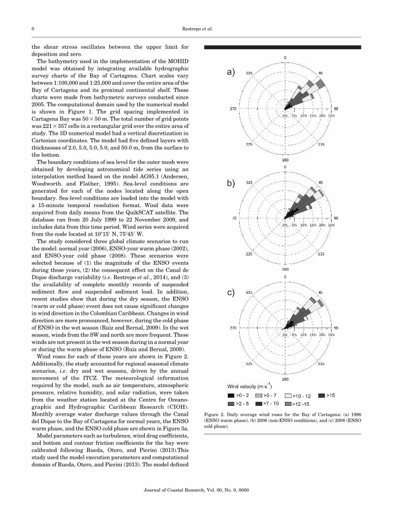
Figure 9. (a) Average monthly flows from the Canal del Dique (Station
Santa. Helena, 1979–2010). The gray bold line represents the annual trend.
Digital terrain models produced from bathymetric information on 1997 (b)
and 2009 (c). The dotted white circle highlights the area of influence of the
Canal del Dique prodelta. Modified from Restrepo et al., 2014.
Surface Sediment in the Bay of Cartagena, Colombia 0
Journal of Coastal Research, Vol. 00, No. 0, 0000

result of increased sediment input from the Canal del Dique
and the formation of lateral bars (~1 km long at the mouth), the
Bay of Cartagena changed from an estuarine to a deltaic
system. It is now characterized by recent progression of
terrigenous facies over carbonaceous and platform facies
(Andrade et al., 2004). So far, no hydrosedimentological study
in the Bay of Cartagena (Andrade et al, 2004; Klingebiel and
Vernette, 1979; MITCH, 1973; Pagliardini et al, 1982; Vernette,
Lesueur, and Klingebiel, 1984) has reported the presence of
sands at the mouth of the Canal del Dique, and the progression
of fine sediments to the southeastern part of the Tierrabomba
Island sector and the internal bay, at the northern end of the
Bay of Cartagena. As a result of the change in sedimentation
patterns the fringe of carbonaceous sands that surrounds
Tierrabomba Island has become narrower and the carbonate
sediments that characterized the inner Bay of Cartagena are
almost completely covered by mud.
Currently, the high content of fine-size sediments in the
bay may be a consequence of contributions of suspended
sediments from the platform, precipitation runoff, occurrence
of mud diapirism, and river discharge through the Canal del
Dique. Contributions from continental drift are limited by
the Bocagrande breakwater and accumulate on beaches
north of Bocagrande (Andrade, Arias, and Thomas, 1988).
Precipitation is relatively low (,1200 mm y�1) and sediment
inputs from runoff are limited to the eastern part of the bay
(Pagliardini et al., 1982). No study has reported mud
diapirism in the Bay of Cartagena or geomorphological
features associated with this process (Andrade et al. 2004;
Klingebiel and Vernette, 1979; Martınez et al., 2010;
Pagliardini et al, 1982; Vernette, Lesueur, and Klingebiel,
1984). Thus, river input from the Canal del Dique is the main
cause for the increase in fine-size sediment content. This
concurs with the increase in riverine input (36%) during
recent years (Restrepo et al., 2014b, 2015a). Restrepo et al.
(2014a) described a modern environment characterized by
fluvial sedimentation in the Bay of Cartagena. According to
the authors, this depositional environment explains the
decline in grain size and the reduction in areas dominated
by autogenous calcareous sediment (Figure 6).
Surface sediment distribution in the Bay of Cartagena is
controlled by fluvial and morphological dynamics of the
Canal del Dique delta. Other studies have obtained similar
results (i.e. Franco et al., 2013; Moreno-Madrinan et al.,
2015; Restrepo et al., 2014a). The Canal del Dique has
discharged into the Bay of Cartagena since 1924. The delta’s
subaquatic portion only began to form, however, at the end of
the 1970s (Cormagdalena, 2004). The interaction between
marine and fluvial environments has led to the formation of
a mixed sedimentary environment with dominant riverine
attributes (Restrepo et al., 2014a). Delta formation has been
enhanced by the increase in riverine inputs to the bay
(Restrepo et al., 2014b). Average monthly flow increased
from 300 m3 s�1 in 1997 to about 600 m3 s�1 in 2010 (Figure
9a). As a result of these changes, the Canal del Dique
prodelta expanded laterally ~1 km and spread ~3 km
northward into the bay (Figures 9b and c). Furthermore,
comparison of bathymetric data collected over a 74-year
period (1935, 1977, and 2004), as well as radiocarbon dating
on samples from the island of Tierrabomba, indicate
sedimentation rates for the Bay of Cartagena ranging from
1.2 to 5.0 cm y�1 (Andrade et al., 2004; Cormagdalena, 2004;
Martinez et al., 2010). These values suggest that mean water
depth in the bay has declined by~0.8 to 3.2 m since 1934 as a
result of sedimentation, mainly induced by the Canal del
Dique fluvial contributions.
CONCLUSIONSCartagena Bay’s sedimentation processes have changed
dramatically, particularly over the past 30 years. Previously,
the bay was characterized by an autogenous sedimentation
process, dominated by silts and bioclastic clays. This study
showed that the accumulation of terrigenous facies is not
isolated, but rather, a generalized process within the bay. As a
consequence of this progression, Cartagena Bay is dominated
by poorly sorted mud, with a symmetrical and mesokurtic–
platykurtic grain size distribution.
The textural characteristics of the surface sediments of the
Bay of Cartagena are determined primarily by the fluvial
dynamics of the Canal del Dique and hydrodynamics in the bay.
Low to moderate energy conditions and seasonal variability of
the bay’s circulation patterns have led to a sedimentary
environment characterized by poorly sorted sediments. Coastal
flows have contributed to the deposition of gravel and poorly
graded sands. Northbound currents within the bay have
favored the transport and deposition of fine, symmetrical,
mesokurtic, and poorly selected sediments in most of the Bay of
Cartagena.
The connection between the Canal del Dique and the Bay of
Cartagena is critical in shaping the bay’s sedimentation
processes. Currently, the interaction between marine and
freshwater environments has created a mixed sedimentary
environment, dominated by riverine attributes. The interac-
tion of depositional environments (with fluvial domain) has led
to: (1) a reduction, since 1980, in the area dominated by
autogenous calcareous sediments, now covered with fine
sediments of terrigenous origin, transported by the Canal del
Dique; (2) presence of sand at the mouth of the Canal del Dique;
and (3) progression of fine sediments to the SE region of the
island of Tierrabomba, and the internal Bay of Cartagena.
ACKNOWLEDGMENTSWe thank the Geosciences Research Group at Universidad
del Norte, the Research Group in Stratigraphy at the
Universidad Industrial de Santander, the Colombian Petro-
leum Institute, and the CIOH. We thank Dr. Mark Brenner
for providing English editing.
LITERATURE CITEDAlsharhan, A. and El-Sammak, A., 2004. Grain-size analysis and
characterization of sedimentary environments of the United ArabEmirates coastal areas. Journal of Coastal Research, 20(1), 464–477.
Amador, J., 2008. The intra-Americas sea low-level jet: Overview andfuture research. Annals of the New York Academy of Sciences,1146(1), 153–188.
Andersen, O.; Woodworth, P., and Flather, R., 1995. Intercomparisonof recent ocean tide models. Journal of Geophysical Research,100(1), 25261–25282.
0 Restrepo et al.
Journal of Coastal Research, Vol. 00, No. 0, 0000

Andrade, C.; Arias, F., and Thomas, T., 1988. Nota sobre la turbidez,circulacion y erosion en la region de Cartagena, Colombia. BoletınCientıfico CIOH, 8, 71–81.
Andrade, C.; Thomas, Y.; Lonin, S.; Parra, C.; Kunesch, S.;Menanteau, L.; Andriau, A.; Pineros C., and Velasco S., 2004.Aspectos morfodinamicos de la bahıa de Cartagena. BoletınCientıfico CIOH, 22, 90–104.
Blott, S.J. and Kenneth, P., 2001. GRADISTAT: A grain sizedistribution and statistics package for the analysis of unconsoli-dated sediments. Earth Surface Processes and Landforms, 26,1237–1248.
Burel, T. and Vernette G., 1981. Evidencias de Cambios del nivel delmar en el Cuaternario de la region de Cartagena. 1er Seminariosobre el Cuaternario en Colombia. Revista CIAF, 6(1–3), 77–92.
Cendales, M.; Zea, S., and Dıaz, J.M., 2002. Geomorfologıa y unidadesecologicas del complejo de arrecifes de las Islas del Rosario e IslaBaru (Mar Caribe, Colombia). Revista de la Academia Colombianade Ciencias Exactas, Fısicas y Naturales, 26(101), 497–510.
Cormagdalena, 2004. Actualizacion del Plan de Manejo Ambiental delos Dragados de Relimpia y Mantenimiento del Canal del Dique.Magdalena, Colombia. Cormagdalena – Laboratorio de EnsayosHidraulicos de las Flores, Documento E-063-032-04, 73p.
Cupul-Magana, L.; Mosso-Aranda, C.; Sierra, J.; Martı, E.; Ferman-Almada, J.; Rodilla, M.; Gonzales del Rıo, J., and Sanchez-Arcilla,A., 2006. Caracterizacion y patrones de distribucion de lossedimentos superficiales en bahıa Cullera, Espana. CienciasMarinas, 32(1), 617–629.
Duque-Caro, H., 1984. Estilo Estructural, Diapirismo y Episodios deAcrecimiento del Terreno Sinu-San Jacinto en el Noroccidente deColombia. Bogota, Colombia. Ingeominas. Boletin Geologico, 27p.
Folk, R. and Ward, W., 1957. Brazos River bar: A study in thesignificance of grain size parameters. Journal of SedimentaryPetrology, 27, 3–26.
Franco, D.; Restrepo, J.C.; Sanabria, N., and Gutierrez, J., 2013.Caracterizacion y distribucion de facies sedimentarias en la bahıade Cartagena, Colombia. Boletın de Geologıa, 35(1), 43–53.
Hayter, E. and Pakala, C., 1989. Transport of inorganic contaminantsin estuarial waters. Journal of Coastal Research, 5(1), 217–230.
Klingebiel, A. and Vernette, G., 1979. Estudio batimetrico ysedimentologico en la plataforma continental entre Cartagena yla desembocadura del rıo Magdalena (Colombia). Boletın CientıficoCIOH, 5, 1–15.
Krone, R., 1962. Flume Studies on the Transport of Sediment inEstuarine Shoaling Processes. Berekley, California: HydraulicEngineering Laboratory, University of California, Berkeley,125p.
Leble, S. and Cuignon, R., 1987. El archipielago de las islas delRosario, estudio morfologico, hidrodinamico y sedimentologico.Boletın Cientıfico CIOH, 7, 37–52.
Lonin, S. and Giraldo, L., 1996. Circulacion de las aguas y transportede contaminantes en la bahıa de Cartagena. Boletın CientıficoCIOH, 16, 15–26.
Lonin, S. and Giraldo, L., 1997. Influencia de los efectos termicos en lacirculacion de la bahıa de Cartagena. Boletın Cientıfico CIOH, 17,47–56.
Lonin, S.; Parra, C.; Andrade, C., and Yves-Francois, T., 2004.Patrones de la pluma turbia del Canal del Dique en la Bahıa deCartagena. Boletın Cientıfico CIOH, 22, 7789.
Martınez, J.I.; Yokoyama, Y.; Gomez, A.; Delgado, A.; Matsuzaki, H.,and Rendon, E., 2010. Late Holocene marine terraces of theCartagena region, southern Caribbean: The product of neotecto-nism or a former high stand in sea-level? Journal of SouthAmerican Earth Sciences, 29, 214–224.
Martins, F.; Neves, R.; Leitao, P., and Silva, A., 2001. 3D modelling inthe Sado estuary using a new generic coordinate approach.Oceanologica Acta, 24, S51–S62
Mesa, O.; Poveda, G., and Carvajal, L., 1997. Introduccion al Clima deColombia. Bogota: Universidad Nacional de Colombia, 390p.
Minh-Duc, D.; Trong-Nhuan, M.; VAN NGOI, Ch.; Nghi, T.; Manh-Tien, D.; Van Weering, C., and Van der Bergh, G., 2007. Sedimentdistribution and transport at the nearshore zone of the Red River
delta, northern Vietnam. Journal of Asian Earth Sciences, 29(1),558–565.
MITCH (Mision Tecnica Colombo Holandesa), 1973. Rıo Magdalenaand Canal del Dique Survey Project. Bogota, Colombia: ReporteTecnico, 329p.
Mittal, K.L., 2012. Particles in Gases and Liquids 1. Detection,Characterization, and Control. New York: Springer, 119p.
Molares, R., 2004. Clasificacion e identificacion de los componentes demarea del Caribe colombiano. Boletın Cientıfico CIOH, 22, 105–114.
Moreno-Madrinan, M.J.; Rickman, D.L.; Ogashawara, I.; Irwin, D.E.;Ye, J., and Al-Hamdan, M.Z., 2015. Using remote sensing tomonitor the influence of river discharge on watershed outlets andadjacent coral reefs: Magdalena River and Rosario Islands,Colombia. International Journal of Applied Earth Observationand Geoinformation, 38, 204–215.
Nicholson, J. and O’Connor, B.A., 1986. Cohesive sediment transportmodel. Journal of Hydraulic Engineering, 112, 621–639.
Pagliardini, J.M.; Gomez, H.; Gutierrez, S.; Zapata, A.; Jurado, J.;Garay, G., and Vernette, G., 1982. Sıntesis del Proyecto Bahıa deCartagena. Boletın Cientıfico CIOH, 4, 49–110.
Partheniades, E., 2009. Cohesive Sediment in Open Channels:Properties, Transport and Applications. Oxford, U.K.: Butter-worth-Heinemann, 358p.
Restrepo, J.C.; Franco, D.; Correa, I.; Escobar, J.; Otero, L., andGutierrez, J., 2014a. Bahia de Cartagena (Colombia): Distribucionde sedimentos superficiales y ambientes sedimentarios. LatinAmerican Journal of Aquatic Research, 41(1), 99–112.
Restrepo, J.C.; Ortız, J.C.; Otero, L.; and Ospino, S., 2015a. Trans-porte de sedimentos en suspension en los principales rıos delCaribe colombiano: Magnitud, tendencias y variabilidad. Revista dela Academia Colombiana de Ciencias, Exactas, Fısicas y Naturales,39(153), 527–546.
Restrepo, J.C.; Ortız, J.C.; Pierini, J.; Schrottke, K.; Maza, M.; Otero,L., and Aguirre, J., 2014b. Freshwater discharge into theCaribbean Sea from the rivers of northwestern South America(Colombia): Magnitude, variability and recent changes. Journal ofHydrology, 509(1), 266–281.
Restrepo, J.C.; Otero, L.; Casas, A.C.; Henao, C., and Gutierrez, J.,2012. Shoreline changes between 1954 and 2007 in the marineprotected area of the Rosario Island Archipelago (Caribbean ofColombia). Ocean and Coastal Management, 69, 133–142.
Restrepo J.C.; Schrottke, K.; Traini, C.; Ortız, J.C.; Orejarena, A.;Otero, L.; Higgins, A.; and Marriaga, L., 2015b. Sedimenttransport regime and geomorphological change in a high dis-charge tropical delta (Magdalena River, Colombia): Insights froma period of intense change and human intervention (1990–2010).Journal of Coastal Research. In press. doi:10.2112/JCOASTRES-D-14-00263.1
Restrepo, J.D. and Kjerfve, B., 2004. The Pacific and Caribbean riversof Colombia: Water discharge, sediment transport and dissolvedloads. In: Lacerda, L.; Santelli, R.; Duursma, E., and Abrao, J.(eds.), Environmental Geochemistry in Tropical and SubtropicalEnvironments. Berlin: Springer–Verlag, pp. 169–187.
Restrepo, J.D., and Lopez, S., 2008. Morphodynamics of the Pacificand Caribbean deltas of Colombia – South America. Journal ofSouth American Earth Sciences, 25(1), 1–21.
Restrepo, J.D.; Zapata, P.; Dıaz, J.M.; Garzon-Ferreira, J.; Garcıa, C.,and Restrepo, J.C., 2005. Aportes fluviales al Mar Caribe yevaluacion preliminar del impacto sobre los ecosistemas costeros.In: Restrepo, J.D. (ed.), Los Sedimentos del Rıo Magdalena: Reflejode la Crisis Ambiental. Medellin, Colombia: Fondo EditorialUniversidad EAFIT, pp. 187–215.
Rueda, J.; Otero, L., and Pierini, O., 2013. Caracterizacion hidrodina-mica en un estuario tropical de Suramerica con regimen micro-mareal mixto (Bahıa de Cartagena, Colombia). Boletın CientıficoCIOH, 31, 159–174.
Ruiz, M.A. and Bernal, G., 2009. Variabilidad estacional e interanualdel viento en los datos de Reanalisis NCEP/NCAR en la cuencaColombia, Mar Caribe. Avances en Recursos Hidraulicos, 20(1), 7–20.
Surface Sediment in the Bay of Cartagena, Colombia 0
Journal of Coastal Research, Vol. 00, No. 0, 0000

Sahu, B., 1964. Depositional mechanism from the size analysis ofclastic sediments. Journal of Sedimentary Petrology, 34, 73–83.
Shepard, F., 1963. Submarine Geology. New York: Harper and Row,557p.
SPRC (Sociedad Portuaria Regional de Cartagena), 2009. ActualidadPortuaria – Estadısticas. Cartagena, Colombia: Sociedad Portua-ria.
Universidad Nacional, 2007. Estudios e Investigaciones de las Obrasde Restauracion Ambiental y de Navegacion del Canal del Dique.Bogota, Colombia: Universidad Nacional de Colombia, 295p.
Vernette, J.G.; Lesueur, P, and Klingebiel, A. 1984. Evolucionmorfologica y sedimentologica de la flecha litoral del Laguito(Bahıa de Cartagena, Colombia). Boletın Cientıfico CIOH, 5, 3–23.
0 Restrepo et al.
Journal of Coastal Research, Vol. 00, No. 0, 0000
![Fine-GrainedAnalysisofStabilityandGeneralizationforyy298919/ICML20.pdfscale stochastic optimization algorithms was established in Bousquet & Bottou [4], where three factors influencing](https://static.fdocuments.us/doc/165x107/5f41857144f9304777233422/fine-grainedanalysisofstabilityandgeneralizationfor-yy298919icml20pdf-scale-stochastic.jpg)