
Fact Sheet United States Geological Survey - USGS · Fact Sheet United States Geological Survey ......
4
Fact Sheet United States Geological Survey Programs in Alaska The USGS provides maps, reports, and information to help others meet their needs to manage, develop, and protect America's water, energy, mineral, and land resources. We help find natural resources needed to build tomorrow, and supply scientific understanding needed to help minimize or mitigate the effects of natural hazards and environmental damage caused by human activities. The results of our efforts touch the daily lives of almost every American. For more than 100 years, the U.S. Geo- logical Survey (USGS) has been explor- ing, mapping, describing, and seeking to understand Alaska's earth resources. Today's issues are more pressing than ever understanding natural hazards so they can be avoided or anticipated, the continuing need for resource develop- ment, describing the occurrence of hazar- dous materials and predicting their fate, and understanding the effects of climate change on the water and energy budgets of Alaska, and the effect of Alaska on global climate. The USGS works with State, local, and other Federal agencies as the nation's lead earth science agency to make Alaska more productive and safer. Natural Hazards One of the most visible roles of the USGS is to define and predict natural hazards. Volcanic eruptions, earth- quakes, and floods generally cannot be forecast more than a few days or weeks in advance, if at all. However, the chances of having one of these natural disasters occur or the potential damage from one of these events often can be determined rather accurately by studying the recent and not-so-recent history of the Earth. The Alaska Volcano Observatory (AVO) was established in 1988 to monitor volcanoes, issue eruption notifi- cations, assess volcanic hazards, and conduct volcano research in Alaska. Effective notifications and advance warn- ings during the 1989-90 eruptions of Redoubt and the 1992 eruptions of Spurr increased public safety and helped mini- mize the impacts of those events. More than 40 volcanoes in Alaska are capable of erupting ash into international air traffic routes. The volcanoes are in an arc that stretches 1,000 miles along the Aleutian Islands, up the Alaska Peninsula, and into Cook Inlet (fig. 1). In the past 25 years, damage to aircraft engines from volcanic ash has totaled over $400 million. The AVO provides all-weather, near- and real-time warning of volcanic eruptions by using seismic data, closed- circuit television, and a lightning-detec- tion system for four of these volcanoes. The AVO works with other agencies to track ash, which cannot be detected by onboard instrumentation, and to provide warnings to aircraft of the presence and likely path of an ash cloud. The AVO is a cooperative program of the USGS, the University of Alaska Geophysical Insti- tute, and the Alaska Division of Geolog- ical and Geophysical Surveys. Alaska is the most earthquake-prone State in the Nation. The second largest earthquake (magnitude 9.2) in the world during this century struck the Prince William Sound-Kenai Peninsula Kodiak Island region in 1964, and 68 additional magnitude 7 or greater shocks, including 3 within 50 miles of Fairbanks, have struck in or adjacent to Alaska since 1900. Strong shaking, ground failure, and tsunami inundation individually or in combination threaten the safety and property of most Alaskans and much of the State's infrastructure. The USGS, in cooperation with other agencies, monitors earthquake activity and crustal strain, finds buried earthquake faults, determines prehistoric dates and repetition rates of major earthquakes, maps the extent and severity of geologic earthquake hazards in populated areas, and provides rapid tech- nical information to cope with earthquake disasters. Information derived by the USGS and its collaborators serves as the foundation to devise and improve strate- gies for minimizing fatalities, property losses, and disruption of communications and transportation facilities during future earthquakes (fig. 2). Hazards from floods, debris flows, and channel migration threaten lives and property, annually cause tens of millions of dollars in property damage and remedi- ation costs, and disrupt commerce. Most POLAR ROUTES EXPLANATION O ACTIVE VOLCANO -ZONE OF GREATEST ASH HAZARD Figure 1. International air traffic and volcanic-ash hazards in Alaska.
Transcript of Fact Sheet United States Geological Survey - USGS · Fact Sheet United States Geological Survey ......

Fact Sheet
United States Geological SurveyPrograms in Alaska
The USGS provides maps, reports, and information to help others meet their needs to manage, develop, and protect America's water, energy, mineral, and land resources. We help find natural resources needed to build tomorrow, and supply scientific understanding needed to help minimize or mitigate the effects of natural hazards and environmental damage caused by human activities. The results of our efforts touch the daily lives of almost every American.
For more than 100 years, the U.S. Geo logical Survey (USGS) has been explor ing, mapping, describing, and seeking to understand Alaska's earth resources. Today's issues are more pressing than ever understanding natural hazards so they can be avoided or anticipated, the continuing need for resource develop ment, describing the occurrence of hazar dous materials and predicting their fate, and understanding the effects of climate change on the water and energy budgets of Alaska, and the effect of Alaska on global climate. The USGS works with State, local, and other Federal agencies as the nation's lead earth science agency to make Alaska more productive and safer.
Natural Hazards
One of the most visible roles of the USGS is to define and predict natural hazards. Volcanic eruptions, earth quakes, and floods generally cannot be forecast more than a few days or weeks in advance, if at all. However, the chances of having one of these natural disasters occur or the potential damage from one of these events often can be determined rather accurately by studying the recent and not-so-recent history of the Earth.
The Alaska Volcano Observatory (AVO) was established in 1988 to monitor volcanoes, issue eruption notifi cations, assess volcanic hazards, and conduct volcano research in Alaska. Effective notifications and advance warn ings during the 1989-90 eruptions of Redoubt and the 1992 eruptions of Spurr increased public safety and helped mini mize the impacts of those events.
More than 40 volcanoes in Alaska are capable of erupting ash into international air traffic routes. The volcanoes are in an arc that stretches 1,000 miles along the Aleutian Islands, up the Alaska Peninsula, and into Cook Inlet (fig. 1). In the past 25 years, damage to aircraft engines from
volcanic ash has totaled over $400 million. The AVO provides all-weather, near- and real-time warning of volcanic eruptions by using seismic data, closed- circuit television, and a lightning-detec tion system for four of these volcanoes. The AVO works with other agencies to track ash, which cannot be detected by onboard instrumentation, and to provide warnings to aircraft of the presence and likely path of an ash cloud. The AVO is a cooperative program of the USGS, the University of Alaska Geophysical Insti tute, and the Alaska Division of Geolog ical and Geophysical Surveys.
Alaska is the most earthquake-prone State in the Nation. The second largest earthquake (magnitude 9.2) in the world during this century struck the Prince William Sound-Kenai Peninsula Kodiak Island region in 1964, and 68 additional magnitude 7 or greater shocks, including 3 within 50 miles of Fairbanks, have struck in or adjacent to Alaska since 1900. Strong shaking, ground failure, and tsunami inundation individually or in combination threaten the safety and property of most Alaskans and much of
the State's infrastructure. The USGS, in cooperation with other agencies, monitors earthquake activity and crustal strain, finds buried earthquake faults, determines prehistoric dates and repetition rates of major earthquakes, maps the extent and severity of geologic earthquake hazards in populated areas, and provides rapid tech nical information to cope with earthquake disasters. Information derived by the USGS and its collaborators serves as the foundation to devise and improve strate gies for minimizing fatalities, property losses, and disruption of communications and transportation facilities during future earthquakes (fig. 2).
Hazards from floods, debris flows, and channel migration threaten lives and property, annually cause tens of millions of dollars in property damage and remedi ation costs, and disrupt commerce. Most
POLAR ROUTES
EXPLANATION
O ACTIVE VOLCANO
-ZONE OF GREATEST ASH HAZARD
Figure 1. International air traffic and volcanic-ash hazards in Alaska.
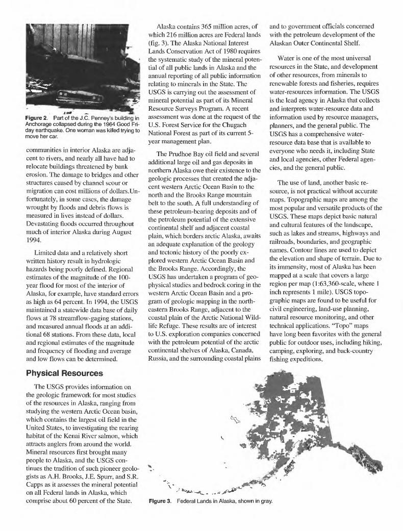
Figure 2. Part of the J.C. Penney's building in Anchorage collapsed during the 1964 Good Fri day earthquake. One woman was killed trying to move her car.
communities in interior Alaska are adja cent to rivers, and nearly all have had to relocate buildings threatened by bank erosion. The damage to bridges and other structures caused by channel scour or migration can cost millions of dollars .Un fortunately, in some cases, the damage wrought by floods and debris flows is measured in lives instead of dollars. Devastating floods occurred throughout much of interior Alaska during August 1994.
Limited data and a relatively short written history result in hydrologic hazards being poorly defined. Regional estimates of the magnitude of the 100- year flood for most of the interior of Alaska, for example, have standard errors as high as 64 percent. In 1994, the USGS maintained a statewide data base of daily flows at 78 streamflow-gaging stations, and measured annual floods at an addi tional 68 stations. From these data, local and regional estimates of the magnitude and frequency of flooding and average and low flows can be determined.
Physical Resources
The USGS provides information on the geologic framework for most studies of the resources in Alaska, ranging from studying the western Arctic Ocean basin, which contains the largest oil field in the United States, to investigating the rearing habitat of the Kenai River salmon, which attracts anglers from around the world. Mineral resources first brought many people to Alaska, and the USGS con tinues the tradition of such pioneer geolo gists as A.H. Brooks, I.E. Spurr, and S.R. Capps as it assesses the mineral potential on all Federal lands in Alaska, which comprise about 60 percent of the State.
Alaska contains 365 million acres, of which 216 million acres are Federal lands (fig. 3). The Alaska National Interest Lands Conservation Act of 1980 requires the systematic study of the mineral poten tial of all public lands in Alaska and the annual reporting of all public information relating to minerals in the State. The USGS is carrying out the assessment of mineral potential as part of its Mineral Resource Surveys Program. A recent assessment was done at the request of the U.S. Forest Service for the Chugach National Forest as part of its current 5- year management plan.
The Prudhoe Bay oil field and several additional large oil and gas deposits in northern Alaska owe their existence to the geologic processes that created the adja cent western Arctic Ocean Basin to the north and the Brooks Range mountain belt to the south. A full understanding of these petroleum-bearing deposits and of the petroleum potential of the extensive continental shelf and adjacent coastal plain, which borders arctic Alaska, awaits an adequate explanation of the geology and tectonic history of the poorly ex plored western Arctic Ocean Basin and the Brooks Range. Accordingly, the USGS has undertaken a program of geo physical studies and bedrock coring in the western Arctic Ocean Basin and a pro gram of geologic mapping in the north eastern Brooks Range, adjacent to the coastal plain of the Arctic National Wild life Refuge. These results are of interest to U.S. exploration companies concerned with the petroleum potential of the arctic continental shelves of Alaska, Canada, Russia, and the surrounding coastal plains
and to government officials concerned with the petroleum development of the Alaskan Outer Continental Shelf.
Water is one of the most universal resources in the State, and development of other resources, from minerals to renewable forests and fisheries, requires water-resources information. The USGS is the lead agency in Alaska that collects and interprets water-resource data and information used by resource managers, planners, and the general public. The USGS has a comprehensive water- resource data base that is available to everyone who needs it, including State and local agencies, other Federal agen cies, and the general public.
The use of land, another basic re source, is not practical without accurate maps. Topographic maps are among the most popular and versatile products of the USGS. These maps depict basic natural and cultural features of the landscape, such as lakes and streams, highways and railroads, boundaries, and geographic names. Contour lines are used to depict the elevation and shape of terrain. Due to its immensity, most of Alaska has been mapped at a scale that covers a large region per map (l:63,360-scale, where 1 inch represents 1 mile). USGS topo graphic maps are found to be useful for civil engineering, land-use planning, natural resource monitoring, and other technical applications. "Topo" maps have long been favorites with the general public for outdoor uses, including hiking, camping, exploring, and back-country fishing expeditions.
Figure 3. Federal Lands in Alaska, shown in gray.

Since 1980, the USGS has supported Federal and State land-management agen cies with a state-of-the-art computer image and geoprocessing laboratory, cooperatively developing land-cover and spatial data bases for more than 270 million acres of the State, relying heavily on satellite image data. Most recently, the USGS has initiated a multiresolution land-characterization project in Alaska with the National Park Service. In 1989, as part of the USGS Global Change Research Program, an Arctic Processes and Land Characterization Project was begun. Since then, the project has grown into an international activity including circumpolar vegetation and ecoregion mapping activities.
This USGS project has contributed substantially to the Alaska geographic information system community, by supporting cooperative data-base devel opment and data-sharing activities and pioneering techniques for processing satellite imagery in support of the infor mation needs of the USGS and other Federal and State agencies.
Investigations of Hazardous Waste
Urban expansion in the vicinity of industrial, military, and other Federal facilities; abandonment of airfields and military sites; enforcement of environ mental legislation; and a general desire to clean up contaminated water bodies and aquifers require documentation of local geologic and hydrologic conditions (fig. 4). The potential for petroleum products, solvents, and other contaminants to degrade surface and ground water used for domestic purposes or by wildlife used for subsistence is a concern to many Alas- kans. The USGS in Alaska provides data collection and interpretation in areas
Figure 4. Completing a well on Kodiak Island to be used in hazardous waste investigation.
where existing data are sparse and where the effects of the Arctic climate on hydro- logic processes are poorly documented or understood.
The resulting data bases are used to help in establishing baseline concentra tions of constituents and to determine locations of monitoring facilities. Where sufficient data exist, USGS ground-water and surface-water models are used to esti mate the effects of changing hydrologic conditions, predict flow paths, or assess the effect of remediation. USGS research into methods to enhance the activity of naturally occurring microbes that remove hazardous material from ground and surface water is especially critical in arctic regions where standard remediation is often prohibitively expensive.
In March 1989, the largest oil spill in U.S. history occurred when a supertanker struck submerged rocks outside of the shipping lanes in Prince William Sound, seriously affecting the tourist and fishing industries there. Immediately following the spill, the USGS began a series of studies of the movement and fate of the spilled oil. These studies resulted in the discovery that, in addition to weathered products from the 1989 spill, other oil residues from an unexpected source are widely distributed in the western part of the sound. These oil products had been spilled into the sound before 1989; the Great Alaska Earthquake of 1964, for example, caused extensive spillage of these products from onshore storage plants. New knowledge has been gained concerning the distribution and long-term weathering effects of spilled oil residues.
Radionuclide and chemical contami nants being released to the Arctic from sites in the former Soviet Union are com monly bound to sediments and trans ported great distances by arctic sea ice. This sediment could potentially contami nate fisheries and marine mammals of northern Alaska. The USGS has been an international leader in polar geologic studies for more than 20 years, and re searchers at the USGS are now leading national and international teams studying sediment and contaminant transport and deposition by ice.
Global ChangeThe Arctic and subarctic play impor
tant roles in global climate, as a control
on atmospheric circulation patterns and as a sensitive indicator of climatic changes. The Arctic is targeted by global change researchers as the region of the globe that will experience the earliest and most sig nificant impacts should climatic change occur. Small changes in temperature or precipitation that may have little effect in temperate regions can cause dramatic changes to permafrost regions, glaciers, or sea ice coverage.
Arctic and Boreal ecosystems are probably the most pristine, fragile, and least studied of any in the world. The USGS, working cooperatively with other Federal Agencies, has undertaken a program to develop a comprehensive geographic information system data base aimed at the information needs of scien tists and resource managers studying global change in Alaska and the Arctic.
Preserving wetlands is an important national issue. Wetlands cover about 270,000 square miles of Alaska, more than the total wetland area of the other 49 States. Wetlands provide essential habitat for much of Alaska's varied and abundant wildlife. In addition, wetlands of the Arctic Coastal Plain are important habi tats for migratory waterfowl. The USGS is studying the effects of past climatic changes on wetlands of the Arctic Coastal Plain to predict the effects of future climatic change on this important eco system. Climatic changes over the past 20,000 years have caused repeated and significant reductions and expansions in the area of wetlands. Ongoing investiga tions will seek to determine the influence of changes in mean annual air tempera ture, precipitation, and the depth to per mafrost (perennially frozen ground) on these changes.
Sea ice conditions on the Arctic Ocean are a prime driver of global climate. It is, therefore, important to monitor seasonal changes in Arctic ice packs and to estab lish the detailed climatic history of the Arctic Ocean during the ice ages, a period of cyclically expanding and contracting glaciers and rising and falling sea levels. This understanding should permit scien tists to recognize the early signs of global climate change and to assess potential causes, such as an apparent increase in atmospheric carbon dioxide during the industrial age.
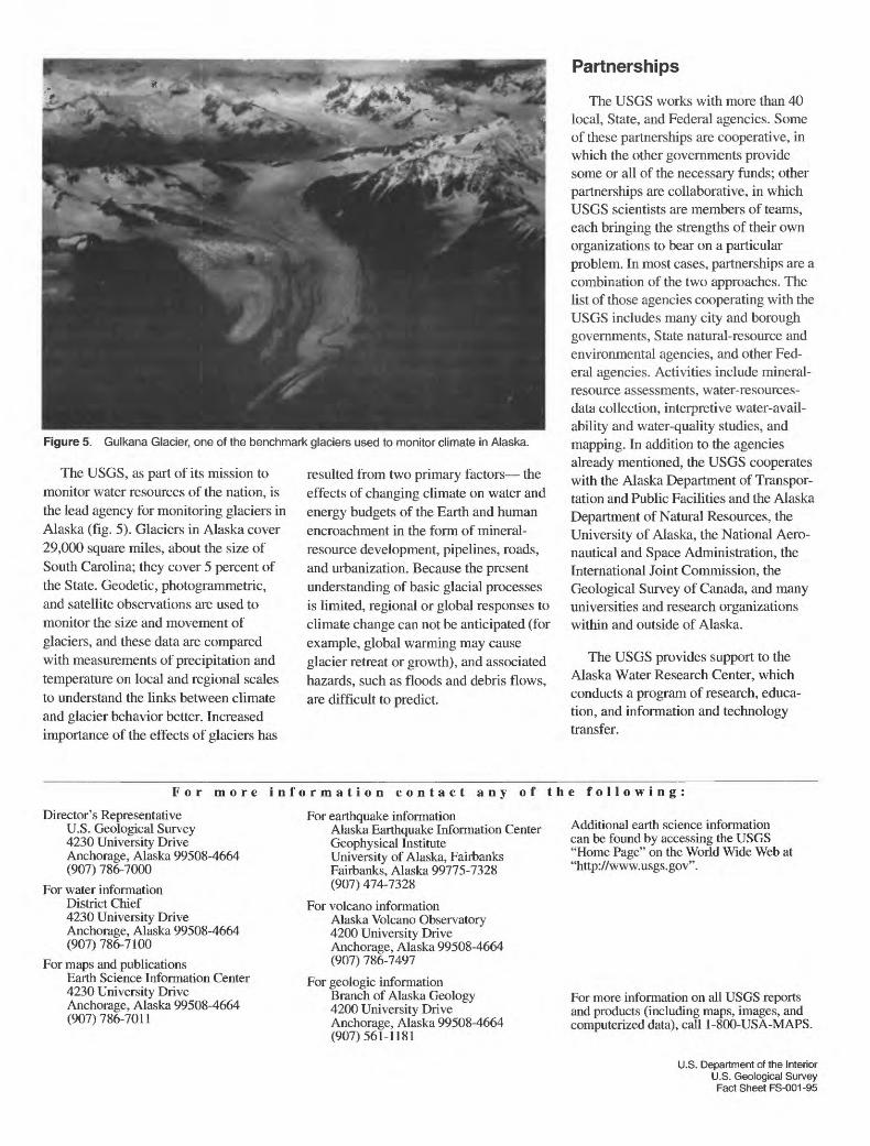
Figure 5. Gulkana Glacier, one of the benchmark glaciers used to monitor climate in Alaska.
The USGS, as part of its mission to monitor water resources of the nation, is the lead agency for monitoring glaciers in Alaska (fig. 5). Glaciers in Alaska cover 29,000 square miles, about the size of South Carolina; they cover 5 percent of the State. Geodetic, photogrammetric, and satellite observations are used to monitor the size and movement of glaciers, and these data are compared with measurements of precipitation and temperature on local and regional scales to understand the links between climate and glacier behavior better. Increased importance of the effects of glaciers has
resulted from two primary factors the effects of changing climate on water and energy budgets of the Earth and human encroachment in the form of mineral- resource development, pipelines, roads, and urbanization. Because the present understanding of basic glacial processes is limited, regional or global responses to climate change can not be anticipated (for example, global warming may cause glacier retreat or growth), and associated hazards, such as floods and debris flows, are difficult to predict.
Partnerships
The USGS works with more than 40 local, State, and Federal agencies. Some of these partnerships are cooperative, in which the other governments provide some or all of the necessary funds; other partnerships are collaborative, in which USGS scientists are members of teams, each bringing the strengths of their own organizations to bear on a particular problem. In most cases, partnerships are a combination of the two approaches. The list of those agencies cooperating with the USGS includes many city and borough governments, State natural-resource and environmental agencies, and other Fed eral agencies. Activities include mineral- resource assessments, water-resources- data collection, interpretive water-avail ability and water-quality studies, and mapping. In addition to the agencies already mentioned, the USGS cooperates with the Alaska Department of Transpor tation and Public Facilities and the Alaska Department of Natural Resources, the University of Alaska, the National Aero nautical and Space Administration, the International Joint Commission, the Geological Survey of Canada, and many universities and research organizations within and outside of Alaska.
The USGS provides support to the Alaska Water Research Center, which conducts a program of research, educa tion, and information and technology transfer.
For more information contact any of the following:
Director's Representative U.S. Geological Survey 4230 University Drive Anchorage, Alaska 99508-4664 (907) 786-7000
For water information District Chief 4230 University Drive Anchorage, Alaska 99508-4664 (907) 786-7100
For maps and publicationsEarth Science Information Center 4230 University Drive Anchorage, Alaska 99508-4664 (907)786-7011
For earthquake informationAlaska Earthquake Information Center Geophysical Institute University of Alaska, Fairbanks Fairbanks, Alaska 99775-7328 (907) 474-7328
For volcano informationAlaska Volcano Observatory 4200 University Drive Anchorage, Alaska 99508-4664 (907) 786-7497
For geologic informationBranch of Alaska Geology 4200 University Drive Anchorage, Alaska 99508-4664 (907) 561-1181
Additional earth science information can be found by accessing the USGS "Home Page" on the World Wide Web at "http://www.usgs.gov".
For more information on all USGS reports and products (including maps, images, and computerized data), call 1-800-USA-MAPS.
U.S. Department of the InteriorU.S. Geological SurveyFact Sheet FS-001-95


