Extent of Main Map - Network Rail … · Main Map General Map Notes: 1. Principal Network Rail...
1
Yeovil Salisbury Portsmouth Guildford Redhill Tonbridge Brighton Harwich Chester Llandudno Junction Selby Grangemouth Hillington (Deanside) Port of Garston Ditton Leeds Wakefield Selby Doncaster Hams Hall Ely March Hertford Watford Hitchin Colchester Stowmarket Newark Chesterfield Alfreton Kidsgrove Macclesfield Gainsborough Tamworth Leamington Spa Burton-on- Trent Melton Mowbray Worcester Wrexham Wigan Stockport Workington Oxenholme Penrith Wakefield Elderslie Teesport Darlington Castle Donington Staines Woking Willesden Jn Stratford Tilbury Felixstowe Port of Liverpool Port of Southampton London Gateway Barking Daventry Coatbridge Mossend Birch Coppice Trafford Park Lawley Street Ely York Hull Rugby Crewe LEEDS Derby Oxford Settle Ipswich Preston Norwich Bedford Swindon Swansea Coventry Hereford Nuneaton Dumfries Carlisle SHEFFIELD Bletchley Lancaster Doncaster Cambridge NEWCASTLE Gloucester Kings Lynn Felixstowe Shrewsbury Sunderland Northampton Basingstoke Peterborough Grimsby Dover Middlesbrough Wolverhampton Stoke-on-Trent Didcot Bury St Edmunds CARDIFF GLASGOW Exeter Newport Barrow-in-Furness Westbury Falkirk EDINBURGH Folkestone Berwick-upon-Tweed Southampton Warrington Stafford BRISTOL Bradford Ashford Carstairs Leicester Lockerbie Sleaford LONDON Lincoln Banbury LIVERPOOL MANCHESTER BIRMINGHAM Hexham Spalding NOTTINGHAM Grantham Eastleigh W10_CP4_End_CoreEK_25052012.mxd Extent of Main Map General Map Notes: 1. Principal Network Rail lines shown only. 2. Selected named Stations shown. 3. W10/12 data supplied by Ian Cleland, NR Freight Development Manager. 4. High Speed Lines not shown. 5. Original Map Scale 1:1,500,000 at A3 Size. 6. Map indicative only. Refer to the relevant Network Rail website and documentation (e.g. NESA) for business planning, safety or operational purposes. 0 5 10 15 20 Miles Selected Locations with Station Sea Port & Intermodal Rail Freight Terminal Intermodal Rail Freight Terminal Preston NOTTINGHAM Felixstowe Barking (other) (main city) Rail Network Network Rail Network Rail - W10/12 Loading Gauge W10 Loading Gauge at CP5 Start (June 2014) W10 expected to be delivered early in CP5 Proposed W10Gauge Route under development - outcome including date to be determined W10/12 "High Gauge" Network CP4 Period End (June 2014) OS information reproduced from the Ordnance Survey Map with permission of the Controller of Her Majesty's Stationery Office. Crown Copyright. License No. 0100040692. Tyne Reading S. Acton Tees Riverside Intermodal Park Wilton Bristol Wentloog
Transcript of Extent of Main Map - Network Rail … · Main Map General Map Notes: 1. Principal Network Rail...
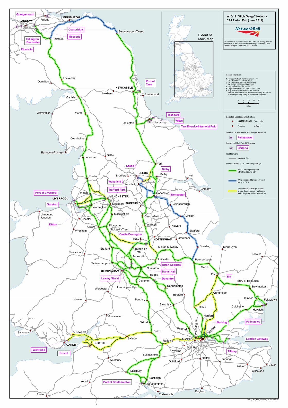
Yeovil
Salisbury
Portsmouth
GuildfordRedhill Tonbridge
Brighton
Harwich
ChesterLlandudnoJunction
Selby
Grangemouth
Hillington(Deanside)
Port of
Garston
Ditton
Leeds
Wakefield
Selby
Doncaster
Hams Hall
Ely
March
Hertford
Watford
Hitchin Colchester
Stowmarket
Newark
Chesterfield
AlfretonKidsgrove
Macclesfield
Gainsborough
Tamworth
Leamington Spa
Burton-on-Trent
Melton Mowbray
Worcester
Wrexham
Wigan
Stockport
Workington
Oxenholme
Penrith
Wakefield
Elderslie
Teesport
Darlington
Castle Donington
StainesWoking
Will
esde
n Jn
Stratfo
rd
Tilbury
Felixstowe
Port of Liverpool
Port of Southampton
London Gateway
Barking
Daventry
Coatbridge
Mossend
Birch Coppice
Trafford Park
Lawley StreetEly
York
Hull
Rugby
Crewe
LEEDS
Derby
Oxford
Settle
Ipswich
Preston
Norwich
Bedford
Swindon
Swansea
Coventry
Hereford
Nuneaton
Dumfries
Carlisle
SHEFFIELD
Bletchley
Lancaster
Doncaster
Cambridge
NEWCASTLE
Gloucester
Kings Lynn
Felixstowe
Shrewsbury
Sunderland
Northampton
Basingstoke
Peterborough
Grimsby
Dover
Middlesbrough
Wolverhampton
Stoke-on-Trent
Didcot
Bury St Edmunds
CARDIFF
GLASGOW
Exeter
Newport
Barrow-in-Furness
Westbury
FalkirkEDINBURGH
Folkestone
Berwick-upon-Tweed
Southampton
Warrington
Stafford
BRISTOL
Bradford
Ashford
Carstairs
Leicester
Lockerbie
Sleaford
LONDON
Lincoln
Banbury
LIVERPOOLMANCHESTER
BIRMINGHAM
Hexham
Spalding
NOTTINGHAM Grantham
Eastleigh
W10_CP4_End_CoreEK_25052012.mxd
Extent ofMain Map
General Map Notes:
1. Principal Network Rail lines shown only.2. Selected named Stations shown.3. W10/12 data supplied by Ian Cleland, NR Freight Development Manager.4. High Speed Lines not shown.5. Original Map Scale 1:1,500,000 at A3 Size.6. Map indicative only. Refer to the relevant Network Rail website and documentation (e.g. NESA) for business planning, safety or operational purposes.
0 5 10 15 20
Miles
Selected Locations with Station
Sea Port & Intermodal Rail Freight Terminal
Intermodal Rail Freight Terminal
Preston
NOTTINGHAM
Felixstowe
Barking
(other)
(main city)
Rail Network
Network Rail
Network Rail - W10/12 Loading Gauge
W10 Loading Gauge atCP5 Start (June 2014)
W10 expected to be delivered early in CP5
Proposed W10Gauge Route under development - outcomeincluding date to be determined
W10/12 "High Gauge" NetworkCP4 Period End (June 2014)
OS information reproduced from the Ordnance Survey Map withpermission of the Controller of Her Majesty's Stationery Office. Crown Copyright. License No. 0100040692.
Tyne
ReadingS. Acton
Tees Riverside Intermodal Park
Wilton
BristolWentloog