(Extent: 1.02.0Ha)-B2Project - … · II 50 25 8 119,121 13. ... The generation of the dust will be...
12
PROPOSAL TO OBTAIN ENVIRONMENTAL CLEARANCE FOR K.PITCHAMPATTI LIME STONE MINE (Extent: 1.02.0Ha)-B2Project IN S.F.Nos: 644/2 (P), 645/2 (P) Village: K.Pitchampatti Taluk: Karur District: Karur State: Tamilnadu SUBMITTED TO State Level Environment Impact Assessment Authority (SEIAA), Government of Tamilnadu Chennai. SUBMITTED BY A.V.Elamurugu (Proprietor, M/s. Mother Earth Minerals No.20-A, Koneripatti Extension II, Rasipuram – 637 408, Rasipuram Taluk, Namakkal District..
Transcript of (Extent: 1.02.0Ha)-B2Project - … · II 50 25 8 119,121 13. ... The generation of the dust will be...
PROPOSAL TO OBTAIN ENVIRONMENTAL CLEARANCE
FOR K.PITCHAMPATTI LIME STONE MINE
(Extent: 1.02.0Ha)-B2Project
IN
S.F.Nos: 644/2 (P), 645/2 (P)
Village: K.Pitchampatti
Taluk: Karur
District: Karur
State: Tamilnadu
SUBMITTED TO
State Level Environment Impact Assessment Authority (SEIAA),
Government of Tamilnadu
Chennai.
SUBMITTED BY
A.V.Elamurugu
(Proprietor, M/s. Mother Earth Minerals
No.20-A, Koneripatti Extension II,
Rasipuram – 637 408,
Rasipuram Taluk,
Namakkal District..
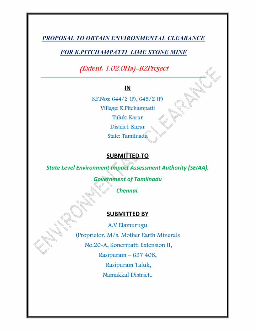
INDEX FILE
S.No Description Page
No’s
1 To Obtain Environmental Clearance 3
2 Environmental Clearance Format 5-9
3 Declaration Letter 11
4 Demand Draft 13
5 Form-1 15-51
6 Approved Scheme of Mining 53-325
7 Pre-Feasibility Report 327-381
8 VAO signed for Quarry site 383
9 Baselines Studies 385-407
10 Affidavit Document 409-411
11 Details of Quarries 413
12 Habitation details from VAO 415
13 Copy of Explosive License 417-419
14 Consolidated above Document in
PDF Format (CD)
421

To consider the proposal for the grant of Environmental Clearance for Limestone mining in 1.02.0Ha in
S.F.Nos: 644/2 (P), 645/2 (P)of K.Pitchampatti Village in Karur Taluk,Karur District by A.V.Elamurugu,
(Proprietor, M/s. Mother Earth Minerals).
The salient features of the proposal are as follows:
S.No: Details of the proposal : Data furnished Page No:
1.
Name of the owner/Firm
:
A.V.Elamurugu
(Proprietor, M/s. Mother Earth Minerals),
No.20-A, Koneripatti Extension II,
Rasipuram – 637 408,
Rasipuram Taluk,
Namakkal District.
3,17,53,57,
,85,93,327,
2.
Type of quarrying
(Savudu/Rough stone/
Sand/Granite/ Limestone)
:
It is a Limestone Mining project in K.Pitchampatti
village.
3,17,53,57,
,85,93,327,
3. S.F.No of the quarry site with
area break up :
644/2 (P), 645/2 (P) 3,17,53,57,
,85,93,327,
4. Village in which situated
: K.Pitchampatti Village 3,17,53,57,
,85,93,327,
5. Taluk in which situated
: Karur Taluk 3,17,53,57,
,85,93,327,
6. District in which situated
: Karur District 3,17,53,57,
,85,93,327,
7. Extent of quarry (in ha)
1.02.0Ha 3,17,53,57,
,85,93,327,
8.
Period of mining proposed
:
Mining lease period is thirty years (14.09.1998 to
13.09.2018).
Mining plan period = 1998-99 to 2002-03
1st Scheme of Mining period = 2009-10 to 2013-14
2nd
Scheme of Mining period = 2013-14 to 2018-19
83,223,289
,329,
9.
Production (Quantity in Ts)
:
The proposed quantity of Limestone 8,845Ts (70%
Limestone) and 3,791Ts (30% of Mineral Reject) for
the remaining scheme periods.
17,347
10. Latitude and Longitude of all
corners of the quarry site : N 10
048’10’’
E 780 05’ 03’’
17,343
11. Topo sheet No : 58-J/01 17,343
12. G.O.No : G.O. (3D). No. 215 Industries (MMA2) Department,
dated 16.12.1997.
83,223,289
,329,
13. Mining plan approved by the
IBM,RCOM :
TN/TNL/MP/LST/895-MDS, dated 11.01.96 55,
14.
Water Requirement:
1. Drinking & Domestic
purpose (in KLD)
2. Dust suppression & Green
Belt (in KLD)
;
Purpose Quantity
KLD
Source
Drinking 0.2KLD Water vendors
Domestic purpose 0.4KLD From Existing bore hole on
nearby mine
Dust suppression
and Afforestation
0.4KLD From Existing bore hole on
nearby mine
31.355
15. Depth of mining : The depth of the mining is 7 m below the ground level. 93,103
16.
Project cost (including EMP
cost) :
The total project cost including EMP cost (A+B+C) is
about Rs. 32,33,875/- (Rupees thirty two lakhs and
thirty three thouosands eight hundered five only).
283,331
17. EMP cost
: The total EMP cost is about Rs. 3,97,500/- (Rupees
three lakhs ninety seven thousand and five hundred).
283,331

Checklist for Mining of Limestone 1.02.0 Ha mine lease area
S.No Details of the proposal : Data furnished Page No
1. Name of the owner/Firm
: A.V.Elamurugu
(Proprietor, M/s. Mother Earth Minerals),
3,17,53,5
7,,85,93,3
27,
2.
Correspondence Address with Pin
Code :
No.20-A, Koneripatti Extension II,
Rasipuram – 637 408,
Rasipuram Taluk,
Namakkal District.
3. Email Address : [email protected] 17,
4. Mobile Number : 94432 47673 17,
5.
Type of quarrying
(Earth/ Rough stone/Sand/Granite/
Limestone)
:
It is a Limestone Mine Project in K.Pitchmpatti Village. 3,17,53,5
7,,85,93,3
27,
6.
S.F. No of the mine site
:
644/2 (P), 645/2 (P) 3,17,53,5
7,,85,93,3
27,
7.
Village in which situated, Town
Panchayat/ Panchayat Union in
which the village is situated
:
Village Panchayat: K.Pitchampatti
Panchayat Union :Karur
3,17,53,5
7,,85,93,3
27,
8.
Taluk in which situated
:
Karur Taluk 3,17,53,5
7,,85,93,3
27,
9.
District in which situated
:
Karur District 3,17,53,5
7,,85,93,3
27,
10.
Extent of mine (in Ha)
:
1.02.0Ha 3,17,53,5
7,,85,93,3
27,
11.
New or existing mine
:
It is an existing Limestone Mine Project of K.Pitchampatti
Village.
3,17,53,5
7,,85,93,3
27,
12.
If in case of existing Rough Stone/
Blue Metal/ Granite/ Limestone
mine, the length, width and depth to
which quarrying has already been
done (below the ground level/ above
the ground level)
:
Pit L (m) W(m) D(m) Max
I 43 20 2
II 50 25 8
119,121
13.
If mining had been done below the
ground level/above the Ground level,
the height of mining
: If the mining had been done maximum 18m 119
14.
Name of the owner who had earlier
undertaken the mining& a copy of
mining lease issued with date
:
It is an existing Limestone Mine Project of K.Pitchampatti
Village.
3,17,53,
15.
Proof of land ownership.
If owned patta copy.
If not own patta land agreement/
lease copy entered with the owner
(to be enclosed)
:
It is a patta land, owned by the Rajeswari, the applicant
obtained consent from the pattadhars.
85,333,
16. Period of mining
: Mining lease period is Twenty years (14.09.1998 to
13.09.2018).
83,223,28
9,329,
The scheme of mining plan is prepared for a period of five
years (98-99 to 2002-03).
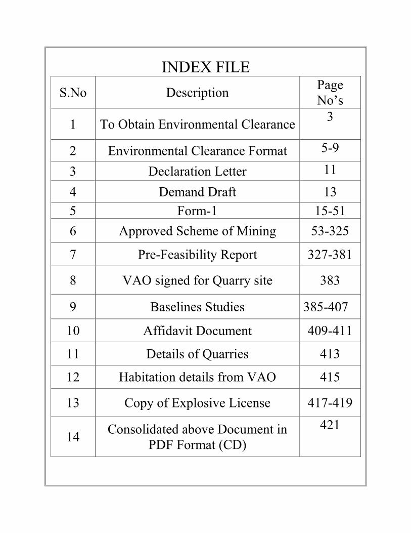
17.
Production (quantity in Ts)
Description
ROM (Ts)
Limestone
@ 70%
(Ts) of
ROM
Mineral
Rejects
(30%) Ts of
ROM
Side
burden
(TS)
Top
soil
(Ts)
Total waste
(30%
Mineral +
SB)
Geological
Resources 284851 199396 73155 5023 95630 19314
Mineable
Reserves 71427 49999 21428
Year wise
Reserves 21216 14851 6365 3276 1888 9641
99,161,33
1
18.
Method of Mining
:
One bench is proposed on the topsoil with 1m height and
width with 45o slope.
In mineral, two benches are proposed with 3m height & 5m
width slope maintained as 60o from horizontal in North,
East, West and Southern Side of the lease area and one
bench is proposed with 3m height & 5m width..
155,331,3
51
19. Top soil/ Overburden in case of
Rough Stone/ Blue Metal : The average depth of top soil is about 1m depth. 1,276Ts of
top soil proposed for the remaining scheme periods.
125,141,3
31,359
20. Quantity of rejects in Ts in case of
LimestoneMining. : Mineral rejects are generated in the scheme periods would
be 3,791 Ts (Remaining 2016-17 to 2018-19).
83,223,28
9,329,
21.
Length, Width, Depth & Proposed
mine in meters.
:
Dimension of the year wise: Length (m) Width (m) Depth (m)
75 (max) 38 (max) 7
Ultimate pit dimensions
Dimen
sions
Present size of pit
Ultimate pit
dimensions at the end
of present scheme
period
Ultimate pit
dimensions
at the end
of life of the
mine Pit-1 Pit-2
Pit-1 Pit-2
Length
(m) 43 50 75 50 152
Width
(m) 20 25 35 25 35
Depth
(m) 2 18 7 18 18
119,121
22.
Land use pattern for a radius of 1Km
around the mine site such as
Agriculture, Habitation etc., :
Road– 06%
Habitation – 13%
Trees – 03%
Agricultural Land – 58%
Barren Land –20%
327

23.
Details of other mining for a radius
of 1Km, around the quarry site. :
The village Topo sketch map showing the quarry proposed
site.
There is no mine within the radius of 500m.
327
24. Aerial distance from periphery of the
site to the nearest habitation : The Nearest habitation K.Pitchmapatti is 1km on Southern
side.
47,327
25.
Aerial distance to the interstate
borders, in case of Rough Stone/
Blue Metal/ Granite/Limestone mine
to be obtained from IRS, Anna
University.
:
There is no interstate boundary within the radius of 15km. 47,333
26.
In case of Rough Stone/ Blue Metal/
Granite/Limestone mine no objection
certificate from the concerned
district Forest Officer/ Wild Life
Sanctuaries/ National Parks/ HACA/
Western Ghats region if the quarry
site is within 15 Kms of these areas.
:
There are no wild life sanctuaries, National parks, HACA,
Western Ghats region within the radius of 15km.
47,333
27.
Aerial distance to the nearest eco-
sensitive areas, CRZ, Forests,
Monuments etc., within 15Kms of
these areas.
:
There is no CRZ, Monuments, forest and sensitive areas
within the radius of 15km.
47,333
28. Latitude and Longitude of all corners
of the mine site. : N 10
048’10’’
E 780 05’ 03’’
17,343
29. Topo Sheet No : 58-J/01 255,295,
30.
Copy of explosives license and a
consent letter/ agreement of
competent recognized person who
has agreed to handle explosive for
the blasting, in case of Rough Stone/
Blue Metal/ Granite/ Limestone
mine.
:
A copy of consent letter and license copy enclosed.
371-377
31.
Brief details of APC measures
proposed to be proposed to be
implemented.
:
The generation of the dust will be suppressed by means of
water sprinkler immediately by mechanical means. The
generation of dust during the course of drilling will be
suppressed at source by means of wet drilling or dust
extractors. The periodical environmental monitoring test is
been proposed to carry out by accredited laboratories. The
change in air quality will be minimal well within the
prescribed limits.
155
32.
Mine Closure Plan to be furnished in
Scheme of Mining.
:
During the end of the life of the mine, when the mine
reaches its ultimate pit limit, the pit will be partially
backfilled and partially act as a good storage for water. The
spring water and seepage water will prove to be a viable
source for water supply to agriculture lands nearby.
Along the permanent roads and vacant places,
afforestation is being carried out present. Before closure of
the mine, a parapet wall will be constructed to prevent
inadvertent entry of cattle and human beings.
The dumps will be vegetated to prevent slitting and
157

always maintained at 45-degree slope.
33. Mining plan prepared by (Xerox
copy of certificate to be attached) :
Dr.P.Thangaraju, M.Sc.,Ph.D.,
RQP/MAS/206/2007/A.
87,
34. Precise area communication
approved by the District Collector : G.O. (3D). No. 215 Industries (MMA2) Department, dated
16.12.1997.
227,
35.
Mining plan approved by the
Deputy/ Assistant Director of the
District. :
The Mining plan was approved by the Regional Controller
of Mines, Indian Bureau of Mines, Chennai vide Letter.
No: TN/TNL/MP/LST/895-MDS, dated 11.01.96.
55,
36.
Water requirement :
a) Drinking & domestic
purposes in KLD.
b) Dust suppression (in KLD)
c) Green belt (in KLD)
:
Drinking Water - 0.2 KLD
& Domestic purpose
Dust Suppression - 0.4 KLD
Green belt -0.4 KLD
Total -1.0 KLD
33,309,32
7,
37.
Source of water
:
Purpose Sources
Drinking &
Domestic
Purpose
Packaged drinking water is available from
the nearby approved water vendors
Dust suppression From Existing Borehole on nearby mine
Green belt
development
From Existing Borehole on nearby mine
33,309,32
7,
38. Ground water table : The Ground water is about 38mt depth from ground level. 99,
39.
Project Cost including EMP Cost)
:
A. Fixed asset cost = Rs. 4,04,000/-
B. Project cost = Rs. 24,32,375/-
C. EMP cost = Rs. 3,97,500/-
Total cost = Rs. 32,33,800/-
283,331
40. EMP Cost : The total EMP cost is about Rs. 3,97,500/- 283,331
41. Disclosure RQP
:
Dr.P.Thangaraju, M.Sc.,Ph.D.,
RQP/MAS/206/2007/A.
87,
42.
Soft copy of the Form–1,
Pre –feasibility report and Mining
plan in CD.
:
There is enclosed Soft copy for form–1, Pre– feasibility
report and mining plan in CD.
251
43.
Key map showing the approach
roads to the site to be attested by the
Deputy/ Assistant Director of
Geology and Mining of the
concerned District.
:
The Route map showing with approach roads to the site is
enclosed Plate No: IA
257
44.
Village map with S.F. Nos& salient
features such as vegetation,
habitations etc., for a radius of 500m
around the mine site.
:
Village map with S.F.No and Salient features such as
vegetation, habitation etc., for 500mt radius is enclosed as
Plate no. VIII
273
45.
If lakes, Ponds, river, nallah, odai
etc. are situated near the mine site
permission from the concerned PWD
authorities for mining
There is no Rivers/Stream, Lakes, and Reservoir within the
500m distance to the lease applied area.
Amaravathi river is passing 17km away from the Northern
side of the area.
283,319,
46.
Section map for mining to be
attested by the Deputy/ Assistant
Director of Geology and Mining of
the concerned District.
:
The Geological Plan and section in 1:1000 & 1:500 scale is
enclosed: IV.
265

47.
Photograph of the proposed Mining
site with S.F.No and attested by at
least VAO.
:
The Photo of the mining site is enclosed. 317
48. Form –I To be signed by applicant : I am hereby signed 53
49. Pre- Feasibility Report to be signed
by applicant. :
Pre-feasibility report has been signed by the applicant
335
50.
First and last page and the page at
which quantity of mining has been
worked out to be signed by the
Deputy/Assistant Director of
Geology and Mining of the
concerned District.
:
First page and last page and the quantity proposed in the
plan have been signed by the Commissioner of Geology
and Mining.
79,177
51.
Affidavit from the applicant that
child labor is not being employed in
the mining activity. :
It is been ensured that the labor will not be employed less
than 18 years, No child labor will engaged or entertained
for any kind of mining operations. All the labor engaged
for mining operations will be insured during the mine lease
period.
363,365
52.
Affidavit from the applicant
regarding planting of trees around
the quarry site in fulfillment of the
Green belt commitment furnished.
:
Affidavit from the applicant regarding the proposal for
planting trees around the mining and fulfillment of
greenbelt commitment is enclosed
363,365
53.
Details (POD) Regarding
communicating the proposal to the
members of the committee.
:
1. Signature of the applicant
A.V.Elamurugu
(Proprietor, M/s. Mother Earth Minerals)
2. Signature of the Recognized qualified person
Dr. P. Thangaraju M.Sc., Ph.D.,
RQP /MAS/206/2007/A
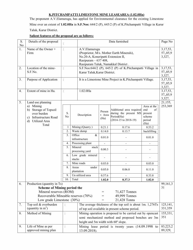
K.PITCHAMPATTI LIMESTONE MINE LEASEAREA (1.02.0Ha)
The proponent A.V.Elamurugu, has applied for Environmental clearance for the existing Limestone
Mine over an extent of 1.02.0Ha in S.F.Nos: 644/2 (P), 645/2 (P) of K.Pitchampatti Village in Karur
Taluk, Karur District.
Salient features of the proposal are as follows:
S.
No
Details of the proposal :
Data furnished Page No
1. Name of the Owner +
Firm
: A.V.Elamurugu
(Proprietor, M/s. Mother Earth Minerals),
No.20-A, Koneripatti Extension II, Rasipuram – 637 408,
Rasipuram Taluk, Namakkal District .
3,17,53,
57,,85,9
3,327,
2. Location of the mine-
S.F.No.
: S.F.Nos:644/2 (P), 645/2 (P) of K.Pitchampatti Village in
Karur Taluk,Karur District.
3,17,53,
57,,85,9
3,327,
3. Purpose of Application : It is a Limestone Mine Project in K.Pitchampatti Village. 3,17,53,
57,,85,9
3,327,
4. Extent of mine in Ha. : 1.02.0Ha 3,17,53,
57,,85,9
3,327,
5. Land use planning
a) Mining
b) Storage of Topsoil
over burden
c) Infrastructure Road d) Utilized Area
Total
S.
No Description
Presen
t Area
(Ha)
Additional area required
during the present MS
Period(Ha)
(2014-15 to 2018-19)
Area at the
end of
present
scheme
period
(Ha)
1 Mining (Quarry ) 0.21.1 0.17.6 0.53.2
2. Waste dump 0.14.0 0.13.7 backfilling
3. Office &
infrastructure 0.01.0 - 0.01.0
4. Processing plant - - -
5. Mineral stack
processing yard 0.00.3 - -
6. Low grade mineral
stacks - - -
7. Mine roads 0.03.0 - 0.03.0
8. Areas under
plantation 0.05.0 0.06.0 0.11.0
9. Un utilized area 0.57.6 - 0.33.8
10. Total 1.02.0 0.37.3 1.02.0
21,155,
253,369
6. Production (quantity in Ts)
Scheme of Mining period the
Mineral reserves (ROM) = 71,427 Tonnes
Recoverable Mineable reserves (70%) = 49,999 Tonnes
Low grade Limestone (30%) = 21,428 Tonns
99,161,3
31
7. Top soil & overburden (quantity in m3)
: The average thickness of the top soil is about 1m. 1,276Ts
of top soil available in present scheme period.
125,141,331,359
8. Method of Mining : Mining operation is proposed to be carried out by opencast
semi mechanized method and proposed benches are 3m
height and 5m width with 60º slope.
155,331,
351
9. Life of Mine as per
approved mining plan
: Mining lease period is twenty years (14.09.1998 to
13.09.2018).
83,223,2
89,329,

10. Height / width of the bench
: In Topsoil - 1m Height. In Mineral
Height 3.0m & Width 5.0m
155,331,351
11. Source of water / quantity
required
:
Quantity
required
(in litres)
Source
31.355
a. Drinking&Domestic
Purpose
0.3 KLD Packaged drinking water is available from the approved
water vender
b. Dust Suppression 0.3KLD From Existing bore hole on nearby mine
C. Afforestation 0.4 KLD From Existing bore hole on nearby mine
12. Waste water
Sewage water
Mode of disposal
:
:
There is no waste water. 37,
The septic tank is constructed on permanent structure with
in the mine lease area.
To local Panchyat Authority
13. APC Measures : 1.Mist Spray using water tankers,
2. Enclosed covered system. (Tarpaulin) for transportation.
37,
14. Ariel distance of nearest
habitation
:
S.
No Name of the Village
Approximate Distance &
Direction from lease area
Approximate
population
1. P.Kullampatti 1.0km-NE 400
2. K.Pitchampatti 1.0km – SE 1000
3. MustakinathuPatti 4.0Km-NW 1000
4. Vasanthakathirapalayam 4.0km- SE 1200
47,367,
15. Ariel distance from
Reserve forest, Sensitive
areas, Forest, Bird
sanctuaries, Wild life
sanctuaries, National
parks, Monuments etc.,
within 15km
: Bird Sanctuaries – Nil
Wild life sanctuaries - Nil
National Park – Nil
Monuments – Nil
Reserve forest –Nil
47,333
16. Land owner ship document
Own patta land
Lease Govt. Poromboke
:
:
:
It is Patta land registered in the name of proponent, hence the proponent has surface right over the area.
85,333,
17. Land use classification : It is an existing Limestone Mine Project of K.Pitchampatti Village.
3,17,53,57,,85,9
3,327,
18. Mining plan prepared by
:
Dr.P.Thangaraju, M.Sc.,Ph.D.,
RQP/MAS/206/2007/A
87,
19. Approved by : The Mining plan was approved by the Regional Controller
of Mines, Indian Bureau of Mines, Chennai vide Letter. No:
TN/TNL/MP/LST/895-MDS, dated 11.01.96
83,223,2
89,329,
20 Precise area statement
Approved by
: The Mining lease was granted vide G.O. (3D). No. 215
Industries (MMA2) Department, dated 16.12.1997. 83,223,2
89,329,
21. Nearby quarries : There is no mine within 500m radius lease area. 365
22. Nearby lake / river/ odai /
channel etc.
: There is no Rivers/Stream, Lakes, and Reservoir within the
500m distance to the lease applied area.
Amaravathi river is passing 17km away from the north-western side of the area.
47,333
23. Latitude / Longitude : N 10048’10’’
E 780 05’ 03’’
17,343
24. GI Sheet No. : 58 – J/01 17,343

25. Project Cost(Project cost +EMP cost)
: A. Fixed asset cost = Rs. 4,04,000/-
B. Project cost = Rs. 24,32,375/-
C. EMP cost = Rs. 3,97,500/-
Total cost = Rs. 32,33,800/-
333,371
26. EMP Cost (Capital and
recurring)
: The total EMP cost is about Rs. 3,97,500/- 333,371
27. Water table : The Ground water is about 38mt depth from ground level. 97,
28. Interstate boundary : There is no interstate boundary within the radius of 15km. 47,333
29. Western Ghats : There is no Western Ghats within the radius of 15km. 47,333

From:
A.V.Elamurugu
(Proprietor, M/s. Mother Earth Minerals),
No.20-A, Koneripatti Extension II,
Rasipuram – 637 408,
Rasipuram Taluk,
Namakkal District.
To:
THE CHAIRMAN,
STATE LEVEL ENVIRONMENT IMPACT ASSESSMENT AUTHORITY,
PANAGAL BUILDING, SAIDAPET,
CHENNAI
Sir,
Sub: Submission of Form–1, Pre-feasibility report and Scheme of Mining (Ref. Scheme of
Mining Letter. No: TN/KRR//LST/MS-1124.MDS, dated 05.11.2014.) for obtaining
Environmental Clearance for our K.Pitchampatti Limestone mine Lease area- Reg.,
****************
I am here by submitting the processing fee in the form of demand draft for rupees ten thousand,
along with Form-1, Pre-feasibility report and scheme of mining plan to your good office for obtaining
clearance from SEIAA, Chennai, for our K.Pitchampatti Limestone mine Lease area for over an extent of
1.02.0Hain S.F.Nos. 644/2 (P), 645/2 (P) of K.Pitchampatti Village, Karur Taluk and Karur District,
Tamilnadu.
I have submitted all the relevant documents to your good office to the best of our knowledge. If
any clarifications are required, we are ready to submit the same to your office at your convenient time.
Also we are ready to present the project in front of the committee.
Hence we request your good office to kindly process our application and allow us to present our
project at the earliest.
Thanking you.
Yours sincerely
A.V.Elamurugu,
For
M/s. Mother Earth Minerals.
Place: Namakkal
Dated: