EXTENSION TO EXISTING CLASS 1A DWELLING
31
Page 1 | 27 BUSH FIRE RISK ASSESSMENT REPORT EXTENSION TO EXISTING CLASS 1A DWELLING 2460 PALANA ROAD - LUGHRATA 26 TH JUNE 2020 Disclaimer: The information in this report is ensuring compliance with the Flinders Planning Scheme 1994 – Amended June 2013, and consistent with, the Director’s Determination 16 th March 2020 – Requirements for Building in Bushfire-Prone Areas (transitional), Building Act 2000 & Building Regulations 2014 that remain in force by virtue of clause 3(2) of Schedule 6 of the Building Regulations 2016. The information stated within this report is also based on the instructions of AS 3959 – 20018 – Construction of buildings in bush fire-prone areas. The purpose of this code is to ensure that use and development is appropriately designed, located, serviced, and constructed, to reduce the risk to human life and property, and the cost to the community, caused by bushfires. “It should be borne in mind that the measures contained in this Standard cannot guarantee that a building will survive a bushfire event on every occasion. This is substantially due to the degree of vegetation management, the unpredictable nature and behaviour of fire, and extreme weather conditions”. GPM P/L has taken all reasonable steps to ensure that the information and data collected in the preparation of this assessment is accurate and reflects the conditions on and adjoining the site and allotment on the date of assessment. GPM P/L do not warrant or represent that the information contained within this assessment report is free from errors or omissions and accepts no responsibility for any loss, damage, cost or expense (direct or indirect) incurred as result of a person taking action in respect to any representation, statement or advice referred to in this report. This report is only to be used for the purpose of which it was commissioned. Document Version: 01 – 26 th June 2020
Transcript of EXTENSION TO EXISTING CLASS 1A DWELLING

P a g e 1 | 27
BUSH FIRE RISK ASSESSMENT REPORT
EXTENSION TO EXISTING CLASS 1A DWELLING
2460 PALANA ROAD - LUGHRATA
26TH JUNE 2020
Disclaimer: The information in this report is ensuring compliance with the Flinders Planning Scheme 1994 – Amended June 2013, and
consistent with, the Director’s Determination 16th March 2020 – Requirements for Building in Bushfire-Prone Areas (transitional), Building Act
2000 & Building Regulations 2014 that remain in force by virtue of clause 3(2) of Schedule 6 of the Building Regulations 2016. The information
stated within this report is also based on the instructions of AS 3959 – 20018 – Construction of buildings in bush fire-prone areas. The purpose
of this code is to ensure that use and development is appropriately designed, located, serviced, and constructed, to reduce the risk to human
life and property, and the cost to the community, caused by bushfires.
“It should be borne in mind that the measures contained in this Standard cannot guarantee that a building will survive a bushfire event on
every occasion. This is substantially due to the degree of vegetation management, the unpredictable nature and behaviour of fire, and extreme
weather conditions”.
GPM P/L has taken all reasonable steps to ensure that the information and data collected in the preparation of this assessment is accurate
and reflects the conditions on and adjoining the site and allotment on the date of assessment. GPM P/L do not warrant or represent that the
information contained within this assessment report is free from errors or omissions and accepts no responsibility for any loss, damage, cost
or expense (direct or indirect) incurred as result of a person taking action in respect to any representation, statement or advice referred to in
this report. This report is only to be used for the purpose of which it was commissioned.
Document Version: 01 – 26th June 2020
P a g e 2 | 27
CONTENTS
Executive Summary 3
Introduction 4
Description of Proposal 5
Bushfire Site Assessment 6
Other Considerations 13
Conclusions / Recommendations 14
Report Preparation & Certification 15
Definitions 16
References 17
Appendixes
- Title Plan 18
- Site Plan 19
- Floor Plans 20
- Elevation Plans 21
- Aerial View of Allotment 22
- TasVeg 3.0 Map 22
- Natural & Cultural Values Map 23
- Photo of Development Site 23
- Photos of Surrounding Vegetation 24
- Accreditation Documentation 26
- Copy of Insurances 27
Bushfire Hazard Management Plan (BHMP) Map
Form 55

P a g e 3 | 27
EXECUTIVE SUMMARY
The proposed development is a 2-storey extension to an existing Class 1A Dwelling. The allotment site is located
in Lughrata, a small community on the western side of Flinders Island, approximately 20km north, northwest of
Whitemark. The development site is in a coastal forested area that borders varying sized private allotments with
similar vegetation types to the West, South and East and the North. Some larger areas of consolidated agricultural
grassland exist to the east, south east of the allotment. Areas of managed ground exist around the existing
dwelling and associated infrastructure.
Assessment of the allotment has concluded that there is a risk of bushfire associated with the development due
to the location of the bushfire prone woodland community that exists to the north, east and south and the
grassland community that exists to the west, within 100m of the proposal.
The proposed development is located within an area of Rural Zoning. The lot size is ±99ha.
Using ASA3959 – 2018 Simplified procedure (Method 1), the Bushfire Attack Level of the site and the associated
extension construction requirements will be classified as BAL 12.5. BAL – 12.5 is described as being exposed to
“Ember attack and radiant heat below 12.5 kW/m²”.
The BAL classification provided provides specifications for construction standards and the determination of the
hazard management area defined in the Bushfire Hazard Management Plan (BHMP). A BAL 12.5 solution has been
designated as there is ample room for clearing or maintenance of vegetation to achieve the required hazard
management area.
The development does not require the clearing of vegetation from neighbouring properties as acceptable
distances for the proposed hazard management area can be met within the property boundaries.
The Bushfire Attack Level (BAL) Report and Bushfire Hazard Management Plan (BHMP) has been prepared under
the Building Act 2000 & Building Regulations 2014 that remain in force by virtue of clause 3(2) of Schedule 6 of
the Building Regulations 2016 and the requirements of Planning Directive No. 5.1 Bushfire-Prone Areas Code,
September 01st 2017.

P a g e 4 | 27
INTRODUCTION
Client: Glenn Sandford.
Development Type / BCA Classification: Class 1A Dwelling Extension.
Dwelling Floor Plan: As per attachment.
Area Schedule:
Construction Materials:
• Will be required to achieve BAL 12.5 rating standard.
• As per elevation drawings.
Date of Site Inspection: 24/06/2020
Inspected by: Justin Cashion – Ground Proof Mapping P/L
This proposal will ensure that “use and development is appropriately designed, located, serviced and constructed,
to reduce the risk to human life and property, and the cost to the community, caused by bushfires”.
This Bushfire Risk assessment report will define the sites Bushfire Attack Level classification and determine its
compliance with the requirements of the National Construction Code (NCC), 2019 and AS3959 – 2009
Construction of Buildings in Bushfire Prone Areas 2018.
This report will satisfy associated Council Building Requirements.

P a g e 5 | 27
DESCRIPTION OF PROPOSAL
Proposal: Class 1A Dwelling Extension
Applicants Name: Glenn Sandford
Location: 2460 Palana Road – Lughrata – Flinders Island
Property ID: 6424488
Title Reference: 207905/1
Lot Size: ±99ha
Zoning: Rural
Special Areas Overlay: Nothing identified
Council: Flinders
Defendable Space – Maintain the vegetation in a “low fuel” state within the required distance set out in this report
(as shown on the Bushfire Hazard Management Plan) to satisfy ongoing compliance.
Access – Existing access is onto Palana Road (Council maintained street/road). No further requirements to satisfy
access and egress as outlined further in this report.
Water Supply – Existing satisfactory firefighting water supply. No further requirements to satisfy water supply as
outlined further in this report.
Construction – Construct and maintain the proposed dwelling to a minimum specification complying with BAL –
12.5 in accordance with AS3959 2018, Sections 3 and 5.
Surrounding Area - The development site is surrounded by woodland and agricultural grassland.
Predominant Fire Direction – The predominant fire direction during the summer period is from the North and
North West, however as the location is on Flinders Island, it is subject to varying winds and sea breezes. The
vegetation that triggers the assessment provides a realistic fire threat under any fire weather conditions.

P a g e 6 | 27
BUSHFIRE SITE ASSESSMENT
Vegetation
Vegetation within 100m of the site of development is predominantly Allocasuarina verticillata forest (NAV), which
has a bushfire classification of woodland. This vegetation type exists to the north, east and south. Agricultural
grassland (FAG) exists to the west. Some further minor clearing of vegetation is required on the eastern and south
eastern boundaries of the HMA for compliance. Once completed, the ongoing maintenance of this hazard
management area should continue in perpetuity. The maintenance management requirements are specified
further in this report.
Slope / Aspect
The slope class across the development site is in the 0 - 5° range, whilst the surrounding areas within 100m of the
development are also within the 0 - 5° range. The aspect is predominantly westerly. The altitude for the proposed
dwelling extension is at ±40m.
Distances to Vegetation
Appropriate distances to assessable flammable vegetation from the all façades, allows for the construction
standards for the dwelling extension to be classified within those required for a BAL rating of 12.5, if proposed
hazard management areas are maintained in perpetuity. The required HMA for BAL 19 rating is shown on the
attached BHMP map. A purple line delineated on the attached BHMP map shows the extent of the assessment
area (e.g. all vegetation with 100m of each façade of the proposed dwelling extension).
Assessment and HMA
The proposed development is located in a forested interface and the risk of bushfire attack is considered to be a
realistic threat. Using AS3959-2018 Simplified Procedure (Method 1) the Bushfire Attack Level of the site and the
associated construction requirements will be classified as BAL – 12.5.
Bushfire Attack Level (BAL) – Steps 1 to 5 Summary Results
For calculations based on Tasmania’s FDI of 50, please refer to Table 1 below:
North
East
South
West
Vegetation to
100m Woodland Woodland Woodland Grassland
Vegetation
Classification B B B G(i)
Slope Level/Upslope Level/Upslope Downslope
0 - 5° Downslope
0 - 5°
Current BAL BAL 12.5 BAL 19 BAL 12.5 BAL 12.5
Proposed BAL BAL 12.5 BAL 12.5 BAL 12.5 BAL 12.5
HMA for BAL
12.5 22m 22m 26m 16m
*2.2.3.2:
(e) Exclusions – Non-vegetated areas, including waterways, roads, footpaths, buildings and rocky outcrops.
(f) Exclusions—Low threat vegetation, including grassland managed in a minimal fuel condition, maintained lawns, golf courses, maintained
public reserves and parklands, vineyards, orchards, cultivated gardens, commercial nurseries, nature strips and windbreaks.

P a g e 7 | 27
HMA Requirements
As per Director’s Determination – Requirements for Building in Bushfire-Prone Area, Table 4 Requirements for
Hazard Management Area:
Element C: Hazard management areas for alterations or additions to buildings.
Requirement: An alteration or addition to a building must:
(a) be located on the lot so as to be provided with a HMA which:
(i) has the separation distances required for the BAL assessed for the construction of the existing
building; or
(ii) in the case of a building without an existing BAL assessment, is no smaller than the separation
distances required for BAL 29; and
(b) have a HMA established in accordance with a certified bushfire hazard management plan.
HMA Guidelines
The HMA requirements listed in Table 1 are the minimum distances required to achieve a compliance rating of
BAL – 12.5. The HMA (defendable space area), should have significant fuel reduction carried out to ensure
compliance with low threat vegetation classification. This single zone hazard management area must be managed
and kept in a minimum fuel condition at all times “where fine fuels are minimised to the extent that the passage
of fire will be restricted, e.g. short green lawns, paths, driveways etc.”. All grassed areas within this zone need to
be short cropped and kept to a nominal height of 100mm.
The four design principles for this area are to:
(1) Create space
(2) Remove flammable objects or materials
(3) Separate fuel
(4) Selection, location and maintenance of trees
The diagram below explains this requirement.
P a g e 8 | 27
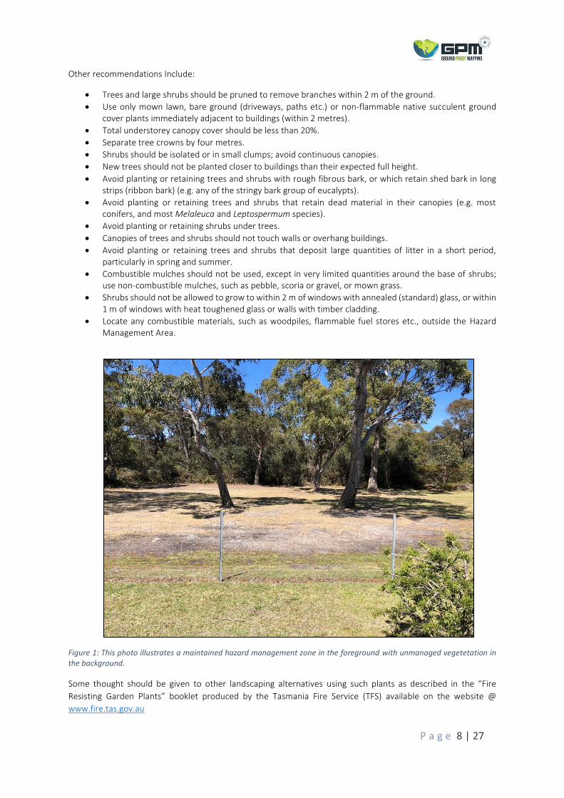
Other recommendations Include:
• Trees and large shrubs should be pruned to remove branches within 2 m of the ground.
• Use only mown lawn, bare ground (driveways, paths etc.) or non-flammable native succulent ground cover plants immediately adjacent to buildings (within 2 metres).
• Total understorey canopy cover should be less than 20%.
• Separate tree crowns by four metres.
• Shrubs should be isolated or in small clumps; avoid continuous canopies.
• New trees should not be planted closer to buildings than their expected full height.
• Avoid planting or retaining trees and shrubs with rough fibrous bark, or which retain shed bark in long strips (ribbon bark) (e.g. any of the stringy bark group of eucalypts).
• Avoid planting or retaining trees and shrubs that retain dead material in their canopies (e.g. most conifers, and most Melaleuca and Leptospermum species).
• Avoid planting or retaining shrubs under trees.
• Canopies of trees and shrubs should not touch walls or overhang buildings.
• Avoid planting or retaining trees and shrubs that deposit large quantities of litter in a short period, particularly in spring and summer.
• Combustible mulches should not be used, except in very limited quantities around the base of shrubs; use non-combustible mulches, such as pebble, scoria or gravel, or mown grass.
• Shrubs should not be allowed to grow to within 2 m of windows with annealed (standard) glass, or within 1 m of windows with heat toughened glass or walls with timber cladding.
• Locate any combustible materials, such as woodpiles, flammable fuel stores etc., outside the Hazard Management Area.
Figure 1: This photo illustrates a maintained hazard management zone in the foreground with unmanaged vegetetation in the background.
Some thought should be given to other landscaping alternatives using such plants as described in the “Fire
Resisting Garden Plants” booklet produced by the Tasmania Fire Service (TFS) available on the website @
www.fire.tas.gov.au
P a g e 9 | 27
Access/Egress
The primary principles for specifications in regards to access and egress, is to provide safe access to properties
for residents, and to allow emergency service vehicles access to assist with firefighting and protection of buildings.
This also enables emergency personnel to evacuate residents when required and provide access to the water
supply for firefighting purposes. Existing access is onto Palana Road (Council maintained street/road). Private
access to the dwelling off Palana Road is 900m. As per Director’s Determination – Requirements for Building in
Bushfire-Prone Area, Table 4.2 Requirements for Property Access:
Element B: Property access length is 30m or greater; or access is for a fire appliance to a firefighting water point.
Requirement: The following design and construction requirements apply to property access:
a) All weather construction;
b) Load capacity of at least 20 tonnes, including for bridges and culverts;
c) Minimum carriageway width of 4 metres;
d) Minimum vertical clearance of 4 metres;
e) Minimum horizontal clearance of 0.5 metres from the edge of the carriageway;
f) Cross falls of less than 3 degrees (1:20 or 5%);
g) Dips less than 7 degrees (1:8 or 12.5%) entry and exit angle;
h) Curves with a minimum inner radius of 10 metres;
i) Maximum gradient of 15 degrees (1:3.5 or 28%) for sealed roads, and 10 degrees (1:5.5 or 18%) for
unsealed roads; and
j) Terminate with a turning area for fire appliances provided by one of the following:
i. A turning circle with a minimum inner radius of 10 metres;
ii. A property access encircling the building; or
iii. A hammerhead “T” or “Y” turning head 4 metres wide and 8 metres long.
And
Element C: Property access length is 200 metres or greater.
Requirement: The following design and construction requirements apply to property access:
a) The requirements for B above; and
b) Passing bays of 2 metres additional carriageway width and 20 metres length provided every 200 metres.
Please note that the access was upgraded at the time of building the existing dwelling. This access complies with
all the above requirements; thus, no further upgrades are required.
Water Supply
A new building constructed in a bushfire-prone area, must be provided with a water supply dedicated for
firefighting purposes.
Reticulated Water Supply for Firefighting: Not applicable.
Static Water Supply for Firefighting: Applicable as per below.
As per Director’s Determination – Requirements for Building in Bushfire-Prone Area, Table 4.3B Requirements for
Static Water Supply for Firefighting:

P a g e 10 | 27
Element A: Distance between building area to be protected and water supply
Requirement: The following requirements apply:
(a) The building area to be protected must be located within 90 metres of the water connection point of a static water supply; and
(b) The distance must be measured as a hose lay, between the water connection point and the furthest part of the building area.
Element B: Static Water Supplies
Requirement: A static water supply:
(a) May have a remotely located offtake connected to the static water supply;
(b) May be a supply for combined use (firefighting and other uses) but the specified minimum quantity of
firefighting water must be available at all times;
(c) Must be a minimum of 10,000 litres per building area to be protected. This volume of water must not be used
for any other purpose including firefighting sprinkler or spray systems;
(d) Must be metal, concrete or lagged by non-combustible materials if above ground; and
(e) If a tank can be located so it is shielded in all directions in compliance with Section 3.5 of AS 3959-2009, the
tank may be constructed of any material provided that the lowest 400 mm of the tank exterior is protected by:
(i) metal;
(ii) non-combustible material; or
(iii) fibre-cement a minimum of 6 mm thickness.
Element C: Fittings, pipework and accessories (including stands and tank supports)
Requirement: Fittings and pipework associated with a water connection point for a static water supply must:
(a) Have a minimum nominal internal diameter of 50mm;
(b) Be fitted with a valve with a minimum nominal internal diameter of 50mm;
(c) Be metal or lagged by non-combustible materials if above ground;
(d) Where buried, have a minimum depth of 300mm (compliant with AS/NZS 3500.1-2003 Clause 5.23);
(e) Provide a DIN or NEN standard forged Storz 65 mm coupling fitted with a suction washer for connection to
firefighting equipment;
(f) Ensure the coupling is accessible and available for connection at all times;
(g) Ensure the coupling is fitted with a blank cap and securing chain (minimum 220 mm length);
(h) Ensure underground tanks have either an opening at the top of not less than 250 mm diameter or a coupling
compliant with this Table; and
(i) Where a remote offtake is installed, ensure the offtake is in a position that is:
(i) Visible;
(ii) Accessible to allow connection by firefighting equipment;
(iii) At a working height of 450 – 600mm above ground level; and
(iv) Protected from possible damage, including damage by vehicles.

P a g e 11 | 27
Element D: Signage for static water connections
Requirement: The firefighting water point for a static water supply must be identified by a sign permanently fixed
to the exterior of the assembly in a visible location. The sign must comply with the Tasmanian Fire Service Water
Supply Signage Guideline published by the Tasmania Fire Service.
Element E: Hardstand
Requirement: A hardstand area for fire appliances must be provided:
(a) No more than three metres from the water connection point, measured as a hose lay (including the minimum
water level in dams, swimming pools and the like);
(b) No closer than six metres from the building area to be protected;
(c) With a minimum width of three metres constructed to the same standard as the carriageway; and
(d) Connected to the property access by a carriageway equivalent to the standard of the property access.
Please note that a 10,000-litre firefighting water tank was installed at the time of building the existing dwelling.
This firefighting water supply complies with all the above requirements; thus, no further upgrades are required.

P a g e 12 | 27
Construction
The building and elements shall be designed, constructed, and maintained in accordance with Construction
Sections 3 and 5 of AS 3959-2018 Construction of Buildings in Bushfire Prone Areas for BAL – 12.5.
P a g e 13 | 27
OTHER CONSIDERATIONS
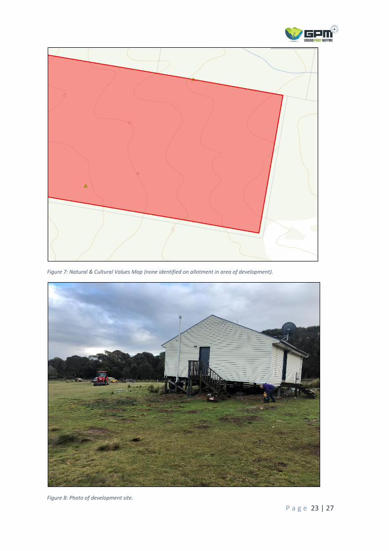
Natural and Cultural Values
No natural or cultural values were identified on site or through desktop assessments, which would prevent the
clearing and or maintenance of vegetation communities within the Hazard Management Area for achieving BAL
– 12.5 classification. The following resources were checked as part of the desktop assessment;
• Natural Values Atlas – DPIPWE 2015
• TasVeg 3.0 – Tasmanian Government / DPIPWE 2015
• The List – DPIPWE 2015
Other Environmental or Planning Issues
No environmental or planning issues were identified on site or through desktop assessments, including review of
the Flinders Planning Scheme 1994 – Amended June 2013, zoning and special area maps.

P a g e 14 | 27
CONCLUSIONS / RECOMMENDATIONS
This assessment covers the minimum requirements for the construction of an extension to a pre-existing Class 1A
dwelling. It is important to note that the assessment covers only the requirements from a bushfire perspective
and not any other building regulations.
The development site is located in a forested setting, within 100m of flammable woodland and grassland
vegetation communities. The risk of bushfire attack needed to be considered as the site is classified as being in a
Bushfire Prone Area and may be susceptible to bushfires in the future.
By building the extension to construction standards of a BAL – 12.5 rating, the hazard management area distances
are specified. The management and ongoing maintenance of this hazard management area in a low fuel state, in
perpetuity, as prescribed in this plan is of upmost priority in regards to bushfire risk. Private access and egress
specifications as well as the firefighting water supply are in full compliance with bushfire requirements (met at
the time of the initial dwelling build). When the development is built following the construction guidelines of
AS3959 – 2018 and other recommendations outlined in this report, it will ensure compliance with the Building
Act 2016 & Building Regulations 2016.
This report should be considered in conjunction with all other planning documents for this proposed development
in case of conflict. It is the client’s responsibility to provide this report to all relevant parties that are involved with
the planning, development or construction of this proposed extension. Any changes in relation to these functions
that may alter the proposed BAL rating, need to be addressed with GPM P/L as there may be a necessity for a
new assessment to be undertaken.
Other valuable resources in regards to bushfires and planning and preparation are available on the Tasmania Fire
Service (TFS) website @ www.fire.tas.gov.au

P a g e 15 | 27
REPORT PREPARATION & CERTIFICATION
This Bushfire Risk Assessment Report was prepared by:
Justin Cashion – Ground Proof Mapping P/L.
Signature: Date: 26/06/2020
This Bushfire Risk Assessment Report is certified by:
Justin Cashion – Ground Proof Mapping P/L.
Signature: Date: 26/06/2020
Accredited Person under part 4A of the Fire Service Act 1979: Accreditation No: BFP-112
Certificate: GPM 20 - 030

P a g e 16 | 27
DEFINITIONS
Term Definition
accredited person Means as defined in the act
BAL A means of measuring the severity of a building’s potential exposure to ember attack, radiant heat and direct flame contact, using increments of radiant heat expressed in kilowatts per square metre, which is the basis for establishing the requirements for construction to improve protection of building elements from attack by a bushfire (AS 3959-2009).
BAL ratings Used as the basis for establishing the requirements for construction to improve protection of a (proposed) building from bushfire attack. There are 6 BAL ratings; low, 12.5, 19, 29, 40 and FZ.
bushfire hazard management plan Means as defined in the Act
bushfire-prone area Means: land that is within the boundary of a bushfire-prone area shown on an overlay on a planning scheme map; and where there is no overlay on a planning scheme map, or where the land is outside the boundary of a bushfire-prone area shown on an overlay on such a map, land that is within 100m of an area of bushfire-prone vegetation equal to or greater than 1 hectare.
bushfire-prone vegetation Means contiguous vegetation including grasses and shrubs but not including maintained lawns, parks and gardens, nature strips, plant nurseries, golf courses, vineyards, orchards or vegetation on land that is used for horticultural purposes.
contiguous Means separated by less than 20m.
defendable space An area of land around a building where vegetation is modified and managed to reduce the effects of flame contact and radiant heat associated with a bushfire.
hazard management zone / area Means the zone / area, between a habitable building or building area and bushfire-prone vegetation, which provides access to a fire front for firefighting, which is maintained in a minimal fuel condition and in which there are no other hazards present which will significantly contribute to the spread of a bushfire.
Part 5 agreement Means as defined in the Act.
TFS Means the Tasmanian Fire Service.
slope The slope under the classified vegetation in relation to the (proposed) building.
static water supply Means water stored in a tank, swimming pool, dam, or lake that is available for firefighting purposes at all times.
vegetation The vegetation that presents a bushfire hazard within 100 metres of the development and is classified in accordance with Clause 2.2.3 of AS 3959-2009.

P a g e 17 | 27
REFERENCES
• Standards Australia Limited. (2011). AS 3959 – 2018 – Construction of buildings in bush fire-prone areas.
• Flinders Planning Scheme 1994 – Amended June 2013.
• Australian Building Codes Board. (2019). National Construction Code - ABCB.
• Building Act 2000 & Building Regulations 2014 that remain in force by virtue of clause 3(2) of Schedule 6 of
the Building Regulations 2016.
• UTS:CLG / TFS. Development and Building in Bushfire Prone Areas course resources.
• Prime Design Project No. PD20114, 25th May 2020.
P a g e 18 | 27
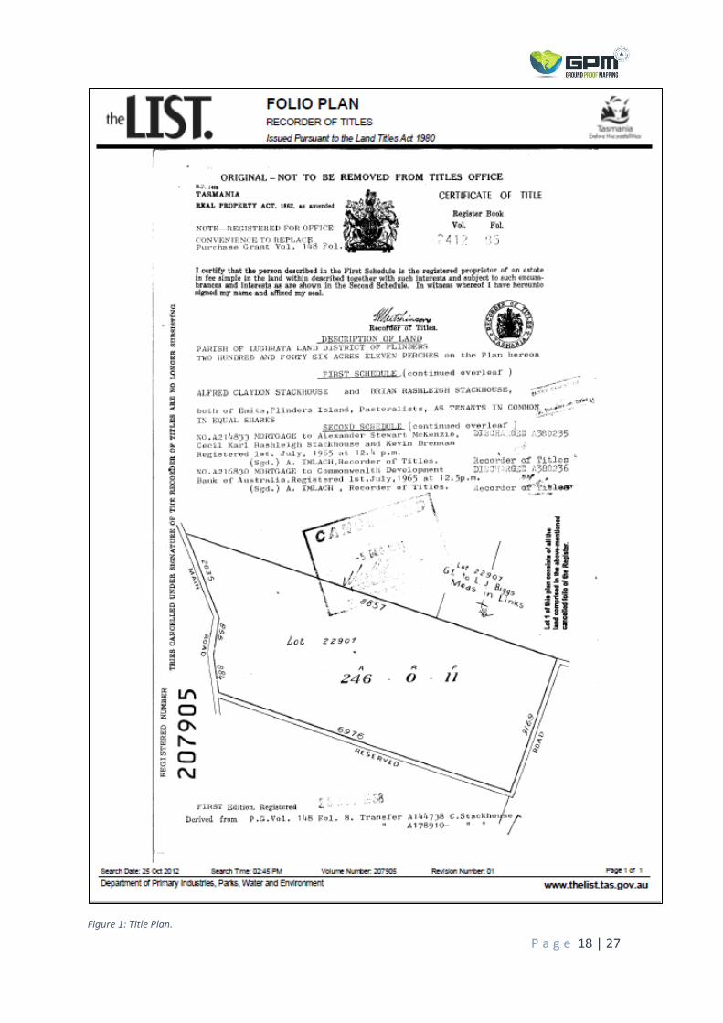
Figure 1: Title Plan.
P a g e 19 | 27
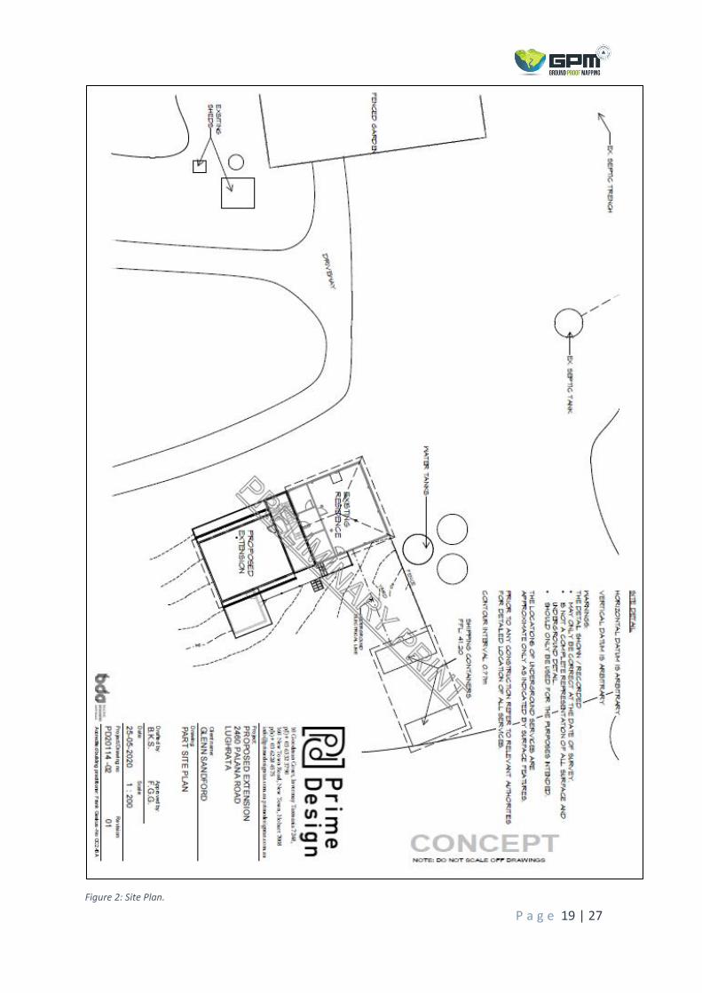
Figure 2: Site Plan.
P a g e 20 | 27
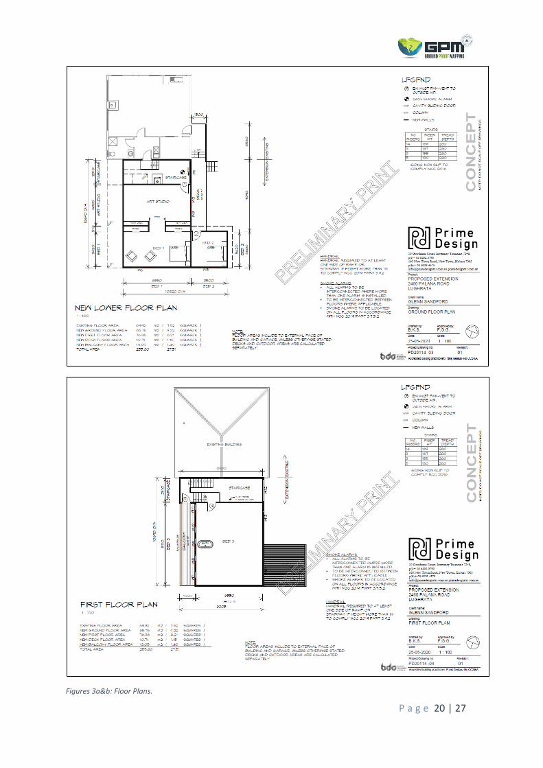
Figures 3a&b: Floor Plans.

P a g e 21 | 27
Figures 4a&b: Elevation Plans.

P a g e 22 | 27
Figure 5: Aerial View of allotment.
Figure 6: TasVeg 3.0 Map.
P a g e 23 | 27
Figure 7: Natural & Cultural Values Map (none identified on allotment in area of development).
Figure 8: Photo of development site.

P a g e 24 | 27
Figure 9: Photo to the north.
Figure 10: Photo to the east.

P a g e 25 | 27
Figure 11: Photo to the south.
Figure 12: Photo to the west.

P a g e 26 | 27
Figure 13: Accreditation Documentation.

P a g e 27 | 27
Figure 14: Copy of Insurance.

PROJECTION: Universal Transverse Mercator (UTM).
HORIZONTAL DATUM: Geocentric Datum of Australia 1994(GDA94)MAP GRID: Mapping Grid of Australia (MGA94)
Important:
State Overview Map
Disclaimer:Whilst GPM (and its agents) make every reasonable effort to locate and identify features on the land which is the subject of this map not all featureseither above or below the surface have been located. Users are advised to independently verify all data for accuracy and completeness prior to use.
Legend
ÑØ
the LIST © State of Tasmania
579800
579800
579900
579900
580000
580000
5576
600
5576
600
5576
700
5576
700
0 10 20 30 40 505Metres ´
Property Overview Map
PID Number:Client:Address:
Production Date:Assessor:Accreditation No.:Notes:
6424488
2460 Palana RoadLughrata 7255
Bushfire Hazard Management Plan Map
Justin Cashion 24/06/2020
BFP - 112
Cadastre Parcel Boundaries2460 Palana RoadExisting FootprintProposed 2 Storey ExtensionHazard Management AreaExisting Shipping Containers100m Assessment Zone
ÑØ Existing Firefighting Water TankExisting Access and Egress10m Contours StatewideHydrology Lines
Class 1A Dwelling ExtensionBAL 12.5 Solution*BHMP should be read in conjunction withBushfire Hazard Report GPM 20 - 030
SCALE 1:1000 (at A3 Print Size)
Base data from theLIST (www.thelist.tas.gov.au), © State of Tasmania100m
100m
100m
100m
WoodlandLevel/Upslope
GrasslandDownslope 0 - 5
16m
26m
WoodlandLevel/Upslope22m
22m
WoodlandDownslope 0 - 5
Glenn Sandford

Director of Building Control – Date Approved 1 July 2017 Building Act 2016 - Approved Form No. 55
CERTIFICATE OF QUALIFIED PERSON – ASSESSABLE ITEM
Section 321
To: Glenn Sandford Owner /Agent
2460 Palana Road Address
Lughrata 7255 Suburb/postcode
Qualified person details:
Qualified person: Justin Cashion
Address: 81 Elizabeth Street Phone No: 0487 476 479
Launceston 7250 Fax No: N/A
Licence No: BFP - 112 Email address: [email protected]
Qualifications and Insurance details:
Accredited to Report on Bushfire Hazards under Part IVA of the Fire Services Act 1979. Current Insurance with INTAS Insurances Services.
(description from Column 3 of the Director's Determination - Certificates by Qualified Persons for Assessable Items
Speciality area of expertise:
Analysis of Hazards in Bushfire-Prone Areas.
(description from Column 4 of the Director's Determination - Certificates by Qualified Persons for Assessable Items)
Details of work:
Address: 2460 Palana Road Lot No: 1
Lughrata 7255 Certificate of title No: 207905
The assessable item related to this certificate:
Inspection and inspection of the Bushfire Hazard and Determination of the Bushfire Attack Level (BAL) for an extension to an existing class 1A Dwelling.
(description of the assessable item being certified) Assessable item includes – - a material; - a design - a form of construction - a document - testing of a component, building
system or plumbing system - an inspection, or assessment,
performed
Certificate details:
Certificate type: Bushfire Hazard (description from Column 1 of Schedule 1 of the Director's Determination - Certificates by Qualified Persons for Assessable Items n)
This certificate is in relation to the above assessable item, at any stage, as part of - (tick one)
building work, plumbing work or plumbing installation or demolition work:
or
a building, temporary structure or plumbing installation: √
Form 55

Director of Building Control – Date Approved 1 July 2017 Building Act 2016 - Approved Form No. 55
In issuing this certificate the following matters are relevant –
Documents: Bushfire Attack Level (BAL 12.5 Solution) Assessment & Bushfire Hazard Management Plan (BHMP) for 2460 Palana Road - Lughrata.
Relevant As per AS 3959-2018 Construction of Buildings in Bushfire Prone areas and onsite findings.
calculations:
References:
AS 3959-2018 Construction of Buildings in Bushfire Prone areas. Flinders Planning Scheme 1994 – Amended June 2013. Director’s Determination – Application of Requirements for Building in Bushfire Prone Areas (Transitional) – Building Act 2000 & Building Regulations 2014 that remain in force by virtue of clause 3(2) of Schedule 6 of the Building Regulations 2016.
Substance of Certificate: (what it is that is being certified)
Bushfire Attack Level - BAL 12.5 Solution for proposed extension.
Scope and/or Limitations
This report evaluates the risks to the development associated with bushfire hazard and defines the site’s Bushfire Attack Level (BAL). It also determines the compliance of the development with the requirements of the Building Code of Australia, Director’s Determination – Application of Requirements for Building in Bushfire Prone Areas (Transitional) – Building Act 2000 & Building Regulations 2014 that remain in force by virtue of clause 3(2) of Schedule 6 of the Building Regulations 2016 and AS 3959-2018 Construction of Buildings in Bushfire Prone Areas. It recommends measures to help protect buildings from the effects of a bushfire and reduce the likelihood of fatalities arising from occupants of a dwelling who do not evacuate a property prior to exposure from a bushfire event. The information contained within this report is based on the instructions of AS 3959-2018. The Standard states that “Although this Standard is designed to improve the

Director of Building Control – Date Approved 1 July 2017 Building Act 2016 - Approved Form No. 55
performance of buildings when subjected to bushfire attack in designated bushfire-prone areas there can be no guarantee that a building will survive a bushfire event on every occasion. This is substantially due to the degree of vegetation management, the unpredictable nature and behaviour of fire and extreme weather conditions.” The effectiveness of the measures and recommendations detailed in this report are dependent on their implementation and maintenance for the life of the development. Should the site characteristics that this assessment has been measured from alter from those identified, the BAL classification may differ and cause this report to become void. The inspection has been undertaken and report provided on the understanding that the report:
• Only deals with the potential bushfire risk. All other statutory assessments are outside the scope of this report.
• Only identifies the size, volume and status of vegetation at the time the site inspection was undertaken and cannot be relied upon for any future development.
• Doesn’t deal with Impacts of future development.
• Vegetation growth has not been considered. No liability can be accepted for actions by Lot Owners, Council or Government Agencies which compromise the effectiveness of this report.
I certify the matters described in this certificate.
Signed: Certificate No: Date:
Qualified person:
GPM 20 - 030 26/06/2020