Express Bus Future Transit - Valley Metro › images › uploads › light...opportunities unique to...
2
Transit Modes T here are several types of transit considered during the planning process. The modes considered for a specific corridor will vary depending upon conditions, needs and opportunities unique to the corridor. Options can include: Express Bus Buses that make fewer stops, and operate primarily on freeways during peak commute hours. Bus Rapid Transit A limited-stop bus service that provides faster service and travel times. Bus rapid transit can operate in exclusive corridors, high-occupancy vehicle lanes, on expressways, or in mixed traffic on city streets. Bus rapid transit service can receive signal prioritization and feature quick, convenient fare collection. Modern Streetcar Streetcars operate on tracks, typically mixed with auto traffic, and are powered by overhead power lines. They differ from light rail in their vehicle size and single-car operation. Stations are also more simple and frequent than light rail. Light Rail Light rail is powered by overhead power lines and travels in a dedicated guideway alongside vehicle traffic or its own right-of-way. Light rail trains provide an extremely smooth and quiet ride, traveling at posted speed limits. A three- car train can carry as many as 600 passengers. Commuter Rail Rail service that typically uses existing freight railroad tracks and equipment. Stations are often five to ten miles apart and operations usually focus on peak-commute hours with less frequent service during off-peak hours. For more information on future transit corridors, please contact: 602.262.7433 [email protected] valleymetro.org To receive this information in alternative formats, call 602.253.5000/TTY 602.251.2039. Para recibir esta información en formatos alternativos favor de llamar al 602.253.5000/TTY 602.251.2039. For questions on or a copy of the Regional Transportation Plan, call the Maricopa Association of Governments at 602.254.6300. Download the plan from the MAG website at azmag.gov. LRT2252/12.06.13 Future Transit Corridors Bus Rapid Transit Express Bus Modern Streetcar Commuter Rail Light Rail Future Transit Corridors brochure 12-05.indd 1 12/6/2013 2:59:24 PM
Transcript of Express Bus Future Transit - Valley Metro › images › uploads › light...opportunities unique to...
Transit Modes
There are several types of transit considered during the planning process. The
modes considered for a specific corridor will vary depending upon conditions, needs and opportunities unique to the corridor. Options can include:
Express Bus Buses that make fewer stops, and operate primarily on freeways during peak commute hours.
Bus Rapid Transit A limited-stop bus service that provides faster service and travel times. Bus rapid transit can operate in exclusive corridors, high-occupancy vehicle lanes, on expressways, or in mixed traffic on city streets. Bus rapid transit service can receive signal prioritization and feature quick, convenient fare collection.
Modern Streetcar Streetcars operate on tracks, typically mixed with auto traffic, and are powered by overhead power lines. They differ from light rail in their vehicle size and single-car operation. Stations are also more simple and frequent than light rail.
Light Rail Light rail is powered by overhead power lines and travels in a dedicated guideway alongside vehicle traffic or its own right-of-way. Light rail trains provide an extremely smooth and quiet ride, traveling at posted speed limits. A three-car train can carry as many as 600 passengers.
Commuter Rail Rail service that typically uses existing freight railroad tracks and equipment. Stations are often five to ten miles apart and operations usually focus on peak-commute hours with less frequent service during off-peak hours.
For more information on future transit corridors, please contact:
602.262.7433 [email protected]
valleymetro.org
To receive this information in alternative formats, call 602.253.5000/TTY 602.251.2039.
Para recibir esta información en formatos alternativos favor de llamar al 602.253.5000/TTY 602.251.2039.
For questions on or a copy of the Regional Transportation Plan, call the Maricopa Association of
Governments at 602.254.6300. Download the plan from the MAG website at azmag.gov.
LRT2252/12.06.13
FutureTransit
CorridorsBus Rapid Transit
Express Bus
Modern Streetcar
Commuter Rail
Light Rail
Future Transit Corridors brochure 12-05.indd 1 12/6/2013 2:59:24 PM

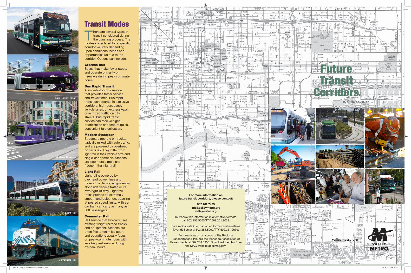
System Expansion
As one of the country’s fastest-growing metropolitan areas, the Valley of the Sun has a critical need for an expanded
transit network.
The RTP identifies six future high-capacity transit corridors. Valley Metro Rail determines the specific transit route for each corridor. Light rail, bus rapid transit, modern streetcar or another transit mode are examined to determine what will best serve the corridor. They are built using local, regional and federal funds.
Central Mesa Light Rail Extension: A 3.1-mile extension from the current end-of-line, running east on Main Street through downtown Mesa to Mesa Drive. Scheduled to open in 2016.
Gilbert Road Extension: A 1.9-mile Gilbert Road project will extend light rail from Mesa Drive on Main Street to Gilbert Road. Scheduled to open in 2018.
Northwest Light Rail Extension: A 5-mile extension from the current end-of-line, running north on 19th Avenue toward Peoria Avenue. This extension will be built in two phases, with the first phase of 3.2 miles ending at Dunlap Avenue. Phase I is scheduled to open in 2016; Phase II in 2026.
Tempe Streetcar: The region’s first modern streetcar will run in the Mill Avenue corridor and on Rio Salado Parkway and/or Apache Boulevard. Scheduled to open in 2017.
Capitol/I-10 Light Rail Extension: An 11-mile extension running west from downtown Phoenix by the State Capitol area to the I-10 freeway ending at 79th Avenue. Scheduled to open in 2023.
West Phoenix/Central Glendale: 5 miles, runs northwest into downtown Glendale. Scheduled to open in 2026. Transit mode and route to be determined.
Northeast Phoenix: 12 miles, runs northeast towards Paradise Valley Mall. Scheduled to open in 2032. Transit mode and route to be determined.
South Central Corridor Study:* An evaluation of transit routes and modes that would serve the community between downtown Phoenix and Baseline Road along Central Avenue. Study complete in 2013.
*Study is part of Phoenix’s Transit 2000 plan and also being funded by a federal grant.
Planning Process
The planning process involves identifying options and refining plans for each of the future transit corridors
identified in the RTP. The RTP outlines regional transportation improvements through 2032.
Valley Metro Rail identifies the options—potential transit routes and modes—through a formal study process known as an Alternatives Analysis. Community participation is an important part of the process, ensuring that residents, business owners, community groups and policymakers have the opportunity to provide their input.
The community involvement process includes public meetings, more focused briefings with stakeholders and presentations to policy boards and organizations. Typically, public meetings are held in an open-house format with an opportunity to ask questions and provide comment.
In addition to looking at various routes and transit modes, the Alternatives Analysis identifies the potential impacts of each option and establishes the goals and objectives that will guide the evaluation of the options.
Following the in-depth evaluation, a Locally Preferred Alternative – typically a single route and mode – is identified and carried through a public approval process. The project then continues with environmental analysis, design, construction and, finally, operation. The project development process can take approximately 12 years depending on the project mode and alignment.
Valley Metro Rail is responsible for the development and operation of the region’s high-capacity transit system. While
operating the 20-mile light rail starter line that opened in December 2008, Valley Metro Rail has also begun planning, design and construction of the 37 additional miles of high-capacity/light rail transit corridors identified in the Regional Transportation Plan (RTP).
Valley Metro Rail is a public, nonprofit, regional organization with five member cities—Phoenix, Tempe, Mesa, Glendale, and Chandler. Its Board of Directors includes representatives from each of the member cities and typically consists of mayors or city council members.
Future High Capacity Transit Corridors
60 60
202
202
101
101
101
101
101
101
10
1010
17
17
17
17
19th
Ave
Cen
tral
Ave
Washington St
Apache Blvd
Washington St / Je�erson St
Camelback Rd
Mill Ave/3rd St
7th Ave
19th Ave/Camelback
3rd St
1st Ave/Je�erso
n
12th St
24th St
Priest
Dr
Center Pkwy
University D
r/Rural
Dorsey Ln
McClintock
Smith-M
artin
Price-10
1 Fwy
38th St
44th St
Indian School
Osborn
Thomas
Encanto
McDowell
Roosevelt
Campbell
35th
Ave
43rd
Ave
Dunlap Ave
19th
Ave
Blac
k C
anyo
n Fw
y35th
Ave
Yorkshire Dr
Agu
a Fr
ia F
wy
51st
Ave
Camelback Rd
Indian School Rd
59th
Ave
67th
Ave
67th
Ave
75th
Ave
83rd
Ave
67th
Ave
59th
Ave
75th
Ave
7th
Ave
Montebello AveBethany Home Rd
Indian School Rd
Thomas Rd
Chaparral Rd
Thomas Rd
Grand Ave
McDowell RdMcDowell Rd
91st
Ave
Papago FwyVan Buren St
University Dr
Cou
ntry
Clu
b D
r
Mes
a D
r
Cen
ter S
t
Stap
ley
Dr
Gilb
ert R
d
Lind
say
Rd
Val V
ista
Dr
Ari
zona
Ave
Alm
a Sc
hool
Rd
Dob
son
RdSy
cam
ore
Rura
l Rd
Rura
l Rd
Scot
tsda
le R
d
Hay
den
Rd
Prie
st D
r
Mill
Ave
Har
dy D
r
Hoh
okam
Fw
y48
th S
t
Pric
e Fw
y
Baseline Rd
Guadalupe Rd
McKellips Rd
McDowell Rd
Beeline Hwy
Brown Rd
Main StBroadway Rd
Southern AveSuperstition Fwy
Buckeye Rd
Lower Buckeye Rd
Southern Ave
Broadway Rd
Baseline Rd
Dobbins Rd
75th
Ave
51st
Ave
43rd
Ave
27th
Ave
19th
Ave
15th
Ave
7th
Ave
7th
StCe
ntra
l Ave
16th
St
24th
St
32nd
St
Shea BlvdShea Blvd
Cactus Rd
Cav
e C
reek
Rd
Glendale Ave
Northern Ave
7th
St
Greenway PkwyGreenway Rd
Thunderbird Rd
Cactus Rd
Peoria Ave
103r
d A
ve
56th
St
64th
St
Bell Rd
40th
St
32nd
St
Pies
tew
a Fw
y
Tatu
m B
lvd
Mayo Blvd
Pim
a Fw
y
Thunderbird Rd
PHX Sky Train
Tempe Transport.
Ctr.
Veterans Way/
College Ave
Central S
tation
Van Buren/Central/1st
Ave
Ed Pastor
19th Ave/Montebello
Sunnyslope
Sycamore/Main St
Central A
ve/Camelback
Metrocenter
Paradise Valley Mall
Desert Sky Mall
Bell/I-17 (DeerValley)
Shea Blvd/SR-51(Dreamy Draw)
79th Ave/I-10
Glendale
Gilbert/McDowell
SR-51/Bell
Peoria
Mayo ClinicPhoenix Campus
Phoenix Sky HarborInternational Airport
Mayo ClinicScottsdale
HohokamStadium
Paradise ValleyCommunity College
GILBERT
MESA
SCOTTSDALE
PARADISEVALLEYGLENDALE
TOLLESON
GUADALUPE
PEORIAPHOENIX
TEMPE
20262026
20162016
20172017
20162016
20232023
20262026
20342034
20182018
LEGEND
Light Rail
Park-and-Ride
Transit Center
N 0 1 2 3 4 5Miles
Scale is approximate.
valleymetro.org602.253.5000TTY: 602 251.2039
Central Mesa Light Rail ExtensionGilbert Rd Light Rail ExtensionNorthwest Light Rail Extension Phase INorthwest Light Rail Extension Phase IICapitol/I-10 West Light Rail ExtensionSouth Central Corridor StudyTempe StreetcarFuture High Capacity/Transit CorridorsValley Metro Light Rail Line Valley Metro Light Rail Station
Note: Dates indicate calendar year openings
Future Transit Corridors brochure 12-05.indd 2 12/6/2013 2:59:27 PM