Exploring the relationships between Web usability and students' perceived learning in Web-based

3
Exploring the Usability of GPSed Records:
A data typological approach*
Hiromi MORI†
Summary
Up until quite recently, location information on surveyed units, for example, of
households, establishments and enterprises, has been collected as area information,
such as tract codes and municipality codes, in which one-to-one correspondences
between the unit and the location information are not provided, despite the fact that
each unit has inherently unique information in terms of its location.
This paper first addresses the issue that ambiguity of data due to insufficiently
obtained location information under questionnaire-based surveys gives rise to several
constraints in their use. Latest developments in information technologies have
opened up new possibilities for the application of GPS for statistical purposes. One
can create GPSed records by assigning relevant GPS codes to respective survey results.
Compared with non GPSed records, GPSed records appear to yield several benefits.
Thus, the remainder of the paper highlights the potential function of GPS codes with
respect to the possibilities of cross-sectional as well as longitudinal data fusion, which
is expected to explore new frontiers in integrated data production by expanding the
dimensions of existing records. The discussion in this paper also implies that GPS
coordinates are one of the possible key variables applicable to the integration of data.
Keywords: GPS, data archive, data fusion, data integration
1. Introduction
In modern census, enumerating activities have been conducted at each census
* This paper is based on a presentation “Exploring Usability of GPSed Records- A
data typological approach” made at the workshop “Statistical Innovation: Use of
GPS and GSM data and integration” organized by Central Bureau of Statistics
Netherlands on September 6, 2010 in Heerlen. An earlier version of this paper
was already published in March 2011 on Statistics (The Japan Society of Economic
Statistics), No.100. † Faculty of Economics, Hosei University
4342 Aihara, Machida-shi, Tokyo, JAPAN 194-0298

4
tract, which exclusively covers the whole scope of national territory. Census tracts
were introduced with the intent of avoiding counting failures as well as multiple
counting. Although some surveys inquire about respondents’ addresses, in most cases,
location information of surveyed units is given either by region or tract code. The
tract code has been used as the minimal unit to represent the location information of
surveyed units within the tract. In other words, surveyed units in a particular tract
have shared identical code numbers to represent their locations.
Modern information technology has provided a substantial breakthrough in
obtaining the location information of surveyed units. Due to advanced information
technology, together with the wide-spread use of reasonably-priced handheld PCs, the
Global Positioning System (GPS), originally introduced as a military invention, is now
widely applied in various fields as a civilian technology.
The aims of this paper are twofold: first to document a set of problems caused by
the insufficient collection of the location information of surveyed units, and second to
draw a sketch of the potential uses of GPSed records with regard to the typology of
data.
2. Statistical surveys and the dual nature of surveyed records
In conducting surveys, information is collected from surveyed units such as
persons, households, establishments, enterprises and so on, through the use of
questionnaires. The information obtained concerning surveyed units is usually
arrayed as a record format, which, however, has a dual nature.
It is obvious that the obtained data, i.e. the various attributes, activities and
results, are ascribed to each surveyed unit. That is, individual records have been
regarded as statistical copies of the surveyed unit. Another aspect is less obvious
compared with the first one. The surveyed information belongs to or relates to the
units that are located at a particular geographical point, i.e. a dwelling unit or site
where business activities are carried out. Put differently, a set of informational data
offered by surveyed units are related to some particular geographical point. One may
term the former “unit information” and the latter “spot information.”
Spot information obtained from observations in a single survey is less obvious
than unit information, because spot information refers not to the unit itself but to its
locational existence. Repeated observations, however, may more clearly address the
dual nature of the records. When the same unit has been repeatedly observed in a
series of surveys or censuses, the obtained records may reflect longitudinal change in
the relevant unit. When the same spot has been observed in repeated surveys, it will
document the kind of activities of one fixed point at different moments.
As these two aspects which the surveyed records inherently possess in a latent
manner are substantially dynamic in nature, they may split off in cases when units

5
change their locations over a period of time. Although the majority of the surveyed
units continue to stay at the same spots, the replacement of units may possibly take
place in surveys conducted at certain intervals. Different units may be observed in
ensuing surveys at the same spot due to the replacement of units, i.e. by a former unit
moving out followed by a substitute moving in. The observed spots in the previous
survey can disappear, whether or not the dwelling units are existent, in cases when no
succeeding tenants accommodate that dwelling unit. It may also be possible that new
entrants are surveyed at new spots. Families can be occupants either of newly
constructed or formerly being unsettled dwelling units, while establishments and
companies can launch their business activities either at newly developed industrial
sites or ones that were formerly unoccupied when the previous survey was conducted.
Statistics has long been regarded as a science dealing primarily with massive
phenomena. In traditional statistics, therefore, surveyed units used to be regarded
simply as elements that mold a population or subpopulation. It was only in the latter
half of the 20th century that statisticians began to shed light on individual survey
records.
Due to these traditional statistical ideas, together with several technological
constraints, statistics remained tolerant of the insufficient use of the location
information inherent in survey records. Although surveyed units such as households,
establishments and enterprises mostly have definite location information regarding
their existence, survey records documented them not at their particular points, but
only as one of the component units of the tract. Instead of specified location codes
inherent to respective surveyed units, a tract code number was given to all surveyed
units that belonged to a particular tract. Each unit’s location information was
collected not as a geographical point, but as small area. Because insufficient location
information was obtained, statistics had to put up with “diluted” information in terms
of the location of units that resulted in a number of constraints on its use. Figure 1
illustrates examples of traditional household and establishment/enterprise record
layout forms.
surve
y identific
ation c
ode
year
date ofsurvey
Household survey record
locationcodes
survey items
item
3
・・・
date
pre
fectu
ral code
Enterprise/establishment record
date ofsurvey
locationcodes
survey items
address
startup date
capital size
num
ber o
f em
ploye
es
item
1
item
2
nam
e
ZIP
code
surve
y identific
ation c
ode
year
date
pre
fectu
ral code
city c
ode
surve
y tract c
ode
item
1
item
2
item
3
・・・
city c
ode
surve
y tract c
ode
family sam
ple n
um
ber
seq. n
um
ber o
f ind. in
family
Figure 1. Examples of record layout forms
6
3. Information constraints of tract-based records
(1) Problems caused by border rezoning
While Japan had more than 12,000 cities, towns and villages in the 1950s, the
number had diminished drastically to about 2,200 by the year 2005. The annexation
and reorganization of municipalities are real threats to statistical comparability, since
they require enormous amounts of clerical work to adjust historical statistics to the
newly arrayed boundaries. The rezoning of boundaries renders time series regional
data less consistent.
Census tracts are not totally immune from boundary rezoning. The completion of
new roads and railways and the development of new residential areas make existing
tract maps obsolete. Some tracts have been partitioned and then annexed to several
neighboring tracts, while several others have been totally reorganized. Such tract
rezoning also disturbs the comparability of small area time series data. The Basic
Unit Block (BUB) was introduced in Japan in 1990 as the minimal survey tract area of
a more or less durable nature. Although these are expected to be more robust than
census tracts, they still are not always free from restructuring.
(2) Allocation of surveyed units in tracts
Grid Square Statistics were introduced in Japan based on the 1970 census data.
Under this system, the whole national territory is divided into rectangles of about one
square kilometer and 500 square meters by longitudinal and latitudinal lines . These
grids are called “basic grid squares” and “half grid squares,” respectively.
Since the geodetic line partitions areas mechanically into a set of uniform grids,
they can be independent of any municipality rezoning and of tract reorganization. As
case 0 in Figure 2 illustrates, for tracts that are totally included in a particular grid,
the whole of their elements are properly allocated to that grid. In the case where the
grid borders cross the tracts, however, tract elements, i.e. the surveyed unit records,
should be processed in such a way as to cope with the problems of how to allocate them
among grids in an appropriate manner. In all remaining cases, surveyed units are
allocated more or less by approximation (case 1-1) or by calculation (cases 1-2, 2-1, 2-2
and 3). In either case from 1-1 through 3, an ambiguity occurs in converting
tract-based data into grid-based data.

7
Source: http://www.stat.go.jp/data/mesh/pdf/gaiyo2.pdf (pp.24, 26 and 28)
Figure 2. Allocation of tract units among grid squares
(3) Inadaptability of data for buffering analysis
Buffering analysis is now widely used to identify buffered polygon areas with a
fixed distance surrounding specified input features, which can be polygons, lines or
points. Since buffer polygon borderlines do not necessarily coincide with those of
tracts, borders usually intercross. Similar to the grid estimates, estimates for
buffered polygons, therefore, are usually subject to the ambiguity caused by
inconsistent borders. Buffered circles and polygons usually have indented fringes due
to the discordance of bordering.
All these difficulties, yielded in the process of allocating surveyed units in tracts to
relevant areas, derive from insufficiently obtained location information in surveys.
4. Obtaining GPS coordinates
Developments in information technologies have opened up a new scope in
obtaining location information from each surveyed unit. Similar to the Internet, GPS
was originally invented and has been utilized primarily for military purposes.
Thanks to improvements in the accuracy of digital map software, together with
widespread use of information terminals furnished with various GIS softwares, GPS
now enjoys a wider acceptance in daily life as necessary information infrastructure.

8
Official statistics, however, are relative latecomers in applying GPS for their practices.
Directly obtaining GPS coordinates through mobile terminals and indirect access
to them either by means of address-GPS converting software or by applying
appropriate calculation methodologies served as a powerful driving force for statistics
to explore the wider dimensions of the applicability of coordinates, not only for the use
of data but also for the production of data of improved quality. GPS coordinates
collected by field workers in address canvassing for the 2010 U.S. Population Census
are used to pinpoint the residences of non-responders, and thus to improve the
response rate. Statistics Poland is planning to collect GPS coordinates in the 2011
Census.
Besides such applications of GPS coordinates in the survey process, they are
expected to provide a wider dimension of inputs to statistical practices. As one of the
major aims of this paper is to address the characteristics of individual records with
GPS coordinates (hereinafter termed GPSed records), it would be convenient to provide
here a rough image of GPSed records. The diagrams in Figure 3 document images of a
data format for GPSed records.
Enterprise/establishment record
city c
ode
nam
e
capital size
startup date
GP
S c
oodin
ate X
GP
S c
oodin
ate Y
ZIP
code
address
date ofsurvey
location codes survey items
num
ber o
f em
ploye
es
date
prefe
ctu
ral code
・・・
surve
y identific
ation c
ode
year
Household survey record
date ofsurvey
location codes survey items
・・・
city c
ode
GP
S c
oodin
ate X
GP
S c
oodin
ate Y
item
3
surve
y identific
ation c
ode
year
date
prefe
ctu
ral code
family sam
ple n
um
ber
seq. n
um
ber o
f ind. in
family
item
1
item
2
Figure 3. Examples of GPSed records
Unlike tract-coded records, GPSed records provide definite location information of
surveyed units. As stated above, ambiguity in the use of data has sprung
substantially from area-based locating. GPS coordinates are more appropriate
variables than tract codes in terms of identifying the geographical points of surveyed
units’ existence. Once GPS coordinates are tacked to individual records by some
measure or other, it becomes possible to allocate surveyed units not by estimation but
by direct assorting of surveyed units according to the coordinate information. Units
such as families, establishments and enterprises will be surveyed intrinsically at the
very point of their existence. It was not until the obtaining of coordinate information
that statistics became able to employ location information on an extensive scale.
GPS coordinates tacked to each record as one of the unit’s basic attributes will
enable to liquidate the ambiguity described above. By doing so, all archived records

9
will be able to cope with any form of zoning. GPSed time series records can enjoy
longitudinal comparability in full scale. Furthermore, they are qualified to compile
statistics that can meet any buffered zones.
Besides these advantages, GPSed records appear to have additional attributes.
The following paragraphs will discuss potential uses of GPSed datasets with regard to
the typology of data.
5. GPSed records by type of datasets
Datasets can be classified into several subcategories by kinds of surveyed units
and forms of datasets. Additional variables that account for the datasets will also be
introduced to characterize the specific nature and usability of GPSed datasets.
A single census or survey result provides a snapshot of the surveyed units at a
particular date that forms a single cross-sectional dataset. A series of censuses or
surveys conducted repeatedly during the sequence of time will give repeated snapshots.
These snapshots usually comprise repeated cross-sectional datasets. Leaving aside
censuses, a series of survey results do not necessarily cover the same surveyed unit.
Repeated cross-sectional datasets, therefore, do not portray snapshot observations of
the same set of surveyed units. When the same units are surveyed repeatedly in a
series of surveys, one can compile longitudinal datasets that form a matrix of N
surveyed units and T periods for each surveyed variable. However, the number of
surveyed units in each snapshot is not always the same in the longitudinal dataset
because of the attrition of the surveyed samples. Including unbalanced datasets with
an unequal number of surveyed units in each snapshot, the author simply terms such
datasets here as longitudinal.
As for the nature of surveyed units, we will focus our discussion on the GPSed
records of surveyed units with a rather stable nature in terms of their geographical
locations. Thus, locations, i.e. dwelling units usually inhabited by families and sites
where establishments/enterprises perform their economic activities, are currently our
major concerns in discussing GPSed records. Individual records loaded with GPS
coordinates involve in themselves a potential moment to breakaway the dual nature
that seems to be inseparably integrated in the surveyed records. This separation will
turn out to be pronounced in the repeated snapshot datasets such as repeated
cross-sectional and longitudinal datasets.
10
6. Possible uses of GPSed records by type of datasets
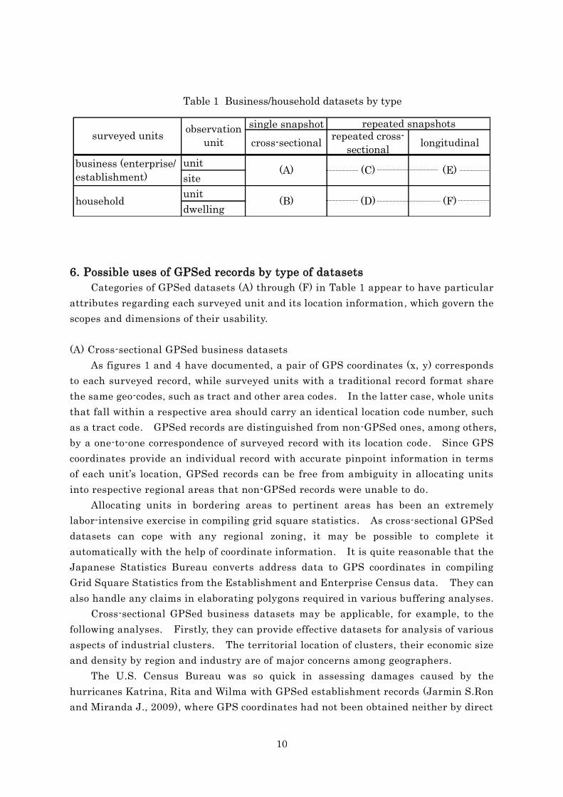
Categories of GPSed datasets (A) through (F) in Table 1 appear to have particular
attributes regarding each surveyed unit and its location information, which govern the
scopes and dimensions of their usability.
(A) Cross-sectional GPSed business datasets
As figures 1 and 4 have documented, a pair of GPS coordinates (x, y) corresponds
to each surveyed record, while surveyed units with a traditional record format share
the same geo-codes, such as tract and other area codes. In the latter case, whole units
that fall within a respective area should carry an identical location code number, such
as a tract code. GPSed records are distinguished from non-GPSed ones, among others,
by a one-to-one correspondence of surveyed record with its location code. Since GPS
coordinates provide an individual record with accurate pinpoint information in terms
of each unit’s location, GPSed records can be free from ambiguity in allocating units
into respective regional areas that non-GPSed records were unable to do.
Allocating units in bordering areas to pertinent areas has been an extremely
labor-intensive exercise in compiling grid square statistics. As cross-sectional GPSed
datasets can cope with any regional zoning, it may be possible to complete it
automatically with the help of coordinate information. It is quite reasonable that the
Japanese Statistics Bureau converts address data to GPS coordinates in compiling
Grid Square Statistics from the Establishment and Enterprise Census data. They can
also handle any claims in elaborating polygons required in various buffering analyses.
Cross-sectional GPSed business datasets may be applicable, for example, to the
following analyses. Firstly, they can provide effective datasets for analysis of various
aspects of industrial clusters. The territorial location of clusters, their economic size
and density by region and industry are of major concerns among geographers.
The U.S. Census Bureau was so quick in assessing damages caused by the
hurricanes Katrina, Rita and Wilma with GPSed establishment records (Jarmin S.Ron
and Miranda J., 2009), where GPS coordinates had not been obtained neither by direct
Table 1 Business/household datasets by type
single snapshot
cross-sectionalrepeated cross-
sectionallongitudinal
unit
site
unit
dwelling(F)household
(A)
(B)
(C)
(D)
repeated snapshotssurveyed units
observation
unit
business (enterprise/
establishment)(E)

11
positioning the sites by field surveyors nor through address matching , but through
calculation measures they loaded individual establishment records with coordinates .
This case study offers one smart example demonstrating the potential usability of
GPSed datasets, for example, in the field of disaster damage prevention. Central and
local governments of most countries have already furnished various hazard maps.
One may easily assess the extent of damage by overlaying GPSed records on hazard
maps using coordinates as linking keys.
It is worth noting that GPSed cross-sectional records also have an advantage in
enlarging the information potential of data by means of expanding dimensions through
data fusion. Among individual records from multiple sources such as censuses, sets of
heterogeneous surveys and administrative records, there may exist some which carry
identical coordinate information. However, such cross-sectional record linkages are
“pseudo,” because it is not necessarily the relevant business units that were combined
with each other as unified records in extended dimensions. The latest developments
in statistics have shed light on data fusion as one of the possible expansions of
information potential. Records with a multiplied number of variables generated by
the coordinate-based cross-sectional data fusion among heterogeneous business
records may allow intensive analyses that a single set of records could never hope to
achieve.
(B) Cross-sectional GPSed household datasets
Unlike tract coded records, which share an identical polygon code number among
surveyed units, each household record in GPSed datasets usually has a unique location
code relative to the coordinate information of the dwelling unit. Although
multiple-floor apartment houses may possibly be codified by one and the same pair of
coordinates, coordinates may still retain their validity as location indicator. GPS
coordinates are also expected to expand their dimensions, for example, by introducing
an additional variable that denotes floor information.
GPSed household datasets are more informative than tract coded ones in
analytical usability, because they are qualified to accommodate themselves to a wide
spectrum of regional zoning. One can estimate or assess the number of casualties
from natural disasters such as floods and earthquakes by overlaying the GPSed
records upon hazard maps. Statistical assessments of governmental services may
also be possible by scoring accessibility to public facilities. GPSed household datasets
capable of meeting any buffering analyses are also attractive to businesses in mining
potential local markets by calculating the size, compositions, density and income
distribution of subpopulations in relevant buffering areas.
Expanding the potentials of existing data by data fusing records is also valid for
household records. Despite the pseudo manner of data linkage, the compiled datasets
with multiplied dimensions of variables will enable intensive analyses that may bring

12
about new findings.
(C) Repeated cross-sectional GPSed business datasets
Since coordinates are distinct in indicating the location of units, one can obtain
results not by estimation but by the direct counting of units through a vector algorism
applicable to any levels of polygons. GPSed records can display their advantages over
other location codes, among others, in time series regional comparisons. Once
individual records are archived with appropriate coordinates, they will become able to
release the data from every constraint in time series comparisons that was formerly
caused by restructured borders. Allocating units to each pertinent polygon by the
help of coordinate information will make possible prospective as well as retrospective
regional comparisons.
Repeated cross-sectional GPSed business datasets obtained by a series of surveys
will offer users a periodical chain of snapshots on the activities of business units and
behaviors. They can be applied to the analysis, for example, of the dynamism of an
industrial cluster. With these types of datasets one can draw a series of pictures that
illustrate the trend of diffusion or contraction of industrial clusters and can analyze
business demographic events such as the entry or exit of units to or from the cluster.
One of the characteristic features of the repeated cross-sectional GPSed datasets
is the possibility of longitudinal expansion of data dimensions. When we focus our
interest on the location information of surveyed units given by the coordinates of sites
where establishments or companies currently perform their activities, a new type of
dataset, i.e. a pseudo panel dataset of establishments or companies will be compiled by
fusing records by means of coordinates. The dataset is pseudo in the sense that
establishments or companies that perform their business activities at the respective
sites are not necessarily identical units. Business being performed at a particular
site may alter by the exits of units followed by substitute entries during the period of
time in question. However, as it is expected that an overwhelming majority of
business units continue to carry out their activities at the same sites they have
occupied in the past, we regard the compiled datasets as a panel in the broader sense.
When one changes ones viewpoint to the location where each unit was actually
surveyed, however, both panel datasets are “genuine” in nature. Put differently, GPS
coordinates are qualified to work as effective key variables to generate panel datasets
out of unpaneled repeated cross-sectional datasets. Thus, panel-based analyses
would be applicable to these types of datasets.
(D) Repeated cross-sectional GPSed household datasets
Repeated cross-sectional GPSed household datasets give a chain of snapshots
focused on the activities and behaviors of families over the course of time. Thanks to
the coordinates, the datasets can support any restructuring of regional zones. One

13
can analyze various dynamic aspects of population and families by each region using
this type of dataset. Comparison of the ageing tempo of populations by region, for
example, is of importance for policymakers who are keen on reallocating budgets.
When one regards repeated cross-sectional GPSed household datasets from the
viewpoint of GPS coordinates, individual household records are reorganized into
pseudo panel datasets. Similar to the business datasets, those compiled from
repeated cross-sectional GPSed household datasets are still pseudo in terms of
longitudinal attributes, because coordinates are linked not to respective families, but
only to the dwelling units. Even in cases where household records carry unchanged
coordinates in repeated cross-sectional datasets, there may possibly be replacements of
families in dwelling units caused by the moving out of a family followed by moving in of
another family. It is well expected, however, that in the majority of cases families
continue to reside at the same dwelling units. Unless panel datasets in the true sense
are available for households, pseudo panel datasets compiled by means of record
linkage using GPS coordinates as matching keys would be applicable as one of the
feasible options of a secondary approach to family demographic events analyses.
(E) Longitudinal GPSed business datasets
By the turn of the 21st century, business statistics in most countries had already
become equipped with business registers that now serve as fundamental survey
infrastructure as well as a particular machine to produce relevant statistics.
Business registers in many countries have already stepped up to the second generation
phase as databases with a longitudinal dimension in order to be able to meet the
analytical needs of business demography. A business register, as the core segment of
a relational database, forms a backbone for the integration of a wide spectrum of
business statistical records both in cross-sectional and longitudinal dimensions. A
systematic coding of the ID numbers of business units is a prerequisite for the effective
functioning of the database. Longitudinal records in themselves contain elements of
business demography, such as launching a business (entry), survival, dormancy
(suspension) and quitting (exit).
GPSed longitudinal datasets are far more informative than non GPSed ones.
Longitudinal records armed with GPS coordinates are qualified to objectify the dual
aspect, i.e. unit and site information which the individual records have carried latently.
When one focuses upon surveyed units, unchanged coordinates indicate their survival,
while the changed ones suggest the redeployment of the unit. If one switches the
viewpoint to sites, records illustrate the activities of the units operated at the
particular site specified by the coordinates. Put differently, it will establish the kinds
of functions or potentials of the respective sites.
GPSed longitudinal business datasets can identify the following events. When
one focuses on the business unit in the dataset, its coordinates provide information

14
regarding the unit’s relocations in the course of time. Since the unit is identified by
the competent ID number, one can easily distinguish redeployment from quitting.
GPS coordinates are more advantageous than descriptive address information in
terms of data processing in identifying the redeployments of units. Addresses tend to
be mistyped, while coordinates can maintain consistency even in cases when addresses
are amended by occasional address recording.
Business units go through a set of demographic events throughout the period of
their activities. When one focuses on the coordinates, surveyed unit records being
identifiable by unit code number may denote the demographic events of the business
unit, such as survivals, entries, exits which come about at a particular site. Thanks
to the unit ID number, it is possible to distinguish new entries from the moving in of
existing units due to redeployment and also exits from the moving out of units. It is
expected that GPSed records can partly substitute for the profiling work of business
units, which is actually quite labor-intensive clerical work, through automatic data
processing.
By controlling site information, GPSed longitudinal business datasets would be
applicable to establish, for example, the business unit redeployment ratio by size and
industry and compare the ratios between single and multiple establishment businesses
or grouped or single enterprises.
(F) Longitudinal GPSed household datasets
Building longitudinal household databases may currently remain a far-reaching
project issue for most countries. However, Nordic countries have already switched
over their statistical systems to register-based ones. Central Bureau of Statistics
(CBS) of the Netherlands has constructed a modern version of the System of Social and
Demographic Statistics (SSDS) as the Social Statistical Database (SSD), which is
realized as a relational database with population register at its core segment and
integrates many other household files as satellites.
As business registers have evolved, as a matter of course, from the first generation
of the business frame that only reflected a static aspect of the business population to
ones with longitudinal attributes, household registers will likely follow similar steps in
the future. In this sense, the current status of statistical practices regarding
household registers may be rather premature for the following discussion on the
potential usability of GPSed longitudinal datasets.
Longitudinal household datasets can be compiled through matching records by
family ID number. If no ID number is available, householders’ names will substitute
for the ID. Similar to the longitudinal business records, household records carry a
dual implication. The record tells a story about the units themselves, i.e. families or
individuals who share the dwelling unit on one side, and provides information on the
functioning of respective dwelling units in terms of habitation on the other.
15
If we direct our concerns to units, i.e. families or individuals, a changed set of
coordinates will trace the family or personal history of residential moves. This type of
dataset is expected to provide relevant materials for analyzing the geographical
residential moves of families or individuals in each stage of a family’s or an
individual’s life cycle.
Longitudinal household datasets focused on dwelling units can draw another
picture of the habitation behavior of residents. Household records reported from
residents with unchanged coordinates may give either the same family ID number / the
name of householder or differed ones in a series of snapshots. By overlaying family
ID number or the name of householder on respective coordinates, one can compile a
dataset that helps to shed light on the occupancy status of dwelling units. Unchanged
ID numbers suggest that the same families or individuals continue to reside at the
same dwelling units, while changed ID numbers indicate replacement of families or
individuals. The coordinates that became extinct in the GPSed longitudinal datasets
compiled of household-based survey results may indicate a vacancy or a halt of
operation as residential dwelling units, while newly emerged coordinates suggest new
engagements as residences. The datasets will be applicable to the identification of
residential mobility, for example, by region and tenure.
7. Concluding remarks
Official statistics, which have collected information from surveyed units primarily
to compile statistical tables, have experienced several historic turnabouts during the
second half of the 20th century. Instead of macro-based datasets, the component of
which are substantially aggregate statistics, users increasingly direct their concerns
toward disaggregate data in the belief that the latter could portray novel images on
population that aggregate data approaches were unable to attain.
Transition of the system of statistics from that made up substantially of
stand-alone surveys to micro-based integration of surveyed and administrative records
is another remarkable development. Collected information, which was formerly of
temporary value for tabulating purposes, is more and more regarded as a sort of
information asset of a durable nature that can meet long-standing and varied uses.
It is quite reasonable that contemporary needs for statistics require the archiving
of obtained data which can withstand long term comparability and enable
cross-sectional as well as longitudinal expansions of dimensions of archived records.
The focus on GPS coordinates themselves in this paper derives from the anticipation
that the loading of surveyed records with coordinates might be one of the possible
options in designing data archives.
The use of GPS coordinates in official statistics is one of the recent remarkable
developments in world statistics. Due mainly to technological and partly to social

16
constraints, it was not until quite recently that statisticians began to turn their
attention to the extensive use of location coordinates for statistical purposes.
Although questionnaire-based surveys are qualified potentially to collect
information that belongs or relates to each surveyed unit, traditional surveys have
offered location information in an aggregate manner as tract codes. Because of the
ambiguity of available location information that arises from tract-coded records,
survey results were subject to several constraints in use, especially in time series
regional analyses.
This paper has given evidence for the following issues. First, besides information
on the surveyed units, individual records also carry information about the locations of
units in latent manner. Second, due to the aggregate nature of coding in terms of the
location of units, transferred unit records from returned questionnaires, which are
insufficient in giving the location information of units, have placed restrictions on
their use. Third, as a typological approach has evidenced, repeated cross-sectional
and, among others, longitudinal datasets can highlight location information given by
the coordinates with special implications that may represent a sort of potential
inherent in the respective spots. Finally, corresponding to each type of datasets, we
have explored some new possibilities for GPSed records’ usability.
As addressed by U.S. practices, GPS coordinates are also promising in producing
better quality data. Dutch attempts may explore new potential uses in obtaining
statistics otherwise almost unobtainable by conventional methods. Further seminal
elaborations in the application of GPS coordinates in statistics may enrich the
discussions being put forward in this paper. It is expected that new types of datasets
armed with GPS coordinates will explore new frontiers in the field of statistics.
REFERENCE
Jarmin S.Ron and Miranda J., (2009) “The Impact of Hurricanes Katrina, Rita and
Wilma on Business Establishments: A GIS Approach” Journal of Business Valuation
and Economic Loss Analysis. Vol.4
Acknowledgement
This research has benefited from financial support through the Grant-in-Aid:
“International Comparative Studies on Archiving System of Official Statistical Data ”
(#22330070) of Japan Society for the Promotion of Science.