Exploring Bowen’s Marine World · Bowen Island Conservancy PO Box 301 Bowen Island, BC V0N 1G0 22...
58
a Exploring Bowen’s Marine World Exploring Bowen’s Marine World A Marine Atlas of Ne A Marine Atlas of Ne x xwléle wléle x xwem/Bowen Island wem/Bowen Island Len Gilday, Will Husby, and Bob Turner Len Gilday, Will Husby, and Bob Turner
Transcript of Exploring Bowen’s Marine World · Bowen Island Conservancy PO Box 301 Bowen Island, BC V0N 1G0 22...

a
Exploring Bowen’s Marine WorldExploring Bowen’s Marine WorldA Marine Atlas of NeA Marine Atlas of Nexxwlélewlélexxwem/Bowen Island wem/Bowen Island
Len Gilday, Will Husby, and Bob TurnerLen Gilday, Will Husby, and Bob Turner

2
Copyright © Bowen Island Conservancy. All rights reserved.Published May 2020.
Printed in Canada.
Bowen Island Conservancy PO Box 301Bowen Island, BCV0N 1G022 21 20 2 3 4
Library and Archives Canada Cataloguing in PublicationTitle: Exploring Bowen's marine world : a marine atlas of Nexwlélexwem/Bowen Island / Len Gilday, Will Husby and Bob Turner.Other titles: Bowen's marine world | Marine atlas of Nexwlélexwem/Bowen IslandNames: Gilday, Len, 1949- author. | Husby, Will, 1953- author. | Turner, R. J. W. (Robert J. W.), author.Description: Includes bibliographical references.Identifiers: Canadiana 20200200402 | ISBN 9781777124700 (softcover)Subjects: LCSH: Marine ecology—British Columbia—Bowen Island—Atlases. | LCSH: Bowen Island (B.C.)— Environmental conditions—Atlases. | LCGFT: Atlases.Classification: LCC G1172.B655 G55 2020 | DDC 577.709711/33—dc23
Will
Husb
y
Mar
y Le P
atou
rel
Will
Husb
y
1
Exploring Bowen’s Marine WorldA Marine Atlas of Nexwlélexwem/Bowen Island
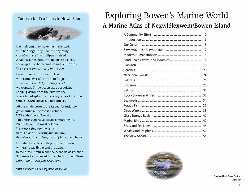
A Community Effort … … … … … … … … … … … … 2Introduction … … … … … … … … … … … … … … … 6Our Ocean … … … … … … … … … … … … … … … 8Skwxwú7mesh Úxwumixw … … … … … … … … … 12Modern Human Impacts … … … … … … … … … … … 14Food Chains, Webs, and Pyramids … … … … … … … … 16Plankton … … … … … … … … … … … … … … … … 18Beaches … … … … … … … … … … … … … … … … 20Nearshore Forests … … … … … … … … … … … … … 24Eelgrass … … … … … … … … … … … … … … … … 26Estuaries … … … … … … … … … … … … … … … … 28Salmon … … … … … … … … … … … … … … … … 30Rocky Shores and Islets … … … … … … … … … … … 32Seaweeds … … … … … … … … … … … … … … … … 34Forage Fish … … … … … … … … … … … … … … … 36Deep Waters … … … … … … … … … … … … … … … 38Glass Sponge Reefs … … … … … … … … … … … … 40Marine Birds … … … … … … … … … … … … … … … 42Seals and Sea Lions … … … … … … … … … … … … 48Whales and Dolphins … … … … … … … … … … … … 50The View Ahead … … … … … … … … … … … … … … 54
Canticle for Sea Lions in Howe Sound
Did I tell you they wake me in the dark with barking? They float the day away, close-knit, a raft with flippers raised.A sail past. Sea lions, prodigious and close, show up after the herring spawn on Hornby. I’ve never seen so many in the bay.
I want to tell you about my friendwho came over after work to forgetsome bad news. Why are they here?we wonder. Three dozen start porpoising. Looking down from the cliff, we seea sequinned splash, a breaking wave of anchovy. Gulls blizzard above, a whirl and cry.
All the while permits are issued for industry: gravel mine at the McNab estuary,LNG at the Woodfibre site.This, after expensive decades mopping up. But I tell you, we must celebrate.We must celebrate the returnin this place of herring and anchovy,the salmon that follow, the dolphins, the whales.
For what I speak is both protest and praise, witness to the living and the dying,to the present return and the probable destruction. So I must lie awake with my window open, listen there now can you hear them?
Susan Alexander, Tunstall Bay, Bowen Island, 2019
Front and Back Cover Photos:Len Gilday
2
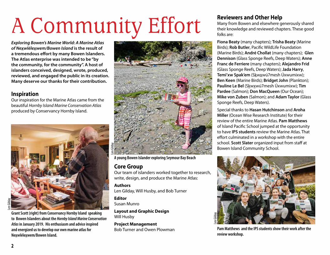
A Community EffortExploring Bowen’s Marine World: A Marine Atlas of Nexwlélexwem/Bowen Island is the result of a tremendous effort by many Bowen Islanders. The Atlas enterprise was intended to be “by the community, for the community”. A host of islanders conceived, designed, wrote, produced, reviewed, and engaged the public in its creation. Many deserve our thanks for their contribution.
InspirationOur inspiration for the Marine Atlas came from the beautiful Hornby Island Marine Conservation Atlas produced by Conservancy Hornby Island.
Reviewers and Other HelpMany from Bowen and elsewhere generously shared their knowledge and reviewed chapters. These good folks are:
Fiona Beaty (many chapters); Trisha Beaty (Marine Birds); Rob Butler, Pacific WildLife Foundation (Marine Birds); André Chollat (many chapters); Glen Dennison (Glass Sponge Reefs, Deep Waters); Anne Franc de Ferriere (many chapters); Alejandro Frid (Glass Sponge Reefs, Deep Waters); Jada Harry, Temi’xw Spak’em (Skwxwú7mesh Úxwumixw); Ben Keen (Marine Birds); Bridget John (Plankton); Pauline Le Bel (Skwxwú7mesh Úxwumixw); Tim Pardee (Salmon); Don MacQueen (Our Ocean); Mike von Zuben (Salmon); and Adam Taylor (Glass Sponge Reefs, Deep Waters).
Special thanks to Hasan Hutchinson and Aroha Miller (Ocean Wise Research Institute) for their review of the entire Marine Atlas. Pam Matthews of Island Pacific School jumped at the opportunity to have IPS students review the Marine Atlas. That effort culminated in a workshop with the entire school. Scott Slater organized input from staff at Bowen Island Community School.
Pam Matthews and the IPS students show their work after the review workshop.
Core Group Our team of islanders worked together to research, write, design, and produce the Marine Atlas:
Authors Len Gilday, Will Husby, and Bob Turner
Editor Susan Munro
Layout and Graphic DesignWill Husby
Project ManagementBob Turner and Owen Plowman
A young Bowen Islander exploring Seymour Bay Beach
Len G
ilday
Len G
ildayGrant Scott (right) from Conservancy Hornby Island speaking
to Bowen Islanders about the Hornby Island Marine Conservation Atlas in January 2019. His enthusiasm and advice inspired and energized us to develop our own marine atlas for Nexwlélexwem/Bowen Island.
Len G
ilday

3
We are also grateful to Fiona Beaty, Ben Keen, Mary Le Patourel, Karen Cowper, and Adam Taylor for sharing their personal stories about life in our marine world; to Cathy Bayly of Bowen Island Historians for her helpful research on historic photos and First Nations; and to Mary Le Patourel, John Reid, Sarama (Gibsons), and Adam Taylor for use of their beautiful photographs.Finally, special thanks to Susan Alexander for sharing her poem "Canticle for Sea Lions in Howe Sound" from her prize-winning suite of poems Vigil (soon to be published in the collection Nothing You Can Carry, Thistledown Press).
Public Engagement The primary purpose of the Marine Atlas is to catalyze conversations about the marine world around Bowen Island. The Bowen Island Conservancy held two major public engagements: at Bowfest in August 2019 and at an Open House at Bowen Island Community School in October 2019. Rosemary Knight coordinated the Bowfest volunteers while Bob Turner organized the Open House. Volunteers were: Trisha Beaty, Lori d’Agincourt-Canning, Allie Drake, Anne Franc de Ferriere, Alejandro Frid, Len Gilday, Will Husby, Hasan Hutchinson, Louise Loik, Owen Plowman, Pam Matthews, Mike Mountain, Tim Pardee, Brenda McLuhan, Emily McCullum, Nerys Poole, Cathy Robertson, Wendy Seale-Bakes, Adam Taylor, Chantal Underdown, Everhard van Lidth de Jeude, Taliesin van Lidth de Jeude Roemer, and Alan Whitehead.
Next StepsPublication of the Marine Atlas is an important milestone, but not the conclusion of the Marine Atlas project. The project seeks to foster public awareness and engagement with our local marine environment, its conservation issues, and celebrates the recovery of our marine neighbourhood. The Bowen Island Conser-vancy will build a website to promote the use of, and add to, Atlas content, and will continue to work with community partners in a variety of ways. Stay tuned! If you have any questions, feedback, or corrections to the content of the Marine Atlas, contact us at [email protected].
Local birders discussing sightings at Open House
Len G
ilday
Public review of Atlas draft at Open House
Len G
ilday
FundingWe are grateful to the Bowen Island Community Foundation for its grant when the project was just getting on its feet—your endorsement was a huge boost to our team’s morale.
Kind donations from the Ngan Page Family Fund and several anonymous private individuals also supported us in those early days. Sitka Foundation provid-ed the remaining funding and gave us the confidence that we could complete the project.
Mapping marine life encounters: Bowfest
Will
Husb
y
Mapping layers of personal marine life encounters: Bowfest
Will
Husb
y

4
Eagle Cliff
Sandy Beach (C)
Cape Roger Curtis Beach (C)
Tunstall Bay
Bowen Bay
Cates Bay
Bishop's
Baker
Pebbly Beach (N)
September Morn
Seymour Bay
Alder Cove Beach (N)
Lighthouse Lane
King Edward Bay
Clipper Place
Crayola
Woods Road
Beach (N)
Beach (N)
Beach (N)
Beach (N)
Beach (N)
Beach (N)Beach (N)
Beach (N)
Beach (N)
Beach (N)
Beach (N)
Beach (C)
Beach (C)
Crippen Regional Park
Ecological Reserve
Snug Cove
Mannion/Deep Bay
Cates Bay
Tunstall Bay
Bowen Bay
Grafton Bay
Seymour Bay
Cape Roger Curtis
Cowan Point
BBlluueewwaatteerrGrafton
Lake
KillarneyLake
Bluewater
Queen Charlotte Heights
CowanPoint
SnugCove
EagleCliff
Hood Point
MountGardner
ApodacaProvincial Park
TunstallBay
Josephine Lake
Crown Land
Millers Landing
Fairweather
Hood Point West
Passage Island
Worlcombe Island
Pasley Island
Keats Island
Hutt Island
Ferry
Columbine Bay
Dorman Bay
Onion Island
Nexwlélexwem/Bowen IslandShoreline Types
Sea Cliffs
Low Rock and Boulder
Boulder and Cobble
Sand and Pebble
Rock
Beac
h
Biological FeaturesEelgrass Sites
Salmon Feeding
Beach DesignationCommunity Beach
Neighbourhood Beach
(C)
(N)
Eelgrass RestorationArea
Area
Shorebird FeedingAreaScoter/GoldeneyeWinter Feeding AreaGeneral SeabirdWinter Feeding Area
0 1 2
Kilometres
[
Will
Husb
y
Source of information: Bowen Island Municipality (beach designations, shoreline types), Islands Trust (base map, eelgrass locations), Bowen Island Fish and Wildlife Club (salmon information), Trisha Beaty, Ben Keen (bird sightings).
5
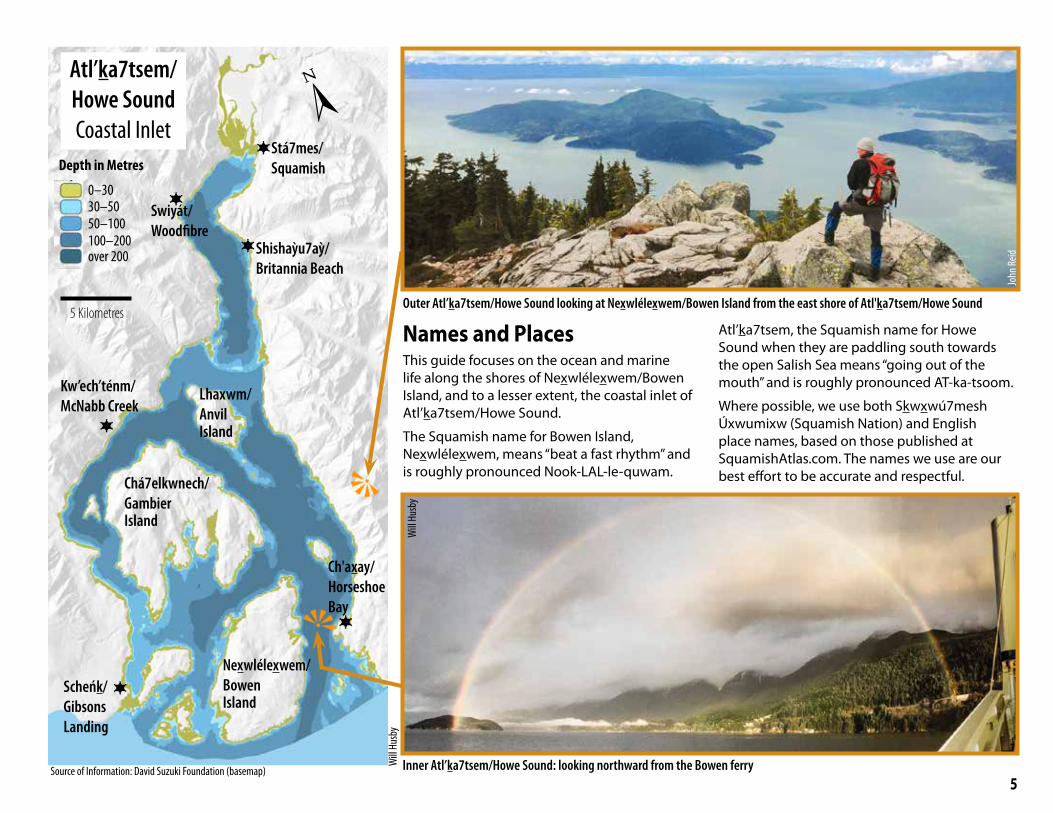
Names and Places This guide focuses on the ocean and marine life along the shores of Nexwlélexwem/Bowen Island, and to a lesser extent, the coastal inlet of Atl’ka7tsem/Howe Sound.
The Squamish name for Bowen Island, Nexwlélexwem, means “beat a fast rhythm” and is roughly pronounced Nook-LAL-le-quwam.
Atl’ka7tsem, the Squamish name for Howe Sound when they are paddling south towards the open Salish Sea means “going out of the mouth” and is roughly pronounced AT-ka-tsoom.
Where possible, we use both Skwxwú7mesh Úxwumixw (Squamish Nation) and English place names, based on those published at SquamishAtlas.com. The names we use are our best effort to be accurate and respectful.
[0–3030–5050–100100–200over 200
Depth in Metres
5 Kilometres
Nexwlélexwem/Bowen Island
Chá7elkwnech/ GambierIsland
Lhaxwm/AnvilIsland
Atl’ka7tsem/ Howe SoundCoastal Inlet
Will
Husb
y
Ch'axay/Horseshoe Bay
Stá7mes/Squamish
Shishaỳu7aỳ/Britannia Beach
Scheńk/Gibsons Landing
Outer Atl’ka7tsem/Howe Sound looking at Nexwlélexwem/Bowen Island from the east shore of Atl'ka7tsem/Howe Sound
Inner Atl’ka7tsem/Howe Sound: looking northward from the Bowen ferry
Will
Husb
y
John
Reid
Swiyát/Woodfibre
Kw’ech’ténm/McNabb Creek
Source of Information: David Suzuki Foundation (basemap)

6
When you live on an island, maritime influences, carried on tides and currents and delivered by wind and weather, shape daily life. The scent of seaweed at low tide on a Bowen beach calls for a spell of exploring the tide line, looking for crabs. A humpback whale surfaces in Tunstall Bay, breathes deeply, and then dives. What is going on beneath the surface to attract the whale? On the water, the only crowds are the wild sort: sea lions hang out in rafts and anchovies in schools; mussels live in beds, eelgrass in meadows, and orca in pods. All winter, huge flocks of migrating sea ducks ride the surf just off Bowen’s shores.
These displays of abundant marine life indicate that Atl’ka7tsem/Howe Sound is beginning to recover following a century of industrial pollution. Poor fishing and logging practices compounded
the environmental damage. Rockfish, lingcod, seals, orca, herring, salmon, and much else were sharply reduced or driven to local extinction. In 1908, whalers killed the last of Atl’ka7tsem’s great whales. The whales did not return for a century.
Starting in the late 1980s, alarmed Bowen Islanders joined other citizens from around Howe Sound to
demand governments curtail the most damaging industrial practices. In 1992, federal regulations governing pulp mill effluent were tightened. In 2005, the province of BC built a water treatment plant to stop the poisons draining into the Sound from the closed Britannia Mine. A determined band of informed citizens had brought positive environmental change.
First slowly, then more quickly, the Sound’s wild nature started improving. A turning point came when herring resumed spawning on the shore by the closed Woodfibre pulp mill just south of Squamish. The return of these small fish fuelled the return of humpback whales, salmon, sea lions, orca, and so much else. This atlas celebrates what many call the Great Howe Sound Recovery. We hope readers will use this book as a starting point for exploring Bowen’s marine world. We encourage all to support science-based environmental policy.
IntroductionLe
n Gild
ay
Seymour Beach, Nexwlélexwem/Bowen Island, at low tide
Bob T
urne
r
Rebecca Duncan, whose ancestral name is Tsitsayxemaat, retold the stories of her Squamish ancestors at the 2018 Bowen Island Aboriginal Day celebra-tions. She reminded her audience that all the waters, islands, and shores of Atl’ka7tsem lie within the traditional territory of the Skwxwú7mesh Úxwumixw (Squamish Nation). To the Squamish peoples, who have lived here for millennia, our coastal inlet is Atl’ka7tsem; the settlers that came later named it Howe Sound. Today, Squamish Nation members live along the shores of Burrard Inlet, Howe Sound, and the Squamish River. The stories from their ancestors tell of an abundance of marine life that we can only imagine today – a rich harvest of ducks, clams, herring, smelt, oolichan, rockfish, seals, sea lions, whales, and much more.
Len G
ilday
Sea lion hunting Pacific herring, Mannion Bay, Bowen Island, 2018
7
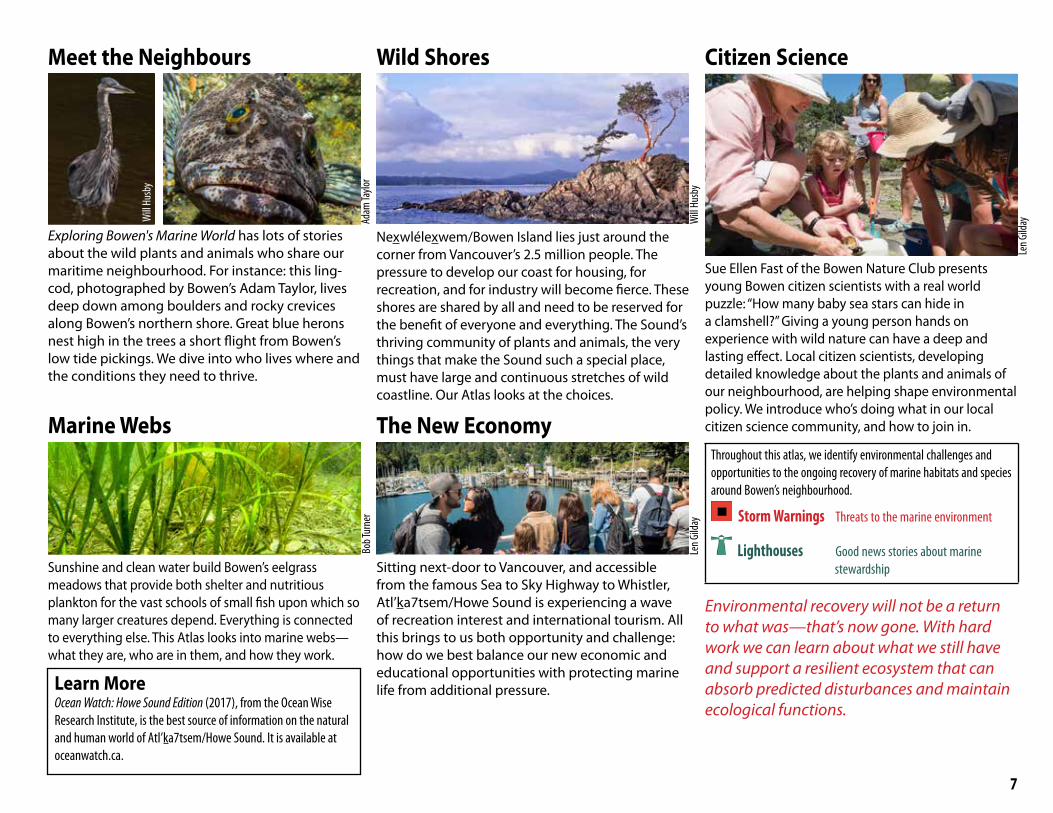
Exploring Bowen's Marine World has lots of stories about the wild plants and animals who share our maritime neighbourhood. For instance: this ling-cod, photographed by Bowen’s Adam Taylor, lives deep down among boulders and rocky crevices along Bowen’s northern shore. Great blue herons nest high in the trees a short flight from Bowen’s low tide pickings. We dive into who lives where and the conditions they need to thrive.
Marine Webs
Sunshine and clean water build Bowen’s eelgrass meadows that provide both shelter and nutritious plankton for the vast schools of small fish upon which so many larger creatures depend. Everything is connected to everything else. This Atlas looks into marine webs—what they are, who are in them, and how they work.
Wild Shores
Nexwlélexwem/Bowen Island lies just around the corner from Vancouver’s 2.5 million people. The pressure to develop our coast for housing, for recreation, and for industry will become fierce. These shores are shared by all and need to be reserved for the benefit of everyone and everything. The Sound’s thriving community of plants and animals, the very things that make the Sound such a special place, must have large and continuous stretches of wild coastline. Our Atlas looks at the choices.
The New Economy
Sitting next-door to Vancouver, and accessible from the famous Sea to Sky Highway to Whistler, Atl’ka7tsem/Howe Sound is experiencing a wave of recreation interest and international tourism. All this brings to us both opportunity and challenge: how do we best balance our new economic and educational opportunities with protecting marine life from additional pressure.
Citizen Science
Sue Ellen Fast of the Bowen Nature Club presents young Bowen citizen scientists with a real world puzzle: “How many baby sea stars can hide in a clamshell?” Giving a young person hands on experience with wild nature can have a deep and lasting effect. Local citizen scientists, developing detailed knowledge about the plants and animals of our neighbourhood, are helping shape environmental policy. We introduce who’s doing what in our local citizen science community, and how to join in.
Throughout this atlas, we identify environmental challenges and opportunities to the ongoing recovery of marine habitats and species around Bowen’s neighbourhood.
Storm Warnings Threats to the marine environment
Lighthouses Good news stories about marine stewardship
Environmental recovery will not be a return to what was—that’s now gone. With hard work we can learn about what we still have and support a resilient ecosystem that can absorb predicted disturbances and maintain ecological functions.
Bob T
urne
r
Will
Husb
y
Len G
ilday
Len G
ilday
Meet the Neighbours
Will
Husb
y
Adam
Taylo
r
Learn MoreOcean Watch: Howe Sound Edition (2017), from the Ocean Wise Research Institute, is the best source of information on the natural and human world of Atl’ka7tsem/Howe Sound. It is available at oceanwatch.ca.
8
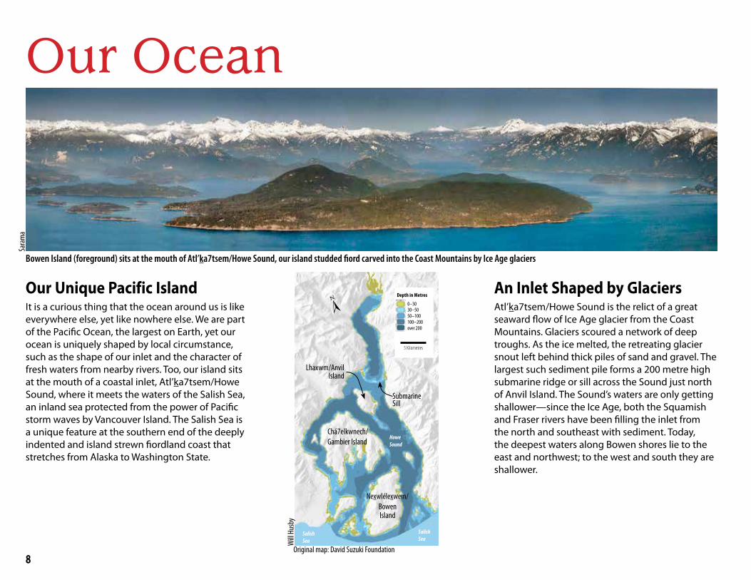
Our OceanSa
ram
a
Bowen Island (foreground) sits at the mouth of Atl’ka7tsem/Howe Sound, our island studded fiord carved into the Coast Mountains by Ice Age glaciers
Our Unique Pacific IslandIt is a curious thing that the ocean around us is like everywhere else, yet like nowhere else. We are part of the Pacific Ocean, the largest on Earth, yet our ocean is uniquely shaped by local circumstance, such as the shape of our inlet and the character of fresh waters from nearby rivers. Too, our island sits at the mouth of a coastal inlet, Atl’ka7tsem/Howe Sound, where it meets the waters of the Salish Sea, an inland sea protected from the power of Pacific storm waves by Vancouver Island. The Salish Sea is a unique feature at the southern end of the deeply indented and island strewn fiordland coast that stretches from Alaska to Washington State.
An Inlet Shaped by Glaciers Atl’ka7tsem/Howe Sound is the relict of a great seaward flow of Ice Age glacier from the Coast Mountains. Glaciers scoured a network of deep troughs. As the ice melted, the retreating glacier snout left behind thick piles of sand and gravel. The largest such sediment pile forms a 200 metre high submarine ridge or sill across the Sound just north of Anvil Island. The Sound’s waters are only getting shallower—since the Ice Age, both the Squamish and Fraser rivers have been filling the inlet from the north and southeast with sediment. Today, the deepest waters along Bowen shores lie to the east and northwest; to the west and south they are shallower.
Howe Sound
0–3030–5050–100100–200over 200
Depth in Metres
5 Kilometres
Will
Husb
y
Original map: David Suzuki Foundation
Nexwlélexwem/Bowen Island
Chá7elkwnech/ Gambier Island
Lhaxwm/AnvilIsland
Submarine Sill
Salish Sea
Salish Sea
[

9
Fertilizing the SoundThe Squamish River flows into Atl’ka7tsem/Howe Sound as a buoyant layer of fresh silty water floating on top of denser ocean water. As this river plume flows south, it slowly mixes with the ocean water below, becoming increasingly salty and less silty towards the mouth of the Sound. Ocean water entrained into the base of this river plume is replaced by a deeper northward flow of ocean
water. Nutrients in both the deep ocean water and the river water fertilize the growth of phytoplankton, a principal foundation of the marine food web in the Sound.
Where River Meets the SeaThe Squamish River flows through a biologically rich wetland delta and spills a muddy plume
into the north end of Atl’ka7tsem/Howe Sound. Since the end of the Ice Age 13,000 years ago, the mouth of the Squamish River has advanced seaward 30 km as it filled the inlet with its
sediment and converted ocean into the Squamish River valley. Today the river mouth continues to advance four metres per year.
2. Our life on an Ocean Island
Bowen Island
Howe Sound
Fraser Plume
Vancouver
Fraser River
Squamish River Plume
Rivers in Our OceanOur inlet is an estuary, a place where river waters mix with the sea and create rich and diverse marine habitats. The satellite image of the Vancouver region (right) shows the silt-laden plumes of the Squamish and Fraser rivers in the north and southeast. These river plumes make our local
ocean less salty than much of the Salish Sea and colour it brown, green, or turquoise depending on the suspended mud or glacial silt they carry. But these fresh water plumes are just thin layers that float above the saltier and denser seawater. Summertime swimmers know this well; often your toes dip below this warm surface layer into surprisingly colder waters below.
Bowen IslandSquamish River
Sill
Bob T
urne
rPh
oto t
aken
on Se
ptem
ber 6
, 201
4 by t
he Ex
pedit
ion 40
crew
of th
e Int
erna
tiona
l Spa
ce St
ation
Will
Husb
y
Salish Sea
Squamish River Estuary
10
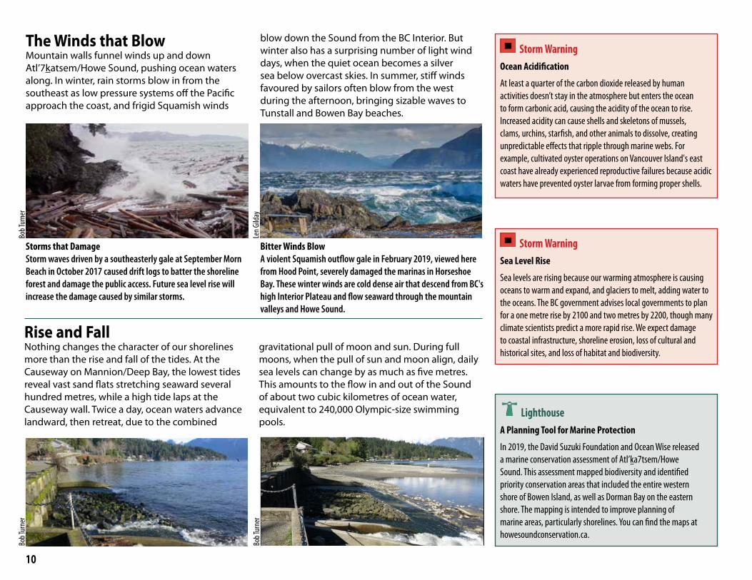
The Winds that BlowMountain walls funnel winds up and down Atl’7katsem/Howe Sound, pushing ocean waters along. In winter, rain storms blow in from the southeast as low pressure systems off the Pacific approach the coast, and frigid Squamish winds
blow down the Sound from the BC Interior. But winter also has a surprising number of light wind days, when the quiet ocean becomes a silver sea below overcast skies. In summer, stiff winds favoured by sailors often blow from the west during the afternoon, bringing sizable waves to Tunstall and Bowen Bay beaches.
Storms that DamageStorm waves driven by a southeasterly gale at September Morn Beach in October 2017 caused drift logs to batter the shoreline forest and damage the public access. Future sea level rise will increase the damage caused by similar storms.
Bitter Winds BlowA violent Squamish outflow gale in February 2019, viewed here from Hood Point, severely damaged the marinas in Horseshoe Bay. These winter winds are cold dense air that descend from BC's high Interior Plateau and flow seaward through the mountain valleys and Howe Sound.
Rise and FallNothing changes the character of our shorelines more than the rise and fall of the tides. At the Causeway on Mannion/Deep Bay, the lowest tides reveal vast sand flats stretching seaward several hundred metres, while a high tide laps at the Causeway wall. Twice a day, ocean waters advance landward, then retreat, due to the combined
gravitational pull of moon and sun. During full moons, when the pull of sun and moon align, daily sea levels can change by as much as five metres. This amounts to the flow in and out of the Sound of about two cubic kilometres of ocean water, equivalent to 240,000 Olympic-size swimming pools.
Storm Warning Ocean Acidification
At least a quarter of the carbon dioxide released by human activities doesn’t stay in the atmosphere but enters the ocean to form carbonic acid, causing the acidity of the ocean to rise. Increased acidity can cause shells and skeletons of mussels, clams, urchins, starfish, and other animals to dissolve, creating unpredictable effects that ripple through marine webs. For example, cultivated oyster operations on Vancouver Island's east coast have already experienced reproductive failures because acidic waters have prevented oyster larvae from forming proper shells.
Storm Warning Sea Level Rise
Sea levels are rising because our warming atmosphere is causing oceans to warm and expand, and glaciers to melt, adding water to the oceans. The BC government advises local governments to plan for a one metre rise by 2100 and two metres by 2200, though many climate scientists predict a more rapid rise. We expect damage to coastal infrastructure, shoreline erosion, loss of cultural and historical sites, and loss of habitat and biodiversity.
Bob T
urne
r
Len G
ilday
Bob T
urne
r
Bob T
urne
r
LighthouseA Planning Tool for Marine Protection
In 2019, the David Suzuki Foundation and Ocean Wise released a marine conservation assessment of Atl’ka7tsem/Howe Sound. This assessment mapped biodiversity and identified priority conservation areas that included the entire western shore of Bowen Island, as well as Dorman Bay on the eastern shore. The mapping is intended to improve planning of marine areas, particularly shorelines. You can find the maps at howesoundconservation.ca.

11
How Our Island Came To BeBowen Wasn’t Always an Island!Try to imagine the mountains of Bowen not as surrounded by ocean, but rather as hills within a forested river valley far from the coast. Before the Ice Age (two million to 13,000 years ago), the BC coast was not the highly convolute one we know today, but rather a straight one similar to the present coasts of Oregon and California. At that time, what is now Atl’ka7tsem/Howe Sound and the Salish Sea were river valleys well inland from the coast. But the Ice Age glaciers scoured these valleys deeply, and when the ice retreated, they were flooded by the ocean, creating the coastline we know today.
Two Kilometres of Grinding GlacierHow thick were the glaciers in Howe Sound at the peak of the Ice Age? Conveniently, the answer is written in the shape of our local mountains. Only the highest peaks, such as the Tantalus Range, poked above these glaciers and so retained their craggy shape. Lower peaks and islands were over-ridden by glaciers and rounded by the grinding force of rock debris that they dragged along.
Bowen IslandsAs the Ice Age glaciers retreated, they left behind not one, but at least three, Bowen Islands. The weight of the glaciers had depressed the Earth’s crust into the underlying Earth’s mantle, and so when the glaciers retreated, sea level was 150 metres higher than it is today. Only our three mountains stood above the ocean, each as an island. Slowly the land rebounded, and gradually sea level fell to its present position. But for several thousand years, the lower slopes of Bowen Island were a sand and mud/clay seafloor, home to all sorts of life.
Life from an Ancient SeafloorYou can find ancient seafloor clams, snails and worm tubes in clay deposits at lower elevations around Bowen Island. In the 1980s, Roy Bolton found a 12,500 year old sea lion bone while dig-ging a well into hard pan clay on his property near Killarney Lake.
Bob T
urne
r
Bob T
urne
r
Bowen Island 12,500 Years Ago
Collins Island
Gardner Island
Apodaca Island
KIllarney ChannelGrafton
Channel
Sea Lion Bones
Fossils in Clay
Present Shoreline
Before the Ice Age
During the Ice Age
Today
Pacific Ocean
Pacific Ocean
Pacific Ocean
Salish Valley
Location of future Bowen Island
Location of future Bowen Island
Bowen Island
Salish Sea
Bob T
urne
r and
Will
Husb
y
Bob T
urne
r and
Will
Husb
y
12
Skwxwú7mesh Úxwumixw
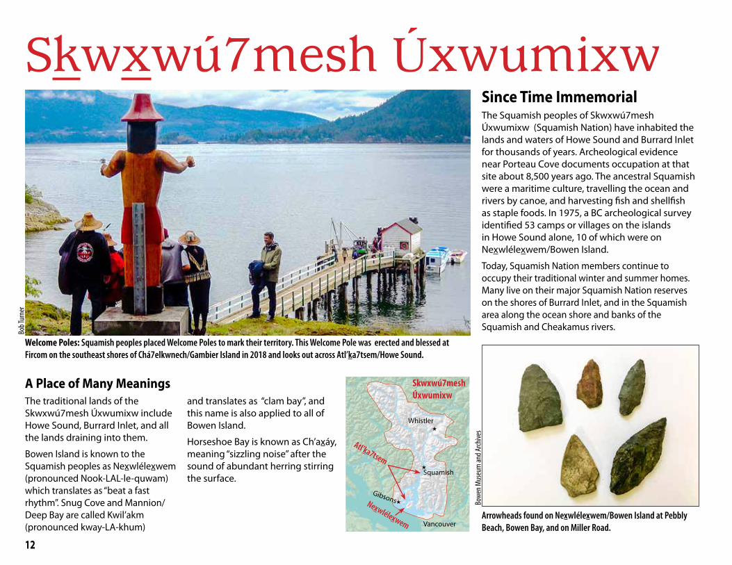
Welcome Poles: Squamish peoples placed Welcome Poles to mark their territory. This Welcome Pole was erected and blessed at Fircom on the southeast shores of Chá7elkwnech/Gambier Island in 2018 and looks out across Atl’ka7tsem/Howe Sound.
A Place of Many MeaningsThe traditional lands of the Skwxwú7mesh Úxwumixw include Howe Sound, Burrard Inlet, and all the lands draining into them.
Bowen Island is known to the Squamish peoples as Nexwlélexwem (pronounced Nook-LAL-le-quwam) which translates as “beat a fast rhythm”. Snug Cove and Mannion/Deep Bay are called Kwil’akm (pronounced kway-LA-khum)
and translates as “clam bay”, and this name is also applied to all of Bowen Island.
Horseshoe Bay is known as Ch’axáy, meaning “sizzling noise” after the sound of abundant herring stirring the surface.
Since Time ImmemorialThe Squamish peoples of Skwxwú7mesh Úxwumixw (Squamish Nation) have inhabited the lands and waters of Howe Sound and Burrard Inlet for thousands of years. Archeological evidence near Porteau Cove documents occupation at that site about 8,500 years ago. The ancestral Squamish were a maritime culture, travelling the ocean and rivers by canoe, and harvesting fish and shellfish as staple foods. In 1975, a BC archeological survey identified 53 camps or villages on the islands in Howe Sound alone, 10 of which were on Nexwlélexwem/Bowen Island.
Today, Squamish Nation members continue to occupy their traditional winter and summer homes. Many live on their major Squamish Nation reserves on the shores of Burrard Inlet, and in the Squamish area along the ocean shore and banks of the Squamish and Cheakamus rivers.
Arrowheads found on Nexwlélexwem/Bowen Island at Pebbly Beach, Bowen Bay, and on Miller Road.
Bowe
n Mus
eum
and A
rchive
s
Skwxwú7mesh Úxwumixw
Nexwlélexwem
Atl’ka7tsem
Gibsons
Vancouver
Squamish
Whistler
Bob T
urne
r

13
A Spirit of SharingToday elders and other community leaders maintain and share Skwxwú7mesh culture.
Squamish Nation members Xwalacktun (left), an internation-ally recognized carver, and S7aplek, co-founder of Spakwus
Slulum Dance Troupe, at a Knowing our Place event at the Gallery in Artisan Square in 2017.
Cath
y Bay
ly
Squamish peoples made different canoes for differ-ent purposes. Massive canoes up to 20 metres long had a platform on the bow to harpoon sea lions and whales. Smaller ocean-going canoes were used for seal hunting and fishing. Shovelnose or river canoes were used to pole up rivers, and women used small
Learn MoreSquamishAtlas.com has an interactive map showing the locations of villages and landmarks.
Squamish Lil’wat Cultural Centre, Where Rivers Mountains and People Meet. Spo7ez Cultural Centre and Community Society, 2010.
Conversations with Khahtsahlano 1932-1954, compiled by Major J. S. Matthews, V.D. City Archivist, City Hall, Vancouver, 1955
Stories of How It WasInsights into the traditional ways of the Squamish peo-ples, and marine life in the late 1800s is recorded in the conversations between August Jack Khahtsahlano and the Vancouver City archivist, between 1934 and 1954:
Squamish their home; lots salmon, deer, beaver. In the summer time they go down English Bay and Burrard Inlet to get small fish, smelts, herring, oolichans, and dry
them, and get clams, get berries, lots summer food down Burrard Inlet. Duck easier to get at English Bay than Squamish. Indian catch duck at night, spear them …
No sea otter in English Bay, nor Howe Sound; just seal, lots of seal. Squamish go seal hunting in canoe. Seal sleeping on surface; just under surface; sneak up spear him.
Len G
ilday
The Squamish Seagoing Canoe Family arrives in Snug Cove for the Voices in the Sound Festival, July 2006. The Squamish have two names for Howe Sound. If paddling south toward the Salish Sea, they call it Atl’ka7tsem (pronounced AT-ka-tsoom) and when pad-dling north toward Squamish, it is called Txwnewu7ts’ (pronounced Chuck-Now-Its).
Will
Husb
y
A Canoe Peoples
one or two-person canoes to gather shellfish and navigate the side channels of rivers when gathering plants, berries, and medicines.
Nexwlélexwem/Bowen Island was important to the Squamish peoples for clam harvesting and hunting sea lion and whales.
This ancient scar on a cedar tree in Crippen Park may reflect cedar bark harvesting by Squamish peoples. Cedar bark had many uses, including rope for tying canoes and attaching harpoons used for hunting seals, sea lions, whales, and sturgeon.
Jacq
uelin
e Mas
sey
14
Modern Human Impacts
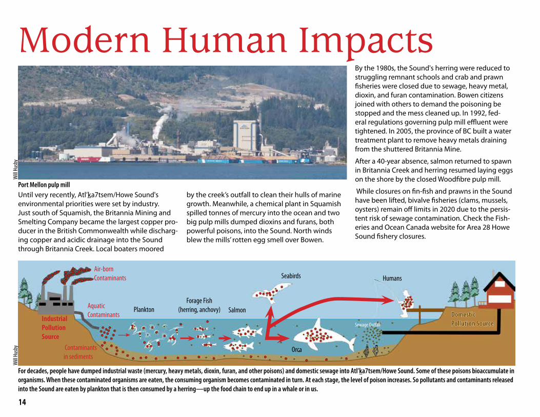
Until very recently, Atl’ka7tsem/Howe Sound's environmental priorities were set by industry. Just south of Squamish, the Britannia Mining and Smelting Company became the largest copper pro-ducer in the British Commonwealth while discharg-ing copper and acidic drainage into the Sound through Britannia Creek. Local boaters moored
by the creek’s outfall to clean their hulls of marine growth. Meanwhile, a chemical plant in Squamish spilled tonnes of mercury into the ocean and two big pulp mills dumped dioxins and furans, both powerful poisons, into the Sound. North winds blew the mills’ rotten egg smell over Bowen.
By the 1980s, the Sound's herring were reduced to struggling remnant schools and crab and prawn fisheries were closed due to sewage, heavy metal, dioxin, and furan contamination. Bowen citizens joined with others to demand the poisoning be stopped and the mess cleaned up. In 1992, fed-eral regulations governing pulp mill effluent were tightened. In 2005, the province of BC built a water treatment plant to remove heavy metals draining from the shuttered Britannia Mine.
After a 40-year absence, salmon returned to spawn in Britannia Creek and herring resumed laying eggs on the shore by the closed Woodfibre pulp mill.
While closures on fin-fish and prawns in the Sound have been lifted, bivalve fisheries (clams, mussels, oysters) remain off limits in 2020 due to the persis-tent risk of sewage contamination. Check the Fish-eries and Ocean Canada website for Area 28 Howe Sound fishery closures.
Port Mellon pulp mill
For decades, people have dumped industrial waste (mercury, heavy metals, dioxin, furan, and other poisons) and domestic sewage into Atl’ka7tsem/Howe Sound. Some of these poisons bioaccumulate in organisms. When these contaminated organisms are eaten, the consuming organism becomes contaminated in turn. At each stage, the level of poison increases. So pollutants and contaminants released into the Sound are eaten by plankton that is then consumed by a herring—up the food chain to end up in a whale or in us.
Industrial Pollution Source
Air-bornContaminants
Aquatic Contaminants
Contaminantsin sediments
PlanktonForage Fish
(herring, anchovy) Salmon
Orca
Seabirds Humans
Will
Husb
yW
ill Hu
sby
Domestic Domestic Pollution SourcePollution SourceSewage Outfall
15
Lighthouse Fighting Pollution from DocksStyrofoam used in single-use food containers and to float docks can be lethal to marine life. Small, round bits of foam resemble fish eggs—a staple food for many marine creatures. When fish and waterfowl swallow them they can clog their intestines, leading to starvation. The better move is to avoid use of foam in food
containers and dock floats.
Sometimes doing what you can makes all the difference. When Karen Cowper looked out her Grafton Bay window after a 2019 winter storm, she discovered a mass of styrofoam on the beach below—wreckage from a large dock carried in by the storm. Karen filled and hauled away 200 contractor-size bags of styrofoam chips and debris. Her quick response saved lives.
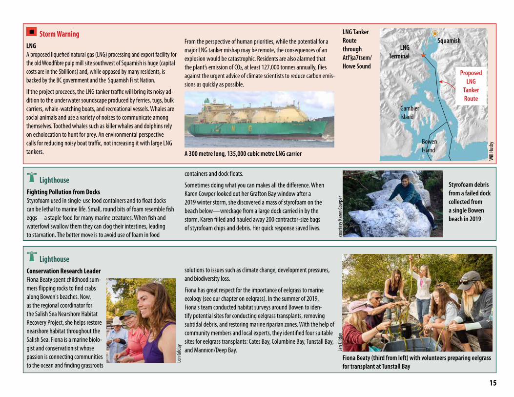
Storm Warning LNGA proposed liquefied natural gas (LNG) processing and export facility for the old Woodfibre pulp mill site southwest of Squamish is huge (capital costs are in the $billions) and, while opposed by many residents, is backed by the BC government and the Squamish First Nation.
If the project proceeds, the LNG tanker traffic will bring its noisy ad-dition to the underwater soundscape produced by ferries, tugs, bulk carriers, whale-watching boats, and recreational vessels. Whales are social animals and use a variety of noises to communicate among themselves. Toothed whales such as killer whales and dolphins rely on echolocation to hunt for prey. An environmental perspective calls for reducing noisy boat traffic, not increasing it with large LNG tankers.
From the perspective of human priorities, while the potential for a major LNG tanker mishap may be remote, the consequences of an explosion would be catastrophic. Residents are also alarmed that the plant’s emission of CO2, at least 127,000 tonnes annually, flies against the urgent advice of climate scientists to reduce carbon emis-sions as quickly as possible.
A 300 metre long, 135,000 cubic metre LNG carrier
LNG Tanker Route through Atl’ka7tsem/Howe Sound
Bowen Island
Gambier Island
LNG Terminal
cour
tesy
Kare
n Cow
per
LighthouseConservation Research LeaderFiona Beaty spent childhood sum-mers flipping rocks to find crabs along Bowen's beaches. Now, as the regional coordinator for the Salish Sea Nearshore Habitat Recovery Project, she helps restore nearshore habitat throughout the Salish Sea. Fiona is a marine biolo-gist and conservationist whose passion is connecting communities to the ocean and finding grassroots
solutions to issues such as climate change, development pressures, and biodiversity loss.
Fiona has great respect for the importance of eelgrass to marine ecology (see our chapter on eelgrass). In the summer of 2019, Fiona's team conducted habitat surveys around Bowen to iden-tify potential sites for conducting eelgrass transplants, removing subtidal debris, and restoring marine riparian zones. With the help of community members and local experts, they identified four suitable sites for eelgrass transplants: Cates Bay, Columbine Bay, Tunstall Bay, and Mannion/Deep Bay.
Fiona Beaty (third from left) with volunteers preparing eelgrass for transplant at Tunstall Bay
Styrofoam debris from a failed dock collected from a single Bowen beach in 2019
Len G
ilday
Will
Husb
y
Len G
ilday
Squamish
Proposed LNG
Tanker Route
16
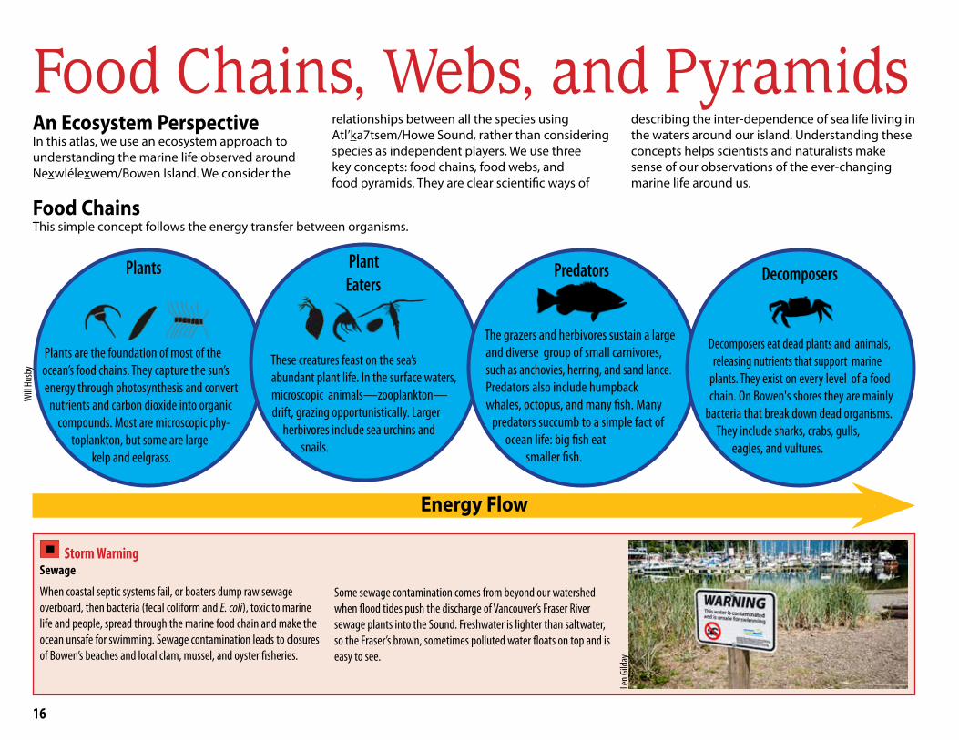
Food Chains, Webs, and PyramidsAn Ecosystem PerspectiveIn this atlas, we use an ecosystem approach to understanding the marine life observed around Nexwlélexwem/Bowen Island. We consider the
relationships between all the species using Atl’ka7tsem/Howe Sound, rather than considering species as independent players. We use three key concepts: food chains, food webs, and food pyramids. They are clear scientific ways of
describing the inter-dependence of sea life living in the waters around our island. Understanding these concepts helps scientists and naturalists make sense of our observations of the ever-changing marine life around us.
Food ChainsThis simple concept follows the energy transfer between organisms.
Energy Flow
Storm Warning Sewage
When coastal septic systems fail, or boaters dump raw sewage overboard, then bacteria (fecal coliform and E. coli), toxic to marine life and people, spread through the marine food chain and make the ocean unsafe for swimming. Sewage contamination leads to closures of Bowen’s beaches and local clam, mussel, and oyster fisheries.
Some sewage contamination comes from beyond our watershed when flood tides push the discharge of Vancouver’s Fraser River sewage plants into the Sound. Freshwater is lighter than saltwater, so the Fraser’s brown, sometimes polluted water floats on top and is easy to see.
Plants
Plants are the foundation of most of the ocean’s food chains. They capture the sun’s energy through photosynthesis and convert
nutrients and carbon dioxide into organic compounds. Most are microscopic phy-
toplankton, but some are large kelp and eelgrass.
Plant Eaters
These creatures feast on the sea’s abundant plant life. In the surface waters,
microscopic animals—zooplankton—drift, grazing opportunistically. Larger
herbivores include sea urchins and snails.
Predators
The grazers and herbivores sustain a large and diverse group of small carnivores,
such as anchovies, herring, and sand lance. Predators also include humpback
whales, octopus, and many fish. Many predators succumb to a simple fact of
ocean life: big fish eat smaller fish.
Decomposers
Decomposers eat dead plants and animals, releasing nutrients that support marine plants. They exist on every level of a food chain. On Bowen's shores they are mainly
bacteria that break down dead organisms. They include sharks, crabs, gulls,
eagles, and vultures.
Len G
ilday
Will
Husb
y
17
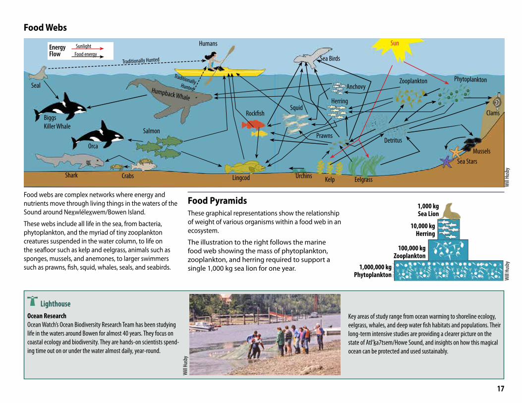
Food Webs
Food webs are complex networks where energy and nutrients move through living things in the waters of the Sound around Nexwlélexwem/Bowen Island.
These webs include all life in the sea, from bacteria, phytoplankton, and the myriad of tiny zooplankton creatures suspended in the water column, to life on the seafloor such as kelp and eelgrass, animals such as sponges, mussels, and anemones, to larger swimmers such as prawns, fish, squid, whales, seals, and seabirds.
Food Pyramids These graphical representations show the relationship of weight of various organisms within a food web in an ecosystem.
The illustration to the right follows the marine food web showing the mass of phytoplankton, zooplankton, and herring required to support a single 1,000 kg sea lion for one year.
LighthouseOcean ResearchOcean Watch’s Ocean Biodiversity Research Team has been studying life in the waters around Bowen for almost 40 years. They focus on coastal ecology and biodiversity. They are hands-on scientists spend-ing time out on or under the water almost daily, year-round.
Key areas of study range from ocean warming to shoreline ecology, eelgrass, whales, and deep water fish habitats and populations. Their long-term intensive studies are providing a clearer picture on the state of Atl’ka7tsem/Howe Sound, and insights on how this magical ocean can be protected and used sustainably.
1,000,000 kgPhytoplankton
100,000 kgZooplankton
10,000 kgHerring
1,000 kgSea Lion
Seal
Humans
Orca
Shark Crabs
Salmon
Sea Birds
Urchins Kelp Eelgrass
Sea StarsMussels
Clams
Prawns
Phytoplankton
Detritus
Humpback Whale
Zooplankton
Will
Husb
y
Will
Husb
yW
ill Hu
sby
BiggsKiller Whale
Lingcod
RockfishSquid
Anchovy
Herring
Energy Flow
SunlightFood energy
Sun
Traditionally Hunted
Traditionally Hunted
18
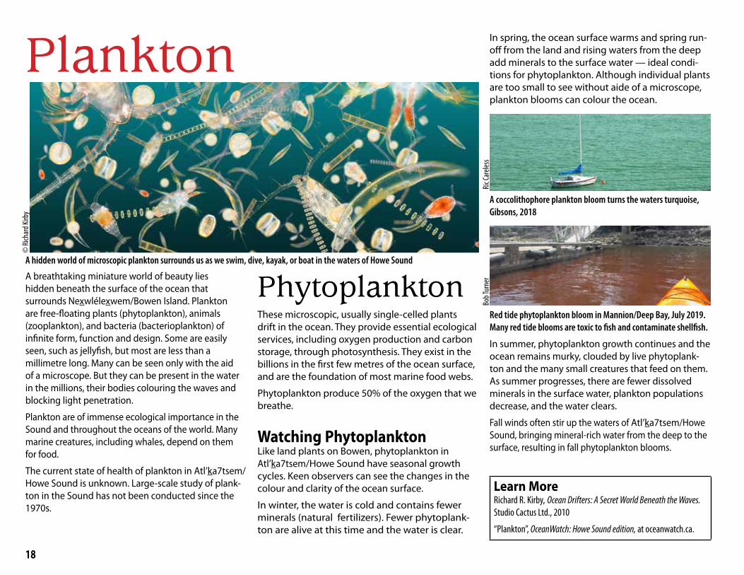
Plankton©
Rich
ard K
irby
A hidden world of microscopic plankton surrounds us as we swim, dive, kayak, or boat in the waters of Howe Sound
A breathtaking miniature world of beauty lies hidden beneath the surface of the ocean that surrounds Nexwlélexwem/Bowen Island. Plankton are free-floating plants (phytoplankton), animals (zooplankton), and bacteria (bacterioplankton) of infinite form, function and design. Some are easily seen, such as jellyfish, but most are less than a millimetre long. Many can be seen only with the aid of a microscope. But they can be present in the water in the millions, their bodies colouring the waves and blocking light penetration.
Plankton are of immense ecological importance in the Sound and throughout the oceans of the world. Many marine creatures, including whales, depend on them for food.
The current state of health of plankton in Atl’ka7tsem/Howe Sound is unknown. Large-scale study of plank-ton in the Sound has not been conducted since the 1970s.
These microscopic, usually single-celled plants drift in the ocean. They provide essential ecological services, including oxygen production and carbon storage, through photosynthesis. They exist in the billions in the first few metres of the ocean surface, and are the foundation of most marine food webs.
Phytoplankton produce 50% of the oxygen that we breathe.
Watching PhytoplanktonLike land plants on Bowen, phytoplankton in Atl’ka7tsem/Howe Sound have seasonal growth cycles. Keen observers can see the changes in the colour and clarity of the ocean surface.
In winter, the water is cold and contains fewer minerals (natural fertilizers). Fewer phytoplank-ton are alive at this time and the water is clear.
Phytoplankton
In spring, the ocean surface warms and spring run-off from the land and rising waters from the deep add minerals to the surface water — ideal condi-tions for phytoplankton. Although individual plants are too small to see without aide of a microscope, plankton blooms can colour the ocean.
A coccolithophore plankton bloom turns the waters turquoise, Gibsons, 2018
Red tide phytoplankton bloom in Mannion/Deep Bay, July 2019. Many red tide blooms are toxic to fish and contaminate shellfish.
In summer, phytoplankton growth continues and the ocean remains murky, clouded by live phytoplank-ton and the many small creatures that feed on them. As summer progresses, there are fewer dissolved minerals in the surface water, plankton populations decrease, and the water clears.
Fall winds often stir up the waters of Atl’ka7tsem/Howe Sound, bringing mineral-rich water from the deep to the surface, resulting in fall phytoplankton blooms.
Learn MoreRichard R. Kirby, Ocean Drifters: A Secret World Beneath the Waves. Studio Cactus Ltd., 2010
“Plankton”, OceanWatch: Howe Sound edition, at oceanwatch.ca.
Bob T
urne
rRi
c Car
eless
19
Distribution of Phytoplankton in Howe Sound
Studies in the 1970s showed lowest phytoplankton populations near the mouth of the Squamish River and highest populations around Bowen Island and areas near the mouth of the Sound.
Lowest
Highest
Phyt
opla
nkto
n De
nsity
Zooplankton
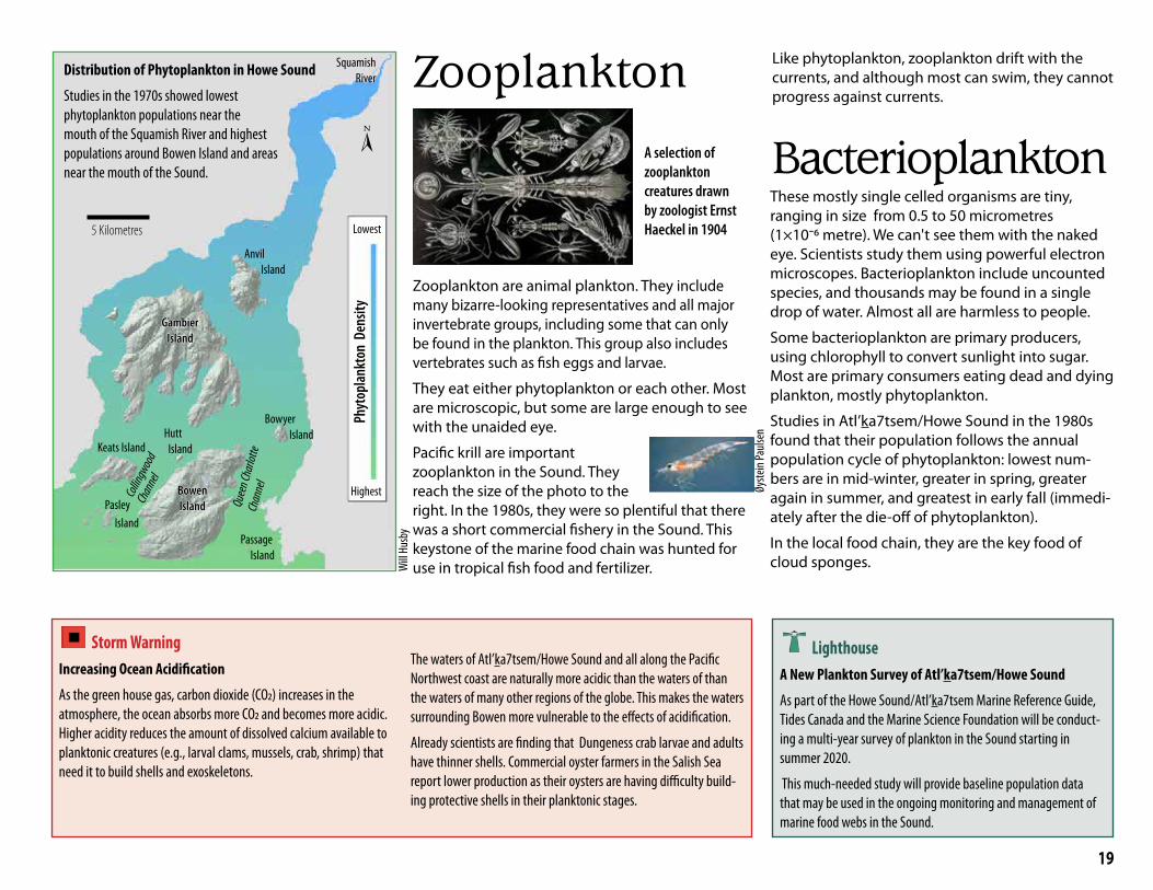
Zooplankton are animal plankton. They include many bizarre-looking representatives and all major invertebrate groups, including some that can only be found in the plankton. This group also includes vertebrates such as fish eggs and larvae.
They eat either phytoplankton or each other. Most are microscopic, but some are large enough to see with the unaided eye.
Pacific krill are important zooplankton in the Sound. They reach the size of the photo to the right. In the 1980s, they were so plentiful that there was a short commercial fishery in the Sound. This keystone of the marine food chain was hunted for use in tropical fish food and fertilizer.
Storm WarningIncreasing Ocean Acidification
As the green house gas, carbon dioxide (CO2) increases in the atmosphere, the ocean absorbs more CO2 and becomes more acidic. Higher acidity reduces the amount of dissolved calcium available to planktonic creatures (e.g., larval clams, mussels, crab, shrimp) that need it to build shells and exoskeletons.
The waters of Atl’ka7tsem/Howe Sound and all along the Pacific Northwest coast are naturally more acidic than the waters of than the waters of many other regions of the globe. This makes the waters surrounding Bowen more vulnerable to the effects of acidification.
Already scientists are finding that Dungeness crab larvae and adults have thinner shells. Commercial oyster farmers in the Salish Sea report lower production as their oysters are having difficulty build-ing protective shells in their planktonic stages.
Like phytoplankton, zooplankton drift with the currents, and although most can swim, they cannot progress against currents.
Lighthouse A New Plankton Survey of Atl’ka7tsem/Howe Sound
As part of the Howe Sound/Atl’ka7tsem Marine Reference Guide, Tides Canada and the Marine Science Foundation will be conduct-ing a multi-year survey of plankton in the Sound starting in summer 2020.
This much-needed study will provide baseline population data that may be used in the ongoing monitoring and management of marine food webs in the Sound.
Will
Husb
y
A selection of zooplankton creatures drawn by zoologist Ernst Haeckel in 1904
Øyste
in Pa
ulsen
BacterioplanktonThese mostly single celled organisms are tiny, ranging in size from 0.5 to 50 micrometres (1×10⁻⁶ metre). We can't see them with the naked eye. Scientists study them using powerful electron microscopes. Bacterioplankton include uncounted species, and thousands may be found in a single drop of water. Almost all are harmless to people.
Some bacterioplankton are primary producers, using chlorophyll to convert sunlight into sugar. Most are primary consumers eating dead and dying plankton, mostly phytoplankton.
Studies in Atl’ka7tsem/Howe Sound in the 1980s found that their population follows the annual population cycle of phytoplankton: lowest num-bers are in mid-winter, greater in spring, greater again in summer, and greatest in early fall (immedi-ately after the die-off of phytoplankton).
In the local food chain, they are the key food of cloud sponges.
Squamish River
Anvil Island
Gambier Gambier IslandIsland
BowenBowenIslandIsland
BowyerIsland
Keats IslandHutt Island
Passage Island
Pasley Island
Quee
n Cha
rlotte
Ch
anne
l
Collin
gwoo
d Ch
anne
l[
5 Kilometres
20
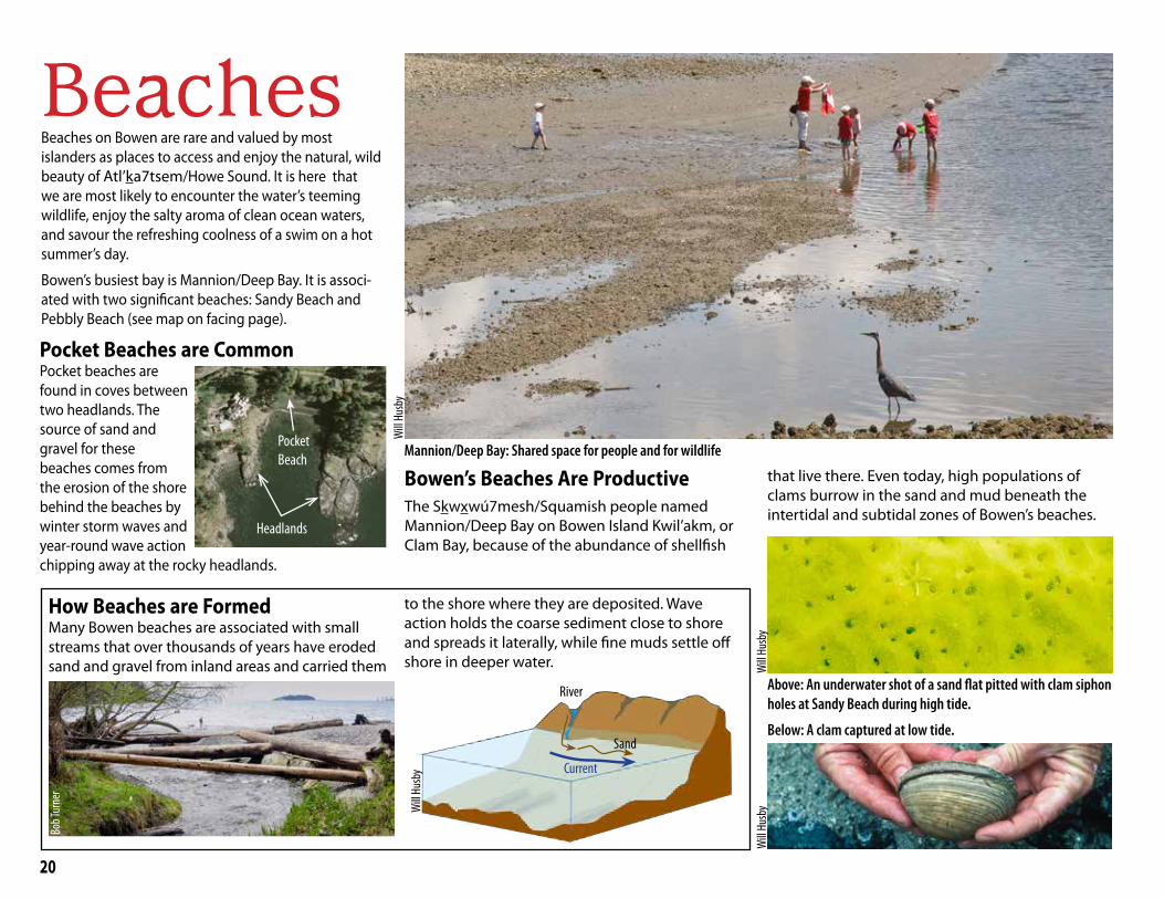
BeachesBeaches on Bowen are rare and valued by most islanders as places to access and enjoy the natural, wild beauty of Atl’ka7tsem/Howe Sound. It is here that we are most likely to encounter the water’s teeming wildlife, enjoy the salty aroma of clean ocean waters, and savour the refreshing coolness of a swim on a hot summer’s day.
Bowen’s busiest bay is Mannion/Deep Bay. It is associ-ated with two significant beaches: Sandy Beach and Pebbly Beach (see map on facing page).
Mannion/Deep Bay: Shared space for people and for wildlife
Pocket Beaches are Common Pocket beaches are found in coves between two headlands. The source of sand and gravel for these beaches comes from the erosion of the shore behind the beaches by winter storm waves and year-round wave action chipping away at the rocky headlands.
Headlands
Pocket Beach
How Beaches are FormedMany Bowen beaches are associated with small streams that over thousands of years have eroded sand and gravel from inland areas and carried them
to the shore where they are deposited. Wave action holds the coarse sediment close to shore and spreads it laterally, while fine muds settle off shore in deeper water.
Current
Sand
River
Bowen’s Beaches Are ProductiveThe Skwxwú7mesh/Squamish people named Mannion/Deep Bay on Bowen Island Kwil’akm, or Clam Bay, because of the abundance of shellfish
that live there. Even today, high populations of clams burrow in the sand and mud beneath the intertidal and subtidal zones of Bowen’s beaches.
Above: An underwater shot of a sand flat pitted with clam siphon holes at Sandy Beach during high tide.
Below: A clam captured at low tide.
Will
Husb
y
Will
Husb
yW
ill Hu
sby
Bob T
urne
r
Will
Husb
y
21
Eagle Cliff
Sandy Beach (C)
Cape Roger Curtis Beach (C)
Tunstall Bay
Bowen Bay
Cates Bay
Bishop's
Baker
Pebbly Beach (N)
September Morn
Seymour Bay
Alder Cove Beach (N)
Lighthouse Lane
King Edward Bay
Clipper Place
Crayola
Woods Road
Beach (N)
Beach (N)
Beach (N)
Beach (N)
Beach (N)
Beach (N)Beach (N)
Beach (N)
Beach (N)
Beach (N)
Beach (N)
Beach (C)
Beach (C)
Crippen Regional Park
Ecological Reserve
Snug Cove
Mannion/Deep Bay
Cates Bay
Tunstall Bay
Bowen Bay
Grafton Bay
Seymour Bay
Cape Roger Curtis
Cowan Point
BBlluueewwaatteerrGrafton
Lake
KillarneyLake
Bluewater
Queen Charlotte Heights
CowanPoint
SnugCove
EagleCliff
Hood Point
MountGardner
ApodacaProvincial Park
TunstallBay
Josephine Lake
Crown Land
Millers Landing
Fairweather
Hood Point West
Passage Island
Worlcombe Island
Pasley Island
Keats Island
Hutt Island
Ferry
Columbine Bay
Dorman Bay
Onion Island
Sand and Pebble
Boulder and Cobble
Community Beach(larger, with some facilities)
Neighbourhood Beach (smaller, with limited facilities)
(C)
(N)
Beaches
0 1 2
Kilometres
[
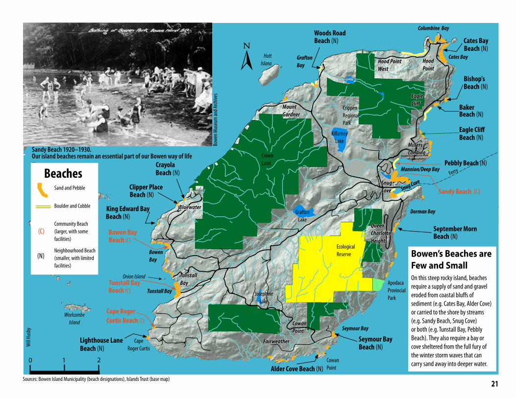
Bowen’s Beaches are Few and SmallOn this steep rocky island, beaches require a supply of sand and gravel eroded from coastal bluffs of sediment (e.g. Cates Bay, Alder Cove) or carried to the shore by streams (e.g. Sandy Beach, Snug Cove) or both (e.g. Tunstall Bay, Pebbly Beach). They also require a bay or cove sheltered from the full fury of the winter storm waves that can carry sand away into deeper water.
Sandy Beach 1920–1930. Our island beaches remain an essential part of our Bowen way of life
Will
Husb
y
Sources: Bowen Island Municipality (beach designations), Islands Trust (base map)
Bowe
n Mus
eum
and A
rchive
s
22
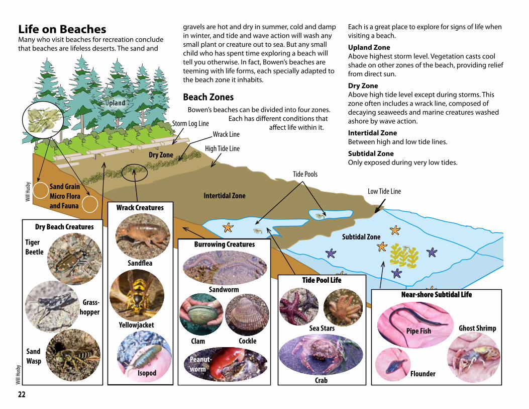
Life on Beaches
ClipboardPageNumberb
b
RRRb
Upland
Dry Zone
Intertidal Zone
Subtidal Zone
Storm Log Line
High Tide Line
Low Tide Line
Tide Pools
Wrack Line
Many who visit beaches for recreation conclude that beaches are lifeless deserts. The sand and
gravels are hot and dry in summer, cold and damp in winter, and tide and wave action will wash any small plant or creature out to sea. But any small child who has spent time exploring a beach will tell you otherwise. In fact, Bowen’s beaches are teeming with life forms, each specially adapted to the beach zone it inhabits.
Beach ZonesBowen’s beaches can be divided into four zones.
Each has different conditions that affect life within it.
Each is a great place to explore for signs of life when visiting a beach.
Upland ZoneAbove highest storm level. Vegetation casts cool shade on other zones of the beach, providing relief from direct sun.
Dry Zone Above high tide level except during storms. This zone often includes a wrack line, composed of decaying seaweeds and marine creatures washed ashore by wave action.
Intertidal Zone Between high and low tide lines.
Subtidal Zone Only exposed during very low tides.
Sand Grain Micro Flora and Fauna Wrack Creatures
Burrowing CreaturesBurrowing Creatures
Tide Pool LifeTide Pool Life
Near-shore Subtidal LifeNear-shore Subtidal Life
SandfleaSandflea
YellowjacketYellowjacket
Clam
Sandworm
Peanut-worm
Crab
Sea Stars Pipe Fish
Flounder
Ghost Shrimp
Dry Beach Creatures
Tiger Beetle
Grass-Grass-hopperhopper
Isopod
Sand Wasp
Will
Husb
y
Will
Husb
y
Cockle
23
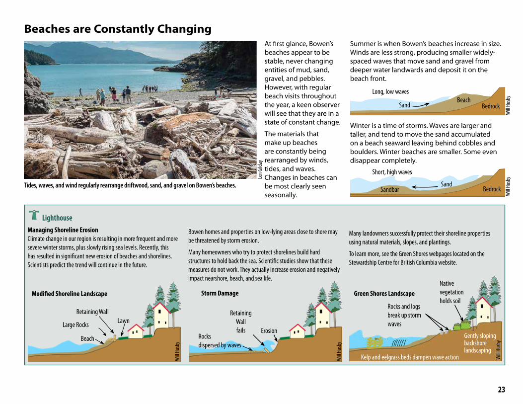
Tides, waves, and wind regularly rearrange driftwood, sand, and gravel on Bowen’s beaches.
At first glance, Bowen’s beaches appear to be stable, never changing entities of mud, sand, gravel, and pebbles. However, with regular beach visits throughout the year, a keen observer will see that they are in a state of constant change.
The materials that make up beaches are constantly being rearranged by winds, tides, and waves. Changes in beaches can be most clearly seen seasonally.
Summer is when Bowen’s beaches increase in size. Winds are less strong, producing smaller widely-spaced waves that move sand and gravel from deeper water landwards and deposit it on the beach front.
Long, low waves
SandBeach
Bedrock
Winter is a time of storms. Waves are larger and taller, and tend to move the sand accumulated on a beach seaward leaving behind cobbles and boulders. Winter beaches are smaller. Some even disappear completely.
Short, high waves
SandbarSand
Bedrock
LighthouseManaging Shoreline ErosionClimate change in our region is resulting in more frequent and more severe winter storms, plus slowly rising sea levels. Recently, this has resulted in significant new erosion of beaches and shorelines. Scientists predict the trend will continue in the future.
Bowen homes and properties on low-lying areas close to shore may be threatened by storm erosion.
Many homeowners who try to protect shorelines build hard structures to hold back the sea. Scientific studies show that these measures do not work. They actually increase erosion and negatively impact nearshore, beach, and sea life.
Many landowners successfully protect their shoreline properties using natural materials, slopes, and plantings.
To learn more, see the Green Shores webpages located on the Stewardship Centre for British Columbia website.
Beaches are Constantly Changing
Modified Shoreline Landscape
Len G
ilday
Will
Husb
y
Green Shores Landscape
Rocks and logs break up storm waves
Native vegetation holds soil
Gently sloping backshore landscaping
Kelp and eelgrass beds dampen wave action
Large Rocks
Retaining Wall
Beach
Lawn
Storm Damage
Retaining Wall fails
Rocksdispersed by waves
ErosionW
ill Hu
sby
Will
Husb
y
Will
Husb
y
Will
Husb
y
24
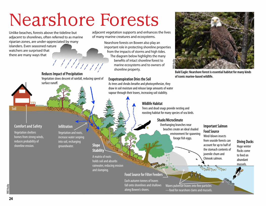
Nearshore ForestsUnlike beaches, forests above the tideline but adjacent to shorelines, often referred to as marine riparian zones, are under-appreciated by many islanders. Even seasoned nature watchers are surprised that there are many ways that
adjacent vegetation supports and enhances the lives of many marine creatures and ecosystems.
Nearshore forests on Bowen also play an important role in protecting shoreline properties from the impacts of storms and high tides. The diagram below highlights the many benefits of intact shoreline forest to marine ecosystems and to owners of shoreline property.
Slope StabilityA matrix of roots holds soil and absorbs rainwater, reducing erosion and slumping.
InfiltrationVegetation and roots, increase water seeping into soil, recharging groundwater.
Soil
Reduces Impact of Precipitation Vegetation slows descent of rainfall, reducing speed of surface runoff.
Evapotranspiration Dries the Soil As trees and shrubs breathe and photosynthesize, they draw in soil moisture and release large amounts of water vapour through their leaves, increasing soil stability.
Wildlife Habitat Trees and dead snags provide nesting and roosting habitat for many species of sea birds.
Important Salmon Food SourceWind-blown insects from seaside forests can account for up to half of the stomach contents of juvenile chum and Chinook salmon.
Food Source for Filter FeedersEach autumn tonnes of leaves fall onto shorelines and shallows along Bowen’s shores.
Waves pulverize leaves into fine particles —food for nearshore clams and mussels.
Comfort and SafetyVegetation shelters homes from strong winds, reduces probability of shoreline erosion.
Will
Husb
y
Diving Ducks Huge winter flocks come to feed on abundant mussels.
Bald Eagle: Nearshore forest is essential habitat for many kinds of iconic marine-based wildlife.
Will
Husb
y
Shade/MicroclimateOverhanging branches near
beaches create an ideal shaded environment for spawning
forage fish eggs.

25
Snug Cove, Crippen Park: Intact beach and steep cliff shoreline forest in autumn. Wave and tidal action grind autumn leaf-fall into small particles—ideal food for marine filter feeders such as clams, mussels, and ghost shrimp. This occurs at a time when their summer food supply (plankton) is naturally declining.
Storm Warning Lose, Lose: When Nature and Homeowners are Both Hurt
LighthouseLiving with Nature: Protecting Your Property while Promoting Healthy Shorelines
The Stewardship Centre for BC’s Green Shore Program provides guides to homeowners for understanding and protecting your shoreline forest and supporting its many ecological functions.
Your Marine Waterfront
Enjoy the beach. Protect your home. Improve shoreline habitat.
CANADIAN EDITION
A guide to protecting your property while promoting healthy shorelines
You can download this guide and many more helpful documents from the Greens Shores website.
Will
Husb
y
Shoreline development on Nexwlélexwem/Bowen Island often involves clearing native vegetation for view corridors, buildings, and landscaping.
Removal of shoreline forest and understory destroys habitat critical for Atl’ka7tsem/Howe Sound’s biodiversity and may create shoreline erosion or slope instability that is costly to repair.
In striving to have a better view of the ocean, we are in danger of destroying many of the things we love.
Less rainwater
infiltration
Unstable slopes
Soil erosion
Less iconic wildlife
Loss of insect food for baby salmon
Soil washed into ocean smothers marine life
Fewer baby salmon
Fewer diving ducks
Less shade No forage fish to feed salmon
Will
Husb
y
Results of Removal of Shoreline Forests

26
Crippen Regional Park
Ecological Reserve
Snug Cove
Mannion/Deep Bay
Cates Bay
Tunstall Bay
Bowen Bay
Grafton Bay
Seymour Bay
Cape Roger Curtis
Cowan Point
BBlluueewwaatteerrGrafton
Lake
KillarneyLake
Bluewater
Queen Charlotte Heights
CowanPoint
SnugCove
EagleCliff
Hood Point
MountGardner
ApodacaProvincial Park
TunstallBay
Josephine Lake
Crown Land
Millers Landing
Fairweather
Hood Point West
Passage Island
Worlcombe Island
Pasley Island
Keats Island
Hutt Island
Ferry
Columbine Bay
Dorman Bay
Onion Island
Eelgrass Sites
Eelgrass Restoration Area
[0 1 2
Kilometres
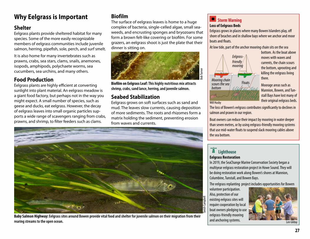
Eelgrass
Eelgrass is a plant that grows on the bottom of shallow sandy bays. It is an ecosystem engineer, altering the ecosystem around it.
Bob T
urne
r
Most of us have never seen an eelgrass plant, because they are hidden beneath the surface of our coves and bays. Growing at a maximum depth of seven metres, this plant is one of the most important components of the marine ecosystem around Bowen. Eelgrass forms the basis of a complex food web that includes salmon, dolphins, and orca. Eelgrass meadows are biodiversity hotspots, providing a home to a myriad of invertebrates, algae, fish, and microorganisms.
Rarely seen eelgrass seed. Most reproduce by shallow sideways-growing root-like rhizome.
Will
Husb
y
Despite its name, eelgrass is neither a grass nor a seaweed (marine algae). It is a perennial flowering plant adapted to living in salt water. It has dark green,
ribbon-like leaves 2 to 12 mm wide and between 20 and 100 cm long.
Will
Husb
y
Sources: Islands Trust (base map and location of eelgrass), Fiona Beaty, Ocean Watch (location of eelgrass restoration areas)
27
Baby Salmon Highway: Eelgrass sites around Bowen provide vital food and shelter for juvenile salmon on their migration from their rearing streams to the open ocean.
Tavis
h Cam
pbell
Why Eelgrass is ImportantShelterEelgrass plants provide sheltered habitat for many species. Some of the more easily recognizable members of eelgrass communities include juvenile salmon, herring, pipefish, sole, perch, and surf smelt.
It is also home for many invertebrates such as prawns, crabs, sea stars, clams, snails, anemones, isopods, amphipods, polychaete worms, sea cucumbers, sea urchins, and many others.
Food ProductionEelgrass plants are highly efficient at converting sunlight into plant material. An eelgrass meadow is a giant food factory, but perhaps not in the way you might expect. A small number of species, such as geese and ducks, eat eelgrass. However, the decay of eelgrass leaves into small organic particles sup-ports a wide range of scavengers ranging from crabs, prawns, and shrimp, to filter feeders such as clams.
BiofilmThe surface of eelgrass leaves is home to a huge complex of bacteria, single-celled algae, small sea-weeds, and encrusting sponges and bryozoans that form a brown felt-like covering or biofilm. For some grazers, an eelgrass shoot is just the plate that their dinner is sitting on.
Biofilm on Eelgrass Leaf: This highly nutritious mix attracts shrimp, crabs, sand lance, herring, and juvenile salmon.
Seabed StabilizationEelgrass grows on soft surfaces such as sand and mud. The leaves slow currents, causing deposition of more sediments. The roots and rhizomes form a matrix holding the sediment, preventing erosion from waves and currents.
Storm Warning Loss of Eelgrass Beds Eelgrass grows in places where many Bowen Islanders play, off shore of beaches and in shallow bays where we anchor and moor boats and floats. At low tide, part of the anchor mooring chain sits on the sea
bottom. As the boat above moves with waves and currents, the chain scours the bottom, uprooting and killing the eelgrass living there.
Moorage areas such as Mannion, Bowen, and Tun-stall Bays have lost many of their original eelgrass beds.
The loss of Bowen’s eelgrass contributes significantly to declines in salmon and prawn in our region.
Boat owners can reduce their impact by mooring in water deeper than seven metres, or by using eelgrass-friendly mooring systems that use mid-water floats to suspend slack mooring cables above the sea bottom.
Mooring chain scours the sea bottom
Eelgrass-friendly mooring
Floats
LighthouseEelgrass RestorationIn 2019, the SeaChange Marine Conservation Society began a multiyear eelgrass restoration project in Howe Sound. They will be doing restoration work along Bowen’s shores at Mannion, Columbine, Tunstall, and Bowen Bays. The eelgrass replanting project includes opportunities for Bowen volunteer participation. Also, protection of our existing eelgrass sites will require cooperation by local boat owners pledging to use eelgrass-friendly mooring and anchoring systems.
Bob T
urne
r
Will Husby
Len Gilday

28
Estuaries
The Causeway separates Terminal Creek’s freshwater Lagoon from the saltwater of Atl’ka7tsem/Howe Sound.
Our Estuaries: Stream Mouth Tidal Flats Estuaries are rich habitats created where streams meet the sea. If a stream empties onto an exposed shoreline, fine sand and mud is washed offshore by storm waves, leaving only a beach of gravel and coarse sand. But where a stream empties into a protected bay, extensive tidal flats of sand and mud can accumulate to support rich intertidal life. On Bowen Island, southern Mannion/Deep Bay and Snug Cove are such protected bays with streams. However, human constructions have radically changed the tidal flats of both bays.
The Lagoon: a Uniquely Rich Habitat It might surprise you that the Lagoon on Mannion/Deep Bay is both a biological hotspot and the most human-modified shoreline on Bowen Island. The Lagoon was once a narrow inlet of the ocean where at low tide Terminal Creek flowed across tidal flats. At high tide, the inlet was filled by the ocean. Construction of the Causeway in the 1920s dammed the flow of Terminal Creek, forming the freshwater Lagoon.
The bridge over the tidal inlet in 1914, before construction of the Causeway and formation of the Lagoon
Today Terminal Creek tumbles into the head of the Lagoon, and its waters flow slowly through the Lagoon to the Causeway, where they spill into the ocean. Seaward of the Causeway, the outer part of the original tidal flats are still exposed at a very low tide.
As many islanders know, the Lagoon is the go-to place to see mallard, swans, merganser, Canada geese, and even beaver.
Beaver feeding on shoreline vegetation at the Lagoon
Pied-billed grebe preparing to swallow a crayfish
Female hooded merganser with a minnow meal
In spite of its human-made origin, the Lagoon provides a unique estuarine habitat. Cutthroat trout, schools of stickleback, and otter swim back and forth between Lagoon and ocean, and in the fall, salmon spawn on the constructed gravel bed in the Lagoon by the Causeway bridge.
Bob T
urne
r Bob T
urne
r
City o
f Van
couv
er A
rchive
s
Will
Husb
yW
ill Hu
sby
29
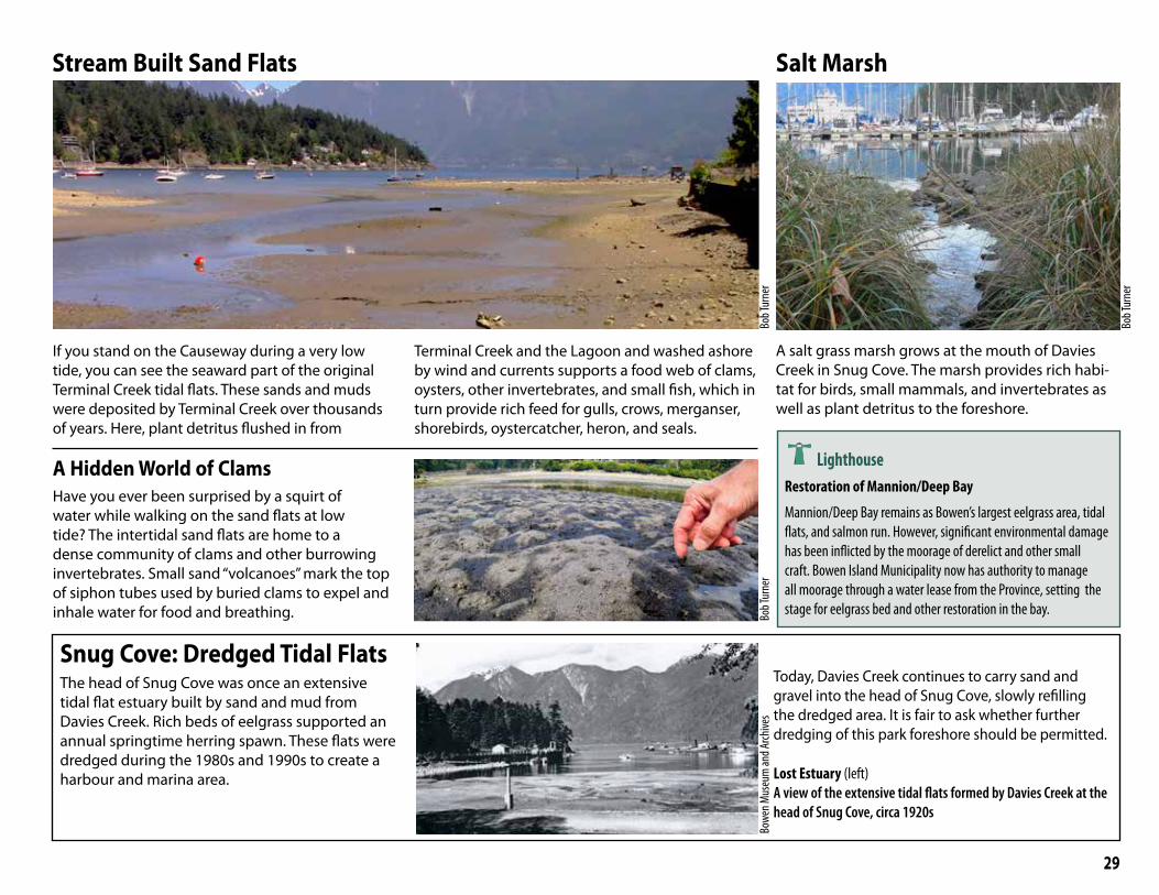
If you stand on the Causeway during a very low tide, you can see the seaward part of the original Terminal Creek tidal flats. These sands and muds were deposited by Terminal Creek over thousands of years. Here, plant detritus flushed in from
Terminal Creek and the Lagoon and washed ashore by wind and currents supports a food web of clams, oysters, other invertebrates, and small fish, which in turn provide rich feed for gulls, crows, merganser, shorebirds, oystercatcher, heron, and seals.
Stream Built Sand Flats
A Hidden World of Clams Have you ever been surprised by a squirt of water while walking on the sand flats at low tide? The intertidal sand flats are home to a dense community of clams and other burrowing invertebrates. Small sand “volcanoes” mark the top of siphon tubes used by buried clams to expel and inhale water for food and breathing.
Snug Cove: Dredged Tidal Flats The head of Snug Cove was once an extensive tidal flat estuary built by sand and mud from Davies Creek. Rich beds of eelgrass supported an annual springtime herring spawn. These flats were dredged during the 1980s and 1990s to create a harbour and marina area.
Today, Davies Creek continues to carry sand and gravel into the head of Snug Cove, slowly refilling the dredged area. It is fair to ask whether further dredging of this park foreshore should be permitted.
Lost Estuary (left)A view of the extensive tidal flats formed by Davies Creek at the head of Snug Cove, circa 1920s
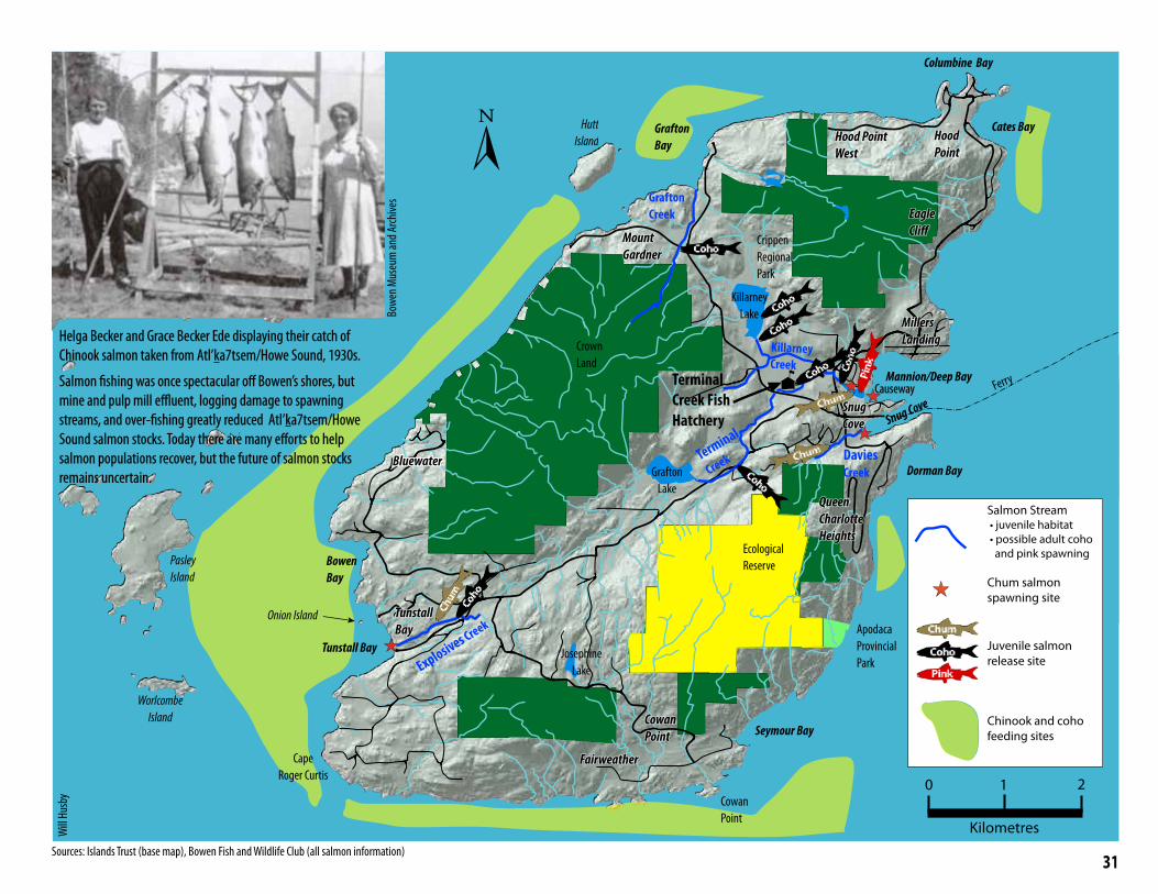
Salt Marsh
A salt grass marsh grows at the mouth of Davies Creek in Snug Cove. The marsh provides rich habi-tat for birds, small mammals, and invertebrates as well as plant detritus to the foreshore.
LighthouseRestoration of Mannion/Deep Bay
Mannion/Deep Bay remains as Bowen’s largest eelgrass area, tidal flats, and salmon run. However, significant environmental damage has been inflicted by the moorage of derelict and other small craft. Bowen Island Municipality now has authority to manage all moorage through a water lease from the Province, setting the stage for eelgrass bed and other restoration in the bay.
Bob T
urne
rBo
b Tur
ner
Bob T
urne
r
Bowe
n Mus
eum
and A
rchive
s

30
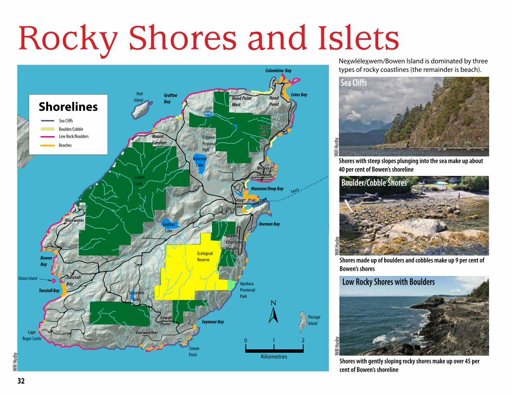
Salmon are woven into the very fabric of west coast culture; for thousands of years, First Nations harvested salmon from streams during annual fall salmon runs. Salmon also have a key role in Atl’ka7tsem/Howe Sound’s marine food web.
Nexwlélexwem/Bowen Island sits like an immovable boulder in the middle of two great living rivers of salmon: the Fraser River and the Squamish River runs. Each year, runs of coho, chum, pink, Chinook and sockeye salmon swim past Bowen on their way to spawning grounds up the Fraser, Squamish, and other nearby rivers.
Salmon Movement is in Two DirectionsMost spawning takes place in fall and winter. Eggs lie buried in stream for several months. In late winter or spring, juvenile salmon hatch and emerge into the stream.
Juvenile chum salmon quickly head for the sea to fatten up along our shorelines, but juvenile coho will spend a year in our streams before heading to sea. Schools of juvenile chum and coho are com-mon along Bowen's shores, feeding on plankton and sheltering in seaweed and eelgrass beds.
Salmon Watching on Bowen
Chum are our dominant salmon, and each year sexually mature adults return from the open Pacific, to the streams where they were born, to mate and die (see map on the facing page). Returns vary each year from a few fish to as many as 2000 in 2016.
Coho salmon arrive in smaller numbers to spawn in the upper reaches of Terminal Creek.
The best place to safely watch spawning salmon is the Causeway across the mouth of Killarney Creek at Mannion/Deep Bay.
Eventually, the young salmon migrate into the open Pacific Ocean where they feedand grow for two to four years.
Storm Warning Climate Change Salmon are cold water fish that thrive in the icy waters of the Pacific Ocean and cool freshwater streams such as Bowen’s Killarney and Terminal Creeks. Our salmon face a cascading series of environmental stresses, ranging from increases in ocean and stream temperatures, reductions in the amount of dissolved oxygen in the water, changes in availability of food organisms due to ocean acidification, and reduced water flow in spawning streams due to summer droughts. Only time will tell if our salmon can adapt to all these changes.
Salmon
LighthouseHelping Salmon on BowenSince the early 1980s, the Bowen Island Fish and Wildlife Club has been part of Fisheries and Oceans Canada’s (DFO) Salmon Enhancement Program working to restore Pacific salmon stocks. DFO scientists have identified five streams that support salmon populations (see map).
The club and DFO built the Terminal Creek Salmon Hatchery and the Bridal Veil Falls fish ladders in Terminal Creek in Crippen Park. The hatchery raises chum, coho, and sometimes pink salmon from eggs collected from spawning salmon near mainland hatcheries. Club volunteers release the juvenile salmon into four salmon streams during the spring.
Today, club volunteers, under the supervision of DFO, operate the hatchery, monitor the health of Bowen waterways, conduct salmon habitat rehabilitation of creeks, and educate school children and the Bowen community about the protection of wild salmon and their habitat. Visit the Bowen Island Fish and Wildlife Club website for information on their projects and volunteer activities.
Juvenile coho salmon in Terminal Creek
Will
Husb
y
Will
Husb
y
Fraser Run
Squamish Run
BowenBowenIslandIsland
Fraser River
Squamish River
Will
Husb
y
Will
Husb
y
Bob T
urne
r
Source: Alamy Stock Photo
31
Killarney Creek
Terminal
Creek Davies Creek
Explosives Creek
Grafton Creek
Terminal Creek Fish Hatchery
Crippen Regional Park
Ecological Reserve
Snug Cove
Mannion/Deep Bay
Cates Bay
Tunstall Bay
Bowen Bay
Grafton Bay
Seymour Bay
Cape Roger Curtis
Cowan Point
BBlluueewwaatteerrGrafton
Lake
KillarneyLake
Bluewater
Queen Charlotte Heights
CowanPoint
SnugCove
EagleCliff
Hood Point
MountGardner
ApodacaProvincial Park
TunstallBay
Josephine Lake
Crown Land
Millers Landing
Fairweather
Hood Point West
Passage Island
Worlcombe Island
Pasley Island
Keats Island
Hutt Island
Ferry
Columbine Bay
Dorman Bay
Onion Island
Salmon Stream • juvenile habitat • possible adult coho and pink spawning
Chum salmon spawning site
Juvenile salmon release site
Chinook and coho feeding sites
[
0 1 2
Kilometres
CausewayCauseway
Helga Becker and Grace Becker Ede displaying their catch of Helga Becker and Grace Becker Ede displaying their catch of Chinook salmon taken from Atl’Chinook salmon taken from Atl’kka7tsem/Howe Sound, 1930s. a7tsem/Howe Sound, 1930s.
Salmon fishing was once spectacular off Bowen’s shores, but Salmon fishing was once spectacular off Bowen’s shores, but mine and pulp mill effluent, logging damage to spawning mine and pulp mill effluent, logging damage to spawning streams, and over-fishing greatly reduced Atl’streams, and over-fishing greatly reduced Atl’kka7tsem/Howe a7tsem/Howe Sound salmon stocks. Today there are many efforts to help Sound salmon stocks. Today there are many efforts to help salmon populations recover, but the future of salmon stocks salmon populations recover, but the future of salmon stocks remains uncertain.remains uncertain.
Sources: Islands Trust (base map), Bowen Fish and Wildlife Club (all salmon information)
Will
Husb
y
Bowe
n Mus
eum
and A
rchive
s
32
Beaches
Low Rock/BouldersBoulder/Cobble
Sea Cliffs
Shorelines
Crippen Regional Park
Ecological Reserve
Snug Cove
Mannion/Deep Bay
Cates Bay
Tunstall Bay
Bowen Bay
Grafton Bay
Seymour Bay
Cape Roger Curtis
Cowan Point
BBlluueewwaatteerrGrafton
Lake
KillarneyLake
Bluewater
Queen Charlotte Heights
CowanPoint
SnugCove
EagleCliff
Hood Point
MountGardner
ApodacaProvincial Park
TunstallBay
Josephine Lake
Crown Land
Millers Landing
Fairweather
Hood Point West
Passage Island
Worlcombe Island
Pasley Island
Keats Island
Hutt Island
Ferry
Columbine Bay
Dorman Bay
Onion Island
0 1 2
Kilometres
[
Rocky Shores and Islets Nexwlélexwem/Bowen Island is dominated by three types of rocky coastlines (the remainder is beach).
Low Rocky Shores with Boulders
Boulder/Cobble Shores
Shores with gently sloping rocky shores make up over 45 per cent of Bowen’s shoreline
Shores made up of boulders and cobbles make up 9 per cent of Bowen’s shores
Shores with steep slopes plunging into the sea make up about 40 per cent of Bowen’s shoreline
Sea Cliffs
Will
Husb
yW
ill Hu
sby
Will
Husb
y
Will
Husb
y

33
Life on Rocky Shores
Rocky shores have extreme environments caused by wave action and twice-daily exposure at low tide
Organisms that live on rocky shores have adapted to tolerate exposure to air, extreme heat and cold, drying, predation, and battering by waves.
Despite the harsh, stressful conditions, the many cracks, crevices, and depressions in this landscape make it possible for a surprising diversity of plants and animals to live here.
Blood Star from the cobble shore of Galbraith Bay
Zones Subtidal ZoneThis region is usually covered with water. It is only exposed when the tide is extremely low. In con-trast to the other zones, the organisms are not well adapted to long periods of dryness or extreme temperatures.
Subtidal
Lower Intertidal
Upper Intertidal
Splash Zone Black Lichen
Acorn Barnacles
MusselsRockweed
Ochre Stars
Kelp
Douglas Fir
Arbutus
Salal
Extreme High Tide
Extreme Low Tide
Tide Pool
Will
Husb
y
Bat Star
Intertidal ZoneThis zone is the fringe of the sea bed between the highest and lowest limit of the tides. At low tide, intertidal organisms face both heat and drying stresses.
This zone is divided in two sections:• Upper intertidal zone. This region is only flooded
during high tides. Organisms that live here spend a lot of time exposed to the air.
• Lower intertidal zone. The zone extends from the lower limit of the mussels to the upper limit of most kelp. Organisms that live here spend more time immersed in sea water.
Tide Pools. These rocky seawater pools are the best place to see marine life close-up.
Orange-spotted Nudibranch in a tidepool
When the tide retreats, creatures in the pool become isolated from the rest of the ocean. At high tide, new sea water enters the pool. Bowen has few tide pools. The most accessible are near the Cape Roger Curtis lighthouse.
Splash ZoneThe splash zone is the region just above high tide level. It is moist-ened by the spray of the break-ing waves and is only wetted by sea water during storms and extremely high tides. Living things are exposed to severe conditions here, such as drying heat of the sun in the summer, salt accumula-tion, and extreme low tem-peratures in the winter. Only a few hardy organisms, such as lichens, live here.
Will
Husb
y
Will
Husb
y
Will
Husb
y
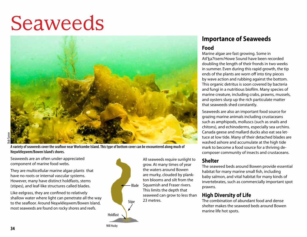
34
Seaweeds
A variety of seaweeds cover the seafloor near Worlcombe Island. This type of bottom cover can be encountered along much of Nexwlélexwem/Bowen Island’s shores.
Holdfast
Stipe
Blade
Seaweeds are an often under-appreciated component of marine food webs.
They are multicellular marine algae plants that have no roots or internal vascular systems. However, many have distinct holdfasts, stems (stipes), and leaf-like structures called blades.
Like eelgrass, they are confined to relatively shallow water where light can penetrate all the way to the seafloor. Around Nexwlélexwem/Bowen Island, most seaweeds are found on rocky shores and reefs.
All seaweeds require sunlight to grow. At many times of year the waters around Bowen are murky, clouded by plank-ton blooms and silt from the Squamish and Fraser rivers. This limits the depth that seaweed can grow to less than 23 metres.
Importance of SeaweedsFoodMarine algae are fast growing. Some in Atl’ka7tsem/Howe Sound have been recorded doubling the length of their fronds in two weeks in summer. Even during this rapid growth, the tip ends of the plants are worn off into tiny pieces by wave action and rubbing against the bottom. This organic detritus is soon covered by bacteria and fungi in a nutritious biofilm. Many species of marine creature, including crabs, prawns, mussels, and oysters slurp up the rich particulate matter that seaweeds shed constantly.
Seaweeds are also an important food source for grazing marine animals including crustaceans such as amphipods, molluscs (such as snails and chitons), and echinoderms, especially sea urchins. Canada geese and mallard ducks also eat sea let-tuce at low tide. Many of their detached blades are washed ashore and accumulate at the high tide mark to become a food source for a thriving de-composer community of insects and crustaceans.
ShelterThe seaweed beds around Bowen provide essential habitat for many marine small fish, including baby salmon, and vital habitat for many kinds of invertebrates, such as commercially important spot prawns.
High Diversity of LifeThe combination of abundant food and dense shelter makes the seaweed beds around Bowen marine life hot spots.
Bob T
urne
r
Will Husby

35
Types of SeaweedsMarine algae fall into three distinct groups:
• brown algae • green algae • red algae
All three groups can be observed around Nexwlélexwem/Bowen Island. The shores of Bowen are home for many species. No current list of species is available. Four common types are discussed here.
Rockweed
At high tide, rockweed’s built-in flotation suspends the plants upright in the water column, providing plenty of hiding places for small fish who come to forage for baby shrimp and plankton.
Rockweed is the most commonly observed seaweed around Bowen. The plant forms broad, dense canopies in the mid intertidal zone and can extend well into the high zone. They tolerate a wide range of salinities, including areas washed over by fresh water.
At low tide rockweed lies flat, providing shelter and protection from desiccation to invertebrates and other algae.
Sea Lettuce
Sea lettuce are beautiful light-to emerald-green seaweed with a delicate translucence. Some species have broad blades, while other species, as in this photo, are made up of thin strands.
Sea lettuces are another shallow water seaweed. Several species can be found around Nexwlélexwem/Bowen Island on sheltered and intertidal exposed rocks and in tide pools. They have been recorded at depths of 23 metres. They tolerate a wide range of sa-linity and can thrive in brackish waters. Their presence is often a sign of freshwater springs seeping into bays.
Sea Colander
This is the most widespread and dominant subtidal habitat-forming kelp species in Howe Sound. But because it grows only in deeper waters (6 to 18 metres), it is seldom seen by the casual observer.
Unlike many areas of the Pacific coast, Howe Sound has no kelp forests. Giant kelp is absent and bull kelp is rare. Instead, expanses of low-lying sea colander kelp form diverse multi-level kelp “shrublands” that, like kelp forests, have very high biodiversity. The animal life here includes more than 10 major groups of marine creatures.
Sargassum
This large, yellowish-brown or olive-brown seaweed can be distinguished from most other Pacific coast seaweeds by its small, round float bladders. It often takes the form of floating mats near the surface.
Sargassum is widespread on shallow rocky shores around Bowen. It is a fast-growing invasive species from Japan that often crowds out native seaweeds. It is not clear what impact this has on the ecology of juvenile salmon and invertebrates that depend on native seaweeds for food and shelter.
Will
Husb
y
Will
Husb
y
Will
Husb
yJ.
Alsta
tt
Storm Warning Urchin Barrens Sea colander habitat has been declining in Howe Sound since 2013 when the loss of top-predator sunflower stars led to an increase in kelp grazers like the green sea urchin. Unchecked by predators, voracious green urchins are converting kelp shrublands into urchin barrens.
Bob T
urne
r
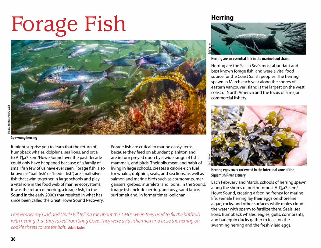
36
Forage Fish
Spawning herring
It might surprise you to learn that the return of humpback whales, dolphins, sea lions, and orca to Atl’ka7tsem/Howe Sound over the past decade could only have happened because of a family of small fish few of us have ever seen. Forage fish, also known as “bait fish” or “feeder fish”, are small silver fish that swim together in large schools and play a vital role in the food web of marine ecosystems. It was the return of herring, a forage fish, to the Sound in the early 2000s that resulted in what has since been called the Great Howe Sound Recovery.
Forage fish are critical to marine ecosystems because they feed on abundant plankton and are in turn preyed upon by a wide range of fish, mammals, and birds. Their oily meat, and habit of living in large schools, creates a calorie-rich fuel for whales, dolphins, seals, and sea lions, as well as salmon and marine birds such as cormorants, mer-gansers, grebes, murrelets, and loons. In the Sound, forage fish include herring, anchovy, sand lance, surf smelt and, in former times, oolichan.
Herring
Herring are an essential link in the marine food chain.
Herring are the Salish Sea’s most abundant and best known forage fish, and were a vital food source for the Coast Salish peoples. The herring spawn in March each year along the shores of eastern Vancouver Island is the largest on the west coast of North America and the focus of a major commercial fishery.
Herring eggs cover rockweed in the intertidal zone of the Squamish River estuary.
Each February and March, schools of herring spawn along the shores of northernmost Atl’ka7tsem/Howe Sound, creating a feeding frenzy for marine life. Female herring lay their eggs on shoreline algae, rocks, and other surfaces while males cloud the water with sperm to fertilize them. Seals, sea lions, humpback whales, eagles, gulls, cormorants, and harlequin ducks gather to feast on the swarming herring and the freshly laid eggs.
I remember my Dad and Uncle Bill telling me about the 1940s when they used to fill the bathtub with herring that they raked from Snug Cove. They were avid fishermen and froze the herring on cookie sheets to use for bait. Adam Taylor
Ian M
cAllis
ter/P
acifi
c Wild
Bob T
urne
rBo
b Tur
ner
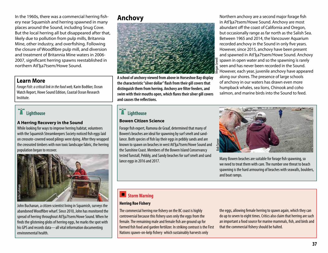
37
Anchovy
A school of anchovy viewed from above in Horseshoe Bay display the characteristic “silver dollar” flash from their gill covers that distinguish them from herring. Anchovy are filter feeders, and swim with their mouths open, which flares their silver gill covers and causes the reflections.
Northern anchovy are a second major forage fish in Atl’ka7tsem/Howe Sound. Anchovy are most abundant off the coast of California and Oregon, but occasionally range as far north as the Salish Sea. Between 1965 and 2014, the Vancouver Aquarium recorded anchovy in the Sound in only five years. However, since 2015, anchovy have been present and spawned in Atl’ka7tsem/Howe Sound. Anchovy spawn in open water and so the spawning is rarely seen and has never been recorded in the Sound. However, each year, juvenile anchovy have appeared along our shores. The presence of large schools of anchovy in our waters has drawn even more humpback whales, sea lions, Chinook and coho salmon, and marine birds into the Sound to feed.
In the 1960s, there was a commercial herring fish-ery near Squamish and herring spawned in many places around the Sound, including Snug Cove. But the local herring all but disappeared after that, likely due to pollution from pulp mills, Britannia Mine, other industry, and overfishing. Following the closure of Woodfibre pulp mill, and diversion and treatment of Britannia Mine waters in 2006-2007, significant herring spawns reestablished in northern Atl’ka7tsem/Howe Sound.
Learn MoreForage Fish: a critical link in the food web, Karin Bodtker, Ocean Watch Report, Howe Sound Edition, Coastal Ocean Research Institute.
Storm Warning Herring Roe Fishery
The commercial herring roe fishery on the BC coast is highly controversial because this fishery uses only the eggs from the female. The remaining male and female fish are ground up for farmed fish food and garden fertilizer. In striking contrast is the First Nations spawn-on-kelp fishery which sustainably harvests only
the eggs, allowing female herring to spawn again, which they can do up to seven to eight times. Critics also claim that herring are such an important a food source for marine mammals, fish, and birds and that the commercial fishery should be halted.
Lighthouse Bowen Citizen Science
Forage fish expert, Ramona de Graaf, determined that many of Bowen’s beaches are ideal for spawning by surf smelt and sand-lance. Both species of fish lay their eggs in pebbly sands and are known to spawn on beaches in west Atl’ka7tsem/Howe Sound and the Sunshine Coast. Members of the Bowen Island Conservancy tested Tunstall, Pebbly, and Sandy beaches for surf smelt and sand lance eggs in 2016 and 2017. Many Bowen beaches are suitable for forage fish spawning, so
we need to treat them with care. The number one threat to beach spawning is the hard armouring of beaches with seawalls, boulders, and boat ramps.
Meg
an Se
well
Bob T
urne
r
Lighthouse
A Herring Recovery in the SoundWhile looking for ways to improve herring habitat, volunteers with the Squamish Streamkeepers Society noticed fish eggs laid on creosote-covered wood pilings were dying. After they wrapped the creosoted timbers with non toxic landscape fabric, the herring population began to recover.
John Buchanan, a citizen scientist living in Squamish, surveys the abandoned Woodfibre wharf. Since 2010, John has monitored the spread of herring throughout Atl’ka7tsem/Howe Sound. When he finds the glistening globs of herring eggs, he marks the spot with his GPS and records data—all vital information documenting environmental health.
John
Lehm
an

38
Deep Waters
Pilot Erica Bergman and team prepare the Aquatica submersible before setting out on an expedition to the sponge reef off Lions Bay.
Sixgill Sharks
Sixgill shark seen from Aquatica submersible 100 metres down
Swimming near the ocean floor, sixgill sharks are a relatively sedentary species. Males can reach five metres and females 3.5 metres in length. They have a broad, pointed head, six pairs of gill slits (most sharks have five) and a long tail. Sixgill sharks, with their keen sense of smell, are among the first to ar-rive at carrion—the decaying flesh of dead animals. Not much is known about sixgill sharks’ abundance
or biology because they spend most of their life hundreds of metres down in dark, cold water.
This species was not known in the Sound until 2010, when they were encountered on two separate occasions by researchers with Ocean Wise. In 2017, a three-person research submersible recorded three juvenile sixgills between Nexwlélexwem/Bowen Island and Whytecliff Park at a depth of 100 metres.
According to the Vancouver Aquarium, sixgills, like all sharks, have the potential to bite, although the aquarium has no reports of them doing so. Vancouver Aquarium scientists are trying to track sixgill sightings in Atl’ka7tsem/Howe Sound. If you see one, please report it to the Ocean Wise Research Institute.
Rockfish
Further up the water column, living among the rocky outcrops of the Sound’s seamounts and reefs, 14 species of rockfish have been recorded. They often shelter in cracks, crevasses, and under boulders.
In the 1960s, bocaccio, black and yelloweye (all rockfish species) were hit hard by salmon sport fishers who discarded rockfish as “trash fish.” In the 1980s, rockfish were targeted on a reef-by-reef basis for the live fish market. By the late 1980s, rockfish populations were reduced to less than 15 per cent of original numbers.
A deacon and a yelloweye (left) and 2 quillback (right), all rockfish species, in a glass sponge reef
Copper rockfish in crack
Adam
Taylo
rCh
ris H
arve
y-Cla
rk
Adam
Taylo
r
Adam Taylor
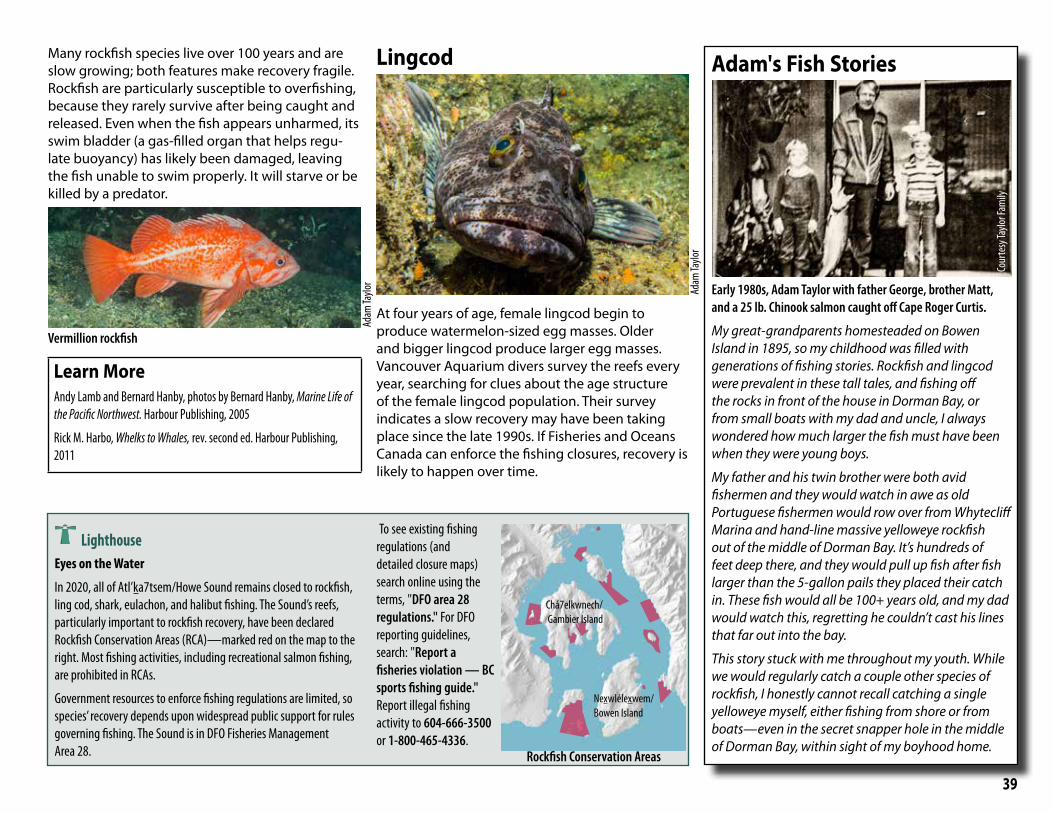
39
Many rockfish species live over 100 years and are slow growing; both features make recovery fragile. Rockfish are particularly susceptible to overfishing, because they rarely survive after being caught and released. Even when the fish appears unharmed, its swim bladder (a gas-filled organ that helps regu-late buoyancy) has likely been damaged, leaving the fish unable to swim properly. It will starve or be killed by a predator.
Vermillion rockfish
Learn MoreAndy Lamb and Bernard Hanby, photos by Bernard Hanby, Marine Life of the Pacific Northwest. Harbour Publishing, 2005
Rick M. Harbo, Whelks to Whales, rev. second ed. Harbour Publishing, 2011
Lingcod
At four years of age, female lingcod begin to produce watermelon-sized egg masses. Older and bigger lingcod produce larger egg masses. Vancouver Aquarium divers survey the reefs every year, searching for clues about the age structure of the female lingcod population. Their survey indicates a slow recovery may have been taking place since the late 1990s. If Fisheries and Oceans Canada can enforce the fishing closures, recovery is likely to happen over time.
Adam's Fish Stories
Early 1980s, Adam Taylor with father George, brother Matt, and a 25 lb. Chinook salmon caught off Cape Roger Curtis.
My great-grandparents homesteaded on Bowen Island in 1895, so my childhood was filled with generations of fishing stories. Rockfish and lingcod were prevalent in these tall tales, and fishing off the rocks in front of the house in Dorman Bay, or from small boats with my dad and uncle, I always wondered how much larger the fish must have been when they were young boys.
My father and his twin brother were both avid fishermen and they would watch in awe as old Portuguese fishermen would row over from Whytecliff Marina and hand-line massive yelloweye rockfish out of the middle of Dorman Bay. It’s hundreds of feet deep there, and they would pull up fish after fish larger than the 5-gallon pails they placed their catch in. These fish would all be 100+ years old, and my dad would watch this, regretting he couldn’t cast his lines that far out into the bay.
This story stuck with me throughout my youth. While we would regularly catch a couple other species of rockfish, I honestly cannot recall catching a single yelloweye myself, either fishing from shore or from boats—even in the secret snapper hole in the middle of Dorman Bay, within sight of my boyhood home.
Lighthouse Eyes on the Water
In 2020, all of Atl’ka7tsem/Howe Sound remains closed to rockfish, ling cod, shark, eulachon, and halibut fishing. The Sound’s reefs, particularly important to rockfish recovery, have been declared Rockfish Conservation Areas (RCA)—marked red on the map to the right. Most fishing activities, including recreational salmon fishing, are prohibited in RCAs.
Government resources to enforce fishing regulations are limited, so species’ recovery depends upon widespread public support for rules governing fishing. The Sound is in DFO Fisheries Management Area 28.
To see existing fishing regulations (and detailed closure maps) search online using the terms, "DFO area 28 regulations." For DFO reporting guidelines, search: "Report a fisheries violation — BC sports fishing guide." Report illegal fishing activity to 604-666-3500 or 1-800-465-4336.
Nexwlélexwem/Bowen Island
Adam
Taylo
r
Adam
Taylo
r
Chá7elkwnech/ Gambier Island
Rockfish Conservation Areas
Cour
tesy
Taylo
r Fam
ily

40
Glass Sponge Reefs
Adam Taylor photographed this lingcod among the cloud sponge on Gambier Island’s Halkett Point reef. Adam has found shiner perch, seen swimming above the reef, congregate year-round on Atl’ka7tsem/Howe Sound’s shallow sponge reefs. Adam speculates that the upwelling and nutrients created by the sponges may be concentrating the plankton, thereby attracting plankton-eating shiner perch, which in turn attract larger predators such as lingcod.
A sponge is an animal without a mouth, muscles, heart, or brain. Lacking nervous, digestive, or circulatory systems, these extraordinary animals work rather like chimneys: with bodies full of pores and channels, sponges take in seawater at the
bottom; actively pull the water through their pores using whip-like flagella; obtain food and oxygen and remove waste; then eject it from their osculum (”little mouth") at the top. Most sponges contain structural particles of calcium while a few, called
"glass sponges,” contain silica. The cloud sponge, Atl’ka7tsem/Howe Sound’s predominant sponge, is a fragile, reef-building glass sponge. Because many of the Sound’s reefs are in relatively shallow water, this is the only place in the world a recre-ational diver can explore a glass sponge reef (GSR) using scuba gear.
Sponge Reef Fishery ClosureBecause prawns congregate around GSRs, the prawn fishery, for many years, has benefited from fishing near the reefs. Heavy prawn traps, crashing down into the 3D glass structures, cause cumula-tive damage to reefs and all the creatures who live there. In 2019, Fisheries and Oceans Canada (DFO) expanded fish closures around the Sound's GSRs to include a 150 metre buffer zone. Crab and prawn traps, shrimp trawlers, and other bottom contact fishing gear (including gear used to fish for groundfish such as halibut) are now completely prohibited around the protected reef footprint. The use of downrigger gear in recreational salmon trolling is also prohibited in these areas due to the risk of damage to shallow reefs. Enforcement of GSR fish closures is weak and poaching is com-mon. Learn how to identify and report illegal fishing activity to 604-666-3500. For maps of GSR fisheries closures search online using the phrase "Glass Sponge Reefs Howe Sound."
Learn MoreSheila Byers, "The Deep Sea Cities of Glass", Discovery 46 (2018).
Sheila Byers, "The Marine Life Sanctuary Society and Conservation of Howe Sound Rockfishes and Glass Sponge Reefs", Discovery 46 (2018).
DFO. 2018. Glass Sponge Aggregations in Howe Sound : locations, reef status, and ecological significance assessment. DFO. Can. Sci. Advis. Sec. Sci. Resp. 2018/032.
Wikipedia contains excellent articles on sponges and the effects of global warming on oceans.
Dead sponges mound cemented by sediment.
Dead spongesLive sponges
A glass sponge reef structure is called a bioherm — a reef of living sponges built on layer upon layer of dead sponges.
A bioherm is a biological hotspot and the submarine equivalent of an old growth forest.
Adam
Taylo
r
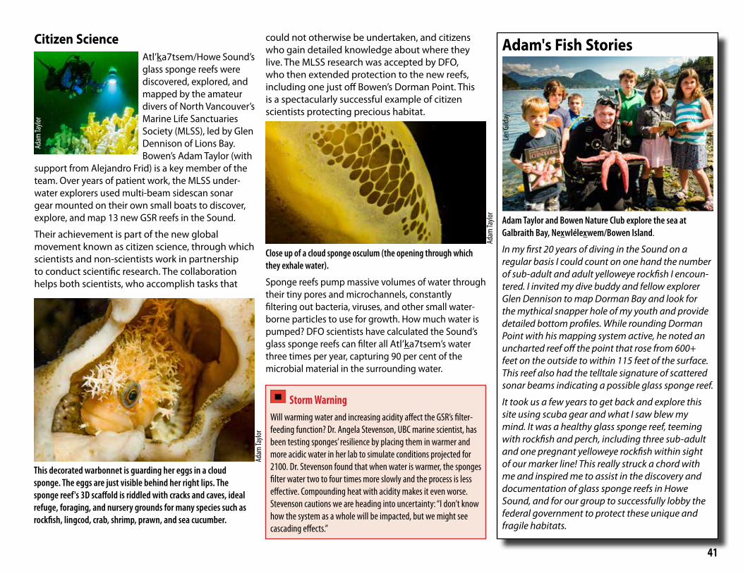
41
Citizen ScienceAtl’ka7tsem/Howe Sound’s glass sponge reefs were discovered, explored, and mapped by the amateur divers of North Vancouver’s Marine Life Sanctuaries Society (MLSS), led by Glen Dennison of Lions Bay. Bowen’s Adam Taylor (with
support from Alejandro Frid) is a key member of the team. Over years of patient work, the MLSS under-water explorers used multi-beam sidescan sonar gear mounted on their own small boats to discover, explore, and map 13 new GSR reefs in the Sound.
Their achievement is part of the new global movement known as citizen science, through which scientists and non-scientists work in partnership to conduct scientific research. The collaboration helps both scientists, who accomplish tasks that
could not otherwise be undertaken, and citizens who gain detailed knowledge about where they live. The MLSS research was accepted by DFO, who then extended protection to the new reefs, including one just off Bowen’s Dorman Point. This is a spectacularly successful example of citizen scientists protecting precious habitat.
Close up of a cloud sponge osculum (the opening through which they exhale water).
Sponge reefs pump massive volumes of water through their tiny pores and microchannels, constantly filtering out bacteria, viruses, and other small water-borne particles to use for growth. How much water is pumped? DFO scientists have calculated the Sound’s glass sponge reefs can filter all Atl’ka7tsem’s water three times per year, capturing 90 per cent of the microbial material in the surrounding water.
Adam's Fish Stories
Adam Taylor and Bowen Nature Club explore the sea at Galbraith Bay, Nexwlélexwem/Bowen Island.
In my first 20 years of diving in the Sound on a regular basis I could count on one hand the number of sub-adult and adult yelloweye rockfish I encoun-tered. I invited my dive buddy and fellow explorer Glen Dennison to map Dorman Bay and look for the mythical snapper hole of my youth and provide detailed bottom profiles. While rounding Dorman Point with his mapping system active, he noted an uncharted reef off the point that rose from 600+ feet on the outside to within 115 feet of the surface. This reef also had the telltale signature of scattered sonar beams indicating a possible glass sponge reef.
It took us a few years to get back and explore this site using scuba gear and what I saw blew my mind. It was a healthy glass sponge reef, teeming with rockfish and perch, including three sub-adult and one pregnant yelloweye rockfish within sight of our marker line! This really struck a chord with me and inspired me to assist in the discovery and documentation of glass sponge reefs in Howe Sound, and for our group to successfully lobby the federal government to protect these unique and fragile habitats.
Storm Warning Will warming water and increasing acidity affect the GSR’s filter-feeding function? Dr. Angela Stevenson, UBC marine scientist, has been testing sponges’ resilience by placing them in warmer and more acidic water in her lab to simulate conditions projected for 2100. Dr. Stevenson found that when water is warmer, the sponges filter water two to four times more slowly and the process is less effective. Compounding heat with acidity makes it even worse. Stevenson cautions we are heading into uncertainty: “I don’t know how the system as a whole will be impacted, but we might see cascading effects.”
Adam
Taylo
r
Adam
Taylo
r
Adam
Taylo
r
Len G
ilday
This decorated warbonnet is guarding her eggs in a cloud sponge. The eggs are just visible behind her right lips. The sponge reef's 3D scaffold is riddled with cracks and caves, ideal refuge, foraging, and nursery grounds for many species such as rockfish, lingcod, crab, shrimp, prawn, and sea cucumber.
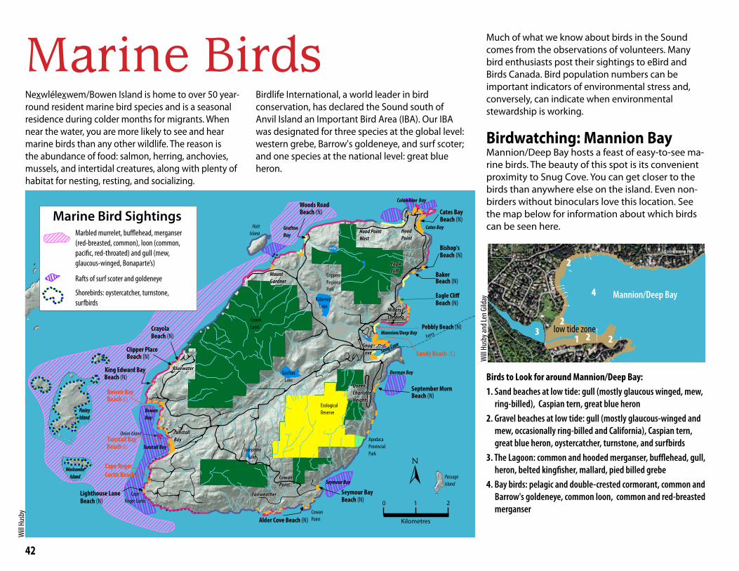
42
Marine Birds Nexwlélexwem/Bowen Island is home to over 50 year-round resident marine bird species and is a seasonal residence during colder months for migrants. When near the water, you are more likely to see and hear marine birds than any other wildlife. The reason is the abundance of food: salmon, herring, anchovies, mussels, and intertidal creatures, along with plenty of habitat for nesting, resting, and socializing.
Eagle Cliff
Sandy Beach (C)
Cape Roger Curtis Beach (C)
Tunstall Bay
Bowen Bay
Cates Bay
Bishop's
Baker
Pebbly Beach (N)
September Morn
Seymour Bay
Alder Cove Beach (N)
Lighthouse Lane
King Edward Bay
Clipper Place
Crayola
Woods Road
Beach (N)
Beach (N)
Beach (N)
Beach (N)
Beach (N)
Beach (N)Beach (N)
Beach (N)
Beach (N)
Beach (N)
Beach (N)
Beach (C)
Beach (C)
Crippen Regional Park
Ecological Reserve
Snug Cove
Mannion/Deep Bay
Cates Bay
Tunstall Bay
Bowen Bay
Grafton Bay
Seymour Bay
Cape Roger Curtis
Cowan Point
BBlluueewwaatteerrGrafton
Lake
KillarneyLake
Bluewater
Queen Charlotte Heights
CowanPoint
SnugCove
EagleCliff
Hood Point
MountGardner
ApodacaProvincial Park
TunstallBay
Josephine Lake
Crown Land
Millers Landing
Fairweather
Hood Point West
Passage Island
Worlcombe Island
Pasley Island
Keats Island
Hutt Island
Ferry
Columbine Bay
Dorman Bay
Onion Island
Marine Bird Sightings
0 1 2
Kilometres
[
Marbled murrelet, bufflehead, merganser (red-breasted, common), loon (common, pacific, red-throated) and gull (mew, glaucous-winged, Bonaparte’s)
Rafts of surf scoter and goldeneye
Shorebirds: oystercatcher, turnstone, surfbirds
Birdlife International, a world leader in bird conservation, has declared the Sound south of Anvil Island an Important Bird Area (IBA). Our IBA was designated for three species at the global level: western grebe, Barrow's goldeneye, and surf scoter; and one species at the national level: great blue heron.
Much of what we know about birds in the Sound comes from the observations of volunteers. Many bird enthusiasts post their sightings to eBird and Birds Canada. Bird population numbers can be important indicators of environmental stress and, conversely, can indicate when environmental stewardship is working.
Birdwatching: Mannion BayMannion/Deep Bay hosts a feast of easy-to-see ma-rine birds. The beauty of this spot is its convenient proximity to Snug Cove. You can get closer to the birds than anywhere else on the island. Even non-birders without binoculars love this location. See the map below for information about which birds can be seen here.
Birds to Look for around Mannion/Deep Bay:1. Sand beaches at low tide: gull (mostly glaucous winged, mew,
ring-billed), Caspian tern, great blue heron2. Gravel beaches at low tide: gull (mostly glaucous-winged and
mew, occasionally ring-billed and California), Caspian tern, great blue heron, oystercatcher, turnstone, and surfbirds
3. The Lagoon: common and hooded merganser, bufflehead, gull, heron, belted kingfisher, mallard, pied billed grebe
4. Bay birds: pelagic and double-crested cormorant, common and Barrow's goldeneye, common loon, common and red-breasted merganser
3
4 Mannion/Deep Bay
low tide zone
Will
Husb
y and
Len G
ilday
2
2
2
1 2
Will
Husb
y
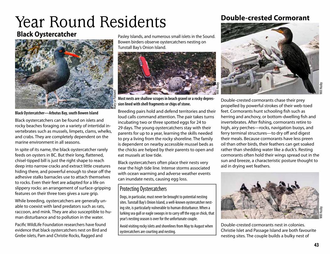
43
Black Oystercatcher
Black Oystercatcher—Arbutus Bay, south Bowen Island
Black oystercatchers can be found on islets and rocky beaches foraging on a variety of intertidal in-vertebrates such as mussels, limpets, clams, whelks, and crabs. They are completely dependent on the marine environment in all seasons.
In spite of its name, the black oystercatcher rarely feeds on oysters in BC. But their long, flattened, chisel-tipped bill is just the right shape to reach deep into narrow cracks and extract little creatures hiding there, and powerful enough to shear off the adhesive stalks barnacles use to attach themselves to rocks. Even their feet are adapted for a life on slippery rocks: an arrangement of surface-gripping features on their three toes gives a sure grip.
While breeding, oystercatchers are generally un-able to coexist with land predators such as rats, raccoon, and mink. They are also susceptible to hu-man disturbance and to pollution in the water.
Pacific WildLife Foundation researchers have found evidence that black oystercatchers nest on Bird and Grebe islets, Pam and Christie Rocks, Ragged and
Pasley Islands, and numerous small islets in the Sound. Bowen birders observe oystercatchers nesting on Tunstall Bay’s Onion Island.
Most nests are shallow scrapes in beach gravel or a rocky depres-sion lined with shell fragments or chips of stone.
Breeding pairs hold and defend territories and their loud calls command attention. The pair takes turns incubating two or three spotted eggs for 24 to 29 days. The young oystercatchers stay with their parents for up to a year, learning the skills needed to pry a living from the rocky shoreline. The family is dependent on nearby accessible mussel beds as the chicks are helped by their parents to open and eat mussels at low tide.
Black oystercatchers often place their nests very near the high tide line. Intense storms associated with ocean warming and adverse weather events can inundate nests, causing egg loss.
Protecting OystercatchersDogs, in particular, must never be brought to potential nesting sites. Tunstall Bay’s Onion Island, a well-known oystercatcher nest-ing site, is particularly vulnerable to human disturbance. When a lurking sea gull or eagle swoops in to carry off the egg or chick, that year’s nesting season is over for the unfortunate couple.
Avoid visiting rocky islets and shorelines from May to August when oystercatchers are courting and nesting.
Double-crested Cormorant
Double-crested cormorants chase their prey propelled by powerful strokes of their web-toed feet. Cormorants hunt schooling fish such as herring and anchovy, or bottom-dwelling fish and invertebrates. After fishing, cormorants retire to high, airy perches—rocks, navigation buoys, and ferry terminal structures—to dry off and digest their meals. Because cormorants have less preen oil than other birds, their feathers can get soaked rather than shedding water like a duck’s. Resting cormorants often hold their wings spread out in the sun and breeze, a characteristic posture thought to aid in drying wet feathers.
Double-crested cormorants nest in colonies. Christie Islet and Passage Island are both favourite nesting sites. The couple builds a bulky nest of
Year Round Residents
Mar
y Le P
atou
rel
Will
Husb
y
Will
Husb
yW
ill Hu
sby

44
grass, seaweeds, sticks, and moss. Both parents share incubating duties. After hatching, chicks spend another 25 to 30 days in the nest eating regurgitated fish brought by both parents. These colonies are conspicuous, not only because of the visible whitewash but also, downwind, from the pungent reek of guano and rotting fish. Cormorants can sometimes be seen from the ferry, roosting in the trees on the south side of Snug Cove.
In 1987, 119 pairs of double-crested cormorants nested on Christie Islet; in 2000 the colony was down to 42 nesting pairs. Researchers from the Pacific WildLife Foundation believe the decline can be attributed to the increased presence of bald eagles.
Great Blue HeronThe great blue heron is one of Bowen’s iconic marine birds. We see them roosting in tall trees, standing on docks, hunting in the shallows of rocky shores, and sharing beaches with us in summer.
That we see them often hides the fact that the Pacific great blue heron, the West Coast subspecies, is considered to be vulnerable and at risk of becoming a threatened or endangered species. One key factor affecting our herons is loss of nesting habitat as development encroaches, removing trees for nesting. As well, the decline of salmon populations is forcing bald eagles to shift from a fish diet to birds including herons, especially their nestlings and eggs.
Great blue herons are tree nesters. Traditionally, they gathered in remote nesting colonies, often with hundreds of nests.
Eagle predation has elicited new heron behaviours that help them to evade eagle attacks. Many now nest in small groups of nests or as single pairs close to busy human habitation, such as Snug Cove, where eagles are less likely to attack them and local crows rise up to mob invading eagles.
Heron on nest, Snug Cove
Bowen Island Municipality has a set of guidelines for protecting herons and their nesting sites. To find it online, use the phrase: "heron policy Bowen Island."
Mary Le Patourel lives on a sail-boat in Snug Cove and ventures out in all weather to spend time with Bowen birds. Mary shares her bird photos and observa-tions on social media. Here is a sample of one of her photos and comments.
Common Mergansers, Snug Cove
This photo of the common merganser and chicks was taken on the Lagoon. They fledged from Rondy’s merganser boxes at the USSC Marine. There are two boxes and each year two broods emerge about the same time as the Round Bowen Island Race. This year, this brood hatched the same day as the Race and as the sailors were heading to the beer garden, mother duck was tossing her chicks out of the bird box at one-day-old. Mother quickly assembled her youngsters on her back and she swam under darkness to Mannion/Deep Bay. There were more than 10 chicks to start with and the last time I saw them, there were four left. That’s pretty good considering the eagles and crows have to feed their young at the same time of year.
Mary’s Photos
Mar
y Le P
atou
rel
Len Gilday
Mar
y Le P
atou
relW
ill Hu
sby
Will
Husb
y
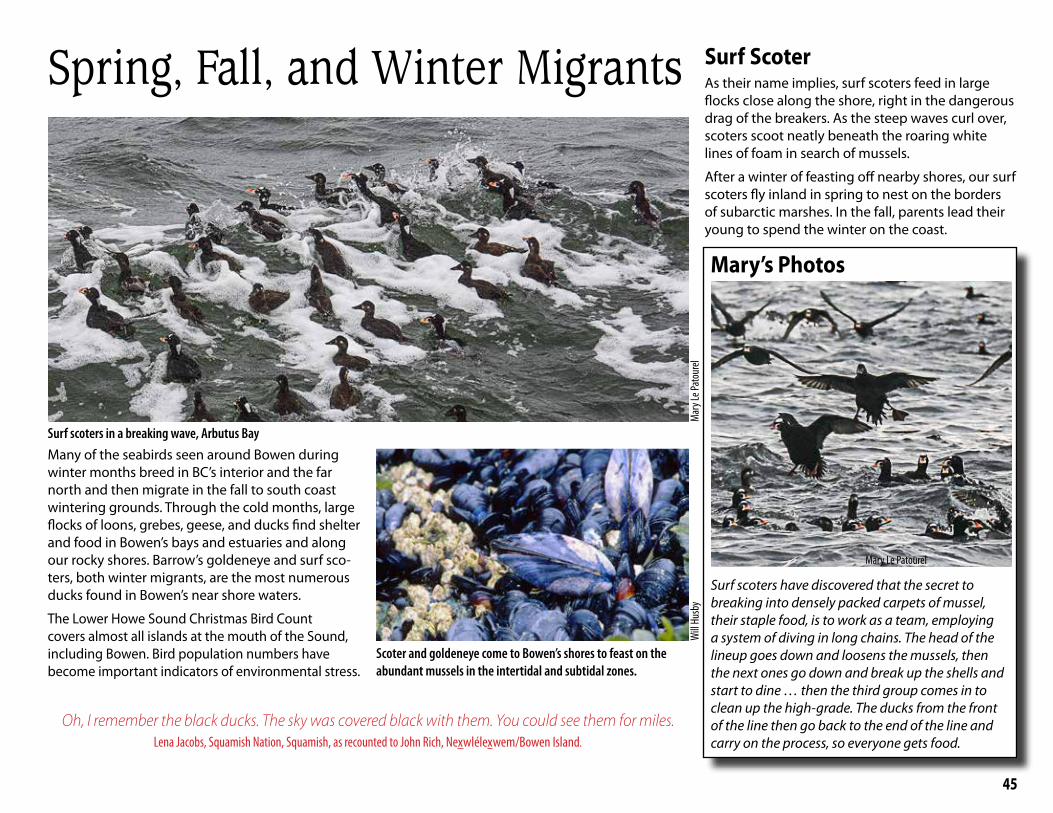
45
Spring, Fall, and Winter Migrants
Surf scoters in a breaking wave, Arbutus Bay
Mar
y Le P
atou
rel
Many of the seabirds seen around Bowen during winter months breed in BC’s interior and the far north and then migrate in the fall to south coast wintering grounds. Through the cold months, large flocks of loons, grebes, geese, and ducks find shelter and food in Bowen’s bays and estuaries and along our rocky shores. Barrow’s goldeneye and surf sco-ters, both winter migrants, are the most numerous ducks found in Bowen’s near shore waters.
The Lower Howe Sound Christmas Bird Count covers almost all islands at the mouth of the Sound, including Bowen. Bird population numbers have become important indicators of environmental stress.
Scoter and goldeneye come to Bowen’s shores to feast on the abundant mussels in the intertidal and subtidal zones.
Surf ScoterAs their name implies, surf scoters feed in large flocks close along the shore, right in the dangerous drag of the breakers. As the steep waves curl over, scoters scoot neatly beneath the roaring white lines of foam in search of mussels.
After a winter of feasting off nearby shores, our surf scoters fly inland in spring to nest on the borders of subarctic marshes. In the fall, parents lead their young to spend the winter on the coast.
Will
Husb
y
Mary’s Photos
Surf scoters have discovered that the secret to breaking into densely packed carpets of mussel, their staple food, is to work as a team, employing a system of diving in long chains. The head of the lineup goes down and loosens the mussels, then the next ones go down and break up the shells and start to dine … then the third group comes in to clean up the high-grade. The ducks from the front of the line then go back to the end of the line and carry on the process, so everyone gets food.
Mary Le Patourel
Oh, I remember the black ducks. The sky was covered black with them. You could see them for miles. Lena Jacobs, Squamish Nation, Squamish, as recounted to John Rich, Nexwlélexwem/Bowen Island.
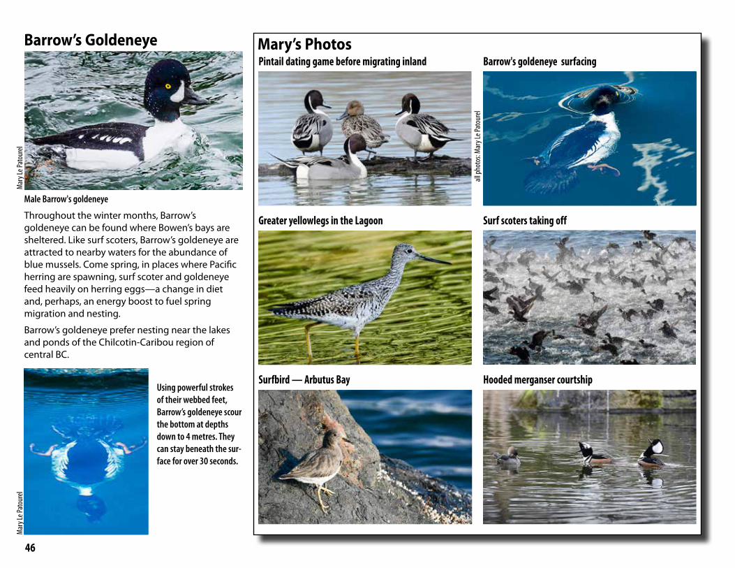
46
Barrow’s Goldeneye
Male Barrow's goldeneye
Throughout the winter months, Barrow’s goldeneye can be found where Bowen’s bays are sheltered. Like surf scoters, Barrow’s goldeneye are attracted to nearby waters for the abundance of blue mussels. Come spring, in places where Pacific herring are spawning, surf scoter and goldeneye feed heavily on herring eggs—a change in diet and, perhaps, an energy boost to fuel spring migration and nesting.
Barrow’s goldeneye prefer nesting near the lakes and ponds of the Chilcotin-Caribou region of central BC.
Using powerful strokes of their webbed feet, Barrow’s goldeneye scour the bottom at depths down to 4 metres. They can stay beneath the sur-face for over 30 seconds.
Mar
y Le P
atou
rel
Mar
y Le P
atou
rel
Pintail dating game before migrating inland
Greater yellowlegs in the Lagoon
Surfbird — Arbutus Bay
Barrow's goldeneye surfacing
Surf scoters taking off
Hooded merganser courtship
Mary’s Photos
all ph
otos
: Mar
y Le P
atou
rel

47
Lighthouse Ben Keen on Digital Birding
Nexwlélexwem/Bowen Island is one the best places in the province to find certain species. One winter morning, a friend and I saw just shy of 500 marbled murrelets off Cape Roger Curtis lighthouse. That’s truly a stunning number for that species. The west coast of Bowen has become one of my favourite birding spots. You can rely on a good variety of species
from Tunstall Bay or the lighthouse, but every now and then you get a rare surprise like Heerman’s gull, rhinoceros auklet, parasitic jaeger or wandering tattler… Hey, you never know!
The importance of citizen science projects like eBird and iNaturalist can’t be overstated. Just type eBird.org into a web browser and you get immediate access to up-to-date sightings, interactive species range maps, popular birding locations and more. They help funnel people’s knowledge and passion of the world’s flora and fauna into practical, accessible data sets. At over half a billion bird sightings now logged on eBird alone, that wealth of data helps conservationists determine what species are at risk and what locations need protection; it provides concrete data for law and policy makers to guide decisions around funding. Thanks to projects like these we now know far more about migration patterns, species decline, spread of invasive species, impact of habitat loss, and more.
Storm Warning Derelict Vessels and Toxic Spills
Abandoned sailboat, Mannion/Deep Bay
A boat that breaks loose and hits the rocks can release fuel, oil, and other pollutants directly into shallow water—exactly where sea birds and many small marine creatures hang out. When oil sticks to a bird’s feathers, compromising the feather’s waterproofing, the bird’s skin becomes exposed to cold ocean water, leading to hypothermia. An oil-soaked bird is unlikely to recover.
Once spilled oil seeps into bottom sediments, it is virtually impossible to clean up. For years to come, the poisons will seep and continue to kill birds, mammals, and invertebrates. New federal legislation prohibits vessel abandonment and strengthens owners’ responsibility and liability for hazardous vessels and wrecks. Success depends upon adequate enforcement.
While funding from Transport Canada’s Abandoned Boats Program helps the municipality clean up derelict vessels, a team of Bowen volunteer divers is working at removing trash from the bottom of Mannion/Deep Bay—tires, batteries, electric generators, and tonnes of garbage tossed overboard.
Bowen Waste Service hauls away abandoned vessel removed from Mannion/Deep Bay
Len G
ilday
Learn MoreeBird.org: The online database of bird observations
iNaturalist.org: The online global network of naturalists, citizen scientists, and biologists built on the concept of sharing observations of biodiversity
Atlas of the Breeding Birds of BC: Comprehensive online information about birds that breed in BC
Richard Cannings, Tom Aversa, Hal Opperman, Birds of Southwest-ern British Columbia, Heritage House Publishing, 2008
To take part in the Christmas Bird Count, check the Bowen Nature Club website.
Will
Husb
y
Len G
ilday
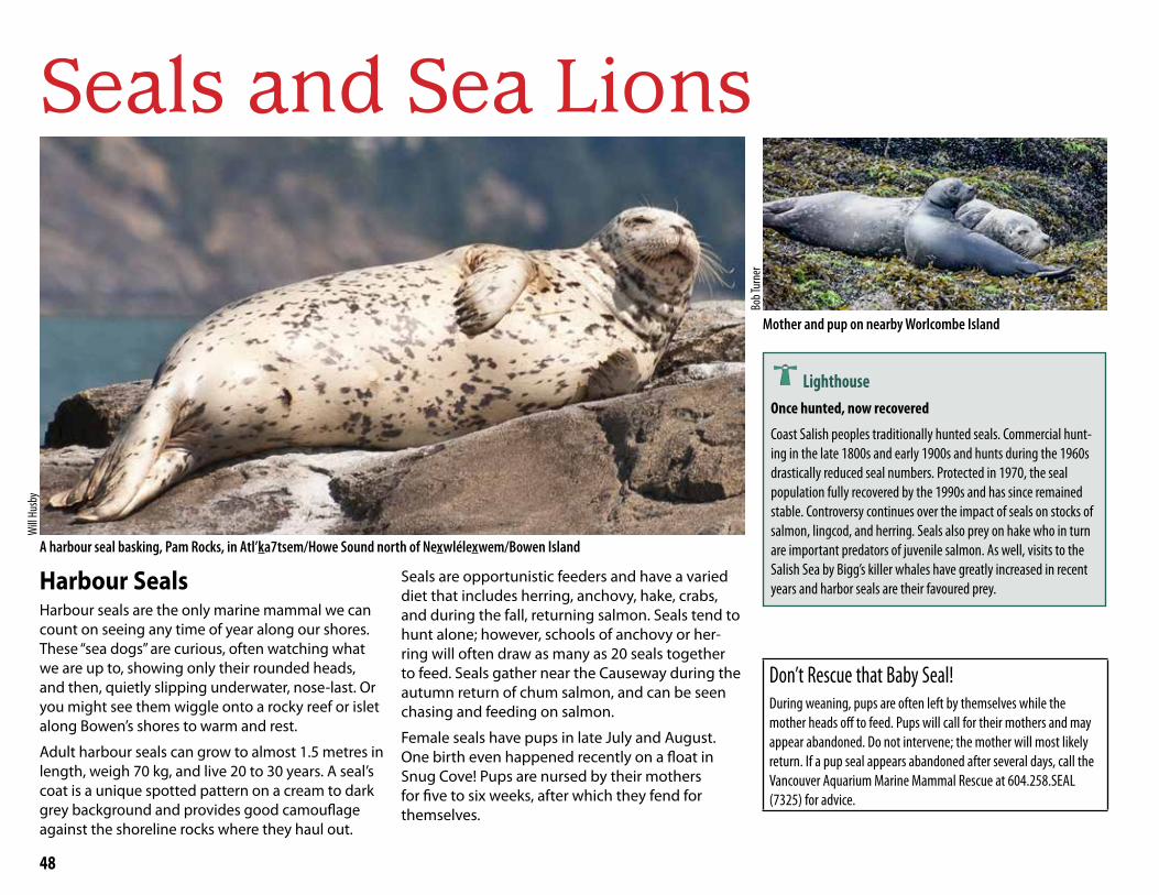
48
Seals and Sea Lions
Harbour SealsHarbour seals are the only marine mammal we can count on seeing any time of year along our shores. These “sea dogs” are curious, often watching what we are up to, showing only their rounded heads, and then, quietly slipping underwater, nose-last. Or you might see them wiggle onto a rocky reef or islet along Bowen’s shores to warm and rest.
Adult harbour seals can grow to almost 1.5 metres in length, weigh 70 kg, and live 20 to 30 years. A seal’s coat is a unique spotted pattern on a cream to dark grey background and provides good camouflage against the shoreline rocks where they haul out.
A harbour seal basking, Pam Rocks, in Atl’ka7tsem/Howe Sound north of Nexwlélexwem/Bowen Island
Seals are opportunistic feeders and have a varied diet that includes herring, anchovy, hake, crabs, and during the fall, returning salmon. Seals tend to hunt alone; however, schools of anchovy or her-ring will often draw as many as 20 seals together to feed. Seals gather near the Causeway during the autumn return of chum salmon, and can be seen chasing and feeding on salmon.
Female seals have pups in late July and August. One birth even happened recently on a float in Snug Cove! Pups are nursed by their mothers for five to six weeks, after which they fend for themselves.
Mother and pup on nearby Worlcombe Island
LighthouseOnce hunted, now recovered
Coast Salish peoples traditionally hunted seals. Commercial hunt-ing in the late 1800s and early 1900s and hunts during the 1960s drastically reduced seal numbers. Protected in 1970, the seal population fully recovered by the 1990s and has since remained stable. Controversy continues over the impact of seals on stocks of salmon, lingcod, and herring. Seals also prey on hake who in turn are important predators of juvenile salmon. As well, visits to the Salish Sea by Bigg’s killer whales have greatly increased in recent years and harbor seals are their favoured prey.
Don’t Rescue that Baby Seal! During weaning, pups are often left by themselves while the mother heads off to feed. Pups will call for their mothers and may appear abandoned. Do not intervene; the mother will most likely return. If a pup seal appears abandoned after several days, call the Vancouver Aquarium Marine Mammal Rescue at 604.258.SEAL (7325) for advice.
Will
Husb
y
Bob T
urne
r
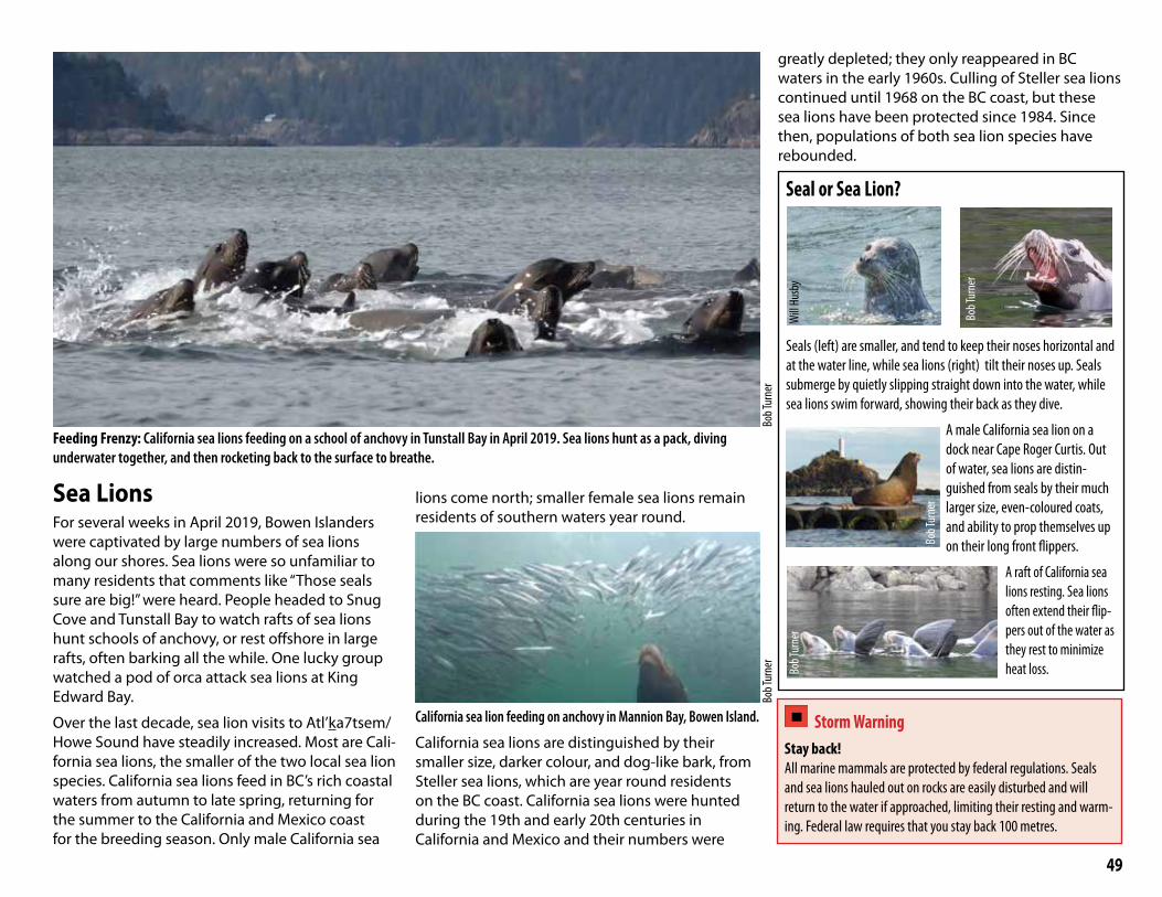
49
Sea LionsFor several weeks in April 2019, Bowen Islanders were captivated by large numbers of sea lions along our shores. Sea lions were so unfamiliar to many residents that comments like “Those seals sure are big!” were heard. People headed to Snug Cove and Tunstall Bay to watch rafts of sea lions hunt schools of anchovy, or rest offshore in large rafts, often barking all the while. One lucky group watched a pod of orca attack sea lions at King Edward Bay.
Over the last decade, sea lion visits to Atl’ka7tsem/Howe Sound have steadily increased. Most are Cali-fornia sea lions, the smaller of the two local sea lion species. California sea lions feed in BC’s rich coastal waters from autumn to late spring, returning for the summer to the California and Mexico coast for the breeding season. Only male California sea
lions come north; smaller female sea lions remain residents of southern waters year round.
California sea lion feeding on anchovy in Mannion Bay, Bowen Island.
California sea lions are distinguished by their smaller size, darker colour, and dog-like bark, from Steller sea lions, which are year round residents on the BC coast. California sea lions were hunted during the 19th and early 20th centuries in California and Mexico and their numbers were
greatly depleted; they only reappeared in BC waters in the early 1960s. Culling of Steller sea lions continued until 1968 on the BC coast, but these sea lions have been protected since 1984. Since then, populations of both sea lion species have rebounded.
Feeding Frenzy: California sea lions feeding on a school of anchovy in Tunstall Bay in April 2019. Sea lions hunt as a pack, diving underwater together, and then rocketing back to the surface to breathe.
Bob T
urne
rBo
b Tur
ner
Seal or Sea Lion?
Seals (left) are smaller, and tend to keep their noses horizontal and at the water line, while sea lions (right) tilt their noses up. Seals submerge by quietly slipping straight down into the water, while sea lions swim forward, showing their back as they dive.
A male California sea lion on a dock near Cape Roger Curtis. Out of water, sea lions are distin-guished from seals by their much larger size, even-coloured coats, and ability to prop themselves up on their long front flippers.
A raft of California sea lions resting. Sea lions often extend their flip-pers out of the water as they rest to minimize heat loss.Bo
b Tur
ner
Bob T
urne
r
Will
Husb
y
Bob T
urne
r
Storm Warning Stay back! All marine mammals are protected by federal regulations. Seals and sea lions hauled out on rocks are easily disturbed and will return to the water if approached, limiting their resting and warm-ing. Federal law requires that you stay back 100 metres.

50
Whales and Dolphins
A pair of humpback whales in Tunstall Bay, on Bowen’s western shore in 2018. The small hump just ahead of the dorsal fin gives the whale its name.
Anyone who has witnessed the great dorsal fin of a male orca or the breach of a humpback whale knows well the awe that these magnificent animals
can bring to our lives. The return of whales and dolphins to Atl’ka7tsem/Howe Sound after years of absence has galvanized public belief that the
Sound is recovering after decades of industrial pollution.
Bob T
urne
r

51
OrcaKiller whales, or orca as they are also known, after their Latin name Orcinus orca, are the cetacean most often seen in Atl’ka7tsem/Howe Sound. Squamish Nation traditions tell that the northwestern waters of the Sound were orca calving grounds in former times. Anecdotal information from residents of the Sound suggests that killer whales visited the Sound regularly in the 1960s and 1970s but were largely absent during the 1980s and 1990s. Their regular visits began again in the early 2000s and have increased to the present day.
Interestingly, killer whales are not whales at all, but rather the world’s largest dolphin. Four dis-tinct populations of killer whale inhabit BC coastal waters: northern and southern resident, Bigg's, and offshore. The killer whales that visit Atl’ka7tsem/Howe Sound are primarily the mammal-eating
variety, once known as transient killer whales but recently renamed as Bigg’s killer whales. Bigg's killer whales have greatly increased their visits to the Salish Sea over the last few years, likely drawn by the healthy populations of seals, their prey. Seals, sea lions, dolphins, and porpoises have excel-lent hearing, so these orca are stealth hunters that travel in small groups of three to six animals and use surprise to catch their prey off guard.
Bigg's killer whales travel as families led by a matriarch. Adult sons are usually larger than their mothers and distinguished by tall dorsal fins that can reach 1.5 metres in height. The name Bigg's killer whales honours Canadian marine biologist Michael Bigg, who recognized unique markings on each whale that allow us to know these orca as individual whales and whale families. In other words, as neighbours.
Orca on the Hunt: In April 2017, two families of Bigg's killer whales trapped a California sea lion against the hull of a boat near Bowyer Island just east of Nexwlélexwem/Bowen Island and attempted unsuccessfully to dislodge it with rushes, jumps, and bubble blows. Orca are identified by the shape of the white saddle patch just behind their dorsal fin.
The first documented visit to Atl’ka7tsem/Howe Sound by northern resident killer whales was a mother and four offspring near Hutt Island in February 2018. This male orca, named A66 or “Surf”, is the eldest offspring of A42 (“Sonora”). Northern residents, like the threatened southern resident killer whales, prey on salmon, primarily Chinook.
The threatened southern resident killer whales rarely visit Atl’ka7tsem/Howe Sound. These salm-on-eating killer whales suffer from a lack of food, as the stocks of Chinook salmon, their favoured prey, have dwindled in the past 40 years. Curiously, they show no interest in eating the abundant marine mammals around them.
Bob T
urne
r
Bob T
urne
rEll
iot Fu
nt

52
DolphinsPacific white-sided dolphins often travel in schools of 10 to 200, either as a compact group when travelling, or widely spaced when hunting. When travelling quickly they “porpoise”, leaping com-pletely from the water to breathe. Most common in the offshore waters of the BC coast, over the past two decades they have greatly increased their visits into the Salish Sea.
From 2011 to 2014, large schools of white-sided dolphins were regular visitors to Atl’ka7tsem/Howe Sound. Since 2015, dolphins have continued to visit the Sound, though in smaller numbers.
Return of the HumpbacksIt is remarkable that a somewhat common whale species in Atl’ka7tsem/Howe Sound today was absent from our waters for a century and only reap-peared in 2008. The return of humpback whales to the Sound is an amazing part of our local marine recovery. In the early 1900s, Captain J. A. Cates of the Terminal Steamship Company ran whale-watching tours into Atl’ka7tsem/Howe Sound to see humpback whales. In 1907, the Sechart Whal-ing Company began hunting whales in the Strait of Georgia. Captain Cates protested to his parliamen-tary representative that whalers had killed over 20 whales in the Sound in four months. His concerns went unheeded and, in 1908, the whalers ran out of whales, and moved to the west coast of Vancou-ver Island. Whaling continued in the North Pacific for another six decades, decimating humpback and other whale populations. In 1972, the International Whaling Commission ended the commercial whale
Bob T
urne
r
Hunted Humpbacks: Deceased humpback whale at Nanaimo whaling station, 1907-8
A school of Pacific white-sided dolphins
Imag
e E-0
6690
cour
tesy
of th
e Roy
al M
useu
m an
d Arch
ives

53
hunt, and since that time humpback whales have slowly reclaimed their traditional home on the BC coast. In the last 15 years, steadily increasing num-bers of humpback whales have reentered the Salish Sea, including Howe Sound.
Humpback whales come to the BC coast from spring to fall to feed in our rich coastal waters, and this is the time that they are most often seen in Atl’ka7tsem/Howe Sound. In late fall, they migrate south for the winter, mostly to Mexico or Hawaii, where calves are born. Humpback whales have the longest flippers of any whale, allowing them to be highly maneuverable and acrobatic. Their scientific name, Megaptera, means “large wing”. They range in size up to 12 metres long and 40 tonnes. Hump-back whales feed by straining small organisms through fine plates or baleen in their mouths. They are “gulpers” and lunge with their mouths open at dense patches of prey such as krill and copepods, or schooling fish such as herring and anchovy. In 2018, humpback whales were noted feeding on schools of anchovy along the west side of Bowen.
Unique tails: Individual humpbacks are identified by unique patterns on the their tail flukes and shape of their dorsal fins. This whale, photographed off Tunstall Bay in October 2018, is named “Yogi” for the pattern on its left fluke that looks like a bear’s face.
Peter Smith, white man, used to live at Brockton Point, and made a living spearing whales. He used to catch them off Bowen Island, and take them to Swis-pus-tah-kwin-ade (Worlcombe Island), Westminster, and Victoria. When the white man come, he did the same as Indians had done before. When white man go to Bowen Island, he find lots whale bone lying on the beach, and call it “Bone Island." August Jack Khatsahlahno
Bob T
urne
r
Storm Warning Stay Back!
Federal regulations require that you stay back 200 metres from orca and 100 metres from all marine mammals. Humpback whales are unpredictable in their movements and highly acrobatic. Collisions with boaters are dangerous for both humans and whales.
Kayakers dangerously close to a breaching humpback whale
Bob T
urne
r
Lighthouse Report Your Sighting
You can report your sighting of a whale, dolphin, or porpoise, online or by phone, to the BC Cetacean Sightings Network (wildwhales.org). Your data helps scientists to learn more about the movements of cetaceans and helps them advise government on policies that help protect our marine mammals.
Will
Husb
y
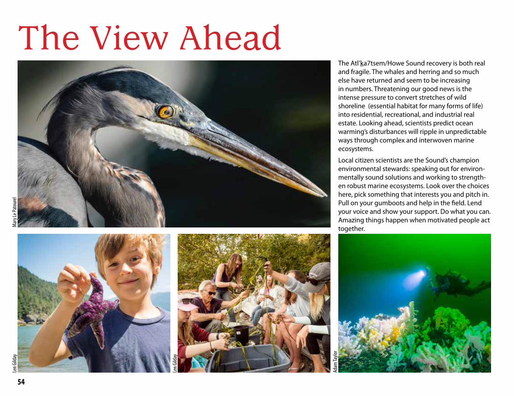
54
The View AheadThe Atl’ka7tsem/Howe Sound recovery is both real and fragile. The whales and herring and so much else have returned and seem to be increasing in numbers. Threatening our good news is the intense pressure to convert stretches of wild shoreline (essential habitat for many forms of life) into residential, recreational, and industrial real estate. Looking ahead, scientists predict ocean warming’s disturbances will ripple in unpredictable ways through complex and interwoven marine ecosystems.
Local citizen scientists are the Sound’s champion environmental stewards: speaking out for environ-mentally sound solutions and working to strength-en robust marine ecosystems. Look over the choices here, pick something that interests you and pitch in. Pull on your gumboots and help in the field. Lend your voice and show your support. Do what you can. Amazing things happen when motivated people act together. M
ary L
e Pat
oure
lLe
n Gild
ay
Len G
ilday
Adam
Taylo
r

55
Get Involved, Make a Contribution, Learn More, Be a Citizen ScientistOrganization What They Do
BC Cetacean Sightings Network
A conservation and research program of the Ocean Wise Research Institute in partnership with DFO. Report your marine mammal sighting by phone, online, email, or WhaleReport App.
Birds Canada
Canada's national bird conservation organization— its mission is to advance the understanding, appreciation, and conservation of wild birds and their habitats. Bowen volunteers do monthly Birds Canada Waterbird Surveys to monitor our seabirds.
Bowen Island Conservancy
Committed to protecting and preserving the natural environment of Nexwlélexwem/Bowen Island. Advocates for conservation issues and sponsors guest speakers, hikes, trail building, and this Marine Atlas. Oversees Islands Trust Conservancy lands.
Bowen Island Fish & Wildlife Club
Manages the Terminal Creek Hatchery. Conducts salmon en-hancement, stream keeping, and education such as Salmon in the Schools and the Coho Bon Voyage event each June.
Bowen Nature ClubDedicated to the enjoyment, understanding, and preservation of Bowen Island's biodiversity. Sponsors outdoor walks and other educational activities.
Christmas Bird CountNorth America's longest-running citizen science project. Counts happen in over 2000 locations throughout the Western Hemisphere, including Bowen Island.
David Suzuki Foundation
Conserves and protects the natural environment to create a sustainable Canada through evidence-based research, policy analysis, education, and citizen empowerment. The DSF hosts the online Atl’ka7tsem/Howe Sound Marine Conservation Assessment map, rich with data about our coastal inlet (howesoundconservation.ca).
eBird
The world’s largest biodiversity-related citizen science project and birding community. Participants can submit observations, share sightings, and view results via interactive online maps and graphs, including our local area.
Future of Howe Sound Society
Devoted to preserving the natural beauty and important ecosys-tems found in Howe Sound.
Organization What They Do
Howe Sound/Atl’ka7tsem Marine Reference Guide
An initiative to improve aquatic ecosystem health in Atl’ka7tsem/Howe Sound by bringing together information about the region's aquatic, ecological, and human-use values. This knowledge will be available in an online map designed to support informed decision making, collaborative management, marine spatial planning, and community education (howesoundguide.ca). Release is expected in spring 2021.
Howe Sound Biosphere Region Initiative Society
An initiative to gain designation for Atl’ka7tsem/Howe Sound as a UNESCO Biosphere Region.
Marine Life Sanctuaries Society
Conducts citizen-science research of glass sponge reefs and other marine areas and advocates for their protection. Runs Beach Interpretation Programs, sometimes on Bowen.
My Sea to SkyInspires and empowers British Columbians to safeguard the spectacular natural legacy of Howe Sound. Advocates against industrialization of the Sound.
Ocean Wise Research Institute,OceanWatch: Howe Sound Edition
Objective information about the Howe Sound coastal ocean region in British Columbia. The information is designed to inspire better decisions for nature and people. Published in 2017 and updated in 2020. Available online.
Ocean Wise Research Institute,Howe Sound Biodiversity
Researches coastal ecology, nearshore biodiversity, and under-water natural history, primarily in Howe Sound.
Pacific WildLife Foundation
Inspires conservation of coastal and marine ecosystems through scientific inquiry and education.
Report Fisheries Violations Report a fishing violation at: 604-666-3500 or 1-800-465-4336
SeaChange Marine Conservation Society
Connects ecosystems, cultures, and communities by educating young people and the public about marine and watershed ecol-ogy through interactive outdoor programs. Through the Salish Sea Nearshore Habitat Recovery Project, SeaChange is cleaning up the ocean floor and restoring eelgrass and shoreline vegeta-tion in the Salish Sea.
Squamish Lil’wat Cultural Centre, Whistler
Shares the Squamish and Lil’wat Nations' cultural knowledge and inspires understanding and respect amongst all people.

56
Exploring Bowen’s Marine World dives beneath the surface to introduce the plants and animals who live around Bowen’s shores and outlines the environmental conditions wild nature needs to thrive. We also offer science-based answers to up-to-date questions such as: How might warming ocean temperatures and changing ocean chemistry affect Atl’ka7tsem/Howe Sound’s marine webs?
What is the value to nature of preserving extensive stretches of wild shoreline? How long have the people of the Squamish Nation travelled Atl’ka7tsem to fish, harvest clams, and hunt seals and sea lion? Who are the local environmental stewards advocating for the things nature needs? This Atlas is stuffed full of challenging questions and new ways of exploring Bowen’s marine world.
The Bowen Island Conservancy is committed to The Bowen Island Conservancy is committed to protecting and preserving the natural wonders of protecting and preserving the natural wonders of NeNexxwlélewlélexxwem/Bowen Island, enhancing the quality wem/Bowen Island, enhancing the quality of life for current and future generations of residents of life for current and future generations of residents and visitors.and visitors.
All proceeds from sales of this book will be used to All proceeds from sales of this book will be used to promote marine conservation and education.promote marine conservation and education.